Westbury, New York Neighborhood Map - Income, House Prices, Occupations, Boundaries
Settings
X

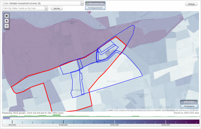
- City boundary
- Neighborhood boundaries
Business Search - 14 Million verified businesses
Neighborhoods:
Birchwood Knolls, Central Westbury, Downtown, Sherwood Gardens, The Hedges, Vllage Green, West JerichoBirchwood Knolls neighborhood in Westbury statistics: (Find on map)
Area: 0.150 square miles
Population: 758
Population density:
Median household income in 2021:
Male vs Females
Median age
Average estimated value of detached houses in 2021 (100.0% of all units):
Most popular occupations of males: service occupations (18.6%); management occupations (except farmers) (18.4%); architecture and engineering occupations (10.4%); sales and office occupations (9.5%); healthcare practitioners and technical occupations (9.1%); arts, design, entertainment, sports, and media occupations (8.6%); material moving occupations (6.8%)
Most popular occupations of females: sales and office occupations (29.4%); healthcare practitioners and technical occupations (25.9%); education, training, and library occupations (15.6%); business and financial operations occupations (12.4%); management occupations (except farmers) (12.2%); arts, design, entertainment, sports, and media occupations (4.5%); transportation occupations (2.8%)
Limited-access highways (interstate or state) in this neighborhood: Northern State Pkwy.
Roads and streets: Queen St; Alicia Dr; Powells Ln; Benine Rd; Advent St; Cambridge Ave; Franklin St; Warren St; Duke St; Canterbury St; Advent Pl; Walden St; Knight Dr; Dana Ln; Mc Kenna Rd; Queen Ct.
Birchwood Knolls neighborhood detailed profile
Area: 0.150 square miles
Population: 758
Population density:
| Birchwood Knolls: | 5,039 people per square mile |
| Westbury: | 6,612 people per square mile |
Median household income in 2021:
| Birchwood Knolls: | $169,653 |
| Westbury: | $114,863 |
Male vs Females
| Males: | 370 |
| Females: | 388 |
Median age
| Males: | 47.4 years |
| Females: | 47.1 years |
Average estimated value of detached houses in 2021 (100.0% of all units):
| Birchwood Knolls: | $679,797 |
| New York: | $441,759 |
Most popular occupations of males: service occupations (18.6%); management occupations (except farmers) (18.4%); architecture and engineering occupations (10.4%); sales and office occupations (9.5%); healthcare practitioners and technical occupations (9.1%); arts, design, entertainment, sports, and media occupations (8.6%); material moving occupations (6.8%)
Most popular occupations of females: sales and office occupations (29.4%); healthcare practitioners and technical occupations (25.9%); education, training, and library occupations (15.6%); business and financial operations occupations (12.4%); management occupations (except farmers) (12.2%); arts, design, entertainment, sports, and media occupations (4.5%); transportation occupations (2.8%)
Limited-access highways (interstate or state) in this neighborhood: Northern State Pkwy.
Roads and streets: Queen St; Alicia Dr; Powells Ln; Benine Rd; Advent St; Cambridge Ave; Franklin St; Warren St; Duke St; Canterbury St; Advent Pl; Walden St; Knight Dr; Dana Ln; Mc Kenna Rd; Queen Ct.
Birchwood Knolls neighborhood detailed profile
Central Westbury neighborhood in Westbury statistics: (Find on map)
Area: 1.117 square miles
Population: 10,021
Population density:
Median household income in 2021:
Median rent in in 2021:
Male vs Females
Median age
Housing prices:
Average estimated value of detached houses in 2021 (58.7% of all units):
Average estimated '21 value of housing units in 5-or-more-unit structures (28.5% of all units):
Most popular occupations of males: service occupations (16.6%); production occupations (15.5%); education, training, and library occupations (11.8%); transportation occupations (9.3%); construction, extraction, and maintenance occupations (7.9%); life, physical, and social science occupations (6.3%); sales and office occupations (6.3%)
Most popular occupations of females: service occupations (27.9%); sales and office occupations (21.8%); education, training, and library occupations (10.6%); production occupations (9.1%); healthcare practitioners and technical occupations (7.7%); community and social services occupations (6.0%); material moving occupations (4.4%)
Limited-access highways (interstate or state) in this neighborhood: Wantagh State Pkwy.
Roads and streets: Broadway; Prospect Ave; Railroad Ave; Brush Hollow Rd; Rockland St; Union Ave; Jefferson St; Park Ave; Cross St; Oxford St; Livingston St; Grand Blvd; Rutland St; Franklin St; School St; Roman Ave; Sheridan St; Center St; Maplewood Dr; 1st Ave; Siegel St; Dartmouth St; Grand Ave; Sherman St; Urban Ave; Brooklyn Ave; Linden Ave; Brook St; 4th Ave; Powells Ln; Garden St; Circle Dr; Kinkel St; Hopper St; Wright St; State St; Sylvester Ave (Sylvester St); New York Ave; Rushmore St; Monitor St; Dover St; Division St; 3rd Ave; Cambridge Ave; Magnolia Ave; 2nd Ave; Bond St; Newton St; Winthrop St; Madison St; Maple Ave; Upland St; Swalm St; Nassau St; 6th St; Costar St; Elizabeth St; Clinton St; Covert St; King St; Pearl St; 1st St; Church St; Linden Pl; Francis Dr; Hicksville Rd; Hicks St; Arbor Ln; Talbot Dr; 2nd St; Grant St; Catherine St; Willow St; Northfield Ln; Jaymie Dr; Hillcrest Dr; Garland Ln; Floral Ln; Walton Pl; Bramble Ln; Dogwood Ln; Clover Ln; Elderberry Ln; Shomer Pl; Princeton St; 3rd St; Columbia St; Melrick Ct; Malaney Ave; Portland Ave; 4th St; Holly Ln; Sullivan Ln; 5th St; E Broadway St; Rose Pl; Juniper Ln; Seaman Ct; E Broadway; Cassel Ct; Spruce St; Hill Crest Dr; Westbury Hicksville Rd.
Railroad features: Long Island RR.
Central Westbury neighborhood detailed profile
Area: 1.117 square miles
Population: 10,021
Population density:
| Central Westbury: | 8,972 people per square mile |
| Westbury: | 6,612 people per square mile |
Median household income in 2021:
| Central Westbury: | $120,811 |
| Westbury: | $114,863 |
Median rent in in 2021:
| Central Westbury: | $1,825 |
| Westbury: | $1,843 |
Male vs Females
| Males: | 4,601 |
| Females: | 5,419 |
Median age
| Males: | 44.9 years |
| Females: | 33.7 years |
Housing prices:
Average estimated value of detached houses in 2021 (58.7% of all units):
| Central Westbury: | $429,733 |
| New York: | $441,759 |
Average estimated '21 value of housing units in 5-or-more-unit structures (28.5% of all units):
| Central Westbury: | $259,601 |
| New York: | $784,206 |
Most popular occupations of males: service occupations (16.6%); production occupations (15.5%); education, training, and library occupations (11.8%); transportation occupations (9.3%); construction, extraction, and maintenance occupations (7.9%); life, physical, and social science occupations (6.3%); sales and office occupations (6.3%)
Most popular occupations of females: service occupations (27.9%); sales and office occupations (21.8%); education, training, and library occupations (10.6%); production occupations (9.1%); healthcare practitioners and technical occupations (7.7%); community and social services occupations (6.0%); material moving occupations (4.4%)
Limited-access highways (interstate or state) in this neighborhood: Wantagh State Pkwy.
Roads and streets: Broadway; Prospect Ave; Railroad Ave; Brush Hollow Rd; Rockland St; Union Ave; Jefferson St; Park Ave; Cross St; Oxford St; Livingston St; Grand Blvd; Rutland St; Franklin St; School St; Roman Ave; Sheridan St; Center St; Maplewood Dr; 1st Ave; Siegel St; Dartmouth St; Grand Ave; Sherman St; Urban Ave; Brooklyn Ave; Linden Ave; Brook St; 4th Ave; Powells Ln; Garden St; Circle Dr; Kinkel St; Hopper St; Wright St; State St; Sylvester Ave (Sylvester St); New York Ave; Rushmore St; Monitor St; Dover St; Division St; 3rd Ave; Cambridge Ave; Magnolia Ave; 2nd Ave; Bond St; Newton St; Winthrop St; Madison St; Maple Ave; Upland St; Swalm St; Nassau St; 6th St; Costar St; Elizabeth St; Clinton St; Covert St; King St; Pearl St; 1st St; Church St; Linden Pl; Francis Dr; Hicksville Rd; Hicks St; Arbor Ln; Talbot Dr; 2nd St; Grant St; Catherine St; Willow St; Northfield Ln; Jaymie Dr; Hillcrest Dr; Garland Ln; Floral Ln; Walton Pl; Bramble Ln; Dogwood Ln; Clover Ln; Elderberry Ln; Shomer Pl; Princeton St; 3rd St; Columbia St; Melrick Ct; Malaney Ave; Portland Ave; 4th St; Holly Ln; Sullivan Ln; 5th St; E Broadway St; Rose Pl; Juniper Ln; Seaman Ct; E Broadway; Cassel Ct; Spruce St; Hill Crest Dr; Westbury Hicksville Rd.
Railroad features: Long Island RR.
Central Westbury neighborhood detailed profile
Downtown neighborhood in Westbury statistics: (Find on map)
Area: 0.196 square miles
Population: 1,437
Population density:
Median household income in 2021:
Median rent in in 2021:
Male vs Females
Median age
Housing prices:
Average estimated value of detached houses in 2021 (72.1% of all units):
Average estimated value of housing units in 2-unit structures in 2021 (11.7% of all units):
Average estimated '21 value of housing units in 5-or-more-unit structures (56.1% of all units):
Most popular occupations of males: service occupations (16.6%); management occupations (except farmers) (12.1%); sales and office occupations (11.6%); business and financial operations occupations (10.9%); construction, extraction, and maintenance occupations (9.8%); production occupations (9.1%); architecture and engineering occupations (6.4%)
Most popular occupations of females: sales and office occupations (38.0%); service occupations (23.2%); material moving occupations (10.4%); healthcare practitioners and technical occupations (5.5%); education, training, and library occupations (5.1%); business and financial operations occupations (4.9%); management occupations (except farmers) (4.7%)
Roads and streets: Post Ave; Fulton St; Linden Ave; Maple Ave; Union Ave; Scally Pl; Ashbury Ave E; Madison St; Cross St; Winthrop St; Newton St; Castle Ave; Linden Pl; Butler St; Liberty Ave; Orchard St; Dover St; Rockland St; Wilson Ave; Lewis Ave; Schenck Ave; Winthrop Ave; Drexel Ave; Belmont Ave; Lincoln Pl; Nassau St; Lewis Pl.
Railroad features: Long Island RR.
Downtown neighborhood detailed profile
Area: 0.196 square miles
Population: 1,437
Population density:
| Downtown (Westbury Village): | 7,349 people per square mile |
| Westbury: | 6,612 people per square mile |
Median household income in 2021:
| Downtown (Westbury Village): | $108,776 |
| Westbury: | $114,863 |
Median rent in in 2021:
| Downtown (Westbury Village): | $1,806 |
| Westbury: | $1,843 |
Male vs Females
| Males: | 673 |
| Females: | 763 |
Median age
| Males: | 45.9 years |
| Females: | 46.8 years |
Housing prices:
Average estimated value of detached houses in 2021 (72.1% of all units):
| Downtown (Westbury Village): | $418,944 |
| New York: | $441,759 |
Average estimated value of housing units in 2-unit structures in 2021 (11.7% of all units):
| This neighborhood: | $407,377 |
| New York: | $655,904 |
Average estimated '21 value of housing units in 5-or-more-unit structures (56.1% of all units):
| Downtown (Westbury Village): | $267,725 |
| New York: | $784,206 |
Most popular occupations of males: service occupations (16.6%); management occupations (except farmers) (12.1%); sales and office occupations (11.6%); business and financial operations occupations (10.9%); construction, extraction, and maintenance occupations (9.8%); production occupations (9.1%); architecture and engineering occupations (6.4%)
Most popular occupations of females: sales and office occupations (38.0%); service occupations (23.2%); material moving occupations (10.4%); healthcare practitioners and technical occupations (5.5%); education, training, and library occupations (5.1%); business and financial operations occupations (4.9%); management occupations (except farmers) (4.7%)
Roads and streets: Post Ave; Fulton St; Linden Ave; Maple Ave; Union Ave; Scally Pl; Ashbury Ave E; Madison St; Cross St; Winthrop St; Newton St; Castle Ave; Linden Pl; Butler St; Liberty Ave; Orchard St; Dover St; Rockland St; Wilson Ave; Lewis Ave; Schenck Ave; Winthrop Ave; Drexel Ave; Belmont Ave; Lincoln Pl; Nassau St; Lewis Pl.
Railroad features: Long Island RR.
Downtown neighborhood detailed profile
Sherwood Gardens neighborhood in Westbury statistics: (Find on map)
Area: 0.130 square miles
Population: 514
Population density:
Median household income in 2021:
Male vs Females
Median age
Average estimated value of detached houses in 2021 (100.0% of all units):
Most popular occupations of males: sales and office occupations (24.2%); service occupations (15.9%); healthcare practitioners and technical occupations (14.3%); management occupations (except farmers) (9.9%); transportation occupations (7.0%); architecture and engineering occupations (5.6%); construction, extraction, and maintenance occupations (5.2%)
Most popular occupations of females: sales and office occupations (45.9%); healthcare practitioners and technical occupations (21.4%); business and financial operations occupations (10.6%); education, training, and library occupations (9.3%); legal occupations (9.2%); management occupations (except farmers) (7.3%); service occupations (7.1%)
Roads and streets: Baldwin Dr; Pepperidge Rd; Eastfield Rd; Powells Ln; Mc Kenna Rd; Nelson Pl; Sharon Ln; Dwyer Pl; Blair Dr; Middlecamp Rd; Gary Pl; Baldwin Rd; Staab Ln; Ovington Cir; Schneider Ct.
Sherwood Gardens neighborhood detailed profile
Area: 0.130 square miles
Population: 514
Population density:
| Sherwood Gardens (Sherwood): | 3,952 people per square mile |
| Westbury: | 6,612 people per square mile |
Median household income in 2021:
| Sherwood Gardens (Sherwood): | $167,800 |
| Westbury: | $114,863 |
Male vs Females
| Males: | 245 |
| Females: | 269 |
Median age
| Males: | 49.1 years |
| Females: | 48.8 years |
Average estimated value of detached houses in 2021 (100.0% of all units):
| Sherwood Gardens (Sherwood): | $565,540 |
| New York: | $441,759 |
Most popular occupations of males: sales and office occupations (24.2%); service occupations (15.9%); healthcare practitioners and technical occupations (14.3%); management occupations (except farmers) (9.9%); transportation occupations (7.0%); architecture and engineering occupations (5.6%); construction, extraction, and maintenance occupations (5.2%)
Most popular occupations of females: sales and office occupations (45.9%); healthcare practitioners and technical occupations (21.4%); business and financial operations occupations (10.6%); education, training, and library occupations (9.3%); legal occupations (9.2%); management occupations (except farmers) (7.3%); service occupations (7.1%)
Roads and streets: Baldwin Dr; Pepperidge Rd; Eastfield Rd; Powells Ln; Mc Kenna Rd; Nelson Pl; Sharon Ln; Dwyer Pl; Blair Dr; Middlecamp Rd; Gary Pl; Baldwin Rd; Staab Ln; Ovington Cir; Schneider Ct.
Sherwood Gardens neighborhood detailed profile
The Hedges neighborhood in Westbury statistics: (Find on map)
Area: 0.161 square miles
Population: 1,109
Population density:
Median household income in 2021:
Median rent in in 2021:
Male vs Females
Median age
Average estimated value of detached houses in 2021 (100.0% of all units):
Most popular occupations of males: sales and office occupations (16.9%); management occupations (except farmers) (15.2%); service occupations (14.5%); computer and mathematical occupations (12.5%); arts, design, entertainment, sports, and media occupations (11.7%); architecture and engineering occupations (11.2%); business and financial operations occupations (6.1%)
Most popular occupations of females: management occupations (except farmers) (26.7%); sales and office occupations (22.0%); education, training, and library occupations (13.9%); legal occupations (10.8%); healthcare practitioners and technical occupations (10.2%); transportation occupations (4.4%); production occupations (4.1%)
Limited-access highways (interstate or state) in this neighborhood: Northern State Pkwy.
Roads and streets: Rhododendron Dr; Evergreen Dr (Evergreen Rd); Park Ave E; Albemarle Rd; Post Ave; Argyle Rd; Marlboro Rd; Woods Rd; Hazelwood Dr; Avon Ln; Rugby Rd; Devon Ln; Connecting Rd; Fulton St; Hemlock Ct.
The Hedges neighborhood detailed profile
Area: 0.161 square miles
Population: 1,109
Population density:
| The Hedges (Hedges): | 6,874 people per square mile |
| Westbury: | 6,612 people per square mile |
Median household income in 2021:
| The Hedges (Hedges): | $170,563 |
| Westbury: | $114,863 |
Median rent in in 2021:
| The Hedges (Hedges): | $1,850 |
| Westbury: | $1,843 |
Male vs Females
| Males: | 594 |
| Females: | 514 |
Median age
| Males: | 41.8 years |
| Females: | 45.8 years |
Average estimated value of detached houses in 2021 (100.0% of all units):
| The Hedges (Hedges): | $512,530 |
| New York: | $441,759 |
Most popular occupations of males: sales and office occupations (16.9%); management occupations (except farmers) (15.2%); service occupations (14.5%); computer and mathematical occupations (12.5%); arts, design, entertainment, sports, and media occupations (11.7%); architecture and engineering occupations (11.2%); business and financial operations occupations (6.1%)
Most popular occupations of females: management occupations (except farmers) (26.7%); sales and office occupations (22.0%); education, training, and library occupations (13.9%); legal occupations (10.8%); healthcare practitioners and technical occupations (10.2%); transportation occupations (4.4%); production occupations (4.1%)
Limited-access highways (interstate or state) in this neighborhood: Northern State Pkwy.
Roads and streets: Rhododendron Dr; Evergreen Dr (Evergreen Rd); Park Ave E; Albemarle Rd; Post Ave; Argyle Rd; Marlboro Rd; Woods Rd; Hazelwood Dr; Avon Ln; Rugby Rd; Devon Ln; Connecting Rd; Fulton St; Hemlock Ct.
The Hedges neighborhood detailed profile
Vllage Green neighborhood in Westbury statistics: (Find on map)
Area: 0.083 square miles
Population: 277
Population density:
Median household income in 2021:
Male vs Females
Median age
Average estimated value of detached houses in 2021 (100.0% of all units):
Most popular occupations of males: sales and office occupations (39.5%); healthcare practitioners and technical occupations (19.6%); service occupations (13.1%); transportation occupations (9.8%); legal occupations (7.1%); business and financial operations occupations (6.4%); production occupations (5.7%)
Most popular occupations of females: sales and office occupations (67.2%); healthcare practitioners and technical occupations (15.7%); legal occupations (14.4%); service occupations (11.2%); business and financial operations occupations (8.3%); transportation occupations (7.8%); material moving occupations (6.4%)
Roads and streets: Pepperidge Rd; Leonard Dr; Duncan Dr; Staab Ln; Judith Ct (Judith Ln); Middlecamp Rd; Duncan Dr W; Marc Ct; Jane Ct.
Vllage Green neighborhood detailed profile
Area: 0.083 square miles
Population: 277
Population density:
| Vllage Green (Westbury on the Green): | 3,351 people per square mile |
| Westbury: | 6,612 people per square mile |
Median household income in 2021:
| Vllage Green (Westbury on the Green): | $167,800 |
| Westbury: | $114,863 |
Male vs Females
| Males: | 129 |
| Females: | 147 |
Median age
| Males: | 49.1 years |
| Females: | 48.8 years |
Average estimated value of detached houses in 2021 (100.0% of all units):
| Vllage Green (Westbury on the Green): | $488,687 |
| New York: | $441,759 |
Most popular occupations of males: sales and office occupations (39.5%); healthcare practitioners and technical occupations (19.6%); service occupations (13.1%); transportation occupations (9.8%); legal occupations (7.1%); business and financial operations occupations (6.4%); production occupations (5.7%)
Most popular occupations of females: sales and office occupations (67.2%); healthcare practitioners and technical occupations (15.7%); legal occupations (14.4%); service occupations (11.2%); business and financial operations occupations (8.3%); transportation occupations (7.8%); material moving occupations (6.4%)
Roads and streets: Pepperidge Rd; Leonard Dr; Duncan Dr; Staab Ln; Judith Ct (Judith Ln); Middlecamp Rd; Duncan Dr W; Marc Ct; Jane Ct.
Vllage Green neighborhood detailed profile
West Jericho neighborhood in Westbury statistics: (Find on map)
Area: 0.454 square miles
Population: 1,671
Population density:
Median household income in 2021:
Median rent in in 2021:
Male vs Females
Median age
Housing prices:
Average estimated value of detached houses in 2021 (99.5% of all units):
Average estimated value of townhouses or other attached units in 2021 (14.4% of all units):
Most popular occupations of males: sales and office occupations (25.1%); management occupations (except farmers) (12.0%); healthcare practitioners and technical occupations (11.1%); service occupations (10.9%); business and financial operations occupations (5.1%); transportation occupations (4.7%); legal occupations (4.3%)
Most popular occupations of females: sales and office occupations (48.0%); healthcare practitioners and technical occupations (16.2%); business and financial operations occupations (10.2%); education, training, and library occupations (7.3%); management occupations (except farmers) (5.3%); service occupations (5.2%); transportation occupations (3.2%)
Limited-access highways (interstate or state) in this neighborhood: Northern State Pkwy; Wantagh State Pkwy.
Highways in this neighborhood: Jericho Tpke (State Hwy 25).
Roads and streets: Baldwin Dr; Brush Hollow Rd; Pepperidge Rd; Briarcliff Rd; Powells Ln; Eastfield Rd; Leonard Dr; Duncan Dr; Hillary Ln; Parkwood Rd; Aintree Rd; Sudbury Ln; Westwood Dr; Mc Kenna Rd; Northcote Rd; Nelson Pl; Waterbury Ln; Bruce Ln; Audrey Rd; Harwick Rd; Glen Rd; Sharon Ln; Roxbury Rd; Mindy Ln; Baldwin Rd; Dwyer Pl; Blair Dr; Staab Ln; Aberdeen Rd; Northcote Cres; Judith Ct (Judith Ln); Middlecamp Rd; Gary Pl; Duncan Dr W; Westbury Ln; Bard Rd; Chapel Rd; Rodney Ln; Beverly Ln; Ruby Ln; Ovington Cir; Marc Ct; Jane Ct; Schneider Ct.
West Jericho neighborhood detailed profile
Area: 0.454 square miles
Population: 1,671
Population density:
| West Jericho: | 3,681 people per square mile |
| Westbury: | 6,612 people per square mile |
Median household income in 2021:
| West Jericho: | $144,157 |
| Westbury: | $114,863 |
Median rent in in 2021:
| West Jericho: | $3,398 |
| Westbury: | $1,843 |
Male vs Females
| Males: | 770 |
| Females: | 900 |
Median age
| Males: | 48.3 years |
| Females: | 42.6 years |
Housing prices:
Average estimated value of detached houses in 2021 (99.5% of all units):
| West Jericho: | $610,808 |
| New York: | $441,759 |
Average estimated value of townhouses or other attached units in 2021 (14.4% of all units):
| This neighborhood: | $761,453 |
| New York: | $658,853 |
Most popular occupations of males: sales and office occupations (25.1%); management occupations (except farmers) (12.0%); healthcare practitioners and technical occupations (11.1%); service occupations (10.9%); business and financial operations occupations (5.1%); transportation occupations (4.7%); legal occupations (4.3%)
Most popular occupations of females: sales and office occupations (48.0%); healthcare practitioners and technical occupations (16.2%); business and financial operations occupations (10.2%); education, training, and library occupations (7.3%); management occupations (except farmers) (5.3%); service occupations (5.2%); transportation occupations (3.2%)
Limited-access highways (interstate or state) in this neighborhood: Northern State Pkwy; Wantagh State Pkwy.
Highways in this neighborhood: Jericho Tpke (State Hwy 25).
Roads and streets: Baldwin Dr; Brush Hollow Rd; Pepperidge Rd; Briarcliff Rd; Powells Ln; Eastfield Rd; Leonard Dr; Duncan Dr; Hillary Ln; Parkwood Rd; Aintree Rd; Sudbury Ln; Westwood Dr; Mc Kenna Rd; Northcote Rd; Nelson Pl; Waterbury Ln; Bruce Ln; Audrey Rd; Harwick Rd; Glen Rd; Sharon Ln; Roxbury Rd; Mindy Ln; Baldwin Rd; Dwyer Pl; Blair Dr; Staab Ln; Aberdeen Rd; Northcote Cres; Judith Ct (Judith Ln); Middlecamp Rd; Gary Pl; Duncan Dr W; Westbury Ln; Bard Rd; Chapel Rd; Rodney Ln; Beverly Ln; Ruby Ln; Ovington Cir; Marc Ct; Jane Ct; Schneider Ct.
West Jericho neighborhood detailed profile