Central City neighborhood in Birmingham, Alabama (AL), 35203, 35222 detailed profile
Settings
X


Business Search - 14 Million verified businesses
Area: 1.057 square miles
Population: 2,905
Population density:
| Central City: | 2,749 people per square mile |
| Birmingham: | 1,310 people per square mile |

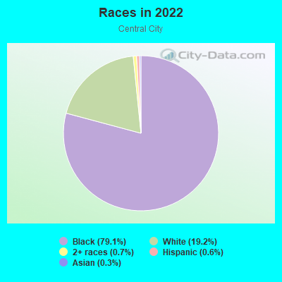
- 2,32379.1%Black
- 56419.2%White
- 210.7%Two or more races
- 180.6%Hispanic or Latino
- 100.3%Asian
Distribution of median household income
![Distribution of median household income]()
- 524Less than $10,000
- 263$10,000 to $19,999
- 94$20,000 to $29,999
- 201$30,000 to $39,999
- 93$40,000 to $49,999
- 16$50,000 to $59,999
- 137$60,000 to $74,999
- 170$75,000 to $99,999
- 96$100,000 to $124,999
- 78$125,000 to $149,999
- 26$150,000 to $199,999
- 71$200,000 or more

Distribution of owner-occupied house/condo value
![Distribution of owner-occupied house/condo value]()
- 82Less than $50,000
- 958$50,000 to $99,999
- 218$100,000 to $149,999
- 12$150,000 to $199,999
- 259$200,000 to $249,999
- 41$250,000 to $299,999
- 26$300,000 to $399,999
- 52$400,000 to $499,999
- 19$500,000 to $749,999
- 45$750,000 to $999,999

Distribution of rent paid by renters
![Distribution of rent paid by renters]()
- 49$200 to $299
- 173$400 to $499
- 114$500 to $599
- 31$600 to $699
- 41$700 to $799
- 20$900 to $999

| Males: | 1,202 |
| Females: | 1,703 |
Males:
| This neighborhood: | 35.7 years |
| Whole city: | 34.5 years |
| This neighborhood: | 65.5 years |
| Whole city: | 35.9 years |
Average household size:
| Central City: | 1.8 people |
| Birmingham: | 27.0 people |
Percentage of family households:
| Central City: | 28.4% |
| Birmingham: | 32.5% |
| Here: | 22.8% |
| Birmingham: | 21.4% |
Percentage of married-couple families with children (among all households):
| Central City: | 18.5% |
| Birmingham: | 14.3% |
Percentage of single-mother households (among all households):
| Central City: | 36.0% |
| Birmingham: | 29.7% |
Percentage of never married males 15 years old and over:
Percentage of never married females 15 years old and over:
| Central City: | 21.0% |
| Birmingham: | 24.0% |
Percentage of never married females 15 years old and over:
| Central City: | 7.0% |
| city: | 26.4% |
Percentage of people born in this state:
Percentage of people born in another U.S. state:
Percentage of native residents but born outside the U.S.:
Percentage of foreign born residents:
| Here: | 82.9% |
| Birmingham: | 76.8% |
Percentage of people born in another U.S. state:
| Central City: | 13.5% |
| Birmingham: | 18.6% |
Percentage of native residents but born outside the U.S.:
| Here: | 1.1% |
| city: | 0.7% |
Percentage of foreign born residents:
| Here: | 2.5% |
| Birmingham: | 3.9% |
Owner-occupied
Renter-occupied

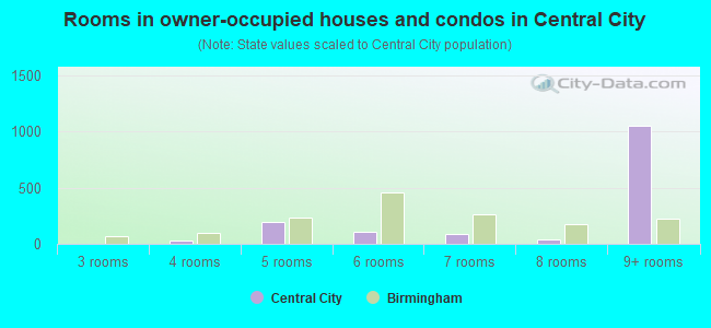
- Rooms in owner-occupied houses and condos in Central City
- 01 room
- 02 rooms
- 03 rooms
- 274 rooms
- 1995 rooms
- 1036 rooms
- 927 rooms
- 408 rooms
- 1,0509+ rooms
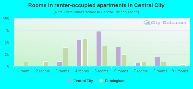
- Rooms in renter-occupied apartments in Central City
- 01 room
- 02 rooms
- 103 rooms
- 554 rooms
- 735 rooms
- 406 rooms
- 77 rooms
- 198 rooms
- 09+ rooms
Owner-occupied
Renter-occupied
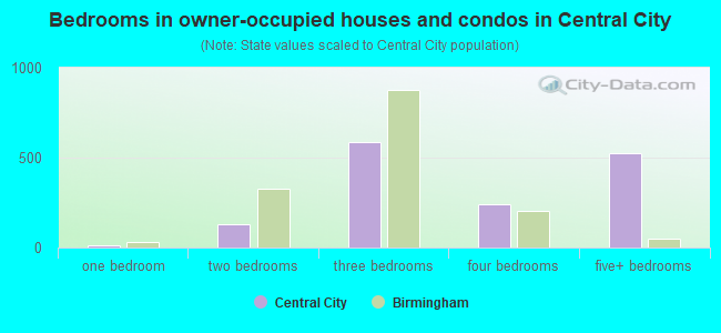
- Bedrooms in owner-occupied houses and condos in Central City
- 0no bedroom
- 121 bedroom
- 1292 bedrooms
- 5893 bedrooms
- 2434 bedrooms
- 5235+ bedrooms
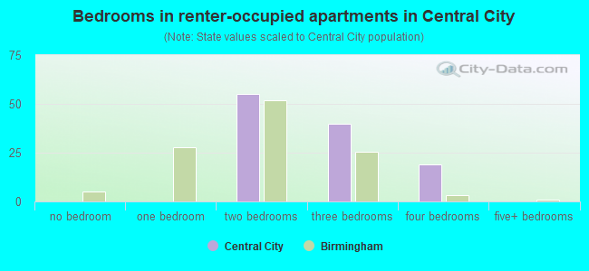
- Bedrooms in renter-occupied apartments in Central City
- 0no bedroom
- 01 bedroom
- 552 bedrooms
- 403 bedrooms
- 194 bedrooms
- 05+ bedrooms
Average number of cars or other vehicles available in houses/condos:
Average number of cars or other vehicles available in apartments:
| This neighborhood: | 0.8 |
| Birmingham: | 1.8 |
Average number of cars or other vehicles available in apartments:
| Here: | 3.0 |
| city: | 1.2 |
Percentage of units with a mortgage:
| Central City: | 45.4% |
| Birmingham: | 51.3% |
Average estimated value of detached houses in 2022 (89.0% of all units):
| Central City: | $148,303 |
| Birmingham: | $180,877 |
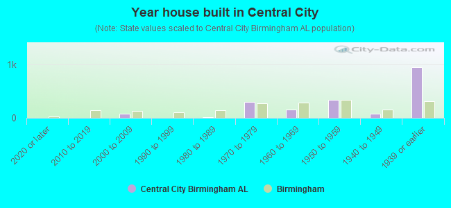
- Year house built in Central City
- 02020 or later
- 02010 to 2019
- 772000 to 2009
- 01990 to 1999
- 181980 to 1989
- 2981970 to 1979
- 1581960 to 1969
- 3391950 to 1959
- 771940 to 1949
- 9471939 or earlier
City-data.com crime index for city in 2020 (higher means more crime):
| City: | 199.5 |
| U.S. average: | 219.5 |
Travel time to work (commute)
![Travel time to work (commute)]()
- 9Less than 5 minutes
- 1335 to 9 minutes
- 16010 to 14 minutes
- 11015 to 19 minutes
- 11420 to 24 minutes
- 11125 to 29 minutes
- 10930 to 34 minutes
- 4040 to 44 minutes
- 2890 or more minutes

Means of transportation to work
![Means of transportation to work]()
- 79.9%1,073Drove a car alone
- 10.1%136Carpooled
- 3.5%47Bus
- 6.3%84Worked at home

Time leaving home to go to work
![Time leaving home to go to work]()
- 7312:00 a.m. to 4:59 a.m.
- 375:00 a.m. to 5:29 a.m.
- 215:30 a.m. to 5:59 a.m.
- 826:00 a.m. to 6:29 a.m.
- 436:30 a.m. to 6:59 a.m.
- 647:00 a.m. to 7:29 a.m.
- 2307:30 a.m. to 7:59 a.m.
- 568:00 a.m. to 8:29 a.m.
- 238:30 a.m. to 8:59 a.m.
- 1479:00 a.m. to 9:59 a.m.
- 2812:00 p.m. to 3:59 p.m.
- 114:00 p.m. to 11:59 p.m.

Occupations of males:
- Percentage of males in management occupations (except farmers):
Here: 8.9% city: 8.1%
- Percentage of males in business and financial operations occupations:
Here: 13.3% city: 4.8%
- Percentage of males in education, training, and library occupations:
Here: 2.8% city: 3.1%
- Percentage of males in service occupations:
Here: 13.9% city: 17.4%
- Percentage of males in sales and office occupations:
Here: 15.6% city: 13.7%
- Percentage of males in construction, extraction, and maintenance occupations:
Here: 567.3% city: 8.3%
- Percentage of males in production occupations:
Here: 5.0% city: 8.0%
- Percentage of males in transportation occupations:
Here: 12.8% city: 6.8%
- Percentage of males in material moving occupations:
Here: 8.3% city: 9.9%
Occupations of females:
- Percentage of females in management occupations (except farmers):
Here: 16.3% city: 8.1%
- Percentage of females in architecture and engineering occupations:
Here: 6.0% city: 0.5%
- Percentage of females in education, training, and library occupations:
Here: 6.5% city: 7.2%
- Percentage of females in healthcare practitioners and technical occupations:
Here: 25.5% city: 10.0%
- Percentage of females in service occupations:
Here: 25.0% city: 22.1%
- Percentage of females in sales and office occupations:
Here: 15.2% city: 28.0%
- Percentage of females in production occupations:
Here: 5.4% city: 4.6%
- Percentage of females in material moving occupations:
Here: 515.3% city: 3.4%
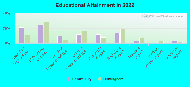
Education in this neighborhood (subdivision or community):
- Percentage of people 3 years and older in K-12 schools:
Central City: 10.6% Birmingham: 13.1%
- Percentage of people 3 years and older in undergraduate colleges:
Central City: 9.0% Birmingham: 7.8%
- Percentage of people 3 years and older in grad. or professional schools:
Central City: 2.7% Birmingham: 2.2%
- Percentage of students K-12 enrolled in private schools:
Central City: 36.2% Birmingham: 11.1%
Percentage of population below poverty level:
| Central City: | 38.7% |
| Birmingham: | 26.6% |
Median year owner moved in (as recorded in 2022):
| Central City: | 2005 |
| Birmingham: | 2004 |
Percentage of married-couple families with both working:
| Central City: | 162.7% |
| Birmingham: | 62.9% |
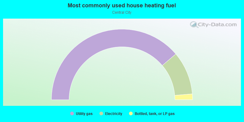
- 77.6%Utility gas
- 19.8%Electricity
- 2.6%Bottled, tank, or LP gas
Limited-access highways (interstate or state) in this neighborhood:
I- 59 (I- 20)
Length: 1.34 miles
Directions: N-S, SW-NE
Directions: N-S, SW-NE
Red Mountain Expy S
Length: 0.33 miles
Directions: E-W, SE-NW, SW-NE
Directions: E-W, SE-NW, SW-NE
Highways in this neighborhood:
8th Ave N (State Rte 4, US Hwy 78)
Length: 1.61 miles
Directions: E-W, SW-NE
Address range: 1900 to 3499
Directions: E-W, SW-NE
Address range: 1900 to 3499
US Hwy 31 (State Rte 3, Red Mountain Expy)
Length: 1.60 miles
Directions: N-S, SE-NW
Directions: N-S, SE-NW
US Hwy 11 (1st Ave N, State Rte 7)
Length: 1.37 miles
Directions: E-W, SE-NW, SW-NE
Address range: 1900 to 3199
Directions: E-W, SE-NW, SW-NE
Address range: 1900 to 3199
26th St N (State Rte 3, US Hwy 31, Carraway Blvd)
Length: 0.99 miles
Directions: N-S, SE-NW, SW-NE
Address range: 100 to 998
Directions: N-S, SE-NW, SW-NE
Address range: 100 to 998
State Rte 4 (US Hwy 78, 24th St N)
Length: 0.81 miles
Direction: SE-NW
Address range: 1 to 899
Direction: SE-NW
Address range: 1 to 899
US Hwy 31 (Red Mountain Expy, State Rte 3, Montgomery Hwy)
Length: 0.03 miles
Direction: SE-NW
Direction: SE-NW
US Hwy 31 (Red Mountain Expy, 26th Way N, State Rte 3)
Length: 0.03 miles
Direction: SE-NW
Direction: SE-NW
Roads and streets:
7th Ave N
Length: 1.50 miles
Directions: E-W, SW-NE
Address range: 1900 to 3299
Directions: E-W, SW-NE
Address range: 1900 to 3299
6th Ave N
Length: 1.39 miles
Directions: N-S, SW-NE
Address range: 1900 to 3299
Directions: N-S, SW-NE
Address range: 1900 to 3299
5th Ave N
Length: 1.22 miles
Directions: E-W, SE-NW, SW-NE
Address range: 1900 to 2799
Directions: E-W, SE-NW, SW-NE
Address range: 1900 to 2799
2nd Ave N
Length: 1.13 miles
Directions: E-W, SW-NE
Address range: 1900 to 2899
Directions: E-W, SW-NE
Address range: 1900 to 2899
Richard Arrington Jr Blvd N
Length: 1.01 miles
Directions: E-W, SE-NW, SW-NE
Address range: 2 to 2798
Directions: E-W, SE-NW, SW-NE
Address range: 2 to 2798
28th St N
Length: 0.98 miles
Direction: SE-NW
Address range: 100 to 1049
Direction: SE-NW
Address range: 100 to 1049
22nd St N
Length: 0.95 miles
Directions: SE-NW, SW-NE
Address range: 1 to 879
Directions: SE-NW, SW-NE
Address range: 1 to 879
3rd Ave N
Length: 0.94 miles
Directions: E-W, N-S, SW-NE
Address range: 1900 to 3099
Directions: E-W, N-S, SW-NE
Address range: 1900 to 3099
20th St N
Length: 0.87 miles
Directions: N-S, SE-NW
Address range: 1 to 899
Directions: N-S, SE-NW
Address range: 1 to 899
23rd St N
Length: 0.77 miles
Direction: SE-NW
Address range: 1 to 879
Direction: SE-NW
Address range: 1 to 879
32nd St N
Length: 0.76 miles
Directions: N-S, SE-NW
Address range: 1 to 199
Directions: N-S, SE-NW
Address range: 1 to 199
19th St N
Length: 0.69 miles
Direction: SE-NW
Address range: 100 to 889
Direction: SE-NW
Address range: 100 to 889
Morris Ave
Length: 0.64 miles
Directions: N-S, SE-NW, SW-NE
Address range: 1900 to 2499
Directions: N-S, SE-NW, SW-NE
Address range: 1900 to 2499
25th St N
Length: 0.62 miles
Direction: SE-NW
Address range: 1 to 949
Direction: SE-NW
Address range: 1 to 949
4th Ave N
Length: 0.58 miles
Directions: E-W, SW-NE
Address range: 1900 to 2799
Directions: E-W, SW-NE
Address range: 1900 to 2799
29th St N
Length: 0.58 miles
Directions: N-S, SE-NW
Address range: 100 to 499
Directions: N-S, SE-NW
Address range: 100 to 499
6th Aly N
Length: 0.54 miles
Directions: E-W, SW-NE
Address range: 2700 to 2799
Directions: E-W, SW-NE
Address range: 2700 to 2799
31st St N
Length: 0.50 miles
Directions: N-S, SE-NW
Address range: 450 to 899
Directions: N-S, SE-NW
Address range: 450 to 899
Airport Hwy (Messer Airport Hwy)
Length: 0.47 miles
Directions: E-W, SW-NE
Address range: 2800 to 3249
Directions: E-W, SW-NE
Address range: 2800 to 3249
5th Ln N
Length: 0.42 miles
Directions: E-W, SW-NE
Address range: 2200 to 2599
Directions: E-W, SW-NE
Address range: 2200 to 2599
6th Ct N
Length: 0.42 miles
Direction: SW-NE
Address range: 2200 to 2599
Direction: SW-NE
Address range: 2200 to 2599
30th St N
Length: 0.40 miles
Direction: SE-NW
Address range: 500 to 899
Direction: SE-NW
Address range: 500 to 899
Messer Airport Aly
Length: 0.38 miles
Directions: E-W, SW-NE
Directions: E-W, SW-NE
Carraway Blvd
Length: 0.32 miles
Directions: E-W, N-S, SE-NW, SW-NE
Directions: E-W, N-S, SE-NW, SW-NE
6th Ter N
Length: 0.32 miles
Directions: E-W, SW-NE
Address range: 2200 to 2599
Directions: E-W, SW-NE
Address range: 2200 to 2599
6th Ln N
Length: 0.32 miles
Directions: E-W, SW-NE
Address range: 2200 to 2599
Directions: E-W, SW-NE
Address range: 2200 to 2599
9th Ave N
Length: 0.29 miles
Direction: SW-NE
Direction: SW-NE
8th Aly N
Length: 0.26 miles
Directions: E-W, SW-NE
Address range: 2052 to 2103
Directions: E-W, SW-NE
Address range: 2052 to 2103
8th Ct N
Length: 0.23 miles
Directions: E-W, SW-NE
Address range: 2500 to 2699
Directions: E-W, SW-NE
Address range: 2500 to 2699
5th Ter N
Length: 0.21 miles
Direction: SW-NE
Address range: 2400 to 2599
Direction: SW-NE
Address range: 2400 to 2599
5th Ct N
Length: 0.21 miles
Direction: SW-NE
Address range: 2400 to 2599
Direction: SW-NE
Address range: 2400 to 2599
7th Aly N
Length: 0.20 miles
Direction: SW-NE
Address range: 2600 to 2699
Direction: SW-NE
Address range: 2600 to 2699
Railroad Ave
Length: 0.18 miles
Direction: SW-NE
Direction: SW-NE
Park Pl
Length: 0.15 miles
Direction: SW-NE
Address range: 1901 to 2199
Direction: SW-NE
Address range: 1901 to 2199
29th St
Length: 0.14 miles
Direction: SE-NW
Direction: SE-NW
34th St N
Length: 0.11 miles
Directions: N-S, SE-NW
Address range: 800 to 899
Directions: N-S, SE-NW
Address range: 800 to 899
7th Ter N
Length: 0.11 miles
Direction: SW-NE
Address range: 2200 to 2299
Direction: SW-NE
Address range: 2200 to 2299
7th Ct N
Length: 0.11 miles
Direction: SW-NE
Address range: 2200 to 2299
Direction: SW-NE
Address range: 2200 to 2299
7th Ln N
Length: 0.10 miles
Direction: SW-NE
Address range: 2200 to 2299
Direction: SW-NE
Address range: 2200 to 2299
9th Aly
Length: 0.10 miles
Direction: SW-NE
Direction: SW-NE
3rd Aly N
Length: 0.10 miles
Direction: SW-NE
Address range: 2300 to 2399
Direction: SW-NE
Address range: 2300 to 2399
2nd Aly
Length: 0.09 miles
Direction: SW-NE
Direction: SW-NE
33rd St N
Length: 0.08 miles
Directions: E-W, SE-NW
Directions: E-W, SE-NW
29th Pl N
Length: 0.06 miles
Direction: SE-NW
Address range: 800 to 899
Direction: SE-NW
Address range: 800 to 899
9th Ave
Length: 0.06 miles
Direction: SW-NE
Direction: SW-NE
2nd Aly N
Length: 0.06 miles
Direction: SW-NE
Direction: SW-NE
29th St S
Length: 0.05 miles
Direction: SE-NW
Direction: SE-NW
27th Pl N
Length: 0.05 miles
Direction: SE-NW
Address range: 300 to 499
Direction: SE-NW
Address range: 300 to 499
1st Aly N
Length: 0.03 miles
Direction: SW-NE
Direction: SW-NE
Railroad features:
Louisville and Nashville RR
Length: 1.75 miles
Directions: E-W, N-S, SW-NE
Directions: E-W, N-S, SW-NE
Southern Rlwy
Length: 1.41 miles
Directions: E-W, N-S, SE-NW
Directions: E-W, N-S, SE-NW
Central of Georgia RR
Length: 1.33 miles
Directions: E-W, SE-NW, SW-NE
Directions: E-W, SE-NW, SW-NE
Alabama Great Southern RR
Length: 0.73 miles
Directions: E-W, SW-NE
Directions: E-W, SW-NE
St Louis-San Francisco Rlwy
Length: 0.21 miles
Direction: SW-NE
Direction: SW-NE
Belt RR
Length: 0.17 miles
Directions: E-W, SE-NW
Directions: E-W, SE-NW