Downtown neighborhood in Akron, Ohio (OH), 44307, 44308, 44311, 44301, 44302 detailed profile
Settings
X


Business Search - 14 Million verified businesses
Area: 1.794 square miles
Population: 5,350
Population density:
| Downtown: | 2,983 people per square mile |
| Akron: | 3,037 people per square mile |

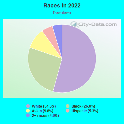
- 2,60348.5%Black
- 2,27942.5%White
- 1843.4%Hispanic or Latino
- 1743.2%Two or more races
- 731.4%Asian
- 400.7%Some other race
- 130.2%American Indian

Distribution of median household income
![Distribution of median household income]()
- 544Less than $10,000
- 952$10,000 to $19,999
- 277$20,000 to $29,999
- 149$30,000 to $39,999
- 163$40,000 to $49,999
- 436$50,000 to $59,999
- 110$60,000 to $74,999
- 29$75,000 to $99,999
- 55$100,000 to $124,999
- 80$125,000 to $149,999
- 120$150,000 to $199,999
- 36$200,000 or more

Distribution of owner-occupied house/condo value
![Distribution of owner-occupied house/condo value]()
- 713Less than $50,000
- 1,026$50,000 to $99,999
- 925$100,000 to $149,999
- 271$150,000 to $199,999
- 397$200,000 to $249,999
- 43$250,000 to $299,999
- 52$300,000 to $399,999
- 9$400,000 to $499,999
- 300$500,000 to $749,999

Distribution of rent paid by renters
![Distribution of rent paid by renters]()
- 119Less than $100
- 235$100 to $199
- 513$200 to $299
- 91$300 to $399
- 221$400 to $499
- 64$500 to $599
- 621$600 to $699
- 372$700 to $799
- 24$800 to $899
- 10$900 to $999
- 311$1,000 to $1,249
- 120$1,250 to $1,499
- 96$1,500 to $1,999
- 87$2,000 or more

Median rent in 2022:
| Downtown: | $513 |
| Akron: | $721 |
| Males: | 2,915 |
| Females: | 2,434 |
Males:
| This neighborhood: | 32.1 years |
| Whole city: | 34.8 years |
| This neighborhood: | 38.3 years |
| Whole city: | 38.2 years |
Average household size:
| Downtown: | 2.1 people |
| Akron: | 2.2 people |
Percentage of family households:
| Downtown: | 27.1% |
| Akron: | 39.9% |
| Here: | 7.6% |
| Akron: | 27.3% |
Percentage of married-couple families with children (among all households):
| Downtown: | 19.9% |
| Akron: | 16.8% |
Percentage of single-mother households (among all households):
| Downtown: | 173.1% |
| Akron: | 23.1% |
Percentage of never married males 15 years old and over:
Percentage of never married females 15 years old and over:
| Downtown: | 37.0% |
| Akron: | 23.2% |
Percentage of never married females 15 years old and over:
| Downtown: | 26.2% |
| city: | 22.0% |
Percentage of people that speak English not well or not at all:
| Downtown: | 0.2% |
| Akron: | 2.5% |
Percentage of people born in this state:
Percentage of people born in another U.S. state:
Percentage of native residents but born outside the U.S.:
Percentage of foreign born residents:
| Here: | 76.5% |
| Akron: | 76.3% |
Percentage of people born in another U.S. state:
| Downtown: | 19.6% |
| Akron: | 18.6% |
Percentage of native residents but born outside the U.S.:
| Here: | 0.9% |
| city: | 0.7% |
Percentage of foreign born residents:
| Here: | 3.0% |
| Akron: | 4.4% |
Owner-occupied
Renter-occupied

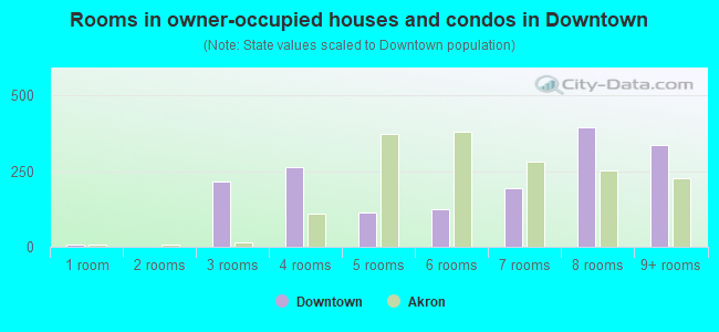
- Rooms in owner-occupied houses and condos in Downtown
- 91 room
- 02 rooms
- 2163 rooms
- 2654 rooms
- 1125 rooms
- 1246 rooms
- 1937 rooms
- 3958 rooms
- 3379+ rooms
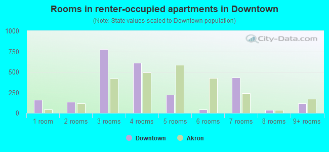
- Rooms in renter-occupied apartments in Downtown
- 1621 room
- 1352 rooms
- 7753 rooms
- 6094 rooms
- 2225 rooms
- 446 rooms
- 4357 rooms
- 358 rooms
- 1179+ rooms
Owner-occupied
Renter-occupied
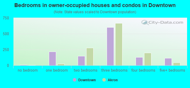
- Bedrooms in owner-occupied houses and condos in Downtown
- 9no bedroom
- 2161 bedroom
- 1482 bedrooms
- 6023 bedrooms
- 1284 bedrooms
- 1155+ bedrooms
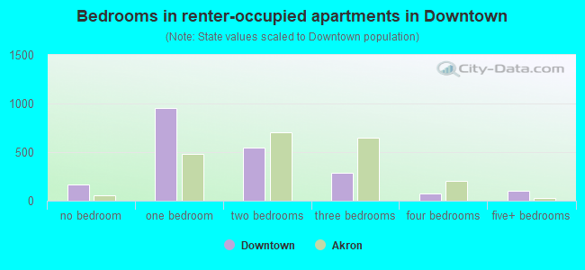
- Bedrooms in renter-occupied apartments in Downtown
- 163no bedroom
- 9531 bedroom
- 5442 bedrooms
- 2843 bedrooms
- 724 bedrooms
- 1065+ bedrooms
Average number of cars or other vehicles available in houses/condos:
Average number of cars or other vehicles available in apartments:
| This neighborhood: | 9.2 |
| Akron: | 1.7 |
Average number of cars or other vehicles available in apartments:
| Here: | 3.1 |
| city: | 1.1 |
Percentage of units with a mortgage:
| Downtown: | 88.1% |
| Akron: | 55.4% |
Average estimated value of detached houses in 2022 (8.2% of all units):
| Downtown: | $80,241 |
| Ohio: | $254,366 |
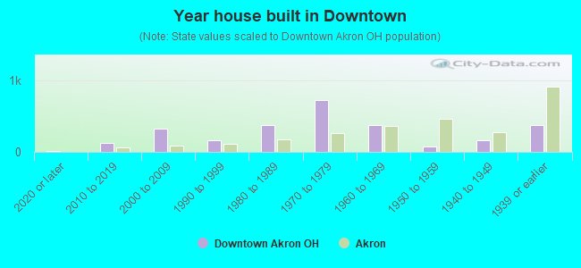
- Year house built in Downtown
- 162020 or later
- 1192010 to 2019
- 3222000 to 2009
- 1581990 to 1999
- 3771980 to 1989
- 7281970 to 1979
- 3811960 to 1969
- 811950 to 1959
- 1661940 to 1949
- 3751939 or earlier
City-data.com crime index for city in 2020 (higher means more crime):
| City: | 481.4 |
| U.S. average: | 219.5 |
Travel time to work (commute)
![Travel time to work (commute)]()
- 70Less than 5 minutes
- 1635 to 9 minutes
- 31410 to 14 minutes
- 36315 to 19 minutes
- 23320 to 24 minutes
- 7125 to 29 minutes
- 12130 to 34 minutes
- 7135 to 39 minutes
- 1440 to 44 minutes
- 7845 to 59 minutes
- 4460 to 89 minutes
- 990 or more minutes

Means of transportation to work
![Means of transportation to work]()
- 60.5%1,012Drove a car alone
- 15.8%264Carpooled
- 7.5%125Bus
- 8.0%134Taxi
- 20.3%339Bicycle
- 12.1%202Walked
- 0.9%15Other means
- 5.7%95Worked at home

Time leaving home to go to work
![Time leaving home to go to work]()
- 2812:00 a.m. to 4:59 a.m.
- 2365:00 a.m. to 5:29 a.m.
- 255:30 a.m. to 5:59 a.m.
- 506:00 a.m. to 6:29 a.m.
- 2386:30 a.m. to 6:59 a.m.
- 1587:00 a.m. to 7:29 a.m.
- 1527:30 a.m. to 7:59 a.m.
- 1208:00 a.m. to 8:29 a.m.
- 1148:30 a.m. to 8:59 a.m.
- 289:00 a.m. to 9:59 a.m.
- 3310:00 a.m. to 10:59 a.m.
- 2111:00 a.m. to 11:59 a.m.
- 21312:00 p.m. to 3:59 p.m.
- 2804:00 p.m. to 11:59 p.m.

Occupations of males:
- Percentage of males in management occupations (except farmers):
Here: 8.8% city: 7.7%
- Percentage of males in business and financial operations occupations:
Here: 1.5% city: 3.7%
- Percentage of males in computer and mathematical occupations:
Here: 2.3% city: 3.1%
- Percentage of males in community and social services occupations:
Here: 2.1% city: 1.3%
- Percentage of males in legal occupations:
Here: 1.5% city: 0.7%
- Percentage of males in education, training, and library occupations:
Here: 6.6% city: 2.7%
- Percentage of males in service occupations:
Here: 29.8% city: 17.1%
- Percentage of males in sales and office occupations:
Here: 18.1% city: 14.8%
- Percentage of males in construction, extraction, and maintenance occupations:
Here: 11.5% city: 7.5%
- Percentage of males in production occupations:
Here: 8.1% city: 13.5%
- Percentage of males in transportation occupations:
Here: 3.5% city: 5.5%
- Percentage of males in material moving occupations:
Here: 3.0% city: 9.4%
Occupations of females:
- Percentage of females in management occupations (except farmers):
Here: 15.1% city: 7.5%
- Percentage of females in computer and mathematical occupations:
Here: 2.6% city: 1.2%
- Percentage of females in architecture and engineering occupations:
Here: 2.7% city: 0.4%
- Percentage of females in education, training, and library occupations:
Here: 19.5% city: 6.7%
- Percentage of females in service occupations:
Here: 26.6% city: 26.6%
- Percentage of females in sales and office occupations:
Here: 19.8% city: 28.8%
- Percentage of females in production occupations:
Here: 8.1% city: 4.5%
- Percentage of females in transportation occupations:
Here: 3.1% city: 1.6%
- Percentage of females in material moving occupations:
Here: 2.3% city: 3.4%
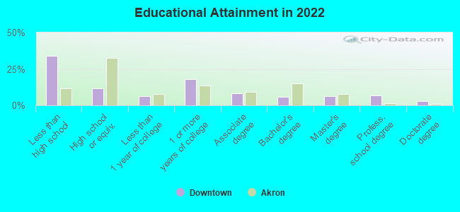
Education in this neighborhood (subdivision or community):
- Percentage of people 3 years and older in K-12 schools:
Downtown: 47.3% Akron: 17.3%
- Percentage of people 3 years and older in undergraduate colleges:
Downtown: 15.3% Akron: 5.4%
- Percentage of people 3 years and older in grad. or professional schools:
Downtown: 2.0% Akron: 1.2%
- Percentage of students K-12 enrolled in private schools:
Downtown: 77.4% Akron: 11.4%
Percentage of population below poverty level:
| Downtown: | 44.3% |
| Akron: | 24.4% |
Median year renter moved in (as recorded in 2022):
| Downtown: | 2016 |
| Akron: | 2019 |
Percentage of married-couple families with both working:
| Downtown: | 603.3% |
| Akron: | 67.4% |
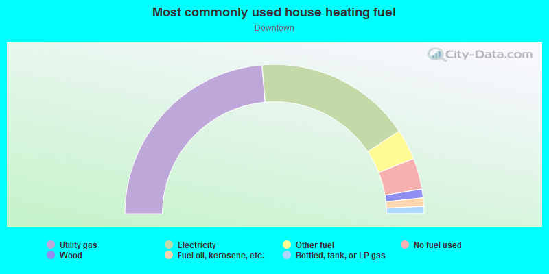
- 47.4%Utility gas
- 34.0%Electricity
- 6.7%Other fuel
- 6.7%No fuel used
- 1.9%Wood
- 1.8%Fuel oil, kerosene, etc.
- 1.6%Bottled, tank, or LP gas
Limited-access highways (interstate or state) in this neighborhood:
I- 76 (I- 77)
Length: 1.05 miles
Direction: E-W
Direction: E-W
Highways in this neighborhood:
State Rte 59 (Martin Luther King Blvd, Innerbelt)
Length: 1.49 miles
Directions: E-W, N-S, SW-NE
Address range: 120 to 139
Directions: E-W, N-S, SW-NE
Address range: 120 to 139
State Rte 261 (W Bowery St)
Length: 0.83 miles
Directions: E-W, SW-NE
Address range: 1 to 399
Directions: E-W, SW-NE
Address range: 1 to 399
S Maple St (State Rte 162)
Length: 0.66 miles
Direction: E-W
Address range: 61 to 358
Direction: E-W
Address range: 61 to 358
State Rte 18 (E Market St)
Length: 0.58 miles
Directions: E-W, SE-NW
Address range: 1 to 249
Directions: E-W, SE-NW
Address range: 1 to 249
State Rte 162 (Glendale Ave)
Length: 0.55 miles
Directions: E-W, SE-NW
Address range: 1 to 299
Directions: E-W, SE-NW
Address range: 1 to 299
State Rte 261 (Opportunity Pkwy)
Length: 0.51 miles
Directions: E-W, SW-NE
Address range: 1 to 349
Directions: E-W, SW-NE
Address range: 1 to 349
State Rte 18 (W Market St)
Length: 0.34 miles
Directions: E-W, SE-NW
Address range: 17 to 145
Directions: E-W, SE-NW
Address range: 17 to 145
State Rte 261 (N Main St)
Length: 0.07 miles
Directions: N-S, SW-NE
Address range: 1 to 37
Directions: N-S, SW-NE
Address range: 1 to 37
Roads and streets:
S Main St
Length: 1.78 miles
Directions: N-S, SW-NE
Address range: 1 to 1205
Directions: N-S, SW-NE
Address range: 1 to 1205
S Broadway St
Length: 1.74 miles
Directions: N-S, SW-NE
Address range: 1 to 879
Directions: N-S, SW-NE
Address range: 1 to 879
S High St
Length: 1.28 miles
Directions: N-S, SW-NE
Address range: 1 to 698
Directions: N-S, SW-NE
Address range: 1 to 698
Dart Ave
Length: 1.10 miles
Directions: E-W, N-S, SE-NW, SW-NE
Directions: E-W, N-S, SE-NW, SW-NE
Sweitzer Ave
Length: 0.88 miles
Directions: N-S, SW-NE
Address range: 576 to 1195
Directions: N-S, SW-NE
Address range: 576 to 1195
Rand St
Length: 0.75 miles
Directions: E-W, SW-NE
Address range: 74 to 229
Directions: E-W, SW-NE
Address range: 74 to 229
Miami St
Length: 0.73 miles
Directions: E-W, N-S, SW-NE
Address range: 500 to 970
Directions: E-W, N-S, SW-NE
Address range: 500 to 970
Locust St
Length: 0.72 miles
Directions: N-S, SW-NE
Address range: 1 to 509
Directions: N-S, SW-NE
Address range: 1 to 509
Steiner Ave
Length: 0.71 miles
Direction: E-W
Address range: 1 to 299
Direction: E-W
Address range: 1 to 299
W Thornton St
Length: 0.70 miles
Direction: E-W
Address range: 44 to 269
Direction: E-W
Address range: 44 to 269
W Cedar St
Length: 0.69 miles
Directions: E-W, SE-NW
Address range: 20 to 289
Directions: E-W, SE-NW
Address range: 20 to 289
Water St
Length: 0.68 miles
Directions: E-W, N-S, SE-NW, SW-NE
Address range: 190 to 514
Directions: E-W, N-S, SE-NW, SW-NE
Address range: 190 to 514
Wabash Ave
Length: 0.66 miles
Directions: E-W, N-S, SE-NW, SW-NE
Address range: 230 to 667
Directions: E-W, N-S, SE-NW, SW-NE
Address range: 230 to 667
Maiden Ln
Length: 0.66 miles
Direction: SW-NE
Address range: 1 to 339
Direction: SW-NE
Address range: 1 to 339
W Bartges St
Length: 0.65 miles
Direction: E-W
Address range: 1 to 299
Direction: E-W
Address range: 1 to 299
Bellows St
Length: 0.60 miles
Direction: N-S
Address range: 700 to 1089
Direction: N-S
Address range: 700 to 1089
E Voris St
Length: 0.59 miles
Direction: E-W
Address range: 1 to 244
Direction: E-W
Address range: 1 to 244
W Exchange St
Length: 0.58 miles
Directions: E-W, SE-NW
Address range: 1 to 286
Directions: E-W, SE-NW
Address range: 1 to 286
E Thornton St
Length: 0.56 miles
Direction: E-W
Address range: 1 to 223
Direction: E-W
Address range: 1 to 223
Wolf Ledges Pkwy
Length: 0.56 miles
Directions: N-S, SE-NW
Address range: 522 to 799
Directions: N-S, SE-NW
Address range: 522 to 799
E Miller Ave
Length: 0.53 miles
Direction: E-W
Address range: 51 to 259
Direction: E-W
Address range: 51 to 259
E South St
Length: 0.49 miles
Direction: E-W
Address range: 66 to 259
Direction: E-W
Address range: 66 to 259
W State St
Length: 0.42 miles
Directions: E-W, SE-NW
Address range: 1 to 176
Directions: E-W, SE-NW
Address range: 1 to 176
E Crosier St
Length: 0.41 miles
Direction: E-W
Address range: 80 to 249
Direction: E-W
Address range: 80 to 249
W Falor St
Length: 0.39 miles
Directions: E-W, SE-NW
Address range: 100 to 169
Directions: E-W, SE-NW
Address range: 100 to 169
W Center St
Length: 0.38 miles
Directions: E-W, N-S, SE-NW, SW-NE
Address range: 8 to 299
Directions: E-W, N-S, SE-NW, SW-NE
Address range: 8 to 299
E Mill St
Length: 0.36 miles
Directions: E-W, SE-NW
Address range: 1 to 172
Directions: E-W, SE-NW
Address range: 1 to 172
la Salle Dr
Length: 0.33 miles
Directions: E-W, N-S, SE-NW, SW-NE
Directions: E-W, N-S, SE-NW, SW-NE
Wooster Ave
Length: 0.30 miles
Directions: E-W, SE-NW
Address range: 100 to 217
Directions: E-W, SE-NW
Address range: 100 to 217
Wheeler Ln
Length: 0.30 miles
Directions: N-S, SW-NE
Address range: 11 to 349
Directions: N-S, SW-NE
Address range: 11 to 349
Journal Aly
Length: 0.29 miles
Directions: E-W, SE-NW
Address range: 100 to 179
Directions: E-W, SE-NW
Address range: 100 to 179
Wills Ave
Length: 0.27 miles
Directions: E-W, N-S, SW-NE
Address range: 100 to 231
Directions: E-W, N-S, SW-NE
Address range: 100 to 231
E Bowery St
Length: 0.26 miles
Directions: E-W, SE-NW
Address range: 1 to 99
Directions: E-W, SE-NW
Address range: 1 to 99
University Ave
Length: 0.26 miles
Directions: E-W, SE-NW
Address range: 1 to 92
Directions: E-W, SE-NW
Address range: 1 to 92
Ash St
Length: 0.24 miles
Directions: E-W, SW-NE
Directions: E-W, SW-NE
McCoy St
Length: 0.23 miles
Direction: E-W
Address range: 160 to 250
Direction: E-W
Address range: 160 to 250
W Buchtel Ave
Length: 0.23 miles
Directions: E-W, SE-NW
Address range: 1 to 199
Directions: E-W, SE-NW
Address range: 1 to 199
Gregory Ave
Length: 0.22 miles
Direction: E-W
Address range: 29 to 120
Direction: E-W
Address range: 29 to 120
Furnace Run Dr (Furnace Run Rd)
Length: 0.22 miles
Directions: E-W, N-S, SE-NW, SW-NE
Address range: 78 to 144
Directions: E-W, N-S, SE-NW, SW-NE
Address range: 78 to 144
N Summit St
Length: 0.20 miles
Direction: SW-NE
Address range: 1 to 99
Direction: SW-NE
Address range: 1 to 99
W Mill St
Length: 0.20 miles
Directions: E-W, SE-NW
Address range: 1 to 29
Directions: E-W, SE-NW
Address range: 1 to 29
First Merit Cir
Length: 0.20 miles
Direction: E-W
Address range: 200 to 299
Direction: E-W
Address range: 200 to 299
Oak Park Dr
Length: 0.19 miles
Directions: E-W, N-S, SW-NE
Address range: 100 to 199
Directions: E-W, N-S, SW-NE
Address range: 100 to 199
Abel St
Length: 0.19 miles
Direction: E-W
Address range: 224 to 265
Direction: E-W
Address range: 224 to 265
Pier Dr
Length: 0.19 miles
Direction: N-S
Address range: 800 to 899
Direction: N-S
Address range: 800 to 899
Pine St
Length: 0.19 miles
Direction: SW-NE
Address range: 300 to 479
Direction: SW-NE
Address range: 300 to 479
Getz St
Length: 0.19 miles
Direction: N-S
Address range: 1100 to 1219
Direction: N-S
Address range: 1100 to 1219
E State St
Length: 0.18 miles
Direction: E-W
Address range: 1 to 72
Direction: E-W
Address range: 1 to 72
Aspen St
Length: 0.18 miles
Directions: E-W, SE-NW, SW-NE
Address range: 2 to 299
Directions: E-W, SE-NW, SW-NE
Address range: 2 to 299
E Buchtel Ave
Length: 0.18 miles
Directions: E-W, SE-NW
Address range: 1 to 99
Directions: E-W, SE-NW
Address range: 1 to 99
E Exchange St
Length: 0.18 miles
Directions: E-W, SE-NW
Address range: 1 to 73
Directions: E-W, SE-NW
Address range: 1 to 73
E Cedar St
Length: 0.18 miles
Directions: E-W, SE-NW
Address range: 1 to 69
Directions: E-W, SE-NW
Address range: 1 to 69
Selle St
Length: 0.18 miles
Directions: E-W, SE-NW
Address range: 1 to 96
Directions: E-W, SE-NW
Address range: 1 to 96
S Summit St
Length: 0.17 miles
Direction: SW-NE
Address range: 1 to 99
Direction: SW-NE
Address range: 1 to 99
Park St
Length: 0.16 miles
Directions: E-W, SE-NW
Address range: 180 to 225
Directions: E-W, SE-NW
Address range: 180 to 225
Livingston St
Length: 0.16 miles
Direction: SW-NE
Address range: 366 to 452
Direction: SW-NE
Address range: 366 to 452
S Highbrook St
Length: 0.16 miles
Directions: N-S, SW-NE
Address range: 1129 to 1207
Directions: N-S, SW-NE
Address range: 1129 to 1207
E Bartges St
Length: 0.16 miles
Direction: E-W
Address range: 1 to 79
Direction: E-W
Address range: 1 to 79
Fleming Dr
Length: 0.16 miles
Directions: E-W, N-S, SW-NE
Address range: 600 to 799
Directions: E-W, N-S, SW-NE
Address range: 600 to 799
Dorothy O Jackson Ter
Length: 0.15 miles
Directions: E-W, N-S, SW-NE
Directions: E-W, N-S, SW-NE
Callis Dr
Length: 0.14 miles
Directions: N-S, SW-NE
Directions: N-S, SW-NE
Perfida Pl
Length: 0.14 miles
Directions: N-S, SW-NE
Address range: 18 to 99
Directions: N-S, SW-NE
Address range: 18 to 99
Andrus St
Length: 0.14 miles
Direction: N-S
Address range: 1100 to 1193
Direction: N-S
Address range: 1100 to 1193
Marcy St
Length: 0.14 miles
Direction: N-S
Address range: 1100 to 1199
Direction: N-S
Address range: 1100 to 1199
Spring St
Length: 0.13 miles
Directions: E-W, SE-NW
Address range: 1 to 53
Directions: E-W, SE-NW
Address range: 1 to 53
Gault St
Length: 0.13 miles
Directions: E-W, SW-NE
Address range: 159 to 240
Directions: E-W, SW-NE
Address range: 159 to 240
Morning Star Dr
Length: 0.13 miles
Directions: E-W, N-S, SE-NW, SW-NE
Address range: 912 to 972
Directions: E-W, N-S, SE-NW, SW-NE
Address range: 912 to 972
King Dr
Length: 0.12 miles
Directions: N-S, SW-NE
Address range: 100 to 299
Directions: N-S, SW-NE
Address range: 100 to 299
Cole Pl
Length: 0.12 miles
Direction: E-W
Address range: 1 to 199
Direction: E-W
Address range: 1 to 199
S Prospect St
Length: 0.12 miles
Direction: SW-NE
Address range: 1 to 99
Direction: SW-NE
Address range: 1 to 99
S Walnut St
Length: 0.12 miles
Directions: N-S, SW-NE
Address range: 1 to 68
Directions: N-S, SW-NE
Address range: 1 to 68
Cascade Mills Dr
Length: 0.11 miles
Directions: E-W, N-S, SE-NW
Address range: 700 to 899
Directions: E-W, N-S, SE-NW
Address range: 700 to 899
Cross St
Length: 0.11 miles
Direction: E-W
Address range: 100 to 159
Direction: E-W
Address range: 100 to 159
Dunbar Dr
Length: 0.11 miles
Directions: N-S, SE-NW, SW-NE
Address range: 700 to 755
Directions: N-S, SE-NW, SW-NE
Address range: 700 to 755
Callis Oval
Length: 0.11 miles
Directions: E-W, N-S, SE-NW, SW-NE
Address range: 669 to 799
Directions: E-W, N-S, SE-NW, SW-NE
Address range: 669 to 799
S Bates St
Length: 0.11 miles
Directions: N-S, SE-NW, SW-NE
Address range: 1 to 79
Directions: N-S, SE-NW, SW-NE
Address range: 1 to 79
Palmyra Ave
Length: 0.10 miles
Direction: E-W
Address range: 160 to 191
Direction: E-W
Address range: 160 to 191
Grant St
Length: 0.10 miles
Direction: N-S
Address range: 716 to 765
Direction: N-S
Address range: 716 to 765
Limestone Aly
Length: 0.10 miles
Direction: SW-NE
Address range: 380 to 429
Direction: SW-NE
Address range: 380 to 429
Quaker St
Length: 0.10 miles
Directions: N-S, SE-NW
Address range: 130 to 189
Directions: N-S, SE-NW
Address range: 130 to 189
Basin Ter
Length: 0.09 miles
Direction: E-W
Address range: 100 to 149
Direction: E-W
Address range: 100 to 149
St Clair Dr
Length: 0.09 miles
Directions: E-W, SW-NE
Address range: 168 to 214
Directions: E-W, SW-NE
Address range: 168 to 214
Orleans Ave
Length: 0.09 miles
Direction: SW-NE
Address range: 300 to 399
Direction: SW-NE
Address range: 300 to 399
Church St
Length: 0.09 miles
Direction: SE-NW
Address range: 1 to 35
Direction: SE-NW
Address range: 1 to 35
W Chestnut St
Length: 0.09 miles
Direction: E-W
Address range: 100 to 206
Direction: E-W
Address range: 100 to 206
Pleasant Pl
Length: 0.09 miles
Direction: N-S
Address range: 590 to 650
Direction: N-S
Address range: 590 to 650
N Prospect St
Length: 0.08 miles
Direction: SW-NE
Address range: 19 to 48
Direction: SW-NE
Address range: 19 to 48
Goodrich Ave
Length: 0.08 miles
Directions: N-S, SE-NW
Directions: N-S, SE-NW
Tate Ter
Length: 0.08 miles
Direction: E-W
Address range: 100 to 149
Direction: E-W
Address range: 100 to 149
N High St
Length: 0.08 miles
Direction: SW-NE
Address range: 1 to 39
Direction: SW-NE
Address range: 1 to 39
Calico Dr
Length: 0.07 miles
Directions: E-W, SW-NE
Address range: 200 to 299
Directions: E-W, SW-NE
Address range: 200 to 299
Dawes Ave
Length: 0.07 miles
Direction: N-S
Address range: 87 to 140
Direction: N-S
Address range: 87 to 140
Jeanette Ave (Jeanette Ct)
Length: 0.07 miles
Direction: SE-NW
Address range: 42 to 299
Direction: SE-NW
Address range: 42 to 299
Oviatt Pl
Length: 0.07 miles
Directions: E-W, SW-NE
Address range: 1 to 119
Directions: E-W, SW-NE
Address range: 1 to 119
Quarry Dr
Length: 0.07 miles
Directions: N-S, SE-NW, SW-NE
Address range: 800 to 999
Directions: N-S, SE-NW, SW-NE
Address range: 800 to 999
Trimble Dr
Length: 0.07 miles
Directions: E-W, N-S, SE-NW, SW-NE
Address range: 900 to 999
Directions: E-W, N-S, SE-NW, SW-NE
Address range: 900 to 999
Curtis St
Length: 0.06 miles
Direction: N-S
Address range: 1190 to 1213
Direction: N-S
Address range: 1190 to 1213
Cascade Plz
Length: 0.06 miles
Direction: E-W
Address range: 1 to 99
Direction: E-W
Address range: 1 to 99
Star St
Length: 0.06 miles
Directions: N-S, SW-NE
Address range: 888 to 919
Directions: N-S, SW-NE
Address range: 888 to 919
Lock Tender Dr
Length: 0.06 miles
Direction: N-S
Direction: N-S
Adeline St
Length: 0.05 miles
Directions: E-W, N-S
Address range: 800 to 841
Directions: E-W, N-S
Address range: 800 to 841
Washington St
Length: 0.05 miles
Directions: N-S, SW-NE
Address range: 810 to 843
Directions: N-S, SW-NE
Address range: 810 to 843
St Ambrose Dr
Length: 0.05 miles
Directions: N-S, SE-NW, SW-NE
Address range: 800 to 999
Directions: N-S, SE-NW, SW-NE
Address range: 800 to 999
Bell St
Length: 0.05 miles
Direction: N-S
Address range: 700 to 799
Direction: N-S
Address range: 700 to 799
Ogle Ter
Length: 0.05 miles
Direction: E-W
Address range: 150 to 199
Direction: E-W
Address range: 150 to 199
Wicket Dr
Length: 0.05 miles
Direction: SE-NW
Address range: 800 to 999
Direction: SE-NW
Address range: 800 to 999
Firestone Pkwy
Length: 0.05 miles
Direction: SW-NE
Address range: 1180 to 1189
Direction: SW-NE
Address range: 1180 to 1189
Wybell Ct
Length: 0.05 miles
Direction: N-S
Address range: 100 to 199
Direction: N-S
Address range: 100 to 199
Tandy Ln
Length: 0.04 miles
Direction: E-W
Address range: 100 to 149
Direction: E-W
Address range: 100 to 149
N Broadway St
Length: 0.04 miles
Direction: SW-NE
Direction: SW-NE
Van Ct
Length: 0.04 miles
Direction: SW-NE
Address range: 350 to 459
Direction: SW-NE
Address range: 350 to 459
Walnut Ter
Length: 0.04 miles
Direction: E-W
Address range: 100 to 199
Direction: E-W
Address range: 100 to 199
Botzum Ct
Length: 0.04 miles
Direction: E-W
Address range: 59 to 199
Direction: E-W
Address range: 59 to 199
Wesley Pl
Length: 0.03 miles
Direction: N-S
Address range: 150 to 199
Direction: N-S
Address range: 150 to 199
Perkins Sq
Length: 0.03 miles
Direction: SE-NW
Address range: 1 to 7
Direction: SE-NW
Address range: 1 to 7
Christie St
Length: 0.03 miles
Directions: N-S, SW-NE
Address range: 1 to 99
Directions: N-S, SW-NE
Address range: 1 to 99
Railroad features:
Csx RR
Length: 1.58 miles
Directions: N-S, SW-NE
Directions: N-S, SW-NE
Akron and Barberton Belt RR
Length: 0.63 miles
Directions: E-W, SE-NW, SW-NE
Directions: E-W, SE-NW, SW-NE
Other features:
Ohio Cnl
Length: 1.62 miles
Directions: E-W, N-S, SW-NE
Directions: E-W, N-S, SW-NE