Enclave at Spanos Park East neighborhood in Stockton, California (CA), 95209, 95219 detailed profile
Settings
X


Business Search - 14 Million verified businesses
Area: 2.353 square miles
Population: 791
Population density:
| Enclave at Spanos Park East: | 336 people per square mile |
| Stockton: | 5,882 people per square mile |

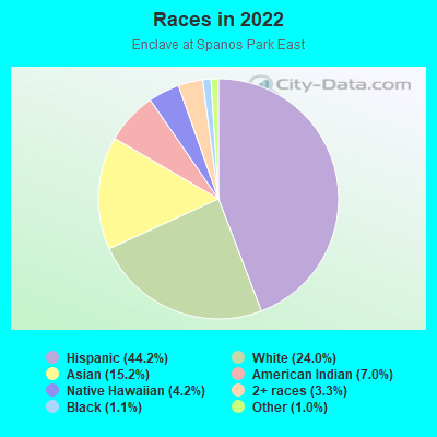
- 38944.2%Hispanic or Latino
- 21124.0%White
- 13415.2%Asian
- 627.0%American Indian
- 374.2%Native Hawaiian and Other
Pacific Islander - 293.3%Two or more races
- 101.1%Black
- 91.0%Some other race
Median household income in 2022:
| Enclave at Spanos Park East: | $77,949 |
| Stockton: | $76,231 |
Distribution of median household income
![Distribution of median household income]()
- 1Less than $10,000
- 9$10,000 to $19,999
- 7$20,000 to $29,999
- 10$30,000 to $39,999
- 6$40,000 to $49,999
- 19$50,000 to $59,999
- 22$60,000 to $74,999
- 43$75,000 to $99,999
- 567$100,000 to $124,999
- 19$125,000 to $149,999
- 25$150,000 to $199,999
- 24$200,000 or more

Distribution of owner-occupied house/condo value
![Distribution of owner-occupied house/condo value]()
- 2Less than $50,000
- 1$50,000 to $99,999
- 19$100,000 to $149,999
- 1$150,000 to $199,999
- 14$200,000 to $249,999
- 6$250,000 to $299,999
- 89$300,000 to $399,999
- 44$400,000 to $499,999
- 29$500,000 to $749,999
- 4$750,000 to $999,999
- 1$1,000,000 or more

Distribution of rent paid by renters
![Distribution of rent paid by renters]()
- 1$100 to $199
- 1$200 to $299
- 1$300 to $399
- 1$400 to $499
- 1$500 to $599
- 2$600 to $699
- 1$700 to $799
- 1$800 to $899
- 1$900 to $999
- 23$1,000 to $1,249
- 1$1,250 to $1,499
- 14$1,500 to $1,999
- 24$2,000 or more

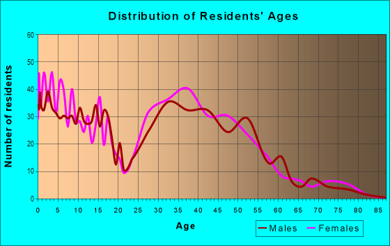
| Males: | 392 |
| Females: | 398 |
Males:
| This neighborhood: | 42.8 years |
| Whole city: | 33.4 years |
| This neighborhood: | 47.6 years |
| Whole city: | 35.2 years |
Average household size:
| Enclave at Spanos Park East: | 2.6 people |
| Stockton: | 3.2 people |
Percentage of family households:
| Enclave at Spanos Park East: | 54.9% |
| Stockton: | 51.0% |
| Here: | 69.2% |
| Stockton: | 42.0% |
Percentage of married-couple families with children (among all households):
| Enclave at Spanos Park East: | 27.2% |
| Stockton: | 19.2% |
Percentage of single-mother households (among all households):
| Enclave at Spanos Park East: | 13.9% |
| Stockton: | 9.1% |
Percentage of never married males 15 years old and over:
Percentage of never married females 15 years old and over:
| Enclave at Spanos Park East: | 16.3% |
| Stockton: | 21.6% |
Percentage of never married females 15 years old and over:
| Enclave at Spanos Park East: | 15.9% |
| city: | 19.3% |
Percentage of people that speak English not well or not at all:
| Enclave at Spanos Park East: | 0.0% |
| Stockton: | 12.0% |
Percentage of people born in this state:
Percentage of people born in another U.S. state:
Percentage of native residents but born outside the U.S.:
Percentage of foreign born residents:
| Here: | 70.0% |
| Stockton: | 66.1% |
Percentage of people born in another U.S. state:
| Enclave at Spanos Park East: | 10.4% |
| Stockton: | 7.2% |
Percentage of native residents but born outside the U.S.:
| Here: | 1.1% |
| city: | 1.5% |
Percentage of foreign born residents:
| Here: | 18.5% |
| Stockton: | 25.2% |
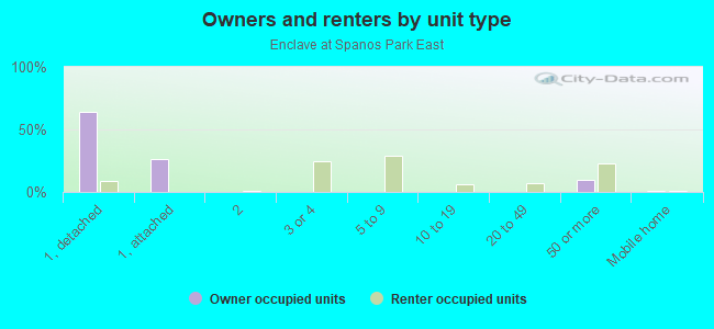
Owner-occupied
Renter-occupied

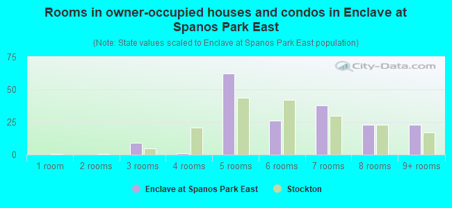
- Rooms in owner-occupied houses and condos in Enclave at Spanos Park East
- 01 room
- 02 rooms
- 93 rooms
- 14 rooms
- 625 rooms
- 266 rooms
- 387 rooms
- 238 rooms
- 239+ rooms
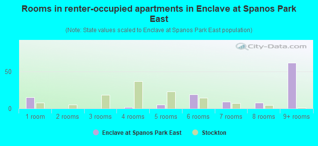
- Rooms in renter-occupied apartments in Enclave at Spanos Park East
- 151 room
- 02 rooms
- 03 rooms
- 24 rooms
- 55 rooms
- 196 rooms
- 97 rooms
- 88 rooms
- 629+ rooms
Owner-occupied
Renter-occupied
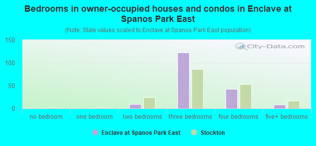
- Bedrooms in owner-occupied houses and condos in Enclave at Spanos Park East
- 0no bedroom
- 01 bedroom
- 102 bedrooms
- 1223 bedrooms
- 434 bedrooms
- 95+ bedrooms
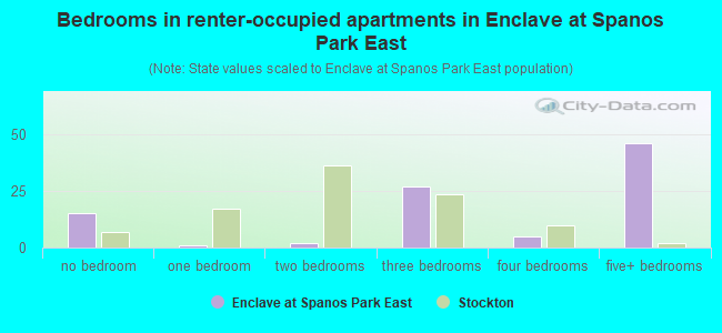
- Bedrooms in renter-occupied apartments in Enclave at Spanos Park East
- 15no bedroom
- 11 bedroom
- 22 bedrooms
- 273 bedrooms
- 54 bedrooms
- 465+ bedrooms
Average number of cars or other vehicles available in houses/condos:
Average number of cars or other vehicles available in apartments:
| This neighborhood: | 2.3 |
| Stockton: | 2.3 |
Average number of cars or other vehicles available in apartments:
| Here: | 2.0 |
| city: | 1.6 |
Percentage of units with a mortgage:
| Enclave at Spanos Park East: | 61.1% |
| Stockton: | 70.5% |
Housing prices:
- Average estimated value of detached houses in 2022 (95.0% of all units):
Enclave at Spanos Park East: $392,174 California: $988,808
- Average estimated value of townhouses or other attached units in 2022 (29.6% of all units):
This neighborhood: $402,045 California: $838,546
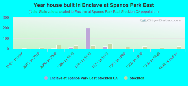
- Year house built in Enclave at Spanos Park East
- 02020 or later
- 02010 to 2019
- 22000 to 2009
- 131990 to 1999
- 1991980 to 1989
- 231970 to 1979
- 11960 to 1969
- 01950 to 1959
- 01940 to 1949
- 01939 or earlier
City-data.com crime index for city in 2020 (higher means more crime):
| City: | 505.2 |
| U.S. average: | 219.5 |
Travel time to work (commute)
![Travel time to work (commute)]()
- 1Less than 5 minutes
- 65 to 9 minutes
- 6510 to 14 minutes
- 5715 to 19 minutes
- 5920 to 24 minutes
- 2325 to 29 minutes
- 1630 to 34 minutes
- 135 to 39 minutes
- 140 to 44 minutes
- 1545 to 59 minutes
- 1460 to 89 minutes
- 1490 or more minutes

Means of transportation to work
![Means of transportation to work]()
- 71.6%222Drove a car alone
- 11.3%35Carpooled
- 40.3%125Bus
- 16.5%51Motorcycle
- 1.3%4Other means
- 14.2%44Worked at home

Time leaving home to go to work
![Time leaving home to go to work]()
- 2012:00 a.m. to 4:59 a.m.
- 105:00 a.m. to 5:29 a.m.
- 125:30 a.m. to 5:59 a.m.
- 196:00 a.m. to 6:29 a.m.
- 346:30 a.m. to 6:59 a.m.
- 437:00 a.m. to 7:29 a.m.
- 357:30 a.m. to 7:59 a.m.
- 318:00 a.m. to 8:29 a.m.
- 88:30 a.m. to 8:59 a.m.
- 39:00 a.m. to 9:59 a.m.
- 1410:00 a.m. to 10:59 a.m.
- 3011:00 a.m. to 11:59 a.m.
- 1812:00 p.m. to 3:59 p.m.
- 294:00 p.m. to 11:59 p.m.

Occupations of males:
- Percentage of males in management occupations (except farmers):
Here: 2.4% city: 6.6%
- Percentage of males in business and financial operations occupations:
Here: 2.5% city: 2.1%
- Percentage of males in architecture and engineering occupations:
Here: 3.0% city: 1.6%
- Percentage of males in life, physical, and social science occupations:
Here: 4.4% city: 0.4%
- Percentage of males in healthcare practitioners and technical occupations:
Here: 5.0% city: 2.7%
- Percentage of males in service occupations:
Here: 8.7% city: 16.9%
- Percentage of males in sales and office occupations:
Here: 2.9% city: 13.8%
- Percentage of males in farming, fishing, and forestry occupations:
Here: 2.4% city: 4.6%
- Percentage of males in construction, extraction, and maintenance occupations:
Here: 5.7% city: 10.5%
- Percentage of males in production occupations:
Here: 15.0% city: 8.0%
- Percentage of males in transportation occupations:
Here: 16.9% city: 9.6%
- Percentage of males in material moving occupations:
Here: 13.0% city: 10.7%
Occupations of females:
- Percentage of females in management occupations (except farmers):
Here: 8.4% city: 5.9%
- Percentage of females in business and financial operations occupations:
Here: 11.9% city: 5.2%
- Percentage of females in architecture and engineering occupations:
Here: 1.2% city: 0.3%
- Percentage of females in life, physical, and social science occupations:
Here: 1.8% city: 0.8%
- Percentage of females in community and social services occupations:
Here: 5.0% city: 2.9%
- Percentage of females in legal occupations:
Here: 1.7% city: 0.6%
- Percentage of females in education, training, and library occupations:
Here: 8.5% city: 7.8%
- Percentage of females in arts, design, entertainment, sports, and media occupations:
Here: 1.2% city: 0.9%
- Percentage of females in healthcare practitioners and technical occupations:
Here: 3.9% city: 8.3%
- Percentage of females in service occupations:
Here: 30.8% city: 24.4%
- Percentage of females in sales and office occupations:
Here: 22.4% city: 26.5%
- Percentage of females in production occupations:
Here: 8.2% city: 4.6%
Percentage of people 16-64 in Armed Forces:
| Enclave at Spanos Park East: | 0.0% |
| Stockton: | 0.1% |
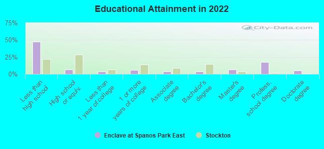
Education in this neighborhood (subdivision or community):
- Percentage of people 3 years and older in K-12 schools:
Enclave at Spanos Park East: 46.5% Stockton: 20.8%
- Percentage of people 3 years and older in undergraduate colleges:
Enclave at Spanos Park East: 63.7% Stockton: 5.2%
- Percentage of people 3 years and older in grad. or professional schools:
Enclave at Spanos Park East: 1.0% Stockton: 1.3%
- Percentage of students K-12 enrolled in private schools:
Enclave at Spanos Park East: 44.8% Stockton: 4.2%
Percentage of population below poverty level:
| Enclave at Spanos Park East: | 11.8% |
| Stockton: | 14.8% |
Median year owner moved in (as recorded in 2022):
Median year renter moved in (as recorded in 2022):
| Enclave at Spanos Park East: | 2006 |
| Stockton: | 2011 |
Median year renter moved in (as recorded in 2022):
| Enclave at Spanos Park East: | 2016 |
| Stockton: | 2018 |
Percentage of married-couple families with both working:
| Enclave at Spanos Park East: | 492.4% |
| Stockton: | 67.8% |
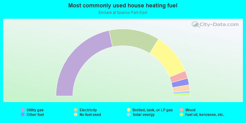
- 43.3%Utility gas
- 24.5%Electricity
- 20.0%Bottled, tank, or LP gas
- 3.7%Wood
- 3.2%Other fuel
- 2.8%No fuel used
- 1.4%Solar energy
- 1.1%Fuel oil, kerosene, etc.
Limited-access highways (interstate or state) in this neighborhood:
I- 5
Length: 2.16 miles
Directions: N-S, SE-NW
Directions: N-S, SE-NW
Roads and streets:
W Eight Mile Rd
Length: 2.80 miles
Direction: E-W
Address range: 2230 to 5198
Direction: E-W
Address range: 2230 to 5198
Whistler Way
Length: 1.79 miles
Directions: E-W, N-S, SW-NE
Address range: 1900 to 2399
Directions: E-W, N-S, SW-NE
Address range: 1900 to 2399
A G Spanos Blvd
Length: 1.78 miles
Directions: E-W, N-S, SE-NW, SW-NE
Address range: 3700 to 4599
Directions: E-W, N-S, SE-NW, SW-NE
Address range: 3700 to 4599
Iron Canyon Cir
Length: 1.49 miles
Directions: E-W, N-S, SE-NW, SW-NE
Address range: 3400 to 3899
Directions: E-W, N-S, SE-NW, SW-NE
Address range: 3400 to 3899
Miwok Trl
Length: 1.42 miles
Directions: E-W, N-S, SE-NW, SW-NE
Directions: E-W, N-S, SE-NW, SW-NE
Thornton Rd (N Thornton Rd)
Length: 1.12 miles
Directions: N-S, SE-NW, SW-NE
Address range: 10100 to 10899
Directions: N-S, SE-NW, SW-NE
Address range: 10100 to 10899
Bear Creek Levee Rd
Length: 1.11 miles
Direction: E-W
Direction: E-W
Lonnie Beck Way
Length: 1.04 miles
Directions: E-W, SW-NE
Address range: 1900 to 2999
Directions: E-W, SW-NE
Address range: 1900 to 2999
Davis Rd
Length: 1.04 miles
Directions: N-S, SE-NW, SW-NE
Address range: 9910 to 10899
Directions: N-S, SE-NW, SW-NE
Address range: 9910 to 10899
Joshua Tree Cir
Length: 0.82 miles
Directions: E-W, N-S, SE-NW
Address range: 3000 to 3299
Directions: E-W, N-S, SE-NW
Address range: 3000 to 3299
Hepburn Cir
Length: 0.73 miles
Directions: E-W, N-S, SE-NW, SW-NE
Address range: 3405 to 3799
Directions: E-W, N-S, SE-NW, SW-NE
Address range: 3405 to 3799
Black Butte Cir
Length: 0.73 miles
Directions: E-W, N-S, SE-NW, SW-NE
Address range: 3800 to 4299
Directions: E-W, N-S, SE-NW, SW-NE
Address range: 3800 to 4299
Maddie Cir
Length: 0.72 miles
Directions: E-W, N-S, SW-NE
Address range: 4000 to 4399
Directions: E-W, N-S, SW-NE
Address range: 4000 to 4399
Waterbury Dr
Length: 0.67 miles
Directions: E-W, N-S, SW-NE
Address range: 10500 to 10899
Directions: E-W, N-S, SW-NE
Address range: 10500 to 10899
Fire Island Cir
Length: 0.66 miles
Directions: E-W, N-S, SE-NW, SW-NE
Address range: 10700 to 10999
Directions: E-W, N-S, SE-NW, SW-NE
Address range: 10700 to 10999
River View Cir
Length: 0.64 miles
Directions: E-W, N-S
Address range: 9900 to 10099
Directions: E-W, N-S
Address range: 9900 to 10099
River Falls Cir
Length: 0.57 miles
Directions: E-W, N-S, SE-NW, SW-NE
Address range: 10080 to 10183
Directions: E-W, N-S, SE-NW, SW-NE
Address range: 10080 to 10183
River Oaks Dr
Length: 0.55 miles
Directions: E-W, N-S, SE-NW
Address range: 9900 to 10498
Directions: E-W, N-S, SE-NW
Address range: 9900 to 10498
Creek Trail Cir
Length: 0.54 miles
Directions: E-W, N-S
Address range: 10000 to 10399
Directions: E-W, N-S
Address range: 10000 to 10399
Point Reyes Cir
Length: 0.53 miles
Directions: E-W, N-S, SW-NE
Address range: 10200 to 10498
Directions: E-W, N-S, SW-NE
Address range: 10200 to 10498
Breaker Way
Length: 0.50 miles
Directions: E-W, SE-NW
Directions: E-W, SE-NW
Des Moines Dr
Length: 0.48 miles
Directions: E-W, SW-NE
Address range: 3400 to 4099
Directions: E-W, SW-NE
Address range: 3400 to 4099
River Park Cir
Length: 0.47 miles
Directions: E-W, N-S, SE-NW, SW-NE
Address range: 10084 to 10299
Directions: E-W, N-S, SE-NW, SW-NE
Address range: 10084 to 10299
Big Oak Cir
Length: 0.47 miles
Directions: E-W, N-S
Address range: 10300 to 10599
Directions: E-W, N-S
Address range: 10300 to 10599
Nations Cir
Length: 0.46 miles
Directions: E-W, N-S
Address range: 10200 to 10499
Directions: E-W, N-S
Address range: 10200 to 10499
Eagle Rock Cir
Length: 0.46 miles
Directions: E-W, N-S, SW-NE
Address range: 2500 to 2799
Directions: E-W, N-S, SW-NE
Address range: 2500 to 2799
Grandi Cir
Length: 0.45 miles
Directions: E-W, N-S, SE-NW, SW-NE
Address range: 3400 to 3599
Directions: E-W, N-S, SE-NW, SW-NE
Address range: 3400 to 3599
Swainsons Hawk St
Length: 0.43 miles
Direction: E-W
Address range: 2100 to 2299
Direction: E-W
Address range: 2100 to 2299
Orvis Dr
Length: 0.43 miles
Direction: E-W
Address range: 1700 to 2199
Direction: E-W
Address range: 1700 to 2199
Lebaron Dr
Length: 0.41 miles
Direction: E-W
Address range: 1700 to 2200
Direction: E-W
Address range: 1700 to 2200
Pleasant Valley Cir
Length: 0.41 miles
Directions: E-W, N-S, SE-NW, SW-NE
Address range: 10600 to 10899
Directions: E-W, N-S, SE-NW, SW-NE
Address range: 10600 to 10899
Rivermont Dr
Length: 0.41 miles
Directions: E-W, N-S, SE-NW
Directions: E-W, N-S, SE-NW
Vancouver Cir
Length: 0.41 miles
Directions: E-W, N-S, SE-NW, SW-NE
Address range: 3800 to 3999
Directions: E-W, N-S, SE-NW, SW-NE
Address range: 3800 to 3999
Hidden Grove Cir
Length: 0.41 miles
Directions: E-W, N-S
Address range: 10500 to 10799
Directions: E-W, N-S
Address range: 10500 to 10799
Autumn Oak Pl
Length: 0.40 miles
Direction: SW-NE
Address range: 1900 to 2499
Direction: SW-NE
Address range: 1900 to 2499
Winward Ave
Length: 0.39 miles
Directions: N-S, SE-NW
Address range: 10500 to 10799
Directions: N-S, SE-NW
Address range: 10500 to 10799
Praire Ln
Length: 0.37 miles
Direction: E-W
Address range: 1900 to 1999
Direction: E-W
Address range: 1900 to 1999
Oak Tree Ln
Length: 0.37 miles
Direction: E-W
Address range: 1900 to 1999
Direction: E-W
Address range: 1900 to 1999
Cornerstone Cir
Length: 0.35 miles
Directions: E-W, N-S, SE-NW, SW-NE
Address range: 10500 to 10699
Directions: E-W, N-S, SE-NW, SW-NE
Address range: 10500 to 10699
Stony Gorge Dr
Length: 0.32 miles
Directions: N-S, SE-NW, SW-NE
Directions: N-S, SE-NW, SW-NE
Big Sur St
Length: 0.31 miles
Directions: E-W, SE-NW
Address range: 2600 to 2999
Directions: E-W, SE-NW
Address range: 2600 to 2999
Sellers Cir
Length: 0.31 miles
Directions: E-W, N-S
Directions: E-W, N-S
Chatfield Cir
Length: 0.30 miles
Directions: E-W, N-S, SW-NE
Address range: 1700 to 1899
Directions: E-W, N-S, SW-NE
Address range: 1700 to 1899
Willow Glen Cir
Length: 0.29 miles
Directions: E-W, SW-NE
Address range: 10600 to 10799
Directions: E-W, SW-NE
Address range: 10600 to 10799
Gerber Dr
Length: 0.28 miles
Direction: E-W
Address range: 1900 to 2199
Direction: E-W
Address range: 1900 to 2199
New Brighton Ln
Length: 0.27 miles
Direction: E-W
Direction: E-W
Macon Dr
Length: 0.26 miles
Direction: N-S
Address range: 10000 to 10499
Direction: N-S
Address range: 10000 to 10499
Flaming Star Ln
Length: 0.24 miles
Directions: N-S, SE-NW
Directions: N-S, SE-NW
Savoy Cir
Length: 0.23 miles
Directions: E-W, N-S
Directions: E-W, N-S
Bright Star Pl
Length: 0.23 miles
Directions: E-W, SW-NE
Address range: 2000 to 2199
Directions: E-W, SW-NE
Address range: 2000 to 2199
Golden Eagle Dr
Length: 0.22 miles
Direction: E-W
Direction: E-W
Bennington Ct
Length: 0.22 miles
Directions: E-W, SE-NW, SW-NE
Address range: 1500 to 1699
Directions: E-W, SE-NW, SW-NE
Address range: 1500 to 1699
Wind Cave Cir
Length: 0.22 miles
Directions: E-W, N-S, SW-NE
Address range: 3700 to 3817
Directions: E-W, N-S, SW-NE
Address range: 3700 to 3817
River Bluff Ln
Length: 0.21 miles
Direction: N-S
Address range: 10000 to 10499
Direction: N-S
Address range: 10000 to 10499
Golden Eagle
Length: 0.21 miles
Direction: E-W
Direction: E-W
Rohde Dr
Length: 0.21 miles
Direction: E-W
Address range: 1500 to 1799
Direction: E-W
Address range: 1500 to 1799
Wellington Cir
Length: 0.21 miles
Directions: E-W, SE-NW, SW-NE
Address range: 10641 to 10711
Directions: E-W, SE-NW, SW-NE
Address range: 10641 to 10711
Waterfront Cir
Length: 0.21 miles
Directions: E-W, N-S, SE-NW
Address range: 3400 to 3499
Directions: E-W, N-S, SE-NW
Address range: 3400 to 3499
Evening St
Length: 0.21 miles
Direction: E-W
Direction: E-W
Amarillo Way
Length: 0.20 miles
Direction: E-W
Direction: E-W
Lands End Dr
Length: 0.20 miles
Direction: N-S
Direction: N-S
Sagebrush Way
Length: 0.20 miles
Direction: E-W
Direction: E-W
Beck Cir
Length: 0.19 miles
Directions: E-W, N-S
Directions: E-W, N-S
McAuliffe Rd
Length: 0.19 miles
Directions: E-W, SW-NE
Directions: E-W, SW-NE
Wave Crest Ln (Wavecrest Ln)
Length: 0.19 miles
Direction: E-W
Direction: E-W
Sweet Lilac
Length: 0.19 miles
Direction: E-W
Direction: E-W
Olivia Way
Length: 0.19 miles
Direction: E-W
Address range: 2000 to 2199
Direction: E-W
Address range: 2000 to 2199
Golden Poppy Ln
Length: 0.18 miles
Direction: E-W
Direction: E-W
Siskiyou Ln
Length: 0.17 miles
Directions: N-S, SE-NW
Address range: 10700 to 10799
Directions: N-S, SE-NW
Address range: 10700 to 10799
Little Grass Way
Length: 0.17 miles
Direction: E-W
Direction: E-W
Iris Bloom Dr
Length: 0.17 miles
Direction: N-S
Direction: N-S
Dutch Tulip Dr
Length: 0.16 miles
Direction: N-S
Direction: N-S
Hollow Tree Ln
Length: 0.16 miles
Direction: N-S
Address range: 10500 to 10799
Direction: N-S
Address range: 10500 to 10799
Chadsworth St
Length: 0.16 miles
Direction: E-W
Address range: 1700 to 1799
Direction: E-W
Address range: 1700 to 1799
Liotard Dr
Length: 0.16 miles
Direction: N-S
Address range: 9900 to 10099
Direction: N-S
Address range: 9900 to 10099
Beachcomber Dr
Length: 0.15 miles
Direction: N-S
Direction: N-S
McNabb St
Length: 0.15 miles
Direction: E-W
Address range: 3000 to 3099
Direction: E-W
Address range: 3000 to 3099
Honeysuckle
Length: 0.14 miles
Direction: N-S
Direction: N-S
Daisy Trl
Length: 0.14 miles
Direction: E-W
Direction: E-W
Sand Castle Way
Length: 0.14 miles
Direction: N-S
Direction: N-S
Lava Bed Ln
Length: 0.14 miles
Directions: N-S, SW-NE
Address range: 10800 to 10999
Directions: N-S, SW-NE
Address range: 10800 to 10999
Spring Creek Pl
Length: 0.14 miles
Directions: E-W, SE-NW
Address range: 10500 to 10699
Directions: E-W, SE-NW
Address range: 10500 to 10699
Freshwater Pt
Length: 0.13 miles
Directions: E-W, N-S, SE-NW
Address range: 10300 to 10499
Directions: E-W, N-S, SE-NW
Address range: 10300 to 10499
Oceanmist Way
Length: 0.13 miles
Direction: N-S
Direction: N-S
Peony Place Dr
Length: 0.13 miles
Direction: N-S
Direction: N-S
Campora Way
Length: 0.13 miles
Direction: N-S
Address range: 9900 to 10099
Direction: N-S
Address range: 9900 to 10099
Muir Woods Ave
Length: 0.13 miles
Directions: N-S, SW-NE
Address range: 10400 to 10499
Directions: N-S, SW-NE
Address range: 10400 to 10499
Tupelo Dr
Length: 0.13 miles
Directions: E-W, SW-NE
Address range: 3400 to 3499
Directions: E-W, SW-NE
Address range: 3400 to 3499
Canyonlands Rd
Length: 0.12 miles
Directions: SE-NW, SW-NE
Address range: 3800 to 3899
Directions: SE-NW, SW-NE
Address range: 3800 to 3899
Burkehollow Ln (Tramore Ln)
Length: 0.12 miles
Directions: N-S, SE-NW
Directions: N-S, SE-NW
Breiens Way
Length: 0.12 miles
Direction: E-W
Address range: 2100 to 2199
Direction: E-W
Address range: 2100 to 2199
Dover Dr
Length: 0.11 miles
Directions: N-S, SE-NW
Directions: N-S, SE-NW
Grey Hawk Ct
Length: 0.11 miles
Direction: N-S
Direction: N-S
Jennifer Ln
Length: 0.11 miles
Direction: N-S
Direction: N-S
Kaycee Ln
Length: 0.11 miles
Direction: N-S
Direction: N-S
Ocean Mist Way
Length: 0.11 miles
Direction: N-S
Direction: N-S
Sandberg Ln
Length: 0.10 miles
Direction: N-S
Address range: 10500 to 10699
Direction: N-S
Address range: 10500 to 10699
Brookfield Ave
Length: 0.10 miles
Direction: N-S
Address range: 10800 to 10899
Direction: N-S
Address range: 10800 to 10899
Galveston Way
Length: 0.10 miles
Direction: N-S
Direction: N-S
Sea Bird Way
Length: 0.10 miles
Direction: E-W
Direction: E-W
Morning Star
Length: 0.10 miles
Direction: N-S
Direction: N-S
Kayla
Length: 0.10 miles
Direction: N-S
Direction: N-S
Raptor Dr
Length: 0.10 miles
Direction: E-W
Address range: 4200 to 4299
Direction: E-W
Address range: 4200 to 4299
Samantha Dr
Length: 0.10 miles
Direction: N-S
Address range: 10600 to 10799
Direction: N-S
Address range: 10600 to 10799
Sea Horse
Length: 0.10 miles
Direction: E-W
Direction: E-W
Donner Ave
Length: 0.09 miles
Direction: N-S
Address range: 10400 to 10499
Direction: N-S
Address range: 10400 to 10499
Trevor Dr
Length: 0.09 miles
Direction: N-S
Address range: 10600 to 10799
Direction: N-S
Address range: 10600 to 10799
Pelican Dr
Length: 0.09 miles
Direction: N-S
Direction: N-S
Sea Bright
Length: 0.09 miles
Direction: N-S
Direction: N-S
Honeybrook St
Length: 0.09 miles
Direction: E-W
Address range: 2100 to 2199
Direction: E-W
Address range: 2100 to 2199
Greenbrook St
Length: 0.09 miles
Directions: E-W, SE-NW
Address range: 10400 to 10599
Directions: E-W, SE-NW
Address range: 10400 to 10599
Blackhawk Ct
Length: 0.09 miles
Direction: N-S
Address range: 10500 to 10699
Direction: N-S
Address range: 10500 to 10699
Brandon St
Length: 0.09 miles
Direction: SW-NE
Direction: SW-NE
Thompson Way
Length: 0.09 miles
Direction: N-S
Address range: 9900 to 10099
Direction: N-S
Address range: 9900 to 10099
Wendt Way
Length: 0.09 miles
Direction: N-S
Address range: 9900 to 10099
Direction: N-S
Address range: 9900 to 10099
Calla Lily
Length: 0.09 miles
Direction: E-W
Direction: E-W
Humboldt Pl
Length: 0.08 miles
Direction: N-S
Address range: 10300 to 10499
Direction: N-S
Address range: 10300 to 10499
Rihn Way
Length: 0.08 miles
Direction: N-S
Address range: 9900 to 9999
Direction: N-S
Address range: 9900 to 9999
Banyon Dr
Length: 0.08 miles
Direction: E-W
Address range: 3400 to 3499
Direction: E-W
Address range: 3400 to 3499
Gable Ct
Length: 0.08 miles
Direction: E-W
Address range: 3300 to 3399
Direction: E-W
Address range: 3300 to 3399
Silent Grove Ct
Length: 0.08 miles
Direction: N-S
Address range: 10500 to 10599
Direction: N-S
Address range: 10500 to 10599
Tioga Dr
Length: 0.08 miles
Direction: E-W
Address range: 3400 to 3499
Direction: E-W
Address range: 3400 to 3499
Putnam Way
Length: 0.08 miles
Direction: N-S
Address range: 9900 to 9999
Direction: N-S
Address range: 9900 to 9999
Saddlebrook St
Length: 0.07 miles
Direction: E-W
Direction: E-W
Cliffside
Length: 0.07 miles
Direction: N-S
Direction: N-S
el Paso Way
Length: 0.07 miles
Direction: N-S
Direction: N-S
Longhorn Way
Length: 0.07 miles
Direction: N-S
Direction: N-S
Pleasant Valley Ct
Length: 0.07 miles
Directions: E-W, N-S
Address range: 10900 to 10999
Directions: E-W, N-S
Address range: 10900 to 10999
Big Sky Way
Length: 0.07 miles
Direction: N-S
Address range: 10400 to 10499
Direction: N-S
Address range: 10400 to 10499
Lone Star Way
Length: 0.07 miles
Direction: N-S
Address range: 10400 to 10499
Direction: N-S
Address range: 10400 to 10499
Oak Shores Dr
Length: 0.07 miles
Direction: E-W
Address range: 3500 to 3531
Direction: E-W
Address range: 3500 to 3531
Wild Berry
Length: 0.06 miles
Direction: N-S
Direction: N-S
Siemering Way
Length: 0.06 miles
Direction: E-W
Address range: 1500 to 1599
Direction: E-W
Address range: 1500 to 1599
Garbo Ct
Length: 0.06 miles
Directions: N-S, SE-NW
Address range: 10200 to 10299
Directions: N-S, SE-NW
Address range: 10200 to 10299
Lafever
Length: 0.06 miles
Direction: N-S
Direction: N-S
Carnegie Ct
Length: 0.06 miles
Direction: N-S
Address range: 10400 to 10499
Direction: N-S
Address range: 10400 to 10499
Tahoe Way
Length: 0.06 miles
Direction: N-S
Address range: 10000 to 10099
Direction: N-S
Address range: 10000 to 10099
Tony Ct
Length: 0.06 miles
Direction: N-S
Direction: N-S
Mystic Ct
Length: 0.06 miles
Direction: E-W
Address range: 2400 to 2499
Direction: E-W
Address range: 2400 to 2499
Lava Bed Ct
Length: 0.05 miles
Directions: E-W, SE-NW
Address range: 3400 to 3499
Directions: E-W, SE-NW
Address range: 3400 to 3499
Sitka Ct
Length: 0.05 miles
Direction: E-W
Address range: 3400 to 3499
Direction: E-W
Address range: 3400 to 3499
Kane Way
Length: 0.05 miles
Direction: N-S
Address range: 10000 to 10099
Direction: N-S
Address range: 10000 to 10099
Ivy Rose
Length: 0.05 miles
Directions: E-W, N-S, SE-NW
Directions: E-W, N-S, SE-NW
Oceanmist Ct
Length: 0.05 miles
Direction: E-W
Direction: E-W
Chatfield Ct
Length: 0.05 miles
Direction: SW-NE
Address range: 10600 to 10699
Direction: SW-NE
Address range: 10600 to 10699
Tulloch Ct
Length: 0.05 miles
Direction: SE-NW
Address range: 10400 to 10499
Direction: SE-NW
Address range: 10400 to 10499
Cornerstone Ct
Length: 0.04 miles
Direction: SW-NE
Address range: 1900 to 1999
Direction: SW-NE
Address range: 1900 to 1999
Grace Louise Pl
Length: 0.04 miles
Direction: E-W
Address range: 2800 to 2899
Direction: E-W
Address range: 2800 to 2899
Kings Canyon Ct
Length: 0.03 miles
Directions: E-W, N-S
Address range: 10000 to 10099
Directions: E-W, N-S
Address range: 10000 to 10099
Crescent Pt
Length: 0.03 miles
Direction: N-S
Address range: 10400 to 10499
Direction: N-S
Address range: 10400 to 10499
Lombard Ct
Length: 0.03 miles
Direction: N-S
Address range: 1025 to 10399
Direction: N-S
Address range: 1025 to 10399
Sand Castle Ct
Length: 0.03 miles
Direction: E-W
Direction: E-W
Zion Ln
Length: 0.03 miles
Direction: N-S
Direction: N-S
Teton Ct
Length: 0.03 miles
Direction: N-S
Address range: 10400 to 10499
Direction: N-S
Address range: 10400 to 10499
Saddleback Ct
Length: 0.03 miles
Direction: N-S
Direction: N-S
Oli (Lafever Way)
Length: 0.03 miles
Directions: E-W, N-S
Directions: E-W, N-S
Sandy Gulch
Length: 0.03 miles
Direction: N-S
Direction: N-S
Aspenwood Ln
Length: 0.03 miles
Direction: N-S
Address range: 10500 to 10599
Direction: N-S
Address range: 10500 to 10599
Wave Crest Ct (Wavecrest Ct)
Length: 0.03 miles
Direction: N-S
Direction: N-S
Brando Ct
Length: 0.03 miles
Direction: SE-NW
Address range: 10200 to 10299
Direction: SE-NW
Address range: 10200 to 10299
Dylan Ct
Length: 0.03 miles
Direction: N-S
Address range: 10600 to 10645
Direction: N-S
Address range: 10600 to 10645
Sea Cliff
Length: 0.03 miles
Direction: N-S
Direction: N-S
Sea Hawk
Length: 0.03 miles
Direction: N-S
Direction: N-S
Lena Ct
Length: 0.02 miles
Direction: N-S
Address range: 10001 to 10033
Direction: N-S
Address range: 10001 to 10033
Coldcreek Dr
Length: 0.02 miles
Direction: N-S
Address range: 10700 to 10799
Direction: N-S
Address range: 10700 to 10799
Arcata Ct
Length: 0.02 miles
Direction: N-S
Address range: 10400 to 10499
Direction: N-S
Address range: 10400 to 10499
Nations Ct
Length: 0.02 miles
Direction: N-S
Address range: 10100 to 10199
Direction: N-S
Address range: 10100 to 10199
Dusty Ct
Length: 0.02 miles
Direction: N-S
Direction: N-S
Dusty
Length: 0.02 miles
Directions: N-S, SW-NE
Directions: N-S, SW-NE
Wellington Ct
Length: 0.02 miles
Direction: SW-NE
Address range: 1900 to 1928
Direction: SW-NE
Address range: 1900 to 1928
Chaplin Ct
Length: 0.02 miles
Direction: SE-NW
Address range: 10200 to 10299
Direction: SE-NW
Address range: 10200 to 10299
Mansfield Ct
Length: 0.02 miles
Direction: E-W
Address range: 3300 to 3399
Direction: E-W
Address range: 3300 to 3399
Falcon Ct
Length: 0.02 miles
Direction: SW-NE
Address range: 10300 to 10399
Direction: SW-NE
Address range: 10300 to 10399
Other features:
Bear Crk (Pixley Slough)
Length: 0.02 miles
Direction: E-W
Direction: E-W