Prairie Tree neighborhood in Sioux Falls, South Dakota (SD), 57105, 57108 detailed profile
Settings
X

Business Search - 14 Million verified businesses
Area: 4.232 square miles
Population: 5,834
Population density:
| Prairie Tree: | 1,378 people per square mile |
| Sioux Falls: | 3,588 people per square mile |

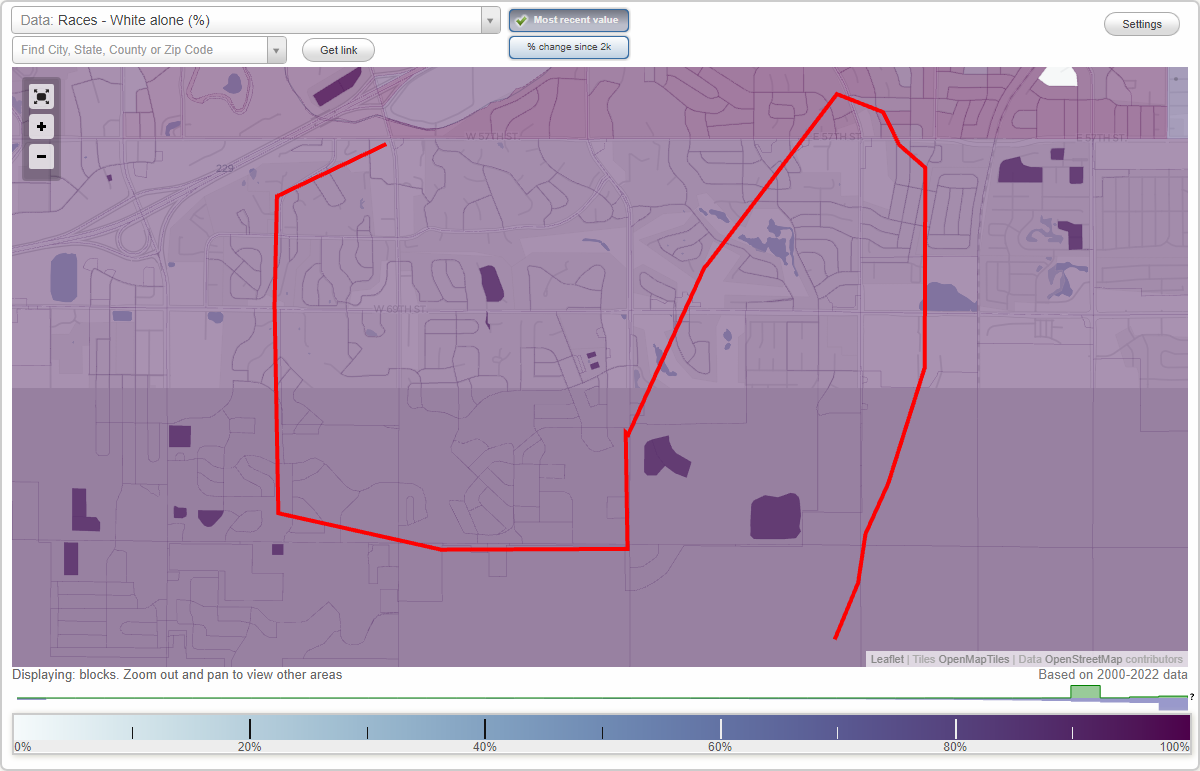
- 5,76697.5%White
- 671.1%Hispanic or Latino
- 490.8%Two or more races
- 300.5%Asian

Median household income in 2022:
| Prairie Tree: | $143,984 |
| Sioux Falls: | $71,246 |
Distribution of median household income
![Distribution of median household income]()
- 36Less than $10,000
- 215$10,000 to $19,999
- 78$20,000 to $29,999
- 103$30,000 to $39,999
- 106$40,000 to $49,999
- 94$50,000 to $59,999
- 151$60,000 to $74,999
- 161$75,000 to $99,999
- 122$100,000 to $124,999
- 286$125,000 to $149,999
- 318$150,000 to $199,999
- 796$200,000 or more

Distribution of owner-occupied house/condo value
![Distribution of owner-occupied house/condo value]()
- 49Less than $50,000
- 49$50,000 to $99,999
- 87$100,000 to $149,999
- 61$150,000 to $199,999
- 199$200,000 to $249,999
- 299$250,000 to $299,999
- 510$300,000 to $399,999
- 193$400,000 to $499,999
- 187$500,000 to $749,999
- 45$750,000 to $999,999
- 321$1,000,000 or more

Distribution of rent paid by renters
![Distribution of rent paid by renters]()
- 100$700 to $799
- 212$800 to $899
- 187$900 to $999

Median rent in 2022:
| Prairie Tree: | $870 |
| Sioux Falls: | $866 |
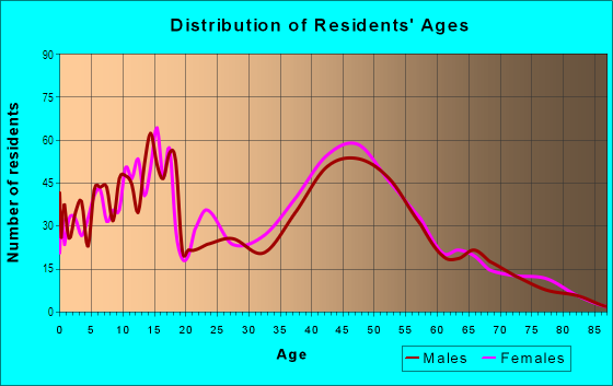
| Males: | 2,889 |
| Females: | 2,944 |
Males:
| This neighborhood: | 56.4 years |
| Whole city: | 35.1 years |
| This neighborhood: | 55.8 years |
| Whole city: | 38.0 years |
Average household size:
| Prairie Tree: | 2.4 people |
| Sioux Falls: | 2.3 people |
Percentage of family households:
| Prairie Tree: | 56.6% |
| Sioux Falls: | 42.9% |
| Here: | 61.9% |
| Sioux Falls: | 44.4% |
Percentage of married-couple families with children (among all households):
| Prairie Tree: | 28.4% |
| Sioux Falls: | 31.1% |
Percentage of single-mother households (among all households):
| Prairie Tree: | 13.4% |
| Sioux Falls: | 7.5% |
Percentage of never married males 15 years old and over:
Percentage of never married females 15 years old and over:
| Prairie Tree: | 10.1% |
| Sioux Falls: | 18.5% |
Percentage of never married females 15 years old and over:
| Prairie Tree: | 4.0% |
| city: | 13.9% |
Percentage of people that speak English not well or not at all:
| Prairie Tree: | 0.0% |
| Sioux Falls: | 1.6% |
Percentage of people born in this state:
Percentage of people born in another U.S. state:
Percentage of native residents but born outside the U.S.:
Percentage of foreign born residents:
| Here: | 58.6% |
| Sioux Falls: | 56.6% |
Percentage of people born in another U.S. state:
| Prairie Tree: | 41.2% |
| Sioux Falls: | 35.3% |
Percentage of native residents but born outside the U.S.:
| Here: | 0.0% |
| city: | 0.7% |
Percentage of foreign born residents:
| Here: | 0.2% |
| Sioux Falls: | 7.4% |
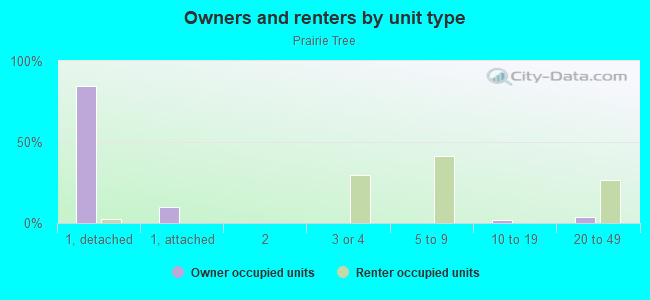
Owner-occupied
Renter-occupied

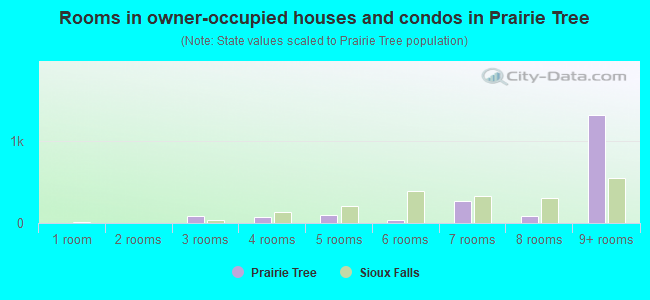
- Rooms in owner-occupied houses and condos in Prairie Tree
- 01 room
- 02 rooms
- 833 rooms
- 704 rooms
- 1025 rooms
- 356 rooms
- 2757 rooms
- 898 rooms
- 1,3249+ rooms
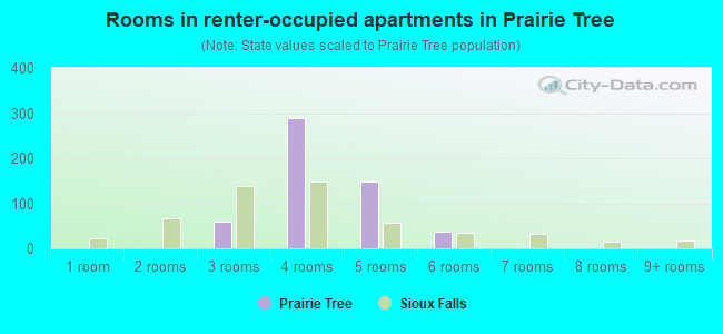
- Rooms in renter-occupied apartments in Prairie Tree
- 01 room
- 02 rooms
- 603 rooms
- 2884 rooms
- 1475 rooms
- 366 rooms
- 07 rooms
- 08 rooms
- 09+ rooms
Owner-occupied
Renter-occupied
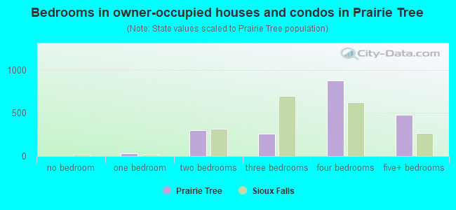
- Bedrooms in owner-occupied houses and condos in Prairie Tree
- 0no bedroom
- 351 bedroom
- 3012 bedrooms
- 2593 bedrooms
- 8754 bedrooms
- 4745+ bedrooms
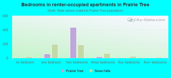
- Bedrooms in renter-occupied apartments in Prairie Tree
- 0no bedroom
- 601 bedroom
- 4362 bedrooms
- 183 bedrooms
- 04 bedrooms
- 05+ bedrooms
Average number of cars or other vehicles available in houses/condos:
Average number of cars or other vehicles available in apartments:
| This neighborhood: | 2.8 |
| Sioux Falls: | 2.1 |
Average number of cars or other vehicles available in apartments:
| Here: | 2.0 |
| city: | 1.3 |
Percentage of units with a mortgage:
| Prairie Tree: | 62.8% |
| Sioux Falls: | 67.3% |
Housing prices:
- Average estimated value of detached houses in 2022 (64.8% of all units):
Prairie Tree: $660,934 South Dakota: $303,134
- Average estimated value of townhouses or other attached units in 2022 (7.5% of all units):
This neighborhood: $284,966 South Dakota: $292,182
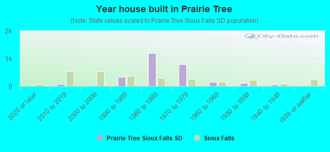
- Year house built in Prairie Tree
- 02020 or later
- 812010 to 2019
- 382000 to 2009
- 3331990 to 1999
- 1,1961980 to 1989
- 7921970 to 1979
- 1411960 to 1969
- 1121950 to 1959
- 601940 to 1949
- 01939 or earlier
City-data.com crime index for city in 2020 (higher means more crime):
| City: | 324.5 |
| U.S. average: | 219.5 |
Travel time to work (commute)
![Travel time to work (commute)]()
- 3515 to 9 minutes
- 1,26010 to 14 minutes
- 1,42615 to 19 minutes
- 41720 to 24 minutes
- 3225 to 29 minutes
- 24630 to 34 minutes
- 1940 to 44 minutes
- 3545 to 59 minutes

Means of transportation to work
![Means of transportation to work]()
- 77.3%2,966Drove a car alone
- 5.0%192Carpooled
- 17.7%679Worked at home

Time leaving home to go to work
![Time leaving home to go to work]()
- 4712:00 a.m. to 4:59 a.m.
- 1255:30 a.m. to 5:59 a.m.
- 1686:00 a.m. to 6:29 a.m.
- 4896:30 a.m. to 6:59 a.m.
- 7227:00 a.m. to 7:29 a.m.
- 8297:30 a.m. to 7:59 a.m.
- 5278:00 a.m. to 8:29 a.m.
- 1428:30 a.m. to 8:59 a.m.
- 3239:00 a.m. to 9:59 a.m.
- 7510:00 a.m. to 10:59 a.m.
- 23712:00 p.m. to 3:59 p.m.
- 814:00 p.m. to 11:59 p.m.

Occupations of males:
- Percentage of males in management occupations (except farmers):
Here: 30.1% city: 12.4%
- Percentage of males in business and financial operations occupations:
Here: 3.7% city: 4.8%
- Percentage of males in computer and mathematical occupations:
Here: 2.1% city: 4.9%
- Percentage of males in architecture and engineering occupations:
Here: 2.7% city: 2.5%
- Percentage of males in community and social services occupations:
Here: 5.1% city: 1.0%
- Percentage of males in legal occupations:
Here: 2.1% city: 0.7%
- Percentage of males in arts, design, entertainment, sports, and media occupations:
Here: 2.8% city: 1.6%
- Percentage of males in healthcare practitioners and technical occupations:
Here: 2.2% city: 3.9%
- Percentage of males in service occupations:
Here: 14.1% city: 12.3%
- Percentage of males in sales and office occupations:
Here: 19.1% city: 16.6%
- Percentage of males in construction, extraction, and maintenance occupations:
Here: 1.1% city: 7.8%
- Percentage of males in production occupations:
Here: 13.2% city: 9.0%
- Percentage of males in transportation occupations:
Here: 4.9% city: 6.2%
- Percentage of males in material moving occupations:
Here: 9.4% city: 6.3%
Occupations of females:
- Percentage of females in management occupations (except farmers):
Here: 5.8% city: 8.4%
- Percentage of females in business and financial operations occupations:
Here: 6.4% city: 6.2%
- Percentage of females in computer and mathematical occupations:
Here: 3.2% city: 2.1%
- Percentage of females in legal occupations:
Here: 2.6% city: 1.0%
- Percentage of females in education, training, and library occupations:
Here: 3.2% city: 7.4%
- Percentage of females in arts, design, entertainment, sports, and media occupations:
Here: 2.6% city: 1.8%
- Percentage of females in healthcare practitioners and technical occupations:
Here: 15.8% city: 14.9%
- Percentage of females in service occupations:
Here: 23.7% city: 20.9%
- Percentage of females in sales and office occupations:
Here: 30.7% city: 26.5%
- Percentage of females in production occupations:
Here: 3.2% city: 4.3%
- Percentage of females in transportation occupations:
Here: 2.6% city: 0.5%
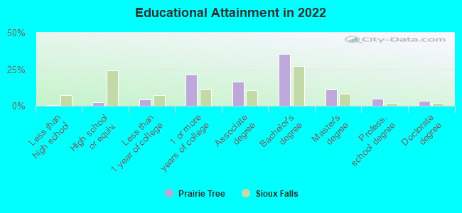
Education in this neighborhood (subdivision or community):
- Percentage of people 3 years and older in K-12 schools:
Prairie Tree: 11.4% Sioux Falls: 17.5%
- Percentage of people 3 years and older in undergraduate colleges:
Prairie Tree: 1.8% Sioux Falls: 4.1%
- Percentage of people 3 years and older in grad. or professional schools:
Prairie Tree: 1.5% Sioux Falls: 1.4%
- Percentage of students K-12 enrolled in private schools:
Prairie Tree: 20.3% Sioux Falls: 15.2%
Percentage of population below poverty level:
| Prairie Tree: | 3.3% |
| Sioux Falls: | 10.1% |
Median year owner moved in (as recorded in 2022):
| Prairie Tree: | 2011 |
| Sioux Falls: | 2014 |
Percentage of married-couple families with both working:
| Prairie Tree: | 135.5% |
| Sioux Falls: | 85.2% |
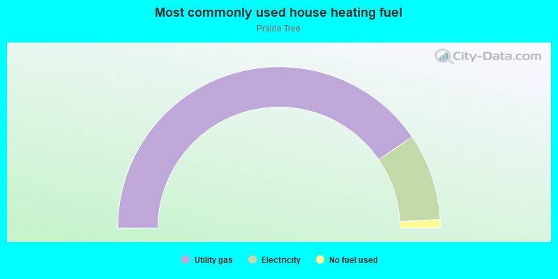
- 80.9%Utility gas
- 17.4%Electricity
- 1.7%No fuel used
Highways in this neighborhood:
State Hwy 115
Length: 1.99 miles
Directions: E-W, N-S, SE-NW, SW-NE
Address range: 5000 to 6499
Directions: E-W, N-S, SE-NW, SW-NE
Address range: 5000 to 6499
Roads and streets:
269th St (W 69th St)
Length: 2.53 miles
Direction: E-W
Address range: 100 to 815
Direction: E-W
Address range: 100 to 815
S Western Ave (Western Ave, 473rd Ave)
Length: 1.45 miles
Direction: N-S
Address range: 4828 to 5199
Direction: N-S
Address range: 4828 to 5199
W Ralph Rogers Rd
Length: 1.43 miles
Directions: E-W, N-S, SW-NE
Address range: 500 to 2199
Directions: E-W, N-S, SW-NE
Address range: 500 to 2199
268th St (57th St, W 57th St)
Length: 1.29 miles
Direction: E-W
Address range: 100 to 699
Direction: E-W
Address range: 100 to 699
268th St (E 57th St)
Length: 1.18 miles
Direction: E-W
Address range: 215 to 1262
Direction: E-W
Address range: 215 to 1262
69th St (E 69th St, 269th St)
Length: 0.97 miles
Direction: E-W
Address range: 603 to 47507
Direction: E-W
Address range: 603 to 47507
Tomar Rd
Length: 0.88 miles
Directions: N-S, SE-NW
Address range: 4800 to 6099
Directions: N-S, SE-NW
Address range: 4800 to 6099
E 61st St
Length: 0.87 miles
Directions: E-W, SW-NE
Address range: 500 to 1199
Directions: E-W, SW-NE
Address range: 500 to 1199
W la Quinta St
Length: 0.79 miles
Directions: E-W, N-S, SE-NW, SW-NE
Directions: E-W, N-S, SE-NW, SW-NE
E Saint Andrews Dr
Length: 0.67 miles
Directions: E-W, N-S, SE-NW
Address range: 100 to 799
Directions: E-W, N-S, SE-NW
Address range: 100 to 799
S Caraway Dr
Length: 0.63 miles
Directions: E-W, N-S, SE-NW
Address range: 4800 to 5099
Directions: E-W, N-S, SE-NW
Address range: 4800 to 5099
Co Hwy 123 (S Cliff Ave, 475th Ave)
Length: 0.62 miles
Direction: N-S
Address range: 4998 to 26898
Direction: N-S
Address range: 4998 to 26898
Surrey Hills Ct
Length: 0.51 miles
Directions: N-S, SW-NE
Address range: 26902 to 26914
Directions: N-S, SW-NE
Address range: 26902 to 26914
W Jolyn Dr
Length: 0.50 miles
Directions: E-W, N-S, SE-NW, SW-NE
Address range: 400 to 899
Directions: E-W, N-S, SE-NW, SW-NE
Address range: 400 to 899
W Doral Ct
Length: 0.49 miles
Directions: E-W, N-S, SE-NW, SW-NE
Address range: 132 to 299
Directions: E-W, N-S, SE-NW, SW-NE
Address range: 132 to 299
S Sunflower Trl
Length: 0.48 miles
Directions: E-W, N-S, SE-NW, SW-NE
Address range: 4800 to 5199
Directions: E-W, N-S, SE-NW, SW-NE
Address range: 4800 to 5199
S Peterson Dr
Length: 0.47 miles
Directions: E-W, N-S, SE-NW, SW-NE
Directions: E-W, N-S, SE-NW, SW-NE
85th St (270th St)
Length: 0.46 miles
Direction: E-W
Address range: 47389 to 47393
Direction: E-W
Address range: 47389 to 47393
S Sweetbriar Dr
Length: 0.45 miles
Directions: E-W, N-S, SE-NW
Address range: 4800 to 5199
Directions: E-W, N-S, SE-NW
Address range: 4800 to 5199
E Meadowlark Trl
Length: 0.44 miles
Directions: E-W, SW-NE
Address range: 400 to 899
Directions: E-W, SW-NE
Address range: 400 to 899
E Greenbrier Pl
Length: 0.43 miles
Direction: E-W
Address range: 701 to 799
Direction: E-W
Address range: 701 to 799
E Inverness Dr
Length: 0.42 miles
Directions: E-W, N-S, SE-NW
Address range: 700 to 899
Directions: E-W, N-S, SE-NW
Address range: 700 to 899
E 63rd St
Length: 0.40 miles
Direction: E-W
Address range: 800 to 1199
Direction: E-W
Address range: 800 to 1199
E Sandpiper Trl
Length: 0.40 miles
Directions: E-W, N-S, SE-NW
Address range: 500 to 799
Directions: E-W, N-S, SE-NW
Address range: 500 to 799
W Lyncrest Trl
Length: 0.39 miles
Directions: E-W, N-S, SE-NW, SW-NE
Address range: 1 to 599
Directions: E-W, N-S, SE-NW, SW-NE
Address range: 1 to 599
S Sweetbriar Ct
Length: 0.38 miles
Directions: E-W, N-S, SE-NW, SW-NE
Address range: 5200 to 5299
Directions: E-W, N-S, SE-NW, SW-NE
Address range: 5200 to 5299
S Spyglass Dr
Length: 0.36 miles
Directions: E-W, N-S, SE-NW, SW-NE
Address range: 100 to 499
Directions: E-W, N-S, SE-NW, SW-NE
Address range: 100 to 499
E 64th St
Length: 0.36 miles
Directions: E-W, N-S, SE-NW
Address range: 800 to 1099
Directions: E-W, N-S, SE-NW
Address range: 800 to 1099
W Laquinta Cir (W la Quinta Cir)
Length: 0.36 miles
Directions: E-W, N-S, SE-NW, SW-NE
Address range: 300 to 399
Directions: E-W, N-S, SE-NW, SW-NE
Address range: 300 to 399
S Pennbrook Ave
Length: 0.33 miles
Directions: N-S, SE-NW, SW-NE
Address range: 4800 to 5199
Directions: N-S, SE-NW, SW-NE
Address range: 4800 to 5199
W Saint Andrews Dr
Length: 0.33 miles
Direction: E-W
Address range: 100 to 505
Direction: E-W
Address range: 100 to 505
E 58th St
Length: 0.32 miles
Direction: E-W
Address range: 300 to 699
Direction: E-W
Address range: 300 to 699
S Jasmine Trl
Length: 0.31 miles
Directions: N-S, SE-NW
Address range: 1100 to 5199
Directions: N-S, SE-NW
Address range: 1100 to 5199
S Twin Ridge Rd
Length: 0.30 miles
Directions: E-W, N-S, SE-NW, SW-NE
Address range: 4800 to 5999
Directions: E-W, N-S, SE-NW, SW-NE
Address range: 4800 to 5999
E Libby Ln
Length: 0.29 miles
Directions: E-W, SW-NE
Address range: 800 to 1199
Directions: E-W, SW-NE
Address range: 800 to 1199
S Pheasant Ln
Length: 0.28 miles
Directions: N-S, SE-NW
Address range: 4800 to 5099
Directions: N-S, SE-NW
Address range: 4800 to 5099
W Bittersweet Ln
Length: 0.27 miles
Directions: E-W, N-S, SW-NE
Address range: 1000 to 1299
Directions: E-W, N-S, SW-NE
Address range: 1000 to 1299
W Carmel Ln
Length: 0.27 miles
Directions: E-W, SW-NE
Address range: 100 to 199
Directions: E-W, SW-NE
Address range: 100 to 199
S Minnesota Ave
Length: 0.27 miles
Directions: N-S, SE-NW
Address range: 4800 to 5099
Directions: N-S, SE-NW
Address range: 4800 to 5099
E Jane Ln
Length: 0.26 miles
Directions: E-W, SW-NE
Address range: 800 to 1199
Directions: E-W, SW-NE
Address range: 800 to 1199
S Twinleaf Dr
Length: 0.25 miles
Directions: E-W, N-S, SE-NW, SW-NE
Address range: 5100 to 5199
Directions: E-W, N-S, SE-NW, SW-NE
Address range: 5100 to 5199
S Spyglass Cir
Length: 0.25 miles
Directions: E-W, N-S, SE-NW, SW-NE
Address range: 5500 to 5599
Directions: E-W, N-S, SE-NW, SW-NE
Address range: 5500 to 5599
W Hazeltine Ln
Length: 0.25 miles
Directions: E-W, SW-NE
Address range: 100 to 299
Directions: E-W, SW-NE
Address range: 100 to 299
E Justin Dr
Length: 0.24 miles
Directions: E-W, N-S, SE-NW
Address range: 800 to 999
Directions: E-W, N-S, SE-NW
Address range: 800 to 999
S Blackberry Dr
Length: 0.24 miles
Directions: N-S, SE-NW, SW-NE
Address range: 5100 to 5199
Directions: N-S, SE-NW, SW-NE
Address range: 5100 to 5199
W Black Rock Cir
Length: 0.23 miles
Direction: E-W
Direction: E-W
S Ridgestone Dr
Length: 0.22 miles
Directions: E-W, SE-NW
Directions: E-W, SE-NW
E Dove Trl
Length: 0.21 miles
Directions: E-W, N-S, SE-NW, SW-NE
Address range: 800 to 1199
Directions: E-W, N-S, SE-NW, SW-NE
Address range: 800 to 1199
W Chicory Ln
Length: 0.21 miles
Directions: E-W, SW-NE
Address range: 800 to 999
Directions: E-W, SW-NE
Address range: 800 to 999
S Pinnacle Ave
Length: 0.20 miles
Direction: N-S
Direction: N-S
E Jenny Cir
Length: 0.19 miles
Direction: E-W
Address range: 1000 to 1199
Direction: E-W
Address range: 1000 to 1199
S Old Yankton Rd
Length: 0.18 miles
Directions: N-S, SW-NE
Address range: 5510 to 5675
Directions: N-S, SW-NE
Address range: 5510 to 5675
E 62nd St
Length: 0.18 miles
Directions: E-W, SW-NE
Address range: 800 to 1099
Directions: E-W, SW-NE
Address range: 800 to 1099
W Sunflower Cir
Length: 0.17 miles
Directions: E-W, N-S, SE-NW
Address range: 1800 to 1899
Directions: E-W, N-S, SE-NW
Address range: 1800 to 1899
Quail Run Rd
Length: 0.17 miles
Directions: N-S, SE-NW, SW-NE
Address range: 4900 to 5019
Directions: N-S, SE-NW, SW-NE
Address range: 4900 to 5019
W Carmel Cir
Length: 0.16 miles
Directions: E-W, N-S, SE-NW, SW-NE
Address range: 200 to 214
Directions: E-W, N-S, SE-NW, SW-NE
Address range: 200 to 214
W Devitt Dr
Length: 0.16 miles
Directions: E-W, N-S, SE-NW
Directions: E-W, N-S, SE-NW
Doral Ave
Length: 0.15 miles
Directions: N-S, SE-NW, SW-NE
Directions: N-S, SE-NW, SW-NE
S Crossing Pl
Length: 0.15 miles
Directions: E-W, N-S, SE-NW
Directions: E-W, N-S, SE-NW
S Mustang Ave
Length: 0.15 miles
Direction: N-S
Address range: 6000 to 6399
Direction: N-S
Address range: 6000 to 6399
S Lantana Cir
Length: 0.15 miles
Directions: E-W, N-S, SE-NW, SW-NE
Address range: 1000 to 1099
Directions: E-W, N-S, SE-NW, SW-NE
Address range: 1000 to 1099
Bitterroot St (Bitterroot St W)
Length: 0.15 miles
Direction: E-W
Direction: E-W
S Andrea Ave
Length: 0.15 miles
Directions: N-S, SW-NE
Address range: 5500 to 5599
Directions: N-S, SW-NE
Address range: 5500 to 5599
W Mardo Cir
Length: 0.15 miles
Directions: E-W, N-S, SE-NW, SW-NE
Address range: 701 to 727
Directions: E-W, N-S, SE-NW, SW-NE
Address range: 701 to 727
S Swift Park Dr
Length: 0.14 miles
Directions: E-W, SE-NW
Address range: 5116 to 5139
Directions: E-W, SE-NW
Address range: 5116 to 5139
S Seabrook Cir
Length: 0.14 miles
Direction: SW-NE
Address range: 5400 to 5599
Direction: SW-NE
Address range: 5400 to 5599
W Cherrywood Cir
Length: 0.14 miles
Directions: N-S, SE-NW, SW-NE
Directions: N-S, SE-NW, SW-NE
W Goldenrod Cir
Length: 0.14 miles
Directions: E-W, SE-NW
Address range: 1100 to 1199
Directions: E-W, SE-NW
Address range: 1100 to 1199
S Heatherwood Cir
Length: 0.13 miles
Direction: N-S
Address range: 4800 to 4999
Direction: N-S
Address range: 4800 to 4999
W Domar Cir
Length: 0.13 miles
Directions: E-W, N-S, SE-NW, SW-NE
Address range: 1 to 14
Directions: E-W, N-S, SE-NW, SW-NE
Address range: 1 to 14
E Tan Tara Cir
Length: 0.13 miles
Directions: E-W, N-S
Directions: E-W, N-S
S Mac Arthur Ln
Length: 0.12 miles
Directions: E-W, N-S, SW-NE
Address range: 4800 to 5199
Directions: E-W, N-S, SW-NE
Address range: 4800 to 5199
Sawgrass Cir
Length: 0.11 miles
Directions: E-W, N-S, SE-NW
Address range: 5200 to 5299
Directions: E-W, N-S, SE-NW
Address range: 5200 to 5299
S River Park Pl
Length: 0.11 miles
Directions: E-W, N-S
Directions: E-W, N-S
S Quail Run Ave
Length: 0.11 miles
Direction: N-S
Address range: 4900 to 5099
Direction: N-S
Address range: 4900 to 5099
S Saint Andrews Cir
Length: 0.09 miles
Directions: E-W, N-S, SW-NE
Address range: 5100 to 5199
Directions: E-W, N-S, SW-NE
Address range: 5100 to 5199
W Sweetbriar Pl
Length: 0.09 miles
Direction: SW-NE
Address range: 500 to 599
Direction: SW-NE
Address range: 500 to 599
S Lyncrest Ave
Length: 0.09 miles
Directions: E-W, N-S, SE-NW
Address range: 6200 to 6299
Directions: E-W, N-S, SE-NW
Address range: 6200 to 6299
S Elderberry Cir
Length: 0.09 miles
Directions: N-S, SE-NW
Address range: 5000 to 5099
Directions: N-S, SE-NW
Address range: 5000 to 5099
S Daffodil Cir
Length: 0.08 miles
Directions: N-S, SE-NW
Address range: 5100 to 5199
Directions: N-S, SE-NW
Address range: 5100 to 5199
Jasmine Cir
Length: 0.08 miles
Directions: N-S, SE-NW
Address range: 5200 to 5299
Directions: N-S, SE-NW
Address range: 5200 to 5299
W Bayberry Cir
Length: 0.07 miles
Direction: E-W
Address range: 800 to 899
Direction: E-W
Address range: 800 to 899
W Penmarch Pl
Length: 0.07 miles
Directions: E-W, SW-NE
Address range: 1 to 99
Directions: E-W, SW-NE
Address range: 1 to 99
E 60th St
Length: 0.07 miles
Directions: E-W, SW-NE
Directions: E-W, SW-NE
S Caraway Cir
Length: 0.07 miles
Directions: N-S, SW-NE
Address range: 4800 to 4899
Directions: N-S, SW-NE
Address range: 4800 to 4899
W Chicory Cir
Length: 0.06 miles
Direction: SW-NE
Address range: 700 to 799
Direction: SW-NE
Address range: 700 to 799
E Pennbrook Cir
Length: 0.06 miles
Direction: SW-NE
Address range: 300 to 399
Direction: SW-NE
Address range: 300 to 399
S Sweetbriar Cir
Length: 0.06 miles
Direction: N-S
Address range: 5200 to 5299
Direction: N-S
Address range: 5200 to 5299
W Ridgestone Cir
Length: 0.06 miles
Direction: SW-NE
Direction: SW-NE
Sand Cherry Cir
Length: 0.05 miles
Direction: N-S
Address range: 5200 to 5299
Direction: N-S
Address range: 5200 to 5299
S Briar Cir
Length: 0.05 miles
Directions: E-W, SE-NW
Address range: 5200 to 5299
Directions: E-W, SE-NW
Address range: 5200 to 5299
White Willow Cir (W White Willow Cir)
Length: 0.05 miles
Direction: SW-NE
Address range: 900 to 999
Direction: SW-NE
Address range: 900 to 999
S Rockport Dr
Length: 0.04 miles
Direction: E-W
Direction: E-W
W Bramble Cir
Length: 0.04 miles
Directions: N-S, SW-NE
Address range: 500 to 599
Directions: N-S, SW-NE
Address range: 500 to 599
Co Hwy 123 (S Cliff Ave)
Length: 0.04 miles
Direction: N-S
Address range: 26000 to 26041
Direction: N-S
Address range: 26000 to 26041
S Tarragon Cir
Length: 0.03 miles
Direction: SE-NW
Address range: 4900 to 4999
Direction: SE-NW
Address range: 4900 to 4999
S Meadowlark Cir
Length: 0.03 miles
Direction: SW-NE
Address range: 5100 to 5199
Direction: SW-NE
Address range: 5100 to 5199
W Courtyard Ln
Length: 0.03 miles
Direction: E-W
Direction: E-W
W Watercress Cir
Length: 0.03 miles
Direction: SW-NE
Address range: 800 to 899
Direction: SW-NE
Address range: 800 to 899
E Angela Cir
Length: 0.03 miles
Direction: E-W
Address range: 800 to 899
Direction: E-W
Address range: 800 to 899
W Feathreed Cir
Length: 0.03 miles
Direction: E-W
Address range: 500 to 599
Direction: E-W
Address range: 500 to 599
S Swiss Stone Cir
Length: 0.02 miles
Direction: SW-NE
Address range: 4800 to 4899
Direction: SW-NE
Address range: 4800 to 4899
Brande Pl
Length: 0.01 miles
Direction: N-S
Direction: N-S
Highways in this neighborhood:
S Minnesota Ave (State Hwy 115)
Length: 0.40 miles
Direction: N-S
Address range: 4200 to 4799
Direction: N-S
Address range: 4200 to 4799
Roads and streets:
57th St (W 57th St, 268th St)
Length: 1.29 miles
Direction: E-W
Address range: 100 to 699
Direction: E-W
Address range: 100 to 699
E 57th St (268th St)
Length: 1.18 miles
Direction: E-W
Address range: 215 to 1262
Direction: E-W
Address range: 215 to 1262
E Plum Creek Rd
Length: 1.17 miles
Directions: E-W, N-S, SE-NW
Address range: 300 to 1299
Directions: E-W, N-S, SE-NW
Address range: 300 to 1299
E Sunnybrook Dr
Length: 0.55 miles
Directions: E-W, SE-NW
Address range: 300 to 718
Directions: E-W, SE-NW
Address range: 300 to 718
E Autumn Ln
Length: 0.55 miles
Directions: E-W, SE-NW, SW-NE
Address range: 100 to 699
Directions: E-W, SE-NW, SW-NE
Address range: 100 to 699
E Lotta St
Length: 0.51 miles
Directions: E-W, N-S, SE-NW
Address range: 100 to 699
Directions: E-W, N-S, SE-NW
Address range: 100 to 699
E Tomar Rd
Length: 0.50 miles
Directions: E-W, N-S, SW-NE
Address range: 4400 to 4799
Directions: E-W, N-S, SW-NE
Address range: 4400 to 4799
S Phillips Ave
Length: 0.50 miles
Directions: E-W, N-S, SW-NE
Address range: 4000 to 4064
Directions: E-W, N-S, SW-NE
Address range: 4000 to 4064
S Vista Ln
Length: 0.35 miles
Directions: N-S, SE-NW, SW-NE
Address range: 4200 to 4799
Directions: N-S, SE-NW, SW-NE
Address range: 4200 to 4799
E Aspen Dr
Length: 0.35 miles
Directions: E-W, N-S, SE-NW, SW-NE
Address range: 300 to 599
Directions: E-W, N-S, SE-NW, SW-NE
Address range: 300 to 599
W Lotta St
Length: 0.33 miles
Direction: E-W
Address range: 100 to 499
Direction: E-W
Address range: 100 to 499
S Yellowstone Cir (S Yellowstone Ln)
Length: 0.33 miles
Directions: E-W, N-S, SE-NW, SW-NE
Address range: 4400 to 4799
Directions: E-W, N-S, SE-NW, SW-NE
Address range: 4400 to 4799
W Rose St
Length: 0.31 miles
Direction: E-W
Address range: 100 to 499
Direction: E-W
Address range: 100 to 499
W Batcheller Ln
Length: 0.31 miles
Directions: E-W, SW-NE
Address range: 500 to 699
Directions: E-W, SW-NE
Address range: 500 to 699
S Locust Dr
Length: 0.31 miles
Directions: N-S, SW-NE
Address range: 4000 to 4499
Directions: N-S, SW-NE
Address range: 4000 to 4499
S Quail Run Ave
Length: 0.28 miles
Directions: E-W, N-S, SE-NW, SW-NE
Address range: 4500 to 4898
Directions: E-W, N-S, SE-NW, SW-NE
Address range: 4500 to 4898
E Alder Ln
Length: 0.28 miles
Direction: E-W
Address range: 500 to 799
Direction: E-W
Address range: 500 to 799
S Duluth Ave
Length: 0.27 miles
Directions: N-S, SW-NE
Address range: 4400 to 4799
Directions: N-S, SW-NE
Address range: 4400 to 4799
S River Oaks Dr
Length: 0.26 miles
Directions: E-W, N-S, SE-NW, SW-NE
Address range: 4500 to 4599
Directions: E-W, N-S, SE-NW, SW-NE
Address range: 4500 to 4599
W Harpel Dr
Length: 0.22 miles
Directions: E-W, SW-NE
Address range: 300 to 499
Directions: E-W, SW-NE
Address range: 300 to 499
E Twin Oaks Rd
Length: 0.17 miles
Direction: E-W
Address range: 2 to 179
Direction: E-W
Address range: 2 to 179
S Southridge Dr
Length: 0.16 miles
Directions: E-W, N-S, SW-NE
Address range: 4500 to 4599
Directions: E-W, N-S, SW-NE
Address range: 4500 to 4599
S Twin Ridge Rd
Length: 0.15 miles
Directions: N-S, SE-NW, SW-NE
Address range: 4600 to 4799
Directions: N-S, SE-NW, SW-NE
Address range: 4600 to 4799
S Townpark Pl
Length: 0.14 miles
Directions: N-S, SW-NE
Address range: 4300 to 4499
Directions: N-S, SW-NE
Address range: 4300 to 4499
E Twin Oaks Pl
Length: 0.13 miles
Directions: N-S, SW-NE
Address range: 101 to 199
Directions: N-S, SW-NE
Address range: 101 to 199
E Tomar Ln
Length: 0.13 miles
Directions: E-W, N-S, SE-NW
Address range: 1000 to 1299
Directions: E-W, N-S, SE-NW
Address range: 1000 to 1299
S Acorn Ave
Length: 0.11 miles
Direction: N-S
Address range: 4600 to 4799
Direction: N-S
Address range: 4600 to 4799
S Sundance Cir
Length: 0.10 miles
Directions: N-S, SW-NE
Address range: 4700 to 4799
Directions: N-S, SW-NE
Address range: 4700 to 4799
E Tomar Ct
Length: 0.09 miles
Direction: SE-NW
Address range: 700 to 799
Direction: SE-NW
Address range: 700 to 799
Hypoint Cir (S Hypointe Cir)
Length: 0.08 miles
Directions: N-S, SE-NW
Address range: 4400 to 4499
Directions: N-S, SE-NW
Address range: 4400 to 4499
W Twin Oaks Rd
Length: 0.08 miles
Directions: E-W, N-S
Address range: 2 to 511
Directions: E-W, N-S
Address range: 2 to 511
S Wildwood Cir
Length: 0.08 miles
Directions: N-S, SE-NW
Address range: 4700 to 4799
Directions: N-S, SE-NW
Address range: 4700 to 4799
S River Oaks Cir
Length: 0.08 miles
Direction: N-S
Address range: 4400 to 4499
Direction: N-S
Address range: 4400 to 4499
S Northridge Cir
Length: 0.07 miles
Direction: N-S
Address range: 4400 to 4499
Direction: N-S
Address range: 4400 to 4499
E Tomar Pl
Length: 0.07 miles
Directions: E-W, N-S, SE-NW
Address range: 800 to 899
Directions: E-W, N-S, SE-NW
Address range: 800 to 899
E 56th St
Length: 0.06 miles
Directions: E-W, SW-NE
Address range: 1200 to 1251
Directions: E-W, SW-NE
Address range: 1200 to 1251
South Dakota Pl
Length: 0.06 miles
Directions: E-W, N-S
Address range: 4200 to 4312
Directions: E-W, N-S
Address range: 4200 to 4312
W Dome Pl
Length: 0.06 miles
Direction: E-W
Address range: 500 to 599
Direction: E-W
Address range: 500 to 599
E Aspen Cir
Length: 0.06 miles
Direction: SW-NE
Address range: 300 to 399
Direction: SW-NE
Address range: 300 to 399
E Plum Creek Cir
Length: 0.06 miles
Direction: E-W
Address range: 1100 to 1199
Direction: E-W
Address range: 1100 to 1199
S Arthur Cir
Length: 0.05 miles
Directions: N-S, SW-NE
Address range: 4700 to 4799
Directions: N-S, SW-NE
Address range: 4700 to 4799
S Deerfield Cir
Length: 0.05 miles
Direction: N-S
Address range: 4600 to 4799
Direction: N-S
Address range: 4600 to 4799
S Pine Cone Pl
Length: 0.05 miles
Directions: N-S, SW-NE
Address range: 4300 to 4399
Directions: N-S, SW-NE
Address range: 4300 to 4399
S Pasque Cir
Length: 0.04 miles
Direction: N-S
Address range: 4600 to 4799
Direction: N-S
Address range: 4600 to 4799
S Veronica Pl
Length: 0.03 miles
Direction: SE-NW
Address range: 4600 to 4699
Direction: SE-NW
Address range: 4600 to 4699