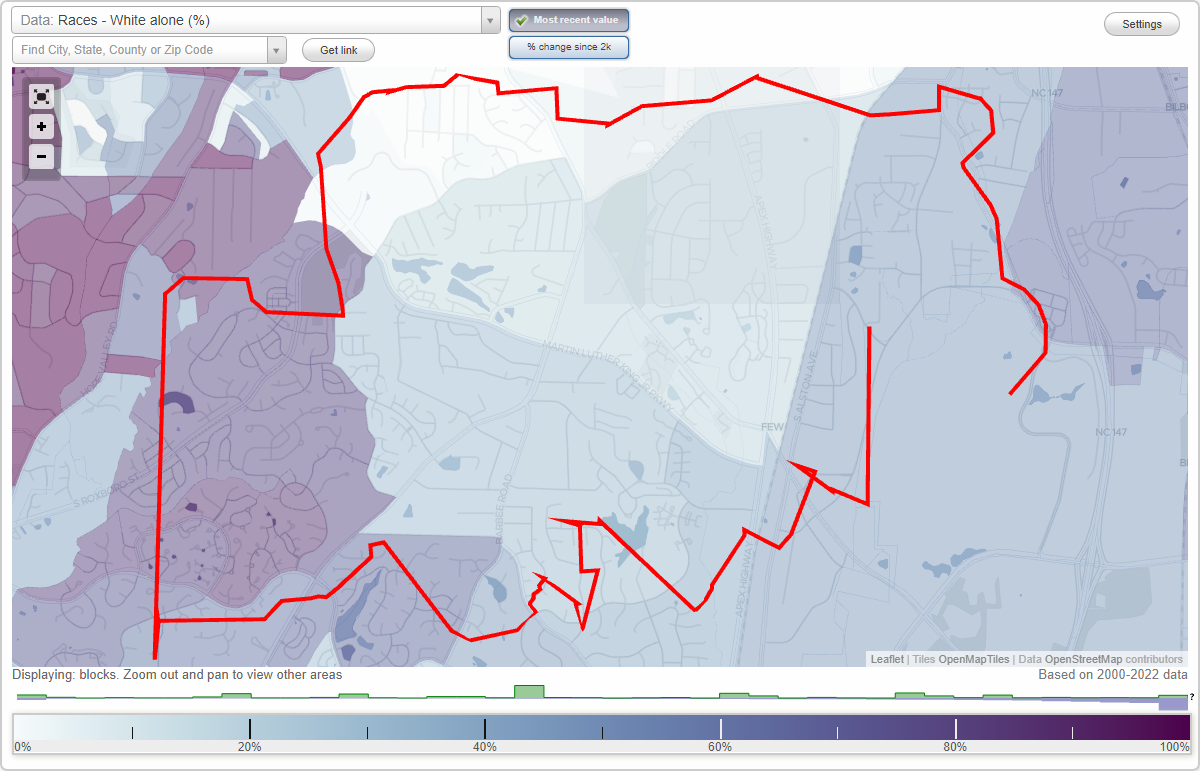
Research Triangle Park neighborhood in Durham, North Carolina (NC), 27560, 27709, 27713 detailed profile
Settings
X

Business Search - 14 Million verified businesses
Area: 8.316 square miles
City-data.com crime index for city in 2020 (higher means more crime):
| City: | 425.9 |
| U.S. average: | 219.5 |
Limited-access highways (interstate or state) in this neighborhood:
Durham Fwy (State Hwy 147)
Length: 6.80 miles
Directions: E-W, N-S, SW-NE
Directions: E-W, N-S, SW-NE
I- 40
Length: 3.97 miles
Directions: E-W, SE-NW
Directions: E-W, SE-NW
Highways in this neighborhood:
State Hwy 54 (E State Hwy 54)
Length: 2.64 miles
Directions: E-W, SE-NW
Address range: 2505 to 2599
Directions: E-W, SE-NW
Address range: 2505 to 2599
Roads and streets:
Alexander Dr (State Rd 2028, T W Alexander Dr)
Length: 4.85 miles
Directions: E-W, N-S, SW-NE
Directions: E-W, N-S, SW-NE
Moore Dr
Length: 2.67 miles
Directions: E-W, N-S, SE-NW, SW-NE
Directions: E-W, N-S, SE-NW, SW-NE
State Rd 1121 (E Cornwallis Rd)
Length: 2.15 miles
Directions: E-W, SE-NW
Directions: E-W, SE-NW
Davis Dr (State Rd 1999)
Length: 1.83 miles
Directions: E-W, N-S, SW-NE
Address range: 1 to 33
Directions: E-W, N-S, SW-NE
Address range: 1 to 33
Hopson Rd (State Rd 1978)
Length: 1.49 miles
Directions: E-W, N-S, SE-NW
Directions: E-W, N-S, SE-NW
State Rd 1975 (Jenkins Rd)
Length: 1.29 miles
Directions: N-S, SE-NW
Directions: N-S, SE-NW
Lakeview Dr
Length: 1.17 miles
Directions: E-W, N-S, SE-NW, SW-NE
Directions: E-W, N-S, SE-NW, SW-NE
E Institute Rd
Length: 0.94 miles
Directions: E-W, N-S, SE-NW, SW-NE
Directions: E-W, N-S, SE-NW, SW-NE
Park Dr
Length: 0.83 miles
Directions: E-W, N-S, SE-NW, SW-NE
Address range: 1 to 46
Directions: E-W, N-S, SE-NW, SW-NE
Address range: 1 to 46
Laboratory Dr
Length: 0.75 miles
Directions: E-W, N-S, SE-NW, SW-NE
Address range: 1 to 99
Directions: E-W, N-S, SE-NW, SW-NE
Address range: 1 to 99
W Institute Rd
Length: 0.68 miles
Directions: E-W, N-S, SE-NW, SW-NE
Directions: E-W, N-S, SE-NW, SW-NE
S Miami Blvd (State Rd 1959)
Length: 0.61 miles
Direction: N-S
Address range: 3702 to 3998
Direction: N-S
Address range: 3702 to 3998
Park Offices Dr
Length: 0.59 miles
Directions: E-W, N-S, SE-NW, SW-NE
Address range: 200 to 899
Directions: E-W, N-S, SE-NW, SW-NE
Address range: 200 to 899
State Rd 2068 (Triange Dr)
Length: 0.49 miles
Directions: E-W, SW-NE
Directions: E-W, SW-NE
So-Hi Dr
Length: 0.45 miles
Direction: E-W
Address range: 2162 to 2312
Direction: E-W
Address range: 2162 to 2312
Facilities Ln
Length: 0.44 miles
Direction: E-W
Direction: E-W
Environmental Pkwy
Length: 0.43 miles
Directions: E-W, N-S, SE-NW
Directions: E-W, N-S, SE-NW
Maughan Dr (State Rd 2078)
Length: 0.37 miles
Directions: E-W, SW-NE
Directions: E-W, SW-NE
N Park Ln
Length: 0.34 miles
Directions: E-W, N-S, SE-NW, SW-NE
Directions: E-W, N-S, SE-NW, SW-NE
State Rd 1990 (Hanes Dr)
Length: 0.27 miles
Directions: E-W, N-S, SE-NW
Directions: E-W, N-S, SE-NW
Estridge Dr
Length: 0.27 miles
Directions: N-S, SE-NW, SW-NE
Directions: N-S, SE-NW, SW-NE
Stones Throw Ln
Length: 0.15 miles
Direction: E-W
Address range: 3200 to 3243
Direction: E-W
Address range: 3200 to 3243
State Rd 1945 (S Alston Ave)
Length: 0.15 miles
Directions: E-W, N-S, SW-NE
Address range: 5800 to 5817
Directions: E-W, N-S, SW-NE
Address range: 5800 to 5817
S Park Ln
Length: 0.13 miles
Directions: E-W, SE-NW
Directions: E-W, SE-NW
Journal Ln
Length: 0.12 miles
Directions: E-W, N-S, SW-NE
Directions: E-W, N-S, SW-NE
Ellis Rd
Length: 0.12 miles
Direction: SE-NW
Address range: 1915 to 1999
Direction: SE-NW
Address range: 1915 to 1999
Nobel Ln
Length: 0.11 miles
Direction: E-W
Direction: E-W
Power Aly
Length: 0.10 miles
Direction: N-S
Address range: 105 to 108
Direction: N-S
Address range: 105 to 108
Gasoline Aly
Length: 0.09 miles
Direction: N-S
Direction: N-S
Warehouse Aly
Length: 0.08 miles
Direction: N-S
Address range: 102 to 105
Direction: N-S
Address range: 102 to 105
Research Ln
Length: 0.08 miles
Direction: E-W
Direction: E-W
State Rd 1121 (Cornwallis Rd)
Length: 0.06 miles
Direction: E-W
Direction: E-W
N Loop Rd
Length: 0.05 miles
Directions: E-W, N-S, SW-NE
Directions: E-W, N-S, SW-NE
Jester Rd (State Rd 2062)
Length: 0.04 miles
Direction: E-W
Address range: 1800 to 1828
Direction: E-W
Address range: 1800 to 1828
Railroad features:
Southern Rlwy
Length: 1.72 miles
Directions: N-S, SE-NW
Directions: N-S, SE-NW
Other features:
Burden Crk
Length: 1.95 miles
Directions: E-W, N-S, SE-NW, SW-NE
Directions: E-W, N-S, SE-NW, SW-NE
Burdens Crk
Length: 1.09 miles
Directions: E-W, N-S, SE-NW, SW-NE
Directions: E-W, N-S, SE-NW, SW-NE
Buck Br
Length: 0.51 miles
Directions: E-W, N-S, SE-NW, SW-NE
Directions: E-W, N-S, SE-NW, SW-NE