Whitehall (White Hall) neighborhood in Columbia, South Carolina (SC), 29210, 29212 detailed profile
Settings
X

Business Search - 14 Million verified businesses
Area: 3.237 square miles
Population: 9,858
Population density:
| Whitehall (White Hall): | 3,045 people per square mile |
| Columbia: | 1,113 people per square mile |

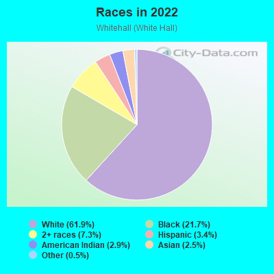
- 6,56061.9%White
- 2,29821.7%Black
- 7697.3%Two or more races
- 3563.4%Hispanic or Latino
- 3072.9%American Indian
- 2672.5%Asian
- 480.5%Some other race
Median household income in 2022:
| Whitehall (White Hall): | $54,014 |
| Columbia: | $56,175 |
Distribution of median household income
![Distribution of median household income]()
- 172Less than $10,000
- 314$10,000 to $19,999
- 357$20,000 to $29,999
- 745$30,000 to $39,999
- 619$40,000 to $49,999
- 719$50,000 to $59,999
- 420$60,000 to $74,999
- 754$75,000 to $99,999
- 489$100,000 to $124,999
- 217$125,000 to $149,999
- 209$150,000 to $199,999
- 154$200,000 or more

Distribution of owner-occupied house/condo value
![Distribution of owner-occupied house/condo value]()
- 342Less than $50,000
- 409$50,000 to $99,999
- 285$100,000 to $149,999
- 1,033$150,000 to $199,999
- 611$200,000 to $249,999
- 617$250,000 to $299,999
- 235$300,000 to $399,999
- 100$400,000 to $499,999
- 85$500,000 to $749,999
- 138$750,000 to $999,999

Distribution of rent paid by renters
![Distribution of rent paid by renters]()
- 79Less than $100
- 191$100 to $199
- 101$200 to $299
- 77$300 to $399
- 2$400 to $499
- 234$500 to $599
- 1,047$600 to $699
- 794$700 to $799
- 925$800 to $899
- 916$900 to $999
- 494$1,000 to $1,249
- 361$1,250 to $1,499
- 74$1,500 to $1,999
- 65$2,000 or more

| Males: | 4,758 |
| Females: | 5,099 |
Males:
| This neighborhood: | 34.7 years |
| Whole city: | 27.5 years |
| This neighborhood: | 34.3 years |
| Whole city: | 29.3 years |
Average household size:
| Whitehall (White Hall): | 4.3 people |
| Columbia: | 2.1 people |
Percentage of family households:
| Whitehall (White Hall): | 48.8% |
| Columbia: | 35.2% |
| Here: | 52.2% |
| Columbia: | 27.5% |
Percentage of married-couple families with children (among all households):
| Whitehall (White Hall): | 27.5% |
| Columbia: | 23.7% |
Percentage of single-mother households (among all households):
| Whitehall (White Hall): | 10.9% |
| Columbia: | 12.1% |
Percentage of never married males 15 years old and over:
Percentage of never married females 15 years old and over:
| Whitehall (White Hall): | 15.4% |
| Columbia: | 31.8% |
Percentage of never married females 15 years old and over:
| Whitehall (White Hall): | 21.8% |
| city: | 26.3% |
Percentage of people that speak English not well or not at all:
| Whitehall (White Hall): | 0.5% |
| Columbia: | 0.6% |
Percentage of people born in this state:
Percentage of people born in another U.S. state:
Percentage of native residents but born outside the U.S.:
Percentage of foreign born residents:
| Here: | 54.2% |
| Columbia: | 53.1% |
Percentage of people born in another U.S. state:
| Whitehall (White Hall): | 34.8% |
| Columbia: | 40.1% |
Percentage of native residents but born outside the U.S.:
| Here: | 2.3% |
| city: | 2.2% |
Percentage of foreign born residents:
| Here: | 8.7% |
| Columbia: | 4.6% |
Owner-occupied
Renter-occupied

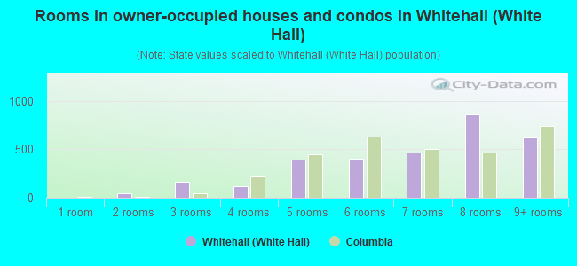
- Rooms in owner-occupied houses and condos in Whitehall <
> - 01 room
- 482 rooms
- 1633 rooms
- 1174 rooms
- 3925 rooms
- 4016 rooms
- 4637 rooms
- 8608 rooms
- 6269+ rooms
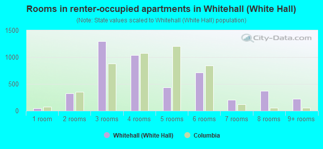
- Rooms in renter-occupied apartments in Whitehall <
> - 451 room
- 3232 rooms
- 1,2983 rooms
- 1,0394 rooms
- 4355 rooms
- 7116 rooms
- 2077 rooms
- 3748 rooms
- 2209+ rooms
Owner-occupied
Renter-occupied
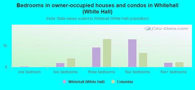
- Bedrooms in owner-occupied houses and condos in Whitehall <
> - 0no bedroom
- 481 bedroom
- 1912 bedrooms
- 9313 bedrooms
- 1,3114 bedrooms
- 2115+ bedrooms
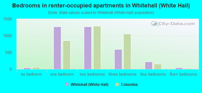
- Bedrooms in renter-occupied apartments in Whitehall <
> - 45no bedroom
- 1,2661 bedroom
- 1,2722 bedrooms
- 5963 bedrooms
- 2214 bedrooms
- 455+ bedrooms
Average number of cars or other vehicles available in houses/condos:
Average number of cars or other vehicles available in apartments:
| This neighborhood: | |
| Columbia: |
Average number of cars or other vehicles available in apartments:
| Here: | |
| city: |
Percentage of units with a mortgage:
| Whitehall (White Hall): | 75.3% |
| Columbia: | 67.5% |
Average estimated value of detached houses in 2022 (73.3% of all units):
| Whitehall (White Hall): | $212,781 |
| Columbia: | $305,357 |
- Year house built in Whitehall <
> - 162020 or later
- 902010 to 2019
- 1462000 to 2009
- 7151990 to 1999
- 5151980 to 1989
- 1,6681970 to 1979
- 1,2181960 to 1969
- 1541950 to 1959
- 261940 to 1949
- 141939 or earlier
City-data.com crime index for city in 2020 (higher means more crime):
| City: | 446.0 |
| U.S. average: | 219.5 |
Travel time to work (commute)
![Travel time to work (commute)]()
- 98Less than 5 minutes
- 3135 to 9 minutes
- 62910 to 14 minutes
- 1,37215 to 19 minutes
- 98620 to 24 minutes
- 38125 to 29 minutes
- 52330 to 34 minutes
- 6335 to 39 minutes
- 6740 to 44 minutes
- 10145 to 59 minutes
- 3360 to 89 minutes
- 7790 or more minutes

Means of transportation to work
![Means of transportation to work]()
- 76.5%3,821Drove a car alone
- 12.1%602Carpooled
- 6.4%319Bus
- 16.1%803Taxi
- 6.4%322Walked
- 9.4%467Other means
- 9.5%473Worked at home

Time leaving home to go to work
![Time leaving home to go to work]()
- 6912:00 a.m. to 4:59 a.m.
- 2965:00 a.m. to 5:29 a.m.
- 2615:30 a.m. to 5:59 a.m.
- 1916:00 a.m. to 6:29 a.m.
- 1,0506:30 a.m. to 6:59 a.m.
- 6407:00 a.m. to 7:29 a.m.
- 2787:30 a.m. to 7:59 a.m.
- 2728:00 a.m. to 8:29 a.m.
- 4858:30 a.m. to 8:59 a.m.
- 4659:00 a.m. to 9:59 a.m.
- 40910:00 a.m. to 10:59 a.m.
- 14211:00 a.m. to 11:59 a.m.
- 19612:00 p.m. to 3:59 p.m.
- 2334:00 p.m. to 11:59 p.m.

Occupations of males:
- Percentage of males in management occupations (except farmers):
Here: 7.0% city: 12.3%
- Percentage of males in business and financial operations occupations:
Here: 5.0% city: 4.6%
- Percentage of males in computer and mathematical occupations:
Here: 8.4% city: 3.7%
- Percentage of males in architecture and engineering occupations:
Here: 1.9% city: 2.3%
- Percentage of males in education, training, and library occupations:
Here: 1.9% city: 6.7%
- Percentage of males in service occupations:
Here: 22.7% city: 18.4%
- Percentage of males in sales and office occupations:
Here: 20.3% city: 16.6%
- Percentage of males in construction, extraction, and maintenance occupations:
Here: 1.6% city: 4.8%
- Percentage of males in production occupations:
Here: 3.5% city: 3.9%
- Percentage of males in transportation occupations:
Here: 14.2% city: 4.1%
Occupations of females:
- Percentage of females in management occupations (except farmers):
Here: 16.3% city: 8.8%
- Percentage of females in business and financial operations occupations:
Here: 2.5% city: 6.4%
- Percentage of females in computer and mathematical occupations:
Here: 4.0% city: 2.3%
- Percentage of females in community and social services occupations:
Here: 2.0% city: 2.6%
- Percentage of females in legal occupations:
Here: 1.6% city: 1.6%
- Percentage of females in education, training, and library occupations:
Here: 14.4% city: 11.5%
- Percentage of females in arts, design, entertainment, sports, and media occupations:
Here: 1.0% city: 2.6%
- Percentage of females in healthcare practitioners and technical occupations:
Here: 2.7% city: 8.7%
- Percentage of females in service occupations:
Here: 12.4% city: 20.2%
- Percentage of females in sales and office occupations:
Here: 39.6% city: 26.9%
- Percentage of females in material moving occupations:
Here: 2.2% city: 1.7%
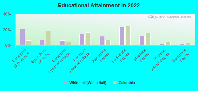
Education in this neighborhood (subdivision or community):
- Percentage of people 3 years and older in K-12 schools:
Whitehall (White Hall): 17.3% Columbia: 12.2%
- Percentage of people 3 years and older in undergraduate colleges:
Whitehall (White Hall): 5.3% Columbia: 16.2%
- Percentage of people 3 years and older in grad. or professional schools:
Whitehall (White Hall): 2.6% Columbia: 3.5%
- Percentage of students K-12 enrolled in private schools:
Whitehall (White Hall): 15.4% Columbia: 24.2%
Percentage of population below poverty level:
| Whitehall (White Hall): | 7.5% |
| Columbia: | 20.7% |
Percentage of married-couple families with both working:
| Whitehall (White Hall): | 101.2% |
| Columbia: | 72.3% |
- 70.8%Electricity
- 26.0%Utility gas
- 2.4%Solar energy
- 0.8%Bottled, tank, or LP gas
Limited-access highways (interstate or state) in this neighborhood:
I- 26 (US Hwy 76)
Length: 6.26 miles
Direction: SE-NW
Address range: 689 to 799
Direction: SE-NW
Address range: 689 to 799
US Hwy 76
Length: 0.12 miles
Direction: SE-NW
Direction: SE-NW
Roads and streets:
Jamil Rd
Length: 3.39 miles
Directions: E-W, N-S, SE-NW, SW-NE
Address range: 100 to 899
Directions: E-W, N-S, SE-NW, SW-NE
Address range: 100 to 899
Saint Andrews Rd
Length: 2.71 miles
Directions: E-W, SE-NW
Address range: 100 to 6361
Directions: E-W, SE-NW
Address range: 100 to 6361
Piney Grove Rd
Length: 1.60 miles
Directions: E-W, SW-NE
Address range: 100 to 1265
Directions: E-W, SW-NE
Address range: 100 to 1265
Tram Rd
Length: 1.42 miles
Directions: E-W, N-S, SW-NE
Address range: 100 to 599
Directions: E-W, N-S, SW-NE
Address range: 100 to 599
Bower Pkwy
Length: 1.10 miles
Directions: E-W, SE-NW, SW-NE
Address range: 1006 to 1299
Directions: E-W, SE-NW, SW-NE
Address range: 1006 to 1299
State Rd S-32-36 (St Andrews Rd)
Length: 0.95 miles
Directions: N-S, SE-NW, SW-NE
Address range: 6100 to 6598
Directions: N-S, SE-NW, SW-NE
Address range: 6100 to 6598
Lockner Rd
Length: 0.94 miles
Directions: E-W, N-S, SE-NW
Address range: 300 to 999
Directions: E-W, N-S, SE-NW
Address range: 300 to 999
Townes Rd
Length: 0.91 miles
Directions: E-W, N-S, SE-NW, SW-NE
Address range: 100 to 899
Directions: E-W, N-S, SE-NW, SW-NE
Address range: 100 to 899
Nottingham Rd
Length: 0.82 miles
Directions: E-W, SE-NW
Address range: 100 to 599
Directions: E-W, SE-NW
Address range: 100 to 599
Shadow Brook Dr
Length: 0.76 miles
Directions: N-S, SE-NW, SW-NE
Address range: 500 to 999
Directions: N-S, SE-NW, SW-NE
Address range: 500 to 999
Broken Hill Rd
Length: 0.67 miles
Directions: E-W, N-S, SE-NW
Address range: 100 to 699
Directions: E-W, N-S, SE-NW
Address range: 100 to 699
Sidney Rd
Length: 0.64 miles
Directions: N-S, SE-NW
Address range: 3101 to 3799
Directions: N-S, SE-NW
Address range: 3101 to 3799
Leisure Ln
Length: 0.63 miles
Direction: SE-NW
Address range: 100 to 299
Direction: SE-NW
Address range: 100 to 299
Brookshire Rd
Length: 0.63 miles
Directions: N-S, SE-NW, SW-NE
Address range: 203 to 631
Directions: N-S, SE-NW, SW-NE
Address range: 203 to 631
Sandhurst Rd
Length: 0.61 miles
Directions: E-W, SE-NW, SW-NE
Address range: 100 to 299
Directions: E-W, SE-NW, SW-NE
Address range: 100 to 299
Garmony Rd
Length: 0.61 miles
Directions: E-W, N-S, SE-NW, SW-NE
Address range: 100 to 699
Directions: E-W, N-S, SE-NW, SW-NE
Address range: 100 to 699
Leton Dr
Length: 0.61 miles
Directions: E-W, SW-NE
Address range: 200 to 499
Directions: E-W, SW-NE
Address range: 200 to 499
Old Friars Rd
Length: 0.60 miles
Directions: N-S, SE-NW, SW-NE
Address range: 400 to 799
Directions: N-S, SE-NW, SW-NE
Address range: 400 to 799
Rhett Rd
Length: 0.56 miles
Directions: E-W, N-S, SW-NE
Address range: 200 to 298
Directions: E-W, N-S, SW-NE
Address range: 200 to 298
Pitney Rd
Length: 0.56 miles
Directions: E-W, N-S, SE-NW, SW-NE
Address range: 200 to 599
Directions: E-W, N-S, SE-NW, SW-NE
Address range: 200 to 599
Baffin Bay Rd
Length: 0.55 miles
Direction: SW-NE
Address range: 700 to 1399
Direction: SW-NE
Address range: 700 to 1399
Seton Rd
Length: 0.54 miles
Directions: E-W, SW-NE
Address range: 700 to 999
Directions: E-W, SW-NE
Address range: 700 to 999
Valcour Rd
Length: 0.53 miles
Directions: E-W, N-S, SE-NW
Address range: 100 to 399
Directions: E-W, N-S, SE-NW
Address range: 100 to 399
Challedon Dr
Length: 0.52 miles
Directions: E-W, SW-NE
Address range: 400 to 799
Directions: E-W, SW-NE
Address range: 400 to 799
Sulgrave Dr
Length: 0.51 miles
Directions: E-W, N-S, SE-NW, SW-NE
Address range: 400 to 599
Directions: E-W, N-S, SE-NW, SW-NE
Address range: 400 to 599
Pittsdowne Rd
Length: 0.50 miles
Directions: N-S, SW-NE
Address range: 300 to 599
Directions: N-S, SW-NE
Address range: 300 to 599
Willow Winds Dr
Length: 0.49 miles
Directions: E-W, N-S, SE-NW, SW-NE
Address range: 100 to 415
Directions: E-W, N-S, SE-NW, SW-NE
Address range: 100 to 415
Stirlington Rd
Length: 0.48 miles
Directions: E-W, N-S, SE-NW, SW-NE
Address range: 100 to 499
Directions: E-W, N-S, SE-NW, SW-NE
Address range: 100 to 499
Harrow Dr
Length: 0.47 miles
Directions: E-W, N-S, SE-NW, SW-NE
Address range: 300 to 799
Directions: E-W, N-S, SE-NW, SW-NE
Address range: 300 to 799
Lewisham Rd
Length: 0.46 miles
Directions: N-S, SE-NW, SW-NE
Address range: 300 to 699
Directions: N-S, SE-NW, SW-NE
Address range: 300 to 699
Fox Fire Dr
Length: 0.46 miles
Directions: E-W, SE-NW
Address range: 300 to 332
Directions: E-W, SE-NW
Address range: 300 to 332
Banbury Rd
Length: 0.46 miles
Directions: E-W, N-S, SE-NW, SW-NE
Address range: 100 to 299
Directions: E-W, N-S, SE-NW, SW-NE
Address range: 100 to 299
Paris Rd
Length: 0.45 miles
Directions: E-W, N-S, SE-NW
Address range: 300 to 463
Directions: E-W, N-S, SE-NW
Address range: 300 to 463
Middlesex Rd
Length: 0.45 miles
Directions: E-W, SE-NW
Address range: 200 to 299
Directions: E-W, SE-NW
Address range: 200 to 299
Lockshire Rd
Length: 0.44 miles
Directions: E-W, SE-NW, SW-NE
Address range: 200 to 599
Directions: E-W, SE-NW, SW-NE
Address range: 200 to 599
Landmark Dr
Length: 0.44 miles
Directions: E-W, N-S, SE-NW, SW-NE
Address range: 1 to 99
Directions: E-W, N-S, SE-NW, SW-NE
Address range: 1 to 99
Shareditch Rd
Length: 0.41 miles
Directions: N-S, SW-NE
Address range: 101 to 399
Directions: N-S, SW-NE
Address range: 101 to 399
Kettering Dr
Length: 0.41 miles
Directions: E-W, SE-NW, SW-NE
Address range: 400 to 699
Directions: E-W, SE-NW, SW-NE
Address range: 400 to 699
Oberlin Rd
Length: 0.41 miles
Directions: E-W, SE-NW
Address range: 1 to 299
Directions: E-W, SE-NW
Address range: 1 to 299
Biddle Rd
Length: 0.40 miles
Directions: E-W, N-S, SE-NW
Address range: 200 to 499
Directions: E-W, N-S, SE-NW
Address range: 200 to 499
Loch Rd
Length: 0.39 miles
Directions: E-W, SE-NW, SW-NE
Address range: 100 to 299
Directions: E-W, SE-NW, SW-NE
Address range: 100 to 299
King George Way
Length: 0.39 miles
Directions: E-W, N-S, SE-NW, SW-NE
Address range: 100 to 199
Directions: E-W, N-S, SE-NW, SW-NE
Address range: 100 to 199
N Stonehedge Dr
Length: 0.38 miles
Directions: E-W, SW-NE
Address range: 200 to 399
Directions: E-W, SW-NE
Address range: 200 to 399
Chippenham Cir
Length: 0.38 miles
Directions: E-W, N-S, SE-NW, SW-NE
Address range: 100 to 199
Directions: E-W, N-S, SE-NW, SW-NE
Address range: 100 to 199
Tyborne Cir
Length: 0.36 miles
Directions: SE-NW, SW-NE
Address range: 100 to 299
Directions: SE-NW, SW-NE
Address range: 100 to 299
S Stonehedge Dr
Length: 0.36 miles
Directions: E-W, N-S, SE-NW, SW-NE
Address range: 300 to 399
Directions: E-W, N-S, SE-NW, SW-NE
Address range: 300 to 399
Fernandina Rd
Length: 0.35 miles
Direction: SE-NW
Address range: 3780 to 3871
Direction: SE-NW
Address range: 3780 to 3871
Barmount Dr
Length: 0.35 miles
Direction: SW-NE
Address range: 100 to 399
Direction: SW-NE
Address range: 100 to 399
Linsbury Cir
Length: 0.35 miles
Directions: E-W, N-S, SE-NW, SW-NE
Address range: 100 to 399
Directions: E-W, N-S, SE-NW, SW-NE
Address range: 100 to 399
Forest Grove Ln
Length: 0.35 miles
Directions: N-S, SE-NW, SW-NE
Address range: 200 to 399
Directions: N-S, SE-NW, SW-NE
Address range: 200 to 399
Silvermill Rd
Length: 0.34 miles
Directions: E-W, SE-NW
Address range: 100 to 199
Directions: E-W, SE-NW
Address range: 100 to 199
Shelton Dr
Length: 0.34 miles
Directions: E-W, SW-NE
Address range: 400 to 599
Directions: E-W, SW-NE
Address range: 400 to 599
Quincannon Dr (Quincannon Rd)
Length: 0.33 miles
Directions: E-W, SE-NW, SW-NE
Address range: 200 to 399
Directions: E-W, SE-NW, SW-NE
Address range: 200 to 399
Park Terrace Dr
Length: 0.33 miles
Directions: N-S, SE-NW
Address range: 100 to 399
Directions: N-S, SE-NW
Address range: 100 to 399
Vincenne Rd
Length: 0.32 miles
Directions: E-W, N-S, SE-NW
Address range: 200 to 499
Directions: E-W, N-S, SE-NW
Address range: 200 to 499
Brookshire Dr
Length: 0.31 miles
Directions: E-W, SW-NE
Directions: E-W, SW-NE
Islay Ln
Length: 0.31 miles
Directions: E-W, SW-NE
Address range: 1 to 199
Directions: E-W, SW-NE
Address range: 1 to 199
Stromsdale Rd
Length: 0.31 miles
Direction: SE-NW
Address range: 400 to 599
Direction: SE-NW
Address range: 400 to 599
Hempsted Rd
Length: 0.30 miles
Directions: N-S, SE-NW, SW-NE
Address range: 300 to 499
Directions: N-S, SE-NW, SW-NE
Address range: 300 to 499
Tudor Rd
Length: 0.29 miles
Directions: E-W, SW-NE
Address range: 200 to 399
Directions: E-W, SW-NE
Address range: 200 to 399
Limehouse Reach Rd
Length: 0.29 miles
Directions: E-W, SE-NW
Address range: 100 to 199
Directions: E-W, SE-NW
Address range: 100 to 199
Ambling Cir
Length: 0.27 miles
Directions: E-W, N-S, SE-NW, SW-NE
Address range: 200 to 299
Directions: E-W, N-S, SE-NW, SW-NE
Address range: 200 to 299
Biscayne Rd
Length: 0.26 miles
Directions: E-W, SW-NE
Address range: 300 to 499
Directions: E-W, SW-NE
Address range: 300 to 499
Winstaire Dr
Length: 0.25 miles
Directions: E-W, SW-NE
Address range: 400 to 499
Directions: E-W, SW-NE
Address range: 400 to 499
Southwell Rd
Length: 0.25 miles
Directions: E-W, N-S, SE-NW, SW-NE
Address range: 100 to 199
Directions: E-W, N-S, SE-NW, SW-NE
Address range: 100 to 199
Lydgate Dr
Length: 0.24 miles
Directions: N-S, SE-NW
Address range: 300 to 499
Directions: N-S, SE-NW
Address range: 300 to 499
Baymore Ln
Length: 0.24 miles
Directions: N-S, SE-NW
Address range: 200 to 499
Directions: N-S, SE-NW
Address range: 200 to 499
Wexwood Rd
Length: 0.23 miles
Directions: N-S, SW-NE
Address range: 300 to 399
Directions: N-S, SW-NE
Address range: 300 to 399
Cheshire Dr
Length: 0.22 miles
Directions: E-W, N-S, SE-NW, SW-NE
Address range: 100 to 199
Directions: E-W, N-S, SE-NW, SW-NE
Address range: 100 to 199
Wilkshire Dr
Length: 0.22 miles
Directions: E-W, N-S, SE-NW, SW-NE
Address range: 100 to 599
Directions: E-W, N-S, SE-NW, SW-NE
Address range: 100 to 599
Bay Rd
Length: 0.22 miles
Directions: SE-NW, SW-NE
Address range: 1210 to 1499
Directions: SE-NW, SW-NE
Address range: 1210 to 1499
Trafalgar Dr
Length: 0.21 miles
Directions: E-W, N-S, SE-NW, SW-NE
Address range: 700 to 799
Directions: E-W, N-S, SE-NW, SW-NE
Address range: 700 to 799
Forest Grove Cir
Length: 0.21 miles
Directions: E-W, N-S, SE-NW, SW-NE
Address range: 400 to 499
Directions: E-W, N-S, SE-NW, SW-NE
Address range: 400 to 499
Massingale Rd
Length: 0.21 miles
Directions: N-S, SE-NW, SW-NE
Address range: 300 to 399
Directions: N-S, SE-NW, SW-NE
Address range: 300 to 399
Kilbranan Dr
Length: 0.20 miles
Directions: E-W, N-S, SW-NE
Address range: 1 to 98
Directions: E-W, N-S, SW-NE
Address range: 1 to 98
Paisley Ln
Length: 0.20 miles
Directions: E-W, N-S, SE-NW, SW-NE
Address range: 1 to 99
Directions: E-W, N-S, SE-NW, SW-NE
Address range: 1 to 99
Lambeth Ct
Length: 0.19 miles
Directions: E-W, N-S, SW-NE
Address range: 300 to 399
Directions: E-W, N-S, SW-NE
Address range: 300 to 399
Flint St
Length: 0.19 miles
Directions: E-W, SE-NW
Address range: 400 to 499
Directions: E-W, SE-NW
Address range: 400 to 499
Fredricksburg Way
Length: 0.19 miles
Directions: N-S, SE-NW
Address range: 100 to 199
Directions: N-S, SE-NW
Address range: 100 to 199
Valmire Dr
Length: 0.18 miles
Directions: E-W, N-S, SE-NW, SW-NE
Address range: 500 to 599
Directions: E-W, N-S, SE-NW, SW-NE
Address range: 500 to 599
Garmony Cir
Length: 0.17 miles
Directions: E-W, N-S, SE-NW, SW-NE
Address range: 100 to 199
Directions: E-W, N-S, SE-NW, SW-NE
Address range: 100 to 199
E Nottingham Rd
Length: 0.17 miles
Directions: E-W, N-S, SW-NE
Address range: 200 to 227
Directions: E-W, N-S, SW-NE
Address range: 200 to 227
Northman Dr
Length: 0.17 miles
Direction: SE-NW
Address range: 100 to 199
Direction: SE-NW
Address range: 100 to 199
Bridgeton Rd
Length: 0.17 miles
Directions: N-S, SE-NW, SW-NE
Address range: 100 to 199
Directions: N-S, SE-NW, SW-NE
Address range: 100 to 199
Tartan Rd
Length: 0.16 miles
Directions: E-W, SE-NW
Address range: 200 to 299
Directions: E-W, SE-NW
Address range: 200 to 299
Dorset Dr
Length: 0.15 miles
Directions: E-W, N-S, SE-NW, SW-NE
Address range: 100 to 199
Directions: E-W, N-S, SE-NW, SW-NE
Address range: 100 to 199
Stratton Ct
Length: 0.15 miles
Directions: E-W, SE-NW
Address range: 100 to 199
Directions: E-W, SE-NW
Address range: 100 to 199
Yarmouth Dr
Length: 0.14 miles
Direction: SE-NW
Address range: 300 to 399
Direction: SE-NW
Address range: 300 to 399
Lingstrom Ln
Length: 0.14 miles
Directions: N-S, SW-NE
Address range: 200 to 299
Directions: N-S, SW-NE
Address range: 200 to 299
Keswick Rd
Length: 0.14 miles
Directions: E-W, SE-NW
Address range: 500 to 599
Directions: E-W, SE-NW
Address range: 500 to 599
Sarmount Dr
Length: 0.14 miles
Directions: E-W, N-S, SE-NW, SW-NE
Address range: 100 to 112
Directions: E-W, N-S, SE-NW, SW-NE
Address range: 100 to 112
Ardmont Rd
Length: 0.13 miles
Directions: E-W, SE-NW
Address range: 200 to 299
Directions: E-W, SE-NW
Address range: 200 to 299
Holburn Ct
Length: 0.13 miles
Directions: E-W, N-S, SW-NE
Address range: 100 to 198
Directions: E-W, N-S, SW-NE
Address range: 100 to 198
Drury Ln
Length: 0.13 miles
Direction: SW-NE
Address range: 100 to 199
Direction: SW-NE
Address range: 100 to 199
Alton Pl
Length: 0.12 miles
Directions: N-S, SW-NE
Address range: 200 to 299
Directions: N-S, SW-NE
Address range: 200 to 299
Argyll Rd
Length: 0.12 miles
Directions: N-S, SE-NW, SW-NE
Address range: 200 to 299
Directions: N-S, SE-NW, SW-NE
Address range: 200 to 299
Railfence Dr
Length: 0.12 miles
Direction: SE-NW
Direction: SE-NW
Myton Rd
Length: 0.12 miles
Directions: E-W, SE-NW
Address range: 400 to 499
Directions: E-W, SE-NW
Address range: 400 to 499
Conover Rd
Length: 0.11 miles
Direction: E-W
Address range: 300 to 399
Direction: E-W
Address range: 300 to 399
State Rd S-32-2272 (Harbison Blvd)
Length: 0.11 miles
Direction: SW-NE
Address range: 102 to 125
Direction: SW-NE
Address range: 102 to 125
Nottingham Ct
Length: 0.10 miles
Directions: SE-NW, SW-NE
Address range: 100 to 199
Directions: SE-NW, SW-NE
Address range: 100 to 199
Lance Dr
Length: 0.10 miles
Directions: N-S, SE-NW
Address range: 500 to 599
Directions: N-S, SE-NW
Address range: 500 to 599
Whittington Ct
Length: 0.10 miles
Directions: E-W, SE-NW
Address range: 200 to 299
Directions: E-W, SE-NW
Address range: 200 to 299
Royal Woods Rd
Length: 0.10 miles
Direction: SE-NW
Address range: 100 to 124
Direction: SE-NW
Address range: 100 to 124
Kersey Rd
Length: 0.10 miles
Direction: SW-NE
Address range: 200 to 299
Direction: SW-NE
Address range: 200 to 299
Challedon Ct
Length: 0.10 miles
Directions: E-W, SE-NW
Address range: 300 to 399
Directions: E-W, SE-NW
Address range: 300 to 399
Dumbarton Rd
Length: 0.09 miles
Direction: SW-NE
Address range: 900 to 999
Direction: SW-NE
Address range: 900 to 999
Whitcomb Dr
Length: 0.09 miles
Direction: E-W
Direction: E-W
Wexwood Ct
Length: 0.09 miles
Direction: E-W
Address range: 100 to 355
Direction: E-W
Address range: 100 to 355
Touring Rd
Length: 0.09 miles
Direction: SW-NE
Address range: 200 to 299
Direction: SW-NE
Address range: 200 to 299
Blythecreek Ct
Length: 0.09 miles
Directions: N-S, SE-NW
Address range: 200 to 299
Directions: N-S, SE-NW
Address range: 200 to 299
Palace Green Ct
Length: 0.08 miles
Direction: E-W
Address range: 100 to 199
Direction: E-W
Address range: 100 to 199
Stepney Ct
Length: 0.07 miles
Direction: N-S
Address range: 300 to 399
Direction: N-S
Address range: 300 to 399
Lockner Cir
Length: 0.07 miles
Directions: E-W, N-S, SE-NW, SW-NE
Address range: 600 to 699
Directions: E-W, N-S, SE-NW, SW-NE
Address range: 600 to 699
Kettering Ct
Length: 0.07 miles
Directions: E-W, N-S, SE-NW, SW-NE
Address range: 428 to 431
Directions: E-W, N-S, SE-NW, SW-NE
Address range: 428 to 431
Lockner Ct
Length: 0.06 miles
Direction: E-W
Address range: 300 to 399
Direction: E-W
Address range: 300 to 399
Rutherglen Ct
Length: 0.06 miles
Direction: N-S
Address range: 1 to 99
Direction: N-S
Address range: 1 to 99
Lewisham Ct
Length: 0.06 miles
Direction: SE-NW
Address range: 500 to 599
Direction: SE-NW
Address range: 500 to 599
Lockshire Cir
Length: 0.05 miles
Directions: E-W, SW-NE
Address range: 400 to 499
Directions: E-W, SW-NE
Address range: 400 to 499
Tram Ct
Length: 0.05 miles
Direction: SE-NW
Address range: 100 to 199
Direction: SE-NW
Address range: 100 to 199
Silvermill Ct
Length: 0.04 miles
Direction: SW-NE
Address range: 200 to 299
Direction: SW-NE
Address range: 200 to 299
Rose Hill Ct
Length: 0.04 miles
Direction: SE-NW
Address range: 1 to 99
Direction: SE-NW
Address range: 1 to 99
William and Mary Ct
Length: 0.04 miles
Directions: E-W, SW-NE
Address range: 1100 to 1199
Directions: E-W, SW-NE
Address range: 1100 to 1199
Kinley Creek Rd
Length: 0.04 miles
Direction: SW-NE
Address range: 116 to 149
Direction: SW-NE
Address range: 116 to 149
Myton Ct
Length: 0.03 miles
Direction: E-W
Address range: 100 to 199
Direction: E-W
Address range: 100 to 199
Tendrill Ct
Length: 0.03 miles
Direction: E-W
Address range: 200 to 399
Direction: E-W
Address range: 200 to 399
Ferntree Ct
Length: 0.03 miles
Direction: SE-NW
Address range: 100 to 199
Direction: SE-NW
Address range: 100 to 199
Tyborne Ct
Length: 0.03 miles
Direction: SE-NW
Address range: 100 to 199
Direction: SE-NW
Address range: 100 to 199
Queen Anne Ct
Length: 0.03 miles
Direction: SW-NE
Address range: 100 to 199
Direction: SW-NE
Address range: 100 to 199
Ascot Ct
Length: 0.03 miles
Direction: E-W
Address range: 100 to 199
Direction: E-W
Address range: 100 to 199
Lockshire Ct
Length: 0.03 miles
Direction: N-S
Address range: 100 to 199
Direction: N-S
Address range: 100 to 199
Railroad features:
Columbia Newberry and Laurens RR
Length: 1.29 miles
Direction: SE-NW
Direction: SE-NW
Other features:
Kinley Crk
Length: 3.46 miles
Directions: E-W, N-S, SE-NW, SW-NE
Directions: E-W, N-S, SE-NW, SW-NE
Stoop Crk
Length: 0.45 miles
Directions: E-W, N-S, SE-NW, SW-NE
Directions: E-W, N-S, SE-NW, SW-NE
Limited-access highways (interstate or state) in this neighborhood:
I- 26 (US Hwy 76, James F Byrnes Expy)
Length: 0.07 miles
Directions: E-W, SE-NW
Directions: E-W, SE-NW