Bridge Statistics for Glen Burnie, Maryland (MD)
Condition, Traffic, Stress, Structural Evaluation, Project Costs
- National Bridge Inventory (NBI) Statistics
- 52Number of bridges
- 495ft / 151mTotal length
- $2,760,000Total costs
- 1,526,342Total average daily traffic
- 85,287Total average daily truck traffic
- National Bridge Inventory (NBI) Registered Bridges for Glen Burnie
- No street view available for this location
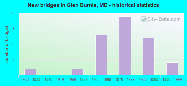
- New bridges - historical statistics
- 21930-1939
- 21950-1959
- 131960-1969
- 191970-1979
- 121980-1989
- 41990-1999

- Reconstructed bridges - Historical Statistics
- 11960-1969
- 11970-1979
- 01980-1989
- 11990-1999


- Bridge Condition - Deck
- 30.0%Good
- 65.0%Satisfactory
- 5.0%Fair

- Bridge Condition - Superstructure
- 50.0%Good
- 45.0%Satisfactory
- 5.0%Fair

- Bridge Condition - Substructure
- 30.0%Good
- 60.0%Satisfactory
- 10.0%Fair

- Bridge Condition - Channel
- 23.8%Good
- 71.4%Satisfactory
- 4.8%Fair

- Bridge Condition - Culverts
- 62.5%Satisfactory
- 37.5%Fair
Find on map >> Show street view
Structure Number: 10000002000601, Location: 0.09 MI N OF MD 270 (Lat: 39.182931, Lng: -76.612900), Route carried "on" structure: State highway 2, Year Built: 1937, Year Reconstructed: 1990, Status: Open, Structure Length: 1.13m (3.71ft), Average Daily Traffic: 31,511 (year 2009), Truck Traffic: 8%, Average Future Daily Traffic: 35,583 (year 2026), Design Load: HS 20, Features Intersected: SAWMILL CREEK
Minimum Vertical Clearance: 30+ m (98+ ft), Kilometerpoint: 60.885, Lanes on structure: 4, Base Highway Network: Yes, Owner: State Highway Agency, Approaching Roadway Width: 34.4m (112.9ft), Skew: 20 degrees, Material/Design: Prestressed concrete, Design/Construction: Slab, Number Of Spans In Main Unit: 1, Length of Maximum Span: 10.4m (34.1ft), Curb-To-Curb Width: 33.8m (110.9ft), Out-to-Out Width: 34.8m (114.2ft)
Condition: Deck: Good, Superstructure: Good, Substructure: Good, Channel: Satisfactory, Operating Rating: 69.8 metric tons, Method Used To Determine Operating Rating: Load Factor (LF), Inventory Rating: 38.1 metric tons, Method Used To Determine Inventory Rating: Load Factor (LF), Structural Evaluation: Better than present minimum criteria, Deck Geometry: Superior to present desirable criteria, Waterway Adequacy: Superior to present desirable criteria, Approach Roadway Alignment: Equal to present desirable criteria, Designated Inspection Frequency: Every 24 months, Inspection Date: June 2021, Deck Structure Type: Concrete Cast-file-Place, Wearing Surface/Protective System: Wearing Surface: Integral Concrete
Find on map >> Show street view
Structure Number: 100000020084014, Location: 0.54 MILE EAST OF MD 174 (Lat: 39.144531, Lng: -76.631217), Route carried "on" structure: State highway 100, Year Built: 1963, Status: Open, Structure Length: 6.43m (21.10ft), Average Daily Traffic: 75,406 (year 2009), Truck Traffic: 8%, Average Future Daily Traffic: 42,423 (year 2026), Design Load: HS 20, Features Intersected: MD 3 BUS
Minimum Vertical Clearance: 30+ m (98+ ft), Kilometerpoint: 12.129, Lanes on structure: 2, Lanes under structure: 4, Base Highway Network: Yes, Owner: State Highway Agency, Approaching Roadway Width: 12.2m (40.0ft), Skew: 3 degrees, Material/Design: Steel, Design/Construction: Stringer/Multi-beam, Number Of Spans In Main Unit: 4, Length of Maximum Span: 19.8m (65.0ft), Curb-To-Curb Width: 9.1m (29.9ft), Out-to-Out Width: 10.7m (35.1ft)
Condition: Deck: Satisfactory, Superstructure: Satisfactory, Substructure: Satisfactory, Operating Rating: 85.7 metric tons, Method Used To Determine Operating Rating: Load Factor (LF), Inventory Rating: 51.2 metric tons, Method Used To Determine Inventory Rating: Load Factor (LF), Structural Evaluation: Equal to present minimum criteria, Deck Geometry: Meets minimum limits, Underclear: Somewhat better than minimum adequacy, Approach Roadway Alignment: Equal to present desirable criteria, Length Of Structure Improvement: 6.43m (21.10ft), Designated Inspection Frequency: Every 24 months, Inspection Date: August 2020, Bridge Improvement Cost: $446,000, Roadway Improvement Cost: $45,000, Total Project Cost: $491,000, Deck Structure Type: Concrete Cast-file-Place, Wearing Surface/Protective System: Wearing Surface: Bituminous
Find on map >> Show street view
Structure Number: 100000020085013, Location: 0.82 MILE EAST OF MD 3BU (Lat: 39.139539, Lng: -76.618847), Route carried "on" structure: State highway 100, Year Built: 1963, Status: Open, Structure Length: 3.87m (12.70ft), Average Daily Traffic: 35,961 (year 2006), Truck Traffic: 8%, Average Future Daily Traffic: 41,463 (year 2026), Design Load: HS 20, Features Intersected: OAKWOOD ROAD
Minimum Vertical Clearance: 30+ m (98+ ft), Kilometerpoint: 13.464, Lanes on structure: 2, Lanes under structure: 4, Base Highway Network: Yes, Owner: State Highway Agency, Approaching Roadway Width: 12.2m (40.0ft), Material/Design: Steel, Design/Construction: Stringer/Multi-beam, Number Of Spans In Main Unit: 3, Length of Maximum Span: 25.3m (83.0ft), Curb-To-Curb Width: 9.1m (29.9ft), Out-to-Out Width: 10.7m (35.1ft)
Condition: Deck: Satisfactory, Superstructure: Satisfactory, Substructure: Satisfactory, Operating Rating: 67.6 metric tons, Method Used To Determine Operating Rating: Load Factor (LF), Inventory Rating: 40.4 metric tons, Method Used To Determine Inventory Rating: Load Factor (LF), Structural Evaluation: Equal to present minimum criteria, Deck Geometry: High priority of replacement, Underclear: High priority of replacement, Approach Roadway Alignment: Equal to present desirable criteria, Length Of Structure Improvement: 3.87m (12.70ft), Designated Inspection Frequency: Every 24 months, Inspection Date: August 2020, Bridge Improvement Cost: $536,000, Roadway Improvement Cost: $54,000, Total Project Cost: $590,000, Deck Structure Type: Concrete Cast-file-Place, Wearing Surface/Protective System: Wearing Surface: Bituminous
Find on map >> Show street view
Structure Number: 100000020085014, Location: 0.82 MILE EAST OF MD 3BU (Lat: 39.139811, Lng: -76.618336), Route carried "on" structure: State highway 100, Year Built: 1963, Status: Open, Structure Length: 3.99m (13.09ft), Average Daily Traffic: 35,961 (year 2006), Truck Traffic: 8%, Average Future Daily Traffic: 41,463 (year 2026), Design Load: HS 20, Features Intersected: OAKWOOD ROAD
Minimum Vertical Clearance: 30+ m (98+ ft), Kilometerpoint: 13.464, Lanes on structure: 2, Lanes under structure: 4, Base Highway Network: Yes, Owner: State Highway Agency, Approaching Roadway Width: 12.2m (40.0ft), Material/Design: Steel, Design/Construction: Stringer/Multi-beam, Number Of Spans In Main Unit: 3, Length of Maximum Span: 25.3m (83.0ft), Curb-To-Curb Width: 9.1m (29.9ft), Out-to-Out Width: 10.7m (35.1ft)
Condition: Deck: Satisfactory, Superstructure: Satisfactory, Substructure: Satisfactory, Operating Rating: 62.6 metric tons, Method Used To Determine Operating Rating: Load Factor (LF), Inventory Rating: 37.6 metric tons, Method Used To Determine Inventory Rating: Load Factor (LF), Structural Evaluation: Equal to present minimum criteria, Deck Geometry: High priority of replacement, Underclear: High priority of replacement, Approach Roadway Alignment: Equal to present desirable criteria, Length Of Structure Improvement: 3.99m (13.09ft), Designated Inspection Frequency: Every 24 months, Inspection Date: August 2020, Bridge Improvement Cost: $553,000, Roadway Improvement Cost: $55,000, Total Project Cost: $608,000, Deck Structure Type: Concrete Cast-file-Place, Wearing Surface/Protective System: Wearing Surface: Bituminous
Find on map >> Show street view
Structure Number: 10000002008602, Location: 0.79 MILE WEST OF MD 2 (Lat: 39.137806, Lng: -76.611419), Route carried "on" structure: State highway 100, Year Built: 1964, Status: Open, Structure Length: 0.88m (2.89ft), Average Daily Traffic: 73,112 (year 2009), Truck Traffic: 8%, Average Future Daily Traffic: 82,926 (year 2026), Design Load: HS 20, Features Intersected: MARLEY CREEK
Minimum Vertical Clearance: 30+ m (98+ ft), Kilometerpoint: 14.159, Lanes on structure: 4, Base Highway Network: Yes, Owner: State Highway Agency, Approaching Roadway Width: 43.3m (142.1ft), Material/Design: Concrete, Design/Construction: Culvert, Length of Maximum Span: 4.3m (14.1ft)
Condition: Channel: Good, Culverts: Satisfactory, Operating Rating: 36.3 metric tons, Method Used To Determine Operating Rating: Load Factor (LF), Inventory Rating: 21.8 metric tons, Method Used To Determine Inventory Rating: Load Factor (LF), Structural Evaluation: Somewhat better than minimum adequacy, Waterway Adequacy: Equal to present desirable criteria, Approach Roadway Alignment: Equal to present desirable criteria, Designated Inspection Frequency: Every 24 months, Inspection Date: July 2021
Find on map >> Show street view
Structure Number: 10000002009301, Location: 0.12 MILE NORTH OF MD 711 (Lat: 39.206017, Lng: -76.614197), Route carried "on" structure: State highway 2, Year Built: 1968, Year Reconstructed: 1978, Status: Open, Structure Length: 6.55m (21.49ft), Average Daily Traffic: 40,541 (year 2009), Truck Traffic: 8%, Average Future Daily Traffic: 60,812 (year 2029), Design Load: HS 20, Features Intersected: MD 695
Minimum Vertical Clearance: 30+ m (98+ ft), Kilometerpoint: 63.491, Lanes on structure: 6, Lanes under structure: 5, Base Highway Network: Yes, Owner: State Highway Agency, Approaching Roadway Width: 11.6m (38.1ft), Skew: 20 degrees, Material/Design: Steel, Design/Construction: Stringer/Multi-beam, Number Of Spans In Main Unit: 4, Length of Maximum Span: 22.6m (74.1ft), Curb or Sidewalk Widths: Left: 1.3m (4.3ft), Right: 1.3m (4.3ft), Curb-To-Curb Width: 23.2m (76.1ft), Out-to-Out Width: 28.0m (91.9ft)
Condition: Deck: Fair, Superstructure: Satisfactory, Substructure: Fair, Operating Rating: 75.3 metric tons, Method Used To Determine Operating Rating: Load Factor (LF), Inventory Rating: 45.4 metric tons, Method Used To Determine Inventory Rating: Load Factor (LF), Structural Evaluation: Somewhat better than minimum adequacy, Deck Geometry: Meets minimum limits, Underclear: Somewhat better than minimum adequacy, Approach Roadway Alignment: Equal to present minimum criteria, Designated Inspection Frequency: Every 24 months, Inspection Date: June 2020, Deck Structure Type: Concrete Cast-file-Place, Wearing Surface/Protective System: Wearing Surface: Bituminous
Find on map >> Show street view
Structure Number: 10000002009402, Location: MD 2/MD 695 INTERCHANGE (Lat: 39.205417, Lng: -76.612350), Route carried "on" structure: Ramp State highway 695, Year Built: 1968, Status: Open, Structure Length: 1.19m (3.90ft), Average Daily Traffic: 34,550 (year 1994), Truck Traffic: 8%, Average Future Daily Traffic: 40,769 (year 2012), Design Load: HS 20, Features Intersected: CABIN BRANCH
Minimum Vertical Clearance: 30+ m (98+ ft), Kilometerpoint: 0.187, Lanes on structure: 2, Base Highway Network: Yes, Owner: State Highway Agency, Approaching Roadway Width: 6.1m (20.0ft), Skew: 3 degrees, Material/Design: Concrete, Design/Construction: Culvert, Length of Maximum Span: 5.8m (19.0ft)
Condition: Channel: Satisfactory, Culverts: Satisfactory, Operating Rating: 46.7 metric tons, Method Used To Determine Operating Rating: Load Factor (LF), Inventory Rating: 27.7 metric tons, Method Used To Determine Inventory Rating: Load Factor (LF), Structural Evaluation: Equal to present minimum criteria, Waterway Adequacy: Better than present minimum criteria, Approach Roadway Alignment: Equal to present desirable criteria, Designated Inspection Frequency: Every 24 months, Inspection Date: November 2021
Find on map >> Show street view
Structure Number: 10000002009502, Location: 0.03 MI N OF MD 711 (Lat: 39.205067, Lng: -76.614044), Route carried "on" structure: State highway 2, Year Built: 1968, Status: Open, Structure Length: 1.01m (3.31ft), Average Daily Traffic: 46,601 (year 2009), Truck Traffic: 8%, Average Future Daily Traffic: 55,103 (year 2026), Design Load: HS 20, Features Intersected: CABIN BRANCH
Minimum Vertical Clearance: 30+ m (98+ ft), Kilometerpoint: 63.346, Lanes on structure: 8, Base Highway Network: Yes, Owner: State Highway Agency, Approaching Roadway Width: 31.7m (104.0ft), Material/Design: Concrete, Design/Construction: Culvert, Number Of Spans In Main Unit: 2, Length of Maximum Span: 4.9m (16.1ft)
Condition: Channel: Satisfactory, Culverts: Satisfactory, Inventory Rating: 76.2 metric tons, Method Used To Determine Inventory Rating: Load Factor (LF), Structural Evaluation: Equal to present minimum criteria, Waterway Adequacy: Better than present minimum criteria, Approach Roadway Alignment: Equal to present desirable criteria, Designated Inspection Frequency: Every 24 months, Inspection Date: December 2021
Find on map >> Show street view
Structure Number: 10000002010702, Location: N OF MD 270 (Lat: 39.192622, Lng: -76.605411), Route carried "on" structure: Ramp State highway 10, Year Built: 1972, Status: Open, Structure Length: 0.64m (2.10ft), Average Daily Traffic: 8,100 (year 1994), Truck Traffic: 8%, Average Future Daily Traffic: 9,558 (year 2012), Design Load: HS 20, Features Intersected: BRANCH OF BACK CREEK
Minimum Vertical Clearance: 30+ m (98+ ft), Kilometerpoint: 0.233, Lanes on structure: 2, Base Highway Network: Yes, Owner: State Highway Agency, Approaching Roadway Width: 26.5m (86.9ft), Material/Design: Concrete, Design/Construction: Culvert, Length of Maximum Span: 3.0m (9.8ft)
Condition: Channel: Satisfactory, Culverts: Satisfactory, Operating Rating: 32.7 metric tons, Method Used To Determine Operating Rating: Field evaluation and documented engineering judgment, Inventory Rating: 32.7 metric tons, Method Used To Determine Inventory Rating: Field evaluation and documented engineering judgment, Structural Evaluation: Equal to present minimum criteria, Waterway Adequacy: Equal to present desirable criteria, Approach Roadway Alignment: Equal to present desirable criteria, Designated Inspection Frequency: Every 24 months, Inspection Date: August 2021
Find on map >> Show street view
Structure Number: 10000002010802, Location: .056 MILE NORTH OF MD 710 (Lat: 39.194586, Lng: -76.602661), Route carried "on" structure: State highway 10, Year Built: 1972, Status: Open, Structure Length: 0.73m (2.40ft), Average Daily Traffic: 48,600 (year 2009), Truck Traffic: 8%, Average Future Daily Traffic: 72,900 (year 2029), Design Load: HS 20, Features Intersected: BACK CREEK
Minimum Vertical Clearance: 30+ m (98+ ft), Kilometerpoint: 10.066, Lanes on structure: 7, Base Highway Network: Yes, Owner: State Highway Agency, Approaching Roadway Width: 74.1m (243.1ft), Skew: 3 degrees, Material/Design: Concrete, Design/Construction: Culvert, Number Of Spans In Main Unit: 2, Length of Maximum Span: 3.7m (12.1ft)
Condition: Channel: Satisfactory, Culverts: Fair, Operating Rating: 32.7 metric tons, Method Used To Determine Operating Rating: Field evaluation and documented engineering judgment, Inventory Rating: 32.7 metric tons, Method Used To Determine Inventory Rating: Field evaluation and documented engineering judgment, Structural Evaluation: Somewhat better than minimum adequacy, Waterway Adequacy: Better than present minimum criteria, Approach Roadway Alignment: Equal to present desirable criteria, Designated Inspection Frequency: Every 24 months, Inspection Date: May 2020
Find on map >> Show street view
Structure Number: 100000020109011, Location: 0.38 MI N OF MD 270 (Lat: 39.182153, Lng: -76.604697), Route carried "on" structure: State highway 10, Year Built: 1973, Status: Open, Structure Length: 4.57m (14.99ft), Average Daily Traffic: 47,240 (year 2009), Truck Traffic: 8%, Average Future Daily Traffic: 62,040 (year 2029), Design Load: HS 20, Features Intersected: FURNACE CREEK
Minimum Vertical Clearance: 30+ m (98+ ft), Kilometerpoint: 8.655, Lanes on structure: 3, Base Highway Network: Yes, Owner: State Highway Agency, Approaching Roadway Width: 15.9m (52.2ft), Material/Design: Steel continuous, Design/Construction: Stringer/Multi-beam, Number Of Spans In Main Unit: 3, Length of Maximum Span: 16.8m (55.1ft), Curb-To-Curb Width: 19.4m (63.6ft), Out-to-Out Width: 20.3m (66.6ft)
Condition: Deck: Satisfactory, Superstructure: Satisfactory, Substructure: Satisfactory, Channel: Good, Operating Rating: 70.7 metric tons, Method Used To Determine Operating Rating: Load Factor (LF), Inventory Rating: 42.2 metric tons, Method Used To Determine Inventory Rating: Load Factor (LF), Structural Evaluation: Equal to present minimum criteria, Deck Geometry: Superior to present desirable criteria, Waterway Adequacy: Equal to present desirable criteria, Approach Roadway Alignment: Equal to present desirable criteria, Designated Inspection Frequency: Every 24 months, Underwater Inspection Frequency: Every 48 months, Inspection Date: March 2020, Underwater Inspection Date: July 2021, Deck Structure Type: Concrete Cast-file-Place, Wearing Surface/Protective System: Wearing Surface: Monolithic Concrete
Find on map >> Show street view
Structure Number: 10000002011001, Location: AT MD 10 (Lat: 39.186233, Lng: -76.604681), Route carried "on" structure: County highway 546, Year Built: 1974, Status: Open, Structure Length: 7.96m (26.12ft), Average Daily Traffic: 2,465 (year 1994), Truck Traffic: 5%, Average Future Daily Traffic: 40,592 (year 2012), Design Load: HS 20, Features Intersected: MD 10, Facility Carried by Structure: DOVER ROAD
Minimum Vertical Clearance: 30+ m (98+ ft), Kilometerpoint: 0.708, Lanes on structure: 4, Lanes under structure: 6, Owner: State Highway Agency, Approaching Roadway Width: 15.2m (49.9ft), Material/Design: Steel continuous, Design/Construction: Stringer/Multi-beam, Number Of Spans In Main Unit: 2, Number Of Approach Spans: 2, Length of Maximum Span: 26.5m (86.9ft), Curb or Sidewalk Widths: Left: 1.6m (5.2ft), Right: 1.6m (5.2ft), Curb-To-Curb Width: 15.2m (49.9ft), Out-to-Out Width: 19.0m (62.3ft)
Condition: Deck: Satisfactory, Superstructure: Satisfactory, Substructure: Satisfactory, Operating Rating: 76.2 metric tons, Method Used To Determine Operating Rating: Load Factor (LF), Inventory Rating: 45.4 metric tons, Method Used To Determine Inventory Rating: Load Factor (LF), Structural Evaluation: Equal to present minimum criteria, Deck Geometry: High priority of corrective action, Underclear: Somewhat better than minimum adequacy, Approach Roadway Alignment: Equal to present desirable criteria, Length Of Structure Improvement: 7.96m (26.12ft), Designated Inspection Frequency: Every 24 months, Inspection Date: June 2021, Bridge Improvement Cost: $974,000, Roadway Improvement Cost: $97,000, Total Project Cost: $1,071,000, Deck Structure Type: Concrete Cast-file-Place, Wearing Surface/Protective System: Wearing Surface: Monolithic Concrete
Find on map >> Show street view
Structure Number: 10000002011402, Location: 0.34 MI N OF MD 10 (Lat: 39.195653, Lng: -76.597633), Route carried "on" structure: State highway 710, Year Built: 1973, Status: Open, Structure Length: 0.75m (2.46ft), Average Daily Traffic: 13,471 (year 2009), Truck Traffic: 8%, Average Future Daily Traffic: 16,062 (year 2026), Design Load: HS 20, Features Intersected: Tributary to Back Creek
Minimum Vertical Clearance: 30+ m (98+ ft), Kilometerpoint: 1.480, Lanes on structure: 4, Owner: State Highway Agency, Approaching Roadway Width: 26.2m (86.0ft), Skew: 3 degrees, Material/Design: Concrete, Design/Construction: Culvert, Length of Maximum Span: 3.7m (12.1ft)
Condition: Channel: Good, Culverts: Satisfactory, Operating Rating: 32.7 metric tons, Method Used To Determine Operating Rating: Field evaluation and documented engineering judgment, Inventory Rating: 32.7 metric tons, Method Used To Determine Inventory Rating: Field evaluation and documented engineering judgment, Structural Evaluation: Equal to present minimum criteria, Waterway Adequacy: Meets minimum limits, Approach Roadway Alignment: Equal to present desirable criteria, Designated Inspection Frequency: Every 24 months, Inspection Date: July 2021
Find on map >> Show street view
Structure Number: 10000002011501, Location: 0.79 MI N OF MD 648E (Lat: 39.168217, Lng: -76.608558), Route carried "on" structure: County highway 3806, Year Built: 1975, Status: Open, Structure Length: 8.35m (27.40ft), Average Daily Traffic: 32,100 (year 1994), Truck Traffic: 5%, Average Future Daily Traffic: 37,878 (year 2012), Design Load: HS 20, Features Intersected: MD 10, Facility Carried by Structure: N THOMPSON AVENUE
Minimum Vertical Clearance: 30+ m (98+ ft), Kilometerpoint: 0.354, Lanes on structure: 2, Lanes under structure: 6, Owner: State Highway Agency, Approaching Roadway Width: 13.4m (44.0ft), Skew: 2 degrees, Material/Design: Steel continuous, Design/Construction: Stringer/Multi-beam, Number Of Spans In Main Unit: 2, Number Of Approach Spans: 2, Length of Maximum Span: 28.3m (92.8ft), Curb-To-Curb Width: 13.4m (44.0ft), Out-to-Out Width: 14.4m (47.2ft)
Condition: Deck: Satisfactory, Superstructure: Good, Substructure: Satisfactory, Operating Rating: 78.0 metric tons, Method Used To Determine Operating Rating: Load Factor (LF), Inventory Rating: 46.7 metric tons, Method Used To Determine Inventory Rating: Load Factor (LF), Structural Evaluation: Equal to present minimum criteria, Deck Geometry: Equal to present minimum criteria, Underclear: Somewhat better than minimum adequacy, Approach Roadway Alignment: Equal to present desirable criteria, Designated Inspection Frequency: Every 24 months, Inspection Date: May 2021, Deck Structure Type: Concrete Cast-file-Place, Wearing Surface/Protective System: Wearing Surface: Monolithic Concrete
Find on map >> Show street view
Structure Number: 10000002011601, Location: 0.22 MI N OF MD 270 (Lat: 39.157456, Lng: -76.603192), Route carried "on" structure: State highway 648E, Year Built: 1976, Status: Open, Structure Length: 10.00m (32.81ft), Average Daily Traffic: 10,890 (year 2009), Truck Traffic: 8%, Average Future Daily Traffic: 18,171 (year 2026), Design Load: HS 20, Features Intersected: MD 10
Minimum Vertical Clearance: 30+ m (98+ ft), Kilometerpoint: 3.202, Lanes on structure: 4, Lanes under structure: 4, Owner: State Highway Agency, Approaching Roadway Width: 33.5m (109.9ft), Skew: 20 degrees, Material/Design: Steel continuous, Design/Construction: Stringer/Multi-beam, Number Of Spans In Main Unit: 2, Number Of Approach Spans: 2, Length of Maximum Span: 36.9m (121.1ft), Curb-To-Curb Width: 33.5m (109.9ft), Out-to-Out Width: 34.5m (113.2ft)
Condition: Deck: Satisfactory, Superstructure: Fair, Substructure: Fair, Operating Rating: 84.4 metric tons, Method Used To Determine Operating Rating: Load Factor (LF), Inventory Rating: 50.3 metric tons, Method Used To Determine Inventory Rating: Load Factor (LF), Structural Evaluation: Somewhat better than minimum adequacy, Deck Geometry: Superior to present desirable criteria, Underclear: Equal to present minimum criteria, Approach Roadway Alignment: Equal to present desirable criteria, Designated Inspection Frequency: Every 24 months, Inspection Date: June 2021, Deck Structure Type: Concrete Cast-file-Place, Wearing Surface/Protective System: Wearing Surface: Monolithic Concrete
Find on map >> Show street view
Structure Number: 10000002012201, Location: 0.52 MI S OF MD 2 (Lat: 39.176814, Lng: -76.605781), Route carried "on" structure: State highway 270, Year Built: 1977, Status: Open, Structure Length: 13.38m (43.90ft), Average Daily Traffic: 16,262 (year 2009), Truck Traffic: 8%, Average Future Daily Traffic: 19,696 (year 2026), Design Load: HS 20, Features Intersected: MD 10
Minimum Vertical Clearance: 30+ m (98+ ft), Kilometerpoint: 2.510, Lanes on structure: 4, Lanes under structure: 6, Owner: State Highway Agency, Approaching Roadway Width: 21.3m (69.9ft), Skew: 25 degrees, Material/Design: Steel continuous, Design/Construction: Stringer/Multi-beam, Number Of Spans In Main Unit: 2, Number Of Approach Spans: 2, Length of Maximum Span: 50.6m (166.0ft), Curb or Sidewalk Widths: Left: 1.5m (4.9ft), Right: 1.5m (4.9ft), Curb-To-Curb Width: 21.3m (69.9ft), Out-to-Out Width: 24.1m (79.1ft)
Condition: Deck: Satisfactory, Superstructure: Good, Substructure: Good, Operating Rating: 66.2 metric tons, Method Used To Determine Operating Rating: Load Factor (LF), Inventory Rating: 39.5 metric tons, Method Used To Determine Inventory Rating: Load Factor (LF), Structural Evaluation: Better than present minimum criteria, Deck Geometry: Superior to present desirable criteria, Underclear: Somewhat better than minimum adequacy, Approach Roadway Alignment: Equal to present desirable criteria, Designated Inspection Frequency: Every 24 months, Inspection Date: March 2020, Deck Structure Type: Concrete Cast-file-Place, Wearing Surface/Protective System: Wearing Surface: Monolithic Concrete
Find on map >> Show street view
Structure Number: 10000002012302, Location: 0.08 MI S OF MD 10 (Lat: 39.176578, Lng: -76.605739), Route carried "on" structure: State highway 270, Year Built: 1975, Status: Open, Structure Length: 0.84m (2.76ft), Average Daily Traffic: 8,562 (year 2006), Truck Traffic: 8%, Average Future Daily Traffic: 9,872 (year 2026), Design Load: HS 20, Features Intersected: BRANCH OF FURNACE CREEK
Minimum Vertical Clearance: 30+ m (98+ ft), Kilometerpoint: 2.414, Lanes on structure: 5, Owner: State Highway Agency, Approaching Roadway Width: 21.3m (69.9ft), Skew: 4 degrees, Material/Design: Concrete, Design/Construction: Culvert, Number Of Spans In Main Unit: 2, Length of Maximum Span: 4.0m (13.1ft)
Condition: Channel: Satisfactory, Culverts: Satisfactory, Operating Rating: 32.7 metric tons, Method Used To Determine Operating Rating: Field evaluation and documented engineering judgment, Inventory Rating: 32.7 metric tons, Method Used To Determine Inventory Rating: Field evaluation and documented engineering judgment, Structural Evaluation: Equal to present minimum criteria, Waterway Adequacy: Better than present minimum criteria, Approach Roadway Alignment: Equal to present desirable criteria, Designated Inspection Frequency: Every 24 months, Inspection Date: August 2021
Find on map >> Show street view
Structure Number: 10000002012801, Location: 1.48 MI S OF MD 648E (Lat: 39.144933, Lng: -76.606581), Route carried "on" structure: State highway 2, Year Built: 1936, Year Reconstructed: 1968, Status: Open, Structure Length: 1.01m (3.31ft), Average Daily Traffic: 23,961 (year 2009), Truck Traffic: 8%, Average Future Daily Traffic: 28,619 (year 2026), Design Load: H 20, Features Intersected: BRANCH OF MARLEY CREEK
Minimum Vertical Clearance: 30+ m (98+ ft), Kilometerpoint: 56.074, Lanes on structure: 4, Base Highway Network: Yes, Owner: State Highway Agency, Approaching Roadway Width: 37.5m (123.0ft), Skew: 20 degrees, Material/Design: Concrete, Design/Construction: Slab, Number Of Spans In Main Unit: 2, Length of Maximum Span: 4.3m (14.1ft), Curb-To-Curb Width: 37.5m (123.0ft), Out-to-Out Width: 38.3m (125.7ft)
Condition: Deck: Satisfactory, Superstructure: Satisfactory, Substructure: Satisfactory, Channel: Satisfactory, Operating Rating: 66.2 metric tons, Method Used To Determine Operating Rating: Load Factor (LF), Inventory Rating: 39.5 metric tons, Method Used To Determine Inventory Rating: Load Factor (LF), Structural Evaluation: Equal to present minimum criteria, Deck Geometry: Superior to present desirable criteria, Waterway Adequacy: Equal to present desirable criteria, Approach Roadway Alignment: Equal to present desirable criteria, Designated Inspection Frequency: Every 24 months, Inspection Date: July 2021, Deck Structure Type: Concrete Cast-file-Place
Find on map >> Show street view
Structure Number: 10000002014001, Location: 0.3 MI S OF BUS 3 (Lat: 39.111050, Lng: -76.632397), Route carried "on" structure: State highway 3D, Year Built: 1990, Status: Open, Structure Length: 7.32m (24.02ft), Average Daily Traffic: 3,511 (year 2009), Truck Traffic: 5%, Average Future Daily Traffic: 4,083 (year 2026), Design Load: HS 20, Features Intersected: IS 97
Minimum Vertical Clearance: 30+ m (98+ ft), Kilometerpoint: 0.257, Lanes on structure: 2, Lanes under structure: 6, Owner: State Highway Agency, Approaching Roadway Width: 12.2m (40.0ft), Material/Design: Steel continuous, Design/Construction: Stringer/Multi-beam, Number Of Spans In Main Unit: 2, Length of Maximum Span: 36.0m (118.1ft), Curb-To-Curb Width: 12.2m (40.0ft), Out-to-Out Width: 13.4m (44.0ft)
Condition: Deck: Good, Superstructure: Good, Substructure: Satisfactory, Operating Rating: 79.8 metric tons, Method Used To Determine Operating Rating: Load Factor (LF), Inventory Rating: 48.1 metric tons, Method Used To Determine Inventory Rating: Load Factor (LF), Structural Evaluation: Equal to present minimum criteria, Deck Geometry: Equal to present minimum criteria, Underclear: Better than present minimum criteria, Approach Roadway Alignment: Equal to present desirable criteria, Designated Inspection Frequency: Every 24 months, Inspection Date: September 2021, Deck Structure Type: Concrete Cast-file-Place, Wearing Surface/Protective System: Wearing Surface: Monolithic Concrete, Deck Protection: Epoxy Coated Reinforcing
Find on map >> Show street view
Structure Number: 100000020169011, Location: 0.45 MI S OF MD 648E (Lat: 39.151728, Lng: -76.599369), Route carried "on" structure: State highway 10, Year Built: 1988, Status: Open, Structure Length: 6.61m (21.69ft), Average Daily Traffic: 43,170 (year 2009), Truck Traffic: 8%, Average Future Daily Traffic: 27,453 (year 2026), Design Load: HS 20, Features Intersected: MARLEY CREEK
Minimum Vertical Clearance: 30+ m (98+ ft), Kilometerpoint: 5.031, Lanes on structure: 3, Base Highway Network: Yes, Owner: State Highway Agency, Approaching Roadway Width: 17.1m (56.1ft), Skew: 9 degrees, Material/Design: Steel continuous, Design/Construction: Stringer/Multi-beam, Number Of Spans In Main Unit: 3, Length of Maximum Span: 25.0m (82.0ft), Curb-To-Curb Width: 17.1m (56.1ft), Out-to-Out Width: 18.0m (59.1ft)
Condition: Deck: Good, Superstructure: Satisfactory, Substructure: Satisfactory, Channel: Satisfactory, Inventory Rating: 87.1 metric tons, Method Used To Determine Inventory Rating: Load Factor (LF), Structural Evaluation: Equal to present minimum criteria, Deck Geometry: Equal to present minimum criteria, Waterway Adequacy: Equal to present desirable criteria, Approach Roadway Alignment: Equal to present desirable criteria, Designated Inspection Frequency: Every 24 months, Inspection Date: September 2021, Deck Structure Type: Concrete Cast-file-Place, Wearing Surface/Protective System: Wearing Surface: Monolithic Concrete, Deck Protection: Epoxy Coated Reinforcing
Find on map >> Show street view
Structure Number: 100000020169012, Location: 0.45 MI S OF MD 648E (Lat: 39.152033, Lng: -76.599975), Route carried "on" structure: State highway 10, Year Built: 1988, Status: Open, Structure Length: 6.61m (21.69ft), Average Daily Traffic: 43,170 (year 2009), Truck Traffic: 8%, Average Future Daily Traffic: 27,453 (year 2026), Design Load: HS 20, Features Intersected: MARLEY CREEK
Minimum Vertical Clearance: 30+ m (98+ ft), Kilometerpoint: 5.031, Lanes on structure: 3, Base Highway Network: Yes, Owner: State Highway Agency, Approaching Roadway Width: 17.1m (56.1ft), Skew: 9 degrees, Material/Design: Steel continuous, Design/Construction: Stringer/Multi-beam, Number Of Spans In Main Unit: 3, Length of Maximum Span: 25.0m (82.0ft), Curb-To-Curb Width: 17.1m (56.1ft), Out-to-Out Width: 18.0m (59.1ft)
Condition: Deck: Good, Superstructure: Good, Substructure: Good, Channel: Satisfactory, Inventory Rating: 86.6 metric tons, Method Used To Determine Inventory Rating: Load Factor (LF), Structural Evaluation: Better than present minimum criteria, Deck Geometry: Equal to present minimum criteria, Waterway Adequacy: Equal to present desirable criteria, Approach Roadway Alignment: Equal to present desirable criteria, Designated Inspection Frequency: Every 24 months, Inspection Date: September 2021, Deck Structure Type: Concrete Cast-file-Place, Wearing Surface/Protective System: Wearing Surface: Monolithic Concrete, Deck Protection: Epoxy Coated Reinforcing
Find on map >> Show street view
Structure Number: 10000002017101, Location: 0.3 MILE EAST OF MD 2 (Lat: 39.145156, Lng: -76.598086), Route carried "on" structure: County highway 780, Year Built: 1988, Status: Open, Structure Length: 8.14m (26.71ft), Average Daily Traffic: 8,520 (year 2007), Average Future Daily Traffic: 9,824 (year 2026), Design Load: HS 20, Features Intersected: MD 10, Facility Carried by Structure: MARLEY STATION RD
Minimum Vertical Clearance: 30+ m (98+ ft), Kilometerpoint: 0.676, Lanes on structure: 2, Lanes under structure: 6, Owner: State Highway Agency, Approaching Roadway Width: 15.2m (49.9ft), Skew: 3 degrees, Material/Design: Steel continuous, Design/Construction: Stringer/Multi-beam, Number Of Spans In Main Unit: 2, Length of Maximum Span: 42.1m (138.1ft), Curb or Sidewalk Widths: Left: 1.6m (5.2ft), Right: 1.6m (5.2ft), Curb-To-Curb Width: 15.2m (49.9ft), Out-to-Out Width: 19.0m (62.3ft)
Condition: Deck: Satisfactory, Superstructure: Satisfactory, Substructure: Satisfactory, Operating Rating: 89.3 metric tons, Method Used To Determine Operating Rating: Load Factor (LF), Inventory Rating: 53.5 metric tons, Method Used To Determine Inventory Rating: Load Factor (LF), Structural Evaluation: Equal to present minimum criteria, Deck Geometry: Superior to present desirable criteria, Underclear: Somewhat better than minimum adequacy, Approach Roadway Alignment: Equal to present desirable criteria, Designated Inspection Frequency: Every 24 months, Inspection Date: May 2021, Deck Structure Type: Concrete Cast-file-Place, Wearing Surface/Protective System: Wearing Surface: Integral Concrete, Deck Protection: Epoxy Coated Reinforcing
Find on map >> Show street view
Structure Number: 100000020172012, Location: 0.17 MI N OF MD 100 (Lat: 39.134908, Lng: -76.588950), Route carried "on" structure: State highway 10, Year Built: 1988, Status: Open, Structure Length: 8.84m (29.00ft), Average Daily Traffic: 43,170 (year 2009), Truck Traffic: 8%, Average Future Daily Traffic: 27,453 (year 2026), Design Load: HS 20, Features Intersected: MD 177
Minimum Vertical Clearance: 30+ m (98+ ft), Kilometerpoint: 2.703, Lanes on structure: 2, Lanes under structure: 4, Base Highway Network: Yes, Owner: State Highway Agency, Approaching Roadway Width: 11.6m (38.1ft), Skew: 4 degrees, Material/Design: Steel continuous, Design/Construction: Stringer/Multi-beam, Number Of Spans In Main Unit: 4, Length of Maximum Span: 25.0m (82.0ft), Curb-To-Curb Width: 11.8m (38.7ft), Out-to-Out Width: 12.8m (42.0ft)
Condition: Deck: Satisfactory, Superstructure: Good, Substructure: Satisfactory, Operating Rating: 63.0 metric tons, Method Used To Determine Operating Rating: Load Factor (LF), Inventory Rating: 37.6 metric tons, Method Used To Determine Inventory Rating: Load Factor (LF), Structural Evaluation: Equal to present minimum criteria, Deck Geometry: Equal to present minimum criteria, Underclear: Equal to present minimum criteria, Approach Roadway Alignment: Equal to present desirable criteria, Designated Inspection Frequency: Every 24 months, Inspection Date: September 2021, Deck Structure Type: Concrete Cast-file-Place, Wearing Surface/Protective System: Wearing Surface: Monolithic Concrete, Deck Protection: Epoxy Coated Reinforcing
Find on map >> Show street view
Structure Number: 200000AA201102, Location: 0.1 MI. S. OF MD 710 (Lat: 39.191786, Lng: -76.608794), Route carried "on" structure: County highway , Year Built: 1991, Status: Open, Structure Length: 1.62m (5.31ft), Average Daily Traffic: 10,047 (year 2018), Average Future Daily Traffic: 13,200 (year 2040), Design Load: HS 20, Features Intersected: BACK CREEK, Facility Carried by Structure: CHESAPEAKE CENTER
Minimum Vertical Clearance: 30+ m (98+ ft), Kilometerpoint: 0.000, Lanes on structure: 4, Owner: County Highway Agency, Approaching Roadway Width: 12.2m (40.0ft), Skew: 20 degrees, Material/Design: Concrete, Design/Construction: Culvert, Length of Maximum Span: 3.7m (12.1ft), Curb or Sidewalk Widths: Left: 0.0m, Right: 1.2m (3.9ft), Curb-To-Curb Width: 9.9m (32.5ft), Out-to-Out Width: 11.3m (37.1ft)
Condition: Channel: Fair, Culverts: Satisfactory, Inventory Rating: 63.9 metric tons, Method Used To Determine Inventory Rating: Load Factor (LF), Structural Evaluation: Equal to present minimum criteria, Deck Geometry: High priority of replacement, Waterway Adequacy: Meets minimum limits, Approach Roadway Alignment: Equal to present desirable criteria, Designated Inspection Frequency: Every 24 months, Inspection Date: July 2021
Find on map >> Show street view
Structure Number: 200000AA201303, Location: 3.0 MI. E. OF I-97 (Lat: 39.137119, Lng: -76.612561), Route carried "on" structure: County highway , Year Built: 1991, Status: Open, Structure Length: 1.62m (5.31ft), Average Daily Traffic: 4,097 (year 2019), Truck Traffic: 5%, Average Future Daily Traffic: 4,400 (year 2045), Features Intersected: MARLEY CREEK, Facility Carried by Structure: HOSPITAL DRIVE
Minimum Vertical Clearance: 30+ m (98+ ft), Kilometerpoint: 0.000, Lanes on structure: 3, Owner: County Highway Agency, Approaching Roadway Width: 50.9m (167.0ft), Material/Design: Steel, Design/Construction: Culvert, Length of Maximum Span: 2.4m (7.9ft), Curb or Sidewalk Widths: Left: 1.4m (4.6ft), Right: 1.4m (4.6ft)
Condition: Channel: Satisfactory, Culverts: Fair, Structural Evaluation: Somewhat better than minimum adequacy, Waterway Adequacy: Equal to present minimum criteria, Approach Roadway Alignment: Better than present minimum criteria, Designated Inspection Frequency: Every 24 months, Inspection Date: March 2020
Find on map >> Show street view
Structure Number: 200000AA300703, Location: 1 MI SW of MD 173 (Lat: 39.177189, Lng: -76.566514), Route carried "on" structure: Alternate County highway , Year Built: 1982, Status: Open, Structure Length: 1.07m (3.51ft), Average Daily Traffic: 13,455 (year 2018), Truck Traffic: 6%, Average Future Daily Traffic: 15,200 (year 2040), Design Load: HS 20, Features Intersected: MARLEY CREEK, Facility Carried by Structure: MARLEY NECK BOULEV
Minimum Vertical Clearance: 30+ m (98+ ft), Kilometerpoint: 4.122, Lanes on structure: 4, Owner: County Highway Agency, Approaching Roadway Width: 14.6m (47.9ft), Skew: 2 degrees, Material/Design: Steel, Design/Construction: Culvert, Length of Maximum Span: 4.6m (15.1ft), Curb or Sidewalk Widths: Left: 1.5m (4.9ft), Right: 0.0m
Condition: Channel: Satisfactory, Culverts: Satisfactory, Operating Rating: 48.5 metric tons, Method Used To Determine Operating Rating: Load Factor (LF), Inventory Rating: 42.2 metric tons, Method Used To Determine Inventory Rating: Load Factor (LF), Structural Evaluation: Equal to present minimum criteria, Waterway Adequacy: Equal to present minimum criteria, Approach Roadway Alignment: Equal to present desirable criteria, Designated Inspection Frequency: Every 24 months, Inspection Date: July 2021
Find on map >> Show street view
Structure Number: 200000AA300903, Location: 0.23 MI South of MD 100 (Lat: 39.136636, Lng: -76.618919), Route carried "on" structure: County highway , Year Built: 1980, Status: Open, Structure Length: 1.74m (5.71ft), Average Daily Traffic: 10,598 (year 2019), Truck Traffic: 2%, Average Future Daily Traffic: 12,500 (year 2045), Design Load: HS 20, Features Intersected: MARLEY CREEK, Facility Carried by Structure: OAKWOOD ROAD
Minimum Vertical Clearance: 30+ m (98+ ft), Kilometerpoint: 0.000, Lanes on structure: 4, Owner: County Highway Agency, Approaching Roadway Width: 21.0m (68.9ft), Skew: 21 degrees, Material/Design: Steel, Design/Construction: Culvert, Length of Maximum Span: 3.7m (12.1ft), Curb or Sidewalk Widths: Left: 1.2m (3.9ft), Right: 1.2m (3.9ft)
Condition: Channel: Good, Culverts: Fair, Structural Evaluation: Somewhat better than minimum adequacy, Waterway Adequacy: Equal to present desirable criteria, Approach Roadway Alignment: Better than present minimum criteria, Designated Inspection Frequency: Every 24 months, Inspection Date: March 2020
Find on map >> Show street view
Structure Number: 200000AA301002, Location: .56 MI. S. OF HOSPITAL DR (Lat: 39.134028, Lng: -76.623406), Route carried "on" structure: County highway , Year Built: 1985, Status: Open, Structure Length: 1.37m (4.49ft), Average Daily Traffic: 6,824 (year 2014), Truck Traffic: 2%, Average Future Daily Traffic: 8,937 (year 2040), Design Load: HS 20, Features Intersected: MARLEY CREEK, Facility Carried by Structure: ELVATON ROAD
Minimum Vertical Clearance: 30+ m (98+ ft), Kilometerpoint: 0.000, Lanes on structure: 2, Owner: County Highway Agency, Approaching Roadway Width: 11.6m (38.1ft), Material/Design: Concrete, Design/Construction: Culvert, Length of Maximum Span: 4.3m (14.1ft), Curb or Sidewalk Widths: Left: 1.2m (3.9ft), Right: 1.2m (3.9ft)
Condition: Channel: Satisfactory, Culverts: Satisfactory, Operating Rating: 80.7 metric tons, Method Used To Determine Operating Rating: Load Factor (LF), Inventory Rating: 48.1 metric tons, Method Used To Determine Inventory Rating: Load Factor (LF), Structural Evaluation: Equal to present minimum criteria, Waterway Adequacy: Better than present minimum criteria, Approach Roadway Alignment: Equal to present minimum criteria, Designated Inspection Frequency: Every 24 months, Inspection Date: March 2020
Find on map >> Show street view
Structure Number: 200000AA301403, Location: 0.81 MI. E. OF MD 97 (Lat: 39.134672, Lng: -76.628556), Route carried "on" structure: County highway , Year Built: 1972, Status: Open, Structure Length: 0.67m (2.20ft), Average Daily Traffic: 7,323 (year 2016), Truck Traffic: 5%, Average Future Daily Traffic: 8,936 (year 2036), Design Load: H 20, Features Intersected: MARLEY CREEK, Facility Carried by Structure: HIDDEN BROOK DRIVE
Minimum Vertical Clearance: 30+ m (98+ ft), Kilometerpoint: 0.274, Lanes on structure: 2, Owner: County Highway Agency, Approaching Roadway Width: 12.5m (41.0ft), Material/Design: Steel, Design/Construction: Culvert, Length of Maximum Span: 1.8m (5.9ft), Curb or Sidewalk Widths: Left: 1.2m (3.9ft), Right: 1.2m (3.9ft)
Condition: Channel: Satisfactory, Culverts: Fair, Structural Evaluation: Somewhat better than minimum adequacy, Waterway Adequacy: Equal to present desirable criteria, Approach Roadway Alignment: Equal to present minimum criteria, Designated Inspection Frequency: Every 24 months, Inspection Date: March 2020
Find on map >> Show street view
Structure Number: 200000AA501502, Location: 0.2 MI W OF MD 3 (Lat: 39.177064, Lng: -76.620700), Route carried "on" structure: County highway 3616, Year Built: 1972, Status: Open, Structure Length: 1.29m (4.23ft), Average Daily Traffic: 14,871 (year 2016), Truck Traffic: 5%, Average Future Daily Traffic: 8,756 (year 2033), Design Load: HS 20, Features Intersected: SAWMILL CREEK, Facility Carried by Structure: 8TH AVENUE NW
Minimum Vertical Clearance: 30+ m (98+ ft), Kilometerpoint: 1.239, Lanes on structure: 2, Owner: County Highway Agency, Approaching Roadway Width: 9.1m (29.9ft), Skew: 3 degrees, Material/Design: Concrete, Design/Construction: Culvert, Length of Maximum Span: 4.9m (16.1ft), Curb or Sidewalk Widths: Left: 0.1m (0.3ft), Right: 0.1m (0.3ft)
Condition: Channel: Satisfactory, Culverts: Satisfactory, Operating Rating: 64.4 metric tons, Method Used To Determine Operating Rating: Load Factor (LF), Inventory Rating: 38.5 metric tons, Method Used To Determine Inventory Rating: Load Factor (LF), Structural Evaluation: Equal to present minimum criteria, Waterway Adequacy: Better than present minimum criteria, Approach Roadway Alignment: Equal to present minimum criteria, Designated Inspection Frequency: Every 24 months, Inspection Date: November 2021
Find on map >> Show street view
Structure Number: 200000AA501603, Location: .5 MILES E OF I-97 (Lat: 39.179864, Lng: -76.625797), Route carried "on" structure: ServiceCounty highway 4980, Year Built: 1987, Status: Open, Structure Length: 0.82m (2.69ft), Average Daily Traffic: 283 (year 2021), Average Future Daily Traffic: 346 (year 2041), Features Intersected: SAWMILL CREEK, Facility Carried by Structure: BRIGHTON PLACE
Minimum Vertical Clearance: 30+ m (98+ ft), Kilometerpoint: 0.302, Lanes on structure: 2, Owner: County Highway Agency, Approaching Roadway Width: 6.4m (21.0ft), Skew: 4 degrees, Material/Design: Steel, Design/Construction: Culvert, Length of Maximum Span: 1.5m (4.9ft), Curb or Sidewalk Widths: Left: 1.2m (3.9ft), Right: 0.0m
Condition: Channel: Good, Culverts: Fair, Structural Evaluation: Somewhat better than minimum adequacy, Waterway Adequacy: Equal to present minimum criteria, Approach Roadway Alignment: Equal to present minimum criteria, Designated Inspection Frequency: Every 24 months, Inspection Date: August 2021
Find on map >> Show street view
Structure Number: 200000AA501703, Location: .5 MILES E OF I-97 (Lat: 39.173044, Lng: -76.628419), Route carried "on" structure: County highway 3616, Year Built: 1971, Status: Open, Structure Length: 0.73m (2.40ft), Average Daily Traffic: 11,242 (year 2020), Truck Traffic: 5%, Average Future Daily Traffic: 13,718 (year 2040), Design Load: HS 20, Features Intersected: SAWMILL CREEK, Facility Carried by Structure: 8TH AVENUE NW
Minimum Vertical Clearance: 30+ m (98+ ft), Kilometerpoint: 0.000, Lanes on structure: 2, Owner: County Highway Agency, Approaching Roadway Width: 13.4m (44.0ft), Material/Design: Steel, Design/Construction: Culvert, Length of Maximum Span: 3.0m (9.8ft)
Condition: Channel: Satisfactory, Culverts: Fair, Structural Evaluation: Somewhat better than minimum adequacy, Waterway Adequacy: Equal to present minimum criteria, Approach Roadway Alignment: Equal to present desirable criteria, Designated Inspection Frequency: Every 24 months, Inspection Date: August 2021
Find on map >> Show street view
Structure Number: 300000AAZ009015, Location: Milepost M0.9 (Lat: 39.206589, Lng: -76.597792), Route carried "on" structure: Interstate 695, Year Built: 1972, Status: Open, Structure Length: 4.63m (15.19ft), Average Daily Traffic: 20,547 (year 2019), Truck Traffic: 10%, Average Future Daily Traffic: 21,947 (year 2041), Design Load: HS 20, Features Intersected: MD 10 Ramp B
Minimum Vertical Clearance: 30+ m (98+ ft), Kilometerpoint: 1.448, Lanes on structure: 2, Lanes under structure: 8, Base Highway Network: Yes, Owner: State Toll Authority, Approaching Roadway Width: 11.9m (39.0ft), Skew: 7 degrees, Material/Design: Steel, Design/Construction: Stringer/Multi-beam, Number Of Spans In Main Unit: 1, Number Of Approach Spans: 2, Length of Maximum Span: 28.3m (92.8ft), Curb-To-Curb Width: 12.0m (39.4ft), Out-to-Out Width: 13.3m (43.6ft)
Condition: Deck: Satisfactory, Superstructure: Good, Substructure: Good, Operating Rating: 56.2 metric tons, Method Used To Determine Operating Rating: Load Factor (LF), Inventory Rating: 33.6 metric tons, Method Used To Determine Inventory Rating: Load Factor (LF), Structural Evaluation: Better than present minimum criteria, Deck Geometry: Equal to present minimum criteria, Underclear: High priority of corrective action, Approach Roadway Alignment: Equal to present desirable criteria, Designated Inspection Frequency: Every 24 months, Inspection Date: October 2021, Deck Structure Type: Concrete Cast-file-Place, Wearing Surface/Protective System: Wearing Surface: Latex Concrete
Find on map >> Show street view
Structure Number: 300000AAZ009016, Location: Milepost 0.9 (Lat: 39.206300, Lng: -76.597739), Route carried "on" structure: Interstate 695, Year Built: 1981, Status: Open, Structure Length: 4.57m (14.99ft), Average Daily Traffic: 18,596 (year 2019), Truck Traffic: 10%, Average Future Daily Traffic: 19,862 (year 2041), Design Load: HS 20, Features Intersected: MD 10 Ramp B
Minimum Vertical Clearance: 30+ m (98+ ft), Kilometerpoint: 1.448, Lanes on structure: 2, Lanes under structure: 1, Base Highway Network: Yes, Owner: State Toll Authority, Approaching Roadway Width: 11.9m (39.0ft), Skew: 1 degrees, Material/Design: Steel continuous, Design/Construction: Stringer/Multi-beam, Number Of Spans In Main Unit: 1, Number Of Approach Spans: 2, Length of Maximum Span: 27.7m (90.9ft), Curb-To-Curb Width: 12.0m (39.4ft), Out-to-Out Width: 13.3m (43.6ft)
Condition: Deck: Good, Superstructure: Good, Substructure: Good, Operating Rating: 57.1 metric tons, Method Used To Determine Operating Rating: Load Factor (LF), Inventory Rating: 34.0 metric tons, Method Used To Determine Inventory Rating: Load Factor (LF), Structural Evaluation: Better than present minimum criteria, Deck Geometry: Equal to present minimum criteria, Underclear: Somewhat better than minimum adequacy, Approach Roadway Alignment: Equal to present desirable criteria, Designated Inspection Frequency: Every 24 months, Inspection Date: October 2021, Deck Structure Type: Concrete Cast-file-Place, Wearing Surface/Protective System: Wearing Surface: Latex Concrete
Find on map >> Show street view
Structure Number: 300000AAZ010015, Location: Milepost M1.0 (Lat: 39.206747, Lng: -76.601019), Route carried "on" structure: Interstate 695, Year Built: 1972, Status: Open, Structure Length: 10.15m (33.30ft), Average Daily Traffic: 20,547 (year 2019), Truck Traffic: 10%, Average Future Daily Traffic: 21,947 (year 2041), Design Load: HS 20, Features Intersected: MD 10
Minimum Vertical Clearance: 30+ m (98+ ft), Kilometerpoint: 1.609, Lanes on structure: 3, Lanes under structure: 2, Base Highway Network: Yes, Owner: State Toll Authority, Approaching Roadway Width: 15.5m (50.9ft), Skew: 7 degrees, Material/Design: Steel continuous, Design/Construction: Stringer/Multi-beam, Number Of Spans In Main Unit: 2, Number Of Approach Spans: 2, Length of Maximum Span: 45.7m (149.9ft), Curb-To-Curb Width: 12.0m (39.4ft), Out-to-Out Width: 20.0m (65.6ft)
Condition: Deck: Good, Superstructure: Good, Substructure: Good, Operating Rating: 64.9 metric tons, Method Used To Determine Operating Rating: Load Factor (LF), Inventory Rating: 38.5 metric tons, Method Used To Determine Inventory Rating: Load Factor (LF), Structural Evaluation: Better than present minimum criteria, Deck Geometry: High priority of corrective action, Underclear: Superior to present desirable criteria, Approach Roadway Alignment: Equal to present desirable criteria, Designated Inspection Frequency: Every 24 months, Inspection Date: October 2021, Deck Structure Type: Concrete Cast-file-Place, Wearing Surface/Protective System: Wearing Surface: Latex Concrete
Find on map >> Show street view
Structure Number: 300000AAZ010016, Location: Milepost M1.0 (Lat: 39.206461, Lng: -76.601114), Route carried "on" structure: Interstate 695, Year Built: 1981, Status: Open, Structure Length: 10.15m (33.30ft), Average Daily Traffic: 18,596 (year 2019), Truck Traffic: 10%, Average Future Daily Traffic: 19,862 (year 2041), Design Load: HS 20, Features Intersected: MD 10
Minimum Vertical Clearance: 30+ m (98+ ft), Kilometerpoint: 1.609, Lanes on structure: 2, Lanes under structure: 2, Base Highway Network: Yes, Owner: State Toll Authority, Approaching Roadway Width: 11.9m (39.0ft), Skew: 1 degrees, Material/Design: Steel continuous, Design/Construction: Stringer/Multi-beam, Number Of Spans In Main Unit: 2, Number Of Approach Spans: 2, Length of Maximum Span: 45.7m (149.9ft), Curb-To-Curb Width: 12.0m (39.4ft), Out-to-Out Width: 13.3m (43.6ft)
Condition: Deck: Satisfactory, Superstructure: Good, Substructure: Satisfactory, Operating Rating: 64.9 metric tons, Method Used To Determine Operating Rating: Load Factor (LF), Inventory Rating: 38.5 metric tons, Method Used To Determine Inventory Rating: Load Factor (LF), Structural Evaluation: Equal to present minimum criteria, Deck Geometry: Equal to present minimum criteria, Underclear: Somewhat better than minimum adequacy, Approach Roadway Alignment: Equal to present desirable criteria, Designated Inspection Frequency: Every 24 months, Inspection Date: October 2021, Deck Structure Type: Concrete Cast-file-Place, Wearing Surface/Protective System: Wearing Surface: Monolithic Concrete
Find on map >> Show street view
Structure Number: 10000002006101, Location: 0.69 MI W OF MD 648E (Lat: 39.165731, Lng: -76.642064), Route carried "under" structure: State highway 176, Year Built: 1955, Structure Length: 0. m, Average Daily Traffic: 22,262 (year 2009), Features Intersected: MD 176 (DORSEY ROAD), Facility Carried by Structure: IS 97
Minimum Vertical Clearance: 5.49m (18.01ft), Kilometerpoint: 8.029, Lanes on structure: 2, Lanes under structure: 4, Material/Design: Steel continuous, Design/Construction: Stringer/Multi-beam, Length of Maximum Span: 21.9m (71.9ft)
Find on map >> Show street view
Structure Number: 100000020082013, Location: 1.71 MILES NORTH OF MD 10 (Lat: 39.134428, Lng: -76.597675), Route carried "under" structure: State highway 2, Year Built: 1963, Structure Length: 0. m, Average Daily Traffic: 25,125 (year 2006), Features Intersected: MD 2, Facility Carried by Structure: MD 100 EBR
Minimum Vertical Clearance: 4.88m (16.01ft), Kilometerpoint: 54.674, Lanes on structure: 3, Lanes under structure: 4, Material/Design: Steel, Design/Construction: Stringer/Multi-beam, Length of Maximum Span: 28.0m (91.9ft)
Find on map >> Show street view
Structure Number: 100000020083014, Location: 0.69 MILE EAST OF IS 97 (Lat: 39.151386, Lng: -76.635247), Route carried "under" structure: State highway 174, Year Built: 1963, Structure Length: 0. m, Average Daily Traffic: 8,580 (year 2009), Features Intersected: MD 174, Facility Carried by Structure: MD 100 WBR
Minimum Vertical Clearance: 5.18m (16.99ft), Kilometerpoint: 9.059, Lanes on structure: 2, Lanes under structure: 4, Material/Design: Steel, Design/Construction: Stringer/Multi-beam, Length of Maximum Span: 13.1m (43.0ft)
Find on map >> Show street view
Structure Number: 100000020084014, Location: 0.68 MILE SOUTH OF MD 174 (Lat: 39.144531, Lng: -76.631217), Route carried "under" structure: State highway 3, Year Built: 1963, Structure Length: 0. m, Average Daily Traffic: 22,340 (year 2009), Features Intersected: MD 3 BUS, Facility Carried by Structure: MD 100 WBR
Minimum Vertical Clearance: 4.88m (16.01ft), Kilometerpoint: 2.977, Lanes on structure: 2, Lanes under structure: 4, Material/Design: Steel, Design/Construction: Stringer/Multi-beam, Length of Maximum Span: 19.8m (65.0ft)
Find on map >> Show street view
Structure Number: 100000020085013, Location: AT MD 100 (Lat: 39.139539, Lng: -76.618847), Route carried "under" structure: County highway 694, Year Built: 1963, Structure Length: 0. m, Average Daily Traffic: 12,210 (year 2007), Features Intersected: OAKWOOD ROAD, Facility Carried by Structure: MD 100 EBR
Minimum Vertical Clearance: 4.27m (14.01ft), Kilometerpoint: 2.043, Lanes on structure: 2, Lanes under structure: 4, Material/Design: Steel, Design/Construction: Stringer/Multi-beam, Length of Maximum Span: 25.3m (83.0ft)
Find on map >> Show street view
Structure Number: 100000020085014, Location: AT MD 100 (Lat: 39.139811, Lng: -76.618336), Route carried "under" structure: County highway 694, Year Built: 1963, Structure Length: 0. m, Average Daily Traffic: 12,210 (year 2007), Features Intersected: OAKWOOD ROAD, Facility Carried by Structure: MD 100 WBR
Minimum Vertical Clearance: 4.57m (14.99ft), Kilometerpoint: 2.043, Lanes on structure: 2, Lanes under structure: 4, Material/Design: Steel, Design/Construction: Stringer/Multi-beam, Length of Maximum Span: 25.3m (83.0ft)
Find on map >> Show street view
Structure Number: 10000002009301, Location: 0.11 MI N OF MD 711 (Lat: 39.206017, Lng: -76.614197), Route carried "under" structure: State highway 695, Year Built: 1968, Structure Length: 0. m, Average Daily Traffic: 92,102 (year 2009), Features Intersected: MD 695, Facility Carried by Structure: MD 2
Minimum Vertical Clearance: 4.88m (16.01ft), Kilometerpoint: 2.687, Lanes on structure: 6, Lanes under structure: 5, Material/Design: Steel, Design/Construction: Stringer/Multi-beam, Length of Maximum Span: 22.6m (74.1ft)
Find on map >> Show street view
Structure Number: 10000002011001, Location: 0.63 MILE NORTH OF MD 270 (Lat: 39.186233, Lng: -76.604681), Route carried "under" structure: State highway 10, Year Built: 1974, Structure Length: 0. m, Average Daily Traffic: 47,240 (year 2009), Truck Traffic: 8%, Features Intersected: MD 10, Facility Carried by Structure: DOVER ROAD
Minimum Vertical Clearance: 4.88m (16.01ft), Kilometerpoint: 9.107, Lanes on structure: 4, Lanes under structure: 6, Material/Design: Steel continuous, Design/Construction: Stringer/Multi-beam, Length of Maximum Span: 26.5m (86.9ft)
Find on map >> Show street view
Structure Number: 10000002011201, Location: 0.56 MI N OF MD 2 (Lat: 39.193794, Lng: -76.603486), Route carried "under" structure: State highway 10, Year Built: 1973, Structure Length: 0. m, Average Daily Traffic: 48,600 (year 2009), Features Intersected: MD 10
Minimum Vertical Clearance: 5.18m (16.99ft), Kilometerpoint: 9.976, Lanes on structure: 4, Lanes under structure: 7, Material/Design: Steel continuous, Design/Construction: Stringer/Multi-beam, Length of Maximum Span: 31.1m (102.0ft)
Find on map >> Show street view
Structure Number: 10000002011501, Location: 0.63 MILE SOUTH OF MD 270 (Lat: 39.168217, Lng: -76.608558), Route carried "under" structure: State highway 10, Year Built: 1975, Structure Length: 0. m, Average Daily Traffic: 46,310 (year 2009), Truck Traffic: 8%, Features Intersected: MD 10, Facility Carried by Structure: N THOMPSON AVENUE
Minimum Vertical Clearance: 4.88m (16.01ft), Kilometerpoint: 7.080, Lanes on structure: 2, Lanes under structure: 6, Material/Design: Steel continuous, Design/Construction: Stringer/Multi-beam, Length of Maximum Span: 28.3m (92.8ft)
Find on map >> Show street view
Structure Number: 10000002011601, Location: 1.43 M S OF MD 270 (Lat: 39.157456, Lng: -76.603192), Route carried "under" structure: State highway 10, Year Built: 1976, Structure Length: 0. m, Average Daily Traffic: 46,310 (year 2009), Features Intersected: MD 10, Facility Carried by Structure: MD 648E
Minimum Vertical Clearance: 30+ m (98+ ft), Kilometerpoint: 5.792, Lanes on structure: 4, Lanes under structure: 4, Material/Design: Steel continuous, Design/Construction: Stringer/Multi-beam, Length of Maximum Span: 36.9m (121.1ft)
Find on map >> Show street view
Structure Number: 10000002011801, Location: 0.29 MI S OF MD 695 (Lat: 39.201858, Lng: -76.613381), Route carried "under" structure: State highway 2, Year Built: 1958, Structure Length: 0. m, Average Daily Traffic: 46,601 (year 2009), Features Intersected: MD 2, Facility Carried by Structure: IS 895B RAMP
Minimum Vertical Clearance: 5.49m (18.01ft), Kilometerpoint: 63.025, Lanes on structure: 1, Lanes under structure: 6, Material/Design: Steel, Design/Construction: Stringer/Multi-beam, Length of Maximum Span: 34.4m (112.9ft)
Find on map >> Show street view
Structure Number: 10000002012201, Location: 1.06 M S OF MD 710 (Lat: 39.176814, Lng: -76.605781), Route carried "under" structure: State highway 10, Year Built: 1977, Structure Length: 0. m, Average Daily Traffic: 47,240 (year 2009), Features Intersected: MD 10, Facility Carried by Structure: MD 270
Minimum Vertical Clearance: 5.49m (18.01ft), Kilometerpoint: 8.093, Lanes on structure: 4, Lanes under structure: 6, Material/Design: Steel continuous, Design/Construction: Stringer/Multi-beam, Length of Maximum Span: 50.6m (166.0ft)
Find on map >> Show street view
Structure Number: 10000002014001, Location: 1.08 M N OF BR NO 0214100 (Lat: 39.111050, Lng: -76.632397), Route carried "under" structure: Interstate 97, Year Built: 1990, Structure Length: 0. m, Average Daily Traffic: 101,590 (year 2009), Truck Traffic: 8%, Features Intersected: IS 97, Facility Carried by Structure: MD 3D
Minimum Vertical Clearance: 5.18m (16.99ft), Kilometerpoint: 17.442, Lanes on structure: 2, Lanes under structure: 6, Material/Design: Steel continuous, Design/Construction: Stringer/Multi-beam, Length of Maximum Span: 36.0m (118.1ft)
Find on map >> Show street view
Structure Number: 10000002017101, Location: 0.92 MILE NORTH OF MD 177 (Lat: 39.145156, Lng: -76.598086), Route carried "under" structure: State highway 10, Year Built: 1988, Structure Length: 0. m, Average Daily Traffic: 43,170 (year 2009), Truck Traffic: 2%, Features Intersected: MD 10, Facility Carried by Structure: MARLEY STATION RD
Minimum Vertical Clearance: 5.79m (19.00ft), Kilometerpoint: 4.232, Lanes on structure: 4, Lanes under structure: 6, Material/Design: Steel continuous, Design/Construction: Stringer/Multi-beam, Length of Maximum Span: 42.1m (138.1ft)
Find on map >> Show street view
Structure Number: 100000020172012, Location: 0.6 MILE EAST OF MD 2 (Lat: 39.134908, Lng: -76.588950), Route carried "under" structure: State highway 177, Year Built: 1988, Structure Length: 0. m, Average Daily Traffic: 20,591 (year 2009), Truck Traffic: 8%, Features Intersected: MD 177, Facility Carried by Structure: MD 10 SBR
Minimum Vertical Clearance: 5.79m (19.00ft), Kilometerpoint: 0.965, Lanes on structure: 2, Lanes under structure: 4, Material/Design: Steel continuous, Design/Construction: Stringer/Multi-beam, Length of Maximum Span: 25.0m (82.0ft)