Bridge Statistics for Portland, Oregon (OR)
Condition, Traffic, Stress, Structural Evaluation, Project Costs
- National Bridge Inventory (NBI) Statistics
- 787Number of bridges
- 19,403ft / 5,914mTotal length
- $795,224,000Total costs
- 32,597,926Total average daily traffic
- 3,065,325Total average daily truck traffic
- National Bridge Inventory (NBI) Registered Bridges for Portland
- No street view available for this location
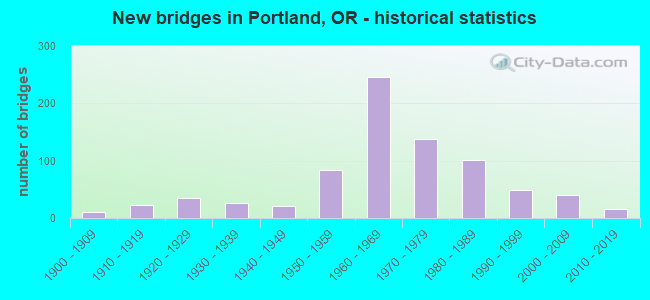
- New bridges - historical statistics
- 111900-1909
- 221910-1919
- 351920-1929
- 261930-1939
- 211940-1949
- 831950-1959
- 2461960-1969
- 1381970-1979
- 1011980-1989
- 481990-1999
- 402000-2009
- 152010-2019
- 12020-2022
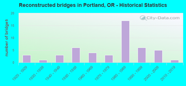
- Reconstructed bridges - Historical Statistics
- 31920-1929
- 11930-1939
- 31940-1949
- 61950-1959
- 41960-1969
- 31970-1979
- 171980-1989
- 61990-1999
- 52000-2009
- 12010-2019
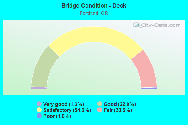
- Bridge Condition - Deck
- 1.3%Very good
- 22.9%Good
- 54.3%Satisfactory
- 20.6%Fair
- 1.0%Poor
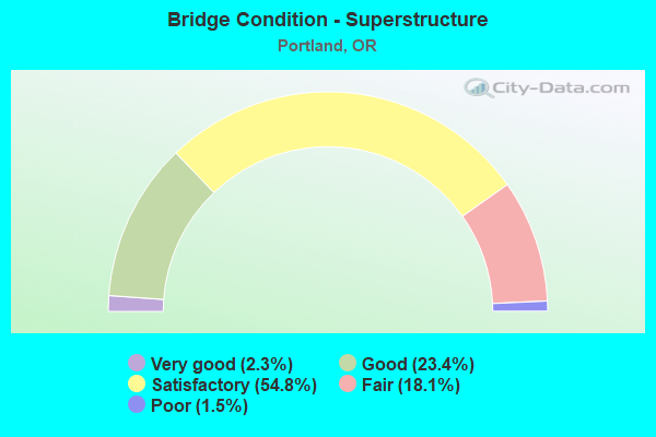
- Bridge Condition - Superstructure
- 2.3%Very good
- 23.4%Good
- 54.8%Satisfactory
- 18.1%Fair
- 1.5%Poor
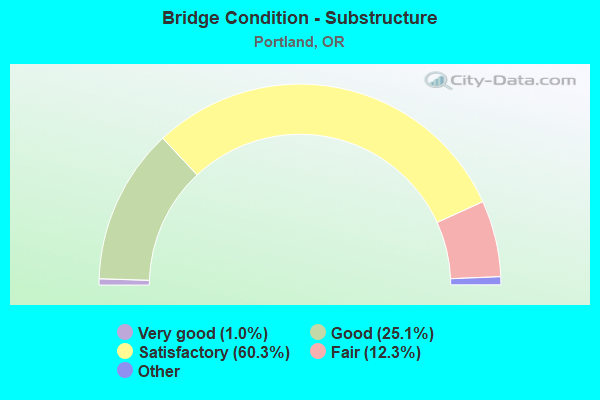
- Bridge Condition - Substructure
- 1.0%Very good
- 25.1%Good
- 60.3%Satisfactory
- 12.3%Fair
- 1.3%Poor
- 0.5%Serious
- 0.3%Critical
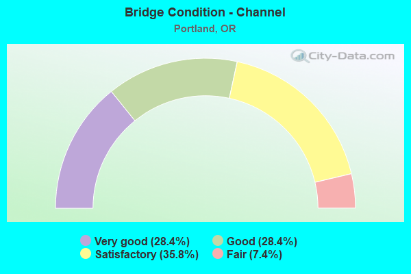
- Bridge Condition - Channel
- 28.4%Very good
- 28.4%Good
- 35.8%Satisfactory
- 7.4%Fair
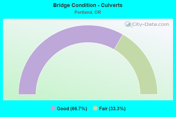
- Bridge Condition - Culverts
- 66.7%Good
- 33.3%Fair
Find on map >> Show street view
Structure Number: 511, Location: WILLAMETTE RIVER MP 12.4 (Lat: 45.523036, Lng: -122.667556), Route carried "on" structure: Business City street 9326, Year Built: 1926, Status: Posted for load, Structure Length: 26.09m (85.60ft), Average Daily Traffic: 58,125 (year 2020), Truck Traffic: 10%, Average Future Daily Traffic: 87,161 (year 2025), Design Load: Railroad, Features Intersected: WILLAMETTE RIVER, Facility Carried by Structure: BURNSIDE BRIDGE
Minimum Vertical Clearance: 30+ m (98+ ft), Kilometerpoint: 0.000, Lanes on structure: 5, Owner: County Highway Agency, Approaching Roadway Width: 20.7m (67.9ft), Navigation Control: Yes ( Vertical Clearance: 19.5m (64.0ft), Horizontal Clearance: 60.0m (196.9ft)), Material/Design: Steel, Design/Construction: Movable - Bascule, Number Of Spans In Main Unit: 1, Number Of Approach Spans: 2, Length of Maximum Span: 81.1m (266.1ft), Curb or Sidewalk Widths: Left: 2.4m (7.9ft), Right: 2.4m (7.9ft), Curb-To-Curb Width: 20.7m (67.9ft), Out-to-Out Width: 26.2m (86.0ft)
Condition: Deck: Satisfactory, Superstructure: Fair, Substructure: Fair, Channel: Fair, Operating Rating: 18.1 metric tons, Method Used To Determine Operating Rating: Load and Resistance Factor Rating (LRFR) rating reported by rating factor(RF) method using HL-93 loadings, Inventory Rating: 13.9 metric tons, Method Used To Determine Inventory Rating: Load and Resistance Factor Rating (LRFR) rating reported by rating factor(RF) method using HL-93 loadings, Structural Evaluation: High priority of corrective action, Deck Geometry: Somewhat better than minimum adequacy, Waterway Adequacy: Equal to present desirable criteria, Approach Roadway Alignment: Equal to present desirable criteria, Bridge Posting: Required (Relationship of Operating Rating to Maximum Legal Load: 10.0 - 19.9% below), Length Of Structure Improvement: 26.10m (85.63ft), Designated Inspection Frequency: Every 24 months, Critical Feature Inspection Frequency: Every 24 months, Underwater Inspection Frequency: Every 60 months, Inspection Date: April 2021, Critical Feature Inspection Date: April 2021, Underwater Inspection Date: September 2020, Bridge Improvement Cost: $2,741,000, Roadway Improvement Cost: $274,000, Total Project Cost: $4,386,000, Deck Structure Type: Concrete Cast-file-Place, Wearing Surface/Protective System: Wearing Surface: Monolithic Concrete
Find on map >> Show street view
Structure Number: 511A9326, Location: WEST END BURNSIDE BR (Lat: 45.523097, Lng: -122.670281), Route carried "on" structure: City street 9326, Year Built: 1927, Status: Posted for load, Structure Length: 18.84m (61.81ft), Average Daily Traffic: 60,407 (year 2020), Truck Traffic: 10%, Average Future Daily Traffic: 90,674 (year 2025), Design Load: HS 15, Features Intersected: WEST BURNSIDE APPROACH, Facility Carried by Structure: BURNSIDE ST
Minimum Vertical Clearance: 30+ m (98+ ft), Kilometerpoint: 0.000, Lanes on structure: 5, Lanes under structure: 4, Base Highway Network: Yes, Owner: County Highway Agency, Approaching Roadway Width: 20.7m (67.9ft), Material/Design: Concrete, Design/Construction: Girder and Floorbeam System, Number Of Spans In Main Unit: 3, Number Of Approach Spans: 16, Length of Maximum Span: 19.2m (63.0ft), Curb or Sidewalk Widths: Left: 2.4m (7.9ft), Right: 2.4m (7.9ft), Curb-To-Curb Width: 20.7m (67.9ft), Out-to-Out Width: 26.2m (86.0ft)
Condition: Deck: Fair, Superstructure: Fair, Substructure: Fair, Operating Rating: 13.9 metric tons, Method Used To Determine Operating Rating: Load and Resistance Factor Rating (LRFR) rating reported by rating factor(RF) method using HL-93 loadings, Inventory Rating: 11.0 metric tons, Method Used To Determine Inventory Rating: Load and Resistance Factor Rating (LRFR) rating reported by rating factor(RF) method using HL-93 loadings, Structural Evaluation: High priority of corrective action, Deck Geometry: Somewhat better than minimum adequacy, Underclear: High priority of corrective action, Approach Roadway Alignment: Equal to present desirable criteria, Bridge Posting: Required (Relationship of Operating Rating to Maximum Legal Load: 30.0 - 39.9% below), Length Of Structure Improvement: 18.80m (61.68ft), Designated Inspection Frequency: Every 24 months, Inspection Date: June 2021, Bridge Improvement Cost: $5,531,000, Roadway Improvement Cost: $553,000, Total Project Cost: $8,850,000, Deck Structure Type: Concrete Cast-file-Place, Wearing Surface/Protective System: Wearing Surface: Integral Concrete
Find on map >> Show street view
Structure Number: 511B9326, Location: EAST END BURNSIDE BR (Lat: 45.522981, Lng: -122.665211), Route carried "on" structure: City street 9326, Year Built: 1927, Status: Posted for load, Structure Length: 26.18m (85.89ft), Average Daily Traffic: 58,691 (year 2020), Truck Traffic: 10%, Average Future Daily Traffic: 88,033 (year 2025), Design Load: HS 15, Features Intersected: EAST BURNSIDE APPROACH, Facility Carried by Structure: BURNSIDE ST
Minimum Vertical Clearance: 30+ m (98+ ft), Kilometerpoint: 0.000, Lanes on structure: 5, Lanes under structure: 11, Owner: County Highway Agency, Approaching Roadway Width: 20.7m (67.9ft), Material/Design: Steel continuous, Design/Construction: Girder and Floorbeam System, Number Of Spans In Main Unit: 8, Number Of Approach Spans: 7, Length of Maximum Span: 32.9m (107.9ft), Curb or Sidewalk Widths: Left: 2.7m (8.9ft), Right: 2.7m (8.9ft), Curb-To-Curb Width: 20.7m (67.9ft), Out-to-Out Width: 26.2m (86.0ft)
Condition: Deck: Fair, Superstructure: Fair, Substructure: Fair, Operating Rating: 15.6 metric tons, Method Used To Determine Operating Rating: Load and Resistance Factor Rating (LRFR) rating reported by rating factor(RF) method using HL-93 loadings, Inventory Rating: 12.0 metric tons, Method Used To Determine Inventory Rating: Load and Resistance Factor Rating (LRFR) rating reported by rating factor(RF) method using HL-93 loadings, Structural Evaluation: High priority of corrective action, Deck Geometry: Somewhat better than minimum adequacy, Underclear: High priority of corrective action, Waterway Adequacy: Superior to present desirable criteria, Approach Roadway Alignment: Equal to present desirable criteria, Bridge Posting: Required (Relationship of Operating Rating to Maximum Legal Load: 10.0 - 19.9% below), Length Of Structure Improvement: 25.90m (84.97ft), Designated Inspection Frequency: Every 24 months, Inspection Date: June 2021, Bridge Improvement Cost: $7,599,000, Roadway Improvement Cost: $760,000, Total Project Cost: $12,158,000, Deck Structure Type: Concrete Cast-file-Place, Wearing Surface/Protective System: Wearing Surface: Integral Concrete
Find on map >> Show street view
Structure Number: 1185A003 004, Location: 0.04 MI N RIVERWOOD ROAD (Lat: 45.447706, Lng: -122.657497), Route carried "on" structure: State highway 43, Year Built: 1926, Year Reconstructed: 1971, Status: Open, Structure Length: 19.97m (65.52ft), Average Daily Traffic: 13,903 (year 2020), Truck Traffic: 2%, Average Future Daily Traffic: 19,900 (year 2040), Design Load: H 15, Features Intersected: RIVERSIDE CANYON, Facility Carried by Structure: HWY 3
Minimum Vertical Clearance: 30+ m (98+ ft), Kilometerpoint: 6.437, Lanes on structure: 3, Owner: State Highway Agency, Approaching Roadway Width: 15.6m (51.2ft), Material/Design: Concrete continuous, Design/Construction: Tee Beam, Number Of Spans In Main Unit: 5, Number Of Approach Spans: 11, Length of Maximum Span: 14.6m (47.9ft), Curb-To-Curb Width: 15.6m (51.2ft), Out-to-Out Width: 2.4m (7.9ft)
Condition: Deck: Good, Superstructure: Good, Substructure: Satisfactory, Operating Rating: 29.0 metric tons, Method Used To Determine Operating Rating: Load Factor (LF), Inventory Rating: 17.2 metric tons, Method Used To Determine Inventory Rating: Load Factor (LF), Structural Evaluation: Meets minimum limits, Deck Geometry: Equal to present minimum criteria, Approach Roadway Alignment: Equal to present desirable criteria, Designated Inspection Frequency: Every 24 months, Inspection Date: December 2021, Deck Structure Type: Concrete Precast Panels, Wearing Surface/Protective System: Wearing Surface: Bituminous
Find on map >> Show street view
Structure Number: 1377A001 30838, Location: AT INTERSTATE BRIDGE (Lat: 45.618039, Lng: -122.675275), Route carried "on" structure: Interstate 5, Year Built: 1916, Year Reconstructed: 1958, Status: Open, Structure Length: 107.84m (353.81ft), Average Daily Traffic: 57,550 (year 2020), Truck Traffic: 7%, Average Future Daily Traffic: 90,050 (year 2040), Design Load: H 15, Features Intersected: COLUMBIA RIVER
Minimum Vertical Clearance: 5.18m (16.99ft), Kilometerpoint: 496.290, Lanes on structure: 3, Lanes under structure: 6, Base Highway Network: Yes, Owner: State Highway Agency, Approaching Roadway Width: 12.8m (42.0ft), Navigation Control: Yes ( Vertical Clearance: 4.3m (14.1ft), Horizontal Clearance: 80.2m (263.1ft)), Material/Design: Steel, Design/Construction: Movable - Lift, Number Of Spans In Main Unit: 1, Number Of Approach Spans: 16, Length of Maximum Span: 85.0m (278.9ft), Curb or Sidewalk Widths: Left: 0.0m, Right: 1.6m (5.2ft), Curb-To-Curb Width: 11.6m (38.1ft), Out-to-Out Width: 13.8m (45.3ft)
Condition: Deck: Fair, Superstructure: Fair, Substructure: Fair, Channel: Good, Operating Rating: 24.0 metric tons, Method Used To Determine Operating Rating: Load and Resistance Factor Rating (LRFR) rating reported by rating factor(RF) method using HL-93 loadings, Inventory Rating: 18.5 metric tons, Method Used To Determine Inventory Rating: Load and Resistance Factor Rating (LRFR) rating reported by rating factor(RF) method using HL-93 loadings, Structural Evaluation: Meets minimum limits, Deck Geometry: High priority of replacement, Underclear: High priority of corrective action, Waterway Adequacy: Equal to present desirable criteria, Approach Roadway Alignment: Equal to present desirable criteria, Length Of Structure Improvement: 107.80m (353.67ft), Designated Inspection Frequency: Every 24 months, Critical Feature Inspection Frequency: Every 24 months, Underwater Inspection Frequency: Every 36 months, Inspection Date: May 2020, Critical Feature Inspection Date: May 2020, Underwater Inspection Date: September 2021, Bridge Improvement Cost: $16,622,000, Roadway Improvement Cost: $1,662,000, Total Project Cost: $26,595,000, Deck Structure Type: Concrete Cast-file-Place, Wearing Surface/Protective System: Wearing Surface: Latex Concrete, Deck Protection: Epoxy Coated Reinforcing
Find on map >> Show street view
Structure Number: 1377C01EX00441, Location: 1.6 MI S OF I-5 JCT (Lat: 45.586533, Lng: -122.664161), Route carried "on" structure: State highway 99, Year Built: 1934, Year Reconstructed: 1954, Status: Open, Structure Length: 9.36m (30.71ft), Average Daily Traffic: 16,300 (year 2020), Truck Traffic: 12%, Average Future Daily Traffic: 27,400 (year 2040), Design Load: H 15, Features Intersected: Columbia Slough, Facility Carried by Structure: Hwy 081
Minimum Vertical Clearance: 30+ m (98+ ft), Kilometerpoint: 7.113, Lanes on structure: 4, Base Highway Network: Yes, Owner: State Highway Agency, Approaching Roadway Width: 17.7m (58.1ft), Skew: 20 degrees, Material/Design: Steel, Design/Construction: Girder and Floorbeam System, Number Of Spans In Main Unit: 4, Length of Maximum Span: 23.5m (77.1ft), Curb or Sidewalk Widths: Left: 1.7m (5.6ft), Right: 0.0m, Curb-To-Curb Width: 16.3m (53.5ft), Out-to-Out Width: 19.4m (63.6ft)
Condition: Deck: Fair, Superstructure: Fair, Substructure: Fair, Channel: Satisfactory, Operating Rating: 14.9 metric tons, Method Used To Determine Operating Rating: Load and Resistance Factor Rating (LRFR) rating reported by rating factor(RF) method using HL-93 loadings, Inventory Rating: 11.3 metric tons, Method Used To Determine Inventory Rating: Load and Resistance Factor Rating (LRFR) rating reported by rating factor(RF) method using HL-93 loadings, Structural Evaluation: High priority of corrective action, Deck Geometry: Meets minimum limits, Waterway Adequacy: Better than present minimum criteria, Approach Roadway Alignment: Equal to present desirable criteria, Designated Inspection Frequency: Every 24 months, Critical Feature Inspection Frequency: Every 24 months, Underwater Inspection Frequency: Every 60 months, Inspection Date: January 2021, Critical Feature Inspection Date: January 2021, Underwater Inspection Date: Febuary 2019, Deck Structure Type: Concrete Cast-file-Place, Wearing Surface/Protective System: Wearing Surface: Bituminous
Find on map >> Show street view
Structure Number: 1726 120 00038, Location: 5.5 MI NW PORTLAND CC (Lat: 45.600381, Lng: -122.719511), Route carried "on" structure: State highway 120, Year Built: 1933, Status: Posted for load, Structure Length: 10.30m (33.79ft), Average Daily Traffic: 12,185 (year 2020), Truck Traffic: 12%, Average Future Daily Traffic: 24,500 (year 2040), Design Load: H 15, Features Intersected: Columbia Slough
Minimum Vertical Clearance: 30+ m (98+ ft), Kilometerpoint: 0.612, Lanes on structure: 2, Owner: State Highway Agency, Approaching Roadway Width: 7.3m (24.0ft), Material/Design: Steel, Design/Construction: Stringer/Multi-beam, Number Of Spans In Main Unit: 1, Number Of Approach Spans: 11, Length of Maximum Span: 25.9m (85.0ft), Curb or Sidewalk Widths: Left: 1.1m (3.6ft), Right: 1.1m (3.6ft), Curb-To-Curb Width: 7.3m (24.0ft), Out-to-Out Width: 10.3m (33.8ft)
Condition: Deck: Satisfactory, Superstructure: Satisfactory, Substructure: Fair, Channel: Very good, Operating Rating: 17.8 metric tons, Method Used To Determine Operating Rating: Load and Resistance Factor Rating (LRFR) rating reported by rating factor(RF) method using HL-93 loadings, Inventory Rating: 13.6 metric tons, Method Used To Determine Inventory Rating: Load and Resistance Factor Rating (LRFR) rating reported by rating factor(RF) method using HL-93 loadings, Structural Evaluation: High priority of corrective action, Deck Geometry: High priority of replacement, Waterway Adequacy: Equal to present desirable criteria, Approach Roadway Alignment: Equal to present desirable criteria, Bridge Posting: Required (Relationship of Operating Rating to Maximum Legal Load: > 39.9% below), Length Of Structure Improvement: 10.30m (33.79ft), Designated Inspection Frequency: Every 24 months, Critical Feature Inspection Frequency: Every 24 months, Inspection Date: January 2021, Critical Feature Inspection Date: January 2021, Bridge Improvement Cost: $1,082,000, Roadway Improvement Cost: $108,000, Total Project Cost: $1,732,000, Deck Structure Type: Concrete Cast-file-Place, Wearing Surface/Protective System: Wearing Surface: Bituminous
Find on map >> Show street view
Structure Number: 1740 02W 01319, Location: 6.3 MI W ST JOHNS BR (Lat: 45.651400, Lng: -122.851111), Route carried "on" structure: US 30, Year Built: 1968, Status: Open, Structure Length: 3.96m (12.99ft), Average Daily Traffic: 19,969 (year 2020), Truck Traffic: 10%, Average Future Daily Traffic: 29,300 (year 2040), Design Load: HS 20, Features Intersected: McCarty Creek, Facility Carried by Structure: Hwy 092
Minimum Vertical Clearance: 30+ m (98+ ft), Kilometerpoint: 21.227, Lanes on structure: 5, Base Highway Network: Yes, Owner: State Highway Agency, Approaching Roadway Width: 25.7m (84.3ft), Material/Design: Concrete continuous, Design/Construction: Slab, Number Of Spans In Main Unit: 3, Length of Maximum Span: 15.8m (51.8ft), Curb-To-Curb Width: 25.7m (84.3ft), Out-to-Out Width: 26.6m (87.3ft)
Condition: Deck: Satisfactory, Superstructure: Good, Substructure: Satisfactory, Channel: Good, Operating Rating: 50.8 metric tons, Method Used To Determine Operating Rating: Load Factor (LF), Inventory Rating: 29.9 metric tons, Method Used To Determine Inventory Rating: Load Factor (LF), Structural Evaluation: Equal to present minimum criteria, Deck Geometry: Superior to present desirable criteria, Waterway Adequacy: Equal to present desirable criteria, Approach Roadway Alignment: Equal to present desirable criteria, Designated Inspection Frequency: Every 24 months, Inspection Date: October 2021, Deck Structure Type: Concrete Cast-file-Place, Wearing Surface/Protective System: Wearing Surface: Monolithic Concrete
Find on map >> Show street view
Structure Number: 1983 01W 00325, Location: 2.0 MI N OF SW 26TH AVE (Lat: 45.479733, Lng: -122.680211), Route carried "on" structure: State highway 99, Year Built: 1934, Status: Open, Structure Length: 11.49m (37.70ft), Average Daily Traffic: 13,347 (year 2020), Truck Traffic: 2%, Average Future Daily Traffic: 23,100 (year 2040), Design Load: H 15, Features Intersected: SW NEWBURY ST VIADUCT
Minimum Vertical Clearance: 30+ m (98+ ft), Kilometerpoint: 5.230, Lanes on structure: 4, Base Highway Network: Yes, Owner: State Highway Agency, Approaching Roadway Width: 15.8m (51.8ft), Material/Design: Wood or Timber, Design/Construction: Stringer/Multi-beam, Number Of Spans In Main Unit: 13, Length of Maximum Span: 8.8m (28.9ft), Curb or Sidewalk Widths: Left: 1.1m (3.6ft), Right: 1.1m (3.6ft), Curb-To-Curb Width: 14.6m (47.9ft), Out-to-Out Width: 17.5m (57.4ft)
Condition: Deck: Fair, Superstructure: Satisfactory, Substructure: Satisfactory, Operating Rating: 15.2 metric tons, Method Used To Determine Operating Rating: Load and Resistance Factor Rating (LRFR) rating reported by rating factor(RF) method using HL-93 loadings, Inventory Rating: 11.7 metric tons, Method Used To Determine Inventory Rating: Load and Resistance Factor Rating (LRFR) rating reported by rating factor(RF) method using HL-93 loadings, Structural Evaluation: High priority of corrective action, Deck Geometry: High priority of replacement, Approach Roadway Alignment: Equal to present desirable criteria, Bridge Posting: Required (Relationship of Operating Rating to Maximum Legal Load: 30.0 - 39.9% below), Length Of Structure Improvement: 11.50m (37.73ft), Designated Inspection Frequency: Every 24 months, Inspection Date: September 2021, Bridge Improvement Cost: $1,207,000, Roadway Improvement Cost: $121,000, Total Project Cost: $1,932,000, Deck Structure Type: Concrete Cast-file-Place, Wearing Surface/Protective System: Wearing Surface: Bituminous
Find on map >> Show street view
Structure Number: 1984 01W 0035, Location: 0.3 M S OF HWY 40 (Lat: 45.476131, Lng: -122.679639), Route carried "on" structure: State highway 99, Year Built: 1934, Status: Open, Structure Length: 16.18m (53.08ft), Average Daily Traffic: 16,366 (year 2020), Truck Traffic: 2%, Average Future Daily Traffic: 28,000 (year 2040), Design Load: H 15, Features Intersected: SW VERMONT ST VIADUCT
Minimum Vertical Clearance: 30+ m (98+ ft), Kilometerpoint: 5.633, Lanes on structure: 4, Base Highway Network: Yes, Owner: State Highway Agency, Approaching Roadway Width: 14.6m (47.9ft), Skew: 23 degrees, Material/Design: Wood or Timber, Design/Construction: Stringer/Multi-beam, Number Of Spans In Main Unit: 18, Length of Maximum Span: 11.6m (38.1ft), Curb or Sidewalk Widths: Left: 1.1m (3.6ft), Right: 1.1m (3.6ft), Curb-To-Curb Width: 14.6m (47.9ft), Out-to-Out Width: 17.5m (57.4ft)
Condition: Deck: Fair, Superstructure: Satisfactory, Substructure: Satisfactory, Operating Rating: 28.8 metric tons, Method Used To Determine Operating Rating: Load and Resistance Factor Rating (LRFR) rating reported by rating factor(RF) method using HL-93 loadings, Inventory Rating: 22.4 metric tons, Method Used To Determine Inventory Rating: Load and Resistance Factor Rating (LRFR) rating reported by rating factor(RF) method using HL-93 loadings, Structural Evaluation: Somewhat better than minimum adequacy, Deck Geometry: High priority of replacement, Approach Roadway Alignment: Equal to present desirable criteria, Length Of Structure Improvement: 17.80m (58.40ft), Designated Inspection Frequency: Every 24 months, Inspection Date: September 2021, Bridge Improvement Cost: $1,870,000, Roadway Improvement Cost: $187,000, Total Project Cost: $2,992,000, Deck Structure Type: Concrete Cast-file-Place, Wearing Surface/Protective System: Wearing Surface: Bituminous, Membrane: Other
Find on map >> Show street view
Structure Number: 1994 068 00224, Location: 5.0 MI E OF PORT CENTER (Lat: 45.533900, Lng: -122.578969), Route carried "on" structure: State highway 213, Year Built: 1934, Year Reconstructed: 1954, Status: Posted for load, Structure Length: 3.54m (11.61ft), Average Daily Traffic: 23,696 (year 2020), Truck Traffic: 3%, Average Future Daily Traffic: 33,500 (year 2040), Design Load: H 15, Features Intersected: UPRR and TriMet
Minimum Vertical Clearance: 30+ m (98+ ft), Kilometerpoint: 3.605, Lanes on structure: 4, Base Highway Network: Yes, Owner: State Highway Agency, Approaching Roadway Width: 18.0m (59.1ft), Skew: 22 degrees, Material/Design: Concrete continuous, Design/Construction: Slab, Number Of Spans In Main Unit: 5, Length of Maximum Span: 9.4m (30.8ft), Curb or Sidewalk Widths: Left: 2.7m (8.9ft), Right: 2.4m (7.9ft), Curb-To-Curb Width: 18.1m (59.4ft), Out-to-Out Width: 35.7m (117.1ft)
Condition: Deck: Good, Superstructure: Satisfactory, Substructure: Satisfactory, Operating Rating: 29.2 metric tons, Method Used To Determine Operating Rating: Field evaluation and documented engineering judgment, Inventory Rating: 22.5 metric tons, Method Used To Determine Inventory Rating: Field evaluation and documented engineering judgment, Structural Evaluation: Somewhat better than minimum adequacy, Deck Geometry: Somewhat better than minimum adequacy, Underclear: Somewhat better than minimum adequacy, Approach Roadway Alignment: Equal to present desirable criteria, Bridge Posting: Required (Relationship of Operating Rating to Maximum Legal Load: 10.0 - 19.9% below), Length Of Structure Improvement: 3.50m (11.48ft), Designated Inspection Frequency: Every 24 months, Inspection Date: June 2021, Bridge Improvement Cost: $371,000, Roadway Improvement Cost: $37,000, Total Project Cost: $594,000, Deck Structure Type: Concrete Cast-file-Place, Wearing Surface/Protective System: Wearing Surface: Bituminous, Membrane: Preformed Fabric
Find on map >> Show street view
Structure Number: 2008A01E 00443, Location: 0.2 MI N MILWAUKIE CC (Lat: 45.463861, Lng: -122.638436), Route carried "on" structure: State highway 99, Year Built: 1991, Status: Open, Structure Length: 2.93m (9.61ft), Average Daily Traffic: 43,859 (year 2020), Truck Traffic: 5%, Average Future Daily Traffic: 56,200 (year 2040), Design Load: HS 25 or greater, Features Intersected: Johnson Creek
Minimum Vertical Clearance: 30+ m (98+ ft), Kilometerpoint: 7.129, Lanes on structure: 7, Base Highway Network: Yes, Owner: State Highway Agency, Approaching Roadway Width: 31.1m (102.0ft), Skew: 32 degrees, Material/Design: Prestressed concrete, Design/Construction: Box Beam or Girders - Multiple, Number Of Spans In Main Unit: 1, Length of Maximum Span: 29.3m (96.1ft), Curb or Sidewalk Widths: Left: 2.4m (7.9ft), Right: 2.4m (7.9ft), Curb-To-Curb Width: 31.1m (102.0ft), Out-to-Out Width: 37.1m (121.7ft)
Condition: Deck: Good, Superstructure: Good, Substructure: Good, Channel: Very good, Operating Rating: 35.0 metric tons, Method Used To Determine Operating Rating: Load and Resistance Factor Rating (LRFR) rating reported by rating factor(RF) method using HL-93 loadings, Inventory Rating: 26.9 metric tons, Method Used To Determine Inventory Rating: Load and Resistance Factor Rating (LRFR) rating reported by rating factor(RF) method using HL-93 loadings, Structural Evaluation: Equal to present minimum criteria, Deck Geometry: Better than present minimum criteria, Waterway Adequacy: Equal to present desirable criteria, Approach Roadway Alignment: Equal to present desirable criteria, Designated Inspection Frequency: Every 24 months, Inspection Date: November 2020, Deck Structure Type: Concrete Cast-file-Place, Wearing Surface/Protective System: Wearing Surface: Bituminous, Membrane: Preformed Fabric, Deck Protection: Epoxy Coated Reinforcing
Find on map >> Show street view
Structure Number: 2010 01W 00486, Location: 1.7 MI S OF HWY 40 (Lat: 45.465067, Lng: -122.698792), Route carried "on" structure: State highway 99, Year Built: 1935, Status: Open, Structure Length: 5.55m (18.21ft), Average Daily Traffic: 20,355 (year 2020), Truck Traffic: 2%, Average Future Daily Traffic: 30,100 (year 2040), Design Load: H 15, Features Intersected: SW MULTNOMAH BLVD
Minimum Vertical Clearance: 30+ m (98+ ft), Kilometerpoint: 7.821, Lanes on structure: 4, Lanes under structure: 2, Base Highway Network: Yes, Owner: State Highway Agency, Approaching Roadway Width: 14.6m (47.9ft), Skew: 4 degrees, Material/Design: Concrete continuous, Design/Construction: Tee Beam, Number Of Spans In Main Unit: 3, Length of Maximum Span: 21.3m (69.9ft), Curb or Sidewalk Widths: Left: 1.1m (3.6ft), Right: 1.1m (3.6ft), Curb-To-Curb Width: 14.6m (47.9ft), Out-to-Out Width: 17.5m (57.4ft)
Condition: Deck: Satisfactory, Superstructure: Satisfactory, Substructure: Satisfactory, Operating Rating: 26.9 metric tons, Method Used To Determine Operating Rating: Load and Resistance Factor Rating (LRFR) rating reported by rating factor(RF) method using HL-93 loadings, Inventory Rating: 20.7 metric tons, Method Used To Determine Inventory Rating: Load and Resistance Factor Rating (LRFR) rating reported by rating factor(RF) method using HL-93 loadings, Structural Evaluation: Somewhat better than minimum adequacy, Deck Geometry: High priority of replacement, Underclear: Meets minimum limits, Approach Roadway Alignment: Equal to present desirable criteria, Length Of Structure Improvement: 5.50m (18.04ft), Designated Inspection Frequency: Every 24 months, Inspection Date: Febuary 2020, Bridge Improvement Cost: $583,000, Roadway Improvement Cost: $58,000, Total Project Cost: $932,000, Deck Structure Type: Concrete Cast-file-Place, Wearing Surface/Protective System: Wearing Surface: Bituminous
Find on map >> Show street view
Structure Number: 2014A02W 01123, Location: 4.3 MI W ST JOHNS BR (Lat: 45.630600, Lng: -122.823700), Route carried "on" structure: US 30, Year Built: 1968, Status: Open, Structure Length: 0.72m (2.36ft), Average Daily Traffic: 19,952 (year 2020), Truck Traffic: 10%, Average Future Daily Traffic: 29,300 (year 2040), Design Load: HS 20, Features Intersected: PNWR, Facility Carried by Structure: Hwy 092
Minimum Vertical Clearance: 30+ m (98+ ft), Kilometerpoint: 18.073, Lanes on structure: 4, Base Highway Network: Yes, Owner: State Highway Agency, Approaching Roadway Width: 21.9m (71.9ft), Skew: 2 degrees, Material/Design: Concrete, Design/Construction: Frame, Number Of Spans In Main Unit: 1, Length of Maximum Span: 6.1m (20.0ft), Curb-To-Curb Width: 21.9m (71.9ft), Out-to-Out Width: 138.4m (454.1ft)
Condition: Deck: Satisfactory, Superstructure: Satisfactory, Substructure: Satisfactory, Operating Rating: 19.4 metric tons, Method Used To Determine Operating Rating: Load and Resistance Factor Rating (LRFR) rating reported by rating factor(RF) method using HL-93 loadings, Inventory Rating: 14.9 metric tons, Method Used To Determine Inventory Rating: Load and Resistance Factor Rating (LRFR) rating reported by rating factor(RF) method using HL-93 loadings, Structural Evaluation: High priority of corrective action, Deck Geometry: Superior to present desirable criteria, Underclear: Meets minimum limits, Approach Roadway Alignment: Equal to present desirable criteria, Designated Inspection Frequency: Every 24 months, Inspection Date: October 2021, Deck Structure Type: Concrete Cast-file-Place, Wearing Surface/Protective System: Wearing Surface: Monolithic Concrete
Find on map >> Show street view
Structure Number: 2097 01E 00159, Location: 1.5 MI SE PORTLAND CC (Lat: 45.500000, Lng: -122.660300), Route carried "on" structure: State highway 99, Year Built: 1937, Year Reconstructed: 1955, Status: Open, Structure Length: 31.61m (103.71ft), Average Daily Traffic: 64,338 (year 2020), Truck Traffic: 5%, Average Future Daily Traffic: 81,500 (year 2040), Design Load: H 15, Features Intersected: Grand Ave, Facility Carried by Structure: Hwy 081
Minimum Vertical Clearance: 30+ m (98+ ft), Kilometerpoint: 2.559, Lanes on structure: 3, Base Highway Network: Yes, Owner: State Highway Agency, Approaching Roadway Width: 30.3m (99.4ft), Material/Design: Concrete continuous, Design/Construction: Tee Beam, Number Of Spans In Main Unit: 27, Length of Maximum Span: 13.7m (44.9ft), Curb or Sidewalk Widths: Left: 0.0m, Right: 1.5m (4.9ft), Curb-To-Curb Width: 16.6m (54.5ft), Out-to-Out Width: 7.0m (23.0ft)
Condition: Deck: Satisfactory, Superstructure: Satisfactory, Substructure: Satisfactory, Operating Rating: 20.1 metric tons, Method Used To Determine Operating Rating: Load and Resistance Factor Rating (LRFR) rating reported by rating factor(RF) method using HL-93 loadings, Inventory Rating: 15.6 metric tons, Method Used To Determine Inventory Rating: Load and Resistance Factor Rating (LRFR) rating reported by rating factor(RF) method using HL-93 loadings, Structural Evaluation: High priority of corrective action, Deck Geometry: Equal to present desirable criteria, Approach Roadway Alignment: Equal to present desirable criteria, Designated Inspection Frequency: Every 24 months, Inspection Date: January 2021, Deck Structure Type: Concrete Cast-file-Place, Wearing Surface/Protective System: Wearing Surface: Bituminous
Find on map >> Show street view
Structure Number: 2163A002 00673, Location: 3.0 MI E OF NE 60TH AVE (Lat: 45.545617, Lng: -122.557842), Route carried "on" structure: City street , Year Built: 1936, Year Reconstructed: 1962, Status: Open, Structure Length: 19.78m (64.90ft), Average Daily Traffic: 45,910 (year 2020), Truck Traffic: 8%, Average Future Daily Traffic: 55,600 (year 2040), Design Load: H 15, Features Intersected: Hwy 002, Facility Carried by Structure: 102nd Ave
Minimum Vertical Clearance: 30+ m (98+ ft), Kilometerpoint: 10.831, Lanes on structure: 4, Lanes under structure: 5, Base Highway Network: Yes, Owner: State Highway Agency, Approaching Roadway Width: 17.1m (56.1ft), Skew: 30 degrees, Material/Design: Steel, Design/Construction: Stringer/Multi-beam, Number Of Spans In Main Unit: 1, Number Of Approach Spans: 11, Length of Maximum Span: 37.2m (122.0ft), Curb or Sidewalk Widths: Left: 1.2m (3.9ft), Right: 0.0m, Curb-To-Curb Width: 17.1m (56.1ft), Out-to-Out Width: 20.1m (65.9ft)
Condition: Deck: Fair, Superstructure: Satisfactory, Substructure: Satisfactory, Operating Rating: 19.1 metric tons, Method Used To Determine Operating Rating: Load and Resistance Factor Rating (LRFR) rating reported by rating factor(RF) method using HL-93 loadings, Inventory Rating: 14.6 metric tons, Method Used To Determine Inventory Rating: Load and Resistance Factor Rating (LRFR) rating reported by rating factor(RF) method using HL-93 loadings, Structural Evaluation: High priority of corrective action, Deck Geometry: Somewhat better than minimum adequacy, Underclear: High priority of corrective action, Approach Roadway Alignment: Equal to present desirable criteria, Length Of Structure Improvement: 19.80m (64.96ft), Designated Inspection Frequency: Every 24 months, Critical Feature Inspection Frequency: Every 24 months, Inspection Date: April 2021, Critical Feature Inspection Date: April 2021, Bridge Improvement Cost: $4,463,000, Roadway Improvement Cost: $446,000, Total Project Cost: $7,141,000, Deck Structure Type: Concrete Cast-file-Place, Wearing Surface/Protective System: Wearing Surface: Monolithic Concrete
Find on map >> Show street view
Structure Number: 2237A01E 00262, Location: 3.0 MI SE PORTLAND CC (Lat: 45.487308, Lng: -122.650336), Route carried "on" structure: Business City street 99, Year Built: 1968, Status: Open, Structure Length: 5.64m (18.50ft), Average Daily Traffic: 49,500 (year 2018), Truck Traffic: 4%, Average Future Daily Traffic: 54,300 (year 2038), Design Load: HS 20, Features Intersected: Hwy 081, Facility Carried by Structure: Milwaukie Ave
Minimum Vertical Clearance: 30+ m (98+ ft), Kilometerpoint: 0.000, Lanes on structure: 2, Lanes under structure: 6, Base Highway Network: Yes, Owner: State Highway Agency, Approaching Roadway Width: 13.4m (44.0ft), Skew: 5 degrees, Material/Design: Steel, Design/Construction: Stringer/Multi-beam, Number Of Spans In Main Unit: 1, Number Of Approach Spans: 1, Length of Maximum Span: 56.4m (185.0ft), Curb or Sidewalk Widths: Left: 2.1m (6.9ft), Right: 2.1m (6.9ft), Curb-To-Curb Width: 13.4m (44.0ft), Out-to-Out Width: 18.3m (60.0ft)
Condition: Deck: Satisfactory, Superstructure: Satisfactory, Substructure: Satisfactory, Operating Rating: 27.9 metric tons, Method Used To Determine Operating Rating: Load and Resistance Factor Rating (LRFR) rating reported by rating factor(RF) method using HL-93 loadings, Inventory Rating: 21.4 metric tons, Method Used To Determine Inventory Rating: Load and Resistance Factor Rating (LRFR) rating reported by rating factor(RF) method using HL-93 loadings, Structural Evaluation: Somewhat better than minimum adequacy, Deck Geometry: Equal to present minimum criteria, Underclear: Meets minimum limits, Approach Roadway Alignment: Equal to present desirable criteria, Designated Inspection Frequency: Every 24 months, Inspection Date: January 2021, Deck Structure Type: Concrete Cast-file-Place, Wearing Surface/Protective System: Wearing Surface: Monolithic Concrete
Find on map >> Show street view
Structure Number: 2350A01EX0002, Location: 0.1 MI E PORTLAND CC (Lat: 45.525728, Lng: -122.661717), Route carried "on" structure: State highway 99, Year Built: 1908, Year Reconstructed: 1960, Status: Open, Structure Length: 14.14m (46.39ft), Average Daily Traffic: 35,800 (year 2018), Truck Traffic: 4%, Average Future Daily Traffic: 39,900 (year 2038), Design Load: H 15, Features Intersected: Hwy 2 & UPRR, Facility Carried by Structure: NE MLK BLVD
Minimum Vertical Clearance: 30+ m (98+ ft), Kilometerpoint: 0.000, Lanes on structure: 4, Lanes under structure: 6, Base Highway Network: Yes, Owner: State Highway Agency, Approaching Roadway Width: 17.1m (56.1ft), Material/Design: Steel continuous, Design/Construction: Girder and Floorbeam System, Number Of Spans In Main Unit: 11, Number Of Approach Spans: 1, Length of Maximum Span: 27.4m (89.9ft), Curb or Sidewalk Widths: Left: 3.5m (11.5ft), Right: 3.5m (11.5ft), Curb-To-Curb Width: 17.1m (56.1ft), Out-to-Out Width: 24.4m (80.1ft)
Condition: Deck: Satisfactory, Superstructure: Fair, Substructure: Fair, Operating Rating: 29.9 metric tons, Method Used To Determine Operating Rating: Load Factor (LF), Inventory Rating: 18.1 metric tons, Method Used To Determine Inventory Rating: Load Factor (LF), Structural Evaluation: Meets minimum limits, Deck Geometry: Somewhat better than minimum adequacy, Underclear: High priority of corrective action, Approach Roadway Alignment: Equal to present desirable criteria, Length Of Structure Improvement: 14.10m (46.26ft), Designated Inspection Frequency: Every 24 months, Critical Feature Inspection Frequency: Every 24 months, Inspection Date: April 2021, Critical Feature Inspection Date: April 2021, Bridge Improvement Cost: $3,861,000, Roadway Improvement Cost: $386,000, Total Project Cost: $6,177,000, Deck Structure Type: Concrete Cast-file-Place, Wearing Surface/Protective System: Wearing Surface: Bituminous
Find on map >> Show street view
Structure Number: 2484 000 00014, Location: 1 BLOCK N OF DEKUM ST (Lat: 45.572861, Lng: -122.630669), Route carried "on" structure: City street 9823, Year Built: 1929, Year Reconstructed: 1938, Status: Open, Structure Length: 8.38m (27.49ft), Average Daily Traffic: 10,762 (year 2020), Truck Traffic: 20%, Average Future Daily Traffic: 14,257 (year 2025), Design Load: HS 20, Features Intersected: B-9 OVER UPRR, Facility Carried by Structure: NE 33RD AVE
Minimum Vertical Clearance: 30+ m (98+ ft), Kilometerpoint: 0.225, Lanes on structure: 2, Owner: City or Municipal Highway Agency, Approaching Roadway Width: 13.4m (44.0ft), Skew: 31 degrees, Material/Design: Concrete continuous, Design/Construction: Stringer/Multi-beam, Number Of Spans In Main Unit: 2, Number Of Approach Spans: 12, Length of Maximum Span: 19.2m (63.0ft), Curb or Sidewalk Widths: Left: 1.9m (6.2ft), Right: 0.5m (1.6ft), Curb-To-Curb Width: 10.1m (33.1ft), Out-to-Out Width: 15.1m (49.5ft)
Condition: Deck: Satisfactory, Superstructure: Satisfactory, Substructure: Critical, Operating Rating: 5.8 metric tons, Method Used To Determine Operating Rating: Load and Resistance Factor Rating (LRFR) rating reported by rating factor(RF) method using HL-93 loadings, Inventory Rating: 4.5 metric tons, Method Used To Determine Inventory Rating: Load and Resistance Factor Rating (LRFR) rating reported by rating factor(RF) method using HL-93 loadings, Structural Evaluation: High priority of replacement, Deck Geometry: Meets minimum limits, Underclear: High priority of corrective action, Approach Roadway Alignment: Meets minimum limits, Bridge Posting: Required (Relationship of Operating Rating to Maximum Legal Load: > 39.9% below), Length Of Structure Improvement: 8.40m (27.56ft), Designated Inspection Frequency: Every 24 months, Inspection Date: July 2020, Bridge Improvement Cost: $881,000, Roadway Improvement Cost: $88,000, Total Project Cost: $1,409,000, Deck Structure Type: Concrete Cast-file-Place, Wearing Surface/Protective System: Wearing Surface: Integral Concrete
Find on map >> Show street view
Structure Number: 2484A000 00014, Location: 1 BLOCK N OF DEKUM ST (Lat: 45.573419, Lng: -122.629803), Route carried "on" structure: Ramp City street 9823, Year Built: 1967, Status: Open, Structure Length: 16.15m (52.99ft), Average Daily Traffic: 5,161 (year 2020), Truck Traffic: 20%, Average Future Daily Traffic: 5,692 (year 2025), Design Load: HS 20, Features Intersected: B-9A X NE COLUMBIA BLVD, Facility Carried by Structure: NE 33RD AVE RAMP
Minimum Vertical Clearance: 30+ m (98+ ft), Kilometerpoint: 0.225, Lanes on structure: 1, Lanes under structure: 6, Owner: City or Municipal Highway Agency, Approaching Roadway Width: 13.4m (44.0ft), Material/Design: Steel, Design/Construction: Girder and Floorbeam System, Number Of Spans In Main Unit: 2, Number Of Approach Spans: 12, Length of Maximum Span: 17.1m (56.1ft), Curb or Sidewalk Widths: Left: 0.2m (0.7ft), Right: 0.5m (1.6ft), Curb-To-Curb Width: 5.5m (18.0ft), Out-to-Out Width: 6.7m (22.0ft)
Condition: Deck: Fair, Superstructure: Satisfactory, Substructure: Satisfactory, Operating Rating: 27.2 metric tons, Method Used To Determine Operating Rating: Load and Resistance Factor Rating (LRFR) rating reported by rating factor(RF) method using HL-93 loadings, Inventory Rating: 21.1 metric tons, Method Used To Determine Inventory Rating: Load and Resistance Factor Rating (LRFR) rating reported by rating factor(RF) method using HL-93 loadings, Structural Evaluation: Somewhat better than minimum adequacy, Deck Geometry: Meets minimum limits, Underclear: High priority of corrective action, Approach Roadway Alignment: Meets minimum limits, Length Of Structure Improvement: 16.20m (53.15ft), Designated Inspection Frequency: Every 24 months, Critical Feature Inspection Frequency: Every 24 months, Inspection Date: July 2020, Critical Feature Inspection Date: August 2020, Bridge Improvement Cost: $1,210,000, Roadway Improvement Cost: $121,000, Total Project Cost: $1,936,000, Deck Structure Type: Concrete Cast-file-Place, Wearing Surface/Protective System: Wearing Surface: Monolithic Concrete
Find on map >> Show street view
Structure Number: 2485 000 00219, Location: NE PORTLAND (Lat: 45.570319, Lng: -122.618911), Route carried "on" structure: County highway , Year Built: 1938, Status: Open, Structure Length: 9.11m (29.89ft), Average Daily Traffic: 8,234 (year 2020), Truck Traffic: 10%, Average Future Daily Traffic: 9,081 (year 2025), Design Load: H 15, Features Intersected: B-75 X LOMBARD AND UPRR, Facility Carried by Structure: NE 42ND AVE
Minimum Vertical Clearance: 30+ m (98+ ft), Kilometerpoint: 3.524, Lanes on structure: 2, Lanes under structure: 4, Owner: City or Municipal Highway Agency, Approaching Roadway Width: 6.7m (22.0ft), Skew: 2 degrees, Material/Design: Steel, Design/Construction: Stringer/Multi-beam, Number Of Spans In Main Unit: 5, Length of Maximum Span: 21.9m (71.9ft), Curb or Sidewalk Widths: Left: 1.5m (4.9ft), Right: 1.5m (4.9ft), Curb-To-Curb Width: 7.9m (25.9ft), Out-to-Out Width: 11.5m (37.7ft)
Condition: Deck: Fair, Superstructure: Fair, Substructure: Satisfactory, Operating Rating: 21.4 metric tons, Method Used To Determine Operating Rating: Load and Resistance Factor Rating (LRFR) rating reported by rating factor(RF) method using HL-93 loadings, Inventory Rating: 16.5 metric tons, Method Used To Determine Inventory Rating: Load and Resistance Factor Rating (LRFR) rating reported by rating factor(RF) method using HL-93 loadings, Structural Evaluation: Meets minimum limits, Deck Geometry: High priority of corrective action, Underclear: High priority of corrective action, Approach Roadway Alignment: Equal to present minimum criteria, Length Of Structure Improvement: 9.10m (29.86ft), Designated Inspection Frequency: Every 24 months, Inspection Date: July 2020, Bridge Improvement Cost: $1,169,000, Roadway Improvement Cost: $117,000, Total Project Cost: $1,871,000, Deck Structure Type: Concrete Cast-file-Place, Wearing Surface/Protective System: Wearing Surface: Epoxy Overlay
Find on map >> Show street view
Structure Number: 2529 061 00332, Location: FREMONT BRIDGE (Lat: 45.538139, Lng: -122.683100), Route carried "on" structure: Interstate 405, Year Built: 1973, Status: Open, Structure Length: 65.65m (215.39ft), Average Daily Traffic: 101,643 (year 2020), Truck Traffic: 10%, Average Future Daily Traffic: 150,900 (year 2040), Design Load: HS 20, Features Intersected: Willamette River, Facility Carried by Structure: HWY 061
Minimum Vertical Clearance: 5.92m (19.42ft), Kilometerpoint: 5.343, Lanes on structure: 8, Lanes under structure: 4, Base Highway Network: Yes, Owner: State Highway Agency, Approaching Roadway Width: 41.5m (136.2ft), Navigation Control: Yes ( Vertical Clearance: 53.3m (174.9ft), Horizontal Clearance: 298.7m (980.0ft)), Material/Design: Steel continuous, Design/Construction: Arch - Thru, Number Of Spans In Main Unit: 3, Length of Maximum Span: 382.5m (1,254.9ft), Curb-To-Curb Width: 41.5m (136.2ft), Out-to-Out Width: 45.7m (149.9ft)
Condition: Deck: Satisfactory, Superstructure: Satisfactory, Substructure: Satisfactory, Channel: Very good, Operating Rating: 15.2 metric tons, Method Used To Determine Operating Rating: Load and Resistance Factor Rating (LRFR) rating reported by rating factor(RF) method using HL-93 loadings, Inventory Rating: 11.7 metric tons, Method Used To Determine Inventory Rating: Load and Resistance Factor Rating (LRFR) rating reported by rating factor(RF) method using HL-93 loadings, Structural Evaluation: High priority of corrective action, Deck Geometry: Equal to present minimum criteria, Underclear: Meets minimum limits, Waterway Adequacy: Equal to present desirable criteria, Approach Roadway Alignment: Equal to present desirable criteria, Length Of Structure Improvement: 65.70m (215.55ft), Designated Inspection Frequency: Every 24 months, Critical Feature Inspection Frequency: Every 24 months, Inspection Date: June 2021, Critical Feature Inspection Date: June 2021, Bridge Improvement Cost: $32,056,000, Roadway Improvement Cost: $3,206,000, Total Project Cost: $51,289,000, Deck Structure Type: Concrete Cast-file-Place
Find on map >> Show street view
Structure Number: 2641A02W 01077, Location: 3.8 MI W OF ST JOHNS BR (Lat: 45.626675, Lng: -122.818611), Route carried "on" structure: US 30, Year Built: 1949, Year Reconstructed: 1969, Status: Open, Structure Length: 13.02m (42.72ft), Average Daily Traffic: 9,976 (year 2020), Truck Traffic: 10%, Average Future Daily Traffic: 14,650 (year 2040), Design Load: HS 20, Features Intersected: Partial Viaduct, Facility Carried by Structure: Hwy 092
Minimum Vertical Clearance: 30+ m (98+ ft), Kilometerpoint: 17.333, Lanes on structure: 1, Base Highway Network: Yes, Owner: State Highway Agency, Approaching Roadway Width: 21.3m (69.9ft), Material/Design: Concrete continuous, Design/Construction: Tee Beam, Number Of Spans In Main Unit: 1, Length of Maximum Span: 9.1m (29.9ft), Curb-To-Curb Width: 21.3m (69.9ft), Out-to-Out Width: 2.4m (7.9ft)
Condition: Deck: Good, Superstructure: Good, Substructure: Good, Operating Rating: 20.7 metric tons, Method Used To Determine Operating Rating: Load and Resistance Factor Rating (LRFR) rating reported by rating factor(RF) method using HL-93 loadings, Inventory Rating: 16.2 metric tons, Method Used To Determine Inventory Rating: Load and Resistance Factor Rating (LRFR) rating reported by rating factor(RF) method using HL-93 loadings, Structural Evaluation: Meets minimum limits, Deck Geometry: Superior to present desirable criteria, Approach Roadway Alignment: Equal to present desirable criteria, Designated Inspection Frequency: Every 24 months, Inspection Date: October 2021, Deck Structure Type: Concrete Cast-file-Place, Wearing Surface/Protective System: Wearing Surface: Bituminous
Find on map >> Show street view
Structure Number: 2733B01WX00052, Location: AT WEST END OF STEEL BR (Lat: 45.525772, Lng: -122.670714), Route carried "on" structure: Ramp State highway 99, Year Built: 1950, Year Reconstructed: 1985, Status: Open, Structure Length: 7.07m (23.20ft), Average Daily Traffic: 3,920 (year 2020), Truck Traffic: 6%, Average Future Daily Traffic: 8,239 (year 2030), Design Load: H 15, Features Intersected: FRONT AVENUE, Facility Carried by Structure: HWY 1W/EVERETT RMP
Minimum Vertical Clearance: 30+ m (98+ ft), Kilometerpoint: 0.390, Lanes on structure: 1, Lanes under structure: 4, Owner: State Highway Agency, Approaching Roadway Width: 7.9m (25.9ft), Skew: 9 degrees, Material/Design: Concrete continuous, Design/Construction: Tee Beam, Number Of Spans In Main Unit: 4, Length of Maximum Span: 18.4m (60.4ft), Curb-To-Curb Width: 7.9m (25.9ft), Out-to-Out Width: 9.0m (29.5ft)
Condition: Deck: Satisfactory, Superstructure: Satisfactory, Substructure: Satisfactory, Operating Rating: 16.2 metric tons, Method Used To Determine Operating Rating: Load and Resistance Factor Rating (LRFR) rating reported by rating factor(RF) method using HL-93 loadings, Inventory Rating: 12.6 metric tons, Method Used To Determine Inventory Rating: Load and Resistance Factor Rating (LRFR) rating reported by rating factor(RF) method using HL-93 loadings, Structural Evaluation: Meets minimum limits, Deck Geometry: Equal to present desirable criteria, Underclear: High priority of corrective action, Approach Roadway Alignment: Equal to present minimum criteria, Length Of Structure Improvement: 7.20m (23.62ft), Designated Inspection Frequency: Every 24 months, Inspection Date: Febuary 2020, Bridge Improvement Cost: $734,000, Roadway Improvement Cost: $73,000, Total Project Cost: $1,174,000, Deck Structure Type: Concrete Cast-file-Place, Wearing Surface/Protective System: Wearing Surface: Latex Concrete
Find on map >> Show street view
Structure Number: 2733C01WX00014, Location: AT W END OF STEEL BRIDGE (Lat: 45.526192, Lng: -122.670675), Route carried "on" structure: State highway 99, Year Built: 1950, Status: Open, Structure Length: 17.12m (56.17ft), Average Daily Traffic: 5,181 (year 2020), Truck Traffic: 6%, Average Future Daily Traffic: 8,300 (year 2040), Design Load: H 15, Features Intersected: FRONT AVE TO STEEL BR, Facility Carried by Structure: HWY 1W NB
Minimum Vertical Clearance: 30+ m (98+ ft), Kilometerpoint: 0.467, Lanes on structure: 1, Owner: State Highway Agency, Approaching Roadway Width: 7.9m (25.9ft), Material/Design: Concrete continuous, Design/Construction: Tee Beam, Number Of Spans In Main Unit: 10, Number Of Approach Spans: 1, Length of Maximum Span: 27.8m (91.2ft), Curb or Sidewalk Widths: Left: 1.5m (4.9ft), Right: 0.0m, Curb-To-Curb Width: 7.9m (25.9ft), Out-to-Out Width: 10.3m (33.8ft)
Condition: Deck: Satisfactory, Superstructure: Satisfactory, Substructure: Fair, Operating Rating: 24.5 metric tons, Method Used To Determine Operating Rating: Load Factor (LF), Inventory Rating: 14.5 metric tons, Method Used To Determine Inventory Rating: Load Factor (LF), Structural Evaluation: High priority of corrective action, Deck Geometry: High priority of corrective action, Approach Roadway Alignment: Equal to present desirable criteria, Length Of Structure Improvement: 16.70m (54.79ft), Designated Inspection Frequency: Every 24 months, Critical Feature Inspection Frequency: Every 24 months, Inspection Date: Febuary 2020, Critical Feature Inspection Date: November 2020, Bridge Improvement Cost: $1,755,000, Roadway Improvement Cost: $175,000, Total Project Cost: $2,808,000, Deck Structure Type: Concrete Cast-file-Place, Wearing Surface/Protective System: Wearing Surface: Latex Concrete
Find on map >> Show street view
Structure Number: 2757, Location: WILLAMETTE RIVER MP 13.2 (Lat: 45.513211, Lng: -122.670950), Route carried "on" structure: City street 9366, Year Built: 1910, Year Reconstructed: 1997, Status: Open, Structure Length: 42.15m (138.29ft), Average Daily Traffic: 32,243 (year 2020), Truck Traffic: 10%, Average Future Daily Traffic: 35,560 (year 2025), Design Load: Railroad, Features Intersected: WILLAMETTE RIVER, Facility Carried by Structure: HAWTHORNE AVE
Minimum Vertical Clearance: 5.18m (16.99ft), Kilometerpoint: 0.000, Lanes on structure: 4, Owner: County Highway Agency, Approaching Roadway Width: 13.4m (44.0ft), Skew: 30 degrees, Navigation Control: Yes ( Vertical Clearance: 33.5m (109.9ft), Horizontal Clearance: 73.2m (240.2ft)), Material/Design: Steel, Design/Construction: Movable - Lift, Number Of Spans In Main Unit: 1, Number Of Approach Spans: 5, Length of Maximum Span: 76.5m (251.0ft), Curb or Sidewalk Widths: Left: 3.2m (10.5ft), Right: 3.2m (10.5ft), Curb-To-Curb Width: 13.3m (43.6ft), Out-to-Out Width: 22.3m (73.2ft)
Condition: Deck: Satisfactory, Superstructure: Fair, Substructure: Fair, Channel: Good, Operating Rating: 25.9 metric tons, Method Used To Determine Operating Rating: Load and Resistance Factor Rating (LRFR) rating reported by rating factor(RF) method using HL-93 loadings, Inventory Rating: 19.8 metric tons, Method Used To Determine Inventory Rating: Load and Resistance Factor Rating (LRFR) rating reported by rating factor(RF) method using HL-93 loadings, Structural Evaluation: Somewhat better than minimum adequacy, Deck Geometry: High priority of replacement, Waterway Adequacy: Superior to present desirable criteria, Approach Roadway Alignment: Equal to present desirable criteria, Length Of Structure Improvement: 42.20m (138.45ft), Designated Inspection Frequency: Every 24 months, Critical Feature Inspection Frequency: Every 24 months, Underwater Inspection Frequency: Every 60 months, Inspection Date: May 2021, Critical Feature Inspection Date: May 2021, Underwater Inspection Date: September 2020, Bridge Improvement Cost: $4,429,000, Roadway Improvement Cost: $443,000, Total Project Cost: $7,086,000, Deck Structure Type: Open Grating, Wearing Surface/Protective System: Wearing Surface: Other
Find on map >> Show street view
Structure Number: 2757A, Location: BETWEEN SE WATER & GRAND (Lat: 45.512014, Lng: -122.662275), Route carried "on" structure: City street 9366, Year Built: 1957, Year Reconstructed: 2000, Status: Open, Structure Length: 37.80m (124.02ft), Average Daily Traffic: 12,852 (year 2020), Truck Traffic: 10%, Average Future Daily Traffic: 19,363 (year 2025), Design Load: HS 20, Features Intersected: OR 99E (01E), Facility Carried by Structure: RAMP TO HAWTHORNE
Minimum Vertical Clearance: 30+ m (98+ ft), Kilometerpoint: 0.000, Lanes on structure: 2, Lanes under structure: 9, Owner: County Highway Agency, Approaching Roadway Width: 12.8m (42.0ft), Skew: 10 degrees, Material/Design: Steel continuous, Design/Construction: Stringer/Multi-beam, Number Of Spans In Main Unit: 22, Length of Maximum Span: 23.2m (76.1ft), Curb or Sidewalk Widths: Left: 0.6m (2.0ft), Right: 1.5m (4.9ft), Curb-To-Curb Width: 12.2m (40.0ft), Out-to-Out Width: 14.8m (48.6ft)
Condition: Deck: Fair, Superstructure: Fair, Substructure: Satisfactory, Operating Rating: 24.0 metric tons, Method Used To Determine Operating Rating: Load and Resistance Factor Rating (LRFR) rating reported by rating factor(RF) method using HL-93 loadings, Inventory Rating: 18.5 metric tons, Method Used To Determine Inventory Rating: Load and Resistance Factor Rating (LRFR) rating reported by rating factor(RF) method using HL-93 loadings, Structural Evaluation: Meets minimum limits, Deck Geometry: Equal to present minimum criteria, Underclear: Equal to present minimum criteria, Approach Roadway Alignment: Better than present minimum criteria, Designated Inspection Frequency: Every 24 months, Inspection Date: Febuary 2021, Deck Structure Type: Concrete Cast-file-Place, Wearing Surface/Protective System: Wearing Surface: Monolithic Concrete
Find on map >> Show street view
Structure Number: 2757B, Location: WILAMETTE RV MP13.2 (Lat: 45.512942, Lng: -122.664539), Route carried "on" structure: City street 9366, Year Built: 1957, Status: Open, Structure Length: 39.62m (129.99ft), Average Daily Traffic: 16,730 (year 2020), Truck Traffic: 10%, Average Future Daily Traffic: 18,451 (year 2025), Design Load: HS 20, Features Intersected: GRAND AV TO WATER AV WB, Facility Carried by Structure: MADISON ST
Minimum Vertical Clearance: 5.03m (16.50ft), Kilometerpoint: 0.000, Lanes on structure: 2, Lanes under structure: 10, Owner: County Highway Agency, Approaching Roadway Width: 12.8m (42.0ft), Material/Design: Steel, Design/Construction: Stringer/Multi-beam, Number Of Spans In Main Unit: 20, Length of Maximum Span: 24.1m (79.1ft), Curb or Sidewalk Widths: Left: 2.1m (6.9ft), Right: 0.6m (2.0ft), Curb-To-Curb Width: 11.0m (36.1ft), Out-to-Out Width: 14.2m (46.6ft)
Condition: Deck: Fair, Superstructure: Satisfactory, Substructure: Fair, Operating Rating: 26.2 metric tons, Method Used To Determine Operating Rating: Load and Resistance Factor Rating (LRFR) rating reported by rating factor(RF) method using HL-93 loadings, Inventory Rating: 20.4 metric tons, Method Used To Determine Inventory Rating: Load and Resistance Factor Rating (LRFR) rating reported by rating factor(RF) method using HL-93 loadings, Structural Evaluation: Somewhat better than minimum adequacy, Deck Geometry: Equal to present minimum criteria, Underclear: Equal to present minimum criteria, Approach Roadway Alignment: Equal to present desirable criteria, Designated Inspection Frequency: Every 24 months, Inspection Date: Febuary 2021, Deck Structure Type: Concrete Cast-file-Place, Wearing Surface/Protective System: Wearing Surface: Monolithic Concrete
Find on map >> Show street view
Structure Number: 2757D, Location: WILLAMETTE RIVER MO 13.2 (Lat: 45.514000, Lng: -122.673869), Route carried "on" structure: City street 9366, Year Built: 1958, Status: Open, Structure Length: 9.60m (31.50ft), Average Daily Traffic: 32,566 (year 2020), Truck Traffic: 10%, Average Future Daily Traffic: 35,916 (year 2025), Features Intersected: WILLAMETTE RIVER, Facility Carried by Structure: HAWTHORNE BR. W.A.
Minimum Vertical Clearance: 3.05m (10.01ft), Kilometerpoint: 0.000, Lanes on structure: 4, Lanes under structure: 4, Owner: County Highway Agency, Approaching Roadway Width: 12.2m (40.0ft), Skew: 30 degrees, Material/Design: Prestressed concrete, Design/Construction: Stringer/Multi-beam, Number Of Spans In Main Unit: 12, Number Of Approach Spans: 1, Length of Maximum Span: 17.7m (58.1ft), Curb or Sidewalk Widths: Left: 3.0m (9.8ft), Right: 3.0m (9.8ft), Curb-To-Curb Width: 19.5m (64.0ft), Out-to-Out Width: 24.7m (81.0ft)
Condition: Deck: Fair, Superstructure: Fair, Substructure: Good, Operating Rating: 10.0 metric tons, Method Used To Determine Operating Rating: Load and Resistance Factor Rating (LRFR) rating reported by rating factor(RF) method using HL-93 loadings, Inventory Rating: 7.8 metric tons, Method Used To Determine Inventory Rating: Load and Resistance Factor Rating (LRFR) rating reported by rating factor(RF) method using HL-93 loadings, Structural Evaluation: High priority of corrective action, Deck Geometry: Better than present minimum criteria, Underclear: High priority of corrective action, Approach Roadway Alignment: Equal to present desirable criteria, Length Of Structure Improvement: 10.10m (33.14ft), Designated Inspection Frequency: Every 24 months, Critical Feature Inspection Frequency: Every 24 months, Inspection Date: March 2021, Critical Feature Inspection Date: March 2021, Bridge Improvement Cost: $2,789,000, Roadway Improvement Cost: $279,000, Total Project Cost: $4,462,000, Deck Structure Type: Concrete Cast-file-Place, Wearing Surface/Protective System: Wearing Surface: Monolithic Concrete
Find on map >> Show street view
Structure Number: 2757F, Location: WILLAMETTE RIV MP 13.2 (Lat: 45.512400, Lng: -122.666900), Route carried "on" structure: City street 9366, Year Built: 1992, Status: Open, Structure Length: 16.73m (54.89ft), Average Daily Traffic: 27,012 (year 2020), Truck Traffic: 10%, Average Future Daily Traffic: 27,587 (year 2025), Design Load: HS 25 or greater, Features Intersected: WATER AVE TO THE RIVER, Facility Carried by Structure: HAWTHORNE BRIDGE
Minimum Vertical Clearance: 5.03m (16.50ft), Kilometerpoint: 0.000, Lanes on structure: 4, Owner: County Highway Agency, Approaching Roadway Width: 12.2m (40.0ft), Skew: 30 degrees, Material/Design: Prestressed concrete continuous, Design/Construction: Stringer/Multi-beam, Number Of Spans In Main Unit: 12, Length of Maximum Span: 27.4m (89.9ft), Curb or Sidewalk Widths: Left: 1.8m (5.9ft), Right: 1.8m (5.9ft), Curb-To-Curb Width: 15.9m (52.2ft), Out-to-Out Width: 19.5m (64.0ft)
Condition: Deck: Satisfactory, Superstructure: Good, Substructure: Fair, Channel: Satisfactory, Operating Rating: 38.1 metric tons, Method Used To Determine Operating Rating: Load Factor (LF), Inventory Rating: 22.7 metric tons, Method Used To Determine Inventory Rating: Load Factor (LF), Structural Evaluation: Somewhat better than minimum adequacy, Deck Geometry: Meets minimum limits, Waterway Adequacy: Superior to present desirable criteria, Approach Roadway Alignment: Equal to present desirable criteria, Designated Inspection Frequency: Every 24 months, Inspection Date: Febuary 2021, Deck Structure Type: Concrete Cast-file-Place, Wearing Surface/Protective System: Wearing Surface: Integral Concrete, Deck Protection: Epoxy Coated Reinforcing
Find on map >> Show street view
Structure Number: 2758, Location: WILLAMETTE RIVER MP 12.8 (Lat: 45.517731, Lng: -122.669289), Route carried "on" structure: Business City street 9350, Year Built: 1958, Status: Open, Structure Length: 23.16m (75.98ft), Average Daily Traffic: 55,335 (year 2020), Truck Traffic: 10%, Average Future Daily Traffic: 82,867 (year 2025), Design Load: HS 20, Features Intersected: WILLAMETTE RIVER, Facility Carried by Structure: MORRISON ST
Minimum Vertical Clearance: 5.11m (16.77ft), Kilometerpoint: 0.000, Lanes on structure: 6, Owner: County Highway Agency, Approaching Roadway Width: 20.9m (68.6ft), Navigation Control: Yes ( Vertical Clearance: 21.0m (68.9ft), Horizontal Clearance: 57.9m (190.0ft)), Material/Design: Steel, Design/Construction: Movable - Bascule, Number Of Spans In Main Unit: 1, Number Of Approach Spans: 2, Length of Maximum Span: 86.9m (285.1ft), Curb or Sidewalk Widths: Left: 1.5m (4.9ft), Right: 4.4m (14.4ft), Curb-To-Curb Width: 20.9m (68.6ft), Out-to-Out Width: 27.4m (89.9ft)
Condition: Deck: Satisfactory, Superstructure: Poor, Substructure: Fair, Channel: Satisfactory, Operating Rating: 19.8 metric tons, Method Used To Determine Operating Rating: Load and Resistance Factor Rating (LRFR) rating reported by rating factor(RF) method using HL-93 loadings, Inventory Rating: 15.2 metric tons, Method Used To Determine Inventory Rating: Load and Resistance Factor Rating (LRFR) rating reported by rating factor(RF) method using HL-93 loadings, Structural Evaluation: High priority of corrective action, Deck Geometry: High priority of replacement, Waterway Adequacy: Equal to present desirable criteria, Approach Roadway Alignment: Equal to present desirable criteria, Designated Inspection Frequency: Every 12 months, Critical Feature Inspection Frequency: Every 24 months, Underwater Inspection Frequency: Every 60 months, Inspection Date: March 2021, Critical Feature Inspection Date: March 2021, Underwater Inspection Date: September 2020, Deck Structure Type: Other, Wearing Surface/Protective System: Wearing Surface: Epoxy Overlay
Find on map >> Show street view
Structure Number: 2758A935, Location: EAST END MORRISON BR (Lat: 45.516519, Lng: -122.663936), Route carried "on" structure: City street 9350, Year Built: 1958, Status: Posted for load, Structure Length: 52.82m (173.29ft), Average Daily Traffic: 31,139 (year 2020), Truck Traffic: 10%, Average Future Daily Traffic: 34,342 (year 2025), Design Load: HS 20, Features Intersected: OR 99E (HWY 001E), Facility Carried by Structure: BELMONT ST
Minimum Vertical Clearance: 30+ m (98+ ft), Kilometerpoint: 0.000, Lanes on structure: 2, Lanes under structure: 15, Owner: County Highway Agency, Approaching Roadway Width: 12.2m (40.0ft), Skew: 2 degrees, Material/Design: Steel continuous, Design/Construction: Stringer/Multi-beam, Number Of Spans In Main Unit: 27, Length of Maximum Span: 38.7m (127.0ft), Curb-To-Curb Width: 12.2m (40.0ft), Out-to-Out Width: 14.0m (45.9ft)
Condition: Deck: Fair, Superstructure: Satisfactory, Substructure: Satisfactory, Operating Rating: 11.3 metric tons, Method Used To Determine Operating Rating: Load and Resistance Factor Rating (LRFR) rating reported by rating factor(RF) method using HL-93 loadings, Inventory Rating: 8.7 metric tons, Method Used To Determine Inventory Rating: Load and Resistance Factor Rating (LRFR) rating reported by rating factor(RF) method using HL-93 loadings, Structural Evaluation: High priority of corrective action, Deck Geometry: Equal to present minimum criteria, Underclear: High priority of corrective action, Approach Roadway Alignment: Equal to present minimum criteria, Bridge Posting: Required (Relationship of Operating Rating to Maximum Legal Load: > 39.9% below), Length Of Structure Improvement: 52.50m (172.24ft), Designated Inspection Frequency: Every 12 months, Inspection Date: Febuary 2021, Bridge Improvement Cost: $8,231,000, Roadway Improvement Cost: $823,000, Total Project Cost: $13,169,000, Deck Structure Type: Concrete Cast-file-Place, Wearing Surface/Protective System: Wearing Surface: Integral Concrete
Find on map >> Show street view
Structure Number: 2758B9326, Location: WEST END MORRISON BR (Lat: 45.518414, Lng: -122.671964), Route carried "on" structure: City street 9326, Year Built: 1958, Status: Open, Structure Length: 37.12m (121.78ft), Average Daily Traffic: 57,504 (year 2020), Truck Traffic: 10%, Average Future Daily Traffic: 86,206 (year 2025), Design Load: HS 20, Features Intersected: CITY STREETS & PARK, Facility Carried by Structure: WEST MORRISON CONN
Minimum Vertical Clearance: 4.42m (14.50ft), Kilometerpoint: 0.000, Lanes on structure: 6, Lanes under structure: 5, Owner: County Highway Agency, Approaching Roadway Width: 12.5m (41.0ft), Material/Design: Steel, Design/Construction: Stringer/Multi-beam, Number Of Spans In Main Unit: 23, Length of Maximum Span: 33.8m (110.9ft), Curb or Sidewalk Widths: Left: 4.6m (15.1ft), Right: 1.5m (4.9ft), Curb-To-Curb Width: 18.9m (62.0ft), Out-to-Out Width: 25.0m (82.0ft)
Condition: Deck: Satisfactory, Superstructure: Satisfactory, Substructure: Good, Operating Rating: 24.6 metric tons, Method Used To Determine Operating Rating: Load and Resistance Factor Rating (LRFR) rating reported by rating factor(RF) method using HL-93 loadings, Inventory Rating: 18.8 metric tons, Method Used To Determine Inventory Rating: Load and Resistance Factor Rating (LRFR) rating reported by rating factor(RF) method using HL-93 loadings, Structural Evaluation: Meets minimum limits, Deck Geometry: High priority of replacement, Underclear: High priority of corrective action, Approach Roadway Alignment: Equal to present minimum criteria, Length Of Structure Improvement: 19.40m (63.65ft), Designated Inspection Frequency: Every 24 months, Inspection Date: March 2021, Bridge Improvement Cost: $5,300,000, Roadway Improvement Cost: $530,000, Total Project Cost: $8,480,000, Deck Structure Type: Concrete Cast-file-Place, Wearing Surface/Protective System: Wearing Surface: Integral Concrete
Find on map >> Show street view
Structure Number: 4516A001 30793, Location: 0.5 MI S OF INTERSTATE BR (Lat: 45.612000, Lng: -122.678900), Route carried "on" structure: Interstate 5, Year Built: 1916, Status: Temporarily open, Structure Length: 0.88m (2.89ft), Average Daily Traffic: 115,100 (year 2020), Truck Traffic: 7%, Average Future Daily Traffic: 180,100 (year 2040), Design Load: H 15, Features Intersected: Jantzen Ped Tunnel
Minimum Vertical Clearance: 30+ m (98+ ft), Kilometerpoint: 495.565, Lanes on structure: 8, Base Highway Network: Yes, Owner: State Highway Agency, Approaching Roadway Width: 48.8m (160.1ft), Skew: 30 degrees, Material/Design: Concrete, Design/Construction: Tee Beam, Number Of Spans In Main Unit: 1, Length of Maximum Span: 8.8m (28.9ft), Curb or Sidewalk Widths: Left: 1.8m (5.9ft), Right: 1.8m (5.9ft), Curb-To-Curb Width: 48.8m (160.1ft), Out-to-Out Width: 72.9m (239.2ft)
Condition: Deck: Good, Superstructure: Satisfactory, Substructure: Satisfactory, Operating Rating: 10.7 metric tons, Method Used To Determine Operating Rating: Load and Resistance Factor Rating (LRFR) rating reported by rating factor(RF) method using HL-93 loadings, Inventory Rating: 8.1 metric tons, Method Used To Determine Inventory Rating: Load and Resistance Factor Rating (LRFR) rating reported by rating factor(RF) method using HL-93 loadings, Structural Evaluation: High priority of replacement, Deck Geometry: Superior to present desirable criteria, Approach Roadway Alignment: Equal to present desirable criteria, Length Of Structure Improvement: 1.20m (3.94ft), Designated Inspection Frequency: Every 24 months, Inspection Date: December 2020, Bridge Improvement Cost: $121,000, Roadway Improvement Cost: $12,000, Total Project Cost: $193,000, Wearing Surface/Protective System: Wearing Surface: Bituminous