Bridge Statistics for Boston, Massachusetts (MA)
Condition, Traffic, Stress, Structural Evaluation, Project Costs
- National Bridge Inventory (NBI) Statistics
- 512Number of bridges
- 17,096ft / 5,211mTotal length
- $5,123,900,000Total costs
- 17,600,901Total average daily traffic
- 1,129,958Total average daily truck traffic
- National Bridge Inventory (NBI) Registered Bridges for Boston
- No street view available for this location
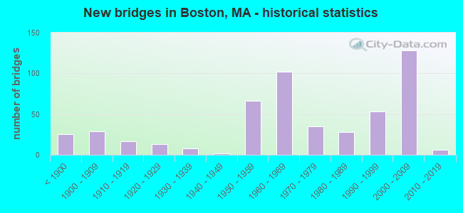
- New bridges - historical statistics
- 25Before 1900
- 291900-1909
- 171910-1919
- 131920-1929
- 81930-1939
- 21940-1949
- 661950-1959
- 1021960-1969
- 351970-1979
- 281980-1989
- 531990-1999
- 1282000-2009
- 62010-2019

- Reconstructed bridges - Historical Statistics
- 11920-1929
- 01930-1939
- 11940-1949
- 71950-1959
- 81960-1969
- 381970-1979
- 191980-1989
- 241990-1999
- 202000-2009
- 92010-2019


- Bridge Condition - Deck
- 0.5%Excellent
- 1.1%Very good
- 44.7%Good
- 33.3%Satisfactory
- 15.6%Fair
- 4.8%Poor

- Bridge Condition - Superstructure
- 2.2%Excellent
- 35.6%Very good
- 32.7%Good
- 23.7%Satisfactory
- 4.4%Fair
- 1.3%Poor
- 0.9%Serious

- Bridge Condition - Substructure
- 41.8%Excellent
- 30.1%Very good
- 22.9%Good
- 4.4%Satisfactory
- 0.9%Fair
- 4.4%Poor

- Bridge Condition - Channel
- 3.0%Very good
- 54.5%Good
- 24.2%Satisfactory
- 15.2%Fair
- 3.0%Poor
Find on map >> Show street view
Structure Number: B16003381MUNNBI, Location: OVER NEPONSET RIV AT MILT (Lat: 42.270969, Lng: -71.068147), Route carried "on" structure: City street , Year Built: 1765, Year Reconstructed: 2006, Status: Open, Structure Length: 3.63m (11.91ft), Average Daily Traffic: 30,800 (year 2018), Truck Traffic: 3%, Average Future Daily Traffic: 34,113 (year 2031), Design Load: HS 20, Features Intersected: WATER NEPONSET RIVER, Facility Carried by Structure: HWY ADAMS ST
Minimum Vertical Clearance: 30+ m (98+ ft), Kilometerpoint: 0.016, Lanes on structure: 2, Base Highway Network: Yes, Owner: City or Municipal Highway Agency, Approaching Roadway Width: 13.1m (43.0ft), Skew: 2 degrees, Material/Design: Masonry, Design/Construction: Arch - Deck, Number Of Spans In Main Unit: 2, Number Of Approach Spans: 3, Length of Maximum Span: 9.8m (32.2ft), Curb or Sidewalk Widths: Left: 2.1m (6.9ft), Right: 2.0m (6.6ft), Curb-To-Curb Width: 12.9m (42.3ft), Out-to-Out Width: 18.2m (59.7ft)
Condition: Deck: Good, Superstructure: Satisfactory, Substructure: Satisfactory, Channel: Satisfactory, Operating Rating: 62.2 metric tons, Method Used To Determine Operating Rating: Load Factor (LF), Inventory Rating: 37.3 metric tons, Method Used To Determine Inventory Rating: Load Factor (LF), Structural Evaluation: Equal to present minimum criteria, Deck Geometry: Somewhat better than minimum adequacy, Waterway Adequacy: Better than present minimum criteria, Approach Roadway Alignment: Somewhat better than minimum adequacy, Length Of Structure Improvement: 3.70m (12.14ft), Designated Inspection Frequency: Every 24 months, Underwater Inspection Frequency: Every 24 months, Inspection Date: November 2020, Underwater Inspection Date: August 2020, Bridge Improvement Cost: $175,000, Roadway Improvement Cost: $18,000, Total Project Cost: $263,000 ( Estimate for 2022), Deck Structure Type: Other, Wearing Surface/Protective System: Wearing Surface: Bituminous
Find on map >> Show street view
Structure Number: B16004B5JMUNNBI, Location: AT WINTHROP TOWN LINE (Lat: 42.382633, Lng: -70.994264), Route carried "on" structure: State highway 145, Year Built: 2013, Status: Open, Structure Length: 6.22m (20.41ft), Average Daily Traffic: 34,100 (year 2019), Truck Traffic: 3%, Design Load: HS 25 or greater, Features Intersected: WATER BELLE ISLE INLET
Minimum Vertical Clearance: 30+ m (98+ ft), Kilometerpoint: 2.704, Lanes on structure: 2, Owner: City or Municipal Highway Agency, Approaching Roadway Width: 13.4m (44.0ft), Navigation Control: Yes ( Vertical Clearance: 1.8m (5.9ft), Horizontal Clearance: 7.6m (24.9ft)), Material/Design: Prestressed concrete continuous, Design/Construction: Slab, Number Of Spans In Main Unit: 5, Length of Maximum Span: 11.8m (38.7ft), Curb or Sidewalk Widths: Left: 2.1m (6.9ft), Right: 2.1m (6.9ft), Curb-To-Curb Width: 13.4m (44.0ft), Out-to-Out Width: 18.4m (60.4ft)
Condition: Deck: Good, Superstructure: Good, Substructure: Good, Channel: Very good, Operating Rating: 66.9 metric tons, Method Used To Determine Operating Rating: Load Factor (LF), Inventory Rating: 61.8 metric tons, Method Used To Determine Inventory Rating: Load Factor (LF), Structural Evaluation: Better than present minimum criteria, Deck Geometry: Equal to present minimum criteria, Waterway Adequacy: Better than present minimum criteria, Approach Roadway Alignment: Better than present minimum criteria, Designated Inspection Frequency: Every 24 months, Underwater Inspection Frequency: Every 36 months, Inspection Date: July 2021, Underwater Inspection Date: May 2019, Deck Structure Type: Concrete Cast-file-Place, Wearing Surface/Protective System: Wearing Surface: Monolithic Concrete, Deck Protection: Epoxy Coated Reinforcing
Find on map >> Show street view
Structure Number: B160064F3DOTNBI, Location: .64 KM E OF N HARVARD ST (Lat: 42.361242, Lng: -71.116753), Route carried "on" structure: City street , Year Built: 1925, Status: Open, Structure Length: 6.40m (21.00ft), Average Daily Traffic: 44,700 (year 2019), Truck Traffic: 6%, Average Future Daily Traffic: 50,696 (year 2032), Features Intersected: WATER CHARLES RIVER, Facility Carried by Structure: HWY CAMBRIDGE ST
Minimum Vertical Clearance: 30+ m (98+ ft), Kilometerpoint: 0.016, Lanes on structure: 4, Owner: State Highway Agency, Approaching Roadway Width: 12.2m (40.0ft), Skew: 2 degrees, Navigation Control: Yes ( Vertical Clearance: 4.9m (16.1ft), Horizontal Clearance: 21.3m (69.9ft)), Material/Design: Concrete, Design/Construction: Arch - Deck, Number Of Spans In Main Unit: 3, Length of Maximum Span: 22.9m (75.1ft), Curb or Sidewalk Widths: Left: 2.6m (8.5ft), Right: 2.6m (8.5ft), Curb-To-Curb Width: 12.2m (40.0ft), Out-to-Out Width: 18.7m (61.4ft)
Condition: Superstructure: Poor, Substructure: Fair, Channel: Fair, Operating Rating: 54.1 metric tons, Method Used To Determine Operating Rating: Load Factor (LF), Inventory Rating: 32.5 metric tons, Method Used To Determine Inventory Rating: Load Factor (LF), Structural Evaluation: Meets minimum limits, Deck Geometry: High priority of replacement, Waterway Adequacy: Better than present minimum criteria, Approach Roadway Alignment: Meets minimum limits, Length Of Structure Improvement: 6.50m (21.33ft), Designated Inspection Frequency: Every 12 months, Underwater Inspection Frequency: Every 24 months, Other Special Inspection Frequency: Every 12 months, Inspection Date: July 2021, Underwater Inspection Date: April 2020, Other Special Inspection Date: July 2021, Bridge Improvement Cost: $4,775,000, Roadway Improvement Cost: $478,000, Total Project Cost: $7,163,000 ( Estimate for 2022)
Find on map >> Show street view
Structure Number: B160074EGDOTNBI, Location: CITY LINE BOS CAMB (Lat: 42.352619, Lng: -71.110639), Route carried "on" structure: Alternate State highway 2, Year Built: 1928, Status: Open, Structure Length: 22.07m (72.41ft), Average Daily Traffic: 37,370 (year 2020), Truck Traffic: 2%, Average Future Daily Traffic: 64,751 (year 2032), Design Load: HS 20, Features Intersected: COMB SOL FLD RD & RIV
Minimum Vertical Clearance: 4.27m (14.01ft), Kilometerpoint: 0.016, Lanes on structure: 4, Lanes under structure: 4, Base Highway Network: Yes, Owner: State Highway Agency, Approaching Roadway Width: 12.2m (40.0ft), Material/Design: Steel, Design/Construction: Arch - Thru, Number Of Spans In Main Unit: 1, Number Of Approach Spans: 6, Length of Maximum Span: 51.8m (169.9ft), Curb or Sidewalk Widths: Left: 2.6m (8.5ft), Right: 2.6m (8.5ft), Curb-To-Curb Width: 12.2m (40.0ft), Out-to-Out Width: 19.2m (63.0ft)
Condition: Deck: Satisfactory, Superstructure: Fair, Substructure: Fair, Channel: Good, Operating Rating: 55.4 metric tons, Method Used To Determine Operating Rating: Load Factor (LF), Inventory Rating: 33.0 metric tons, Method Used To Determine Inventory Rating: Load Factor (LF), Structural Evaluation: Somewhat better than minimum adequacy, Deck Geometry: High priority of replacement, Underclear: High priority of corrective action, Waterway Adequacy: Better than present minimum criteria, Approach Roadway Alignment: Equal to present minimum criteria, Length Of Structure Improvement: 22.10m (72.51ft), Designated Inspection Frequency: Every 24 months, Critical Feature Inspection Frequency: Every 24 months, Underwater Inspection Frequency: Every 48 months, Inspection Date: January 2022, Critical Feature Inspection Date: January 2022, Underwater Inspection Date: November 2018, Bridge Improvement Cost: $16,668,000, Roadway Improvement Cost: $1,667,000, Total Project Cost: $25,003,000 ( Estimate for 2022), Deck Structure Type: Concrete Cast-file-Place, Wearing Surface/Protective System: Wearing Surface: Bituminous
Find on map >> Show street view
Structure Number: B160094F0DOTNBI, Location: .2 MI W OF BLOSSOM ST (Lat: 42.361525, Lng: -71.075469), Route carried "on" structure: State highway 3, Year Built: 1905, Year Reconstructed: 2018, Status: Open, Structure Length: 65.07m (213.48ft), Average Daily Traffic: 29,100 (year 2018), Truck Traffic: 5%, Average Future Daily Traffic: 35,692 (year 2031), Features Intersected: COMB ST3/ST28 & CHARLES
Minimum Vertical Clearance: 30+ m (98+ ft), Kilometerpoint: 0.016, Lanes on structure: 6, Lanes under structure: 6, Base Highway Network: Yes, Owner: State Highway Agency, Approaching Roadway Width: 17.1m (56.1ft), Skew: 30 degrees, Navigation Control: Yes ( Vertical Clearance: 9.1m (29.9ft), Horizontal Clearance: 57.3m (188.0ft)), Material/Design: Steel, Design/Construction: Arch - Deck, Number Of Spans In Main Unit: 11, Number Of Approach Spans: 2, Length of Maximum Span: 74.1m (243.1ft), Curb or Sidewalk Widths: Left: 3.0m (9.8ft), Right: 1.8m (5.9ft), Curb-To-Curb Width: 27.6m (90.6ft), Out-to-Out Width: 32.5m (106.6ft)
Condition: Deck: Good, Superstructure: Good, Substructure: Satisfactory, Channel: Good, Operating Rating: 57.9 metric tons, Method Used To Determine Operating Rating: Load Factor (LF), Inventory Rating: 39.4 metric tons, Method Used To Determine Inventory Rating: Load Factor (LF), Structural Evaluation: Equal to present minimum criteria, Deck Geometry: Better than present minimum criteria, Underclear: High priority of corrective action, Waterway Adequacy: Superior to present desirable criteria, Approach Roadway Alignment: Meets minimum limits, Designated Inspection Frequency: Every 24 months, Underwater Inspection Frequency: Every 58 months, Inspection Date: September 2020, Underwater Inspection Date: July 2018, Deck Structure Type: Concrete Cast-file-Place, Wearing Surface/Protective System: Wearing Surface: Bituminous
Find on map >> Show street view
Structure Number: B160104EPDOTNBI, Location: CITY LINE BOS CAMB (Lat: 42.364250, Lng: -71.116903), Route carried "on" structure: City street , Year Built: 1924, Status: Open, Structure Length: 8.53m (27.99ft), Average Daily Traffic: 24,400 (year 2019), Truck Traffic: 4%, Average Future Daily Traffic: 47,379 (year 2032), Features Intersected: WATER CHARLES RIVER, Facility Carried by Structure: HWY WESTERN AVE
Minimum Vertical Clearance: 30+ m (98+ ft), Kilometerpoint: 0.016, Lanes on structure: 3, Base Highway Network: Yes, Owner: State Highway Agency, Approaching Roadway Width: 12.2m (40.0ft), Navigation Control: Yes ( Vertical Clearance: 3.7m (12.1ft), Horizontal Clearance: 25.9m (85.0ft)), Material/Design: Concrete, Design/Construction: Arch - Deck, Number Of Spans In Main Unit: 3, Length of Maximum Span: 26.8m (87.9ft), Curb or Sidewalk Widths: Left: 2.6m (8.5ft), Right: 2.6m (8.5ft), Curb-To-Curb Width: 12.2m (40.0ft), Out-to-Out Width: 18.3m (60.0ft)
Condition: Superstructure: Fair, Substructure: Satisfactory, Channel: Good, Inventory Rating: 71.4 metric tons, Method Used To Determine Inventory Rating: Load Factor (LF), Structural Evaluation: Somewhat better than minimum adequacy, Deck Geometry: Meets minimum limits, Waterway Adequacy: Equal to present minimum criteria, Approach Roadway Alignment: Somewhat better than minimum adequacy, Length Of Structure Improvement: 8.60m (28.22ft), Designated Inspection Frequency: Every 24 months, Underwater Inspection Frequency: Every 36 months, Inspection Date: November 2021, Underwater Inspection Date: November 2018, Bridge Improvement Cost: $6,182,000, Roadway Improvement Cost: $619,000, Total Project Cost: $9,274,000 ( Estimate for 2022)
Find on map >> Show street view
Structure Number: B160114F2DOTNBI, Location: .4 MI E OF WESTERN AVE (Lat: 42.368964, Lng: -71.123158), Route carried "on" structure: City street , Year Built: 1912, Year Reconstructed: 2012, Status: Open, Structure Length: 7.07m (23.20ft), Average Daily Traffic: 30,400 (year 2019), Truck Traffic: 9%, Average Future Daily Traffic: 45,800 (year 2032), Features Intersected: COMB CHARLES RV, Facility Carried by Structure: HWY N HARVARD ST
Minimum Vertical Clearance: 30+ m (98+ ft), Kilometerpoint: 0.016, Lanes on structure: 4, Base Highway Network: Yes, Owner: State Highway Agency, Approaching Roadway Width: 12.2m (40.0ft), Navigation Control: Yes ( Vertical Clearance: 3.7m (12.1ft), Horizontal Clearance: 25.9m (85.0ft)), Material/Design: Concrete, Design/Construction: Arch - Deck, Number Of Spans In Main Unit: 3, Length of Maximum Span: 23.5m (77.1ft), Curb or Sidewalk Widths: Left: 3.0m (9.8ft), Right: 3.0m (9.8ft), Curb-To-Curb Width: 12.2m (40.0ft), Out-to-Out Width: 19.3m (63.3ft)
Condition: Superstructure: Satisfactory, Substructure: Satisfactory, Channel: Good, Inventory Rating: 79.8 metric tons, Method Used To Determine Inventory Rating: Load Factor (LF), Structural Evaluation: Equal to present minimum criteria, Deck Geometry: High priority of replacement, Waterway Adequacy: Better than present minimum criteria, Approach Roadway Alignment: Equal to present minimum criteria, Length Of Structure Improvement: 7.10m (23.29ft), Designated Inspection Frequency: Every 24 months, Underwater Inspection Frequency: Every 36 months, Inspection Date: November 2021, Underwater Inspection Date: November 2018, Bridge Improvement Cost: $6,628,000, Roadway Improvement Cost: $663,000, Total Project Cost: $9,943,000 ( Estimate for 2022)
Find on map >> Show street view
Structure Number: B160124EYDOTNBI, Location: .8 MI E OF BU BRIDGE (Lat: 42.354389, Lng: -71.091197), Route carried "on" structure: Alternate State highway 2A, Year Built: 1891, Year Reconstructed: 1990, Status: Open, Structure Length: 66.18m (217.13ft), Average Daily Traffic: 32,273 (year 2018), Truck Traffic: 8%, Average Future Daily Traffic: 77,386 (year 2032), Design Load: HS 20, Features Intersected: COMB STRW DR & CHAS RIV, Facility Carried by Structure: ST 2 A/MASS AVE
Minimum Vertical Clearance: 30+ m (98+ ft), Kilometerpoint: 4.474, Lanes on structure: 4, Lanes under structure: 4, Base Highway Network: Yes, Owner: State Highway Agency, Approaching Roadway Width: 15.8m (51.8ft), Navigation Control: Yes ( Vertical Clearance: 3.7m (12.1ft), Horizontal Clearance: 18.3m (60.0ft)), Material/Design: Steel continuous, Design/Construction: Stringer/Multi-beam, Number Of Spans In Main Unit: 25, Length of Maximum Span: 32.1m (105.3ft), Curb or Sidewalk Widths: Left: 2.7m (8.9ft), Right: 2.7m (8.9ft), Curb-To-Curb Width: 15.8m (51.8ft), Out-to-Out Width: 22.6m (74.1ft)
Condition: Deck: Good, Superstructure: Satisfactory, Substructure: Good, Channel: Good, Operating Rating: 78.4 metric tons, Method Used To Determine Operating Rating: Load Factor (LF), Inventory Rating: 47.0 metric tons, Method Used To Determine Inventory Rating: Load Factor (LF), Structural Evaluation: Equal to present minimum criteria, Deck Geometry: Meets minimum limits, Underclear: High priority of corrective action, Waterway Adequacy: Equal to present desirable criteria, Approach Roadway Alignment: Equal to present desirable criteria, Length Of Structure Improvement: 66.20m (217.19ft), Designated Inspection Frequency: Every 24 months, Critical Feature Inspection Frequency: Every 24 months, Underwater Inspection Frequency: Every 36 months, Inspection Date: May 2021, Critical Feature Inspection Date: May 2021, Underwater Inspection Date: September 2020, Bridge Improvement Cost: $39,323,000, Roadway Improvement Cost: $3,933,000, Total Project Cost: $58,985,000 ( Estimate for 2022), Deck Structure Type: Concrete Cast-file-Place, Wearing Surface/Protective System: Wearing Surface: Bituminous, Membrane: Built-up, Deck Protection: Epoxy Coated Reinforcing
Find on map >> Show street view
Structure Number: B160134EMDOTNBI, Location: .1 MI NW OF NASHUA ST (Lat: 42.367153, Lng: -71.069106), Route carried "on" structure: State highway 28, Year Built: 1910, Year Reconstructed: 2011, Status: Open, Structure Length: 2.77m (9.09ft), Average Daily Traffic: 43,250 (year 2017), Truck Traffic: 4%, Average Future Daily Traffic: 69,489 (year 2032), Design Load: HS 25 or greater, Features Intersected: WATER CHARLES RIVER
Minimum Vertical Clearance: 30+ m (98+ ft), Kilometerpoint: 0.016, Lanes on structure: 5, Base Highway Network: Yes, Owner: State Highway Agency, Approaching Roadway Width: 18.4m (60.4ft), Skew: 30 degrees, Navigation Control: Yes ( Vertical Clearance: 4.6m (15.1ft), Horizontal Clearance: 13.7m (44.9ft)), Material/Design: Steel, Design/Construction: Movable - Bascule, Number Of Spans In Main Unit: 1, Number Of Approach Spans: 2, Length of Maximum Span: 19.2m (63.0ft), Curb or Sidewalk Widths: Left: 3.1m (10.2ft), Right: 2.9m (9.5ft), Curb-To-Curb Width: 18.4m (60.4ft), Out-to-Out Width: 25.7m (84.3ft)
Condition: Deck: Good, Superstructure: Good, Substructure: Satisfactory, Channel: Good, Operating Rating: 68.8 metric tons, Method Used To Determine Operating Rating: Load Factor (LF), Inventory Rating: 49.7 metric tons, Method Used To Determine Inventory Rating: Load Factor (LF), Structural Evaluation: Equal to present minimum criteria, Deck Geometry: High priority of replacement, Waterway Adequacy: Equal to present minimum criteria, Approach Roadway Alignment: Better than present minimum criteria, Length Of Structure Improvement: 2.80m (9.19ft), Designated Inspection Frequency: Every 24 months, Critical Feature Inspection Frequency: Every 24 months, Underwater Inspection Frequency: Every 48 months, Inspection Date: December 2021, Critical Feature Inspection Date: December 2021, Underwater Inspection Date: March 2021, Bridge Improvement Cost: $1,954,000, Roadway Improvement Cost: $196,000, Total Project Cost: $2,932,000 ( Estimate for 2022), Deck Structure Type: Closed Grating, Wearing Surface/Protective System: Wearing Surface: Other
Find on map >> Show street view
Structure Number: B160134ETDOTNBI, Location: .2 MI NW OF NASHUA ST (Lat: 42.368614, Lng: -71.071864), Route carried "on" structure: US 3, Year Built: 1906, Year Reconstructed: 2011, Status: Open, Structure Length: 3.54m (11.61ft), Average Daily Traffic: 61,200 (year 2020), Truck Traffic: 4%, Average Future Daily Traffic: 78,175 (year 2031), Features Intersected: WATER CHARLES RIVER, Facility Carried by Structure: ST 28 CHAS R DM RD
Minimum Vertical Clearance: 30+ m (98+ ft), Kilometerpoint: 0.016, Lanes on structure: 6, Base Highway Network: Yes, Owner: State Highway Agency, Approaching Roadway Width: 20.1m (65.9ft), Material/Design: Steel, Design/Construction: Stringer/Multi-beam, Number Of Spans In Main Unit: 10, Length of Maximum Span: 5.5m (18.0ft), Curb or Sidewalk Widths: Left: 3.0m (9.8ft), Right: 3.0m (9.8ft), Curb-To-Curb Width: 19.8m (65.0ft), Out-to-Out Width: 26.2m (86.0ft)
Condition: Deck: Satisfactory, Superstructure: Fair, Substructure: Poor, Channel: Poor, Operating Rating: 60.6 metric tons, Method Used To Determine Operating Rating: Load Factor (LF), Inventory Rating: 36.3 metric tons, Method Used To Determine Inventory Rating: Load Factor (LF), Structural Evaluation: Meets minimum limits, Deck Geometry: High priority of replacement, Waterway Adequacy: Better than present minimum criteria, Approach Roadway Alignment: Equal to present desirable criteria, Length Of Structure Improvement: 3.60m (11.81ft), Designated Inspection Frequency: Every 24 months, Underwater Inspection Frequency: Every 24 months, Inspection Date: Febuary 2020, Underwater Inspection Date: May 2020, Bridge Improvement Cost: $3,705,000, Roadway Improvement Cost: $371,000, Total Project Cost: $5,558,000 ( Estimate for 2022), Deck Structure Type: Concrete Cast-file-Place, Wearing Surface/Protective System: Wearing Surface: Bituminous
Find on map >> Show street view
Structure Number: B160144F8DOTNBI, Location: .1 MI N OF I 90 (Lat: 42.358983, Lng: -71.161542), Route carried "on" structure: US 20, Year Built: 1915, Status: Open, Structure Length: 6.25m (20.51ft), Average Daily Traffic: 26,500 (year 2019), Truck Traffic: 2%, Average Future Daily Traffic: 48,169 (year 2032), Design Load: H 20, Features Intersected: WATER CHARLES RIVER
Minimum Vertical Clearance: 30+ m (98+ ft), Kilometerpoint: 241.422, Lanes on structure: 4, Base Highway Network: Yes, Owner: State Highway Agency, Approaching Roadway Width: 16.8m (55.1ft), Skew: 2 degrees, Navigation Control: Yes ( Vertical Clearance: 4.3m (14.1ft), Horizontal Clearance: 13.7m (44.9ft)), Material/Design: Concrete, Design/Construction: Arch - Deck, Number Of Spans In Main Unit: 3, Length of Maximum Span: 22.9m (75.1ft), Curb or Sidewalk Widths: Left: 3.2m (10.5ft), Right: 3.2m (10.5ft), Curb-To-Curb Width: 16.5m (54.1ft), Out-to-Out Width: 24.1m (79.1ft)
Condition: Superstructure: Fair, Substructure: Fair, Channel: Good, Operating Rating: 91.3 metric tons, Method Used To Determine Operating Rating: Load Factor (LF), Inventory Rating: 54.7 metric tons, Method Used To Determine Inventory Rating: Load Factor (LF), Structural Evaluation: Somewhat better than minimum adequacy, Deck Geometry: Meets minimum limits, Waterway Adequacy: Somewhat better than minimum adequacy, Approach Roadway Alignment: Meets minimum limits, Length Of Structure Improvement: 6.30m (20.67ft), Designated Inspection Frequency: Every 24 months, Underwater Inspection Frequency: Every 36 months, Inspection Date: July 2021, Underwater Inspection Date: September 2021, Bridge Improvement Cost: $5,964,000, Roadway Improvement Cost: $597,000, Total Project Cost: $8,947,000 ( Estimate for 2022)
Find on map >> Show street view
Structure Number: B160154EFDOTNBI, Location: CITY LINE WAT BOS (Lat: 42.361708, Lng: -71.147244), Route carried "on" structure: City street , Year Built: 1925, Year Reconstructed: 1968, Status: Open, Structure Length: 6.19m (20.31ft), Average Daily Traffic: 24,700 (year 2021), Truck Traffic: 7%, Average Future Daily Traffic: 63,172 (year 2032), Features Intersected: WATER CHARLES RIVER, Facility Carried by Structure: HWY ARSENAL ST
Minimum Vertical Clearance: 30+ m (98+ ft), Kilometerpoint: 0.016, Lanes on structure: 4, Owner: State Highway Agency, Approaching Roadway Width: 15.8m (51.8ft), Skew: 24 degrees, Navigation Control: Yes ( Vertical Clearance: 4.0m (13.1ft), Horizontal Clearance: 22.9m (75.1ft)), Material/Design: Concrete, Design/Construction: Arch - Deck, Number Of Spans In Main Unit: 2, Length of Maximum Span: 21.3m (69.9ft), Curb or Sidewalk Widths: Left: 1.8m (5.9ft), Right: 1.8m (5.9ft), Curb-To-Curb Width: 15.3m (50.2ft), Out-to-Out Width: 19.5m (64.0ft)
Condition: Superstructure: Fair, Substructure: Satisfactory, Channel: Satisfactory, Operating Rating: 83.3 metric tons, Method Used To Determine Operating Rating: Load Factor (LF), Inventory Rating: 38.3 metric tons, Method Used To Determine Inventory Rating: Load Factor (LF), Structural Evaluation: Somewhat better than minimum adequacy, Deck Geometry: High priority of corrective action, Waterway Adequacy: Better than present minimum criteria, Approach Roadway Alignment: Equal to present minimum criteria, Length Of Structure Improvement: 6.20m (20.34ft), Designated Inspection Frequency: Every 24 months, Underwater Inspection Frequency: Every 48 months, Inspection Date: November 2021, Underwater Inspection Date: November 2018, Bridge Improvement Cost: $4,749,000, Roadway Improvement Cost: $475,000, Total Project Cost: $7,124,000 ( Estimate for 2022)
Find on map >> Show street view
Structure Number: B1601637HMUNNBI, Location: AT CHAS RIV NR BOS GARDEN (Lat: 42.367797, Lng: -71.059139), Route carried "on" structure: City street , Year Built: 1900, Year Reconstructed: 1956, Status: Temporarily open, Structure Length: 12.92m (42.39ft), Average Daily Traffic: 43,300 (year 2016), Truck Traffic: 10%, Average Future Daily Traffic: 60,645 (year 2031), Design Load: HS 20, Features Intersected: WATER CHARLES RIVER, Facility Carried by Structure: HWY N WSHNGTN ST
Minimum Vertical Clearance: 30+ m (98+ ft), Kilometerpoint: 0.531, Lanes on structure: 6, Base Highway Network: Yes, Owner: City or Municipal Highway Agency, Approaching Roadway Width: 24.4m (80.1ft), Skew: 20 degrees, Material/Design: Steel, Design/Construction: Girder and Floorbeam System, Number Of Spans In Main Unit: 5, Length of Maximum Span: 25.9m (85.0ft), Curb or Sidewalk Widths: Left: 2.6m (8.5ft), Right: 2.3m (7.5ft), Curb-To-Curb Width: 22.6m (74.1ft), Out-to-Out Width: 30.8m (101.0ft)
Condition: Deck: Fair, Superstructure: Serious, Substructure: Poor, Channel: Fair, Structural Evaluation: High priority of replacement, Deck Geometry: Meets minimum limits, Waterway Adequacy: Superior to present desirable criteria, Approach Roadway Alignment: Somewhat better than minimum adequacy, Length Of Structure Improvement: 13.80m (45.28ft), Designated Inspection Frequency: Every 24 months, Underwater Inspection Frequency: Every 48 months, Inspection Date: September 2020, Underwater Inspection Date: August 2018, Bridge Improvement Cost: $25,951,000, Roadway Improvement Cost: $2,596,000, Total Project Cost: $38,927,000 ( Estimate for 2022), Deck Structure Type: Concrete Cast-file-Place, Wearing Surface/Protective System: Wearing Surface: Bituminous, Membrane: Other
Find on map >> Show street view
Structure Number: B1601637KMUNNBI, Location: AT CHAS RIV NR BOS GARDEN (Lat: 42.368733, Lng: -71.059800), Route carried "on" structure: City street , Year Built: 1900, Year Reconstructed: 1956, Status: Temporarily open, Structure Length: 7.35m (24.11ft), Average Daily Traffic: 43,300 (year 2016), Truck Traffic: 10%, Average Future Daily Traffic: 60,645 (year 2031), Design Load: HS 20, Features Intersected: WATER CHARLES RIVER, Facility Carried by Structure: HWY N WSHNGTN ST
Minimum Vertical Clearance: 4.85m (15.91ft), Kilometerpoint: 0.660, Lanes on structure: 6, Base Highway Network: Yes, Owner: City or Municipal Highway Agency, Approaching Roadway Width: 24.4m (80.1ft), Skew: 30 degrees, Navigation Control: Yes ( Vertical Clearance: 7.0m (23.0ft), Horizontal Clearance: 15.2m (49.9ft)), Material/Design: Steel continuous, Design/Construction: Truss - Thru, Number Of Spans In Main Unit: 2, Length of Maximum Span: 36.3m (119.1ft), Curb or Sidewalk Widths: Left: 3.0m (9.8ft), Right: 2.8m (9.2ft), Curb-To-Curb Width: 20.1m (65.9ft), Out-to-Out Width: 30.8m (101.0ft)
Condition: Deck: Satisfactory, Superstructure: Serious, Substructure: Poor, Channel: Fair, Structural Evaluation: High priority of replacement, Deck Geometry: High priority of replacement, Waterway Adequacy: Superior to present desirable criteria, Approach Roadway Alignment: Somewhat better than minimum adequacy, Length Of Structure Improvement: 8.40m (27.56ft), Designated Inspection Frequency: Every 24 months, Underwater Inspection Frequency: Every 48 months, Inspection Date: September 2020, Underwater Inspection Date: August 2018, Bridge Improvement Cost: $16,896,000, Roadway Improvement Cost: $1,690,000, Total Project Cost: $25,345,000 ( Estimate for 2022), Deck Structure Type: Open Grating, Wearing Surface/Protective System: Wearing Surface: Other
Find on map >> Show street view
Structure Number: B1601637MMUNNBI, Location: AT CHAS RIV NR BOS GARDEN (Lat: 42.369478, Lng: -71.060314), Route carried "on" structure: City street , Year Built: 1900, Year Reconstructed: 1956, Status: Temporarily open, Structure Length: 12.92m (42.39ft), Average Daily Traffic: 43,300 (year 2016), Truck Traffic: 10%, Average Future Daily Traffic: 60,645 (year 2031), Features Intersected: WATER CHARLES RIVER, Facility Carried by Structure: HWY N WSHNGTN ST
Minimum Vertical Clearance: 30+ m (98+ ft), Kilometerpoint: 0.740, Lanes on structure: 6, Base Highway Network: Yes, Owner: City or Municipal Highway Agency, Approaching Roadway Width: 24.4m (80.1ft), Material/Design: Steel, Design/Construction: Girder and Floorbeam System, Number Of Spans In Main Unit: 5, Length of Maximum Span: 25.9m (85.0ft), Curb or Sidewalk Widths: Left: 2.6m (8.5ft), Right: 2.3m (7.5ft), Curb-To-Curb Width: 24.4m (80.1ft), Out-to-Out Width: 30.8m (101.0ft)
Condition: Deck: Poor, Superstructure: Serious, Substructure: Poor, Channel: Fair, Structural Evaluation: High priority of replacement, Deck Geometry: Somewhat better than minimum adequacy, Waterway Adequacy: Superior to present desirable criteria, Approach Roadway Alignment: Somewhat better than minimum adequacy, Length Of Structure Improvement: 13.80m (45.28ft), Designated Inspection Frequency: Every 24 months, Underwater Inspection Frequency: Every 48 months, Inspection Date: September 2020, Underwater Inspection Date: August 2018, Bridge Improvement Cost: $24,649,000, Roadway Improvement Cost: $2,465,000, Total Project Cost: $36,974,000 ( Estimate for 2022), Deck Structure Type: Concrete Cast-file-Place, Wearing Surface/Protective System: Wearing Surface: Bituminous, Membrane: Other
Find on map >> Show street view
Structure Number: B1601637PMUNNBI, Location: NEAR BOSTON GARDEN (Lat: 42.370483, Lng: -71.061047), Route carried "on" structure: City street , Year Built: 1900, Year Reconstructed: 1992, Status: Open, Structure Length: 8.29m (27.20ft), Average Daily Traffic: 43,600 (year 2020), Truck Traffic: 6%, Average Future Daily Traffic: 104,550 (year 2033), Design Load: HS 20, Features Intersected: OTHER WAREHOUSE, Facility Carried by Structure: HWY N WSHNGTN ST
Minimum Vertical Clearance: 5.44m (17.85ft), Kilometerpoint: 0.869, Lanes on structure: 6, Base Highway Network: Yes, Owner: City or Municipal Highway Agency, Approaching Roadway Width: 24.4m (80.1ft), Skew: 21 degrees, Material/Design: Steel, Design/Construction: Stringer/Multi-beam, Number Of Spans In Main Unit: 5, Number Of Approach Spans: 1, Length of Maximum Span: 15.2m (49.9ft), Curb or Sidewalk Widths: Left: 2.2m (7.2ft), Right: 2.2m (7.2ft), Curb-To-Curb Width: 24.7m (81.0ft), Out-to-Out Width: 31.2m (102.4ft)
Condition: Deck: Good, Superstructure: Good, Substructure: Satisfactory, Operating Rating: 52.5 metric tons, Method Used To Determine Operating Rating: Allowable Stress (AS), Inventory Rating: 33.0 metric tons, Method Used To Determine Inventory Rating: Allowable Stress (AS), Structural Evaluation: Equal to present minimum criteria, Deck Geometry: Somewhat better than minimum adequacy, Approach Roadway Alignment: Somewhat better than minimum adequacy, Length Of Structure Improvement: 8.30m (27.23ft), Designated Inspection Frequency: Every 24 months, Inspection Date: Febuary 2020, Bridge Improvement Cost: $2,348,000, Roadway Improvement Cost: $235,000, Total Project Cost: $3,523,000 ( Estimate for 2022), Deck Structure Type: Concrete Cast-file-Place, Wearing Surface/Protective System: Wearing Surface: Bituminous, Membrane: Built-up, Deck Protection: Epoxy Coated Reinforcing
Find on map >> Show street view
Structure Number: B1601637RMUNNBI, Location: NEAR BOSTON GARDEN (Lat: 42.370733, Lng: -71.061317), Route carried "on" structure: City street , Year Built: 1900, Year Reconstructed: 1992, Status: Open, Structure Length: 1.83m (6.00ft), Average Daily Traffic: 43,600 (year 2020), Truck Traffic: 6%, Average Future Daily Traffic: 101,707 (year 2033), Design Load: HS 20, Features Intersected: HWY WATER ST, Facility Carried by Structure: HWY N WSHNGTN ST
Minimum Vertical Clearance: 9.14m (29.99ft), Kilometerpoint: 0.982, Lanes on structure: 6, Lanes under structure: 2, Base Highway Network: Yes, Owner: City or Municipal Highway Agency, Approaching Roadway Width: 32.3m (106.0ft), Skew: 21 degrees, Material/Design: Steel, Design/Construction: Stringer/Multi-beam, Number Of Spans In Main Unit: 1, Length of Maximum Span: 17.4m (57.1ft), Curb or Sidewalk Widths: Left: 2.4m (7.9ft), Right: 2.4m (7.9ft), Curb-To-Curb Width: 33.5m (109.9ft), Out-to-Out Width: 42.1m (138.1ft)
Condition: Deck: Good, Superstructure: Good, Substructure: Good, Operating Rating: 51.2 metric tons, Method Used To Determine Operating Rating: Allowable Stress (AS), Inventory Rating: 32.4 metric tons, Method Used To Determine Inventory Rating: Allowable Stress (AS), Structural Evaluation: Better than present minimum criteria, Deck Geometry: Superior to present desirable criteria, Underclear: Meets minimum limits, Approach Roadway Alignment: Equal to present minimum criteria, Length Of Structure Improvement: 1.90m (6.23ft), Designated Inspection Frequency: Every 24 months, Inspection Date: Febuary 2020, Bridge Improvement Cost: $315,000, Roadway Improvement Cost: $32,000, Total Project Cost: $473,000 ( Estimate for 2022), Deck Structure Type: Concrete Cast-file-Place, Wearing Surface/Protective System: Wearing Surface: Bituminous, Membrane: Built-up, Deck Protection: Epoxy Coated Reinforcing
Find on map >> Show street view
Structure Number: B160174WUDOTNBI, Location: BOS APPR UP (Lat: 42.378572, Lng: -71.053208), Route carried "on" structure: US 1, Year Built: 1950, Status: Open, Structure Length: 63.16m (207.22ft), Average Daily Traffic: 33,373 (year 2018), Truck Traffic: 10%, Average Future Daily Traffic: 45,800 (year 2032), Design Load: HS 20, Features Intersected: US 1 NB/BOS LOWR B11-32
Minimum Vertical Clearance: 4.57m (14.99ft), Kilometerpoint: 67.269, Lanes on structure: 3, Lanes under structure: 3, Base Highway Network: Yes, Toll: Toll bridge, Owner: State Highway Agency, Approaching Roadway Width: 11.0m (36.1ft), Material/Design: Steel, Design/Construction: Girder and Floorbeam System, Number Of Spans In Main Unit: 21, Number Of Approach Spans: 1, Length of Maximum Span: 33.5m (109.9ft), Curb or Sidewalk Widths: Left: 0.7m (2.3ft), Right: 0.7m (2.3ft), Curb-To-Curb Width: 11.0m (36.1ft), Out-to-Out Width: 12.7m (41.7ft)
Condition: Deck: Satisfactory, Superstructure: Fair, Substructure: Fair, Operating Rating: 40.8 metric tons, Method Used To Determine Operating Rating: Load Factor (LF), Inventory Rating: 24.4 metric tons, Method Used To Determine Inventory Rating: Load Factor (LF), Structural Evaluation: Somewhat better than minimum adequacy, Deck Geometry: High priority of replacement, Underclear: Somewhat better than minimum adequacy, Approach Roadway Alignment: Better than present minimum criteria, Length Of Structure Improvement: 63.20m (207.35ft), Designated Inspection Frequency: Every 24 months, Critical Feature Inspection Frequency: Every 24 months, Inspection Date: September 2021, Critical Feature Inspection Date: September 2021, Bridge Improvement Cost: $31,528,000, Roadway Improvement Cost: $3,153,000, Total Project Cost: $47,293,000 ( Estimate for 2022), Deck Structure Type: Closed Grating, Wearing Surface/Protective System: Wearing Surface: Bituminous
Find on map >> Show street view
Structure Number: B160174WVDOTNBI, Location: BOS APPR LOWER (Lat: 42.377417, Lng: -71.054292), Route carried "on" structure: US 1, Year Built: 1950, Status: Open, Structure Length: 57.67m (189.21ft), Average Daily Traffic: 41,951 (year 2018), Truck Traffic: 5%, Average Future Daily Traffic: 70,595 (year 2032), Design Load: HS 20, Features Intersected: HWY CHRLTWN LOCAL STS
Minimum Vertical Clearance: 4.88m (16.01ft), Kilometerpoint: 67.269, Lanes on structure: 3, Lanes under structure: 4, Base Highway Network: Yes, Toll: Toll bridge, Owner: State Highway Agency, Approaching Roadway Width: 11.0m (36.1ft), Material/Design: Steel, Design/Construction: Girder and Floorbeam System, Number Of Spans In Main Unit: 19, Length of Maximum Span: 33.5m (109.9ft), Curb or Sidewalk Widths: Left: 0.7m (2.3ft), Right: 0.7m (2.3ft), Curb-To-Curb Width: 11.0m (36.1ft), Out-to-Out Width: 12.7m (41.7ft)
Condition: Deck: Satisfactory, Superstructure: Fair, Substructure: Fair, Operating Rating: 32.1 metric tons, Method Used To Determine Operating Rating: Load Factor (LF), Inventory Rating: 19.2 metric tons, Method Used To Determine Inventory Rating: Load Factor (LF), Structural Evaluation: Meets minimum limits, Deck Geometry: High priority of replacement, Underclear: Equal to present desirable criteria, Approach Roadway Alignment: Better than present minimum criteria, Bridge Posting: Required (Relationship of Operating Rating to Maximum Legal Load: 0.1 - 9.9% below), Length Of Structure Improvement: 57.70m (189.30ft), Designated Inspection Frequency: Every 24 months, Critical Feature Inspection Frequency: Every 24 months, Inspection Date: September 2021, Critical Feature Inspection Date: September 2021, Bridge Improvement Cost: $28,784,000, Roadway Improvement Cost: $2,879,000, Total Project Cost: $43,177,000 ( Estimate for 2022), Deck Structure Type: Closed Grating, Wearing Surface/Protective System: Wearing Surface: Bituminous
Find on map >> Show street view
Structure Number: B160174WWDOTNBI, Location: L MYSTIC LOWER (Lat: 42.380175, Lng: -71.051717), Route carried "on" structure: US 1, Year Built: 1950, Status: Open, Structure Length: 13.38m (43.90ft), Average Daily Traffic: 41,951 (year 2018), Truck Traffic: 7%, Average Future Daily Traffic: 70,595 (year 2032), Design Load: HS 20, Features Intersected: HWY CHELSEA STREET
Minimum Vertical Clearance: 4.90m (16.08ft), Kilometerpoint: 67.269, Lanes on structure: 3, Lanes under structure: 2, Base Highway Network: Yes, Toll: Toll bridge, Owner: State Highway Agency, Approaching Roadway Width: 11.0m (36.1ft), Navigation Control: Yes ( Vertical Clearance: 30.5m (100.1ft), Horizontal Clearance: 121.9m (399.9ft)), Material/Design: Steel, Design/Construction: Truss - Thru, Number Of Spans In Main Unit: 1, Length of Maximum Span: 133.8m (439.0ft), Curb or Sidewalk Widths: Left: 0.7m (2.3ft), Right: 0.7m (2.3ft), Curb-To-Curb Width: 11.0m (36.1ft), Out-to-Out Width: 12.7m (41.7ft)
Condition: Deck: Satisfactory, Superstructure: Fair, Substructure: Fair, Channel: Fair, Operating Rating: 45.0 metric tons, Method Used To Determine Operating Rating: Load Factor (LF), Inventory Rating: 27.0 metric tons, Method Used To Determine Inventory Rating: Load Factor (LF), Structural Evaluation: Somewhat better than minimum adequacy, Deck Geometry: High priority of replacement, Approach Roadway Alignment: Better than present minimum criteria, Length Of Structure Improvement: 13.40m (43.96ft), Designated Inspection Frequency: Every 24 months, Critical Feature Inspection Frequency: Every 24 months, Inspection Date: September 2021, Critical Feature Inspection Date: September 2021, Bridge Improvement Cost: $6,685,000, Roadway Improvement Cost: $669,000, Total Project Cost: $10,028,000 ( Estimate for 2022), Deck Structure Type: Closed Grating, Wearing Surface/Protective System: Wearing Surface: Bituminous
Find on map >> Show street view
Structure Number: B160174WXDOTNBI, Location: L MYSTIC UP (Lat: 42.380175, Lng: -71.051717), Route carried "on" structure: US 1, Year Built: 1950, Status: Open, Structure Length: 13.38m (43.90ft), Average Daily Traffic: 33,373 (year 2018), Truck Traffic: 9%, Average Future Daily Traffic: 45,800 (year 2032), Design Load: HS 20, Features Intersected: US 1 NB/LIT MYSTIC LOWR
Minimum Vertical Clearance: 4.90m (16.08ft), Kilometerpoint: 67.269, Lanes on structure: 3, Lanes under structure: 3, Base Highway Network: Yes, Toll: Toll bridge, Owner: State Highway Agency, Approaching Roadway Width: 11.0m (36.1ft), Material/Design: Steel, Design/Construction: Truss - Thru, Number Of Spans In Main Unit: 1, Length of Maximum Span: 133.8m (439.0ft), Curb or Sidewalk Widths: Left: 0.7m (2.3ft), Right: 0.7m (2.3ft), Curb-To-Curb Width: 11.0m (36.1ft), Out-to-Out Width: 12.7m (41.7ft)
Condition: Deck: Satisfactory, Superstructure: Fair, Substructure: Fair, Channel: Fair, Operating Rating: 43.8 metric tons, Method Used To Determine Operating Rating: Allowable Stress (AS), Inventory Rating: 27.7 metric tons, Method Used To Determine Inventory Rating: Allowable Stress (AS), Structural Evaluation: Somewhat better than minimum adequacy, Deck Geometry: High priority of replacement, Underclear: Somewhat better than minimum adequacy, Approach Roadway Alignment: Better than present minimum criteria, Length Of Structure Improvement: 13.40m (43.96ft), Designated Inspection Frequency: Every 24 months, Critical Feature Inspection Frequency: Every 24 months, Inspection Date: September 2021, Critical Feature Inspection Date: September 2021, Bridge Improvement Cost: $6,685,000, Roadway Improvement Cost: $669,000, Total Project Cost: $10,028,000 ( Estimate for 2022), Deck Structure Type: Closed Grating, Wearing Surface/Protective System: Wearing Surface: Bituminous
Find on map >> Show street view
Structure Number: B160174WYDOTNBI, Location: CHEL APPR LOW (Lat: 42.390056, Lng: -71.041742), Route carried "on" structure: US 1, Year Built: 1950, Status: Open, Structure Length: 86.23m (282.91ft), Average Daily Traffic: 41,951 (year 2018), Truck Traffic: 7%, Average Future Daily Traffic: 70,595 (year 2032), Design Load: HS 20, Features Intersected: HWY CHELSEA LOCAL STRE
Minimum Vertical Clearance: 4.88m (16.01ft), Kilometerpoint: 67.269, Lanes on structure: 3, Lanes under structure: 2, Base Highway Network: Yes, Toll: Toll bridge, Owner: State Highway Agency, Approaching Roadway Width: 11.0m (36.1ft), Material/Design: Steel, Design/Construction: Girder and Floorbeam System, Number Of Spans In Main Unit: 30, Length of Maximum Span: 31.4m (103.0ft), Curb or Sidewalk Widths: Left: 0.7m (2.3ft), Right: 0.7m (2.3ft), Curb-To-Curb Width: 11.0m (36.1ft), Out-to-Out Width: 12.7m (41.7ft)
Condition: Deck: Fair, Superstructure: Poor, Substructure: Fair, Operating Rating: 18.0 metric tons, Method Used To Determine Operating Rating: Load Factor (LF), Inventory Rating: 10.8 metric tons, Method Used To Determine Inventory Rating: Load Factor (LF), Structural Evaluation: High priority of replacement, Deck Geometry: High priority of replacement, Underclear: High priority of replacement, Approach Roadway Alignment: Better than present minimum criteria, Bridge Posting: Required (Relationship of Operating Rating to Maximum Legal Load: > 39.9% below), Length Of Structure Improvement: 86.30m (283.14ft), Designated Inspection Frequency: Every 12 months, Critical Feature Inspection Frequency: Every 24 months, Other Special Inspection Frequency: Every 12 months, Inspection Date: November 2021, Critical Feature Inspection Date: November 2021, Other Special Inspection Date: November 2021, Bridge Improvement Cost: $90,860,000, Roadway Improvement Cost: $9,087,000, Total Project Cost: $136,291,000 ( Estimate for 2022), Deck Structure Type: Closed Grating, Wearing Surface/Protective System: Wearing Surface: Bituminous
Find on map >> Show street view
Structure Number: B160174X0DOTNBI, Location: CHEL APPR UP (Lat: 42.390483, Lng: -71.041019), Route carried "on" structure: US 1, Year Built: 1950, Status: Open, Structure Length: 102.08m (334.91ft), Average Daily Traffic: 33,373 (year 2018), Truck Traffic: 9%, Average Future Daily Traffic: 45,800 (year 2032), Design Load: HS 20, Features Intersected: US 1 NB/CHEL LWR DECK
Minimum Vertical Clearance: 4.57m (14.99ft), Kilometerpoint: 67.269, Lanes on structure: 3, Lanes under structure: 3, Base Highway Network: Yes, Toll: Toll bridge, Owner: State Highway Agency, Approaching Roadway Width: 11.0m (36.1ft), Material/Design: Steel, Design/Construction: Girder and Floorbeam System, Number Of Spans In Main Unit: 36, Length of Maximum Span: 31.4m (103.0ft), Curb or Sidewalk Widths: Left: 0.7m (2.3ft), Right: 0.7m (2.3ft), Curb-To-Curb Width: 11.0m (36.1ft), Out-to-Out Width: 12.7m (41.7ft)
Condition: Deck: Fair, Superstructure: Poor, Substructure: Fair, Operating Rating: 34.7 metric tons, Method Used To Determine Operating Rating: Load Factor (LF), Inventory Rating: 20.7 metric tons, Method Used To Determine Inventory Rating: Load Factor (LF), Structural Evaluation: Meets minimum limits, Deck Geometry: High priority of replacement, Underclear: High priority of replacement, Approach Roadway Alignment: Better than present minimum criteria, Length Of Structure Improvement: 102.10m (334.97ft), Designated Inspection Frequency: Every 12 months, Critical Feature Inspection Frequency: Every 24 months, Other Special Inspection Frequency: Every 12 months, Inspection Date: November 2021, Critical Feature Inspection Date: November 2021, Other Special Inspection Date: November 2021, Bridge Improvement Cost: $107,495,000, Roadway Improvement Cost: $10,750,000, Total Project Cost: $161,243,000 ( Estimate for 2022), Deck Structure Type: Closed Grating, Wearing Surface/Protective System: Wearing Surface: Bituminous
Find on map >> Show street view
Structure Number: B160174X1DOTNBI, Location: TOLL PL LOWER (Lat: 42.381903, Lng: -71.050161), Route carried "on" structure: US 1, Year Built: 1950, Status: Open, Structure Length: 32.67m (107.19ft), Average Daily Traffic: 41,951 (year 2018), Truck Traffic: 7%, Average Future Daily Traffic: 70,595 (year 2032), Design Load: HS 20, Features Intersected: OTHER RELIEF
Minimum Vertical Clearance: 4.90m (16.08ft), Kilometerpoint: 67.269, Lanes on structure: 3, Base Highway Network: Yes, Toll: Toll bridge, Owner: State Highway Agency, Approaching Roadway Width: 11.0m (36.1ft), Material/Design: Steel, Design/Construction: Girder and Floorbeam System, Number Of Spans In Main Unit: 12, Length of Maximum Span: 35.4m (116.1ft), Curb or Sidewalk Widths: Left: 0.7m (2.3ft), Right: 0.7m (2.3ft), Curb-To-Curb Width: 11.0m (36.1ft), Out-to-Out Width: 12.7m (41.7ft)
Condition: Deck: Good, Superstructure: Fair, Substructure: Fair, Operating Rating: 35.3 metric tons, Method Used To Determine Operating Rating: Load Factor (LF), Inventory Rating: 22.2 metric tons, Method Used To Determine Inventory Rating: Load Factor (LF), Structural Evaluation: Somewhat better than minimum adequacy, Deck Geometry: High priority of replacement, Approach Roadway Alignment: Better than present minimum criteria, Length Of Structure Improvement: 32.70m (107.28ft), Designated Inspection Frequency: Every 24 months, Critical Feature Inspection Frequency: Every 24 months, Inspection Date: November 2021, Critical Feature Inspection Date: November 2021, Bridge Improvement Cost: $16,313,000, Roadway Improvement Cost: $1,632,000, Total Project Cost: $24,470,000 ( Estimate for 2022), Deck Structure Type: Closed Grating, Wearing Surface/Protective System: Wearing Surface: Bituminous
Find on map >> Show street view
Structure Number: B160174X2DOTNBI, Location: TOLL PL UPPER (Lat: 42.381903, Lng: -71.050161), Route carried "on" structure: US 1, Year Built: 1950, Status: Open, Structure Length: 32.67m (107.19ft), Average Daily Traffic: 33,373 (year 2018), Truck Traffic: 9%, Average Future Daily Traffic: 45,800 (year 2032), Design Load: HS 20, Features Intersected: US 1 NB/TOLL PLAZA LOWR
Minimum Vertical Clearance: 4.90m (16.08ft), Kilometerpoint: 67.269, Lanes on structure: 3, Lanes under structure: 3, Base Highway Network: Yes, Toll: Toll bridge, Owner: State Highway Agency, Approaching Roadway Width: 11.0m (36.1ft), Material/Design: Steel, Design/Construction: Girder and Floorbeam System, Number Of Spans In Main Unit: 12, Length of Maximum Span: 35.4m (116.1ft), Curb or Sidewalk Widths: Left: 0.7m (2.3ft), Right: 0.7m (2.3ft), Curb-To-Curb Width: 11.0m (36.1ft), Out-to-Out Width: 12.7m (41.7ft)
Condition: Deck: Satisfactory, Superstructure: Fair, Substructure: Fair, Operating Rating: 36.3 metric tons, Method Used To Determine Operating Rating: Load Factor (LF), Inventory Rating: 21.7 metric tons, Method Used To Determine Inventory Rating: Load Factor (LF), Structural Evaluation: Somewhat better than minimum adequacy, Deck Geometry: High priority of replacement, Underclear: Somewhat better than minimum adequacy, Approach Roadway Alignment: Better than present minimum criteria, Length Of Structure Improvement: 32.70m (107.28ft), Designated Inspection Frequency: Every 24 months, Critical Feature Inspection Frequency: Every 24 months, Inspection Date: November 2021, Critical Feature Inspection Date: November 2021, Bridge Improvement Cost: $16,313,000, Roadway Improvement Cost: $1,632,000, Total Project Cost: $24,470,000 ( Estimate for 2022), Deck Structure Type: Closed Grating, Wearing Surface/Protective System: Wearing Surface: Bituminous
Find on map >> Show street view
Structure Number: B160174X3DOTNBI, Location: BIG MYS LOWER (Lat: 42.385103, Lng: -71.047286), Route carried "on" structure: US 1, Year Built: 1950, Status: Open, Structure Length: 46.45m (152.40ft), Average Daily Traffic: 41,951 (year 2018), Truck Traffic: 7%, Average Future Daily Traffic: 70,595 (year 2032), Design Load: HS 20, Features Intersected: WATER MYSTIC RIVER
Minimum Vertical Clearance: 4.88m (16.01ft), Kilometerpoint: 67.269, Lanes on structure: 3, Base Highway Network: Yes, Toll: Toll bridge, Owner: State Highway Agency, Approaching Roadway Width: 11.0m (36.1ft), Navigation Control: Yes ( Vertical Clearance: 41.1m (134.8ft), Horizontal Clearance: 213.4m (700.1ft)), Material/Design: Steel continuous, Design/Construction: Truss - Thru, Number Of Spans In Main Unit: 3, Length of Maximum Span: 244.1m (800.9ft), Curb or Sidewalk Widths: Left: 0.7m (2.3ft), Right: 0.7m (2.3ft), Curb-To-Curb Width: 11.0m (36.1ft), Out-to-Out Width: 12.7m (41.7ft)
Condition: Deck: Good, Superstructure: Fair, Substructure: Fair, Channel: Good, Operating Rating: 36.4 metric tons, Method Used To Determine Operating Rating: Load Factor (LF), Inventory Rating: 21.8 metric tons, Method Used To Determine Inventory Rating: Load Factor (LF), Structural Evaluation: Somewhat better than minimum adequacy, Deck Geometry: High priority of replacement, Waterway Adequacy: Equal to present desirable criteria, Approach Roadway Alignment: Better than present minimum criteria, Length Of Structure Improvement: 46.50m (152.56ft), Designated Inspection Frequency: Every 24 months, Critical Feature Inspection Frequency: Every 24 months, Underwater Inspection Frequency: Every 36 months, Inspection Date: November 2021, Critical Feature Inspection Date: November 2021, Underwater Inspection Date: July 2020, Bridge Improvement Cost: $23,197,000, Roadway Improvement Cost: $2,320,000, Total Project Cost: $34,796,000 ( Estimate for 2022), Deck Structure Type: Closed Grating, Wearing Surface/Protective System: Wearing Surface: Bituminous
Find on map >> Show street view
Structure Number: B160174X4DOTNBI, Location: BIG MYSTIC UPPER (Lat: 42.385103, Lng: -71.047286), Route carried "on" structure: US 1, Year Built: 1950, Status: Open, Structure Length: 46.45m (152.40ft), Average Daily Traffic: 33,373 (year 2018), Truck Traffic: 9%, Average Future Daily Traffic: 45,800 (year 2032), Design Load: HS 20, Features Intersected: US 1 NB/BIG MYSTIC LOWR
Minimum Vertical Clearance: 4.57m (14.99ft), Kilometerpoint: 67.269, Lanes on structure: 3, Lanes under structure: 3, Base Highway Network: Yes, Toll: Toll bridge, Owner: State Highway Agency, Approaching Roadway Width: 11.0m (36.1ft), Material/Design: Steel continuous, Design/Construction: Truss - Thru, Number Of Spans In Main Unit: 3, Length of Maximum Span: 244.1m (800.9ft), Curb or Sidewalk Widths: Left: 0.7m (2.3ft), Right: 0.7m (2.3ft), Curb-To-Curb Width: 11.0m (36.1ft), Out-to-Out Width: 12.7m (41.7ft)
Condition: Deck: Satisfactory, Superstructure: Fair, Substructure: Fair, Channel: Good, Operating Rating: 36.4 metric tons, Method Used To Determine Operating Rating: Load Factor (LF), Inventory Rating: 21.8 metric tons, Method Used To Determine Inventory Rating: Load Factor (LF), Structural Evaluation: Somewhat better than minimum adequacy, Deck Geometry: High priority of replacement, Underclear: Somewhat better than minimum adequacy, Approach Roadway Alignment: Better than present minimum criteria, Length Of Structure Improvement: 46.50m (152.56ft), Designated Inspection Frequency: Every 24 months, Critical Feature Inspection Frequency: Every 24 months, Underwater Inspection Frequency: Every 36 months, Inspection Date: November 2021, Critical Feature Inspection Date: November 2021, Underwater Inspection Date: July 2020, Bridge Improvement Cost: $23,197,000, Roadway Improvement Cost: $2,320,000, Total Project Cost: $34,796,000 ( Estimate for 2022), Deck Structure Type: Closed Grating, Wearing Surface/Protective System: Wearing Surface: Bituminous
Find on map >> Show street view
Structure Number: B16018397DOTNBI, Location: .32 KM W OF JCT BEACON&2A (Lat: 42.350061, Lng: -71.092472), Route carried "on" structure: Other road , Year Built: 1900, Year Reconstructed: 1982, Status: Open, Structure Length: 1.65m (5.41ft), Average Daily Traffic: 15,900 (year 2018), Truck Traffic: 13%, Average Future Daily Traffic: 38,693 (year 2031), Design Load: HS 20+Mod, Features Intersected: WATER MUDDY RIVER, Facility Carried by Structure: HWY BEACON ST
Minimum Vertical Clearance: 5.16m (16.93ft), Kilometerpoint: 1.223, Lanes on structure: 3, Base Highway Network: Yes, Owner: State Highway Agency, Approaching Roadway Width: 14.0m (45.9ft), Material/Design: Prestressed concrete, Design/Construction: Slab, Number Of Spans In Main Unit: 2, Length of Maximum Span: 8.2m (26.9ft), Curb or Sidewalk Widths: Left: 3.2m (10.5ft), Right: 3.2m (10.5ft), Curb-To-Curb Width: 14.1m (46.3ft), Out-to-Out Width: 21.6m (70.9ft)
Condition: Deck: Satisfactory, Superstructure: Satisfactory, Substructure: Fair, Channel: Satisfactory, Operating Rating: 74.2 metric tons, Method Used To Determine Operating Rating: Allowable Stress (AS), Inventory Rating: 43.4 metric tons, Method Used To Determine Inventory Rating: Allowable Stress (AS), Structural Evaluation: Somewhat better than minimum adequacy, Deck Geometry: Somewhat better than minimum adequacy, Waterway Adequacy: Somewhat better than minimum adequacy, Approach Roadway Alignment: Equal to present minimum criteria, Length Of Structure Improvement: 1.70m (5.58ft), Designated Inspection Frequency: Every 24 months, Underwater Inspection Frequency: Every 36 months, Inspection Date: March 2020, Underwater Inspection Date: January 2022, Bridge Improvement Cost: $1,443,000, Roadway Improvement Cost: $145,000, Total Project Cost: $2,165,000 ( Estimate for 2022), Deck Structure Type: Concrete Precast Panels, Wearing Surface/Protective System: Wearing Surface: Bituminous, Membrane: Preformed Fabric
Find on map >> Show street view
Structure Number: B16019383MUNNBI, Location: @ CHELSEA TL = C09005 (Lat: 42.385658, Lng: -71.039303), Route carried "on" structure: City street , Year Built: 1954, Year Reconstructed: 2002, Status: Posted for load, Structure Length: 32.77m (107.51ft), Average Daily Traffic: 22,435 (year 2018), Truck Traffic: 6%, Average Future Daily Traffic: 37,271 (year 2031), Design Load: H 20, Features Intersected: WATER CHELSEA RIVER, Facility Carried by Structure: HWY MERIDIAN ST
Minimum Vertical Clearance: 5.26m (17.26ft), Kilometerpoint: 1.513, Lanes on structure: 2, Base Highway Network: Yes, Owner: City or Municipal Highway Agency, Approaching Roadway Width: 12.2m (40.0ft), Navigation Control: Yes ( Vertical Clearance: 6.4m (21.0ft), Horizontal Clearance: 53.3m (174.9ft)), Material/Design: Steel, Design/Construction: Movable - Bascule, Number Of Spans In Main Unit: 1, Number Of Approach Spans: 12, Length of Maximum Span: 68.6m (225.1ft), Curb or Sidewalk Widths: Left: 1.9m (6.2ft), Right: 1.9m (6.2ft), Curb-To-Curb Width: 12.2m (40.0ft), Out-to-Out Width: 13.4m (44.0ft)
Condition: Deck: Fair, Superstructure: Poor, Substructure: Satisfactory, Channel: Satisfactory, Operating Rating: 7.2 metric tons, Method Used To Determine Operating Rating: Load Factor (LF), Inventory Rating: 4.3 metric tons, Method Used To Determine Inventory Rating: Load Factor (LF), Structural Evaluation: High priority of replacement, Deck Geometry: Somewhat better than minimum adequacy, Waterway Adequacy: Superior to present desirable criteria, Approach Roadway Alignment: Equal to present minimum criteria, Bridge Posting: Required (Relationship of Operating Rating to Maximum Legal Load: > 39.9% below), Length Of Structure Improvement: 32.80m (107.61ft), Designated Inspection Frequency: Every 12 months, Critical Feature Inspection Frequency: Every 24 months, Underwater Inspection Frequency: Every 36 months, Other Special Inspection Frequency: Every 12 months, Inspection Date: November 2020, Critical Feature Inspection Date: November 2020, Underwater Inspection Date: September 2021, Other Special Inspection Date: November 2021, Bridge Improvement Cost: $25,084,000, Roadway Improvement Cost: $2,509,000, Total Project Cost: $37,627,000 ( Estimate for 2022), Deck Structure Type: Concrete Cast-file-Place, Wearing Surface/Protective System: Wearing Surface: Bituminous, Membrane: Preformed Fabric
Find on map >> Show street view
Structure Number: B16020B4JDOTNBI, Location: AT CHELSEA RIVER (Lat: 42.386203, Lng: -71.022667), Route carried "on" structure: City street , Year Built: 2012, Status: Open, Structure Length: 14.59m (47.87ft), Average Daily Traffic: 13,400 (year 2019), Truck Traffic: 6%, Design Load: HS 20, Features Intersected: WATER CHELSEA RIVER, Facility Carried by Structure: HWY CHELSEA ST
Minimum Vertical Clearance: 7.23m (23.72ft), Kilometerpoint: 0.000, Lanes on structure: 4, Owner: State Highway Agency, Approaching Roadway Width: 15.2m (49.9ft), Navigation Control: Yes ( Vertical Clearance: 2.1m (6.9ft), Horizontal Clearance: 67.1m (220.1ft)), Material/Design: Steel, Design/Construction: Movable - Lift, Number Of Spans In Main Unit: 1, Length of Maximum Span: 137.1m (449.8ft), Curb or Sidewalk Widths: Left: 1.8m (5.9ft), Right: 1.8m (5.9ft), Curb-To-Curb Width: 15.2m (49.9ft), Out-to-Out Width: 16.4m (53.8ft)
Condition: Deck: Very good, Superstructure: Good, Substructure: Good, Channel: Satisfactory, Operating Rating: 58.7 metric tons, Method Used To Determine Operating Rating: Load Factor (LF), Inventory Rating: 35.2 metric tons, Method Used To Determine Inventory Rating: Load Factor (LF), Structural Evaluation: Better than present minimum criteria, Deck Geometry: High priority of corrective action, Waterway Adequacy: Equal to present desirable criteria, Approach Roadway Alignment: Somewhat better than minimum adequacy, Length Of Structure Improvement: 14.60m (47.90ft), Designated Inspection Frequency: Every 24 months, Critical Feature Inspection Frequency: Every 24 months, Inspection Date: June 2021, Critical Feature Inspection Date: June 2021, Bridge Improvement Cost: $9,444,000, Roadway Improvement Cost: $945,000, Total Project Cost: $14,167,000 ( Estimate for 2022), Deck Structure Type: Closed Grating, Wearing Surface/Protective System: Wearing Surface: Monolithic Concrete, Deck Protection: Epoxy Coated Reinforcing
Find on map >> Show street view
Structure Number: B160214F4DOTNBI, Location: .48 KM S OF WOODHAVEN ST (Lat: 42.267100, Lng: -71.093828), Route carried "on" structure: State highway 28, Year Built: 1903, Year Reconstructed: 1946, Status: Open, Structure Length: 3.35m (10.99ft), Average Daily Traffic: 63,800 (year 2018), Truck Traffic: 7%, Average Future Daily Traffic: 86,862 (year 2031), Design Load: H 15, Features Intersected: WATER NEPONSET RIVER
Minimum Vertical Clearance: 30+ m (98+ ft), Kilometerpoint: 0.016, Lanes on structure: 7, Base Highway Network: Yes, Owner: State Highway Agency, Approaching Roadway Width: 26.8m (87.9ft), Skew: 20 degrees, Material/Design: Concrete, Design/Construction: Arch - Deck, Number Of Spans In Main Unit: 3, Length of Maximum Span: 15.2m (49.9ft), Curb or Sidewalk Widths: Left: 2.4m (7.9ft), Right: 2.4m (7.9ft), Curb-To-Curb Width: 26.8m (87.9ft), Out-to-Out Width: 36.0m (118.1ft)
Condition: Superstructure: Fair, Substructure: Fair, Channel: Satisfactory, Inventory Rating: 92.5 metric tons, Method Used To Determine Inventory Rating: Load Factor (LF), Structural Evaluation: Somewhat better than minimum adequacy, Deck Geometry: Somewhat better than minimum adequacy, Waterway Adequacy: Somewhat better than minimum adequacy, Approach Roadway Alignment: Meets minimum limits, Length Of Structure Improvement: 3.40m (11.15ft), Designated Inspection Frequency: Every 24 months, Inspection Date: October 2020, Bridge Improvement Cost: $4,808,000, Roadway Improvement Cost: $481,000, Total Project Cost: $7,213,000 ( Estimate for 2022)
Find on map >> Show street view
Structure Number: B160223A3DOTNBI, Location: MILTON TOWN LINE (Lat: 42.277481, Lng: -71.053297), Route carried "on" structure: Other road , Year Built: 1959, Status: Posted for load, Structure Length: 5.70m (18.70ft), Average Daily Traffic: 47,600 (year 2019), Truck Traffic: 6%, Average Future Daily Traffic: 56,855 (year 2032), Design Load: H 20, Features Intersected: WATER NEPONSET RIVER, Facility Carried by Structure: HWY GRANITE AVE
Minimum Vertical Clearance: 4.27m (14.01ft), Kilometerpoint: 0.000, Lanes on structure: 4, Base Highway Network: Yes, Owner: State Highway Agency, Approaching Roadway Width: 14.6m (47.9ft), Navigation Control: Yes ( Vertical Clearance: 1.8m (5.9ft), Horizontal Clearance: 15.5m (50.9ft)), Material/Design: Steel, Design/Construction: Movable - Bascule, Number Of Spans In Main Unit: 1, Number Of Approach Spans: 3, Length of Maximum Span: 19.8m (65.0ft), Curb or Sidewalk Widths: Left: 2.1m (6.9ft), Right: 2.1m (6.9ft), Curb-To-Curb Width: 14.6m (47.9ft), Out-to-Out Width: 15.5m (50.9ft)
Condition: Deck: Fair, Superstructure: Poor, Substructure: Fair, Channel: Fair, Operating Rating: 14.7 metric tons, Method Used To Determine Operating Rating: Load Factor (LF), Inventory Rating: 8.8 metric tons, Method Used To Determine Inventory Rating: Load Factor (LF), Structural Evaluation: High priority of replacement, Deck Geometry: High priority of replacement, Waterway Adequacy: Better than present minimum criteria, Approach Roadway Alignment: Equal to present desirable criteria, Bridge Posting: Required (Relationship of Operating Rating to Maximum Legal Load: > 39.9% below), Length Of Structure Improvement: 6.80m (22.31ft), Designated Inspection Frequency: Every 12 months, Critical Feature Inspection Frequency: Every 24 months, Underwater Inspection Frequency: Every 36 months, Other Special Inspection Frequency: Every 12 months, Inspection Date: May 2021, Critical Feature Inspection Date: May 2021, Underwater Inspection Date: August 2019, Other Special Inspection Date: May 2021, Bridge Improvement Cost: $8,193,000, Roadway Improvement Cost: $820,000, Total Project Cost: $12,290,000 ( Estimate for 2022), Deck Structure Type: Concrete Cast-file-Place, Wearing Surface/Protective System: Wearing Surface: Other
Find on map >> Show street view
Structure Number: B16024385MUNNBI, Location: AT RIV & MILTON LINE (Lat: 42.270289, Lng: -71.073261), Route carried "on" structure: City street , Year Built: 1973, Status: Open, Structure Length: 3.02m (9.91ft), Average Daily Traffic: 8,500 (year 2019), Truck Traffic: 5%, Average Future Daily Traffic: 25,269 (year 2032), Design Load: H 20, Features Intersected: WATER NEPONSET RIVER, Facility Carried by Structure: HWY CENTRAL AVE
Minimum Vertical Clearance: 30+ m (98+ ft), Kilometerpoint: 0.016, Lanes on structure: 2, Owner: City or Municipal Highway Agency, Approaching Roadway Width: 13.4m (44.0ft), Material/Design: Steel, Design/Construction: Stringer/Multi-beam, Number Of Spans In Main Unit: 1, Length of Maximum Span: 28.7m (94.2ft), Curb or Sidewalk Widths: Left: 1.9m (6.2ft), Right: 1.9m (6.2ft), Curb-To-Curb Width: 13.4m (44.0ft), Out-to-Out Width: 18.3m (60.0ft)
Condition: Deck: Good, Superstructure: Satisfactory, Substructure: Good, Channel: Good, Operating Rating: 61.9 metric tons, Method Used To Determine Operating Rating: Load Factor (LF), Inventory Rating: 37.1 metric tons, Method Used To Determine Inventory Rating: Load Factor (LF), Structural Evaluation: Equal to present minimum criteria, Deck Geometry: Equal to present minimum criteria, Waterway Adequacy: Equal to present desirable criteria, Approach Roadway Alignment: Equal to present desirable criteria, Length Of Structure Improvement: 3.10m (10.17ft), Designated Inspection Frequency: Every 24 months, Underwater Inspection Frequency: Every 36 months, Inspection Date: March 2021, Underwater Inspection Date: December 2021, Bridge Improvement Cost: $446,000, Roadway Improvement Cost: $45,000, Total Project Cost: $670,000 ( Estimate for 2022), Deck Structure Type: Concrete Cast-file-Place, Wearing Surface/Protective System: Wearing Surface: Bituminous, Membrane: Other
Find on map >> Show street view
Structure Number: B16025386MUNNBI, Location: JUST NW OF TRUMAN HWY (Lat: 42.253139, Lng: -71.118917), Route carried "on" structure: City street , Year Built: 1907, Year Reconstructed: 1973, Status: Open, Structure Length: 2.16m (7.09ft), Average Daily Traffic: 25,603 (year 2019), Truck Traffic: 8%, Average Future Daily Traffic: 29,849 (year 2032), Features Intersected: WATER NEPONSET RIVER, Facility Carried by Structure: HWY FAIRMOUNT AV
Minimum Vertical Clearance: 30+ m (98+ ft), Kilometerpoint: 0.901, Lanes on structure: 2, Owner: City or Municipal Highway Agency, Approaching Roadway Width: 10.7m (35.1ft), Material/Design: Concrete, Design/Construction: Arch - Deck, Number Of Spans In Main Unit: 1, Length of Maximum Span: 21.6m (70.9ft), Curb or Sidewalk Widths: Left: 1.8m (5.9ft), Right: 1.8m (5.9ft), Curb-To-Curb Width: 10.6m (34.8ft), Out-to-Out Width: 15.2m (49.9ft)
Condition: Superstructure: Fair, Substructure: Satisfactory, Channel: Good, Structural Evaluation: Somewhat better than minimum adequacy, Deck Geometry: Meets minimum limits, Waterway Adequacy: Equal to present desirable criteria, Approach Roadway Alignment: Equal to present desirable criteria, Length Of Structure Improvement: 2.20m (7.22ft), Designated Inspection Frequency: Every 24 months, Underwater Inspection Frequency: Every 36 months, Inspection Date: May 2021, Underwater Inspection Date: June 2021, Bridge Improvement Cost: $1,314,000, Roadway Improvement Cost: $132,000, Total Project Cost: $1,972,000 ( Estimate for 2022), Wearing Surface/Protective System: Wearing Surface: Bituminous