Bridge Statistics for Brandon, South Dakota (SD)
Condition, Traffic, Stress, Structural Evaluation, Project Costs
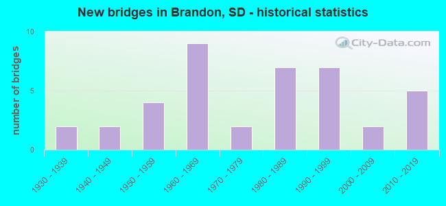
- New bridges - historical statistics
- 21930-1939
- 21940-1949
- 41950-1959
- 91960-1969
- 21970-1979
- 71980-1989
- 71990-1999
- 22000-2009
- 52010-2019


- Bridge Condition - Deck
- 2.9%Very good
- 38.2%Good
- 32.4%Satisfactory
- 20.6%Fair
- 5.9%Poor

- Bridge Condition - Superstructure
- 17.6%Very good
- 35.3%Good
- 29.4%Satisfactory
- 14.7%Fair
- 2.9%Serious

- Bridge Condition - Substructure
- 5.9%Very good
- 38.2%Good
- 44.1%Satisfactory
- 5.9%Fair
- 5.9%Poor

- Bridge Condition - Channel
- 12.1%Very good
- 21.2%Good
- 48.5%Satisfactory
- 18.2%Fair

- Bridge Condition - Culverts
- 75.0%Good
- 25.0%Poor
Find on map >> Show street view
Structure Number: 5026519, Location: 1.5S & 1.5W BRANDON (Lat: 43.572669, Lng: -96.600081), Route carried "on" structure: County highway , Year Built: 1979, Status: Open, Structure Length: 8.45m (27.72ft), Average Daily Traffic: 152 (year 2020), Truck Traffic: 2%, Average Future Daily Traffic: 500 (year 2035), Design Load: HS 20, Features Intersected: BIG SIOUX RIVER, Facility Carried by Structure: 263RD ST, MAPLE ST
Minimum Vertical Clearance: 30+ m (98+ ft), Kilometerpoint: 0.000, Lanes on structure: 2, Owner: County Highway Agency, Approaching Roadway Width: 7.3m (24.0ft), Skew: 1 degrees, Material/Design: Steel continuous, Design/Construction: Stringer/Multi-beam, Number Of Spans In Main Unit: 3, Length of Maximum Span: 38.1m (125.0ft), Curb-To-Curb Width: 9.8m (32.2ft), Out-to-Out Width: 10.6m (34.8ft)
Condition: Deck: Satisfactory, Superstructure: Good, Substructure: Good, Channel: Satisfactory, Operating Rating: 53.3 metric tons, Method Used To Determine Operating Rating: Load Factor (LF), Inventory Rating: 31.9 metric tons, Method Used To Determine Inventory Rating: Load Factor (LF), Structural Evaluation: Better than present minimum criteria, Deck Geometry: Better than present minimum criteria, Waterway Adequacy: Better than present minimum criteria, Approach Roadway Alignment: Equal to present desirable criteria, Length Of Structure Improvement: 9.44m (30.97ft), Designated Inspection Frequency: Every 24 months, Underwater Inspection Frequency: Every 60 months, Inspection Date: June 2020, Underwater Inspection Date: November 2018, Bridge Improvement Cost: $1,456,000, Roadway Improvement Cost: $146,000, Total Project Cost: $2,137,000 ( Estimate for 2018), Deck Structure Type: Concrete Cast-file-Place, Wearing Surface/Protective System: Wearing Surface: Monolithic Concrete
Find on map >> Show street view
Structure Number: 5026612, Location: 4N & 1.4W CORSON (Lat: 43.674089, Lng: -96.599436), Route carried "on" structure: County highway , Year Built: 1999, Status: Open, Structure Length: 0.75m (2.46ft), Average Daily Traffic: 10 (year 2020), Truck Traffic: 2%, Average Future Daily Traffic: 50 (year 2035), Features Intersected: TRIB TO W PIPESTONE CK, Facility Carried by Structure: 256TH STREET
Minimum Vertical Clearance: 30+ m (98+ ft), Kilometerpoint: 0.000, Lanes on structure: 2, Owner: County Highway Agency, Approaching Roadway Width: 6.1m (20.0ft), Material/Design: Concrete continuous, Design/Construction: Culvert, Number Of Spans In Main Unit: 2, Length of Maximum Span: 3.9m (12.8ft)
Condition: Channel: Good, Culverts: Good, Operating Rating: 32.7 metric tons, Method Used To Determine Operating Rating: Field evaluation and documented engineering judgment, Inventory Rating: 19.6 metric tons, Method Used To Determine Inventory Rating: Field evaluation and documented engineering judgment, Structural Evaluation: Somewhat better than minimum adequacy, Waterway Adequacy: Better than present minimum criteria, Approach Roadway Alignment: Equal to present desirable criteria, Length Of Structure Improvement: 1.22m (4.00ft), Designated Inspection Frequency: Every 24 months, Inspection Date: June 2020, Bridge Improvement Cost: $88,000, Roadway Improvement Cost: $9,000, Total Project Cost: $207,000 ( Estimate for 2018)
Find on map >> Show street view
Structure Number: 50266175, Location: 1.4W BRANDON (Lat: 43.594656, Lng: -96.598981), Route carried "on" structure: County highway , Year Built: 1999, Status: Open, Structure Length: 11.95m (39.21ft), Average Daily Traffic: 9,961 (year 2021), Truck Traffic: 3%, Average Future Daily Traffic: 14,000 (year 2036), Design Load: HS 20+Mod, Features Intersected: BIG SIOUX RIVER, Facility Carried by Structure: HOLLY BLVD,HWY 140
Minimum Vertical Clearance: 30+ m (98+ ft), Kilometerpoint: 0.000, Lanes on structure: 2, Owner: County Highway Agency, Approaching Roadway Width: 7.3m (24.0ft), Material/Design: Prestressed concrete, Design/Construction: Stringer/Multi-beam, Number Of Spans In Main Unit: 5, Length of Maximum Span: 24.4m (80.1ft), Curb-To-Curb Width: 16.5m (54.1ft), Out-to-Out Width: 17.3m (56.8ft)
Condition: Deck: Satisfactory, Superstructure: Very good, Substructure: Satisfactory, Channel: Good, Operating Rating: 32.7 metric tons, Method Used To Determine Operating Rating: Field evaluation and documented engineering judgment, Inventory Rating: 24.5 metric tons, Method Used To Determine Inventory Rating: Field evaluation and documented engineering judgment, Structural Evaluation: Equal to present minimum criteria, Deck Geometry: Superior to present desirable criteria, Waterway Adequacy: Equal to present desirable criteria, Approach Roadway Alignment: Superior to present desirable criteria, Length Of Structure Improvement: 12.80m (41.99ft), Designated Inspection Frequency: Every 24 months, Inspection Date: June 2020, Bridge Improvement Cost: $3,500,000, Roadway Improvement Cost: $350,000, Total Project Cost: $5,003,000 ( Estimate for 2018), Deck Structure Type: Concrete Cast-file-Place, Wearing Surface/Protective System: Wearing Surface: Monolithic Concrete
Find on map >> Show street view
Structure Number: 502692, Location: 2.5S & 1.1W BRANDON (Lat: 43.558858, Lng: -96.592344), Route carried "on" structure: County highway , Year Built: 1992, Status: Open, Structure Length: 9.63m (31.59ft), Average Daily Traffic: 4,160 (year 2021), Truck Traffic: 8%, Average Future Daily Traffic: 5,000 (year 2036), Design Load: HS 20+Mod, Features Intersected: BIG SIOUX RIVER, Facility Carried by Structure: 264TH ST, HWY 142
Minimum Vertical Clearance: 30+ m (98+ ft), Kilometerpoint: 0.000, Lanes on structure: 2, Owner: County Highway Agency, Approaching Roadway Width: 7.3m (24.0ft), Material/Design: Prestressed concrete, Design/Construction: Stringer/Multi-beam, Number Of Spans In Main Unit: 4, Length of Maximum Span: 25.6m (84.0ft), Curb-To-Curb Width: 12.2m (40.0ft), Out-to-Out Width: 13.0m (42.7ft)
Condition: Deck: Good, Superstructure: Very good, Substructure: Good, Channel: Satisfactory, Operating Rating: 32.7 metric tons, Method Used To Determine Operating Rating: Field evaluation and documented engineering judgment, Inventory Rating: 24.5 metric tons, Method Used To Determine Inventory Rating: Field evaluation and documented engineering judgment, Structural Evaluation: Equal to present minimum criteria, Deck Geometry: Equal to present minimum criteria, Waterway Adequacy: Better than present minimum criteria, Approach Roadway Alignment: Equal to present minimum criteria, Length Of Structure Improvement: 10.58m (34.71ft), Designated Inspection Frequency: Every 24 months, Underwater Inspection Frequency: Every 60 months, Inspection Date: June 2020, Underwater Inspection Date: October 2018, Bridge Improvement Cost: $2,177,000, Roadway Improvement Cost: $218,000, Total Project Cost: $3,141,000 ( Estimate for 2018), Deck Structure Type: Concrete Cast-file-Place, Wearing Surface/Protective System: Wearing Surface: Monolithic Concrete
Find on map >> Show street view
Structure Number: 50270121, Location: 1W & 3.9N CORSON (Lat: 43.672550, Lng: -96.591339), Route carried "on" structure: County highway , Year Built: 2008, Status: Open, Structure Length: 0.87m (2.85ft), Average Daily Traffic: 24 (year 2020), Truck Traffic: 2%, Average Future Daily Traffic: 50 (year 2035), Features Intersected: TRIB TO W PIPESTONE CK, Facility Carried by Structure: 481ST AVENUE
Minimum Vertical Clearance: 30+ m (98+ ft), Kilometerpoint: 0.000, Lanes on structure: 2, Owner: County Highway Agency, Approaching Roadway Width: 6.1m (20.0ft), Material/Design: Concrete continuous, Design/Construction: Culvert, Number Of Spans In Main Unit: 2, Length of Maximum Span: 4.5m (14.8ft)
Condition: Channel: Very good, Culverts: Good, Operating Rating: 32.7 metric tons, Method Used To Determine Operating Rating: Field evaluation and documented engineering judgment, Inventory Rating: 19.6 metric tons, Method Used To Determine Inventory Rating: Field evaluation and documented engineering judgment, Structural Evaluation: Somewhat better than minimum adequacy, Waterway Adequacy: Better than present minimum criteria, Approach Roadway Alignment: Equal to present desirable criteria, Length Of Structure Improvement: 1.69m (5.54ft), Designated Inspection Frequency: Every 24 months, Inspection Date: June 2020, Bridge Improvement Cost: $88,000, Roadway Improvement Cost: $9,000, Total Project Cost: $213,000 ( Estimate for 2018)
Find on map >> Show street view
Structure Number: 50270205, Location: 0.2W & 3S BRANDON (Lat: 43.550997, Lng: -96.591111), Route carried "on" structure: State highway 11, Year Built: 1963, Status: Open, Structure Length: 12.03m (39.47ft), Average Daily Traffic: 3,815 (year 2021), Truck Traffic: 9%, Average Future Daily Traffic: 5,909 (year 2041), Design Load: HS 20, Features Intersected: SPLIT ROCK CK
Minimum Vertical Clearance: 30+ m (98+ ft), Kilometerpoint: 123.244, Lanes on structure: 2, Base Highway Network: Yes, Owner: State Highway Agency, Approaching Roadway Width: 9.8m (32.2ft), Skew: 3 degrees, Material/Design: Steel continuous, Design/Construction: Stringer/Multi-beam, Number Of Spans In Main Unit: 6, Length of Maximum Span: 21.3m (69.9ft), Curb-To-Curb Width: 9.1m (29.9ft), Out-to-Out Width: 9.9m (32.5ft)
Condition: Deck: Satisfactory, Superstructure: Fair, Substructure: Satisfactory, Channel: Satisfactory, Operating Rating: 50.7 metric tons, Method Used To Determine Operating Rating: Load Factor (LF), Inventory Rating: 30.3 metric tons, Method Used To Determine Inventory Rating: Load Factor (LF), Structural Evaluation: Somewhat better than minimum adequacy, Deck Geometry: Meets minimum limits, Waterway Adequacy: Equal to present desirable criteria, Approach Roadway Alignment: Equal to present desirable criteria, Designated Inspection Frequency: Every 24 months, Underwater Inspection Frequency: Every 60 months, Inspection Date: October 2020, Underwater Inspection Date: October 2018, Deck Structure Type: Concrete Cast-file-Place, Wearing Surface/Protective System: Wearing Surface: Low Slump Concrete, Membrane: Epoxy
Find on map >> Show street view
Structure Number: 502712, Location: 2.5S & 0.9W BRANDON (Lat: 43.558214, Lng: -96.587419), Route carried "on" structure: County highway , Year Built: 1992, Status: Open, Structure Length: 5.90m (19.36ft), Average Daily Traffic: 135 (year 2020), Truck Traffic: 2%, Average Future Daily Traffic: 150 (year 2035), Design Load: HS 20+Mod, Features Intersected: SPLIT ROCK CREEK, Facility Carried by Structure: 264TH STREET
Minimum Vertical Clearance: 30+ m (98+ ft), Kilometerpoint: 0.000, Lanes on structure: 2, Owner: County Highway Agency, Approaching Roadway Width: 6.1m (20.0ft), Material/Design: Concrete continuous, Design/Construction: Slab, Number Of Spans In Main Unit: 5, Length of Maximum Span: 12.7m (41.7ft), Curb-To-Curb Width: 9.8m (32.2ft), Out-to-Out Width: 10.6m (34.8ft)
Condition: Deck: Good, Superstructure: Good, Substructure: Good, Channel: Satisfactory, Operating Rating: 65.6 metric tons, Method Used To Determine Operating Rating: Load Factor (LF), Inventory Rating: 39.3 metric tons, Method Used To Determine Inventory Rating: Load Factor (LF), Structural Evaluation: Better than present minimum criteria, Deck Geometry: Better than present minimum criteria, Waterway Adequacy: Equal to present desirable criteria, Approach Roadway Alignment: Equal to present minimum criteria, Length Of Structure Improvement: 6.94m (22.77ft), Designated Inspection Frequency: Every 24 months, Inspection Date: June 2020, Bridge Improvement Cost: $1,071,000, Roadway Improvement Cost: $107,000, Total Project Cost: $1,590,000 ( Estimate for 2018), Deck Structure Type: Concrete Cast-file-Place, Wearing Surface/Protective System: Wearing Surface: Monolithic Concrete
Find on map >> Show street view
Structure Number: 502742, Location: 2.5S & 0.6W BRANDON (Lat: 43.558717, Lng: -96.581394), Route carried "on" structure: County highway , Year Built: 1992, Status: Open, Structure Length: 2.04m (6.69ft), Average Daily Traffic: 126 (year 2020), Truck Traffic: 2%, Average Future Daily Traffic: 150 (year 2035), Features Intersected: BEAVER CREEK, Facility Carried by Structure: 264TH STREET
Minimum Vertical Clearance: 30+ m (98+ ft), Kilometerpoint: 0.000, Lanes on structure: 2, Owner: County Highway Agency, Approaching Roadway Width: 6.7m (22.0ft), Material/Design: Prestressed concrete, Design/Construction: Tee Beam, Number Of Spans In Main Unit: 1, Length of Maximum Span: 19.8m (65.0ft), Curb-To-Curb Width: 9.7m (31.8ft), Out-to-Out Width: 9.8m (32.2ft)
Condition: Deck: Satisfactory, Superstructure: Good, Substructure: Good, Channel: Fair, Operating Rating: 32.7 metric tons, Method Used To Determine Operating Rating: Field evaluation and documented engineering judgment, Inventory Rating: 24.5 metric tons, Method Used To Determine Inventory Rating: Field evaluation and documented engineering judgment, Structural Evaluation: Equal to present minimum criteria, Deck Geometry: Equal to present minimum criteria, Waterway Adequacy: Equal to present minimum criteria, Approach Roadway Alignment: Better than present minimum criteria, Length Of Structure Improvement: 2.80m (9.19ft), Designated Inspection Frequency: Every 24 months, Inspection Date: June 2020, Bridge Improvement Cost: $432,000, Roadway Improvement Cost: $43,000, Total Project Cost: $686,000 ( Estimate for 2018), Deck Structure Type: Concrete Precast Panels, Wearing Surface/Protective System: Wearing Surface: Monolithic Concrete
Find on map >> Show street view
Structure Number: 50275165, Location: 0.5 W SD 11 INTERCH (Lat: 43.609067, Lng: -96.580564), Route carried "on" structure: Interstate 90, Year Built: 1960, Status: Open, Structure Length: 5.61m (18.41ft), Average Daily Traffic: 13,710 (year 2021), Truck Traffic: 18%, Average Future Daily Traffic: 20,634 (year 2041), Design Load: HS 20+Mod, Features Intersected: BURLINGTON NORTHERN RR
Minimum Vertical Clearance: 30+ m (98+ ft), Kilometerpoint: 653.587, Lanes on structure: 2, Base Highway Network: Yes, Owner: State Highway Agency, Approaching Roadway Width: 12.2m (40.0ft), Material/Design: Concrete continuous, Design/Construction: Slab, Number Of Spans In Main Unit: 3, Length of Maximum Span: 19.5m (64.0ft), Curb-To-Curb Width: 9.1m (29.9ft), Out-to-Out Width: 10.5m (34.4ft)
Condition: Deck: Fair, Superstructure: Fair, Substructure: Fair, Operating Rating: 55.1 metric tons, Method Used To Determine Operating Rating: Load Factor (LF), Inventory Rating: 33.2 metric tons, Method Used To Determine Inventory Rating: Load Factor (LF), Structural Evaluation: Somewhat better than minimum adequacy, Deck Geometry: High priority of replacement, Underclear: Equal to present minimum criteria, Approach Roadway Alignment: Equal to present desirable criteria, Length Of Structure Improvement: 5.64m (18.50ft), Designated Inspection Frequency: Every 24 months, Other Special Inspection Frequency: Every 12 months, Inspection Date: July 2021, Other Special Inspection Date: July 2021, Bridge Improvement Cost: $500,000, Roadway Improvement Cost: $50,000, Total Project Cost: $710,000, Deck Structure Type: Concrete Cast-file-Place, Wearing Surface/Protective System: Wearing Surface: Epoxy Overlay, Membrane: Epoxy
Find on map >> Show street view
Structure Number: 50275166, Location: 0.5 W SD 11 INTERCH (Lat: 43.608844, Lng: -96.580767), Route carried "on" structure: Interstate 90, Year Built: 1960, Status: Open, Structure Length: 5.61m (18.41ft), Average Daily Traffic: 13,710 (year 2021), Truck Traffic: 18%, Average Future Daily Traffic: 20,634 (year 2041), Design Load: HS 20+Mod, Features Intersected: BURLINGTON NORTHERN RR
Minimum Vertical Clearance: 30+ m (98+ ft), Kilometerpoint: 653.587, Lanes on structure: 2, Base Highway Network: Yes, Owner: State Highway Agency, Approaching Roadway Width: 12.2m (40.0ft), Material/Design: Concrete continuous, Design/Construction: Slab, Number Of Spans In Main Unit: 3, Length of Maximum Span: 19.5m (64.0ft), Curb-To-Curb Width: 9.1m (29.9ft), Out-to-Out Width: 10.5m (34.4ft)
Condition: Deck: Satisfactory, Superstructure: Satisfactory, Substructure: Fair, Operating Rating: 65.7 metric tons, Method Used To Determine Operating Rating: Load Factor (LF), Inventory Rating: 39.6 metric tons, Method Used To Determine Inventory Rating: Load Factor (LF), Structural Evaluation: Somewhat better than minimum adequacy, Deck Geometry: High priority of replacement, Underclear: Better than present minimum criteria, Approach Roadway Alignment: Equal to present desirable criteria, Length Of Structure Improvement: 5.64m (18.50ft), Designated Inspection Frequency: Every 24 months, Other Special Inspection Frequency: Every 12 months, Inspection Date: July 2021, Other Special Inspection Date: July 2021, Bridge Improvement Cost: $500,000, Roadway Improvement Cost: $50,000, Total Project Cost: $710,000, Deck Structure Type: Concrete Cast-file-Place, Wearing Surface/Protective System: Wearing Surface: Epoxy Overlay, Membrane: Epoxy
Find on map >> Show street view
Structure Number: 5027612, Location: 4N & 0.4W CORSON (Lat: 43.673964, Lng: -96.578800), Route carried "on" structure: County highway , Year Built: 1940, Status: Posted for load, Structure Length: 2.74m (8.99ft), Average Daily Traffic: 32 (year 2020), Truck Traffic: 2%, Average Future Daily Traffic: 50 (year 2035), Features Intersected: WEST PIPESTONE CREEK, Facility Carried by Structure: 256TH STREET
Minimum Vertical Clearance: 30+ m (98+ ft), Kilometerpoint: 0.000, Lanes on structure: 2, Owner: County Highway Agency, Approaching Roadway Width: 6.1m (20.0ft), Material/Design: Steel, Design/Construction: Stringer/Multi-beam, Number Of Spans In Main Unit: 3, Length of Maximum Span: 9.1m (29.9ft), Curb-To-Curb Width: 5.5m (18.0ft), Out-to-Out Width: 5.9m (19.4ft)
Condition: Deck: Fair, Superstructure: Fair, Substructure: Satisfactory, Channel: Satisfactory, Operating Rating: 44.3 metric tons, Method Used To Determine Operating Rating: Load Factor (LF), Inventory Rating: 26.5 metric tons, Method Used To Determine Inventory Rating: Load Factor (LF), Structural Evaluation: Somewhat better than minimum adequacy, Deck Geometry: Meets minimum limits, Waterway Adequacy: Equal to present minimum criteria, Approach Roadway Alignment: Meets minimum limits, Bridge Posting: Required (Relationship of Operating Rating to Maximum Legal Load: 0.1 - 9.9% below), Length Of Structure Improvement: 3.66m (12.01ft), Designated Inspection Frequency: Every 24 months, Inspection Date: June 2020, Bridge Improvement Cost: $564,000, Roadway Improvement Cost: $56,000, Total Project Cost: $854,000 ( Estimate for 2018), Deck Structure Type: Concrete Cast-file-Place, Wearing Surface/Protective System: Wearing Surface: Monolithic Concrete
Find on map >> Show street view
Structure Number: 5027715, Location: 0.3W & 1N CORSON (Lat: 43.630997, Lng: -96.580122), Route carried "on" structure: County highway , Year Built: 1981, Status: Open, Structure Length: 7.26m (23.82ft), Average Daily Traffic: 72 (year 2020), Truck Traffic: 2%, Average Future Daily Traffic: 125 (year 2035), Design Load: HS 20, Features Intersected: SPLIT ROCK CREEK, Facility Carried by Structure: 259TH STREET
Minimum Vertical Clearance: 30+ m (98+ ft), Kilometerpoint: 0.000, Lanes on structure: 2, Owner: County Highway Agency, Approaching Roadway Width: 7.3m (24.0ft), Skew: 3 degrees, Material/Design: Steel continuous, Design/Construction: Stringer/Multi-beam, Number Of Spans In Main Unit: 2, Length of Maximum Span: 36.0m (118.1ft), Curb-To-Curb Width: 9.8m (32.2ft), Out-to-Out Width: 10.6m (34.8ft)
Condition: Deck: Good, Superstructure: Satisfactory, Substructure: Satisfactory, Channel: Fair, Operating Rating: 73.3 metric tons, Method Used To Determine Operating Rating: Load Factor (LF), Inventory Rating: 43.9 metric tons, Method Used To Determine Inventory Rating: Load Factor (LF), Structural Evaluation: Equal to present minimum criteria, Deck Geometry: Equal to present desirable criteria, Waterway Adequacy: Equal to present minimum criteria, Approach Roadway Alignment: Equal to present desirable criteria, Length Of Structure Improvement: 8.29m (27.20ft), Designated Inspection Frequency: Every 24 months, Underwater Inspection Frequency: Every 60 months, Inspection Date: June 2020, Underwater Inspection Date: October 2018, Bridge Improvement Cost: $1,279,000, Roadway Improvement Cost: $128,000, Total Project Cost: $1,885,000 ( Estimate for 2018), Deck Structure Type: Concrete Cast-file-Place, Wearing Surface/Protective System: Wearing Surface: Monolithic Concrete
Find on map >> Show street view
Structure Number: 50277182, Location: 0.5 S JCT SD 264 (Lat: 43.582686, Lng: -96.577544), Route carried "on" structure: State highway 11, Year Built: 1989, Status: Open, Structure Length: 1.17m (3.84ft), Average Daily Traffic: 6,701 (year 2021), Truck Traffic: 5%, Average Future Daily Traffic: 10,936 (year 2041), Design Load: HS 20+Mod, Features Intersected: ELLIS & EASTERN RR
Minimum Vertical Clearance: 30+ m (98+ ft), Kilometerpoint: 127.170, Lanes on structure: 2, Base Highway Network: Yes, Owner: State Highway Agency, Approaching Roadway Width: 16.5m (54.1ft), Skew: 1 degrees, Material/Design: Steel, Design/Construction: Culvert, Number Of Spans In Main Unit: 1, Length of Maximum Span: 11.7m (38.4ft)
Condition: Culverts: Good, Operating Rating: 44.1 metric tons, Method Used To Determine Operating Rating: Load and Resistance Factor (LRFR), Inventory Rating: 33.9 metric tons, Method Used To Determine Inventory Rating: Load and Resistance Factor (LRFR), Structural Evaluation: Better than present minimum criteria, Underclear: Equal to present minimum criteria, Approach Roadway Alignment: Equal to present desirable criteria, Designated Inspection Frequency: Every 24 months, Inspection Date: April 2021
Find on map >> Show street view
Structure Number: 5027813, Location: 3N & 0.2W CORSON (Lat: 43.659669, Lng: -96.574764), Route carried "on" structure: County highway , Year Built: 1940, Status: Posted for load, Structure Length: 1.83m (6.00ft), Average Daily Traffic: 28 (year 2020), Truck Traffic: 2%, Average Future Daily Traffic: 100 (year 2035), Features Intersected: WEST PIPESTONE CREEK, Facility Carried by Structure: 257TH STREET
Minimum Vertical Clearance: 30+ m (98+ ft), Kilometerpoint: 0.000, Lanes on structure: 2, Owner: County Highway Agency, Approaching Roadway Width: 6.1m (20.0ft), Material/Design: Steel, Design/Construction: Stringer/Multi-beam, Number Of Spans In Main Unit: 2, Length of Maximum Span: 9.0m (29.5ft), Curb-To-Curb Width: 6.1m (20.0ft), Out-to-Out Width: 6.9m (22.6ft)
Condition: Deck: Satisfactory, Superstructure: Satisfactory, Substructure: Poor, Channel: Fair, Operating Rating: 45.2 metric tons, Method Used To Determine Operating Rating: Load Factor (LF), Inventory Rating: 27.0 metric tons, Method Used To Determine Inventory Rating: Load Factor (LF), Structural Evaluation: Meets minimum limits, Deck Geometry: Somewhat better than minimum adequacy, Waterway Adequacy: Equal to present minimum criteria, Approach Roadway Alignment: Better than present minimum criteria, Bridge Posting: Required (Relationship of Operating Rating to Maximum Legal Load: 0.1 - 9.9% below), Length Of Structure Improvement: 2.55m (8.37ft), Designated Inspection Frequency: Every 24 months, Inspection Date: June 2020, Bridge Improvement Cost: $392,000, Roadway Improvement Cost: $39,000, Total Project Cost: $622,000 ( Estimate for 2018), Deck Structure Type: Concrete Cast-file-Place, Wearing Surface/Protective System: Wearing Surface: Monolithic Concrete
Find on map >> Show street view
Structure Number: 5027914, Location: 2N & 0.1W CORSON (Lat: 43.645411, Lng: -96.579553), Route carried "on" structure: County highway , Year Built: 1964, Status: Open, Structure Length: 8.71m (28.58ft), Average Daily Traffic: 1,110 (year 2021), Truck Traffic: 3%, Average Future Daily Traffic: 1,750 (year 2036), Design Load: HS 20, Features Intersected: SPLIT ROCK CREEK, Facility Carried by Structure: 258TH ST, HWY 130
Minimum Vertical Clearance: 30+ m (98+ ft), Kilometerpoint: 0.000, Lanes on structure: 2, Owner: County Highway Agency, Approaching Roadway Width: 7.3m (24.0ft), Skew: 4 degrees, Material/Design: Steel continuous, Design/Construction: Stringer/Multi-beam, Number Of Spans In Main Unit: 3, Length of Maximum Span: 33.5m (109.9ft), Curb-To-Curb Width: 9.1m (29.9ft), Out-to-Out Width: 10.0m (32.8ft)
Condition: Deck: Poor, Superstructure: Satisfactory, Substructure: Satisfactory, Channel: Satisfactory, Operating Rating: 44.6 metric tons, Method Used To Determine Operating Rating: Load Factor (LF), Inventory Rating: 26.7 metric tons, Method Used To Determine Inventory Rating: Load Factor (LF), Structural Evaluation: Equal to present minimum criteria, Deck Geometry: Somewhat better than minimum adequacy, Waterway Adequacy: Equal to present desirable criteria, Approach Roadway Alignment: Equal to present desirable criteria, Length Of Structure Improvement: 9.69m (31.79ft), Designated Inspection Frequency: Every 24 months, Underwater Inspection Frequency: Every 60 months, Inspection Date: June 2020, Underwater Inspection Date: October 2018, Bridge Improvement Cost: $1,495,000, Roadway Improvement Cost: $149,000, Total Project Cost: $2,184,000 ( Estimate for 2018), Deck Structure Type: Concrete Cast-file-Place, Wearing Surface/Protective System: Wearing Surface: Low Slump Concrete
Find on map >> Show street view
Structure Number: 50280136, Location: 2.9 N I 90 INTERCH (Lat: 43.651886, Lng: -96.571747), Route carried "on" structure: State highway 11, Year Built: 1953, Status: Open, Structure Length: 5.67m (18.60ft), Average Daily Traffic: 3,950 (year 2021), Truck Traffic: 7%, Average Future Daily Traffic: 6,119 (year 2041), Design Load: H 20, Features Intersected: WEST PIPESTONE CK
Minimum Vertical Clearance: 30+ m (98+ ft), Kilometerpoint: 135.008, Lanes on structure: 2, Base Highway Network: Yes, Owner: State Highway Agency, Approaching Roadway Width: 8.5m (27.9ft), Material/Design: Concrete continuous, Design/Construction: Slab, Number Of Spans In Main Unit: 5, Length of Maximum Span: 11.5m (37.7ft), Curb-To-Curb Width: 9.1m (29.9ft), Out-to-Out Width: 10.5m (34.4ft)
Condition: Deck: Good, Superstructure: Good, Substructure: Satisfactory, Channel: Good, Operating Rating: 57.8 metric tons, Method Used To Determine Operating Rating: Load Factor (LF), Inventory Rating: 34.6 metric tons, Method Used To Determine Inventory Rating: Load Factor (LF), Structural Evaluation: Equal to present minimum criteria, Deck Geometry: Meets minimum limits, Waterway Adequacy: Equal to present minimum criteria, Approach Roadway Alignment: Equal to present desirable criteria, Designated Inspection Frequency: Every 24 months, Inspection Date: July 2020, Deck Structure Type: Concrete Cast-file-Place, Wearing Surface/Protective System: Wearing Surface: Low Slump Concrete
Find on map >> Show street view
Structure Number: 50280139, Location: 2.7 N I 90 INTERCH (Lat: 43.648514, Lng: -96.571744), Route carried "on" structure: State highway 11, Year Built: 1953, Status: Posted for load, Structure Length: 9.59m (31.46ft), Average Daily Traffic: 3,950 (year 2021), Truck Traffic: 7%, Average Future Daily Traffic: 6,119 (year 2041), Design Load: H 20, Features Intersected: SPLIT ROCK CK
Minimum Vertical Clearance: 30+ m (98+ ft), Kilometerpoint: 134.622, Lanes on structure: 2, Base Highway Network: Yes, Owner: State Highway Agency, Approaching Roadway Width: 8.5m (27.9ft), Material/Design: Steel continuous, Design/Construction: Stringer/Multi-beam, Number Of Spans In Main Unit: 5, Length of Maximum Span: 24.2m (79.4ft), Curb-To-Curb Width: 9.1m (29.9ft), Out-to-Out Width: 9.9m (32.5ft)
Condition: Deck: Fair, Superstructure: Fair, Substructure: Satisfactory, Channel: Fair, Operating Rating: 32.2 metric tons, Method Used To Determine Operating Rating: Load Factor (LF), Inventory Rating: 19.3 metric tons, Method Used To Determine Inventory Rating: Load Factor (LF), Structural Evaluation: Somewhat better than minimum adequacy, Deck Geometry: Meets minimum limits, Waterway Adequacy: Somewhat better than minimum adequacy, Approach Roadway Alignment: Equal to present desirable criteria, Bridge Posting: Required (Relationship of Operating Rating to Maximum Legal Load: 10.0 - 19.9% below), Designated Inspection Frequency: Every 24 months, Inspection Date: October 2020, Deck Structure Type: Concrete Cast-file-Place, Wearing Surface/Protective System: Wearing Surface: Bituminous, Membrane: Preformed Fabric
Find on map >> Show street view
Structure Number: 50280152, Location: 1.2 N I 90 INTERCH (Lat: 43.628003, Lng: -96.571714), Route carried "on" structure: State highway 11, Year Built: 2004, Status: Open, Structure Length: 9.97m (32.71ft), Average Daily Traffic: 3,950 (year 2021), Truck Traffic: 7%, Average Future Daily Traffic: 6,119 (year 2041), Design Load: HS 25 or greater, Features Intersected: SPLIT ROCK CK
Minimum Vertical Clearance: 30+ m (98+ ft), Kilometerpoint: 132.320, Lanes on structure: 2, Base Highway Network: Yes, Owner: State Highway Agency, Approaching Roadway Width: 13.4m (44.0ft), Material/Design: Prestressed concrete continuous, Design/Construction: Stringer/Multi-beam, Number Of Spans In Main Unit: 3, Length of Maximum Span: 34.0m (111.5ft), Curb-To-Curb Width: 12.2m (40.0ft), Out-to-Out Width: 13.0m (42.7ft)
Condition: Deck: Good, Superstructure: Good, Substructure: Satisfactory, Channel: Satisfactory, Operating Rating: 68.7 metric tons, Method Used To Determine Operating Rating: Load Factor (LF), Inventory Rating: 41.1 metric tons, Method Used To Determine Inventory Rating: Load Factor (LF), Structural Evaluation: Equal to present minimum criteria, Deck Geometry: Equal to present minimum criteria, Waterway Adequacy: Superior to present desirable criteria, Approach Roadway Alignment: Superior to present desirable criteria, Designated Inspection Frequency: Every 24 months, Underwater Inspection Frequency: Every 60 months, Inspection Date: September 2020, Underwater Inspection Date: October 2018, Deck Structure Type: Concrete Cast-file-Place, Wearing Surface/Protective System: Wearing Surface: Integral Concrete, Deck Protection: Epoxy Coated Reinforcing
Find on map >> Show street view
Structure Number: 50280165, Location: SD 11 & I 90 INTERCHANGE (Lat: 43.608894, Lng: -96.572175), Route carried "on" structure: State highway 11, Year Built: 1960, Status: Open, Structure Length: 7.74m (25.39ft), Average Daily Traffic: 6,978 (year 2021), Truck Traffic: 10%, Average Future Daily Traffic: 10,809 (year 2041), Design Load: HS 20, Features Intersected: I090
Minimum Vertical Clearance: 30+ m (98+ ft), Kilometerpoint: 130.180, Lanes on structure: 2, Lanes under structure: 4, Base Highway Network: Yes, Owner: State Highway Agency, Approaching Roadway Width: 8.5m (27.9ft), Material/Design: Concrete continuous, Design/Construction: Slab, Number Of Spans In Main Unit: 4, Length of Maximum Span: 19.5m (64.0ft), Curb-To-Curb Width: 9.1m (29.9ft), Out-to-Out Width: 10.5m (34.4ft)
Condition: Deck: Satisfactory, Superstructure: Satisfactory, Substructure: Satisfactory, Operating Rating: 65.0 metric tons, Method Used To Determine Operating Rating: Load Factor (LF), Inventory Rating: 39.3 metric tons, Method Used To Determine Inventory Rating: Load Factor (LF), Structural Evaluation: Equal to present minimum criteria, Deck Geometry: Meets minimum limits, Underclear: Equal to present minimum criteria, Approach Roadway Alignment: Equal to present minimum criteria, Designated Inspection Frequency: Every 24 months, Other Special Inspection Frequency: Every 12 months, Inspection Date: July 2021, Other Special Inspection Date: July 2021, Deck Structure Type: Concrete Cast-file-Place, Wearing Surface/Protective System: Wearing Surface: Low Slump Concrete
Find on map >> Show street view
Structure Number: 5028118, Location: 0.1E & 0.5S BRANDON (Lat: 43.585953, Lng: -96.566889), Route carried "on" structure: City street , Year Built: 1986, Status: Open, Structure Length: 5.55m (18.21ft), Average Daily Traffic: 60 (year 2019), Truck Traffic: 2%, Average Future Daily Traffic: 60 (year 2032), Design Load: HS 20+Mod, Features Intersected: SPLIT ROCK CREEK, Facility Carried by Structure: MCHARDY ROAD
Minimum Vertical Clearance: 4.85m (15.91ft), Kilometerpoint: 0.000, Lanes on structure: 2, Owner: Town or Township Highway Agency, Approaching Roadway Width: 7.3m (24.0ft), Material/Design: Steel continuous, Design/Construction: Stringer/Multi-beam, Number Of Spans In Main Unit: 3, Length of Maximum Span: 20.7m (67.9ft), Curb-To-Curb Width: 9.8m (32.2ft), Out-to-Out Width: 10.6m (34.8ft)
Condition: Deck: Fair, Superstructure: Satisfactory, Substructure: Satisfactory, Channel: Good, Operating Rating: 27.7 metric tons, Method Used To Determine Operating Rating: Load and Resistance Factor (LRFR), Inventory Rating: 21.3 metric tons, Method Used To Determine Inventory Rating: Load and Resistance Factor (LRFR), Structural Evaluation: Equal to present minimum criteria, Deck Geometry: Better than present minimum criteria, Waterway Adequacy: Better than present minimum criteria, Approach Roadway Alignment: Better than present minimum criteria, Designated Inspection Frequency: Every 24 months, Inspection Date: August 2020, Deck Structure Type: Concrete Cast-file-Place, Wearing Surface/Protective System: Wearing Surface: Monolithic Concrete
Find on map >> Show street view
Structure Number: 5028416, Location: 0.4E CORSON (Lat: 43.616308, Lng: -96.564858), Route carried "on" structure: County highway , Year Built: 1964, Status: Open, Structure Length: 7.65m (25.10ft), Average Daily Traffic: 60 (year 2020), Truck Traffic: 2%, Average Future Daily Traffic: 100 (year 2035), Design Load: H 20, Features Intersected: SPLIT ROCK CREEK, Facility Carried by Structure: 260TH STREET
Minimum Vertical Clearance: 30+ m (98+ ft), Kilometerpoint: 0.000, Lanes on structure: 2, Owner: County Highway Agency, Approaching Roadway Width: 7.3m (24.0ft), Material/Design: Steel continuous, Design/Construction: Stringer/Multi-beam, Number Of Spans In Main Unit: 3, Length of Maximum Span: 29.0m (95.1ft), Curb-To-Curb Width: 9.1m (29.9ft), Out-to-Out Width: 10.0m (32.8ft)
Condition: Deck: Satisfactory, Superstructure: Satisfactory, Substructure: Satisfactory, Channel: Satisfactory, Operating Rating: 60.5 metric tons, Method Used To Determine Operating Rating: Load Factor (LF), Inventory Rating: 36.2 metric tons, Method Used To Determine Inventory Rating: Load Factor (LF), Structural Evaluation: Equal to present minimum criteria, Deck Geometry: Better than present minimum criteria, Waterway Adequacy: Better than present minimum criteria, Approach Roadway Alignment: Better than present minimum criteria, Length Of Structure Improvement: 8.67m (28.44ft), Designated Inspection Frequency: Every 24 months, Underwater Inspection Frequency: Every 60 months, Inspection Date: June 2020, Underwater Inspection Date: October 2018, Bridge Improvement Cost: $1,337,000, Roadway Improvement Cost: $134,000, Total Project Cost: $1,960,000 ( Estimate for 2018), Deck Structure Type: Concrete Cast-file-Place, Wearing Surface/Protective System: Wearing Surface: Monolithic Concrete
Find on map >> Show street view
Structure Number: 50284165, Location: 0.4 E SD 11 INTERCH (Lat: 43.608644, Lng: -96.563069), Route carried "on" structure: Interstate 90, Year Built: 2018, Status: Open, Structure Length: 11.54m (37.86ft), Average Daily Traffic: 10,730 (year 2021), Truck Traffic: 21%, Average Future Daily Traffic: 16,910 (year 2041), Design Load: HL 93, Features Intersected: SPLIT ROCK CK
Minimum Vertical Clearance: 30+ m (98+ ft), Kilometerpoint: 655.003, Lanes on structure: 2, Base Highway Network: Yes, Owner: State Highway Agency, Approaching Roadway Width: 12.2m (40.0ft), Skew: 3 degrees, Material/Design: Prestressed concrete, Design/Construction: Stringer/Multi-beam, Number Of Spans In Main Unit: 4, Length of Maximum Span: 29.9m (98.1ft), Curb-To-Curb Width: 12.2m (40.0ft), Out-to-Out Width: 13.0m (42.7ft)
Condition: Deck: Good, Superstructure: Very good, Substructure: Good, Channel: Very good, Operating Rating: 65.0 metric tons, Method Used To Determine Operating Rating: Load and Resistance Factor (LRFR), Inventory Rating: 36.3 metric tons, Method Used To Determine Inventory Rating: Load and Resistance Factor (LRFR), Structural Evaluation: Better than present minimum criteria, Deck Geometry: Better than present minimum criteria, Waterway Adequacy: Superior to present desirable criteria, Approach Roadway Alignment: Superior to present desirable criteria, Designated Inspection Frequency: Every 24 months, Inspection Date: September 2021, Deck Structure Type: Concrete Cast-file-Place, Wearing Surface/Protective System: Wearing Surface: Integral Concrete, Deck Protection: Epoxy Coated Reinforcing
Find on map >> Show street view
Structure Number: 50284166, Location: 0.4 E SD 11 INTERCH (Lat: 43.608389, Lng: -96.562931), Route carried "on" structure: Interstate 90, Year Built: 2017, Status: Open, Structure Length: 11.54m (37.86ft), Average Daily Traffic: 10,730 (year 2021), Truck Traffic: 21%, Average Future Daily Traffic: 16,910 (year 2041), Design Load: HL 93, Features Intersected: SPLIT ROCK CK
Minimum Vertical Clearance: 30+ m (98+ ft), Kilometerpoint: 655.003, Lanes on structure: 2, Base Highway Network: Yes, Owner: State Highway Agency, Approaching Roadway Width: 12.2m (40.0ft), Skew: 3 degrees, Material/Design: Prestressed concrete, Design/Construction: Stringer/Multi-beam, Number Of Spans In Main Unit: 4, Length of Maximum Span: 29.9m (98.1ft), Curb-To-Curb Width: 15.2m (49.9ft), Out-to-Out Width: 16.1m (52.8ft)
Condition: Deck: Good, Superstructure: Good, Substructure: Good, Channel: Very good, Operating Rating: 65.0 metric tons, Method Used To Determine Operating Rating: Load and Resistance Factor (LRFR), Inventory Rating: 36.3 metric tons, Method Used To Determine Inventory Rating: Load and Resistance Factor (LRFR), Structural Evaluation: Better than present minimum criteria, Deck Geometry: Superior to present desirable criteria, Waterway Adequacy: Superior to present desirable criteria, Approach Roadway Alignment: Superior to present desirable criteria, Designated Inspection Frequency: Every 24 months, Inspection Date: September 2021, Deck Structure Type: Concrete Cast-file-Place, Wearing Surface/Protective System: Wearing Surface: Integral Concrete, Deck Protection: Epoxy Coated Reinforcing
Find on map >> Show street view
Structure Number: 5028417, Location: 0.4E & 0.5N BRANDON (Lat: 43.601819, Lng: -96.561950), Route carried "on" structure: County highway , Year Built: 2016, Status: Open, Structure Length: 9.20m (30.18ft), Average Daily Traffic: 398 (year 2020), Truck Traffic: 2%, Average Future Daily Traffic: 500 (year 2035), Design Load: HL 93, Features Intersected: SPLIT ROCK CREEK, Facility Carried by Structure: 261ST STREET
Minimum Vertical Clearance: 30+ m (98+ ft), Kilometerpoint: 0.000, Lanes on structure: 2, Owner: County Highway Agency, Approaching Roadway Width: 9.1m (29.9ft), Material/Design: Prestressed concrete, Design/Construction: Stringer/Multi-beam, Number Of Spans In Main Unit: 4, Length of Maximum Span: 22.9m (75.1ft), Curb or Sidewalk Widths: Left: 0.0m, Right: 2.4m (7.9ft), Curb-To-Curb Width: 9.1m (29.9ft), Out-to-Out Width: 12.5m (41.0ft)
Condition: Deck: Good, Superstructure: Very good, Substructure: Very good, Channel: Satisfactory, Operating Rating: 51.2 metric tons, Method Used To Determine Operating Rating: Load and Resistance Factor (LRFR), Inventory Rating: 39.5 metric tons, Method Used To Determine Inventory Rating: Load and Resistance Factor (LRFR), Structural Evaluation: Equal to present desirable criteria, Deck Geometry: Equal to present minimum criteria, Waterway Adequacy: Equal to present desirable criteria, Approach Roadway Alignment: Better than present minimum criteria, Length Of Structure Improvement: 10.17m (33.37ft), Designated Inspection Frequency: Every 24 months, Inspection Date: June 2020, Bridge Improvement Cost: $2,005,000, Roadway Improvement Cost: $200,000, Total Project Cost: $2,898,000 ( Estimate for 2018), Deck Structure Type: Concrete Cast-file-Place, Wearing Surface/Protective System: Wearing Surface: Monolithic Concrete
Find on map >> Show street view
Structure Number: 5028618, Location: 0.6E & 0.5S BRANDON (Lat: 43.587108, Lng: -96.561539), Route carried "on" structure: County highway , Year Built: 1988, Status: Open, Structure Length: 6.61m (21.69ft), Average Daily Traffic: 5,213 (year 2021), Truck Traffic: 5%, Average Future Daily Traffic: 5,650 (year 2036), Design Load: HS 20+Mod, Features Intersected: SPLIT ROCK CREEK, Facility Carried by Structure: ASPEN BLVD,HWY 138
Minimum Vertical Clearance: 30+ m (98+ ft), Kilometerpoint: 0.000, Lanes on structure: 2, Owner: County Highway Agency, Approaching Roadway Width: 7.3m (24.0ft), Material/Design: Prestressed concrete, Design/Construction: Stringer/Multi-beam, Number Of Spans In Main Unit: 3, Length of Maximum Span: 22.9m (75.1ft), Curb-To-Curb Width: 12.2m (40.0ft), Out-to-Out Width: 13.0m (42.7ft)
Condition: Deck: Good, Superstructure: Very good, Substructure: Good, Channel: Satisfactory, Operating Rating: 32.7 metric tons, Method Used To Determine Operating Rating: Field evaluation and documented engineering judgment, Inventory Rating: 24.5 metric tons, Method Used To Determine Inventory Rating: Field evaluation and documented engineering judgment, Structural Evaluation: Equal to present minimum criteria, Deck Geometry: Somewhat better than minimum adequacy, Waterway Adequacy: Better than present minimum criteria, Approach Roadway Alignment: Equal to present minimum criteria, Length Of Structure Improvement: 7.65m (25.10ft), Designated Inspection Frequency: Every 24 months, Inspection Date: June 2020, Bridge Improvement Cost: $1,575,000, Roadway Improvement Cost: $158,000, Total Project Cost: $2,289,000 ( Estimate for 2018), Deck Structure Type: Concrete Cast-file-Place, Wearing Surface/Protective System: Wearing Surface: Monolithic Concrete
Find on map >> Show street view
Structure Number: 502862, Location: 0.6E & 2.5S BRANDON (Lat: 43.558536, Lng: -96.558975), Route carried "on" structure: County highway , Year Built: 1989, Status: Open, Structure Length: 3.26m (10.70ft), Average Daily Traffic: 30 (year 2019), Truck Traffic: 2%, Average Future Daily Traffic: 30 (year 2032), Features Intersected: BEAVER CREEK, Facility Carried by Structure: 264TH STREET
Minimum Vertical Clearance: 30+ m (98+ ft), Kilometerpoint: 0.000, Lanes on structure: 2, Owner: County Highway Agency, Approaching Roadway Width: 6.1m (20.0ft), Material/Design: Prestressed concrete, Design/Construction: Stringer/Multi-beam, Number Of Spans In Main Unit: 1, Length of Maximum Span: 32.1m (105.3ft), Curb-To-Curb Width: 9.8m (32.2ft), Out-to-Out Width: 10.9m (35.8ft)
Condition: Deck: Good, Superstructure: Good, Substructure: Good, Channel: Satisfactory, Operating Rating: 32.7 metric tons, Method Used To Determine Operating Rating: Field evaluation and documented engineering judgment, Inventory Rating: 24.5 metric tons, Method Used To Determine Inventory Rating: Field evaluation and documented engineering judgment, Structural Evaluation: Equal to present minimum criteria, Deck Geometry: Equal to present desirable criteria, Waterway Adequacy: Better than present minimum criteria, Approach Roadway Alignment: Somewhat better than minimum adequacy, Length Of Structure Improvement: 4.13m (13.55ft), Designated Inspection Frequency: Every 24 months, Inspection Date: June 2020, Bridge Improvement Cost: $637,000, Roadway Improvement Cost: $64,000, Total Project Cost: $978,000 ( Estimate for 2018), Deck Structure Type: Concrete Cast-file-Place, Wearing Surface/Protective System: Wearing Surface: Monolithic Concrete
Find on map >> Show street view
Structure Number: 50290129, Location: 4.6N & 1E BRANDON (Lat: 43.660894, Lng: -96.551572), Route carried "on" structure: County highway , Year Built: 1994, Status: Open, Structure Length: 7.99m (26.21ft), Average Daily Traffic: 31 (year 2020), Truck Traffic: 2%, Average Future Daily Traffic: 50 (year 2035), Features Intersected: SPLIT ROCK CREEK, Facility Carried by Structure: 257TH STREET
Minimum Vertical Clearance: 30+ m (98+ ft), Kilometerpoint: 0.000, Lanes on structure: 2, Owner: County Highway Agency, Approaching Roadway Width: 6.7m (22.0ft), Skew: 3 degrees, Material/Design: Prestressed concrete, Design/Construction: Stringer/Multi-beam, Number Of Spans In Main Unit: 4, Length of Maximum Span: 21.3m (69.9ft), Curb-To-Curb Width: 9.8m (32.2ft), Out-to-Out Width: 10.6m (34.8ft)
Condition: Deck: Good, Superstructure: Good, Substructure: Good, Channel: Satisfactory, Operating Rating: 32.7 metric tons, Method Used To Determine Operating Rating: Field evaluation and documented engineering judgment, Inventory Rating: 24.5 metric tons, Method Used To Determine Inventory Rating: Field evaluation and documented engineering judgment, Structural Evaluation: Equal to present minimum criteria, Deck Geometry: Equal to present desirable criteria, Waterway Adequacy: Equal to present desirable criteria, Approach Roadway Alignment: Better than present minimum criteria, Length Of Structure Improvement: 9.00m (29.53ft), Designated Inspection Frequency: Every 24 months, Inspection Date: June 2020, Bridge Improvement Cost: $1,389,000, Roadway Improvement Cost: $139,000, Total Project Cost: $2,041,000 ( Estimate for 2018), Deck Structure Type: Concrete Cast-file-Place, Wearing Surface/Protective System: Wearing Surface: Monolithic Concrete
Find on map >> Show street view
Structure Number: 50290131, Location: 2.9N & 1E CORSON (Lat: 43.658550, Lng: -96.551586), Route carried "on" structure: County highway , Year Built: 1937, Status: Posted for load, Structure Length: 1.14m (3.74ft), Average Daily Traffic: 7 (year 2020), Truck Traffic: 2%, Average Future Daily Traffic: 25 (year 2035), Features Intersected: TRIB TO SPLIT ROCK CK, Facility Carried by Structure: 483RD AVENUE
Minimum Vertical Clearance: 30+ m (98+ ft), Kilometerpoint: 0.000, Lanes on structure: 2, Owner: County Highway Agency, Approaching Roadway Width: 6.1m (20.0ft), Material/Design: Steel, Design/Construction: Stringer/Multi-beam, Number Of Spans In Main Unit: 3, Length of Maximum Span: 3.9m (12.8ft), Curb-To-Curb Width: 6.1m (20.0ft), Out-to-Out Width: 6.7m (22.0ft)
Condition: Deck: Poor, Superstructure: Serious, Substructure: Poor, Channel: Fair, Operating Rating: 27.9 metric tons, Method Used To Determine Operating Rating: Load Factor (LF), Inventory Rating: 16.8 metric tons, Method Used To Determine Inventory Rating: Load Factor (LF), Structural Evaluation: High priority of corrective action, Deck Geometry: Somewhat better than minimum adequacy, Waterway Adequacy: High priority of corrective action, Approach Roadway Alignment: Equal to present minimum criteria, Bridge Posting: Required (Relationship of Operating Rating to Maximum Legal Load: > 39.9% below), Length Of Structure Improvement: 1.82m (5.97ft), Designated Inspection Frequency: Every 12 months, Inspection Date: June 2021, Bridge Improvement Cost: $280,000, Roadway Improvement Cost: $28,000, Total Project Cost: $467,000 ( Estimate for 2018), Deck Structure Type: Concrete Cast-file-Place, Wearing Surface/Protective System: Wearing Surface: Monolithic Concrete
Find on map >> Show street view
Structure Number: 50290149, Location: 1.1N & 1E CORSON (Lat: 43.631511, Lng: -96.551914), Route carried "on" structure: County highway , Year Built: 1938, Status: Open, Structure Length: 0.63m (2.07ft), Average Daily Traffic: 15 (year 2020), Truck Traffic: 2%, Average Future Daily Traffic: 25 (year 2035), Features Intersected: TRIB TO SPLIT ROCK CK, Facility Carried by Structure: 483RD AVENUE
Minimum Vertical Clearance: 30+ m (98+ ft), Kilometerpoint: 0.000, Lanes on structure: 2, Owner: County Highway Agency, Approaching Roadway Width: 6.1m (20.0ft), Material/Design: Concrete continuous, Design/Construction: Culvert, Number Of Spans In Main Unit: 2, Length of Maximum Span: 3.3m (10.8ft)
Condition: Channel: Good, Culverts: Poor, Operating Rating: 32.7 metric tons, Method Used To Determine Operating Rating: Field evaluation and documented engineering judgment, Inventory Rating: 19.6 metric tons, Method Used To Determine Inventory Rating: Field evaluation and documented engineering judgment, Structural Evaluation: Meets minimum limits, Waterway Adequacy: Meets minimum limits, Approach Roadway Alignment: Better than present minimum criteria, Length Of Structure Improvement: 1.22m (4.00ft), Designated Inspection Frequency: Every 24 months, Inspection Date: June 2020, Bridge Improvement Cost: $88,000, Roadway Improvement Cost: $9,000, Total Project Cost: $205,000 ( Estimate for 2018), Wearing Surface/Protective System: Wearing Surface: Monolithic Concrete
Find on map >> Show street view
Structure Number: 50290199, Location: 1E & 2.4S BRANDON (Lat: 43.559211, Lng: -96.550417), Route carried "on" structure: County highway , Year Built: 1989, Status: Open, Structure Length: 3.26m (10.70ft), Average Daily Traffic: 42 (year 2020), Truck Traffic: 2%, Average Future Daily Traffic: 50 (year 2035), Features Intersected: BEAVER CREEK, Facility Carried by Structure: 483RD AVENUE
Minimum Vertical Clearance: 30+ m (98+ ft), Kilometerpoint: 0.000, Lanes on structure: 2, Owner: County Highway Agency, Approaching Roadway Width: 6.1m (20.0ft), Material/Design: Prestressed concrete, Design/Construction: Stringer/Multi-beam, Number Of Spans In Main Unit: 1, Length of Maximum Span: 32.1m (105.3ft), Curb-To-Curb Width: 9.8m (32.2ft), Out-to-Out Width: 10.9m (35.8ft)
Condition: Deck: Good, Superstructure: Good, Substructure: Good, Channel: Satisfactory, Operating Rating: 32.7 metric tons, Method Used To Determine Operating Rating: Field evaluation and documented engineering judgment, Inventory Rating: 24.5 metric tons, Method Used To Determine Inventory Rating: Field evaluation and documented engineering judgment, Structural Evaluation: Equal to present minimum criteria, Deck Geometry: Equal to present desirable criteria, Waterway Adequacy: Equal to present minimum criteria, Approach Roadway Alignment: Better than present minimum criteria, Length Of Structure Improvement: 4.13m (13.55ft), Designated Inspection Frequency: Every 24 months, Inspection Date: June 2020, Bridge Improvement Cost: $637,000, Roadway Improvement Cost: $64,000, Total Project Cost: $978,000 ( Estimate for 2018), Deck Structure Type: Concrete Cast-file-Place, Wearing Surface/Protective System: Wearing Surface: Monolithic Concrete
Find on map >> Show street view
Structure Number: 502932, Location: 2S & 3.7W VALLEY SPRINGS (Lat: 43.558331, Lng: -96.544711), Route carried "on" structure: County highway , Year Built: 2018, Status: Open, Structure Length: 3.63m (11.91ft), Average Daily Traffic: 8 (year 2020), Truck Traffic: 2%, Average Future Daily Traffic: 50 (year 2035), Design Load: HL 93, Features Intersected: BEAVER CREEK, Facility Carried by Structure: 264TH STREET
Minimum Vertical Clearance: 30+ m (98+ ft), Kilometerpoint: 0.000, Lanes on structure: 2, Owner: County Highway Agency, Approaching Roadway Width: 8.5m (27.9ft), Material/Design: Prestressed concrete, Design/Construction: Stringer/Multi-beam, Number Of Spans In Main Unit: 2, Length of Maximum Span: 17.8m (58.4ft), Curb-To-Curb Width: 8.5m (27.9ft), Out-to-Out Width: 9.4m (30.8ft)
Condition: Deck: Very good, Superstructure: Very good, Substructure: Very good, Channel: Good, Operating Rating: 48.3 metric tons, Method Used To Determine Operating Rating: Load and Resistance Factor (LRFR), Inventory Rating: 39.1 metric tons, Method Used To Determine Inventory Rating: Load and Resistance Factor (LRFR), Structural Evaluation: Equal to present desirable criteria, Deck Geometry: Better than present minimum criteria, Waterway Adequacy: Equal to present desirable criteria, Approach Roadway Alignment: Equal to present minimum criteria, Designated Inspection Frequency: Every 24 months, Inspection Date: June 2020, Deck Structure Type: Concrete Cast-file-Place, Wearing Surface/Protective System: Wearing Surface: Integral Concrete
Find on map >> Show street view
Structure Number: 502982, Location: 1.8E & 2.5S BRANDON (Lat: 43.558378, Lng: -96.536342), Route carried "on" structure: County highway , Year Built: 2014, Status: Open, Structure Length: 2.93m (9.61ft), Average Daily Traffic: 32 (year 2020), Truck Traffic: 9%, Average Future Daily Traffic: 50 (year 2035), Design Load: HL 93, Features Intersected: BEAVER CREEK, Facility Carried by Structure: 264TH STREET
Minimum Vertical Clearance: 30+ m (98+ ft), Kilometerpoint: 0.000, Lanes on structure: 2, Owner: County Highway Agency, Approaching Roadway Width: 6.7m (22.0ft), Material/Design: Concrete continuous, Design/Construction: Slab, Number Of Spans In Main Unit: 3, Length of Maximum Span: 11.0m (36.1ft), Curb-To-Curb Width: 9.1m (29.9ft), Out-to-Out Width: 9.4m (30.8ft)
Condition: Deck: Good, Superstructure: Good, Substructure: Good, Channel: Satisfactory, Operating Rating: 53.5 metric tons, Method Used To Determine Operating Rating: Load and Resistance Factor (LRFR), Inventory Rating: 41.2 metric tons, Method Used To Determine Inventory Rating: Load and Resistance Factor (LRFR), Structural Evaluation: Better than present minimum criteria, Deck Geometry: Better than present minimum criteria, Waterway Adequacy: Somewhat better than minimum adequacy, Approach Roadway Alignment: Equal to present minimum criteria, Length Of Structure Improvement: 3.83m (12.57ft), Designated Inspection Frequency: Every 24 months, Inspection Date: June 2020, Bridge Improvement Cost: $592,000, Roadway Improvement Cost: $59,000, Total Project Cost: $907,000 ( Estimate for 2018), Deck Structure Type: Concrete Cast-file-Place, Wearing Surface/Protective System: Wearing Surface: Monolithic Concrete
Find on map >> Show street view
Structure Number: 50300166, Location: 2 E SD 11 INTERCH (Lat: 43.608694, Lng: -96.532114), Route carried "on" structure: County highway , Year Built: 1959, Status: Open, Structure Length: 7.74m (25.39ft), Average Daily Traffic: 115 (year 2020), Truck Traffic: 2%, Average Future Daily Traffic: 115 (year 2040), Design Load: HS 20, Features Intersected: I090, Facility Carried by Structure: 484 AVE
Minimum Vertical Clearance: 30+ m (98+ ft), Kilometerpoint: 0.000, Lanes on structure: 2, Lanes under structure: 4, Owner: State Highway Agency, Approaching Roadway Width: 9.1m (29.9ft), Material/Design: Concrete continuous, Design/Construction: Slab, Number Of Spans In Main Unit: 4, Length of Maximum Span: 21.3m (69.9ft), Curb-To-Curb Width: 9.1m (29.9ft), Out-to-Out Width: 10.5m (34.4ft)
Condition: Deck: Satisfactory, Superstructure: Satisfactory, Substructure: Satisfactory, Operating Rating: 45.3 metric tons, Method Used To Determine Operating Rating: Load Factor (LF), Inventory Rating: 27.1 metric tons, Method Used To Determine Inventory Rating: Load Factor (LF), Structural Evaluation: Equal to present minimum criteria, Deck Geometry: Equal to present minimum criteria, Underclear: Equal to present minimum criteria, Approach Roadway Alignment: Equal to present minimum criteria, Designated Inspection Frequency: Every 24 months, Other Special Inspection Frequency: Every 12 months, Inspection Date: July 2021, Other Special Inspection Date: July 2021, Deck Structure Type: Concrete Cast-file-Place, Wearing Surface/Protective System: Wearing Surface: Low Slump Concrete
Find on map >> Show street view
Structure Number: 50300199, Location: 3W & 1.9S VALLEY SPRINGS (Lat: 43.560744, Lng: -96.532128), Route carried "on" structure: County highway , Year Built: 1962, Year Reconstructed: 2006, Status: Open, Structure Length: 3.92m (12.86ft), Average Daily Traffic: 1,116 (year 2021), Truck Traffic: 3%, Average Future Daily Traffic: 1,500 (year 2036), Design Load: H 20, Features Intersected: BEAVER CREEK, Facility Carried by Structure: 484TH AVE, HWY 109
Minimum Vertical Clearance: 30+ m (98+ ft), Kilometerpoint: 0.000, Lanes on structure: 2, Owner: County Highway Agency, Approaching Roadway Width: 7.3m (24.0ft), Material/Design: Concrete continuous, Design/Construction: Slab, Number Of Spans In Main Unit: 5, Length of Maximum Span: 8.4m (27.6ft), Curb-To-Curb Width: 9.1m (29.9ft), Out-to-Out Width: 10.5m (34.4ft)
Condition: Deck: Fair, Superstructure: Satisfactory, Substructure: Good, Channel: Satisfactory, Operating Rating: 34.7 metric tons, Method Used To Determine Operating Rating: Load Factor (LF), Inventory Rating: 20.8 metric tons, Method Used To Determine Inventory Rating: Load Factor (LF), Structural Evaluation: Somewhat better than minimum adequacy, Deck Geometry: Somewhat better than minimum adequacy, Waterway Adequacy: Equal to present minimum criteria, Approach Roadway Alignment: Somewhat better than minimum adequacy, Length Of Structure Improvement: 4.86m (15.94ft), Designated Inspection Frequency: Every 24 months, Inspection Date: June 2020, Bridge Improvement Cost: $750,000, Roadway Improvement Cost: $75,000, Total Project Cost: $1,135,000 ( Estimate for 2018), Deck Structure Type: Concrete Cast-file-Place, Wearing Surface/Protective System: Wearing Surface: Low Slump Concrete
Find on map >> Show street view
Structure Number: 50300203, Location: 3W & 2.3S VALLEY SPRINGS (Lat: 43.551892, Lng: -96.532097), Route carried "on" structure: County highway , Year Built: 1962, Year Reconstructed: 2006, Status: Open, Structure Length: 3.58m (11.75ft), Average Daily Traffic: 1,085 (year 2021), Truck Traffic: 3%, Average Future Daily Traffic: 1,500 (year 2036), Design Load: H 20, Features Intersected: FOUR MILE CREEK, Facility Carried by Structure: 484TH AVE, HWY 109
Minimum Vertical Clearance: 30+ m (98+ ft), Kilometerpoint: 0.000, Lanes on structure: 2, Owner: County Highway Agency, Approaching Roadway Width: 7.3m (24.0ft), Skew: 3 degrees, Material/Design: Concrete continuous, Design/Construction: Slab, Number Of Spans In Main Unit: 5, Length of Maximum Span: 7.6m (24.9ft), Curb-To-Curb Width: 9.1m (29.9ft), Out-to-Out Width: 10.5m (34.4ft)
Condition: Deck: Fair, Superstructure: Satisfactory, Substructure: Satisfactory, Channel: Good, Operating Rating: 41.2 metric tons, Method Used To Determine Operating Rating: Load Factor (LF), Inventory Rating: 24.6 metric tons, Method Used To Determine Inventory Rating: Load Factor (LF), Structural Evaluation: Equal to present minimum criteria, Deck Geometry: Somewhat better than minimum adequacy, Waterway Adequacy: Better than present minimum criteria, Approach Roadway Alignment: Equal to present minimum criteria, Length Of Structure Improvement: 4.49m (14.73ft), Designated Inspection Frequency: Every 24 months, Inspection Date: June 2020, Bridge Improvement Cost: $692,000, Roadway Improvement Cost: $69,000, Total Project Cost: $1,054,000 ( Estimate for 2018), Deck Structure Type: Concrete Cast-file-Place, Wearing Surface/Protective System: Wearing Surface: Low Slump Concrete
Find on map >> Show street view
Structure Number: 5030621, Location: 3S & 2.4W VALLEY SPRINGS (Lat: 43.543853, Lng: -96.518814), Route carried "on" structure: County highway , Year Built: 1983, Status: Open, Structure Length: 2.04m (6.69ft), Average Daily Traffic: 31 (year 2020), Truck Traffic: 2%, Average Future Daily Traffic: 50 (year 2035), Features Intersected: TRIB TO FOUR MILE CK, Facility Carried by Structure: 265TH STREET
Minimum Vertical Clearance: 30+ m (98+ ft), Kilometerpoint: 0.000, Lanes on structure: 2, Owner: County Highway Agency, Approaching Roadway Width: 6.7m (22.0ft), Material/Design: Prestressed concrete, Design/Construction: Tee Beam, Number Of Spans In Main Unit: 1, Length of Maximum Span: 19.8m (65.0ft), Curb-To-Curb Width: 9.7m (31.8ft), Out-to-Out Width: 9.9m (32.5ft)
Condition: Deck: Satisfactory, Superstructure: Good, Substructure: Satisfactory, Channel: Very good, Operating Rating: 32.7 metric tons, Method Used To Determine Operating Rating: Field evaluation and documented engineering judgment, Inventory Rating: 19.6 metric tons, Method Used To Determine Inventory Rating: Field evaluation and documented engineering judgment, Structural Evaluation: Somewhat better than minimum adequacy, Deck Geometry: Better than present minimum criteria, Waterway Adequacy: Equal to present desirable criteria, Approach Roadway Alignment: Equal to present minimum criteria, Length Of Structure Improvement: 2.80m (9.19ft), Designated Inspection Frequency: Every 24 months, Inspection Date: June 2020, Bridge Improvement Cost: $432,000, Roadway Improvement Cost: $43,000, Total Project Cost: $686,000 ( Estimate for 2018), Deck Structure Type: Concrete Cast-file-Place, Wearing Surface/Protective System: Wearing Surface: Monolithic Concrete
Find on map >> Show street view
Structure Number: 50310196, Location: 2W & 1.6S VALLEY SPRINGS (Lat: 43.565386, Lng: -96.512008), Route carried "on" structure: County highway , Year Built: 1970, Status: Open, Structure Length: 3.92m (12.86ft), Average Daily Traffic: 17 (year 2020), Truck Traffic: 2%, Average Future Daily Traffic: 50 (year 2035), Design Load: HS 20, Features Intersected: BEAVER CREEK, Facility Carried by Structure: 485TH AVENUE
Minimum Vertical Clearance: 30+ m (98+ ft), Kilometerpoint: 0.000, Lanes on structure: 2, Owner: County Highway Agency, Approaching Roadway Width: 6.7m (22.0ft), Material/Design: Concrete continuous, Design/Construction: Slab, Number Of Spans In Main Unit: 5, Length of Maximum Span: 8.4m (27.6ft), Curb-To-Curb Width: 9.1m (29.9ft), Out-to-Out Width: 10.5m (34.4ft)
Condition: Deck: Fair, Superstructure: Fair, Substructure: Good, Channel: Satisfactory, Operating Rating: 54.2 metric tons, Method Used To Determine Operating Rating: Load Factor (LF), Inventory Rating: 32.5 metric tons, Method Used To Determine Inventory Rating: Load Factor (LF), Structural Evaluation: Somewhat better than minimum adequacy, Deck Geometry: Better than present minimum criteria, Waterway Adequacy: Better than present minimum criteria, Approach Roadway Alignment: Equal to present minimum criteria, Length Of Structure Improvement: 4.86m (15.94ft), Designated Inspection Frequency: Every 24 months, Inspection Date: June 2020, Bridge Improvement Cost: $750,000, Roadway Improvement Cost: $75,000, Total Project Cost: $1,135,000 ( Estimate for 2018), Deck Structure Type: Concrete Cast-file-Place, Wearing Surface/Protective System: Wearing Surface: Monolithic Concrete
Find on map >> Show street view
Structure Number: 50310208, Location: 2W & 2.8S VALLEY SPRINGS (Lat: 43.546531, Lng: -96.511861), Route carried "on" structure: County highway , Year Built: 1993, Status: Open, Structure Length: 2.04m (6.69ft), Average Daily Traffic: 11 (year 2020), Truck Traffic: 2%, Average Future Daily Traffic: 30 (year 2035), Features Intersected: FOUR MILE CREEK, Facility Carried by Structure: 485TH AVENUE
Minimum Vertical Clearance: 30+ m (98+ ft), Kilometerpoint: 0.000, Lanes on structure: 2, Owner: County Highway Agency, Approaching Roadway Width: 6.7m (22.0ft), Skew: 4 degrees, Material/Design: Prestressed concrete, Design/Construction: Tee Beam, Number Of Spans In Main Unit: 1, Length of Maximum Span: 19.5m (64.0ft), Curb-To-Curb Width: 9.8m (32.2ft), Out-to-Out Width: 9.8m (32.2ft)
Condition: Deck: Satisfactory, Superstructure: Good, Substructure: Satisfactory, Channel: Fair, Operating Rating: 32.7 metric tons, Method Used To Determine Operating Rating: Field evaluation and documented engineering judgment, Inventory Rating: 19.6 metric tons, Method Used To Determine Inventory Rating: Field evaluation and documented engineering judgment, Structural Evaluation: Somewhat better than minimum adequacy, Deck Geometry: Equal to present desirable criteria, Waterway Adequacy: Meets minimum limits, Approach Roadway Alignment: Equal to present minimum criteria, Length Of Structure Improvement: 2.80m (9.19ft), Designated Inspection Frequency: Every 24 months, Inspection Date: June 2020, Bridge Improvement Cost: $431,000, Roadway Improvement Cost: $43,000, Total Project Cost: $684,000 ( Estimate for 2018), Deck Structure Type: Concrete Precast Panels, Wearing Surface/Protective System: Wearing Surface: Monolithic Concrete
Find on map >> Show street view
Structure Number: 50280165, Location: SD 11 & I 90 INTERCHANGE (Lat: 43.608894, Lng: -96.572175), Route carried "under" structure: Interstate 90, Year Built: 1960, Structure Length: 0. m, Average Daily Traffic: 13,520 (year 2020), Truck Traffic: 18%, Features Intersected: I090, Facility Carried by Structure: SD011
Minimum Vertical Clearance: 5.41m (17.75ft), Kilometerpoint: 654.279, Lanes on structure: 2, Lanes under structure: 4, Material/Design: Concrete continuous, Design/Construction: Slab, Length of Maximum Span: 19.5m (64.0ft)
Find on map >> Show street view
Structure Number: 50300166, Location: 2 E SD 11 INTERCH (Lat: 43.608694, Lng: -96.532114), Route carried "under" structure: Interstate 90, Year Built: 1959, Structure Length: 0. m, Average Daily Traffic: 13,520 (year 2020), Truck Traffic: 18%, Features Intersected: I090, Facility Carried by Structure: 484 AVE
Minimum Vertical Clearance: 5.82m (19.09ft), Kilometerpoint: 657.514, Lanes on structure: 2, Lanes under structure: 4, Material/Design: Concrete continuous, Design/Construction: Slab, Length of Maximum Span: 21.3m (69.9ft)