Bridge Statistics for Springfield, Massachusetts (MA)
Condition, Traffic, Stress, Structural Evaluation, Project Costs
- National Bridge Inventory (NBI) Statistics
- 71Number of bridges
- 1,916ft / 584mTotal length
- $432,408,000Total costs
- 2,980,672Total average daily traffic
- 154,192Total average daily truck traffic
- National Bridge Inventory (NBI) Registered Bridges for Springfield
- No street view available for this location
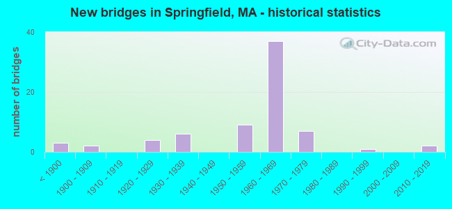
- New bridges - historical statistics
- 3Before 1900
- 21900-1909
- 41920-1929
- 61930-1939
- 91950-1959
- 371960-1969
- 71970-1979
- 11990-1999
- 22010-2019

- Reconstructed bridges - Historical Statistics
- 21920-1929
- 01930-1939
- 11940-1949
- 21950-1959
- 11960-1969
- 11970-1979
- 11980-1989
- 21990-1999
- 12000-2009
- 52010-2019


- Bridge Condition - Deck
- 3.7%Excellent
- 3.7%Very good
- 25.9%Good
- 40.7%Satisfactory
- 22.2%Fair
- 3.7%Poor

- Bridge Condition - Superstructure
- 5.1%Very good
- 13.6%Good
- 33.9%Satisfactory
- 40.7%Fair
- 6.8%Poor

- Bridge Condition - Substructure
- 1.7%Very good
- 20.3%Good
- 44.1%Satisfactory
- 30.5%Fair
- 3.4%Poor

- Bridge Condition - Channel
- 28.6%Good
- 64.3%Satisfactory
- 7.1%Fair
Find on map >> Show street view
Structure Number: S240030UJDOTNBI, Location: NORTH END BRIDGE (Lat: 42.108856, Lng: -72.613983), Route carried "on" structure: US 20, Year Built: 1924, Year Reconstructed: 1984, Status: Open, Structure Length: 36.13m (118.54ft), Average Daily Traffic: 31,000 (year 2019), Truck Traffic: 6%, Average Future Daily Traffic: 23,690 (year 2032), Design Load: HS 20, Features Intersected: WATER CONNECTICUT RIVER
Minimum Vertical Clearance: 30+ m (98+ ft), Kilometerpoint: 100.774, Lanes on structure: 4, Base Highway Network: Yes, Owner: State Highway Agency, Approaching Roadway Width: 21.3m (69.9ft), Navigation Control: Yes ( Vertical Clearance: 48.8m (160.1ft), Horizontal Clearance: 8.5m (27.9ft)), Material/Design: Steel, Design/Construction: Truss - Deck, Number Of Spans In Main Unit: 7, Number Of Approach Spans: 2, Length of Maximum Span: 50.2m (164.7ft), Curb or Sidewalk Widths: Left: 1.8m (5.9ft), Right: 1.8m (5.9ft), Curb-To-Curb Width: 16.5m (54.1ft), Out-to-Out Width: 21.3m (69.9ft)
Condition: Deck: Fair, Superstructure: Fair, Substructure: Fair, Channel: Satisfactory, Operating Rating: 56.4 metric tons, Method Used To Determine Operating Rating: Load Factor (LF), Inventory Rating: 33.8 metric tons, Method Used To Determine Inventory Rating: Load Factor (LF), Structural Evaluation: Somewhat better than minimum adequacy, Deck Geometry: Meets minimum limits, Waterway Adequacy: Equal to present desirable criteria, Approach Roadway Alignment: Somewhat better than minimum adequacy, Length Of Structure Improvement: 36.20m (118.77ft), Designated Inspection Frequency: Every 24 months, Critical Feature Inspection Frequency: Every 24 months, Underwater Inspection Frequency: Every 36 months, Inspection Date: August 2021, Critical Feature Inspection Date: August 2021, Underwater Inspection Date: August 2020, Bridge Improvement Cost: $30,288,000, Roadway Improvement Cost: $3,029,000, Total Project Cost: $45,433,000 ( Estimate for 2022), Deck Structure Type: Concrete Cast-file-Place, Wearing Surface/Protective System: Wearing Surface: Bituminous, Membrane: Built-up
Find on map >> Show street view
Structure Number: S2401614JDOT634, Location: AT JCT ALBANY ST. (Lat: 42.115478, Lng: -72.581867), Route carried "on" structure: City street , Year Built: 1934, Status: Posted for load, Structure Length: 2.87m (9.42ft), Average Daily Traffic: 35,000 (year 2019), Truck Traffic: 6%, Average Future Daily Traffic: 24,915 (year 2031), Features Intersected: RR CSX, Facility Carried by Structure: HWY ARMORY ST
Minimum Vertical Clearance: 30+ m (98+ ft), Kilometerpoint: 0.000, Lanes on structure: 3, Base Highway Network: Yes, Owner: State Highway Agency, Approaching Roadway Width: 11.0m (36.1ft), Material/Design: Steel, Design/Construction: Stringer/Multi-beam, Number Of Spans In Main Unit: 1, Length of Maximum Span: 27.6m (90.6ft), Curb or Sidewalk Widths: Left: 1.7m (5.6ft), Right: 1.7m (5.6ft), Curb-To-Curb Width: 11.0m (36.1ft), Out-to-Out Width: 15.1m (49.5ft)
Condition: Deck: Poor, Superstructure: Poor, Substructure: Satisfactory, Operating Rating: 45.7 metric tons, Method Used To Determine Operating Rating: Load Factor (LF), Inventory Rating: 27.4 metric tons, Method Used To Determine Inventory Rating: Load Factor (LF), Structural Evaluation: Meets minimum limits, Deck Geometry: High priority of replacement, Underclear: Somewhat better than minimum adequacy, Approach Roadway Alignment: Equal to present desirable criteria, Length Of Structure Improvement: 3.80m (12.47ft), Designated Inspection Frequency: Every 12 months, Other Special Inspection Frequency: Every 12 months, Inspection Date: March 2021, Other Special Inspection Date: March 2021, Bridge Improvement Cost: $4,479,000, Roadway Improvement Cost: $448,000, Total Project Cost: $6,719,000 ( Estimate for 2022), Deck Structure Type: Concrete Cast-file-Place, Wearing Surface/Protective System: Wearing Surface: Integral Concrete
Find on map >> Show street view
Structure Number: S2401714KDOT634, Location: ADJACENT TO I-291 (Lat: 42.126364, Lng: -72.567019), Route carried "on" structure: City street , Year Built: 1956, Year Reconstructed: 1969, Status: Temporarily open, Structure Length: 2.63m (8.63ft), Average Daily Traffic: 34,300 (year 2019), Truck Traffic: 3%, Average Future Daily Traffic: 29,817 (year 2032), Design Load: HS 20, Features Intersected: RR CSX, Facility Carried by Structure: HWY ST JAMES AVE
Minimum Vertical Clearance: 30+ m (98+ ft), Kilometerpoint: 0.000, Lanes on structure: 4, Owner: State Highway Agency, Approaching Roadway Width: 25.3m (83.0ft), Skew: 33 degrees, Material/Design: Steel, Design/Construction: Stringer/Multi-beam, Number Of Spans In Main Unit: 1, Length of Maximum Span: 25.5m (83.7ft), Curb or Sidewalk Widths: Left: 1.8m (5.9ft), Right: 0.5m (1.6ft), Curb-To-Curb Width: 21.9m (71.9ft), Out-to-Out Width: 28.0m (91.9ft)
Condition: Deck: Poor, Superstructure: Fair, Substructure: Fair, Operating Rating: 49.1 metric tons, Method Used To Determine Operating Rating: Allowable Stress (AS), Inventory Rating: 24.9 metric tons, Method Used To Determine Inventory Rating: Allowable Stress (AS), Structural Evaluation: Somewhat better than minimum adequacy, Deck Geometry: Superior to present desirable criteria, Underclear: Somewhat better than minimum adequacy, Approach Roadway Alignment: Equal to present desirable criteria, Length Of Structure Improvement: 2.70m (8.86ft), Designated Inspection Frequency: Every 12 months, Other Special Inspection Frequency: Every 12 months, Inspection Date: Febuary 2021, Other Special Inspection Date: Febuary 2022, Bridge Improvement Cost: $2,970,000, Roadway Improvement Cost: $298,000, Total Project Cost: $4,456,000 ( Estimate for 2022), Deck Structure Type: Concrete Cast-file-Place, Wearing Surface/Protective System: Wearing Surface: Bituminous, Membrane: Built-up
Find on map >> Show street view
Structure Number: S2401814LDOT634, Location: .1 M S JCT COTTAGE ST. (Lat: 42.140386, Lng: -72.524350), Route carried "on" structure: City street , Year Built: 1920, Status: Open, Structure Length: 2.23m (7.32ft), Average Daily Traffic: 21,300 (year 2019), Truck Traffic: 8%, Average Future Daily Traffic: 47,379 (year 2032), Design Load: H 20, Features Intersected: RR CSX, Facility Carried by Structure: HWY BRKSHRE AVE
Minimum Vertical Clearance: 30+ m (98+ ft), Kilometerpoint: 4.828, Lanes on structure: 4, Owner: State Highway Agency, Approaching Roadway Width: 17.1m (56.1ft), Skew: 4 degrees, Material/Design: Steel, Design/Construction: Stringer/Multi-beam, Number Of Spans In Main Unit: 1, Length of Maximum Span: 20.1m (65.9ft), Curb or Sidewalk Widths: Left: 1.8m (5.9ft), Right: 1.8m (5.9ft), Curb-To-Curb Width: 16.8m (55.1ft), Out-to-Out Width: 21.1m (69.2ft)
Condition: Deck: Fair, Superstructure: Fair, Substructure: Fair, Operating Rating: 58.0 metric tons, Method Used To Determine Operating Rating: Load Factor (LF), Inventory Rating: 34.7 metric tons, Method Used To Determine Inventory Rating: Load Factor (LF), Structural Evaluation: Somewhat better than minimum adequacy, Deck Geometry: Somewhat better than minimum adequacy, Underclear: Somewhat better than minimum adequacy, Approach Roadway Alignment: Equal to present minimum criteria, Length Of Structure Improvement: 2.30m (7.55ft), Designated Inspection Frequency: Every 24 months, Inspection Date: September 2021, Bridge Improvement Cost: $1,907,000, Roadway Improvement Cost: $191,000, Total Project Cost: $2,861,000 ( Estimate for 2022), Deck Structure Type: Concrete Cast-file-Place, Wearing Surface/Protective System: Wearing Surface: Bituminous
Find on map >> Show street view
Structure Number: S24019AKCDOT634, Location: .35 M N JCT BOSTON RD. (Lat: 42.145336, Lng: -72.503236), Route carried "on" structure: US 20, Year Built: 1994, Status: Open, Structure Length: 4.65m (15.26ft), Average Daily Traffic: 23,146 (year 2017), Truck Traffic: 3%, Average Future Daily Traffic: 34,745 (year 2032), Design Load: HS 20, Features Intersected: RR CSX
Minimum Vertical Clearance: 30+ m (98+ ft), Kilometerpoint: 111.315, Lanes on structure: 2, Owner: State Highway Agency, Approaching Roadway Width: 13.4m (44.0ft), Material/Design: Steel continuous, Design/Construction: Stringer/Multi-beam, Number Of Spans In Main Unit: 3, Length of Maximum Span: 24.8m (81.4ft), Curb or Sidewalk Widths: Left: 1.9m (6.2ft), Right: 1.9m (6.2ft), Curb-To-Curb Width: 13.4m (44.0ft), Out-to-Out Width: 17.9m (58.7ft)
Condition: Deck: Good, Superstructure: Very good, Substructure: Good, Operating Rating: 54.0 metric tons, Method Used To Determine Operating Rating: Allowable Stress (AS), Inventory Rating: 34.2 metric tons, Method Used To Determine Inventory Rating: Allowable Stress (AS), Structural Evaluation: Better than present minimum criteria, Deck Geometry: Equal to present minimum criteria, Underclear: Somewhat better than minimum adequacy, Approach Roadway Alignment: Equal to present desirable criteria, Length Of Structure Improvement: 4.70m (15.42ft), Designated Inspection Frequency: Every 24 months, Inspection Date: Febuary 2021, Bridge Improvement Cost: $331,000, Roadway Improvement Cost: $34,000, Total Project Cost: $497,000 ( Estimate for 2022), Deck Structure Type: Concrete Cast-file-Place, Wearing Surface/Protective System: Wearing Surface: Bituminous, Membrane: Preformed Fabric, Deck Protection: Epoxy Coated Reinforcing
Find on map >> Show street view
Structure Number: S2402214HDOT634, Location: .15 M W JCT ROCUS ST. (Lat: 42.150822, Lng: -72.527569), Route carried "on" structure: US 20, Year Built: 1968, Status: Open, Structure Length: 2.81m (9.22ft), Average Daily Traffic: 25,200 (year 2018), Truck Traffic: 9%, Average Future Daily Traffic: 39,167 (year 2031), Design Load: H 20, Features Intersected: RR CSX SPURR
Minimum Vertical Clearance: 30+ m (98+ ft), Kilometerpoint: 116.352, Lanes on structure: 4, Base Highway Network: Yes, Owner: State Highway Agency, Approaching Roadway Width: 14.6m (47.9ft), Skew: 3 degrees, Material/Design: Steel, Design/Construction: Stringer/Multi-beam, Number Of Spans In Main Unit: 1, Length of Maximum Span: 26.8m (87.9ft), Curb or Sidewalk Widths: Left: 1.5m (4.9ft), Right: 1.5m (4.9ft), Curb-To-Curb Width: 14.6m (47.9ft), Out-to-Out Width: 18.5m (60.7ft)
Condition: Deck: Good, Superstructure: Good, Substructure: Satisfactory, Operating Rating: 54.8 metric tons, Method Used To Determine Operating Rating: Load Factor (LF), Inventory Rating: 32.8 metric tons, Method Used To Determine Inventory Rating: Load Factor (LF), Structural Evaluation: Equal to present minimum criteria, Deck Geometry: High priority of replacement, Underclear: Equal to present minimum criteria, Approach Roadway Alignment: Equal to present desirable criteria, Length Of Structure Improvement: 2.90m (9.51ft), Designated Inspection Frequency: Every 24 months, Inspection Date: May 2020, Bridge Improvement Cost: $2,051,000, Roadway Improvement Cost: $206,000, Total Project Cost: $3,077,000 ( Estimate for 2022), Deck Structure Type: Concrete Cast-file-Place, Wearing Surface/Protective System: Wearing Surface: Bituminous, Membrane: Built-up
Find on map >> Show street view
Structure Number: S2402614MDOT634, Location: S JCT OF ALBANY ST. (Lat: 42.114917, Lng: -72.581167), Route carried "on" structure: City street , Year Built: 1934, Status: Open, Structure Length: 1.98m (6.50ft), Average Daily Traffic: 20,285 (year 2016), Truck Traffic: 3%, Average Future Daily Traffic: 6,159 (year 2031), Features Intersected: RR CSX (ABANDONED), Facility Carried by Structure: HWY ARMORY ST
Minimum Vertical Clearance: 30+ m (98+ ft), Kilometerpoint: 0.000, Lanes on structure: 2, Base Highway Network: Yes, Owner: State Highway Agency, Approaching Roadway Width: 11.0m (36.1ft), Material/Design: Steel, Design/Construction: Stringer/Multi-beam, Number Of Spans In Main Unit: 1, Length of Maximum Span: 18.7m (61.4ft), Curb or Sidewalk Widths: Left: 1.8m (5.9ft), Right: 1.8m (5.9ft), Curb-To-Curb Width: 11.0m (36.1ft), Out-to-Out Width: 15.2m (49.9ft)
Condition: Deck: Fair, Superstructure: Fair, Substructure: Satisfactory, Operating Rating: 50.4 metric tons, Method Used To Determine Operating Rating: Load Factor (LF), Inventory Rating: 30.2 metric tons, Method Used To Determine Inventory Rating: Load Factor (LF), Structural Evaluation: Somewhat better than minimum adequacy, Deck Geometry: Meets minimum limits, Underclear: High priority of corrective action, Approach Roadway Alignment: Better than present minimum criteria, Length Of Structure Improvement: 2.00m (6.56ft), Designated Inspection Frequency: Every 24 months, Inspection Date: December 2020, Bridge Improvement Cost: $1,195,000, Roadway Improvement Cost: $120,000, Total Project Cost: $1,793,000 ( Estimate for 2022), Deck Structure Type: Concrete Cast-file-Place, Wearing Surface/Protective System: Wearing Surface: Bituminous
Find on map >> Show street view
Structure Number: S2402814NDOT634, Location: .1 M S JCT ALBANY ST. (Lat: 42.121283, Lng: -72.570239), Route carried "on" structure: City street , Year Built: 1903, Year Reconstructed: 1992, Status: Posted for load, Structure Length: 1.57m (5.15ft), Average Daily Traffic: 21,207 (year 2019), Truck Traffic: 6%, Average Future Daily Traffic: 24,506 (year 2032), Features Intersected: RR CONRAIL (ABANDNED), Facility Carried by Structure: HWY ST JAMES AVE
Minimum Vertical Clearance: 30+ m (98+ ft), Kilometerpoint: 0.000, Lanes on structure: 2, Owner: State Highway Agency, Approaching Roadway Width: 12.8m (42.0ft), Skew: 4 degrees, Material/Design: Steel, Design/Construction: Girder and Floorbeam System, Number Of Spans In Main Unit: 1, Length of Maximum Span: 14.9m (48.9ft), Curb or Sidewalk Widths: Left: 2.4m (7.9ft), Right: 2.4m (7.9ft), Curb-To-Curb Width: 15.2m (49.9ft), Out-to-Out Width: 20.1m (65.9ft)
Condition: Deck: Fair, Superstructure: Poor, Substructure: Satisfactory, Operating Rating: 46.8 metric tons, Method Used To Determine Operating Rating: Load Factor (LF), Inventory Rating: 28.9 metric tons, Method Used To Determine Inventory Rating: Load Factor (LF), Structural Evaluation: Meets minimum limits, Deck Geometry: Superior to present desirable criteria, Underclear: High priority of replacement, Approach Roadway Alignment: Better than present minimum criteria, Length Of Structure Improvement: 2.30m (7.55ft), Designated Inspection Frequency: Every 6 months, Other Special Inspection Frequency: Every 6 months, Inspection Date: August 2021, Other Special Inspection Date: Febuary 2022, Bridge Improvement Cost: $2,200,000, Roadway Improvement Cost: $221,000, Total Project Cost: $3,301,000 ( Estimate for 2022), Deck Structure Type: Corrugated Steel, Wearing Surface/Protective System: Wearing Surface: Bituminous
Find on map >> Show street view
Structure Number: S2403015BDOTNBI, Location: MEMRL BR RR#61.43 (Lat: 42.099192, Lng: -72.594800), Route carried "on" structure: State highway 147, Year Built: 1922, Year Reconstructed: 1996, Status: Open, Structure Length: 47.12m (154.59ft), Average Daily Traffic: 18,907 (year 2017), Truck Traffic: 4%, Average Future Daily Traffic: 37,587 (year 2031), Design Load: HS 20, Features Intersected: COMB AMTRAK & CONN RIV
Minimum Vertical Clearance: 30+ m (98+ ft), Kilometerpoint: 9.495, Lanes on structure: 4, Base Highway Network: Yes, Owner: State Highway Agency, Approaching Roadway Width: 18.3m (60.0ft), Skew: 20 degrees, Navigation Control: Yes ( Vertical Clearance: 13.7m (44.9ft), Horizontal Clearance: 52.7m (172.9ft)), Material/Design: Concrete, Design/Construction: Arch - Deck, Number Of Spans In Main Unit: 7, Number Of Approach Spans: 10, Length of Maximum Span: 63.7m (209.0ft), Curb or Sidewalk Widths: Left: 2.7m (8.9ft), Right: 2.7m (8.9ft), Curb-To-Curb Width: 18.3m (60.0ft), Out-to-Out Width: 25.2m (82.7ft)
Condition: Deck: Satisfactory, Superstructure: Fair, Substructure: Fair, Channel: Fair, Operating Rating: 70.1 metric tons, Method Used To Determine Operating Rating: Load Factor (LF), Inventory Rating: 42.1 metric tons, Method Used To Determine Inventory Rating: Load Factor (LF), Structural Evaluation: Somewhat better than minimum adequacy, Deck Geometry: Somewhat better than minimum adequacy, Underclear: High priority of corrective action, Waterway Adequacy: Equal to present desirable criteria, Approach Roadway Alignment: Equal to present minimum criteria, Length Of Structure Improvement: 47.20m (154.86ft), Designated Inspection Frequency: Every 24 months, Underwater Inspection Frequency: Every 36 months, Inspection Date: August 2020, Underwater Inspection Date: September 2019, Bridge Improvement Cost: $46,722,000, Roadway Improvement Cost: $4,673,000, Total Project Cost: $70,084,000 ( Estimate for 2022), Deck Structure Type: Concrete Cast-file-Place, Wearing Surface/Protective System: Wearing Surface: Bituminous, Membrane: Preformed Fabric, Deck Protection: Epoxy Coated Reinforcing
Find on map >> Show street view
Structure Number: S240320N7MUNNBI, Location: .2 MI NW OF WILBRAHAM RD (Lat: 42.115958, Lng: -72.550578), Route carried "on" structure: City street , Year Built: 1937, Year Reconstructed: 2011, Status: Open, Structure Length: 1.58m (5.18ft), Average Daily Traffic: 20,690 (year 2003), Truck Traffic: 6%, Average Future Daily Traffic: 32,676 (year 2032), Features Intersected: HWY ROOSEVELT AVE, Facility Carried by Structure: HWY STATE ST
Minimum Vertical Clearance: 30+ m (98+ ft), Kilometerpoint: 3.814, Lanes on structure: 4, Lanes under structure: 2, Base Highway Network: Yes, Owner: City or Municipal Highway Agency, Approaching Roadway Width: 16.3m (53.5ft), Material/Design: Concrete, Design/Construction: Frame, Number Of Spans In Main Unit: 1, Length of Maximum Span: 15.8m (51.8ft), Curb or Sidewalk Widths: Left: 2.2m (7.2ft), Right: 2.2m (7.2ft), Curb-To-Curb Width: 16.3m (53.5ft), Out-to-Out Width: 22.3m (73.2ft)
Condition: Superstructure: Satisfactory, Substructure: Satisfactory, Operating Rating: 73.1 metric tons, Method Used To Determine Operating Rating: Load Factor (LF), Structural Evaluation: High priority of corrective action, Deck Geometry: Meets minimum limits, Underclear: High priority of corrective action, Approach Roadway Alignment: Better than present minimum criteria, Length Of Structure Improvement: 1.60m (5.25ft), Designated Inspection Frequency: Every 24 months, Inspection Date: May 2021, Bridge Improvement Cost: $1,402,000, Roadway Improvement Cost: $141,000, Total Project Cost: $2,104,000 ( Estimate for 2022), Wearing Surface/Protective System: Wearing Surface: Bituminous
Find on map >> Show street view
Structure Number: S240330N8MUNNBI, Location: .5 M S OF WILBRAHAM RD (Lat: 42.105800, Lng: -72.546456), Route carried "on" structure: City street , Year Built: 1937, Year Reconstructed: 1999, Status: Open, Structure Length: 7.71m (25.30ft), Average Daily Traffic: 4,785 (year 2020), Truck Traffic: 3%, Average Future Daily Traffic: 14,845 (year 2033), Design Load: HS 20, Features Intersected: WATER WATERSHOPS POND, Facility Carried by Structure: HWY ROOSEVELT AV
Minimum Vertical Clearance: 30+ m (98+ ft), Kilometerpoint: 2.333, Lanes on structure: 3, Base Highway Network: Yes, Owner: City or Municipal Highway Agency, Approaching Roadway Width: 12.2m (40.0ft), Material/Design: Steel continuous, Design/Construction: Stringer/Multi-beam, Number Of Spans In Main Unit: 3, Length of Maximum Span: 27.4m (89.9ft), Curb or Sidewalk Widths: Left: 2.4m (7.9ft), Right: 2.4m (7.9ft), Curb-To-Curb Width: 12.2m (40.0ft), Out-to-Out Width: 18.2m (59.7ft)
Condition: Deck: Good, Superstructure: Good, Substructure: Fair, Channel: Satisfactory, Operating Rating: 66.7 metric tons, Method Used To Determine Operating Rating: Load Factor (LF), Inventory Rating: 40.0 metric tons, Method Used To Determine Inventory Rating: Load Factor (LF), Structural Evaluation: Somewhat better than minimum adequacy, Deck Geometry: Meets minimum limits, Waterway Adequacy: Equal to present desirable criteria, Approach Roadway Alignment: Equal to present minimum criteria, Length Of Structure Improvement: 7.80m (25.59ft), Designated Inspection Frequency: Every 24 months, Underwater Inspection Frequency: Every 48 months, Inspection Date: Febuary 2022, Underwater Inspection Date: May 2018, Bridge Improvement Cost: $5,577,000, Roadway Improvement Cost: $558,000, Total Project Cost: $8,366,000 ( Estimate for 2022), Deck Structure Type: Concrete Cast-file-Place, Wearing Surface/Protective System: Wearing Surface: Bituminous, Membrane: Preformed Fabric, Deck Protection: Epoxy Coated Reinforcing
Find on map >> Show street view
Structure Number: S24037BKHMUNNBI, Location: .39 MI N ARCH ST (Lat: 42.118797, Lng: -72.610261), Route carried "on" structure: City street , Year Built: 1974, Status: Open, Structure Length: 1.64m (5.38ft), Average Daily Traffic: 14,095 (year 2021), Truck Traffic: 7%, Design Load: HS 20, Features Intersected: OTHER GERENA TUNNEL, Facility Carried by Structure: HWY BIRNIE AVE
Minimum Vertical Clearance: 30+ m (98+ ft), Kilometerpoint: 0.000, Lanes on structure: 2, Owner: Town or Township Highway Agency, Approaching Roadway Width: 12.2m (40.0ft), Material/Design: Prestressed concrete, Design/Construction: Box Beam or Girders - Multiple, Number Of Spans In Main Unit: 1, Length of Maximum Span: 15.8m (51.8ft), Curb or Sidewalk Widths: Left: 3.0m (9.8ft), Right: 3.0m (9.8ft), Curb-To-Curb Width: 12.2m (40.0ft), Out-to-Out Width: 23.8m (78.1ft)
Condition: Deck: Fair, Superstructure: Fair, Substructure: Fair, Operating Rating: 86.2 metric tons, Method Used To Determine Operating Rating: Load Factor (LF), Inventory Rating: 56.9 metric tons, Method Used To Determine Inventory Rating: Load Factor (LF), Structural Evaluation: Somewhat better than minimum adequacy, Deck Geometry: Better than present minimum criteria, Approach Roadway Alignment: Better than present minimum criteria, Length Of Structure Improvement: 1.70m (5.58ft), Designated Inspection Frequency: Every 24 months, Inspection Date: May 2021, Bridge Improvement Cost: $1,590,000, Roadway Improvement Cost: $160,000, Total Project Cost: $2,386,000 ( Estimate for 2022), Deck Structure Type: Concrete Precast Panels, Wearing Surface/Protective System: Wearing Surface: Bituminous, Membrane: Built-up
Find on map >> Show street view
Structure Number: S240380N5MUNNBI, Location: .5M SE OF RTE 116 (Lat: 42.093639, Lng: -72.569728), Route carried "on" structure: City street , Year Built: 1925, Year Reconstructed: 1955, Status: Open, Structure Length: 0.81m (2.66ft), Average Daily Traffic: 17,844 (year 2019), Truck Traffic: 2%, Average Future Daily Traffic: 8,844 (year 2032), Design Load: H 20, Features Intersected: WATER MILL RIVER, Facility Carried by Structure: HWY MILL ST
Minimum Vertical Clearance: 30+ m (98+ ft), Kilometerpoint: 1.078, Lanes on structure: 2, Owner: City or Municipal Highway Agency, Approaching Roadway Width: 10.1m (33.1ft), Material/Design: Steel, Design/Construction: Stringer/Multi-beam, Number Of Spans In Main Unit: 1, Length of Maximum Span: 6.9m (22.6ft), Curb or Sidewalk Widths: Left: 2.1m (6.9ft), Right: 2.1m (6.9ft), Curb-To-Curb Width: 14.6m (47.9ft), Out-to-Out Width: 19.5m (64.0ft)
Condition: Deck: Good, Superstructure: Satisfactory, Substructure: Fair, Channel: Satisfactory, Operating Rating: 47.9 metric tons, Method Used To Determine Operating Rating: Load Factor (LF), Inventory Rating: 28.7 metric tons, Method Used To Determine Inventory Rating: Load Factor (LF), Structural Evaluation: Somewhat better than minimum adequacy, Deck Geometry: Superior to present desirable criteria, Waterway Adequacy: Better than present minimum criteria, Approach Roadway Alignment: Equal to present minimum criteria, Length Of Structure Improvement: 0.90m (2.95ft), Designated Inspection Frequency: Every 24 months, Underwater Inspection Frequency: Every 36 months, Inspection Date: June 2021, Underwater Inspection Date: Febuary 2021, Bridge Improvement Cost: $690,000, Roadway Improvement Cost: $70,000, Total Project Cost: $1,036,000 ( Estimate for 2022), Deck Structure Type: Concrete Cast-file-Place, Wearing Surface/Protective System: Wearing Surface: Bituminous, Membrane: Built-up
Find on map >> Show street view
Structure Number: S240390N2MUNNBI, Location: .3 MI SW OF CENTRAL ST (Lat: 42.094214, Lng: -72.567817), Route carried "on" structure: City street , Year Built: 1957, Status: Open, Structure Length: 1.46m (4.79ft), Average Daily Traffic: 9,698 (year 2019), Truck Traffic: 5%, Average Future Daily Traffic: 7,581 (year 2032), Design Load: H 20, Features Intersected: WATER MILL RIVER, Facility Carried by Structure: HWY HANCOCK ST
Minimum Vertical Clearance: 30+ m (98+ ft), Kilometerpoint: 0.113, Lanes on structure: 2, Owner: City or Municipal Highway Agency, Approaching Roadway Width: 9.1m (29.9ft), Skew: 4 degrees, Material/Design: Prestressed concrete, Design/Construction: Slab, Number Of Spans In Main Unit: 1, Length of Maximum Span: 12.8m (42.0ft), Curb or Sidewalk Widths: Left: 1.6m (5.2ft), Right: 1.6m (5.2ft), Curb-To-Curb Width: 11.6m (38.1ft), Out-to-Out Width: 15.2m (49.9ft)
Condition: Deck: Satisfactory, Superstructure: Satisfactory, Substructure: Satisfactory, Channel: Satisfactory, Operating Rating: 43.4 metric tons, Method Used To Determine Operating Rating: Load Factor (LF), Inventory Rating: 25.9 metric tons, Method Used To Determine Inventory Rating: Load Factor (LF), Structural Evaluation: Equal to present minimum criteria, Deck Geometry: Somewhat better than minimum adequacy, Waterway Adequacy: Equal to present minimum criteria, Approach Roadway Alignment: Somewhat better than minimum adequacy, Length Of Structure Improvement: 1.50m (4.92ft), Designated Inspection Frequency: Every 24 months, Inspection Date: June 2021, Bridge Improvement Cost: $896,000, Roadway Improvement Cost: $90,000, Total Project Cost: $1,345,000 ( Estimate for 2022), Deck Structure Type: Concrete Precast Panels, Wearing Surface/Protective System: Wearing Surface: Bituminous, Membrane: Built-up
Find on map >> Show street view
Structure Number: S240400N9MUNNBI, Location: AT JCT OF CENTRAL ST (Lat: 42.097103, Lng: -72.563672), Route carried "on" structure: City street , Year Built: 1875, Year Reconstructed: 1927, Status: Open, Structure Length: 1.16m (3.81ft), Average Daily Traffic: 7,878 (year 2018), Truck Traffic: 6%, Average Future Daily Traffic: 25,269 (year 2032), Features Intersected: WATER MILL RIVER, Facility Carried by Structure: HWY ALLEN ST
Minimum Vertical Clearance: 30+ m (98+ ft), Kilometerpoint: 0.193, Lanes on structure: 4, Owner: City or Municipal Highway Agency, Approaching Roadway Width: 16.5m (54.1ft), Skew: 20 degrees, Material/Design: Masonry, Design/Construction: Arch - Deck, Number Of Spans In Main Unit: 1, Length of Maximum Span: 11.6m (38.1ft), Curb or Sidewalk Widths: Left: 1.8m (5.9ft), Right: 1.9m (6.2ft), Curb-To-Curb Width: 16.2m (53.1ft), Out-to-Out Width: 20.6m (67.6ft)
Condition: Superstructure: Fair, Substructure: Satisfactory, Channel: Satisfactory, Operating Rating: 43.5 metric tons, Method Used To Determine Operating Rating: Load Factor (LF), Inventory Rating: 43.5 metric tons, Method Used To Determine Inventory Rating: Allowable Stress (AS), Structural Evaluation: Somewhat better than minimum adequacy, Deck Geometry: Meets minimum limits, Waterway Adequacy: Better than present minimum criteria, Approach Roadway Alignment: Somewhat better than minimum adequacy, Length Of Structure Improvement: 1.20m (3.94ft), Designated Inspection Frequency: Every 24 months, Inspection Date: August 2021, Bridge Improvement Cost: $972,000, Roadway Improvement Cost: $98,000, Total Project Cost: $1,459,000 ( Estimate for 2022)
Find on map >> Show street view
Structure Number: S240400NCMUNNBI, Location: INT RIFLE ST (Lat: 42.097100, Lng: -72.563678), Route carried "on" structure: City street , Year Built: 1875, Year Reconstructed: 1927, Status: Open, Structure Length: 0.85m (2.79ft), Average Daily Traffic: 20,100 (year 2019), Truck Traffic: 1%, Average Future Daily Traffic: 44,220 (year 2032), Features Intersected: WATER MILL RIVER, Facility Carried by Structure: HWY ALLEN ST
Minimum Vertical Clearance: 30+ m (98+ ft), Kilometerpoint: 0.161, Lanes on structure: 4, Owner: City or Municipal Highway Agency, Approaching Roadway Width: 16.5m (54.1ft), Skew: 20 degrees, Material/Design: Masonry, Design/Construction: Arch - Deck, Number Of Spans In Main Unit: 1, Length of Maximum Span: 8.5m (27.9ft), Curb or Sidewalk Widths: Left: 1.8m (5.9ft), Right: 2.3m (7.5ft), Curb-To-Curb Width: 16.2m (53.1ft), Out-to-Out Width: 20.6m (67.6ft)
Condition: Superstructure: Satisfactory, Substructure: Good, Channel: Satisfactory, Operating Rating: 43.3 metric tons, Method Used To Determine Operating Rating: Load Factor (LF), Inventory Rating: 43.3 metric tons, Method Used To Determine Inventory Rating: Load Factor (LF), Structural Evaluation: Equal to present minimum criteria, Deck Geometry: Meets minimum limits, Waterway Adequacy: Equal to present desirable criteria, Approach Roadway Alignment: Somewhat better than minimum adequacy, Length Of Structure Improvement: 0.90m (2.95ft), Designated Inspection Frequency: Every 24 months, Underwater Inspection Frequency: Every 48 months, Inspection Date: June 2021, Underwater Inspection Date: May 2019, Bridge Improvement Cost: $348,000, Roadway Improvement Cost: $35,000, Total Project Cost: $523,000 ( Estimate for 2022)
Find on map >> Show street view
Structure Number: S240410N4MUNNBI, Location: AT JCT OF MILL ST (Lat: 42.090394, Lng: -72.576897), Route carried "on" structure: City street , Year Built: 1884, Year Reconstructed: 1946, Status: Open, Structure Length: 0.61m (2.00ft), Average Daily Traffic: 28,060 (year 2019), Truck Traffic: 4%, Average Future Daily Traffic: 22,110 (year 2032), Features Intersected: WATER MILL RIVER, Facility Carried by Structure: HWY BELMONT AVE
Minimum Vertical Clearance: 30+ m (98+ ft), Kilometerpoint: 0.016, Lanes on structure: 6, Base Highway Network: Yes, Owner: City or Municipal Highway Agency, Approaching Roadway Width: 35.4m (116.1ft), Skew: 29 degrees, Material/Design: Masonry, Design/Construction: Arch - Deck, Number Of Spans In Main Unit: 1, Length of Maximum Span: 6.1m (20.0ft), Curb or Sidewalk Widths: Left: 1.8m (5.9ft), Right: 1.8m (5.9ft), Curb-To-Curb Width: 44.4m (145.7ft), Out-to-Out Width: 65.6m (215.2ft)
Condition: Superstructure: Fair, Substructure: Satisfactory, Channel: Good, Inventory Rating: 86.1 metric tons, Method Used To Determine Inventory Rating: Allowable Stress (AS), Structural Evaluation: Somewhat better than minimum adequacy, Deck Geometry: Superior to present desirable criteria, Waterway Adequacy: Somewhat better than minimum adequacy, Approach Roadway Alignment: Somewhat better than minimum adequacy, Length Of Structure Improvement: 0.70m (2.30ft), Designated Inspection Frequency: Every 24 months, Inspection Date: September 2021, Bridge Improvement Cost: $1,804,000, Roadway Improvement Cost: $181,000, Total Project Cost: $2,707,000 ( Estimate for 2022)
Find on map >> Show street view
Structure Number: S240420WEDOTNBI, Location: JCT I-91 (Lat: 42.082622, Lng: -72.579144), Route carried "on" structure: US 5, Year Built: 1954, Status: Open, Structure Length: 3.54m (11.61ft), Average Daily Traffic: 14,000 (year 2000), Truck Traffic: 10%, Average Future Daily Traffic: 22,110 (year 2031), Design Load: H 20, Features Intersected: I 91
Minimum Vertical Clearance: 30+ m (98+ ft), Kilometerpoint: 6.759, Lanes on structure: 2, Lanes under structure: 4, Owner: State Highway Agency, Approaching Roadway Width: 8.5m (27.9ft), Skew: 9 degrees, Material/Design: Steel, Design/Construction: Stringer/Multi-beam, Number Of Spans In Main Unit: 2, Length of Maximum Span: 17.0m (55.8ft), Curb or Sidewalk Widths: Left: 0.9m (3.0ft), Right: 0.9m (3.0ft), Curb-To-Curb Width: 8.5m (27.9ft), Out-to-Out Width: 11.6m (38.1ft)
Condition: Deck: Satisfactory, Superstructure: Satisfactory, Substructure: Satisfactory, Operating Rating: 48.8 metric tons, Method Used To Determine Operating Rating: Allowable Stress (AS), Inventory Rating: 28.4 metric tons, Method Used To Determine Inventory Rating: Allowable Stress (AS), Structural Evaluation: Equal to present minimum criteria, Deck Geometry: High priority of replacement, Underclear: Meets minimum limits, Approach Roadway Alignment: Better than present minimum criteria, Length Of Structure Improvement: 3.60m (11.81ft), Designated Inspection Frequency: Every 24 months, Inspection Date: August 2020, Bridge Improvement Cost: $1,641,000, Roadway Improvement Cost: $165,000, Total Project Cost: $2,462,000 ( Estimate for 2022), Deck Structure Type: Concrete Cast-file-Place, Wearing Surface/Protective System: Wearing Surface: Bituminous, Membrane: Built-up
Find on map >> Show street view
Structure Number: S240430WDDOTNBI, Location: JCT I-91 (Lat: 42.081858, Lng: -72.578939), Route carried "on" structure: US 5, Year Built: 1954, Status: Open, Structure Length: 6.25m (20.51ft), Average Daily Traffic: 16,477 (year 2017), Truck Traffic: 3%, Average Future Daily Traffic: 24,795 (year 2031), Design Load: H 20, Features Intersected: I 91 & RMP A TO US 5 NB, Facility Carried by Structure: I 91 RAMP C
Minimum Vertical Clearance: 30+ m (98+ ft), Kilometerpoint: 6.598, Lanes on structure: 2, Lanes under structure: 6, Base Highway Network: Yes, Owner: State Highway Agency, Approaching Roadway Width: 8.5m (27.9ft), Skew: 9 degrees, Material/Design: Steel, Design/Construction: Stringer/Multi-beam, Number Of Spans In Main Unit: 4, Length of Maximum Span: 19.4m (63.6ft), Curb or Sidewalk Widths: Left: 0.9m (3.0ft), Right: 0.9m (3.0ft), Curb-To-Curb Width: 8.5m (27.9ft), Out-to-Out Width: 11.0m (36.1ft)
Condition: Deck: Fair, Superstructure: Satisfactory, Substructure: Satisfactory, Operating Rating: 43.6 metric tons, Method Used To Determine Operating Rating: Load Factor (LF), Inventory Rating: 26.2 metric tons, Method Used To Determine Inventory Rating: Load Factor (LF), Structural Evaluation: Equal to present minimum criteria, Deck Geometry: High priority of corrective action, Underclear: High priority of corrective action, Approach Roadway Alignment: Equal to present minimum criteria, Length Of Structure Improvement: 6.30m (20.67ft), Designated Inspection Frequency: Every 24 months, Inspection Date: August 2020, Bridge Improvement Cost: $2,723,000, Roadway Improvement Cost: $273,000, Total Project Cost: $4,085,000 ( Estimate for 2022), Deck Structure Type: Concrete Cast-file-Place, Wearing Surface/Protective System: Wearing Surface: Bituminous, Membrane: Built-up
Find on map >> Show street view
Structure Number: S240480N3MUNNBI, Location: AT NBR MILL RIVER (Lat: 42.129603, Lng: -72.513842), Route carried "on" structure: City street , Year Built: 1956, Status: Open, Structure Length: 0.70m (2.30ft), Average Daily Traffic: 2,715 (year 2019), Truck Traffic: 5%, Average Future Daily Traffic: 1,224 (year 2032), Design Load: H 15, Features Intersected: WATER N BR MILL RIVER, Facility Carried by Structure: HWY FOX RD
Minimum Vertical Clearance: 30+ m (98+ ft), Kilometerpoint: 0.097, Lanes on structure: 2, Owner: City or Municipal Highway Agency, Approaching Roadway Width: 7.9m (25.9ft), Material/Design: Prestressed concrete, Design/Construction: Slab, Number Of Spans In Main Unit: 1, Length of Maximum Span: 6.6m (21.7ft), Curb or Sidewalk Widths: Left: 1.5m (4.9ft), Right: 0.2m (0.7ft), Curb-To-Curb Width: 7.9m (25.9ft), Out-to-Out Width: 9.8m (32.2ft)
Condition: Deck: Good, Superstructure: Good, Substructure: Good, Channel: Good, Operating Rating: 78.3 metric tons, Method Used To Determine Operating Rating: Allowable Stress (AS), Inventory Rating: 51.4 metric tons, Method Used To Determine Inventory Rating: Allowable Stress (AS), Structural Evaluation: Better than present minimum criteria, Deck Geometry: High priority of corrective action, Waterway Adequacy: Equal to present minimum criteria, Approach Roadway Alignment: Somewhat better than minimum adequacy, Length Of Structure Improvement: 0.80m (2.62ft), Designated Inspection Frequency: Every 24 months, Inspection Date: June 2021, Bridge Improvement Cost: $415,000, Roadway Improvement Cost: $42,000, Total Project Cost: $623,000 ( Estimate for 2022), Deck Structure Type: Concrete Precast Panels, Wearing Surface/Protective System: Wearing Surface: Bituminous, Membrane: Built-up
Find on map >> Show street view
Structure Number: S24049121DOTNBI, Location: AT JCT I-91 (Lat: 42.077667, Lng: -72.580056), Route carried "on" structure: State highway 21, Year Built: 1958, Status: Open, Structure Length: 6.90m (22.64ft), Average Daily Traffic: 7,320 (year 2007), Truck Traffic: 3%, Average Future Daily Traffic: 11,560 (year 2032), Design Load: H 20, Features Intersected: I 91, Facility Carried by Structure: ST 83 SB RAMP Y
Minimum Vertical Clearance: 4.34m (14.24ft), Kilometerpoint: 6.276, Lanes on structure: 1, Lanes under structure: 6, Base Highway Network: Yes, Owner: State Highway Agency, Approaching Roadway Width: 6.7m (22.0ft), Skew: 9 degrees, Material/Design: Steel, Design/Construction: Stringer/Multi-beam, Number Of Spans In Main Unit: 4, Length of Maximum Span: 22.8m (74.8ft), Curb or Sidewalk Widths: Left: 0.8m (2.6ft), Right: 0.8m (2.6ft), Curb-To-Curb Width: 6.7m (22.0ft), Out-to-Out Width: 9.2m (30.2ft)
Condition: Deck: Satisfactory, Superstructure: Satisfactory, Substructure: Satisfactory, Operating Rating: 45.3 metric tons, Method Used To Determine Operating Rating: Allowable Stress (AS), Inventory Rating: 21.9 metric tons, Method Used To Determine Inventory Rating: Allowable Stress (AS), Structural Evaluation: Somewhat better than minimum adequacy, Deck Geometry: High priority of replacement, Underclear: Better than present minimum criteria, Approach Roadway Alignment: Better than present minimum criteria, Length Of Structure Improvement: 7.00m (22.97ft), Designated Inspection Frequency: Every 24 months, Inspection Date: March 2021, Bridge Improvement Cost: $2,530,000, Roadway Improvement Cost: $254,000, Total Project Cost: $3,796,000 ( Estimate for 2022), Deck Structure Type: Concrete Cast-file-Place, Wearing Surface/Protective System: Wearing Surface: Bituminous, Membrane: Built-up
Find on map >> Show street view
Structure Number: S24050120DOTNBI, Location: AT JCT I-91 (Lat: 42.077806, Lng: -72.580000), Route carried "on" structure: State highway 21, Year Built: 1958, Status: Open, Structure Length: 12.62m (41.40ft), Average Daily Traffic: 5,100 (year 2017), Truck Traffic: 5%, Average Future Daily Traffic: 6,633 (year 2032), Design Load: HS 20, Features Intersected: I 91 & ST83 SB, Facility Carried by Structure: ST 83 NB RAMP Z
Minimum Vertical Clearance: 30+ m (98+ ft), Kilometerpoint: 6.276, Lanes on structure: 1, Lanes under structure: 6, Base Highway Network: Yes, Owner: State Highway Agency, Approaching Roadway Width: 6.7m (22.0ft), Skew: 9 degrees, Material/Design: Steel, Design/Construction: Stringer/Multi-beam, Number Of Spans In Main Unit: 6, Length of Maximum Span: 24.4m (80.1ft), Curb or Sidewalk Widths: Left: 0.8m (2.6ft), Right: 0.8m (2.6ft), Curb-To-Curb Width: 6.7m (22.0ft), Out-to-Out Width: 9.2m (30.2ft)
Condition: Deck: Satisfactory, Superstructure: Good, Substructure: Satisfactory, Operating Rating: 36.0 metric tons, Method Used To Determine Operating Rating: Allowable Stress (AS), Inventory Rating: 16.1 metric tons, Method Used To Determine Inventory Rating: Allowable Stress (AS), Structural Evaluation: High priority of corrective action, Deck Geometry: High priority of replacement, Underclear: High priority of corrective action, Approach Roadway Alignment: Equal to present desirable criteria, Length Of Structure Improvement: 12.70m (41.67ft), Designated Inspection Frequency: Every 24 months, Inspection Date: March 2021, Bridge Improvement Cost: $4,590,000, Roadway Improvement Cost: $460,000, Total Project Cost: $6,886,000 ( Estimate for 2022), Deck Structure Type: Concrete Cast-file-Place, Wearing Surface/Protective System: Wearing Surface: Bituminous, Membrane: Built-up
Find on map >> Show street view
Structure Number: S240510WCDOTNBI, Location: JCT I-91 (Lat: 42.074908, Lng: -72.583214), Route carried "on" structure: US 5, Year Built: 1958, Status: Open, Structure Length: 8.17m (26.80ft), Average Daily Traffic: 14,588 (year 2017), Truck Traffic: 3%, Average Future Daily Traffic: 23,532 (year 2031), Design Load: H 20, Features Intersected: I 91
Minimum Vertical Clearance: 30+ m (98+ ft), Kilometerpoint: 5.649, Lanes on structure: 1, Lanes under structure: 5, Base Highway Network: Yes, Owner: State Highway Agency, Approaching Roadway Width: 9.8m (32.2ft), Skew: 3 degrees, Material/Design: Steel, Design/Construction: Stringer/Multi-beam, Number Of Spans In Main Unit: 4, Length of Maximum Span: 25.9m (85.0ft), Curb or Sidewalk Widths: Left: 0.6m (2.0ft), Right: 0.6m (2.0ft), Curb-To-Curb Width: 9.8m (32.2ft), Out-to-Out Width: 12.3m (40.4ft)
Condition: Deck: Satisfactory, Superstructure: Satisfactory, Substructure: Satisfactory, Operating Rating: 55.9 metric tons, Method Used To Determine Operating Rating: Load Factor (LF), Inventory Rating: 33.5 metric tons, Method Used To Determine Inventory Rating: Load Factor (LF), Structural Evaluation: Equal to present minimum criteria, Deck Geometry: Meets minimum limits, Underclear: Equal to present minimum criteria, Approach Roadway Alignment: Equal to present desirable criteria, Length Of Structure Improvement: 8.20m (26.90ft), Designated Inspection Frequency: Every 24 months, Inspection Date: August 2020, Bridge Improvement Cost: $2,784,000, Roadway Improvement Cost: $279,000, Total Project Cost: $4,177,000 ( Estimate for 2022), Deck Structure Type: Concrete Cast-file-Place, Wearing Surface/Protective System: Wearing Surface: Bituminous, Membrane: Built-up
Find on map >> Show street view
Structure Number: S2405410FDOTNBI, Location: MM 4.5 ON I-91 (Lat: 42.087578, Lng: -72.580828), Route carried "on" structure: Interstate 91, Year Built: 1963, Status: Open, Structure Length: 5.21m (17.09ft), Average Daily Traffic: 91,200 (year 1999), Truck Traffic: 6%, Average Future Daily Traffic: 144,032 (year 2031), Design Load: HS 20+Mod, Features Intersected: HWY MAIN ST (S END)
Minimum Vertical Clearance: 30+ m (98+ ft), Kilometerpoint: 7.274, Lanes on structure: 7, Lanes under structure: 6, Base Highway Network: Yes, Owner: State Highway Agency, Approaching Roadway Width: 26.8m (87.9ft), Skew: 31 degrees, Material/Design: Steel, Design/Construction: Stringer/Multi-beam, Number Of Spans In Main Unit: 4, Length of Maximum Span: 20.2m (66.3ft), Curb-To-Curb Width: 26.8m (87.9ft), Out-to-Out Width: 34.2m (112.2ft)
Condition: Deck: Fair, Superstructure: Satisfactory, Substructure: Satisfactory, Operating Rating: 51.5 metric tons, Method Used To Determine Operating Rating: Allowable Stress (AS), Inventory Rating: 30.6 metric tons, Method Used To Determine Inventory Rating: Allowable Stress (AS), Structural Evaluation: Equal to present minimum criteria, Deck Geometry: High priority of replacement, Underclear: High priority of corrective action, Approach Roadway Alignment: Better than present minimum criteria, Length Of Structure Improvement: 5.30m (17.39ft), Designated Inspection Frequency: Every 24 months, Inspection Date: July 2020, Bridge Improvement Cost: $7,120,000, Roadway Improvement Cost: $713,000, Total Project Cost: $10,681,000 ( Estimate for 2022), Deck Structure Type: Concrete Cast-file-Place, Wearing Surface/Protective System: Wearing Surface: Bituminous, Membrane: Built-up
Find on map >> Show street view
Structure Number: S2405510UDOTNBI, Location: .1 M N JCT MAIN ST. (Lat: 42.088642, Lng: -72.581219), Route carried "on" structure: Interstate 91, Year Built: 1961, Status: Open, Structure Length: 0.91m (2.99ft), Average Daily Traffic: 107,542 (year 2018), Truck Traffic: 5%, Average Future Daily Traffic: 169,143 (year 2033), Design Load: HS 20+Mod, Features Intersected: WATER MILL RIVER CONDUIT
Minimum Vertical Clearance: 30+ m (98+ ft), Kilometerpoint: 7.403, Lanes on structure: 6, Base Highway Network: Yes, Owner: State Highway Agency, Approaching Roadway Width: 34.1m (111.9ft), Skew: 32 degrees, Material/Design: Concrete, Design/Construction: Culvert, Number Of Spans In Main Unit: 1, Length of Maximum Span: 9.1m (29.9ft)
Condition: Channel: Good, Culverts: Good, Structural Evaluation: Better than present minimum criteria, Waterway Adequacy: Superior to present desirable criteria, Approach Roadway Alignment: Equal to present desirable criteria, Designated Inspection Frequency: Every 24 months, Inspection Date: Febuary 2022
Find on map >> Show street view
Structure Number: S2405610GDOTNBI, Location: MM 4.9 ON I-91 (Lat: 42.092289, Lng: -72.582631), Route carried "on" structure: Interstate 91, Year Built: 1962, Status: Open, Structure Length: 3.75m (12.30ft), Average Daily Traffic: 89,309 (year 1997), Truck Traffic: 6%, Average Future Daily Traffic: 141,046 (year 2032), Design Load: HS 20+Mod, Features Intersected: HWY BROAD ST
Minimum Vertical Clearance: 30+ m (98+ ft), Kilometerpoint: 7.886, Lanes on structure: 6, Lanes under structure: 4, Base Highway Network: Yes, Owner: State Highway Agency, Approaching Roadway Width: 33.7m (110.6ft), Skew: 21 degrees, Material/Design: Steel, Design/Construction: Stringer/Multi-beam, Number Of Spans In Main Unit: 3, Length of Maximum Span: 20.1m (65.9ft), Curb-To-Curb Width: 33.7m (110.6ft), Out-to-Out Width: 36.0m (118.1ft)
Condition: Deck: Very good, Superstructure: Good, Substructure: Satisfactory, Operating Rating: 54.6 metric tons, Method Used To Determine Operating Rating: Allowable Stress (AS), Inventory Rating: 32.1 metric tons, Method Used To Determine Inventory Rating: Allowable Stress (AS), Structural Evaluation: Equal to present minimum criteria, Deck Geometry: Superior to present desirable criteria, Underclear: Meets minimum limits, Approach Roadway Alignment: Equal to present desirable criteria, Length Of Structure Improvement: 3.80m (12.47ft), Designated Inspection Frequency: Every 24 months, Inspection Date: January 2021, Bridge Improvement Cost: $5,374,000, Roadway Improvement Cost: $538,000, Total Project Cost: $8,062,000 ( Estimate for 2022), Deck Structure Type: Concrete Cast-file-Place, Wearing Surface/Protective System: Wearing Surface: Latex Concrete
Find on map >> Show street view
Structure Number: S2405710HDOTNBI, Location: JCT UNION ST. (Lat: 42.096808, Lng: -72.587081), Route carried "on" structure: Interstate 91, Year Built: 1962, Year Reconstructed: 2018, Status: Open, Structure Length: 4.81m (15.78ft), Average Daily Traffic: 114,200 (year 2018), Truck Traffic: 6%, Average Future Daily Traffic: 180,356 (year 2033), Design Load: HS 20+Mod, Features Intersected: HWY UNION ST
Minimum Vertical Clearance: 30+ m (98+ ft), Kilometerpoint: 8.401, Lanes on structure: 6, Lanes under structure: 4, Base Highway Network: Yes, Owner: State Highway Agency, Approaching Roadway Width: 16.2m (53.1ft), Skew: 20 degrees, Material/Design: Steel, Design/Construction: Stringer/Multi-beam, Number Of Spans In Main Unit: 3, Length of Maximum Span: 21.0m (68.9ft), Curb-To-Curb Width: 32.5m (106.6ft), Out-to-Out Width: 37.2m (122.0ft)
Condition: Deck: Excellent, Superstructure: Satisfactory, Substructure: Satisfactory, Operating Rating: 50.9 metric tons, Method Used To Determine Operating Rating: Allowable Stress (AS), Inventory Rating: 32.0 metric tons, Method Used To Determine Inventory Rating: Allowable Stress (AS), Structural Evaluation: Equal to present minimum criteria, Deck Geometry: Superior to present desirable criteria, Underclear: Equal to present minimum criteria, Approach Roadway Alignment: Equal to present desirable criteria, Designated Inspection Frequency: Every 24 months, Inspection Date: April 2020, Deck Structure Type: Concrete Cast-file-Place, Wearing Surface/Protective System: Wearing Surface: Bituminous, Membrane: Other, Deck Protection: Epoxy Coated Reinforcing
Find on map >> Show street view
Structure Number: S240605QLMUNNBI, Location: 665 FT W OF BRADLEY RD (Lat: 42.103681, Lng: -72.521606), Route carried "on" structure: City street , Year Built: 1900, Year Reconstructed: 1958, Status: Open, Structure Length: 0.64m (2.10ft), Average Daily Traffic: 16,422 (year 2016), Truck Traffic: 2%, Design Load: HS 20, Features Intersected: WATER S BR MILL RIVER, Facility Carried by Structure: HWY PLUMTREE RD
Minimum Vertical Clearance: 30+ m (98+ ft), Kilometerpoint: 0.000, Lanes on structure: 2, Owner: City or Municipal Highway Agency, Approaching Roadway Width: 11.2m (36.7ft), Skew: 2 degrees, Material/Design: Steel, Design/Construction: Arch - Deck, Number Of Spans In Main Unit: 1, Length of Maximum Span: 6.4m (21.0ft), Curb or Sidewalk Widths: Left: 1.7m (5.6ft), Right: 0.0m, Curb-To-Curb Width: 11.2m (36.7ft), Out-to-Out Width: 42.4m (139.1ft)
Condition: Superstructure: Satisfactory, Substructure: Good, Channel: Good, Structural Evaluation: Equal to present minimum criteria, Deck Geometry: Meets minimum limits, Waterway Adequacy: Equal to present minimum criteria, Approach Roadway Alignment: Equal to present minimum criteria, Length Of Structure Improvement: 0.70m (2.30ft), Designated Inspection Frequency: Every 24 months, Inspection Date: November 2020, Bridge Improvement Cost: $146,000, Roadway Improvement Cost: $15,000, Total Project Cost: $220,000 ( Estimate for 2022)
Find on map >> Show street view
Structure Number: S2406110JDOTNBI, Location: JCT VARIOUS CITY STREETS (Lat: 42.102517, Lng: -72.594669), Route carried "on" structure: Interstate 91, Year Built: 1971, Year Reconstructed: 2017, Status: Open, Structure Length: 59.88m (196.46ft), Average Daily Traffic: 125,740 (year 2018), Truck Traffic: 5%, Average Future Daily Traffic: 165,195 (year 2032), Design Load: HL 93, Features Intersected: HWY CITY STS&GARAGE
Minimum Vertical Clearance: 5.00m (16.40ft), Kilometerpoint: 8.529, Lanes on structure: 6, Lanes under structure: 2, Base Highway Network: Yes, Owner: State Highway Agency, Approaching Roadway Width: 30.4m (99.7ft), Skew: 39 degrees, Material/Design: Steel, Design/Construction: Stringer/Multi-beam, Number Of Spans In Main Unit: 22, Number Of Approach Spans: 6, Length of Maximum Span: 29.6m (97.1ft), Curb-To-Curb Width: 30.5m (100.1ft), Out-to-Out Width: 37.0m (121.4ft)
Condition: Deck: Good, Superstructure: Fair, Substructure: Satisfactory, Operating Rating: 52.5 metric tons, Method Used To Determine Operating Rating: Load Factor (LF), Inventory Rating: 31.5 metric tons, Method Used To Determine Inventory Rating: Load Factor (LF), Structural Evaluation: Somewhat better than minimum adequacy, Deck Geometry: Somewhat better than minimum adequacy, Underclear: High priority of corrective action, Approach Roadway Alignment: Better than present minimum criteria, Designated Inspection Frequency: Every 24 months, Critical Feature Inspection Frequency: Every 24 months, Inspection Date: August 2021, Critical Feature Inspection Date: August 2021, Deck Structure Type: Concrete Cast-file-Place, Wearing Surface/Protective System: Wearing Surface: Bituminous, Membrane: Preformed Fabric, Deck Protection: Epoxy Coated Reinforcing
Find on map >> Show street view
Structure Number: S2406110KDOTNBI, Location: JCT CITY GARAGE & BMRR (Lat: 42.103497, Lng: -72.597022), Route carried "on" structure: Interstate 91, Year Built: 1971, Year Reconstructed: 2019, Status: Open, Structure Length: 46.09m (151.21ft), Average Daily Traffic: 125,740 (year 2018), Truck Traffic: 5%, Average Future Daily Traffic: 169,143 (year 2032), Design Load: HL 93, Features Intersected: COMB STS & BMRR & GARGE
Minimum Vertical Clearance: 5.00m (16.40ft), Kilometerpoint: 9.173, Lanes on structure: 6, Lanes under structure: 2, Base Highway Network: Yes, Owner: State Highway Agency, Approaching Roadway Width: 29.4m (96.5ft), Skew: 39 degrees, Material/Design: Steel, Design/Construction: Stringer/Multi-beam, Number Of Spans In Main Unit: 14, Number Of Approach Spans: 7, Length of Maximum Span: 41.5m (136.2ft), Curb-To-Curb Width: 29.4m (96.5ft), Out-to-Out Width: 46.2m (151.6ft)
Condition: Deck: Good, Superstructure: Fair, Substructure: Good, Operating Rating: 49.6 metric tons, Method Used To Determine Operating Rating: Load Factor (LF), Inventory Rating: 29.7 metric tons, Method Used To Determine Inventory Rating: Load Factor (LF), Structural Evaluation: Somewhat better than minimum adequacy, Deck Geometry: Somewhat better than minimum adequacy, Underclear: Meets minimum limits, Approach Roadway Alignment: Better than present minimum criteria, Designated Inspection Frequency: Every 12 months, Critical Feature Inspection Frequency: Every 24 months, Other Special Inspection Frequency: Every 12 months, Inspection Date: August 2021, Critical Feature Inspection Date: August 2021, Other Special Inspection Date: August 2021, Deck Structure Type: Concrete Cast-file-Place, Wearing Surface/Protective System: Wearing Surface: Bituminous, Membrane: Preformed Fabric, Deck Protection: Epoxy Coated Reinforcing
Find on map >> Show street view
Structure Number: S2406110LDOTNBI, Location: JCT I-291 & CITY STREETS (Lat: 42.105161, Lng: -72.599872), Route carried "on" structure: Interstate 91, Year Built: 1971, Year Reconstructed: 2016, Status: Open, Structure Length: 97.44m (319.69ft), Average Daily Traffic: 105,002 (year 2017), Truck Traffic: 5%, Average Future Daily Traffic: 169,143 (year 2031), Design Load: HS 20+Mod, Features Intersected: I 291 & CITY STS
Minimum Vertical Clearance: 5.00m (16.40ft), Kilometerpoint: 9.656, Lanes on structure: 4, Lanes under structure: 2, Base Highway Network: Yes, Owner: State Highway Agency, Approaching Roadway Width: 11.6m (38.1ft), Skew: 29 degrees, Material/Design: Steel, Design/Construction: Stringer/Multi-beam, Number Of Spans In Main Unit: 13, Number Of Approach Spans: 19, Length of Maximum Span: 35.1m (115.2ft), Curb or Sidewalk Widths: Left: 0.2m (0.7ft), Right: 0.2m (0.7ft), Curb-To-Curb Width: 11.6m (38.1ft), Out-to-Out Width: 13.7m (44.9ft)
Condition: Deck: Satisfactory, Superstructure: Fair, Substructure: Satisfactory, Operating Rating: 46.1 metric tons, Method Used To Determine Operating Rating: Load Factor (LF), Inventory Rating: 27.6 metric tons, Method Used To Determine Inventory Rating: Load Factor (LF), Structural Evaluation: Somewhat better than minimum adequacy, Deck Geometry: High priority of replacement, Underclear: High priority of corrective action, Approach Roadway Alignment: Better than present minimum criteria, Designated Inspection Frequency: Every 24 months, Critical Feature Inspection Frequency: Every 24 months, Inspection Date: October 2020, Critical Feature Inspection Date: October 2020, Deck Structure Type: Concrete Cast-file-Place, Wearing Surface/Protective System: Wearing Surface: Bituminous, Membrane: Built-up
Find on map >> Show street view
Structure Number: S24062118DOTNBI, Location: .1 M E JCT MAIN ST. (Lat: 42.109556, Lng: -72.596475), Route carried "on" structure: Ramp Interstate 291, Year Built: 1967, Status: Open, Structure Length: 3.15m (10.33ft), Average Daily Traffic: 11,800 (year 2019), Truck Traffic: 7%, Average Future Daily Traffic: 17,846 (year 2032), Design Load: H 20, Features Intersected: HWY DWIGHT ST
Minimum Vertical Clearance: 30+ m (98+ ft), Kilometerpoint: 0.644, Lanes on structure: 2, Lanes under structure: 4, Base Highway Network: Yes, Owner: State Highway Agency, Approaching Roadway Width: 11.9m (39.0ft), Material/Design: Steel, Design/Construction: Stringer/Multi-beam, Number Of Spans In Main Unit: 1, Length of Maximum Span: 30.1m (98.8ft), Curb or Sidewalk Widths: Left: 0.2m (0.7ft), Right: 0.2m (0.7ft), Curb-To-Curb Width: 12.0m (39.4ft), Out-to-Out Width: 13.5m (44.3ft)
Condition: Deck: Satisfactory, Superstructure: Satisfactory, Substructure: Satisfactory, Operating Rating: 59.4 metric tons, Method Used To Determine Operating Rating: Load Factor (LF), Inventory Rating: 35.6 metric tons, Method Used To Determine Inventory Rating: Load Factor (LF), Structural Evaluation: Equal to present minimum criteria, Deck Geometry: Superior to present desirable criteria, Underclear: High priority of corrective action, Approach Roadway Alignment: Equal to present desirable criteria, Length Of Structure Improvement: 3.20m (10.50ft), Designated Inspection Frequency: Every 24 months, Inspection Date: August 2021, Bridge Improvement Cost: $340,000, Roadway Improvement Cost: $35,000, Total Project Cost: $511,000 ( Estimate for 2022), Deck Structure Type: Concrete Cast-file-Place, Wearing Surface/Protective System: Wearing Surface: Bituminous, Membrane: Built-up
Find on map >> Show street view
Structure Number: S24063117DOTNBI, Location: .1 M E JCT MAIN ST. (Lat: 42.109706, Lng: -72.596664), Route carried "on" structure: Ramp Interstate 291, Year Built: 1967, Status: Open, Structure Length: 3.17m (10.40ft), Average Daily Traffic: 5,100 (year 2018), Truck Traffic: 6%, Average Future Daily Traffic: 55,276 (year 2032), Design Load: H 20, Features Intersected: HWY DWIGHT ST
Minimum Vertical Clearance: 30+ m (98+ ft), Kilometerpoint: 0.579, Lanes on structure: 1, Lanes under structure: 4, Base Highway Network: Yes, Owner: State Highway Agency, Approaching Roadway Width: 7.6m (24.9ft), Material/Design: Steel, Design/Construction: Stringer/Multi-beam, Number Of Spans In Main Unit: 1, Length of Maximum Span: 30.2m (99.1ft), Curb or Sidewalk Widths: Left: 0.2m (0.7ft), Right: 0.2m (0.7ft), Curb-To-Curb Width: 7.9m (25.9ft), Out-to-Out Width: 8.8m (28.9ft)
Condition: Deck: Satisfactory, Superstructure: Fair, Substructure: Fair, Operating Rating: 53.1 metric tons, Method Used To Determine Operating Rating: Load Factor (LF), Inventory Rating: 31.8 metric tons, Method Used To Determine Inventory Rating: Load Factor (LF), Structural Evaluation: Somewhat better than minimum adequacy, Deck Geometry: Equal to present desirable criteria, Underclear: High priority of corrective action, Approach Roadway Alignment: Equal to present desirable criteria, Length Of Structure Improvement: 3.20m (10.50ft), Designated Inspection Frequency: Every 24 months, Inspection Date: August 2021, Bridge Improvement Cost: $1,107,000, Roadway Improvement Cost: $111,000, Total Project Cost: $1,661,000 ( Estimate for 2022), Deck Structure Type: Concrete Cast-file-Place, Wearing Surface/Protective System: Wearing Surface: Bituminous, Membrane: Built-up
Find on map >> Show street view
Structure Number: S24063119DOTNBI, Location: .1 M E JCT MAIN ST. (Lat: 42.109883, Lng: -72.596858), Route carried "on" structure: Ramp Interstate 291, Year Built: 1967, Status: Open, Structure Length: 3.12m (10.24ft), Average Daily Traffic: 78,178 (year 2017), Truck Traffic: 12%, Average Future Daily Traffic: 138,584 (year 2031), Design Load: HS 20+Mod, Features Intersected: HWY DWIGHT ST
Minimum Vertical Clearance: 30+ m (98+ ft), Kilometerpoint: 0.647, Lanes on structure: 4, Lanes under structure: 4, Base Highway Network: Yes, Owner: State Highway Agency, Approaching Roadway Width: 23.6m (77.4ft), Skew: 30 degrees, Material/Design: Steel, Design/Construction: Stringer/Multi-beam, Number Of Spans In Main Unit: 1, Length of Maximum Span: 30.2m (99.1ft), Curb or Sidewalk Widths: Left: 0.2m (0.7ft), Right: 0.2m (0.7ft), Curb-To-Curb Width: 23.6m (77.4ft), Out-to-Out Width: 27.5m (90.2ft)
Condition: Deck: Satisfactory, Superstructure: Fair, Substructure: Poor, Operating Rating: 58.8 metric tons, Method Used To Determine Operating Rating: Load Factor (LF), Inventory Rating: 35.2 metric tons, Method Used To Determine Inventory Rating: Load Factor (LF), Structural Evaluation: Meets minimum limits, Deck Geometry: Superior to present desirable criteria, Underclear: Meets minimum limits, Approach Roadway Alignment: Equal to present desirable criteria, Length Of Structure Improvement: 3.20m (10.50ft), Designated Inspection Frequency: Every 12 months, Other Special Inspection Frequency: Every 12 months, Inspection Date: July 2020, Other Special Inspection Date: July 2021, Bridge Improvement Cost: $3,457,000, Roadway Improvement Cost: $346,000, Total Project Cost: $5,186,000 ( Estimate for 2022), Deck Structure Type: Concrete Cast-file-Place, Wearing Surface/Protective System: Wearing Surface: Bituminous, Membrane: Built-up
Find on map >> Show street view
Structure Number: S2406411ADOTNBI, Location: .1 M E JCT MAIN ST (Lat: 42.110264, Lng: -72.597289), Route carried "on" structure: Ramp Interstate 291, Year Built: 1967, Status: Open, Structure Length: 3.15m (10.33ft), Average Daily Traffic: 19,310 (year 2019), Truck Traffic: 15%, Average Future Daily Traffic: 38,535 (year 2033), Design Load: H 20, Features Intersected: HWY DWIGHT ST
Minimum Vertical Clearance: 30+ m (98+ ft), Kilometerpoint: 0.692, Lanes on structure: 3, Lanes under structure: 4, Base Highway Network: Yes, Owner: State Highway Agency, Approaching Roadway Width: 19.2m (63.0ft), Skew: 29 degrees, Material/Design: Steel, Design/Construction: Stringer/Multi-beam, Number Of Spans In Main Unit: 1, Length of Maximum Span: 30.1m (98.8ft), Curb or Sidewalk Widths: Left: 0.2m (0.7ft), Right: 0.2m (0.7ft), Curb-To-Curb Width: 18.1m (59.4ft), Out-to-Out Width: 22.4m (73.5ft)
Condition: Deck: Satisfactory, Superstructure: Fair, Substructure: Fair, Operating Rating: 52.4 metric tons, Method Used To Determine Operating Rating: Load Factor (LF), Inventory Rating: 31.4 metric tons, Method Used To Determine Inventory Rating: Load Factor (LF), Structural Evaluation: Somewhat better than minimum adequacy, Deck Geometry: Superior to present desirable criteria, Underclear: High priority of corrective action, Approach Roadway Alignment: Equal to present desirable criteria, Length Of Structure Improvement: 3.20m (10.50ft), Designated Inspection Frequency: Every 24 months, Inspection Date: March 2020, Bridge Improvement Cost: $2,816,000, Roadway Improvement Cost: $282,000, Total Project Cost: $4,225,000 ( Estimate for 2022), Deck Structure Type: Concrete Cast-file-Place, Wearing Surface/Protective System: Wearing Surface: Bituminous, Membrane: Preformed Fabric
Find on map >> Show street view
Structure Number: S2406511BDOTNBI, Location: .15 M E JCT MAIN ST. (Lat: 42.110517, Lng: -72.595136), Route carried "on" structure: Interstate 291, Year Built: 1967, Status: Open, Structure Length: 2.51m (8.23ft), Average Daily Traffic: 4,711 (year 2015), Truck Traffic: 5%, Average Future Daily Traffic: 118,448 (year 2031), Design Load: H 20, Features Intersected: I 291 CONN A & RMP G
Minimum Vertical Clearance: 30+ m (98+ ft), Kilometerpoint: 0.000, Lanes on structure: 1, Lanes under structure: 3, Base Highway Network: Yes, Owner: State Highway Agency, Approaching Roadway Width: 7.3m (24.0ft), Skew: 9 degrees, Material/Design: Steel, Design/Construction: Stringer/Multi-beam, Number Of Spans In Main Unit: 1, Length of Maximum Span: 23.6m (77.4ft), Curb-To-Curb Width: 7.2m (23.6ft), Out-to-Out Width: 8.6m (28.2ft)
Condition: Deck: Satisfactory, Superstructure: Fair, Substructure: Fair, Operating Rating: 54.1 metric tons, Method Used To Determine Operating Rating: Load Factor (LF), Inventory Rating: 32.4 metric tons, Method Used To Determine Inventory Rating: Load Factor (LF), Structural Evaluation: Somewhat better than minimum adequacy, Deck Geometry: High priority of replacement, Underclear: Equal to present minimum criteria, Approach Roadway Alignment: Equal to present desirable criteria, Length Of Structure Improvement: 2.60m (8.53ft), Designated Inspection Frequency: Every 24 months, Inspection Date: October 2020, Bridge Improvement Cost: $879,000, Roadway Improvement Cost: $88,000, Total Project Cost: $1,319,000 ( Estimate for 2022), Deck Structure Type: Concrete Cast-file-Place, Wearing Surface/Protective System: Wearing Surface: Bituminous, Membrane: Built-up
Find on map >> Show street view
Structure Number: S2406613HDOTNBI, Location: MM 0.7 ON I-291 (Lat: 42.111078, Lng: -72.595047), Route carried "on" structure: City street , Year Built: 1967, Status: Posted for load, Structure Length: 9.97m (32.71ft), Average Daily Traffic: 16,277 (year 2017), Truck Traffic: 4%, Average Future Daily Traffic: 35,376 (year 2031), Design Load: H 20, Features Intersected: I 291 CONN A/B/C/D&RMP F, Facility Carried by Structure: HWY CHESTNUT ST
Minimum Vertical Clearance: 30+ m (98+ ft), Kilometerpoint: 0.000, Lanes on structure: 4, Lanes under structure: 11, Owner: State Highway Agency, Approaching Roadway Width: 21.9m (71.9ft), Skew: 20 degrees, Material/Design: Steel, Design/Construction: Stringer/Multi-beam, Number Of Spans In Main Unit: 3, Length of Maximum Span: 38.1m (125.0ft), Curb or Sidewalk Widths: Left: 1.8m (5.9ft), Right: 1.8m (5.9ft), Curb-To-Curb Width: 21.9m (71.9ft), Out-to-Out Width: 28.3m (92.8ft)
Condition: Deck: Fair, Superstructure: Fair, Substructure: Fair, Operating Rating: 33.3 metric tons, Method Used To Determine Operating Rating: Allowable Stress (AS), Inventory Rating: 22.5 metric tons, Method Used To Determine Inventory Rating: Allowable Stress (AS), Structural Evaluation: Somewhat better than minimum adequacy, Deck Geometry: Superior to present desirable criteria, Underclear: High priority of corrective action, Approach Roadway Alignment: Equal to present desirable criteria, Length Of Structure Improvement: 10.00m (32.81ft), Designated Inspection Frequency: Every 24 months, Critical Feature Inspection Frequency: Every 24 months, Inspection Date: July 2020, Critical Feature Inspection Date: July 2020, Bridge Improvement Cost: $11,117,000, Roadway Improvement Cost: $1,112,000, Total Project Cost: $16,676,000 ( Estimate for 2022), Deck Structure Type: Concrete Cast-file-Place, Wearing Surface/Protective System: Wearing Surface: Bituminous, Membrane: Built-up