Bridge Statistics for Taunton, Massachusetts (MA)
Condition, Traffic, Stress, Structural Evaluation, Project Costs
- National Bridge Inventory (NBI) Statistics
- 40Number of bridges
- 367ft / 112mTotal length
- $77,037,000Total costs
- 598,950Total average daily traffic
- 38,750Total average daily truck traffic
- 1,022,124Total future (year 2031) average daily traffic
- National Bridge Inventory (NBI) Registered Bridges for Taunton
- No street view available for this location
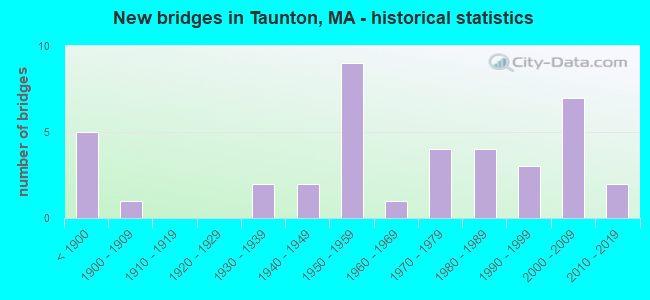
- New bridges - historical statistics
- 5Before 1900
- 11900-1909
- 21930-1939
- 21940-1949
- 91950-1959
- 11960-1969
- 41970-1979
- 41980-1989
- 31990-1999
- 72000-2009
- 22010-2019

- Reconstructed bridges - Historical Statistics
- 11930-1939
- 11940-1949
- 11950-1959
- 11960-1969
- 01970-1979
- 01980-1989
- 11990-1999
- 62000-2009


- Bridge Condition - Deck
- 26.3%Very good
- 31.6%Good
- 21.1%Satisfactory
- 21.1%Fair

- Bridge Condition - Superstructure
- 28.9%Very good
- 21.1%Good
- 26.3%Satisfactory
- 21.1%Fair
- 2.6%Poor

- Bridge Condition - Substructure
- 18.4%Very good
- 44.7%Good
- 18.4%Satisfactory
- 15.8%Fair
- 2.6%Serious

- Bridge Condition - Channel
- 24.0%Very good
- 48.0%Good
- 12.0%Satisfactory
- 16.0%Fair

- Bridge Condition - Culverts
- 50.0%Very good
- 50.0%Good
Find on map >> Show street view
Structure Number: T0100140WDOT634, Location: MP QNB 14.8 (Lat: 41.879992, Lng: -71.044794), Route carried "on" structure: City street , Year Built: 1995, Status: Open, Structure Length: 3.02m (9.91ft), Average Daily Traffic: 3,400 (year 2019), Truck Traffic: 2%, Average Future Daily Traffic: 7,581 (year 2033), Design Load: HS 20, Features Intersected: RR MBTA/CSX, Facility Carried by Structure: HWY STEVENS ST
Minimum Vertical Clearance: 30+ m (98+ ft), Kilometerpoint: 0.080, Lanes on structure: 2, Owner: State Highway Agency, Approaching Roadway Width: 8.2m (26.9ft), Skew: 2 degrees, Material/Design: Prestressed concrete, Design/Construction: Slab, Number Of Spans In Main Unit: 3, Length of Maximum Span: 11.9m (39.0ft), Curb or Sidewalk Widths: Left: 0.6m (2.0ft), Right: 1.8m (5.9ft), Curb-To-Curb Width: 8.5m (27.9ft), Out-to-Out Width: 11.1m (36.4ft)
Condition: Deck: Satisfactory, Superstructure: Fair, Substructure: Satisfactory, Operating Rating: 72.7 metric tons, Method Used To Determine Operating Rating: Load Factor (LF), Inventory Rating: 43.5 metric tons, Method Used To Determine Inventory Rating: Load Factor (LF), Structural Evaluation: Somewhat better than minimum adequacy, Deck Geometry: Meets minimum limits, Underclear: High priority of corrective action, Approach Roadway Alignment: Equal to present desirable criteria, Length Of Structure Improvement: 3.10m (10.17ft), Designated Inspection Frequency: Every 24 months, Inspection Date: January 2022, Bridge Improvement Cost: $1,352,000, Roadway Improvement Cost: $136,000, Total Project Cost: $2,029,000 ( Estimate for 2022), Deck Structure Type: Concrete Cast-file-Place, Wearing Surface/Protective System: Wearing Surface: Latex Concrete, Deck Protection: Epoxy Coated Reinforcing
Find on map >> Show street view
Structure Number: T01003AGWDOT634, Location: MP QNB 17.8 (Lat: 41.886375, Lng: -70.990819), Route carried "on" structure: City street , Year Built: 2000, Status: Open, Structure Length: 5.00m (16.40ft), Average Daily Traffic: 3,200 (year 2019), Truck Traffic: 7%, Average Future Daily Traffic: 6,949 (year 2033), Design Load: HS 20, Features Intersected: RR MBTA/CSX, Facility Carried by Structure: HWY MIDDLBORO AV
Minimum Vertical Clearance: 30+ m (98+ ft), Kilometerpoint: 0.966, Lanes on structure: 2, Owner: State Highway Agency, Approaching Roadway Width: 12.1m (39.7ft), Skew: 3 degrees, Material/Design: Steel continuous, Design/Construction: Stringer/Multi-beam, Number Of Spans In Main Unit: 3, Length of Maximum Span: 19.1m (62.7ft), Curb or Sidewalk Widths: Left: 1.8m (5.9ft), Right: 0.0m, Curb-To-Curb Width: 12.1m (39.7ft), Out-to-Out Width: 14.7m (48.2ft)
Condition: Deck: Good, Superstructure: Very good, Substructure: Very good, Operating Rating: 62.1 metric tons, Method Used To Determine Operating Rating: Load Factor (LF), Inventory Rating: 37.2 metric tons, Method Used To Determine Inventory Rating: Load Factor (LF), Structural Evaluation: Equal to present desirable criteria, Deck Geometry: Somewhat better than minimum adequacy, Underclear: High priority of corrective action, Approach Roadway Alignment: Equal to present desirable criteria, Length Of Structure Improvement: 5.10m (16.73ft), Designated Inspection Frequency: Every 24 months, Inspection Date: January 2022, Bridge Improvement Cost: $626,000, Roadway Improvement Cost: $63,000, Total Project Cost: $940,000 ( Estimate for 2022), Deck Structure Type: Concrete Cast-file-Place, Wearing Surface/Protective System: Wearing Surface: Latex Concrete, Deck Protection: Other Coated Reinforcing
Find on map >> Show street view
Structure Number: T010063NMDOTNBI, Location: .6 MI SE OF DEAN ST US 44 (Lat: 41.896733, Lng: -71.081350), Route carried "on" structure: State highway 140, Year Built: 1972, Status: Open, Structure Length: 4.11m (13.48ft), Average Daily Traffic: 29,500 (year 2020), Truck Traffic: 7%, Average Future Daily Traffic: 41,062 (year 2031), Design Load: HS 20, Features Intersected: WATER TAUNTON RIVER
Minimum Vertical Clearance: 27.43m (89.99ft), Kilometerpoint: 34.528, Lanes on structure: 2, Owner: State Highway Agency, Approaching Roadway Width: 12.2m (40.0ft), Skew: 2 degrees, Material/Design: Steel, Design/Construction: Stringer/Multi-beam, Number Of Spans In Main Unit: 2, Length of Maximum Span: 20.7m (67.9ft), Curb or Sidewalk Widths: Left: 2.1m (6.9ft), Right: 2.1m (6.9ft), Curb-To-Curb Width: 12.2m (40.0ft), Out-to-Out Width: 16.8m (55.1ft)
Condition: Deck: Good, Superstructure: Satisfactory, Substructure: Good, Channel: Good, Operating Rating: 57.9 metric tons, Method Used To Determine Operating Rating: Load Factor (LF), Inventory Rating: 34.7 metric tons, Method Used To Determine Inventory Rating: Load Factor (LF), Structural Evaluation: Equal to present minimum criteria, Deck Geometry: Somewhat better than minimum adequacy, Waterway Adequacy: Equal to present desirable criteria, Approach Roadway Alignment: Equal to present desirable criteria, Length Of Structure Improvement: 4.20m (13.78ft), Designated Inspection Frequency: Every 24 months, Underwater Inspection Frequency: Every 36 months, Inspection Date: June 2020, Underwater Inspection Date: March 2020, Bridge Improvement Cost: $476,000, Roadway Improvement Cost: $48,000, Total Project Cost: $715,000 ( Estimate for 2022), Deck Structure Type: Concrete Cast-file-Place, Wearing Surface/Protective System: Wearing Surface: Bituminous, Membrane: Built-up
Find on map >> Show street view
Structure Number: T010073K9MUNNBI, Location: AT JCT OF WATER ST (Lat: 41.886072, Lng: -71.089042), Route carried "on" structure: City street , Year Built: 1953, Status: Open, Structure Length: 3.60m (11.81ft), Average Daily Traffic: 20,600 (year 2021), Truck Traffic: 7%, Average Future Daily Traffic: 35,376 (year 2032), Design Load: H 20, Features Intersected: WATER TAUNTON RIVER, Facility Carried by Structure: HWY PLAIN ST
Minimum Vertical Clearance: 30+ m (98+ ft), Kilometerpoint: 0.032, Lanes on structure: 2, Owner: City or Municipal Highway Agency, Approaching Roadway Width: 12.2m (40.0ft), Skew: 1 degrees, Material/Design: Steel continuous, Design/Construction: Stringer/Multi-beam, Number Of Spans In Main Unit: 2, Length of Maximum Span: 17.7m (58.1ft), Curb or Sidewalk Widths: Left: 2.3m (7.5ft), Right: 2.3m (7.5ft), Curb-To-Curb Width: 12.1m (39.7ft), Out-to-Out Width: 17.5m (57.4ft)
Condition: Deck: Fair, Superstructure: Satisfactory, Substructure: Good, Channel: Good, Operating Rating: 46.6 metric tons, Method Used To Determine Operating Rating: Load Factor (LF), Inventory Rating: 29.7 metric tons, Method Used To Determine Inventory Rating: Load Factor (LF), Structural Evaluation: Equal to present minimum criteria, Deck Geometry: Somewhat better than minimum adequacy, Waterway Adequacy: Superior to present desirable criteria, Approach Roadway Alignment: Meets minimum limits, Length Of Structure Improvement: 3.70m (12.14ft), Designated Inspection Frequency: Every 24 months, Underwater Inspection Frequency: Every 36 months, Inspection Date: November 2021, Underwater Inspection Date: August 2020, Bridge Improvement Cost: $2,544,000, Roadway Improvement Cost: $255,000, Total Project Cost: $3,817,000 ( Estimate for 2022), Deck Structure Type: Concrete Cast-file-Place, Wearing Surface/Protective System: Wearing Surface: Bituminous, Membrane: Preformed Fabric
Find on map >> Show street view
Structure Number: T01008AFDMUNNBI, Location: JUST S OF ST140 (Lat: 41.896083, Lng: -71.082028), Route carried "on" structure: City street , Year Built: 2000, Status: Open, Structure Length: 2.02m (6.63ft), Average Daily Traffic: 8,400 (year 2021), Truck Traffic: 6%, Average Future Daily Traffic: 20,531 (year 2032), Design Load: HS 20, Features Intersected: WATER MILL RIVER, Facility Carried by Structure: HWY INGELL ST
Minimum Vertical Clearance: 30+ m (98+ ft), Kilometerpoint: 0.000, Lanes on structure: 2, Owner: City or Municipal Highway Agency, Approaching Roadway Width: 8.4m (27.6ft), Material/Design: Prestressed concrete, Design/Construction: Box Beam or Girders - Single/Spread, Number Of Spans In Main Unit: 1, Length of Maximum Span: 19.0m (62.3ft), Curb or Sidewalk Widths: Left: 1.5m (4.9ft), Right: 0.0m, Curb-To-Curb Width: 8.4m (27.6ft), Out-to-Out Width: 10.8m (35.4ft)
Condition: Deck: Very good, Superstructure: Very good, Substructure: Very good, Channel: Good, Operating Rating: 81.9 metric tons, Method Used To Determine Operating Rating: Load Factor (LF), Inventory Rating: 49.1 metric tons, Method Used To Determine Inventory Rating: Load Factor (LF), Structural Evaluation: Equal to present desirable criteria, Deck Geometry: High priority of replacement, Waterway Adequacy: Superior to present desirable criteria, Approach Roadway Alignment: Equal to present desirable criteria, Length Of Structure Improvement: 2.10m (6.89ft), Designated Inspection Frequency: Every 24 months, Inspection Date: October 2021, Bridge Improvement Cost: $990,000, Roadway Improvement Cost: $100,000, Total Project Cost: $1,486,000 ( Estimate for 2022), Deck Structure Type: Concrete Cast-file-Place, Wearing Surface/Protective System: Wearing Surface: Bituminous, Membrane: Built-up, Deck Protection: Epoxy Coated Reinforcing
Find on map >> Show street view
Structure Number: T0100940VDOT634, Location: .4 MI SE OF DEAN ST US 44 (Lat: 41.897772, Lng: -71.084439), Route carried "on" structure: State highway 140, Year Built: 1850, Year Reconstructed: 2005, Status: Open, Structure Length: 0.91m (2.99ft), Average Daily Traffic: 10,600 (year 2022), Truck Traffic: 6%, Average Future Daily Traffic: 31,586 (year 2033), Design Load: HS 20, Features Intersected: RR MACRR
Minimum Vertical Clearance: 30+ m (98+ ft), Kilometerpoint: 34.922, Lanes on structure: 2, Owner: State Highway Agency, Approaching Roadway Width: 7.9m (25.9ft), Material/Design: Prestressed concrete, Design/Construction: Slab, Number Of Spans In Main Unit: 1, Length of Maximum Span: 8.1m (26.6ft), Curb or Sidewalk Widths: Left: 1.6m (5.2ft), Right: 1.5m (4.9ft), Curb-To-Curb Width: 9.4m (30.8ft), Out-to-Out Width: 13.5m (44.3ft)
Condition: Deck: Very good, Superstructure: Very good, Substructure: Good, Operating Rating: 82.2 metric tons, Method Used To Determine Operating Rating: Load Factor (LF), Inventory Rating: 50.7 metric tons, Method Used To Determine Inventory Rating: Load Factor (LF), Structural Evaluation: Better than present minimum criteria, Deck Geometry: High priority of corrective action, Underclear: High priority of corrective action, Approach Roadway Alignment: Better than present minimum criteria, Length Of Structure Improvement: 1.00m (3.28ft), Designated Inspection Frequency: Every 24 months, Inspection Date: January 2022, Bridge Improvement Cost: $378,000, Roadway Improvement Cost: $38,000, Total Project Cost: $568,000 ( Estimate for 2022), Deck Structure Type: Concrete Precast Panels, Wearing Surface/Protective System: Wearing Surface: Bituminous, Membrane: Preformed Fabric, Deck Protection: Epoxy Coated Reinforcing
Find on map >> Show street view
Structure Number: T01010AKGDOT634, Location: .2 MI NW OF INGELL ST (Lat: 41.895042, Lng: -71.085736), Route carried "on" structure: City street , Year Built: 2001, Status: Open, Structure Length: 3.03m (9.94ft), Average Daily Traffic: 4,200 (year 2022), Truck Traffic: 10%, Average Future Daily Traffic: 9,476 (year 2033), Design Load: HS 20, Features Intersected: RR MACRR, Facility Carried by Structure: HWY HIGH ST
Minimum Vertical Clearance: 30+ m (98+ ft), Kilometerpoint: 0.016, Lanes on structure: 2, Owner: State Highway Agency, Approaching Roadway Width: 7.6m (24.9ft), Material/Design: Prestressed concrete, Design/Construction: Slab, Number Of Spans In Main Unit: 3, Length of Maximum Span: 9.2m (30.2ft), Curb or Sidewalk Widths: Left: 1.9m (6.2ft), Right: 1.5m (4.9ft), Curb-To-Curb Width: 7.6m (24.9ft), Out-to-Out Width: 11.8m (38.7ft)
Condition: Deck: Very good, Superstructure: Very good, Substructure: Very good, Operating Rating: 55.0 metric tons, Method Used To Determine Operating Rating: Load Factor (LF), Inventory Rating: 33.0 metric tons, Method Used To Determine Inventory Rating: Load Factor (LF), Structural Evaluation: Equal to present desirable criteria, Deck Geometry: High priority of replacement, Underclear: High priority of corrective action, Approach Roadway Alignment: Equal to present desirable criteria, Length Of Structure Improvement: 3.10m (10.17ft), Designated Inspection Frequency: Every 24 months, Inspection Date: January 2022, Bridge Improvement Cost: $1,696,000, Roadway Improvement Cost: $170,000, Total Project Cost: $2,545,000 ( Estimate for 2022), Deck Structure Type: Concrete Precast Panels, Wearing Surface/Protective System: Wearing Surface: Bituminous, Membrane: Built-up, Deck Protection: Epoxy Coated Reinforcing
Find on map >> Show street view
Structure Number: T01011ATCMUNNBI, Location: BEHIND CITY HALL (Lat: 41.899628, Lng: -71.089739), Route carried "on" structure: City street , Year Built: 2005, Status: Open, Structure Length: 2.30m (7.55ft), Average Daily Traffic: 8,600 (year 2018), Truck Traffic: 5%, Average Future Daily Traffic: 22,584 (year 2031), Design Load: HS 20, Features Intersected: WATER MILL RIVER, Facility Carried by Structure: HWY SPRING ST
Minimum Vertical Clearance: 30+ m (98+ ft), Kilometerpoint: 0.225, Lanes on structure: 2, Owner: City or Municipal Highway Agency, Approaching Roadway Width: 8.0m (26.2ft), Skew: 1 degrees, Material/Design: Prestressed concrete, Design/Construction: Box Beam or Girders - Multiple, Number Of Spans In Main Unit: 1, Length of Maximum Span: 22.0m (72.2ft), Curb or Sidewalk Widths: Left: 1.5m (4.9ft), Right: 1.5m (4.9ft), Curb-To-Curb Width: 8.5m (27.9ft), Out-to-Out Width: 12.0m (39.4ft)
Condition: Deck: Good, Superstructure: Good, Substructure: Good, Channel: Good, Operating Rating: 61.2 metric tons, Method Used To Determine Operating Rating: Load Factor (LF), Inventory Rating: 36.9 metric tons, Method Used To Determine Inventory Rating: Load Factor (LF), Structural Evaluation: Better than present minimum criteria, Deck Geometry: High priority of replacement, Waterway Adequacy: Better than present minimum criteria, Approach Roadway Alignment: Better than present minimum criteria, Length Of Structure Improvement: 2.40m (7.87ft), Designated Inspection Frequency: Every 24 months, Inspection Date: December 2020, Bridge Improvement Cost: $1,109,000, Roadway Improvement Cost: $111,000, Total Project Cost: $1,664,000 ( Estimate for 2022), Deck Structure Type: Concrete Precast Panels, Wearing Surface/Protective System: Wearing Surface: Bituminous, Membrane: Built-up, Deck Protection: Epoxy Coated Reinforcing
Find on map >> Show street view
Structure Number: T010123WFDOTNBI, Location: .1 MI S OF US 44 (Lat: 41.900125, Lng: -71.092283), Route carried "on" structure: State highway 138, Year Built: 1947, Status: Posted for load, Structure Length: 1.25m (4.10ft), Average Daily Traffic: 12,500 (year 2021), Truck Traffic: 3%, Average Future Daily Traffic: 28,427 (year 2032), Design Load: H 20, Features Intersected: WATER MILL RIVER
Minimum Vertical Clearance: 30+ m (98+ ft), Kilometerpoint: 0.000, Lanes on structure: 2, Owner: State Highway Agency, Approaching Roadway Width: 12.2m (40.0ft), Material/Design: Concrete, Design/Construction: Tee Beam, Number Of Spans In Main Unit: 1, Length of Maximum Span: 10.7m (35.1ft), Curb or Sidewalk Widths: Left: 2.7m (8.9ft), Right: 3.2m (10.5ft), Curb-To-Curb Width: 12.3m (40.4ft), Out-to-Out Width: 18.5m (60.7ft)
Condition: Deck: Fair, Superstructure: Satisfactory, Substructure: Fair, Channel: Fair, Operating Rating: 36.7 metric tons, Method Used To Determine Operating Rating: Allowable Stress (AS), Inventory Rating: 17.5 metric tons, Method Used To Determine Inventory Rating: Allowable Stress (AS), Structural Evaluation: Meets minimum limits, Deck Geometry: Somewhat better than minimum adequacy, Waterway Adequacy: Equal to present desirable criteria, Approach Roadway Alignment: Equal to present desirable criteria, Length Of Structure Improvement: 1.30m (4.27ft), Designated Inspection Frequency: Every 12 months, Underwater Inspection Frequency: Every 12 months, Inspection Date: July 2021, Underwater Inspection Date: January 2022, Bridge Improvement Cost: $945,000, Roadway Improvement Cost: $95,000, Total Project Cost: $1,418,000 ( Estimate for 2022), Deck Structure Type: Concrete Cast-file-Place, Wearing Surface/Protective System: Wearing Surface: Bituminous, Membrane: Built-up
Find on map >> Show street view
Structure Number: T010133N7DOTNBI, Location: .1 MI W OF TAUNTON GREEN (Lat: 41.900950, Lng: -71.094364), Route carried "on" structure: US 44, Year Built: 1850, Year Reconstructed: 1952, Status: Open, Structure Length: 1.43m (4.69ft), Average Daily Traffic: 15,900 (year 2019), Truck Traffic: 7%, Average Future Daily Traffic: 34,745 (year 2032), Design Load: H 20, Features Intersected: WATER MILL RIVER
Minimum Vertical Clearance: 30+ m (98+ ft), Kilometerpoint: 0.000, Lanes on structure: 2, Base Highway Network: Yes, Owner: State Highway Agency, Approaching Roadway Width: 12.2m (40.0ft), Material/Design: Concrete, Design/Construction: Tee Beam, Number Of Spans In Main Unit: 1, Length of Maximum Span: 12.8m (42.0ft), Curb or Sidewalk Widths: Left: 2.8m (9.2ft), Right: 2.5m (8.2ft), Curb-To-Curb Width: 13.1m (43.0ft), Out-to-Out Width: 18.4m (60.4ft)
Condition: Deck: Good, Superstructure: Good, Substructure: Good, Channel: Good, Operating Rating: 65.7 metric tons, Method Used To Determine Operating Rating: Allowable Stress (AS), Inventory Rating: 45.2 metric tons, Method Used To Determine Inventory Rating: Allowable Stress (AS), Structural Evaluation: Better than present minimum criteria, Deck Geometry: Somewhat better than minimum adequacy, Waterway Adequacy: Equal to present desirable criteria, Approach Roadway Alignment: Equal to present desirable criteria, Length Of Structure Improvement: 1.50m (4.92ft), Designated Inspection Frequency: Every 24 months, Inspection Date: Febuary 2021, Bridge Improvement Cost: $43,000, Roadway Improvement Cost: $5,000, Total Project Cost: $65,000 ( Estimate for 2022), Deck Structure Type: Concrete Cast-file-Place, Wearing Surface/Protective System: Wearing Surface: Bituminous, Membrane: Built-up
Find on map >> Show street view
Structure Number: T010143K3MUNNBI, Location: AT GAZZETTE BUILDING (Lat: 41.901414, Lng: -71.094883), Route carried "on" structure: City street , Year Built: 1850, Year Reconstructed: 1950, Status: Posted for load, Structure Length: 1.49m (4.89ft), Average Daily Traffic: 10,250 (year 2019), Truck Traffic: 5%, Average Future Daily Traffic: 18,004 (year 2032), Design Load: H 20, Features Intersected: WATER MILL RIVER, Facility Carried by Structure: HWY COHANNET ST
Minimum Vertical Clearance: 30+ m (98+ ft), Kilometerpoint: 0.177, Lanes on structure: 2, Owner: City or Municipal Highway Agency, Approaching Roadway Width: 12.5m (41.0ft), Skew: 2 degrees, Material/Design: Steel, Design/Construction: Stringer/Multi-beam, Number Of Spans In Main Unit: 1, Length of Maximum Span: 13.7m (44.9ft), Curb or Sidewalk Widths: Left: 3.2m (10.5ft), Right: 3.5m (11.5ft), Curb-To-Curb Width: 12.6m (41.3ft), Out-to-Out Width: 19.7m (64.6ft)
Condition: Deck: Satisfactory, Superstructure: Satisfactory, Substructure: Fair, Channel: Fair, Operating Rating: 34.0 metric tons, Method Used To Determine Operating Rating: Load Factor (LF), Inventory Rating: 20.4 metric tons, Method Used To Determine Inventory Rating: Load Factor (LF), Structural Evaluation: Somewhat better than minimum adequacy, Deck Geometry: Somewhat better than minimum adequacy, Waterway Adequacy: Superior to present desirable criteria, Approach Roadway Alignment: Equal to present desirable criteria, Length Of Structure Improvement: 1.50m (4.92ft), Designated Inspection Frequency: Every 24 months, Underwater Inspection Frequency: Every 24 months, Inspection Date: September 2021, Underwater Inspection Date: December 2020, Bridge Improvement Cost: $1,161,000, Roadway Improvement Cost: $117,000, Total Project Cost: $1,742,000 ( Estimate for 2022), Deck Structure Type: Concrete Cast-file-Place, Wearing Surface/Protective System: Wearing Surface: Bituminous, Membrane: Built-up
Find on map >> Show street view
Structure Number: T01015BHKDOTNBI, Location: .1 MI NE OF TREMONT ST (Lat: 41.903350, Lng: -71.097628), Route carried "on" structure: State highway 140, Year Built: 2016, Status: Open, Structure Length: 2.36m (7.74ft), Average Daily Traffic: 15,642 (year 2021), Truck Traffic: 5%, Design Load: HL 93, Features Intersected: WATER MILL RIVER
Minimum Vertical Clearance: 30+ m (98+ ft), Kilometerpoint: 0.000, Lanes on structure: 4, Owner: State Highway Agency, Approaching Roadway Width: 15.8m (51.8ft), Skew: 2 degrees, Material/Design: Steel, Design/Construction: Stringer/Multi-beam, Number Of Spans In Main Unit: 1, Length of Maximum Span: 22.5m (73.8ft), Curb or Sidewalk Widths: Left: 1.6m (5.2ft), Right: 3.5m (11.5ft), Curb-To-Curb Width: 15.8m (51.8ft), Out-to-Out Width: 21.8m (71.5ft)
Condition: Deck: Very good, Superstructure: Very good, Substructure: Very good, Channel: Very good, Operating Rating: 42.1 metric tons, Method Used To Determine Operating Rating: Assigned ratings based on Load and Resistance Factor Design (LRFD) reported by rating factor (RF) using HL93 loadings, Inventory Rating: 32.4 metric tons, Method Used To Determine Inventory Rating: Assigned ratings based on Load and Resistance Factor Design (LRFD) reported by rating factor (RF) using HL93 loadings, Structural Evaluation: Equal to present desirable criteria, Deck Geometry: Meets minimum limits, Waterway Adequacy: Equal to present desirable criteria, Approach Roadway Alignment: Better than present minimum criteria, Designated Inspection Frequency: Every 24 months, Inspection Date: August 2021, Deck Structure Type: Concrete Precast Panels, Wearing Surface/Protective System: Wearing Surface: Bituminous, Membrane: Built-up, Deck Protection: Epoxy Coated Reinforcing
Find on map >> Show street view
Structure Number: T010173K5MUNNBI, Location: .75 MI NE OF RTE 140 (Lat: 41.916789, Lng: -71.100783), Route carried "on" structure: City street , Year Built: 1850, Year Reconstructed: 1969, Status: Open, Structure Length: 1.34m (4.40ft), Average Daily Traffic: 3,755 (year 2017), Truck Traffic: 5%, Average Future Daily Traffic: 7,896 (year 2031), Design Load: H 20, Features Intersected: WATER MILL RIVER, Facility Carried by Structure: HWY DANFORTH ST
Minimum Vertical Clearance: 30+ m (98+ ft), Kilometerpoint: 1.384, Lanes on structure: 2, Owner: City or Municipal Highway Agency, Approaching Roadway Width: 7.9m (25.9ft), Material/Design: Prestressed concrete, Design/Construction: Slab, Number Of Spans In Main Unit: 1, Length of Maximum Span: 13.1m (43.0ft), Curb or Sidewalk Widths: Left: 1.2m (3.9ft), Right: 1.2m (3.9ft), Curb-To-Curb Width: 7.9m (25.9ft), Out-to-Out Width: 11.0m (36.1ft)
Condition: Deck: Fair, Superstructure: Fair, Substructure: Satisfactory, Channel: Good, Operating Rating: 71.4 metric tons, Method Used To Determine Operating Rating: Load Factor (LF), Inventory Rating: 48.8 metric tons, Method Used To Determine Inventory Rating: Load Factor (LF), Structural Evaluation: Somewhat better than minimum adequacy, Deck Geometry: High priority of corrective action, Waterway Adequacy: Superior to present desirable criteria, Approach Roadway Alignment: Somewhat better than minimum adequacy, Length Of Structure Improvement: 1.40m (4.59ft), Designated Inspection Frequency: Every 24 months, Underwater Inspection Frequency: Every 36 months, Inspection Date: November 2020, Underwater Inspection Date: July 2020, Bridge Improvement Cost: $605,000, Roadway Improvement Cost: $61,000, Total Project Cost: $908,000 ( Estimate for 2022), Deck Structure Type: Concrete Precast Panels, Wearing Surface/Protective System: Wearing Surface: Bituminous, Membrane: Built-up
Find on map >> Show street view
Structure Number: T010183K6MUNNBI, Location: @ REED AND BARTON (Lat: 41.918850, Lng: -71.100961), Route carried "on" structure: City street , Year Built: 1850, Year Reconstructed: 2005, Status: Open, Structure Length: 1.72m (5.64ft), Average Daily Traffic: 6,856 (year 2019), Truck Traffic: 6%, Average Future Daily Traffic: 5,054 (year 2031), Design Load: HS 20, Features Intersected: WATER MILL RIVER, Facility Carried by Structure: HWY W BRITANNIA
Minimum Vertical Clearance: 30+ m (98+ ft), Kilometerpoint: 1.400, Lanes on structure: 2, Owner: City or Municipal Highway Agency, Approaching Roadway Width: 9.7m (31.8ft), Skew: 2 degrees, Material/Design: Prestressed concrete, Design/Construction: Box Beam or Girders - Single/Spread, Number Of Spans In Main Unit: 1, Length of Maximum Span: 15.2m (49.9ft), Curb or Sidewalk Widths: Left: 1.8m (5.9ft), Right: 1.5m (4.9ft), Curb-To-Curb Width: 9.7m (31.8ft), Out-to-Out Width: 14.0m (45.9ft)
Condition: Deck: Very good, Superstructure: Very good, Substructure: Good, Channel: Good, Operating Rating: 92.3 metric tons, Method Used To Determine Operating Rating: Load Factor (LF), Inventory Rating: 57.3 metric tons, Method Used To Determine Inventory Rating: Load Factor (LF), Structural Evaluation: Better than present minimum criteria, Deck Geometry: High priority of corrective action, Waterway Adequacy: Equal to present desirable criteria, Approach Roadway Alignment: Somewhat better than minimum adequacy, Length Of Structure Improvement: 1.80m (5.91ft), Designated Inspection Frequency: Every 24 months, Inspection Date: November 2020, Bridge Improvement Cost: $628,000, Roadway Improvement Cost: $63,000, Total Project Cost: $943,000 ( Estimate for 2022), Deck Structure Type: Concrete Cast-file-Place, Wearing Surface/Protective System: Wearing Surface: Bituminous, Membrane: Built-up, Deck Protection: Epoxy Coated Reinforcing
Find on map >> Show street view
Structure Number: T01019AV4MUNNBI, Location: 0.1 MI WEST OF 3K6 (Lat: 41.918828, Lng: -71.101731), Route carried "on" structure: City street , Year Built: 2005, Status: Open, Structure Length: 0.79m (2.59ft), Average Daily Traffic: 6,856 (year 2019), Truck Traffic: 6%, Average Future Daily Traffic: 5,054 (year 2031), Design Load: HS 20, Features Intersected: WATER MILL RIVER CANAL, Facility Carried by Structure: HWY W BRITANNIA
Minimum Vertical Clearance: 30+ m (98+ ft), Kilometerpoint: 1.336, Lanes on structure: 2, Owner: City or Municipal Highway Agency, Approaching Roadway Width: 9.7m (31.8ft), Skew: 1 degrees, Material/Design: Concrete, Design/Construction: Culvert, Number Of Spans In Main Unit: 2, Length of Maximum Span: 3.4m (11.2ft), Curb or Sidewalk Widths: Left: 1.8m (5.9ft), Right: 1.8m (5.9ft), Curb-To-Curb Width: 9.7m (31.8ft), Out-to-Out Width: 15.1m (49.5ft)
Condition: Channel: Good, Culverts: Good, Operating Rating: 73.8 metric tons, Method Used To Determine Operating Rating: Load Factor (LF), Inventory Rating: 44.2 metric tons, Method Used To Determine Inventory Rating: Load Factor (LF), Structural Evaluation: Better than present minimum criteria, Deck Geometry: High priority of corrective action, Waterway Adequacy: Superior to present desirable criteria, Approach Roadway Alignment: Equal to present desirable criteria, Length Of Structure Improvement: 0.40m (1.31ft), Designated Inspection Frequency: Every 24 months, Inspection Date: November 2020, Bridge Improvement Cost: $280,000, Roadway Improvement Cost: $29,000, Total Project Cost: $421,000 ( Estimate for 2022)
Find on map >> Show street view
Structure Number: T010203K8MUNNBI, Location: AT WHITTENTON MILL (Lat: 41.923397, Lng: -71.105997), Route carried "on" structure: City street , Year Built: 1930, Year Reconstructed: 2007, Status: Open, Structure Length: 1.67m (5.48ft), Average Daily Traffic: 4,526 (year 2021), Truck Traffic: 5%, Average Future Daily Traffic: 11,529 (year 2032), Design Load: HS 25 or greater, Features Intersected: WATER MILL RIVER, Facility Carried by Structure: HWY WHITTENTN ST
Minimum Vertical Clearance: 30+ m (98+ ft), Kilometerpoint: 1.400, Lanes on structure: 2, Owner: City or Municipal Highway Agency, Approaching Roadway Width: 9.6m (31.5ft), Skew: 1 degrees, Material/Design: Prestressed concrete, Design/Construction: Box Beam or Girders - Single/Spread, Number Of Spans In Main Unit: 1, Length of Maximum Span: 15.0m (49.2ft), Curb or Sidewalk Widths: Left: 1.8m (5.9ft), Right: 1.8m (5.9ft), Curb-To-Curb Width: 9.6m (31.5ft), Out-to-Out Width: 14.0m (45.9ft)
Condition: Deck: Very good, Superstructure: Very good, Substructure: Good, Channel: Good, Operating Rating: 93.3 metric tons, Method Used To Determine Operating Rating: Load Factor (LF), Inventory Rating: 55.7 metric tons, Method Used To Determine Inventory Rating: Load Factor (LF), Structural Evaluation: Better than present minimum criteria, Deck Geometry: Meets minimum limits, Waterway Adequacy: Superior to present desirable criteria, Approach Roadway Alignment: Equal to present desirable criteria, Length Of Structure Improvement: 1.70m (5.58ft), Designated Inspection Frequency: Every 24 months, Inspection Date: August 2021, Bridge Improvement Cost: $610,000, Roadway Improvement Cost: $62,000, Total Project Cost: $916,000 ( Estimate for 2022), Deck Structure Type: Concrete Cast-file-Place, Wearing Surface/Protective System: Wearing Surface: Bituminous, Membrane: Preformed Fabric, Deck Protection: Epoxy Coated Reinforcing
Find on map >> Show street view
Structure Number: T01021B5WMUNNBI, Location: BAY STREET AT SABBATIA LA (Lat: 41.933972, Lng: -71.107875), Route carried "on" structure: City street , Year Built: 2013, Status: Open, Structure Length: 2.18m (7.15ft), Average Daily Traffic: 13,600 (year 2019), Truck Traffic: 4%, Design Load: HL 93, Features Intersected: WATER MILL RIVER, Facility Carried by Structure: HWY BAY ST
Minimum Vertical Clearance: 30+ m (98+ ft), Kilometerpoint: 2.993, Lanes on structure: 2, Owner: City or Municipal Highway Agency, Approaching Roadway Width: 9.8m (32.2ft), Material/Design: Steel, Design/Construction: Stringer/Multi-beam, Number Of Spans In Main Unit: 1, Length of Maximum Span: 18.8m (61.7ft), Curb or Sidewalk Widths: Left: 0.0m, Right: 1.6m (5.2ft), Curb-To-Curb Width: 9.8m (32.2ft), Out-to-Out Width: 12.3m (40.4ft)
Condition: Deck: Very good, Superstructure: Very good, Substructure: Very good, Channel: Very good, Operating Rating: 68.0 metric tons, Method Used To Determine Operating Rating: Load and Resistance Factor Rating (LRFR) rating reported by rating factor(RF) method using HL-93 loadings, Inventory Rating: 51.8 metric tons, Method Used To Determine Inventory Rating: Load and Resistance Factor Rating (LRFR) rating reported by rating factor(RF) method using HL-93 loadings, Structural Evaluation: Equal to present desirable criteria, Deck Geometry: Meets minimum limits, Waterway Adequacy: Equal to present minimum criteria, Approach Roadway Alignment: Meets minimum limits, Length Of Structure Improvement: 2.20m (7.22ft), Designated Inspection Frequency: Every 24 months, Inspection Date: December 2020, Bridge Improvement Cost: $758,000, Roadway Improvement Cost: $76,000, Total Project Cost: $1,138,000 ( Estimate for 2022), Deck Structure Type: Concrete Cast-file-Place, Wearing Surface/Protective System: Wearing Surface: Bituminous, Membrane: Built-up, Deck Protection: Epoxy Coated Reinforcing
Find on map >> Show street view
Structure Number: T010233KAMUNNBI, Location: 1 MI W OF RAYNHAM (Lat: 41.956222, Lng: -71.100508), Route carried "on" structure: City street , Year Built: 1943, Status: Open, Structure Length: 1.89m (6.20ft), Average Daily Traffic: 5,000 (year 2019), Truck Traffic: 7%, Average Future Daily Traffic: 13,898 (year 2031), Design Load: H 20, Features Intersected: WATER SNAKE RIVER, Facility Carried by Structure: HWY FIELD ST
Minimum Vertical Clearance: 30+ m (98+ ft), Kilometerpoint: 1.320, Lanes on structure: 2, Owner: City or Municipal Highway Agency, Approaching Roadway Width: 7.6m (24.9ft), Material/Design: Concrete continuous, Design/Construction: Slab, Number Of Spans In Main Unit: 3, Length of Maximum Span: 6.1m (20.0ft), Curb or Sidewalk Widths: Left: 0.2m (0.7ft), Right: 0.2m (0.7ft), Curb-To-Curb Width: 8.5m (27.9ft), Out-to-Out Width: 9.8m (32.2ft)
Condition: Deck: Fair, Superstructure: Fair, Substructure: Fair, Channel: Fair, Operating Rating: 40.4 metric tons, Method Used To Determine Operating Rating: Allowable Stress (AS), Inventory Rating: 24.7 metric tons, Method Used To Determine Inventory Rating: Allowable Stress (AS), Structural Evaluation: Somewhat better than minimum adequacy, Deck Geometry: Meets minimum limits, Waterway Adequacy: Equal to present minimum criteria, Approach Roadway Alignment: Equal to present desirable criteria, Length Of Structure Improvement: 1.90m (6.23ft), Designated Inspection Frequency: Every 24 months, Underwater Inspection Frequency: Every 36 months, Inspection Date: September 2020, Underwater Inspection Date: August 2020, Bridge Improvement Cost: $732,000, Roadway Improvement Cost: $74,000, Total Project Cost: $1,099,000 ( Estimate for 2022), Deck Structure Type: Concrete Cast-file-Place, Wearing Surface/Protective System: Wearing Surface: Bituminous, Membrane: Built-up
Find on map >> Show street view
Structure Number: T010243LYMUNNBI, Location: .2 MI S OF FIELD ST (Lat: 41.951378, Lng: -71.104481), Route carried "on" structure: City street , Year Built: 1967, Status: Open, Structure Length: 1.07m (3.51ft), Average Daily Traffic: 1,400 (year 2018), Truck Traffic: 9%, Average Future Daily Traffic: 2,685 (year 2031), Design Load: H 20, Features Intersected: WATER SNAKE RIVER, Facility Carried by Structure: HWY SCADDING ST
Minimum Vertical Clearance: 30+ m (98+ ft), Kilometerpoint: 2.414, Lanes on structure: 2, Owner: City or Municipal Highway Agency, Approaching Roadway Width: 4.9m (16.1ft), Material/Design: Prestressed concrete, Design/Construction: Slab, Number Of Spans In Main Unit: 1, Length of Maximum Span: 9.1m (29.9ft), Curb or Sidewalk Widths: Left: 0.3m (1.0ft), Right: 0.2m (0.7ft), Curb-To-Curb Width: 7.4m (24.3ft), Out-to-Out Width: 8.2m (26.9ft)
Condition: Deck: Fair, Superstructure: Fair, Substructure: Serious, Channel: Fair, Operating Rating: 56.9 metric tons, Method Used To Determine Operating Rating: Load Factor (LF), Inventory Rating: 34.0 metric tons, Method Used To Determine Inventory Rating: Load Factor (LF), Structural Evaluation: High priority of corrective action, Deck Geometry: Meets minimum limits, Waterway Adequacy: Meets minimum limits, Approach Roadway Alignment: High priority of corrective action, Length Of Structure Improvement: 1.10m (3.61ft), Designated Inspection Frequency: Every 6 months, Underwater Inspection Frequency: Every 12 months, Other Special Inspection Frequency: Every 6 months, Inspection Date: June 2020, Underwater Inspection Date: April 2021, Other Special Inspection Date: December 2021, Bridge Improvement Cost: $355,000, Roadway Improvement Cost: $36,000, Total Project Cost: $533,000 ( Estimate for 2022), Deck Structure Type: Concrete Precast Panels, Wearing Surface/Protective System: Wearing Surface: Bituminous
Find on map >> Show street view
Structure Number: T01027ALCMUNNBI, Location: JUST S OF JCT RTE 44 (Lat: 41.885908, Lng: -71.134064), Route carried "on" structure: City street , Year Built: 2004, Status: Open, Structure Length: 2.13m (6.99ft), Average Daily Traffic: 1,800 (year 2021), Truck Traffic: 7%, Average Future Daily Traffic: 2,053 (year 2032), Design Load: HS 20, Features Intersected: WATER THREE MILE RIVER, Facility Carried by Structure: HWY COHANNET ST
Minimum Vertical Clearance: 30+ m (98+ ft), Kilometerpoint: 0.048, Lanes on structure: 2, Owner: City or Municipal Highway Agency, Approaching Roadway Width: 7.3m (24.0ft), Material/Design: Prestressed concrete, Design/Construction: Box Beam or Girders - Single/Spread, Number Of Spans In Main Unit: 1, Length of Maximum Span: 19.1m (62.7ft), Curb or Sidewalk Widths: Left: 0.0m, Right: 1.5m (4.9ft), Curb-To-Curb Width: 7.4m (24.3ft), Out-to-Out Width: 9.9m (32.5ft)
Condition: Deck: Very good, Superstructure: Very good, Substructure: Very good, Channel: Very good, Inventory Rating: 69.5 metric tons, Method Used To Determine Inventory Rating: Load Factor (LF), Structural Evaluation: Equal to present desirable criteria, Deck Geometry: Meets minimum limits, Waterway Adequacy: Better than present minimum criteria, Approach Roadway Alignment: Superior to present desirable criteria, Length Of Structure Improvement: 2.20m (7.22ft), Designated Inspection Frequency: Every 24 months, Inspection Date: Febuary 2021, Bridge Improvement Cost: $1,247,000, Roadway Improvement Cost: $125,000, Total Project Cost: $1,871,000 ( Estimate for 2022), Deck Structure Type: Concrete Cast-file-Place, Wearing Surface/Protective System: Wearing Surface: Bituminous, Membrane: Built-up, Deck Protection: Epoxy Coated Reinforcing
Find on map >> Show street view
Structure Number: T010283N8DOTNBI, Location: .1 MI NE OF NO WALKER ST (Lat: 41.886422, Lng: -71.133411), Route carried "on" structure: US 44, Year Built: 1954, Year Reconstructed: 2011, Status: Open, Structure Length: 1.86m (6.10ft), Average Daily Traffic: 26,500 (year 2021), Truck Traffic: 10%, Average Future Daily Traffic: 36,640 (year 2032), Design Load: HS 20, Features Intersected: WATER THREE MILE RIVER
Minimum Vertical Clearance: 30+ m (98+ ft), Kilometerpoint: 19.318, Lanes on structure: 2, Base Highway Network: Yes, Owner: State Highway Agency, Approaching Roadway Width: 14.0m (45.9ft), Skew: 3 degrees, Material/Design: Steel, Design/Construction: Stringer/Multi-beam, Number Of Spans In Main Unit: 1, Length of Maximum Span: 16.6m (54.5ft), Curb or Sidewalk Widths: Left: 1.6m (5.2ft), Right: 1.6m (5.2ft), Curb-To-Curb Width: 14.0m (45.9ft), Out-to-Out Width: 18.1m (59.4ft)
Condition: Deck: Very good, Superstructure: Very good, Substructure: Good, Channel: Very good, Operating Rating: 86.5 metric tons, Method Used To Determine Operating Rating: Load Factor (LF), Inventory Rating: 51.9 metric tons, Method Used To Determine Inventory Rating: Load Factor (LF), Structural Evaluation: Better than present minimum criteria, Deck Geometry: Superior to present desirable criteria, Waterway Adequacy: Equal to present desirable criteria, Approach Roadway Alignment: Equal to present desirable criteria, Designated Inspection Frequency: Every 24 months, Inspection Date: May 2021, Deck Structure Type: Concrete Cast-file-Place, Wearing Surface/Protective System: Wearing Surface: Bituminous, Membrane: Built-up, Deck Protection: Epoxy Coated Reinforcing
Find on map >> Show street view
Structure Number: T01029ALYMUNNBI, Location: .4 MI FROM N WALKER ST (Lat: 41.896494, Lng: -71.127819), Route carried "on" structure: City street , Year Built: 2004, Status: Open, Structure Length: 2.34m (7.68ft), Average Daily Traffic: 1,500 (year 2021), Truck Traffic: 9%, Average Future Daily Traffic: 1,263 (year 2032), Design Load: HS 20, Features Intersected: WATER THREE MILE RIVER, Facility Carried by Structure: HWY FISHER ST
Minimum Vertical Clearance: 30+ m (98+ ft), Kilometerpoint: 0.547, Lanes on structure: 2, Owner: City or Municipal Highway Agency, Approaching Roadway Width: 7.2m (23.6ft), Material/Design: Prestressed concrete, Design/Construction: Box Beam or Girders - Multiple, Number Of Spans In Main Unit: 1, Length of Maximum Span: 22.6m (74.1ft), Curb or Sidewalk Widths: Left: 1.5m (4.9ft), Right: 0.0m, Curb-To-Curb Width: 7.2m (23.6ft), Out-to-Out Width: 10.8m (35.4ft)
Condition: Deck: Very good, Superstructure: Very good, Substructure: Very good, Channel: Very good, Operating Rating: 82.3 metric tons, Method Used To Determine Operating Rating: Load Factor (LF), Inventory Rating: 68.8 metric tons, Method Used To Determine Inventory Rating: Load Factor (LF), Structural Evaluation: Equal to present desirable criteria, Deck Geometry: High priority of corrective action, Waterway Adequacy: Better than present minimum criteria, Approach Roadway Alignment: Equal to present minimum criteria, Length Of Structure Improvement: 2.40m (7.87ft), Designated Inspection Frequency: Every 24 months, Inspection Date: Febuary 2021, Bridge Improvement Cost: $1,403,000, Roadway Improvement Cost: $141,000, Total Project Cost: $2,105,000 ( Estimate for 2022), Deck Structure Type: Concrete Precast Panels, Wearing Surface/Protective System: Wearing Surface: Bituminous, Membrane: Built-up, Deck Protection: Epoxy Coated Reinforcing
Find on map >> Show street view
Structure Number: T010303P7DOTNBI, Location: .2 MI E OF DUNBAR ST (Lat: 41.910219, Lng: -71.128742), Route carried "on" structure: State highway 140, Year Built: 1936, Status: Open, Structure Length: 1.59m (5.22ft), Average Daily Traffic: 17,100 (year 2021), Truck Traffic: 6%, Average Future Daily Traffic: 26,848 (year 2032), Design Load: H 20, Features Intersected: WATER THREE MILE RIVER
Minimum Vertical Clearance: 30+ m (98+ ft), Kilometerpoint: 39.122, Lanes on structure: 2, Owner: State Highway Agency, Approaching Roadway Width: 8.5m (27.9ft), Skew: 1 degrees, Material/Design: Steel, Design/Construction: Stringer/Multi-beam, Number Of Spans In Main Unit: 1, Length of Maximum Span: 14.6m (47.9ft), Curb or Sidewalk Widths: Left: 1.8m (5.9ft), Right: 1.8m (5.9ft), Curb-To-Curb Width: 12.2m (40.0ft), Out-to-Out Width: 16.9m (55.4ft)
Condition: Deck: Fair, Superstructure: Fair, Substructure: Satisfactory, Channel: Satisfactory, Operating Rating: 29.9 metric tons, Method Used To Determine Operating Rating: Load Factor (LF), Inventory Rating: 17.9 metric tons, Method Used To Determine Inventory Rating: Load Factor (LF), Structural Evaluation: Meets minimum limits, Deck Geometry: Somewhat better than minimum adequacy, Waterway Adequacy: Equal to present desirable criteria, Approach Roadway Alignment: Equal to present desirable criteria, Bridge Posting: Required (Relationship of Operating Rating to Maximum Legal Load: 0.1 - 9.9% below), Length Of Structure Improvement: 1.60m (5.25ft), Designated Inspection Frequency: Every 24 months, Underwater Inspection Frequency: Every 36 months, Inspection Date: July 2021, Underwater Inspection Date: July 2020, Bridge Improvement Cost: $1,063,000, Roadway Improvement Cost: $107,000, Total Project Cost: $1,595,000 ( Estimate for 2022), Deck Structure Type: Concrete Cast-file-Place, Wearing Surface/Protective System: Wearing Surface: Bituminous, Membrane: Built-up
Find on map >> Show street view
Structure Number: T010313K0MUNNBI, Location: .1 MI E OF RTE 140 (Lat: 41.933347, Lng: -71.154250), Route carried "on" structure: City street , Year Built: 1984, Status: Open, Structure Length: 1.80m (5.91ft), Average Daily Traffic: 10,200 (year 2019), Truck Traffic: 15%, Average Future Daily Traffic: 20,531 (year 2032), Design Load: HS 20, Features Intersected: WATER THREE MILE RIVER, Facility Carried by Structure: HWY NORTON AVE
Minimum Vertical Clearance: 30+ m (98+ ft), Kilometerpoint: 0.113, Lanes on structure: 2, Owner: City or Municipal Highway Agency, Approaching Roadway Width: 9.8m (32.2ft), Material/Design: Prestressed concrete, Design/Construction: Box Beam or Girders - Multiple, Number Of Spans In Main Unit: 1, Length of Maximum Span: 17.7m (58.1ft), Curb or Sidewalk Widths: Left: 0.5m (1.6ft), Right: 0.5m (1.6ft), Curb-To-Curb Width: 9.8m (32.2ft), Out-to-Out Width: 11.0m (36.1ft)
Condition: Deck: Good, Superstructure: Good, Substructure: Good, Channel: Good, Operating Rating: 50.5 metric tons, Method Used To Determine Operating Rating: Load Factor (LF), Inventory Rating: 30.1 metric tons, Method Used To Determine Inventory Rating: Load Factor (LF), Structural Evaluation: Better than present minimum criteria, Deck Geometry: Meets minimum limits, Waterway Adequacy: Superior to present desirable criteria, Approach Roadway Alignment: Equal to present desirable criteria, Length Of Structure Improvement: 1.90m (6.23ft), Designated Inspection Frequency: Every 24 months, Inspection Date: March 2021, Bridge Improvement Cost: $821,000, Roadway Improvement Cost: $83,000, Total Project Cost: $1,232,000 ( Estimate for 2022), Deck Structure Type: Concrete Precast Panels, Wearing Surface/Protective System: Wearing Surface: Bituminous, Membrane: Built-up
Find on map >> Show street view
Structure Number: T010323N9DOTNBI, Location: .2 MI SW OF BURT STREET (Lat: 41.877700, Lng: -71.171147), Route carried "on" structure: US 44, Year Built: 1901, Year Reconstructed: 1930, Status: Open, Structure Length: 0.67m (2.20ft), Average Daily Traffic: 15,063 (year 2019), Truck Traffic: 4%, Average Future Daily Traffic: 31,586 (year 2033), Features Intersected: WATER SEGREGANSETT RIVER
Minimum Vertical Clearance: 30+ m (98+ ft), Kilometerpoint: 16.029, Lanes on structure: 2, Base Highway Network: Yes, Owner: State Highway Agency, Approaching Roadway Width: 12.2m (40.0ft), Material/Design: Steel, Design/Construction: Stringer/Multi-beam, Number Of Spans In Main Unit: 1, Length of Maximum Span: 6.1m (20.0ft), Curb or Sidewalk Widths: Left: 0.5m (1.6ft), Right: 0.5m (1.6ft), Curb-To-Curb Width: 12.3m (40.4ft), Out-to-Out Width: 13.3m (43.6ft)
Condition: Deck: Satisfactory, Superstructure: Fair, Substructure: Fair, Channel: Satisfactory, Operating Rating: 68.6 metric tons, Method Used To Determine Operating Rating: Load Factor (LF), Inventory Rating: 41.1 metric tons, Method Used To Determine Inventory Rating: Load Factor (LF), Structural Evaluation: Somewhat better than minimum adequacy, Deck Geometry: Somewhat better than minimum adequacy, Waterway Adequacy: Equal to present desirable criteria, Approach Roadway Alignment: Equal to present desirable criteria, Length Of Structure Improvement: 0.70m (2.30ft), Designated Inspection Frequency: Every 24 months, Inspection Date: December 2021, Bridge Improvement Cost: $366,000, Roadway Improvement Cost: $37,000, Total Project Cost: $550,000 ( Estimate for 2022), Deck Structure Type: Other, Wearing Surface/Protective System: Wearing Surface: Bituminous, Membrane: Built-up
Find on map >> Show street view
Structure Number: T010453MNDOTNBI, Location: .1 MI N OF BERKLEY T.L. (Lat: 41.863956, Lng: -71.057767), Route carried "on" structure: State highway 24, Year Built: 1950, Status: Open, Structure Length: 0.94m (3.08ft), Average Daily Traffic: 48,600 (year 2019), Truck Traffic: 9%, Average Future Daily Traffic: 63,172 (year 2032), Design Load: H 20, Features Intersected: RR MACRR
Minimum Vertical Clearance: 30+ m (98+ ft), Kilometerpoint: 28.163, Lanes on structure: 4, Base Highway Network: Yes, Owner: State Highway Agency, Approaching Roadway Width: 29.3m (96.1ft), Skew: 34 degrees, Material/Design: Concrete, Design/Construction: Frame, Number Of Spans In Main Unit: 1, Length of Maximum Span: 8.0m (26.2ft), Curb-To-Curb Width: 29.3m (96.1ft), Out-to-Out Width: 41.3m (135.5ft)
Condition: Deck: Satisfactory, Superstructure: Satisfactory, Substructure: Good, Operating Rating: 66.1 metric tons, Method Used To Determine Operating Rating: Load Factor (LF), Inventory Rating: 39.7 metric tons, Method Used To Determine Inventory Rating: Load Factor (LF), Structural Evaluation: Equal to present minimum criteria, Deck Geometry: Superior to present desirable criteria, Underclear: Meets minimum limits, Approach Roadway Alignment: Equal to present desirable criteria, Length Of Structure Improvement: 1.00m (3.28ft), Designated Inspection Frequency: Every 24 months, Inspection Date: September 2021, Bridge Improvement Cost: $325,000, Roadway Improvement Cost: $33,000, Total Project Cost: $488,000 ( Estimate for 2022), Deck Structure Type: Concrete Cast-file-Place, Wearing Surface/Protective System: Wearing Surface: Bituminous, Membrane: Built-up
Find on map >> Show street view
Structure Number: T010463MPDOTNBI, Location: AT ST 140 (Lat: 41.872103, Lng: -71.055525), Route carried "on" structure: State highway 24, Year Built: 1951, Status: Open, Structure Length: 3.28m (10.76ft), Average Daily Traffic: 58,000 (year 2018), Truck Traffic: 8%, Average Future Daily Traffic: 107,550 (year 2032), Design Load: H 20, Features Intersected: ST140 COUNTY ST
Minimum Vertical Clearance: 30+ m (98+ ft), Kilometerpoint: 27.439, Lanes on structure: 6, Lanes under structure: 4, Base Highway Network: Yes, Owner: State Highway Agency, Approaching Roadway Width: 26.8m (87.9ft), Skew: 23 degrees, Material/Design: Steel, Design/Construction: Stringer/Multi-beam, Number Of Spans In Main Unit: 1, Length of Maximum Span: 31.4m (103.0ft), Curb or Sidewalk Widths: Left: 0.1m (0.3ft), Right: 0.8m (2.6ft), Curb-To-Curb Width: 22.5m (73.8ft), Out-to-Out Width: 28.9m (94.8ft)
Condition: Deck: Fair, Superstructure: Poor, Substructure: Fair, Operating Rating: 36.9 metric tons, Method Used To Determine Operating Rating: Load Factor (LF), Inventory Rating: 22.1 metric tons, Method Used To Determine Inventory Rating: Load Factor (LF), Structural Evaluation: Meets minimum limits, Deck Geometry: High priority of replacement, Underclear: Somewhat better than minimum adequacy, Approach Roadway Alignment: Equal to present desirable criteria, Length Of Structure Improvement: 4.20m (13.78ft), Designated Inspection Frequency: Every 12 months, Other Special Inspection Frequency: Every 12 months, Inspection Date: December 2021, Other Special Inspection Date: December 2021, Bridge Improvement Cost: $7,898,000, Roadway Improvement Cost: $790,000, Total Project Cost: $11,848,000 ( Estimate for 2022), Deck Structure Type: Concrete Cast-file-Place, Wearing Surface/Protective System: Wearing Surface: Bituminous, Membrane: Built-up
Find on map >> Show street view
Structure Number: T010473MQDOTNBI, Location: CSX MP QNB 14.29 N OF 140 (Lat: 41.875739, Lng: -71.054497), Route carried "on" structure: State highway 24, Year Built: 1950, Status: Open, Structure Length: 0.85m (2.79ft), Average Daily Traffic: 69,622 (year 2019), Truck Traffic: 5%, Average Future Daily Traffic: 91,599 (year 2032), Design Load: H 20, Features Intersected: RR MBTA/CSX
Minimum Vertical Clearance: 30+ m (98+ ft), Kilometerpoint: 27.921, Lanes on structure: 6, Base Highway Network: Yes, Owner: State Highway Agency, Approaching Roadway Width: 26.8m (87.9ft), Skew: 34 degrees, Material/Design: Concrete, Design/Construction: Frame, Number Of Spans In Main Unit: 1, Length of Maximum Span: 7.3m (24.0ft), Curb-To-Curb Width: 26.8m (87.9ft), Out-to-Out Width: 37.8m (124.0ft)
Condition: Deck: Satisfactory, Superstructure: Satisfactory, Substructure: Good, Operating Rating: 61.6 metric tons, Method Used To Determine Operating Rating: Load Factor (LF), Inventory Rating: 35.6 metric tons, Method Used To Determine Inventory Rating: Load Factor (LF), Structural Evaluation: Equal to present minimum criteria, Deck Geometry: Somewhat better than minimum adequacy, Underclear: High priority of corrective action, Approach Roadway Alignment: Equal to present desirable criteria, Length Of Structure Improvement: 0.90m (2.95ft), Designated Inspection Frequency: Every 24 months, Inspection Date: September 2021, Bridge Improvement Cost: $230,000, Roadway Improvement Cost: $24,000, Total Project Cost: $346,000 ( Estimate for 2022), Deck Structure Type: Concrete Cast-file-Place, Wearing Surface/Protective System: Wearing Surface: Bituminous, Membrane: Built-up
Find on map >> Show street view
Structure Number: T010483WYDOTNBI, Location: .8 MI N OF ST 140 (Lat: 41.883219, Lng: -71.052403), Route carried "on" structure: City street , Year Built: 1951, Status: Open, Structure Length: 5.06m (16.60ft), Average Daily Traffic: 11,700 (year 2019), Truck Traffic: 4%, Average Future Daily Traffic: 22,110 (year 2032), Design Load: H 20, Features Intersected: ST 24, Facility Carried by Structure: HWY HART ST
Minimum Vertical Clearance: 30+ m (98+ ft), Kilometerpoint: 0.000, Lanes on structure: 2, Lanes under structure: 4, Owner: State Highway Agency, Approaching Roadway Width: 9.1m (29.9ft), Material/Design: Steel, Design/Construction: Stringer/Multi-beam, Number Of Spans In Main Unit: 2, Length of Maximum Span: 24.4m (80.1ft), Curb or Sidewalk Widths: Left: 0.0m, Right: 1.5m (4.9ft), Curb-To-Curb Width: 12.2m (40.0ft), Out-to-Out Width: 14.8m (48.6ft)
Condition: Deck: Satisfactory, Superstructure: Fair, Substructure: Satisfactory, Operating Rating: 39.9 metric tons, Method Used To Determine Operating Rating: Allowable Stress (AS), Inventory Rating: 21.0 metric tons, Method Used To Determine Inventory Rating: Allowable Stress (AS), Structural Evaluation: Somewhat better than minimum adequacy, Deck Geometry: Somewhat better than minimum adequacy, Underclear: High priority of corrective action, Approach Roadway Alignment: Equal to present desirable criteria, Length Of Structure Improvement: 5.10m (16.73ft), Designated Inspection Frequency: Every 24 months, Inspection Date: March 2021, Bridge Improvement Cost: $2,965,000, Roadway Improvement Cost: $297,000, Total Project Cost: $4,448,000 ( Estimate for 2022), Deck Structure Type: Concrete Cast-file-Place, Wearing Surface/Protective System: Wearing Surface: Bituminous, Membrane: Built-up
Find on map >> Show street view
Structure Number: T010503NKDOTNBI, Location: 3.2 MI SO OF RT 24 (Lat: 41.840958, Lng: -71.008800), Route carried "on" structure: State highway 140, Year Built: 1959, Status: Open, Structure Length: 1.95m (6.40ft), Average Daily Traffic: 14,808 (year 2021), Truck Traffic: 6%, Average Future Daily Traffic: 29,533 (year 2032), Design Load: H 20, Features Intersected: ST 79 MYRICKS ST
Minimum Vertical Clearance: 30+ m (98+ ft), Kilometerpoint: 25.715, Lanes on structure: 2, Lanes under structure: 2, Base Highway Network: Yes, Owner: State Highway Agency, Approaching Roadway Width: 13.4m (44.0ft), Skew: 2 degrees, Material/Design: Steel, Design/Construction: Stringer/Multi-beam, Number Of Spans In Main Unit: 1, Length of Maximum Span: 17.7m (58.1ft), Curb or Sidewalk Widths: Left: 1.1m (3.6ft), Right: 1.1m (3.6ft), Curb-To-Curb Width: 13.4m (44.0ft), Out-to-Out Width: 15.5m (50.9ft)
Condition: Deck: Satisfactory, Superstructure: Satisfactory, Substructure: Satisfactory, Operating Rating: 55.9 metric tons, Method Used To Determine Operating Rating: Load Factor (LF), Inventory Rating: 33.5 metric tons, Method Used To Determine Inventory Rating: Load Factor (LF), Structural Evaluation: Equal to present minimum criteria, Deck Geometry: Superior to present desirable criteria, Underclear: Meets minimum limits, Approach Roadway Alignment: Equal to present desirable criteria, Length Of Structure Improvement: 2.00m (6.56ft), Designated Inspection Frequency: Every 24 months, Inspection Date: October 2021, Bridge Improvement Cost: $244,000, Roadway Improvement Cost: $25,000, Total Project Cost: $367,000 ( Estimate for 2022), Deck Structure Type: Concrete Cast-file-Place, Wearing Surface/Protective System: Wearing Surface: Bituminous, Membrane: Built-up
Find on map >> Show street view
Structure Number: T010513YCDOTNBI, Location: .9 MI NW OF LAKEVILLE TL (Lat: 41.847783, Lng: -71.019083), Route carried "on" structure: Other road , Year Built: 1959, Year Reconstructed: 2012, Status: Open, Structure Length: 5.09m (16.70ft), Average Daily Traffic: 1,900 (year 2020), Truck Traffic: 7%, Average Future Daily Traffic: 2,685 (year 2031), Design Load: HS 20, Features Intersected: ST140 NB, Facility Carried by Structure: HWY HOLLOWAY ST
Minimum Vertical Clearance: 30+ m (98+ ft), Kilometerpoint: 0.016, Lanes on structure: 2, Lanes under structure: 2, Owner: State Highway Agency, Approaching Roadway Width: 9.8m (32.2ft), Material/Design: Steel, Design/Construction: Stringer/Multi-beam, Number Of Spans In Main Unit: 3, Length of Maximum Span: 18.6m (61.0ft), Curb or Sidewalk Widths: Left: 0.0m, Right: 1.7m (5.6ft), Curb-To-Curb Width: 10.1m (33.1ft), Out-to-Out Width: 12.6m (41.3ft)
Condition: Deck: Good, Superstructure: Good, Substructure: Good, Operating Rating: 86.8 metric tons, Method Used To Determine Operating Rating: Load Factor (LF), Inventory Rating: 52.0 metric tons, Method Used To Determine Inventory Rating: Load Factor (LF), Structural Evaluation: Better than present minimum criteria, Deck Geometry: Somewhat better than minimum adequacy, Underclear: High priority of corrective action, Approach Roadway Alignment: Equal to present desirable criteria, Length Of Structure Improvement: 5.10m (16.73ft), Designated Inspection Frequency: Every 24 months, Inspection Date: October 2020, Bridge Improvement Cost: $1,587,000, Roadway Improvement Cost: $159,000, Total Project Cost: $2,381,000 ( Estimate for 2022), Deck Structure Type: Concrete Precast Panels, Wearing Surface/Protective System: Wearing Surface: Bituminous, Membrane: Built-up, Deck Protection: Epoxy Coated Reinforcing
Find on map >> Show street view
Structure Number: T010523X8DOTNBI, Location: .5 MI S OF ST 24 (Lat: 41.867156, Lng: -71.048239), Route carried "on" structure: City street , Year Built: 1959, Year Reconstructed: 2004, Status: Open, Structure Length: 4.88m (16.01ft), Average Daily Traffic: 8,200 (year 2018), Truck Traffic: 6%, Average Future Daily Traffic: 20,531 (year 2032), Design Load: H 20, Features Intersected: ST140, Facility Carried by Structure: HWY STEVENS ST
Minimum Vertical Clearance: 30+ m (98+ ft), Kilometerpoint: 0.000, Lanes on structure: 4, Lanes under structure: 5, Owner: State Highway Agency, Approaching Roadway Width: 14.0m (45.9ft), Material/Design: Steel, Design/Construction: Stringer/Multi-beam, Number Of Spans In Main Unit: 2, Length of Maximum Span: 24.1m (79.1ft), Curb or Sidewalk Widths: Left: 0.0m, Right: 1.5m (4.9ft), Curb-To-Curb Width: 14.0m (45.9ft), Out-to-Out Width: 17.2m (56.4ft)
Condition: Deck: Good, Superstructure: Fair, Substructure: Fair, Operating Rating: 77.9 metric tons, Method Used To Determine Operating Rating: Load Factor (LF), Inventory Rating: 46.6 metric tons, Method Used To Determine Inventory Rating: Load Factor (LF), Structural Evaluation: Somewhat better than minimum adequacy, Deck Geometry: High priority of replacement, Underclear: High priority of corrective action, Approach Roadway Alignment: Equal to present desirable criteria, Length Of Structure Improvement: 4.90m (16.08ft), Designated Inspection Frequency: Every 24 months, Inspection Date: Febuary 2021, Bridge Improvement Cost: $3,311,000, Roadway Improvement Cost: $332,000, Total Project Cost: $4,967,000 ( Estimate for 2022), Deck Structure Type: Concrete Cast-file-Place, Wearing Surface/Protective System: Wearing Surface: Bituminous, Membrane: Built-up, Deck Protection: Epoxy Coated Reinforcing
Find on map >> Show street view
Structure Number: T010563NLDOTNBI, Location: 3.2 MI. SO. OF ROUTE 24 (Lat: 41.840803, Lng: -71.009331), Route carried "on" structure: State highway 140, Year Built: 1970, Status: Open, Structure Length: 2.93m (9.61ft), Average Daily Traffic: 15,100 (year 2019), Truck Traffic: 4%, Average Future Daily Traffic: 12,950 (year 2032), Design Load: H 20, Features Intersected: ST 79 MYRICKS ST
Minimum Vertical Clearance: 30+ m (98+ ft), Kilometerpoint: 25.715, Lanes on structure: 2, Lanes under structure: 2, Base Highway Network: Yes, Owner: State Highway Agency, Approaching Roadway Width: 11.6m (38.1ft), Material/Design: Steel, Design/Construction: Stringer/Multi-beam, Number Of Spans In Main Unit: 1, Length of Maximum Span: 28.3m (92.8ft), Curb or Sidewalk Widths: Left: 0.6m (2.0ft), Right: 0.6m (2.0ft), Curb-To-Curb Width: 11.6m (38.1ft), Out-to-Out Width: 12.8m (42.0ft)
Condition: Deck: Good, Superstructure: Good, Substructure: Good, Operating Rating: 64.5 metric tons, Method Used To Determine Operating Rating: Load Factor (LF), Inventory Rating: 38.6 metric tons, Method Used To Determine Inventory Rating: Load Factor (LF), Structural Evaluation: Better than present minimum criteria, Deck Geometry: Equal to present minimum criteria, Underclear: Meets minimum limits, Approach Roadway Alignment: Equal to present desirable criteria, Length Of Structure Improvement: 3.00m (9.84ft), Designated Inspection Frequency: Every 24 months, Inspection Date: October 2021, Bridge Improvement Cost: $340,000, Roadway Improvement Cost: $35,000, Total Project Cost: $511,000 ( Estimate for 2022), Deck Structure Type: Concrete Cast-file-Place, Wearing Surface/Protective System: Wearing Surface: Bituminous, Membrane: Built-up
Find on map >> Show street view
Structure Number: T010573YDDOTNBI, Location: .9 MI NW OF LAKEVILLE T.L (Lat: 41.847697, Lng: -71.019250), Route carried "on" structure: Other road , Year Built: 1970, Year Reconstructed: 2012, Status: Open, Structure Length: 2.90m (9.51ft), Average Daily Traffic: 1,900 (year 2020), Truck Traffic: 7%, Average Future Daily Traffic: 2,527 (year 2032), Design Load: H 20, Features Intersected: ST140 SB, Facility Carried by Structure: HWY HOLLOWAY ST
Minimum Vertical Clearance: 30+ m (98+ ft), Kilometerpoint: 0.016, Lanes on structure: 2, Lanes under structure: 2, Owner: State Highway Agency, Approaching Roadway Width: 9.8m (32.2ft), Material/Design: Steel, Design/Construction: Stringer/Multi-beam, Number Of Spans In Main Unit: 1, Length of Maximum Span: 27.4m (89.9ft), Curb or Sidewalk Widths: Left: 1.7m (5.6ft), Right: 0.0m, Curb-To-Curb Width: 9.8m (32.2ft), Out-to-Out Width: 12.6m (41.3ft)
Condition: Deck: Good, Superstructure: Good, Substructure: Good, Operating Rating: 65.3 metric tons, Method Used To Determine Operating Rating: Load Factor (LF), Inventory Rating: 39.1 metric tons, Method Used To Determine Inventory Rating: Load Factor (LF), Structural Evaluation: Better than present minimum criteria, Deck Geometry: Somewhat better than minimum adequacy, Underclear: Equal to present minimum criteria, Approach Roadway Alignment: Equal to present desirable criteria, Length Of Structure Improvement: 3.00m (9.84ft), Designated Inspection Frequency: Every 24 months, Inspection Date: October 2020, Bridge Improvement Cost: $1,019,000, Roadway Improvement Cost: $102,000, Total Project Cost: $1,529,000 ( Estimate for 2022), Deck Structure Type: Concrete Cast-file-Place, Wearing Surface/Protective System: Wearing Surface: Bituminous, Membrane: Built-up
Find on map >> Show street view
Structure Number: T010583YFDOTNBI, Location: .4 MI E OF NORTON T.L. (Lat: 41.962442, Lng: -71.123450), Route carried "on" structure: City street , Year Built: 1980, Status: Open, Structure Length: 7.44m (24.41ft), Average Daily Traffic: 4,700 (year 2020), Truck Traffic: 6%, Average Future Daily Traffic: 38,535 (year 2031), Design Load: H 20, Features Intersected: I 495, Facility Carried by Structure: HWY BAY ST
Minimum Vertical Clearance: 30+ m (98+ ft), Kilometerpoint: 0.000, Lanes on structure: 5, Lanes under structure: 6, Owner: State Highway Agency, Approaching Roadway Width: 25.9m (85.0ft), Skew: 24 degrees, Material/Design: Steel continuous, Design/Construction: Stringer/Multi-beam, Number Of Spans In Main Unit: 2, Length of Maximum Span: 36.0m (118.1ft), Curb or Sidewalk Widths: Left: 0.2m (0.7ft), Right: 1.5m (4.9ft), Curb-To-Curb Width: 25.8m (84.6ft), Out-to-Out Width: 28.2m (92.5ft)
Condition: Deck: Fair, Superstructure: Satisfactory, Substructure: Satisfactory, Operating Rating: 77.3 metric tons, Method Used To Determine Operating Rating: Load Factor (LF), Inventory Rating: 46.3 metric tons, Method Used To Determine Inventory Rating: Load Factor (LF), Structural Evaluation: Equal to present minimum criteria, Deck Geometry: Superior to present desirable criteria, Underclear: High priority of corrective action, Approach Roadway Alignment: Equal to present desirable criteria, Length Of Structure Improvement: 7.50m (24.61ft), Designated Inspection Frequency: Every 24 months, Inspection Date: December 2020, Bridge Improvement Cost: $3,988,000, Roadway Improvement Cost: $399,000, Total Project Cost: $5,983,000 ( Estimate for 2022), Deck Structure Type: Concrete Cast-file-Place, Wearing Surface/Protective System: Wearing Surface: Bituminous, Membrane: Built-up
Find on map >> Show street view
Structure Number: T010593RVDOTNBI, Location: 1.7 MI E OF NORTON TL (Lat: 41.960778, Lng: -71.099694), Route carried "on" structure: Interstate 495, Year Built: 1980, Status: Open, Structure Length: 4.88m (16.01ft), Average Daily Traffic: 48,122 (year 2019), Truck Traffic: 5%, Average Future Daily Traffic: 63,962 (year 2031), Design Load: HS 20, Features Intersected: WATER SNAKE RIVER
Minimum Vertical Clearance: 30+ m (98+ ft), Kilometerpoint: 37.530, Lanes on structure: 3, Base Highway Network: Yes, Owner: State Highway Agency, Approaching Roadway Width: 16.5m (54.1ft), Material/Design: Steel, Design/Construction: Stringer/Multi-beam, Number Of Spans In Main Unit: 1, Length of Maximum Span: 47.2m (154.9ft), Curb-To-Curb Width: 16.3m (53.5ft), Out-to-Out Width: 17.2m (56.4ft)
Condition: Deck: Good, Superstructure: Good, Substructure: Good, Channel: Good, Operating Rating: 75.7 metric tons, Method Used To Determine Operating Rating: Load Factor (LF), Inventory Rating: 45.4 metric tons, Method Used To Determine Inventory Rating: Load Factor (LF), Structural Evaluation: Better than present minimum criteria, Deck Geometry: Equal to present minimum criteria, Waterway Adequacy: Superior to present desirable criteria, Approach Roadway Alignment: Superior to present desirable criteria, Length Of Structure Improvement: 4.90m (16.08ft), Designated Inspection Frequency: Every 24 months, Inspection Date: April 2020, Bridge Improvement Cost: $971,000, Roadway Improvement Cost: $98,000, Total Project Cost: $1,457,000 ( Estimate for 2022), Deck Structure Type: Concrete Cast-file-Place, Wearing Surface/Protective System: Wearing Surface: Bituminous, Membrane: Built-up, Deck Protection: Epoxy Coated Reinforcing