Cummington, Massachusetts
Submit your own pictures of this town and show them to the world
Detailed information about poverty and poor residents in Cummington, MA
Full-time law enforcement employees in 2018, including police officers: 1 (1 officers - 1 male; 0 female).
| Officers per 1,000 residents here: | 1.13 |
| Massachusetts average: | 2.60 |
 Recent articles from our blog. Our writers, many of them Ph.D. graduates or candidates, create easy-to-read articles on a wide variety of topics.
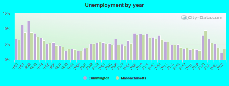
| Here: | 2.2% |
| Massachusetts: | 3.5% |

- Educational services (18.3%)
- Health care (13.4%)
- Construction (6.6%)
- Agriculture, forestry, fishing & hunting (5.8%)
- Professional, scientific, technical services (4.9%)
- Public administration (4.7%)
- Administrative & support & waste management services (4.5%)
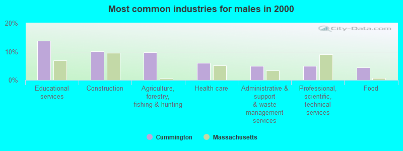
- Educational services (13.8%)
- Construction (10.2%)
- Agriculture, forestry, fishing & hunting (9.8%)
- Health care (6.1%)
- Administrative & support & waste management services (4.9%)
- Professional, scientific, technical services (4.9%)
- Food (4.5%)
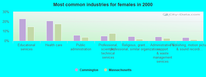
- Educational services (22.9%)
- Health care (20.8%)
- Public administration (5.8%)
- Professional, scientific, technical services (5.0%)
- Religious, grantmaking, civic, professional, similar organizations (4.6%)
- Administrative & support & waste management services (4.2%)
- Publishing, motion picture & sound recording industries (3.3%)

- Other production occupations, including supervisors (4.9%)
- Nursing, psychiatric, and home health aides (4.7%)
- Preschool, kindergarten, elementary, and middle school teachers (4.1%)
- Other management occupations, except farmers and farm managers (3.9%)
- Other sales and related occupations, including supervisors (3.9%)
- Secretaries and administrative assistants (3.3%)
- Operations specialties managers, except financial managers (3.1%)

- Engineers (4.9%)
- Farmers and farm managers (4.5%)
- Other management occupations, except farmers and farm managers (4.5%)
- Driver/sales workers and truck drivers (4.5%)
- Retail sales workers, except cashiers (4.1%)
- Other sales and related occupations, including supervisors (4.1%)
- Other production occupations, including supervisors (4.1%)

- Nursing, psychiatric, and home health aides (6.7%)
- Other production occupations, including supervisors (5.8%)
- Preschool, kindergarten, elementary, and middle school teachers (5.8%)
- Secretaries and administrative assistants (5.8%)
- Librarians, curators, and archivists (5.0%)
- Other teachers, instructors, education, training, and library occupations (4.2%)
- Other sales and related occupations, including supervisors (3.8%)
Average climate in Cummington, Massachusetts
Based on data reported by over 4,000 weather stations


(lower is better)

Air Quality Index (AQI) level in 2022 was 69.0. This is about average.
| City: | 69.0 |
| U.S.: | 72.6 |

Ozone [ppb] level in 2022 was 25.9. This is better than average. Closest monitor was 14.4 miles away from the city center.
| City: | 25.9 |
| U.S.: | 33.3 |

Particulate Matter (PM2.5) [µg/m3] level in 2022 was 6.62. This is better than average. Closest monitor was 16.4 miles away from the city center.
| City: | 6.62 |
| U.S.: | 8.11 |
Tornado activity:
Cummington-area historical tornado activity is above Massachusetts state average. It is 14% smaller than the overall U.S. average.
On 5/29/1995, a category F4 (max. wind speeds 207-260 mph) tornado 24.1 miles away from the Cummington town center killed 3 people and injured 24 people and caused between $5,000,000 and $50,000,000 in damages.
On 8/28/1973, a category F4 tornado 25.8 miles away from the town center killed 4 people and injured 36 people and caused between $5,000,000 and $50,000,000 in damages.
Earthquake activity:
Cummington-area historical earthquake activity is significantly above Massachusetts state average. It is 69% smaller than the overall U.S. average.On 10/7/1983 at 10:18:46, a magnitude 5.3 (5.1 MB, 5.3 LG, 5.1 ML, Class: Moderate, Intensity: VI - VII) earthquake occurred 125.5 miles away from Cummington center
On 4/20/2002 at 10:50:47, a magnitude 5.3 (5.3 ML, Depth: 3.0 mi) earthquake occurred 146.9 miles away from the city center
On 4/20/2002 at 10:50:47, a magnitude 5.2 (5.2 MB, 4.2 MS, 5.2 MW, 5.0 MW) earthquake occurred 145.5 miles away from Cummington center
On 1/19/1982 at 00:14:42, a magnitude 4.7 (4.5 MB, 4.7 MD, 4.5 LG, Class: Light, Intensity: IV - V) earthquake occurred 97.8 miles away from the city center
On 10/16/2012 at 23:12:25, a magnitude 4.7 (4.7 ML, Depth: 10.0 mi) earthquake occurred 138.6 miles away from the city center
On 6/17/1991 at 08:53:16, a magnitude 4.1 (4.0 MB, 4.0 LG, Depth: 3.1 mi) earthquake occurred 90.4 miles away from Cummington center
Magnitude types: regional Lg-wave magnitude (LG), body-wave magnitude (MB), duration magnitude (MD), local magnitude (ML), surface-wave magnitude (MS), moment magnitude (MW)
Natural disasters:
The number of natural disasters in Hampshire County (21) is greater than the US average (15).Major Disasters (Presidential) Declared: 10
Emergencies Declared: 10
Causes of natural disasters: Floods: 5, Snowstorms: 5, Storms: 5, Hurricanes: 4, Winter Storms: 4, Blizzards: 2, Snows: 2, Snowfall: 1, Tropical Storm: 1, Wind: 1, Other: 1 (Note: some incidents may be assigned to more than one category).

Hospitals and medical centers near Cummington:
- OVERLOOK AT NORTHAMPTON (Nursing Home, about 13 miles away; LEEDS, MA)
- CRANEVILLE PLACE AT DALTON (Nursing Home, about 14 miles away; DALTON, MA)
- LINDA MANOR EXTENDED CARE FACILITY (Nursing Home, about 14 miles away; LEEDS, MA)
- NORTHAMPTON VA MEDICAL CENTER (Hospital, Acute Care - Veterans Administration, about 15 miles away; LEEDS, MA)
- ANCHORAGE NURSING HOME (Nursing Home, about 15 miles away; SHELBURNE, MA)
- NORTHERN BERKSHIRE COMPREHENSIVE CARE (Home Health Center, about 16 miles away; ADAMS, MA)
- HOSPICE OF N BERKSHIRE INC (Hospital, about 16 miles away; ADAMS, MA)
Colleges/universities with over 2000 students nearest to Cummington:
- Smith College (about 18 miles; Northampton, MA; Full-time enrollment: 3,549)
- University of Massachusetts-Amherst (about 21 miles; Amherst, MA; FT enrollment: 26,583)
- Williams College (about 23 miles; Williamstown, MA; FT enrollment: 2,141)
- Mount Holyoke College (about 23 miles; South Hadley, MA; FT enrollment: 2,573)
- Holyoke Community College (about 24 miles; Holyoke, MA; FT enrollment: 4,911)
- Westfield State University (about 24 miles; Westfield, MA; FT enrollment: 5,548)
- Springfield Technical Community College (about 31 miles; Springfield, MA; FT enrollment: 4,750)
Private high school in Cummington:
Public elementary/middle school in Cummington:
- BERKSHIRE TRAIL ELEMENTARY (Students: 112, Location: 2 MAIN STREET, Grades: PK-5)
Points of interest:
Notable locations in Cummington: Joyner Dairy Farm (A), Berkshire Show Basin Ski Area (B), Bryant Homestead (C), Cummington Fairgrounds (D), Jordansville (E), Cummington Fire Department (F), Kingman Tavern Museum (G), Cummington Town Hall (H). Display/hide their locations on the map
Cemeteries: North Cemetery (1), Bryant Cemetery (2), Dawes Cemetery (3). Display/hide their locations on the map
Streams, rivers, and creeks: Westfield Brook (A), Mill Brook (B), Meadow Brook (C), Bartlett Brook (D), Swift River (E), Roaring Brook (F), Rivulet Brook (G), Powell Brook (H), Wolf Brook (I). Display/hide their locations on the map
Park in Cummington: Cummington Farm Village (1). Display/hide its location on the map
Birthplace of: Henry L. Dawes - Politician and lawyer, William Cullen Bryant - (1794-1878), poet, Luther Bradish - Politician, Worcester Reed Warner - Engineer.
Drinking water stations with addresses in Cummington and their reported violations in the past:
CUMMINGTON WATER DEPT (Population served: 265, Groundwater):Past health violations:WEST CUMMINGTON WATER DEPT (Population served: 94, Groundwater):Past monitoring violations:
- MCL, Monthly (TCR) - In APR-2014, Contaminant: Coliform. Follow-up actions: St AO (w/o penalty) issued (MAY-09-2014)
- 40 regular monitoring violations
Past monitoring violations:
- Follow-up Or Routine LCR Tap M/R - In JAN-01-2011, Contaminant: Lead and Copper Rule. Follow-up actions: St AO (w/o penalty) issued (FEB-24-2014)
- 39 regular monitoring violations
| This town: | 2.2 people |
| Massachusetts: | 2.5 people |
| This town: | 56.9% |
| Whole state: | 63.0% |
| This town: | 9.2% |
| Whole state: | 7.0% |
Likely homosexual households (counted as self-reported same-sex unmarried-partner households)
- Lesbian couples: 2.5% of all households
- Gay men: 0.2% of all households
| This town: | 6.6% |
| Whole state: | 9.3% |
| This town: | 3.0% |
| Whole state: | 4.4% |


| Here: | 10.3 |
| Massachusetts average: | 13.1 |
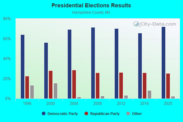
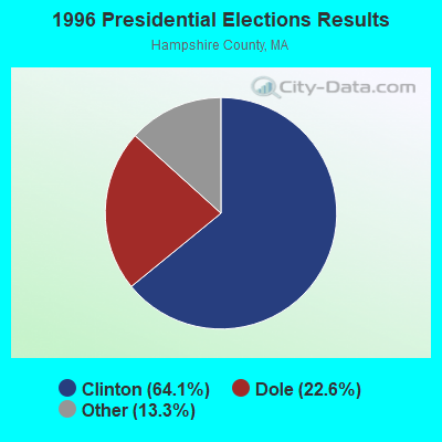
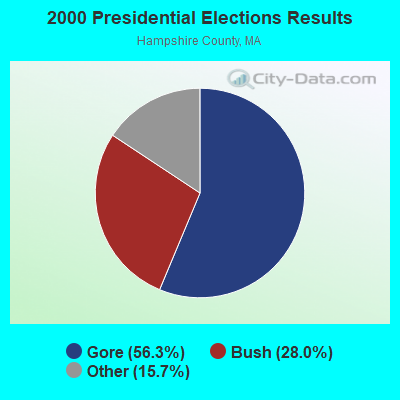
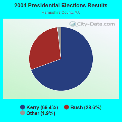
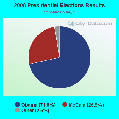
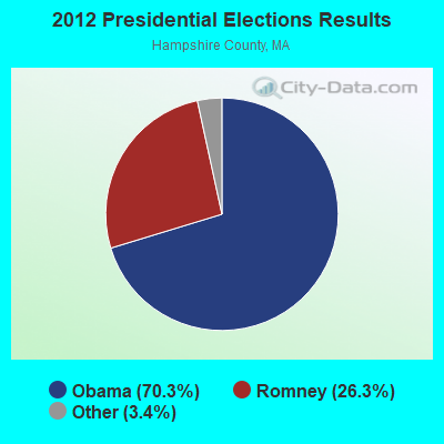
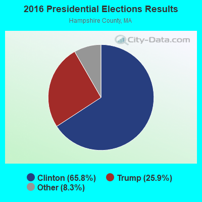
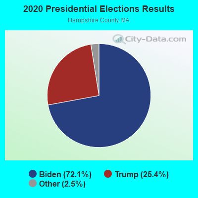
Graphs represent county-level data. Detailed 2008 Election Results
Religion statistics for Cummington, MA (based on Hampshire County data)
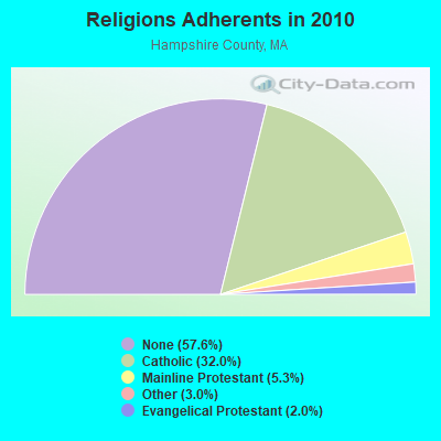
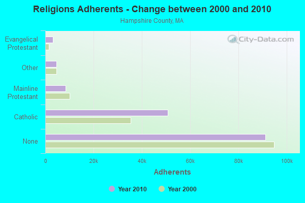
| Religion | Adherents | Congregations |
|---|---|---|
| Catholic | 50,643 | 22 |
| Mainline Protestant | 8,454 | 45 |
| Other | 4,722 | 27 |
| Evangelical Protestant | 3,128 | 22 |
| Black Protestant | 29 | 1 |
| None | 91,104 | - |
Food Environment Statistics:
| Here: | 2.07 / 10,000 pop. |
| State: | 1.98 / 10,000 pop. |
| Hampshire County: | 0.06 / 10,000 pop. |
| Massachusetts: | 0.05 / 10,000 pop. |
| This county: | 1.55 / 10,000 pop. |
| State: | 2.22 / 10,000 pop. |
| Hampshire County: | 1.94 / 10,000 pop. |
| Massachusetts: | 1.77 / 10,000 pop. |
| Hampshire County: | 10.22 / 10,000 pop. |
| State: | 8.76 / 10,000 pop. |
| Hampshire County: | 7.3% |
| Massachusetts: | 8.1% |
| Here: | 21.7% |
| Massachusetts: | 22.5% |
| Hampshire County: | 12.3% |
| State: | 16.5% |
Strongest AM radio stations in Cummington:
- WNNZ (640 AM; 50 kW; WESTFIELD, MA; Owner: CLEAR CHANNEL BROADCASTING LICENSES, INC.)
- WCRN (830 AM; 50 kW; WORCESTER, MA; Owner: CARTER BROADCASTING CORPORATION)
- WTIC (1080 AM; 50 kW; HARTFORD, CT; Owner: INFINITY RADIO OPERATIONS INC.)
- WIZZ (1520 AM; daytime; 10 kW; GREENFIELD, MA; Owner: P. & M. RADIO, LLC)
- WHYN (560 AM; 5 kW; SPRINGFIELD, MA; Owner: CLEAR CHANNEL BROADCASTING LICENSES, INC.)
- WGY (810 AM; 50 kW; SCHENECTADY, NY; Owner: CLEAR CHANNEL BROADCASTING LICENSES, INC.)
- WVNE (760 AM; daytime; 25 kW; LEICESTER, MA; Owner: BLOUNT MASSCOM, INC.)
- WPTR (1540 AM; 50 kW; ALBANY, NY; Owner: KIMTRON, INC.)
- WUHN (1110 AM; daytime; 5 kW; PITTSFIELD, MA; Owner: WEINER BROADCASTING, INC.)
- WACE (730 AM; 5 kW; CHICOPEE, MA; Owner: CARTER BROADCASTING CORP.)
- WRKO (680 AM; 50 kW; BOSTON, MA; Owner: ENTERCOM BOSTON LICENSE, LLC)
- WALE (990 AM; 50 kW; GREENVILLE, RI; Owner: NORTH AMERICAN BROADCASTING CO., INC.)
- WEEI (850 AM; 50 kW; BOSTON, MA; Owner: ENTERCOM BOSTON LICENSE, LLC)
Strongest FM radio stations in Cummington:
- WAMC-FM (90.3 FM; ALBANY, NY; Owner: WAMC)
- WHYN-FM (93.1 FM; SPRINGFIELD, MA; Owner: CLEAR CHANNEL BROADCASTING LICENSES, INC.)
- WRNX (100.9 FM; AMHERST, MA; Owner: WESTERN MASSACHUSETTS RADIO COMPANY)
- WEQX (102.7 FM; MANCHESTER, VT; Owner: NORTHSHIRE COMMUNICATIONS, INC.)
- WVAY (100.7 FM; WILMINGTON, VT; Owner: GREAT NORTHERN RADIO, L.L.C.)
- WJAN (95.1 FM; SUNDERLAND, VT; Owner: 6 JOHNSON ROAD LICENSES, INC.)
- WFCR (88.5 FM; AMHERST, MA; Owner: UNIVERSITY OF MASSACHUSETTS)
- WPVQ (95.3 FM; GREENFIELD, MA; Owner: GREAT NORTHERN RADIO, L.L.C.)
- WLZX (99.3 FM; NORTHAMPTON, MA; Owner: SAGA COMMUNICATIONS OF NEW ENGLAND, LLC)
- WBEC-FM (105.5 FM; PITTSFIELD, MA; Owner: GREAT NORTHERN RADIO, LLC)
- WZEC (97.5 FM; HOOSICK FALLS, NY; Owner: GREAT NORTHERN RADIO, LLC)
- WUPE (95.9 FM; PITTSFIELD, MA; Owner: WEINER BROADCASTING, INC.)
- WMNB (100.1 FM; NORTH ADAMS, MA; Owner: BERKSHIRE BROADCASTING CO., INC.)
- WHVP (91.1 FM; HUDSON, NY; Owner: SOUND OF LIFE, INC.)
- WHAI (98.3 FM; GREENFIELD, MA; Owner: SAGA COMMUNICATIONS OF NEW ENGLAND, LLC)
- WRSI (93.9 FM; TURNERS FALLS, MA; Owner: GREAT NORTHERN RADIO, LLC)
- WAMH (89.3 FM; AMHERST, MA; Owner: TRUSTEES OF AMHERST COLLEGE)
- WAQY (102.1 FM; SPRINGFIELD, MA; Owner: SAGA COMMUNICATIONS OF NEW ENGLAND, LLC)
- WEIB (106.3 FM; NORTHAMPTON, MA; Owner: CUTTING EDGE BROADCASTING, INC.)
- WRSY (101.5 FM; MARLBORO, VT; Owner: GREAT NORTHERN RADIO, L.L.C.)
TV broadcast stations around Cummington:
- W35BK (Channel 35; PLAINFIELD, MA; Owner: LYDIA SYLVANE STOCKWELL)
- WTIC-TV (Channel 61; HARTFORD, CT; Owner: TRIBUNE TELEVISION COMPANY)
- WYDN (Channel 48; WORCESTER, MA; Owner: EDUCATIONAL PUBLIC TV CORPORATION)
- WWLP (Channel 22; SPRINGFIELD, MA; Owner: WWLP BROADCASTING, LLC)
- WCDC-TV (Channel 19; ADAMS, MA; Owner: YOUNG BROADCASTING OF ALBANY, INC.)
- W67DF (Channel 67; SPRINGFIELD, MA; Owner: TRINITY BROADCASTING NETWORK)
- W38DL (Channel 38; ADAMS, ETC., MA; Owner: WNYT-TV, LLC)
- Cummington, Massachusetts
- Fatal accident count12
- Vehicles involved in fatal accidents15
- Fatal accidents involving drunk persons:1
- Fatalities12
- Persons involved in fatal accidents25
- Pedestrians involved in fatal accidents0
- Massachusetts average
- Fatal accident count6303
- Vehicles involved in fatal accidents8711
- Fatal accidents involving drunk persons1893
- Fatalities6772
- Persons involved in fatal accidents14533
- Pedestrians involved in fatal accidents494
- National Bridge Inventory (NBI) Statistics
- 13Number of bridges
- 108ft / 33.0mTotal length
- $29,740,000Total costs
- 23,044Total average daily traffic
- 2,241Total average daily truck traffic
- 34,983Total future (year 2031) average daily traffic

- New bridges - historical statistics
- 11910-1919
- 21920-1929
- 31930-1939
- 11940-1949
- 51950-1959
- 11980-1989
FCC Registered Broadcast Land Mobile Towers:
5- Pump Sta Main St (Lat: 42.459806 Lon: -72.889806), Type: Pole, Structure height: 4 m, Overall height: 5 m, Call Sign: WQS453,
Assigned Frequencies: 156.060 MHz, Grant Date: 10/30/2001, Expiration Date: 11/26/2011, Cancellation Date: 01/28/2012, Registrant: Business Radio Licensing, 26941 Cabot Rd #134, Laguna Hills, CA 92653, Phone: (949) 348-8510, Email:
- Lat: 42.474778 Lon: -72.922000, Call Sign: WQBC203,
Assigned Frequencies: 158.872 MHz, Grant Date: 09/16/2004, Expiration Date: 09/16/2014, Cancellation Date: 11/22/2014, Certifier: Bernard L Forsea, Registrant: Business Radio Licensing, 26941 Cabot Rd #134, Laguna Hills, CA 92653, Phone: (949) 348-8510
- Rt. 9 (864 Sr - 112) (Lat: 42.456972 Lon: -72.890750), Type: Pole, Structure height: 12.2 m, Overall height: 18.3 m, Call Sign: WQFD658,
Assigned Frequencies: 48.1600 MHz, Grant Date: 06/21/2006, Expiration Date: 06/21/2016, Cancellation Date: 03/07/2016, Certifier: Peter J Roding, Registrant: Keller And Heckman LLP, 1001 G Street Nw, Suite 500 West, Washington, DC 20001, Phone: (202) 434-4100, Fax: (202) 434-4646, Email:
- Cummington, Rt. 9 (864 Sr-112) (Lat: 42.456944 Lon: -72.890861), Type: Building, Structure height: 9.2 m, Overall height: 12.2 m, Call Sign: WQFH224,
Assigned Frequencies: 154.463 MHz, Grant Date: 04/15/2016, Expiration Date: 07/13/2026, Certifier: Peter J Roding, Registrant: Keller And Heckman LLP, 1001 G Street Nw, Suite 500 West, Washington, DC 20001, Phone: (202) 434-4100, Fax: (202) 434-4646, Email:
- 20 Fairgrounds Rd (Lat: 42.454639 Lon: -72.891028), Type: Pole, Structure height: 15 m, Call Sign: WQPM849,
Assigned Frequencies: 156.060 MHz, Grant Date: 04/07/2022, Expiration Date: 07/02/2032, Certifier: Michael A Perkins, Registrant: Cummington Emergency Services, 20 Fairgrounds Road, Cummington, MA 01026, Phone: (413) 634-0056, Fax: (413) 634-8001, Email:
FCC Registered Microwave Towers:
2- STATION, Various Locations (Lat: 42.482861 Lon: -72.934528), Overall height: 6.1 m, Call Sign: WNTI978,
Assigned Frequencies: 956.418 MHz, Grant Date: 07/02/2021, Expiration Date: 04/04/2031, Registrant: Keller And Heckman LLP, 1001 G Street Nw, Suite 500 West, Washington, DC 20001, Phone: (202) 434-4100, Fax: (202) 434-4646, Email:
- QHA-ARSR, Powell Rd. (Lat: 42.474694 Lon: -72.968000), Type: Mast, Structure height: 28 m, Call Sign: WQZU685,
Assigned Frequencies: 11365.0 MHz, 11365.0 MHz, 11365.0 MHz, 11365.0 MHz, 11365.0 MHz, 11365.0 MHz, 11365.0 MHz, 11365.0 MHz, Grant Date: 08/08/2017, Expiration Date: 08/08/2027, Certifier: Nilsa Brown, Registrant: L3harris Technologies, Inc., 1025 West Nasa Boulevard, Ms F-11 A, Melbourne, FL 32919, Phone: (321) 309-2452, Fax: (321) 726-3336, Email:
FCC Registered Amateur Radio Licenses:
10 (See the full list of FCC Registered Amateur Radio Licenses in Cummington)FAA Registered Aircraft:
1- Aircraft: FIREFLY BALLOONS INC GALAXY 7 (Category: Land, Weight: Up to 12,499 Pounds), Engine: None
N-Number: 15058, N15058, N-15058, Serial Number: GLX-1767, Year manufactured: 2002, Airworthiness Date: 07/23/2002, Certificate Issue Date: 01/13/2004
Registrant (Corporation): Longview Ballooning Corp, 73 W Main St, Cummington, MA 01026
Deregistered: Cancel Date: 01/11/2018

- 44.2%Fuel oil, kerosene, etc.
- 29.9%Wood
- 21.8%Bottled, tank, or LP gas
- 2.4%Electricity
- 1.0%Utility gas
- 0.7%No fuel used

- 48.5%Bottled, tank, or LP gas
- 20.6%Fuel oil, kerosene, etc.
- 15.5%Wood
- 9.3%Electricity
- 3.1%Utility gas
- 3.1%Other fuel
Cummington compared to Massachusetts state average:
- Unemployed percentage significantly below state average.
- Black race population percentage significantly below state average.
- Hispanic race population percentage significantly below state average.
- Median age significantly above state average.
- Foreign-born population percentage significantly below state average.
- Renting percentage below state average.
- Length of stay since moving in significantly above state average.
- Number of rooms per house significantly below state average.
- House age significantly below state average.
- Institutionalized population percentage significantly above state average.

|
Total of 5 patent applications in 2008-2024.