Keno, Oregon
Submit your own pictures of this place and show them to the world
- OSM Map
- General Map
- Google Map
- MSN Map

| Males: 1,711 | |
| Females: 1,712 |
| Median resident age: | 41.6 years |
| Oregon median age: | 36.3 years |
Zip code: 97601
| Keno: | $64,344 |
| OR: | $75,657 |
Estimated per capita income in 2022: $36,407 (it was $18,328 in 2000)
Keno CCD income, earnings, and wages data
Estimated median house or condo value in 2022: $303,607 (it was $99,300 in 2000)
| Keno: | $303,607 |
| OR: | $475,600 |
Mean prices in 2022: all housing units: $286,996; detached houses: $312,975; townhouses or other attached units: $346,878; in 2-unit structures: $194,997; in 3-to-4-unit structures: $278,241; in 5-or-more-unit structures: $239,640; mobile homes: $149,678; occupied boats, rvs, vans, etc.: $27,202
Detailed information about poverty and poor residents in Keno, OR
Compare current foreclosures near Keno, OR:
| Photo | Address | Area | Beds / Baths | Price | Details |
|---|---|---|---|---|---|

|
#1
Timberline Ln
Klamath Falls, OR 97601
|
1,680 sq. feet
|
2 baths 3 beds |
show details | |

|
#2
California Ave
Klamath Falls, OR 97601
|
1,071 sq. feet
|
2 baths 3 beds |
show details | |

|
#3
Hamaker Ln
Klamath Falls, OR 97601
|
1,742 sq. feet
|
2 baths 3 beds |
show details | |

|
#4
Hyatt Prairie Rd
Ashland, OR 97520
|
5,795 sq. feet
|
3 baths 3 beds |
show details | |

|
#5
Ravenwood Dr
Klamath Falls, OR 97601
|
1,664 sq. feet
|
- baths 3 beds |
show details | |

|
#6
Freight Road Ln
Klamath Falls, OR 97601
|
1,296 sq. feet
|
- baths - beds |
show details | |

|
#7
Berkeley St
Klamath Falls, OR 97601
|
- sq. feet
|
- baths - beds |
show details | |

|
#8
Chelsea St
Klamath Falls, OR 97601
|
- sq. feet
|
- baths - beds |
show details | |

|
#9
Dead Indian Memorial Rd
Ashland, OR 97520
|
- sq. feet
|
- baths - beds |
show details | |

|
#10
Pioneer Rd
Klamath Falls, OR 97601
|
- sq. feet
|
- baths - beds |
show details |
| Photo | Address | Area | Beds / Baths | Price | Details |
|---|---|---|---|---|---|

|
Check over 1 million property listings on Foreclosure.com!
|
browse all offers | |||
| Photo | Address | Area | Beds / Baths | Price | Details |
|---|

- 2,95790.0%White alone
- 1143.5%American Indian alone
- 1063.2%Hispanic
- 722.2%Two or more races
- 220.7%Asian alone
- 60.2%Black alone
- 60.2%Other race alone
- 30.09%Native Hawaiian and Other
Pacific Islander alone

Races in Keno detailed stats: ancestries, foreign born residents, place of birth
 Recent articles from our blog. Our writers, many of them Ph.D. graduates or candidates, create easy-to-read articles on a wide variety of topics.
Current Local Time: PST time zone
Elevation: 4094 feet
Land area: 958.6 square miles.
Population density: 3.6 people per square mile (very low).

| Keno CCD: | 0.9% ($862) |
| Oregon: | 1.2% ($1,687) |
Nearest city with pop. 50,000+: Medford, OR  (38.4 miles , pop. 63,154).
Nearest city with pop. 200,000+: Northwest Clackamas, OR (213.9 miles , pop. 224,220).
Nearest city with pop. 1,000,000+: Los Angeles, CA (604.8 miles , pop. 3,694,820).
Nearest cities:
), ), ), ), Latitude: 42.33 N, Longitude: 122.11 W
Area code commonly used in this area: 541


| Here: | 5.6% |
| Oregon: | 3.9% |
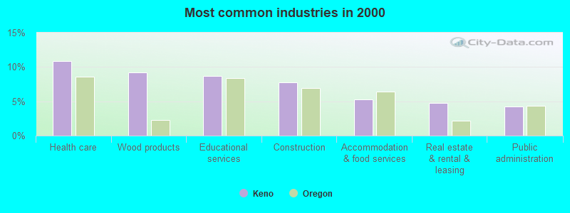
- Health care (10.8%)
- Wood products (9.2%)
- Educational services (8.6%)
- Construction (7.8%)
- Accommodation & food services (5.3%)
- Real estate & rental & leasing (4.8%)
- Public administration (4.2%)
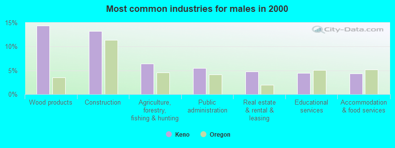
- Wood products (14.4%)
- Construction (13.2%)
- Agriculture, forestry, fishing & hunting (6.4%)
- Public administration (5.5%)
- Real estate & rental & leasing (4.8%)
- Educational services (4.5%)
- Accommodation & food services (4.4%)
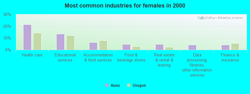
- Health care (21.4%)
- Educational services (13.6%)
- Accommodation & food services (6.4%)
- Food & beverage stores (4.8%)
- Real estate & rental & leasing (4.8%)
- Data processing, libraries, other information services (4.2%)
- Finance & insurance (4.2%)

- Other sales and related occupations, including supervisors (6.7%)
- Building and grounds cleaning and maintenance occupations (6.5%)
- Retail sales workers, except cashiers (4.7%)
- Other production occupations, including supervisors (4.4%)
- Other management occupations, except farmers and farm managers (4.4%)
- Construction traders workers except carpenters, electricians, painters, plumbers, and construction laborers (3.4%)
- Registered nurses (3.1%)

- Building and grounds cleaning and maintenance occupations (8.9%)
- Other management occupations, except farmers and farm managers (7.3%)
- Other sales and related occupations, including supervisors (6.6%)
- Construction traders workers except carpenters, electricians, painters, plumbers, and construction laborers (6.3%)
- Driver/sales workers and truck drivers (5.5%)
- Other production occupations, including supervisors (4.0%)
- Retail sales workers, except cashiers (3.6%)

- Other sales and related occupations, including supervisors (7.0%)
- Retail sales workers, except cashiers (6.0%)
- Registered nurses (5.6%)
- Information and record clerks, except customer service representatives (5.4%)
- Secretaries and administrative assistants (5.4%)
- Other production occupations, including supervisors (5.0%)
- Other office and administrative support workers, including supervisors (4.2%)
Average climate in Keno, Oregon
Based on data reported by over 4,000 weather stations


(lower is better)

Air Quality Index (AQI) level in 2022 was 83.2. This is about average.
| City: | 83.2 |
| U.S.: | 72.6 |

Particulate Matter (PM10) [µg/m3] level in 2020 was 36.9. This is significantly worse than average. Closest monitor was 13.2 miles away from the city center.
| City: | 36.9 |
| U.S.: | 19.2 |

Particulate Matter (PM2.5) [µg/m3] level in 2022 was 8.21. This is about average. Closest monitor was 21.6 miles away from the city center.
| City: | 8.21 |
| U.S.: | 8.11 |
Earthquake activity:
Keno-area historical earthquake activity is significantly above Oregon state average. It is 3504% greater than the overall U.S. average.On 1/31/1922 at 13:17:28, a magnitude 7.6 (7.6 UK, Class: Major, Intensity: VIII - XII) earthquake occurred 210.7 miles away from the city center
On 4/18/1906 at 13:12:21, a magnitude 7.9 (7.9 UK) earthquake occurred 302.9 miles away from the city center, causing $524,000,000 total damage
On 11/8/1980 at 10:27:34, a magnitude 7.2 (6.2 MB, 7.2 MS, 7.2 MW, 7.0 ML) earthquake occurred 140.9 miles away from the city center
On 4/25/1992 at 18:06:04, a magnitude 7.2 (6.3 MB, 7.1 MS, 7.2 MW, 7.1 MW, Depth: 9.4 mi) earthquake occurred 170.3 miles away from the city center, causing $75,000,000 total damage
On 10/3/1915 at 06:52:48, a magnitude 7.6 (7.6 UK) earthquake occurred 270.4 miles away from the city center
On 8/17/1991 at 22:17:14, a magnitude 7.1 (6.2 MB, 7.1 MS, 7.1 MW, 6.8 ML, Depth: 8.4 mi) earthquake occurred 182.9 miles away from the city center
Magnitude types: body-wave magnitude (MB), local magnitude (ML), surface-wave magnitude (MS), moment magnitude (MW)
Natural disasters:
The number of natural disasters in Klamath County (8) is smaller than the US average (15).Major Disasters (Presidential) Declared: 4
Emergencies Declared: 2
Causes of natural disasters: Fires: 2, Floods: 2, Drought: 1, Earthquake: 1, Heavy Rain: 1, Hurricane: 1, Wind: 1, Winter Storm: 1, Other: 1 (Note: some incidents may be assigned to more than one category).
Colleges/universities with over 2000 students nearest to Keno:
- Oregon Institute of Technology (about 18 miles; Klamath Falls, OR; Full-time enrollment: 2,900)
- Southern Oregon University (about 32 miles; Ashland, OR; FT enrollment: 4,650)
- Rogue Community College (about 66 miles; Grants Pass, OR; FT enrollment: 3,600)
- Shasta College (about 119 miles; Redding, CA; FT enrollment: 5,645)
- Lane Community College (about 126 miles; Eugene, OR; FT enrollment: 6,373)
- Central Oregon Community College (about 127 miles; Bend, OR; FT enrollment: 5,217)
- University of Oregon (about 129 miles; Eugene, OR; FT enrollment: 23,329)
Public elementary/middle school in Keno:
- KENO ELEMENTARY SCHOOL (Students: 182, Location: 11110 KENO-WORDEN RD, Grades: KG-6)
Points of interest:
Notable locations in Keno: King Spruce Camp (A), King Cole (B), Rainbow Bay Boat Launch (C), Aspen Point Campground Boat Ramp (D), Sevenmile Marsh Campground (E), Sunset Camp (F), Cold Springs Campground (G), Harriman Lodge (H), Sevenmile Marsh Trailhead (I), Great Meadows Recreation Site (J), Lake of the Woods Resort (K), Pelican Fire Guard Station (L), Cold Springs Recreation Site (M), Crystal Springs Recreation Site (N), Crystal Spring Trailhead (O), Malone Springs Recreation Site (P), Sunset Recreation Site (Q), Annie Creek Sno-Park (R), South Entrance Crater Lake National Park (S), Surveyor Mountain Recreation Site (T). Display/hide their locations on the map
Cemeteries: Way Cemetery (1), Spencer Cemetery (2), Worden Cemetery (3), Keno Cemetery (4). Display/hide their locations on the map
Lakes, reservoirs, and swamps: Lake Francis (A), Freye Lake (B), Frog Lake (C), White Pine Lake (D), Lake Gladys (E), Grass Lake (F), Mystic Lake (G), Lake Harriette (H). Display/hide their locations on the map
Streams, rivers, and creeks: Fourmile Slough (A), Horse Creek (B), South Creek (C), Bridge Creek (D), Camp Creek (E), Honeymoon Creek (F), Annie Creek Slough (G), Nannie Creek (H), Hayden Creek (I). Display/hide their locations on the map
Parks in Keno include: Eagle Ridge County Park (1), Upper Klamath National Wildlife Refuge (2), Klamath River Recreation Site (3), Bear Valley National Wildlife Refuge (4), Crystal Creek County Park (5), Topsy Recreation Site (6), Denny Creek Historic Monument (7), Howard Bay Park (8). Display/hide their locations on the map
| This place: | 2.3 people |
| Oregon: | 2.5 people |
| This place: | 71.3% |
| Whole state: | 63.4% |
| This place: | 5.9% |
| Whole state: | 8.0% |
Likely homosexual households (counted as self-reported same-sex unmarried-partner households)
- Lesbian couples: 0.5% of all households
- Gay men: 0.4% of all households
| This place: | 12.4% |
| Whole state: | 11.6% |
| This place: | 2.4% |
| Whole state: | 5.0% |
For population 15 years and over in Keno:

- Never married: 15.1%
- Now married: 71.8%
- Separated: 0.3%
- Widowed: 3.1%
- Divorced: 10.0%
For population 25 years and over in Keno:
- High school or higher: 85.8%
- Bachelor's degree or higher: 14.3%
- Graduate or professional degree: 5.6%
- Unemployed: 6.3%
- Mean travel time to work (commute): 20.7 minutes


| Here: | 9.1 |
| Oregon average: | 11.5 |
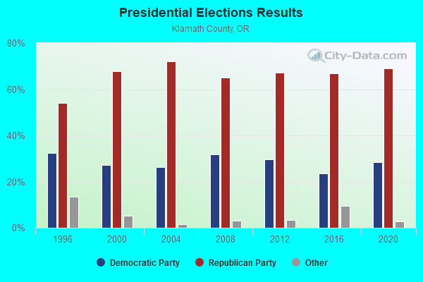
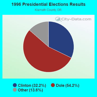
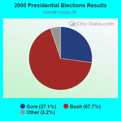
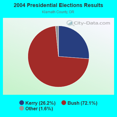
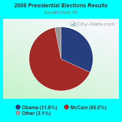
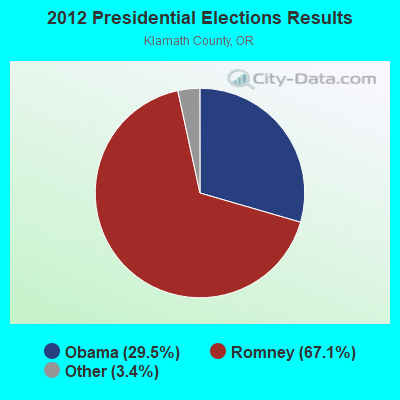
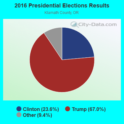
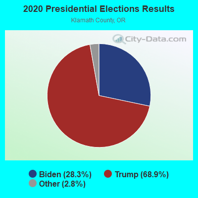
Graphs represent county-level data. Detailed 2008 Election Results
Religion statistics for Keno, OR (based on Klamath County data)
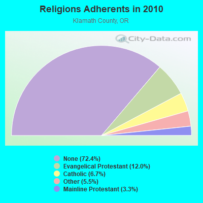
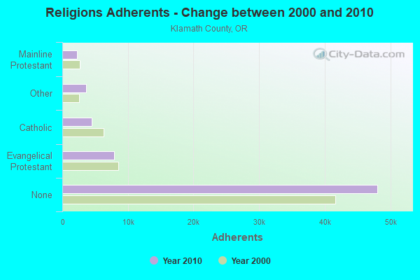
| Religion | Adherents | Congregations |
|---|---|---|
| Evangelical Protestant | 7,945 | 63 |
| Catholic | 4,460 | 7 |
| Other | 3,677 | 14 |
| Mainline Protestant | 2,218 | 14 |
| Black Protestant | 30 | 1 |
| None | 48,050 | - |
Food Environment Statistics:
| Klamath County: | 2.41 / 10,000 pop. |
| Oregon: | 2.03 / 10,000 pop. |
| Here: | 0.30 / 10,000 pop. |
| State: | 0.33 / 10,000 pop. |
| Here: | 1.81 / 10,000 pop. |
| Oregon: | 2.01 / 10,000 pop. |
| This county: | 2.71 / 10,000 pop. |
| Oregon: | 1.69 / 10,000 pop. |
| This county: | 8.88 / 10,000 pop. |
| Oregon: | 9.93 / 10,000 pop. |
| This county: | 8.3% |
| Oregon: | 7.4% |
| This county: | 25.0% |
| State: | 25.6% |
| Klamath County: | 12.0% |
| Oregon: | 14.2% |
7.87% of this county's 2021 resident taxpayers lived in other counties in 2020 ($50,573 average adjusted gross income)
| Here: | 7.87% |
| Oregon average: | 8.20% |
0.09% of residents moved from foreign countries ($401 average AGI)
Klamath County: 0.09% Oregon average: 0.01%
Top counties from which taxpayers relocated into this county between 2020 and 2021:
| from Deschutes County, OR | |
| from Jackson County, OR | |
| from Lane County, OR |
Strongest AM radio stations in Keno:
- KTMT (580 AM; 10 kW; ASHLAND, OR; Owner: MAPLETON COMMUNICATIONS, LLC)
- KAGO (1150 AM; 5 kW; KLAMATH FALLS, OR; Owner: NEW NORTHWEST BROADCASTERS, LLC)
- KAPL (1300 AM; 20 kW; PHOENIX, OR; Owner: APPLEGATE MEDIA, INC.)
- KKJX (960 AM; 5 kW; KLAMATH FALLS, OR; Owner: NEW NORTHWEST BROADCASTERS, LLC)
- KRTA (610 AM; 5 kW; MEDFORD, OR; Owner: OPUS BROADCASTING SYSTEMS, INC.)
- KGRV (700 AM; 25 kW; WINSTON, OR; Owner: PACIFIC CASCADE COMMUNICATIONS CORP.)
- KPNW (1120 AM; 50 kW; EUGENE, OR; Owner: CAPSTAR TX LIMITED PARTNERSHIP)
- KMED (1440 AM; 5 kW; MEDFORD, OR; Owner: CITICASTERS LICENSES, L.P.)
- KDUN (1030 AM; 50 kW; REEDSPORT, OR; Owner: PAMPLIN BROADCASTING-OREGON, INC.)
- KAJO (1270 AM; 10 kW; GRANTS PASS, OR; Owner: GRANTS PASS BROADCASTING CORPORATION)
- KFLS (1450 AM; 1 kW; KLAMATH FALLS, OR; Owner: WYNNE BROADCASTING COMPANY)
- KPOJ (620 AM; 50 kW; PORTLAND, OR; Owner: CITICASTERS LICENSES, L.P.)
- KXL (750 AM; 50 kW; PORTLAND, OR; Owner: ROSE CITY RADIO CORPORATION)
Strongest FM radio stations in Keno:
- KKRB (106.9 FM; KLAMATH FALLS, OR; Owner: WYNNE BROADCASTING COMPANY, INC.)
- KFEG (104.7 FM; KLAMATH FALLS, OR; Owner: COVE ROAD PUBLISHING LLC)
- KKLJ (88.9 FM; KLAMATH FALLS, OR; Owner: EDUCATIONAL MEDIA FOUNDATION)
- KLAD-FM (92.5 FM; KLAMATH FALLS, OR; Owner: NEW NORTHWEST BROADCASTERS, LLC)
- KRAT (97.7 FM; ALTAMONT, OR; Owner: GEORGE J. WADE)
- KAKT (105.1 FM; PHOENIX, OR; Owner: MAPLETON COMMUNICATIONS, LLC)
- KTMT-FM (93.7 FM; MEDFORD, OR; Owner: MAPLETON COMMUNICATIONS, LLC)
- KSKF (90.9 FM; KLAMATH FALLS, OR; Owner: ST OF OREGON ACT BY ST BOARD OF HIGH ED)
- K210BY (89.9 FM; KLAMATH FALLS, OR; Owner: PENSACOLA CHRISTIAN COLLEGE, INC.)
- KLMF (88.5 FM; KLAMATH FALLS, OR; Owner: THE STATE BOARD OF HIGHER EDUCATION)
- KFLS-FM (96.5 FM; TULELAKE, CA; Owner: WYNNE BROADCASTING COMPANY, INC.)
- KAGO-FM (99.5 FM; KLAMATH FALLS, OR; Owner: NEW NORTHWEST BROADCASTERS, LLC)
- KLDZ (103.5 FM; MEDFORD, OR; Owner: CITICASTERS LICENSES, L.P.)
- KYSF (102.9 FM; BONANZA, OR; Owner: NEW NORTHWEST BROADCASTERS, LLC)
- K254AD (98.7 FM; MEDFORD, OR; Owner: GRANTS PASS BROADCASTING CORPORATION)
- KZZE (106.3 FM; EAGLE POINT, OR; Owner: CITICASTERS LICENSES, L.P.)
- KIFS (107.5 FM; ASHLAND, OR; Owner: CITICASTERS LICENSES, L.P.)
- KTEC (89.5 FM; KLAMATH FALLS, OR; Owner: STATE BOARD OF HIGHER EDUCATION)
- K235AG (94.9 FM; DORRIS, CA; Owner: CALVARY CHAPEL OF TWIN FALLS, INC.)
- K216DR (91.1 FM; CENTRAL POINT, OR; Owner: EDUCATIONAL MEDIA FOUNDATION)
FCC Registered Cell Phone Towers:
2 (See the full list of FCC Registered Cell Phone Towers in Keno)FCC Registered Antenna Towers:
18 (See the full list of FCC Registered Antenna Towers)FCC Registered Broadcast Land Mobile Towers:
5- Haymaker Mtn 2.5 Mi Sw (Lat: 42.083472 Lon: -121.959167), Call Sign: KML448, Licensee ID: L00002096,
Assigned Frequencies: 154.100 MHz, 154.100 MHz, Grant Date: 09/15/1999, Expiration Date: 11/30/2004, Cancellation Date: 12/18/2002, Registrant: County Of Siskiyou, 305 Butte St, Yreka, CA 96097, Phone: (916) 842-8250
- Hamaker Mountain 2 1/2 Mi Sw (Lat: 42.083472 Lon: -121.859167), Call Sign: KAP724,
Assigned Frequencies: 155.310 MHz, 155.310 MHz, Grant Date: 09/30/2004, Expiration Date: 11/30/2014, Cancellation Date: 05/05/2011, Registrant: County Of Siskiyou, 305 Butte St, Yreka, CA 96097, Phone: (530) 842-8281, Fax: (530) 842-8288
- Haymaker Mountain 4.2 Mi Sw (Lat: 42.070972 Lon: -121.973889), Type: Tower, Structure height: 15 m, Overall height: 21 m, Call Sign: KTC271, Licensee ID: L00008317,
Assigned Frequencies: 451.300 MHz, Grant Date: 10/22/1996, Expiration Date: 10/22/2001, Cancellation Date: 01/23/2001, Certifier: William A Honey, Registrant: Qwest Corporation, 700 W Mineral Ave Rm Co G1.24, Littleton, CO 80120, Phone: (303) 707-8706, Fax: (303) 707-9775
- HAMKR MNTN RADIOSITE, 16980 Hamaker Mountain Road (Lat: 42.068278 Lon: -121.968222), Type: Ltower, Structure height: 49.1 m, Overall height: 53.7 m, Call Sign: WQGQ845,
Assigned Frequencies: 44.5800 MHz, 160.665 MHz, 161.100 MHz, 160.530 MHz, Grant Date: 12/28/2016, Expiration Date: 03/27/2027, Certifier: Robert Leedham, Registrant: Bnsf Railway Co., 4515 Kansas Ave, Kansas City, KS 66106, Phone: (913) 551-4015, Fax: (913) 551-4053, Email:
- 6.3 Km Of Keno (Lat: 42.094611 Lon: -121.994056), Type: Mast, Structure height: 15.2 m, Call Sign: WRAK946,
Assigned Frequencies: 4955.00 MHz, 4975.00 MHz, 4955.00 MHz, 4975.00 MHz, Grant Date: 12/19/2017, Expiration Date: 12/19/2027, Certifier: Ryan M Gantt, Registrant: Oregon Dept. Of Forestry, 2600 State St, Salem, OR 97310, Phone: (503) 945-7321, Fax: (503) 945-7320, Email:
FCC Registered Microwave Towers:
9 (See the full list of FCC Registered Microwave Towers in this town)FCC Registered Paging Towers:
1 (See the full list of FCC Registered Paging Towers)FCC Registered Amateur Radio Licenses:
50 (See the full list of FCC Registered Amateur Radio Licenses in Keno)FAA Registered Aircraft:
2- Aircraft: PIPER PA-28-151 (Category: Land, Seats: 4, Weight: Up to 12,499 Pounds, Speed: 80 mph), Engine: LYCOMING 0-320 SERIES (180 HP) (Reciprocating)
N-Number: 44318, N44318, N-44318, Serial Number: 28-7415621, Year manufactured: 1974, Airworthiness Date: 07/16/1974, Certificate Issue Date: 02/19/2008
Registrant (Co-Owned): John R Jr Longley, Po Box 47, Keno, OR 97627, Other Owners: Theresa E Longley - Aircraft: SHERMAN MARK SHERMAN CH-701 (Category: Land, Seats: 2, Weight: Up to 12,499 Pounds), Engine: ROTAX 912ULS SERIES (100 HP) (Reciprocating)
N-Number: 752MS, N752MS, N-752MS, Serial Number: 7-4368, Year manufactured: 2009, Airworthiness Date: 03/17/2009, Certificate Issue Date: 12/17/2018
Registrant (Individual): Michael L Cheeseman, Po Box 1078, Keno, OR 97627
2003 - 2018 National Fire Incident Reporting System (NFIRS) incidents
- Fire incident types reported to NFIRS in Keno, OR
- 11070.5%Outside Fires
- 2918.6%Structure Fires
- 138.3%Mobile Property/Vehicle Fires
- 42.6%Other
 According to the data from the years 2003 - 2018 the average number of fire incidents per year is 10. The highest number of reported fires - 23 took place in 2016, and the least - 0 in 2009. The data has an increasing trend.
 When looking into fire subcategories, the most incidents belonged to: Outside Fires (70.5%), and Structure Fires (18.6%).
- 34.1%Electricity
- 25.4%Utility gas
- 19.1%Wood
- 18.1%Fuel oil, kerosene, etc.
- 2.8%Bottled, tank, or LP gas
- 0.5%Other fuel

- 34.6%Electricity
- 31.8%Wood
- 22.3%Utility gas
- 6.7%Fuel oil, kerosene, etc.
- 4.5%Bottled, tank, or LP gas
Keno compared to Oregon state average:
- Median house value below state average.
- Unemployed percentage below state average.
- Black race population percentage significantly below state average.
- Hispanic race population percentage significantly below state average.
- Median age above state average.
- Foreign-born population percentage significantly below state average.
- Renting percentage significantly below state average.
- Length of stay since moving in significantly above state average.
- Number of rooms per house significantly below state average.
- House age significantly below state average.
- Percentage of population with a bachelor's degree or higher below state average.
Keno on our top lists:
- #77 on the list of "Top 101 cities with the most residents born in Other Central America (population 500+)"
- #11 on the list of "Top 101 counties with the lowest surface withdrawal of fresh water for public supply"
- #72 on the list of "Top 101 counties with highest percentage of residents voting for 3rd party candidates in the 2012 Presidential Election (pop. 50,000+)"

|
Total of 7 patent applications in 2008-2024.