Silver Lake-Fort Rock, Oregon
Silver Lake-Fort Rock: In the "Town" of Ft Rock....
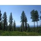
Silver Lake-Fort Rock: Forest on Newberry Crater...
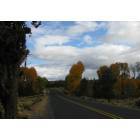
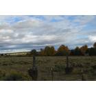
Silver Lake-Fort Rock: Autumn on Hwy 31....
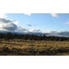
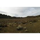
Silver Lake-Fort Rock: Junipers Near Silver Lake
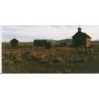
Silver Lake-Fort Rock: Town of Fort Rock....
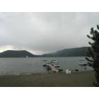
Silver Lake-Fort Rock: Silver Lake Fall....
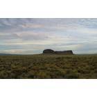
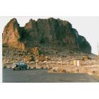
Silver Lake-Fort Rock: Fort Rock....

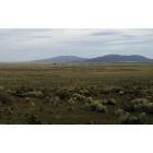
Silver Lake-Fort Rock: Big Sky Country....
Silver Lake-Fort Rock: Inside Fort Rock.....
Silver Lake-Fort Rock: Storm over East Lake...
Silver Lake-Fort Rock: Ft Rock Trailhead....
- add
your
Submit your own pictures of this place and show them to the world
- OSM Map
- Google Map
- MSN Map
| Males: 800 | |
| Females: 740 |
| Median resident age: | 41.2 years |
| Oregon median age: | 36.3 years |
Zip code: 97638
| Silver Lake-Fort Rock: | $44,542 |
| OR: | $75,657 |
Estimated per capita income in 2022: $26,481 (it was $14,305 in 2000)
Silver Lake-Fort Rock CCD income, earnings, and wages data
Estimated median house or condo value in 2022: $175,535 (it was $60,800 in 2000)
| Silver Lake-Fort Rock: | $175,535 |
| OR: | $475,600 |
Silver Lake-Fort Rock, OR residents, houses, and apartments details
Detailed information about poverty and poor residents in Silver Lake-Fort Rock, OR
Compare current foreclosures near your location:
| Photo | Address | Area | Beds / Baths | Price | Details |
|---|---|---|---|---|---|

|
#1
Bayberry Cir
Columbus, OH 43207
|
1,564 sq. feet
|
1 baths 3 beds |
$127,500
|
show details |

|
#2
E 21st Ave
Columbus, OH 43211
|
1,061 sq. feet
|
1 baths 3 beds |
$179,900
|
show details |

|
#3
S High St
Columbus, OH 43207
|
1,678 sq. feet
|
2 baths 4 beds |
$27,500
|
show details |

|
#4
Inishmore Ln
Dublin, OH 43017
|
912 sq. feet
|
1 baths 1 beds |
show details | |

|
#5
Lewis Rd
Columbus, OH 43207
|
1,976 sq. feet
|
2 baths 4 beds |
show details | |

|
#6
Front St
Commercial Point, OH 43116
|
1,311 sq. feet
|
2 baths 3 beds |
show details | |

|
#7
Wallcrest Blvd
Columbus, OH 43231
|
2,152 sq. feet
|
3 baths 3 beds |
show details | |

|
#8
Hall Rd
Galloway, OH 43119
|
1,008 sq. feet
|
1 baths 3 beds |
show details | |

|
#9
Braeburn Ct
Blacklick, OH 43004
|
2,122 sq. feet
|
3 baths 4 beds |
show details | |

|
#10
Elm Ct
Westerville, OH 43082
|
2,022 sq. feet
|
3 baths 4 beds |
show details |
| Photo | Address | Area | Beds / Baths | Price | Details |
|---|---|---|---|---|---|

|
#11
Wallcrest Blvd
Columbus, OH 43231
|
2,236 sq. feet
|
3 baths 4 beds |
show details | |

|
#12
Ironstone Dr
Columbus, OH 43231
|
1,236 sq. feet
|
2 baths 3 beds |
show details | |

|
#13
Hardwood Dr
Galloway, OH 43119
|
2,435 sq. feet
|
3 baths 3 beds |
show details | |

|
#14
Heritage Lakes Dr
Hilliard, OH 43026
|
3,895 sq. feet
|
5 baths 4 beds |
show details | |

|
#15
Andrew Rd
Columbus, OH 43227
|
1,053 sq. feet
|
2 baths 3 beds |
show details | |

|
#16
Golden Cloud Ln
Columbus, OH 43228
|
1,576 sq. feet
|
3 baths 3 beds |
show details | |

|
#17
Alderson Ct
Columbus, OH 43228
|
1,224 sq. feet
|
3 baths 3 beds |
show details | |

|
#18
Doral Ave
Columbus, OH 43213
|
2,124 sq. feet
|
3 baths 4 beds |
show details | |

|
#19
Edgeview Rd
Columbus, OH 43207
|
1,700 sq. feet
|
1 baths 4 beds |
show details | |

|
#20
Firwood Dr
Columbus, OH 43229
|
1,483 sq. feet
|
2 baths 3 beds |
show details |
| Photo | Address | Area | Beds / Baths | Price | Details |
|---|---|---|---|---|---|

|
#21
Baker Hill Rd
Columbus, OH 43207
|
896 sq. feet
|
1 baths 3 beds |
show details | |

|
#22
Minerva Park Pl
Columbus, OH 43229
|
965 sq. feet
|
3 baths 3 beds |
show details | |

|
#23
Big Walnut Dr
Groveport, OH 43125
|
1,028 sq. feet
|
1 baths 3 beds |
show details | |

|
#24
Sweeny Ct
Dublin, OH 43017
|
2,160 sq. feet
|
3 baths 4 beds |
show details | |

|
#25
Lovell Ln
Blacklick, OH 43004
|
1,920 sq. feet
|
3 baths 3 beds |
show details | |

|
#26
Sandalwood Blvd
Columbus, OH 43229
|
1,161 sq. feet
|
2 baths 3 beds |
show details | |

|
#27
Hempwood Dr
Columbus, OH 43229
|
1,360 sq. feet
|
2 baths 3 beds |
show details | |

|
#28
Westrock Dr
Hilliard, OH 43026
|
1,819 sq. feet
|
3 baths 3 beds |
show details | |

|
#29
Steiner St
Columbus, OH 43231
|
1,464 sq. feet
|
3 baths 3 beds |
show details | |

|
#30
Dunkirk Dr
Columbus, OH 43219
|
924 sq. feet
|
1 baths 3 beds |
show details |
| Photo | Address | Area | Beds / Baths | Price | Details |
|---|---|---|---|---|---|

|
#31
Richardson Rd
Groveport, OH 43125
|
1,080 sq. feet
|
3 baths 4 beds |
show details | |

|
#32
Parkwood Ave
Columbus, OH 43211
|
672 sq. feet
|
1 baths 2 beds |
show details | |

|
#33
Brookview Cir
Pickerington, OH 43147
|
1,280 sq. feet
|
3 baths 2 beds |
show details | |

|
#34
Chinquo St
Grove City, OH 43123
|
1,158 sq. feet
|
2 baths 3 beds |
show details | |

|
#35
N Dawson Ave
Columbus, OH 43219
|
888 sq. feet
|
2 baths 3 beds |
show details | |

|
#36
Scriven Ave
Columbus, OH 43228
|
832 sq. feet
|
2 baths 2 beds |
show details | |

|
#37
Silo Ct
Hilliard, OH 43026
|
2,865 sq. feet
|
4 baths 4 beds |
show details | |

|
#38
Muldoon Ct
Dublin, OH 43016
|
1,816 sq. feet
|
3 baths 3 beds |
show details | |

|
#39
Brookfield Rd
Columbus, OH 43229
|
924 sq. feet
|
1 baths 3 beds |
show details | |

|
#40
Wynnewood Dr
Grove City, OH 43123
|
3,170 sq. feet
|
3 baths 4 beds |
show details |
| Photo | Address | Area | Beds / Baths | Price | Details |
|---|---|---|---|---|---|

|
#41
Dover Rd
Columbus, OH 43209
|
2,019 sq. feet
|
3 baths 3 beds |
show details | |

|
#42
Oakland Park Ave
Columbus, OH 43224
|
1,127 sq. feet
|
1 baths 3 beds |
show details | |

|
#43
Hepplewhite St
Westerville, OH 43081
|
1,570 sq. feet
|
3 baths 4 beds |
show details | |

|
#44
Black Kettle Trl
Dublin, OH 43017
|
1,768 sq. feet
|
3 baths 4 beds |
show details | |

|
#45
Maplerun Ln
Westerville, OH 43081
|
2,020 sq. feet
|
3 baths 4 beds |
show details | |

|
#46
Norman Dr
Columbus, OH 43227
|
1,260 sq. feet
|
2 baths 3 beds |
show details | |

|
#47
Prosperity Ln
Columbus, OH 43231
|
1,376 sq. feet
|
3 baths 3 beds |
show details | |

|
#48
Alkire Rd
Grove City, OH 43123
|
1,680 sq. feet
|
3 baths 4 beds |
show details | |

|
#49
Bar Harbor Rd
Columbus, OH 43219
|
960 sq. feet
|
2 baths 3 beds |
show details | |

|
Check over 1 million property listings on Foreclosure.com!
|
browse all offers | |||

- 1,41789.5%White alone
- 553.5%Two or more races
- 523.3%Hispanic
- 513.2%American Indian alone
- 40.3%Black alone
- 20.1%Asian alone
- 20.1%Native Hawaiian and Other
Pacific Islander alone

Races in Silver Lake-Fort Rock detailed stats: ancestries, foreign born residents, place of birth
 Recent articles from our blog. Our writers, many of them Ph.D. graduates or candidates, create easy-to-read articles on a wide variety of topics.
Current Local Time: PST time zone
Land area: 2988.8 square miles.
Population density: 0.5 people per square mile (very low).
| Silver Lake-Fort Rock CCD: | 1.0% ($631) |
| Oregon: | 1.2% ($1,687) |
Nearest city with pop. 50,000+: Bend, OR  (54.3 miles , pop. 52,029).
Nearest city with pop. 200,000+: Northwest Clackamas, OR (166.9 miles , pop. 224,220).
Nearest city with pop. 1,000,000+: Los Angeles, CA (654.5 miles , pop. 3,694,820).
Nearest cities:
)Latitude: 43.36 N, Longitude: 120.82 W
Area code commonly used in this area: 541

| Here: | 5.6% |
| Oregon: | 3.9% |

- Agriculture, forestry, fishing & hunting (38.2%)
- Educational services (11.3%)
- Construction (7.0%)
- Accommodation & food services (5.9%)
- Food & beverage stores (3.8%)
- Public administration (3.7%)
- Social assistance (3.0%)

- Agriculture, forestry, fishing & hunting (52.1%)
- Construction (10.9%)
- Accommodation & food services (4.7%)
- Educational services (4.4%)
- Truck transportation (3.3%)
- Repair & maintenance (3.0%)
- Administrative & support & waste management services (2.4%)

- Educational services (21.3%)
- Agriculture, forestry, fishing & hunting (18.3%)
- Food & beverage stores (7.7%)
- Accommodation & food services (7.7%)
- Social assistance (7.2%)
- Public administration (6.8%)
- Health care (6.8%)

- Farmers and farm managers (18.2%)
- Agricultural workers, including supervisors (11.2%)
- Building and grounds cleaning and maintenance occupations (5.4%)
- Driver/sales workers and truck drivers (4.7%)
- Other management occupations, except farmers and farm managers (4.2%)
- Preschool, kindergarten, elementary, and middle school teachers (3.7%)
- Secretaries and administrative assistants (2.8%)

- Farmers and farm managers (24.3%)
- Agricultural workers, including supervisors (16.0%)
- Driver/sales workers and truck drivers (8.0%)
- Building and grounds cleaning and maintenance occupations (5.3%)
- Vehicle and mobile equipment mechanics, installers, and repairers (4.4%)
- Electrical equipment mechanics and other installation, maintenance, and repair workers, including supervisors (3.8%)
- Construction traders workers except carpenters, electricians, painters, plumbers, and construction laborers (3.3%)

- Farmers and farm managers (9.4%)
- Preschool, kindergarten, elementary, and middle school teachers (7.2%)
- Secretaries and administrative assistants (6.8%)
- Other management occupations, except farmers and farm managers (6.4%)
- Building and grounds cleaning and maintenance occupations (5.5%)
- Child care workers (5.1%)
- Cashiers (5.1%)
Average climate in Silver Lake-Fort Rock, Oregon
Based on data reported by over 4,000 weather stations


Earthquake activity:
Silver Lake-Fort Rock-area historical earthquake activity is significantly above Oregon state average. It is 2878% greater than the overall U.S. average.On 10/3/1915 at 06:52:48, a magnitude 7.6 (7.6 UK, Class: Major, Intensity: VIII - XII) earthquake occurred 261.1 miles away from Silver Lake-Fort Rock center
On 1/31/1922 at 13:17:28, a magnitude 7.6 (7.6 UK) earthquake occurred 304.8 miles away from the city center
On 11/8/1980 at 10:27:34, a magnitude 7.2 (6.2 MB, 7.2 MS, 7.2 MW, 7.0 ML) earthquake occurred 236.5 miles away from the city center
On 4/18/1906 at 13:12:21, a magnitude 7.9 (7.9 UK) earthquake occurred 387.8 miles away from the city center, causing $524,000,000 total damage
On 4/25/1992 at 18:06:04, a magnitude 7.2 (6.3 MB, 7.1 MS, 7.2 MW, 7.1 MW, Depth: 9.4 mi) earthquake occurred 267.0 miles away from Silver Lake-Fort Rock center, causing $75,000,000 total damage
On 8/17/1991 at 22:17:14, a magnitude 7.1 (6.2 MB, 7.1 MS, 7.1 MW, 6.8 ML, Depth: 8.4 mi) earthquake occurred 267.2 miles away from Silver Lake-Fort Rock center
Magnitude types: body-wave magnitude (MB), local magnitude (ML), surface-wave magnitude (MS), moment magnitude (MW)
Natural disasters:
The number of natural disasters in Lake County (8) is smaller than the US average (15).Major Disasters (Presidential) Declared: 4
Emergencies Declared: 2
Causes of natural disasters: Fires: 2, Floods: 2, Winter Storms: 2, Drought: 1, Heavy Rain: 1, Hurricane: 1, Wind: 1, Other: 1 (Note: some incidents may be assigned to more than one category).
Colleges/universities with over 2000 students nearest to Silver Lake-Fort Rock:
- Central Oregon Community College (about 57 miles; Bend, OR; Full-time enrollment: 5,217)
- Oregon Institute of Technology (about 91 miles; Klamath Falls, OR; FT enrollment: 2,900)
- Lane Community College (about 120 miles; Eugene, OR; FT enrollment: 6,373)
- University of Oregon (about 123 miles; Eugene, OR; FT enrollment: 23,329)
- Southern Oregon University (about 126 miles; Ashland, OR; FT enrollment: 4,650)
- Linn-Benton Community College (about 143 miles; Albany, OR; FT enrollment: 4,511)
- Rogue Community College (about 147 miles; Grants Pass, OR; FT enrollment: 3,600)
Points of interest:
Notable locations in Silver Lake-Fort Rock: Jones Well Guard Station (A), Linebaugh Ranch (B), Howard Ranch (C), Lane Ranch (D), Johnson Ranch (E), T Emery Ranch (F), Remery Ranch (G), D Emery Ranch (H), Wickiup Spring Forest Service Station (I), Cabin Lake Recreation Site (J), Gowdy Ranch (K), Dehne Ranch (L), Horse Ranch (M), Geo Peyerl Ranch (N), Freeman Ranch (O), Conley (P), Three-Mile Corner (Q), Anderl Place (R), Elk Butte Camp (S), Wing Butte Cabin (T). Display/hide their locations on the map
Cemeteries: Fort Rock Cemetery (1), Silver Lake Cemetery (2). Display/hide their locations on the map
Lakes, reservoirs, and swamps: Halfway Lake (A), Rocky Waterhole (B), Ward Lake (C), Lily Lake (D), North Alkali Lake (E), Depaoli Lake (F), Fire Lake (G), Diatomite Reservoir (H). Display/hide their locations on the map
Streams, rivers, and creeks: Murdock Creek (A), Willow Creek (B), Duncan Creek (C), Walker Creek (D), Buck Creek (E), Bridge Creek (F), Bear Creek (G), Bunyard Creek (H), Conley Creek (I). Display/hide their locations on the map
Parks in Silver Lake-Fort Rock include: Cabin Lake Wildlife Area (1), Fort Rock State Park (2). Display/hide their locations on the map
| This place: | 2.2 people |
| Oregon: | 2.5 people |
| This place: | 61.4% |
| Whole state: | 63.4% |
| This place: | 6.2% |
| Whole state: | 8.0% |
Likely homosexual households (counted as self-reported same-sex unmarried-partner households)
- Lesbian couples: 0.1% of all households
- Gay men: 0.1% of all households
| This place: | 23.6% |
| Whole state: | 11.6% |
| This place: | 6.7% |
| Whole state: | 5.0% |
2 people in agriculture workers' dormitories on farms in 2000
For population 15 years and over in Silver Lake-Fort Rock:

- Never married: 15.3%
- Now married: 66.9%
- Separated: 2.0%
- Widowed: 4.3%
- Divorced: 13.5%
For population 25 years and over in Silver Lake-Fort Rock:
- High school or higher: 77.9%
- Bachelor's degree or higher: 12.1%
- Graduate or professional degree: 2.6%
- Unemployed: 10.2%
- Mean travel time to work (commute): 16.4 minutes


| Here: | 9.3 |
| Oregon average: | 11.5 |
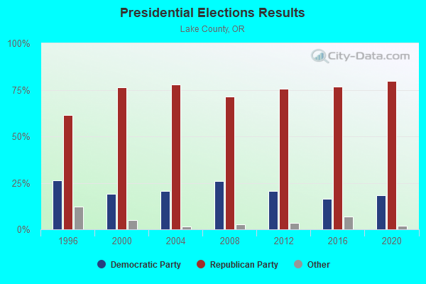
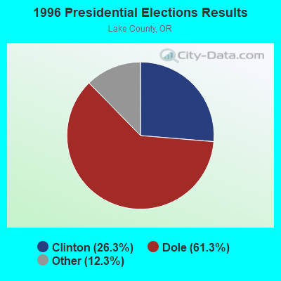
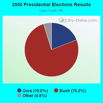
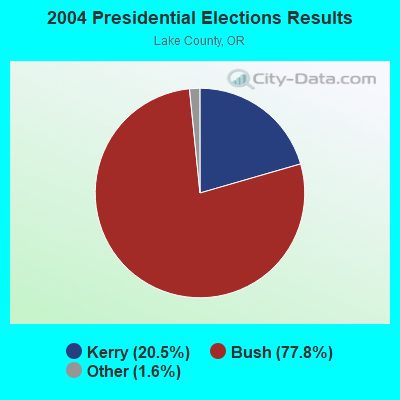
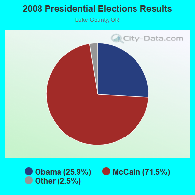
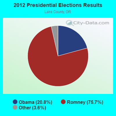
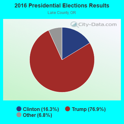
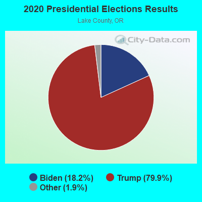
Graphs represent county-level data. Detailed 2008 Election Results
Religion statistics for Silver Lake-Fort Rock, OR (based on Lake County data)
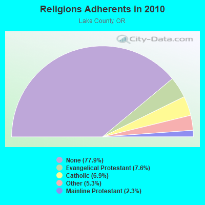
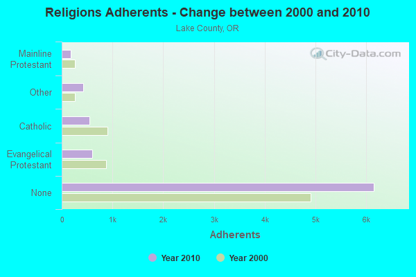
| Religion | Adherents | Congregations |
|---|---|---|
| Evangelical Protestant | 597 | 14 |
| Catholic | 548 | 5 |
| Other | 417 | 3 |
| Mainline Protestant | 183 | 4 |
| None | 6,150 | - |
Food Environment Statistics:
| Here: | 4.14 / 10,000 pop. |
| Oregon: | 2.03 / 10,000 pop. |
| Here: | 1.38 / 10,000 pop. |
| Oregon: | 2.01 / 10,000 pop. |
| This county: | 4.14 / 10,000 pop. |
| State: | 1.69 / 10,000 pop. |
| Here: | 12.42 / 10,000 pop. |
| Oregon: | 9.93 / 10,000 pop. |
| Lake County: | 8.7% |
| Oregon: | 7.4% |
| Here: | 24.5% |
| Oregon: | 25.6% |
| Lake County: | 11.0% |
| Oregon: | 14.2% |
Strongest AM radio stations in Silver Lake-Fort Rock:
- KBND (1110 AM; 12 kW; BEND, OR; Owner: COMBINED COMMUNICATIONS, INC.)
- KICE (940 AM; 10 kW; BEND, OR; Owner: GCC BEND, LLC)
- KPNW (1120 AM; 50 kW; EUGENE, OR; Owner: CAPSTAR TX LIMITED PARTNERSHIP)
- KPOJ (620 AM; 50 kW; PORTLAND, OR; Owner: CITICASTERS LICENSES, L.P.)
- KXL (750 AM; 50 kW; PORTLAND, OR; Owner: ROSE CITY RADIO CORPORATION)
- KGRV (700 AM; 25 kW; WINSTON, OR; Owner: PACIFIC CASCADE COMMUNICATIONS CORP.)
- KPAM (860 AM; 50 kW; TROUTDALE, OR; Owner: PAMPLIN BROADCASTING-OREGON, INC.)
- KDUN (1030 AM; 50 kW; REEDSPORT, OR; Owner: PAMPLIN BROADCASTING-OREGON, INC.)
- KOTK (1080 AM; 50 kW; PORTLAND, OR; Owner: FISHER BROADCASTING - PORTLAND RADIO, L.L.C.)
- KEX (1190 AM; 50 kW; PORTLAND, OR; Owner: CITICASTERS LICENSES, L.P.)
- KBOI (670 AM; 50 kW; BOISE, ID; Owner: CITADEL BROADCASTING COMPANY)
- KKSN (1520 AM; 50 kW; OREGON CITY, OR; Owner: ENTERCOM PORTLAND LICENSE, LLC)
- KTMT (580 AM; 10 kW; ASHLAND, OR; Owner: MAPLETON COMMUNICATIONS, LLC)
Strongest FM radio stations in Silver Lake-Fort Rock:
- KKRB (106.9 FM; KLAMATH FALLS, OR; Owner: WYNNE BROADCASTING COMPANY, INC.)

- 42.5%Electricity
- 27.7%Wood
- 18.8%Fuel oil, kerosene, etc.
- 9.4%Bottled, tank, or LP gas
- 1.2%Other fuel
- 0.4%No fuel used

- 45.9%Electricity
- 39.0%Wood
- 11.3%Fuel oil, kerosene, etc.
- 3.8%Bottled, tank, or LP gas
Silver Lake-Fort Rock compared to Oregon state average:
- Median household income below state average.
- Median house value significantly below state average.
- Black race population percentage significantly below state average.
- Hispanic race population percentage significantly below state average.
- Median age above state average.
- Foreign-born population percentage significantly below state average.
- Length of stay since moving in significantly above state average.
- Number of rooms per house significantly below state average.
- House age significantly below state average.
- Number of college students below state average.
- Percentage of population with a bachelor's degree or higher below state average.
Silver Lake-Fort Rock on our top lists:
- #25 on the list of "Top 100 cities with largest land areas"