South Umpqua, Oregon
Submit your own pictures of this place and show them to the world
- OSM Map
- General Map
- Google Map
- MSN Map

| Males: 2,157 | |
| Females: 2,211 |
| Median resident age: | 42.6 years |
| Oregon median age: | 36.3 years |
Zip code: 97429
| South Umpqua: | $49,600 |
| OR: | $75,657 |
Estimated per capita income in 2022: $30,650 (it was $15,036 in 2000)
South Umpqua CCD income, earnings, and wages data
Estimated median house or condo value in 2022: $353,944 (it was $101,200 in 2000)
| South Umpqua: | $353,944 |
| OR: | $475,600 |
Mean prices in 2022: all housing units: $338,281; detached houses: $382,669; townhouses or other attached units: $371,771; in 2-unit structures: $267,521; in 5-or-more-unit structures: $190,255; mobile homes: $188,025; occupied boats, rvs, vans, etc.: $151,633
Detailed information about poverty and poor residents in South Umpqua, OR


- 3,77289.2%White alone
- 2014.8%Hispanic
- 1333.1%Two or more races
- 872.1%American Indian alone
- 170.4%Asian alone
- 70.2%Native Hawaiian and Other
Pacific Islander alone - 80.2%Other race alone
- 60.1%Black alone

Races in South Umpqua detailed stats: ancestries, foreign born residents, place of birth
 Recent articles from our blog. Our writers, many of them Ph.D. graduates or candidates, create easy-to-read articles on a wide variety of topics.
Current Local Time: PST time zone
Land area: 1304.3 square miles.
Population density: 3.3 people per square mile (very low).

| South Umpqua CCD: | 0.6% ($609) |
| Oregon: | 1.2% ($1,687) |
Nearest city with pop. 50,000+: Medford, OR  (41.4 miles , pop. 63,154).
Nearest city with pop. 200,000+: Northwest Clackamas, OR (172.5 miles , pop. 224,220).
Nearest city with pop. 1,000,000+: Los Angeles, CA (660.2 miles , pop. 3,694,820).
Nearest cities:
), ), ), )Latitude: 42.92 N, Longitude: 123.01 W
Area code commonly used in this area: 541


| Here: | 4.8% |
| Oregon: | 3.9% |

- Wood products (19.3%)
- Agriculture, forestry, fishing & hunting (10.7%)
- Educational services (9.9%)
- Accommodation & food services (7.5%)
- Construction (5.5%)
- Truck transportation (5.5%)
- Health care (5.5%)

- Wood products (26.3%)
- Agriculture, forestry, fishing & hunting (13.4%)
- Construction (9.0%)
- Truck transportation (8.6%)
- Educational services (4.7%)
- Arts, entertainment, recreation (4.6%)
- Accommodation & food services (4.1%)

- Educational services (16.4%)
- Accommodation & food services (11.7%)
- Health care (10.6%)
- Wood products (10.5%)
- Agriculture, forestry, fishing & hunting (7.3%)
- Arts, entertainment, recreation (5.1%)
- Professional, scientific, technical services (3.8%)

- Other production occupations, including supervisors (9.0%)
- Driver/sales workers and truck drivers (4.7%)
- Laborers and material movers, hand (4.7%)
- Cooks and food preparation workers (4.1%)
- Building and grounds cleaning and maintenance occupations (3.8%)
- Other management occupations, except farmers and farm managers (3.1%)
- Vehicle and mobile equipment mechanics, installers, and repairers (3.0%)

- Other production occupations, including supervisors (12.0%)
- Driver/sales workers and truck drivers (8.1%)
- Laborers and material movers, hand (5.4%)
- Vehicle and mobile equipment mechanics, installers, and repairers (5.4%)
- Fishing, hunting, and forestry occupations (5.0%)
- Building and grounds cleaning and maintenance occupations (3.4%)
- Other management occupations, except farmers and farm managers (3.4%)

- Waiters and waitresses (5.9%)
- Cooks and food preparation workers (5.8%)
- Other production occupations, including supervisors (5.2%)
- Supervisors and other personal care and service workers, except child care workers (5.1%)
- Other office and administrative support workers, including supervisors (4.4%)
- Building and grounds cleaning and maintenance occupations (4.4%)
- Preschool, kindergarten, elementary, and middle school teachers (4.2%)
Average climate in South Umpqua, Oregon
Based on data reported by over 4,000 weather stations


(lower is better)

Air Quality Index (AQI) level in 2022 was 59.6. This is better than average.
| City: | 59.6 |
| U.S.: | 72.6 |

Particulate Matter (PM2.5) [µg/m3] level in 2022 was 6.08. This is better than average. There were 0 monitors within city limits.
| City: | 6.08 |
| U.S.: | 8.11 |
Earthquake activity:
South Umpqua-area historical earthquake activity is significantly above Oregon state average. It is 2924% greater than the overall U.S. average.On 1/31/1922 at 13:17:28, a magnitude 7.6 (7.6 UK, Class: Major, Intensity: VIII - XII) earthquake occurred 201.8 miles away from South Umpqua center
On 11/8/1980 at 10:27:34, a magnitude 7.2 (6.2 MB, 7.2 MS, 7.2 MW, 7.0 ML) earthquake occurred 141.6 miles away from the city center
On 8/17/1991 at 22:17:14, a magnitude 7.1 (6.2 MB, 7.1 MS, 7.1 MW, 6.8 ML, Depth: 8.4 mi) earthquake occurred 154.6 miles away from the city center
On 4/18/1906 at 13:12:21, a magnitude 7.9 (7.9 UK) earthquake occurred 340.3 miles away from South Umpqua center, causing $524,000,000 total damage
On 4/25/1992 at 18:06:04, a magnitude 7.2 (6.3 MB, 7.1 MS, 7.2 MW, 7.1 MW, Depth: 9.4 mi) earthquake occurred 185.9 miles away from South Umpqua center, causing $75,000,000 total damage
On 6/15/2005 at 02:50:54, a magnitude 7.2 (7.2 MW, Depth: 9.9 mi) earthquake occurred 188.3 miles away from the city center
Magnitude types: body-wave magnitude (MB), local magnitude (ML), surface-wave magnitude (MS), moment magnitude (MW)
Natural disasters:
The number of natural disasters in Douglas County (19) is greater than the US average (15).Major Disasters (Presidential) Declared: 14
Emergencies Declared: 1
Causes of natural disasters: Floods: 12, Storms: 8, Landslides: 6, Mudslides: 6, Winter Storms: 6, Winds: 4, Fires: 2, Heavy Rain: 1, Hurricane: 1, Snow: 1, Other: 1 (Note: some incidents may be assigned to more than one category).
Colleges/universities with over 2000 students nearest to South Umpqua:
- Rogue Community College (about 41 miles; Grants Pass, OR; Full-time enrollment: 3,600)
- Southern Oregon University (about 54 miles; Ashland, OR; FT enrollment: 4,650)
- Lane Community College (about 76 miles; Eugene, OR; FT enrollment: 6,373)
- Oregon Institute of Technology (about 78 miles; Klamath Falls, OR; FT enrollment: 2,900)
- University of Oregon (about 78 miles; Eugene, OR; FT enrollment: 23,329)
- Oregon State University (about 115 miles; Corvallis, OR; FT enrollment: 23,206)
- Central Oregon Community College (about 116 miles; Bend, OR; FT enrollment: 5,217)
Points of interest:
Notable locations in South Umpqua: Middle Creek Warden Station (A), Jade Camp (B), Crater Lake Ski Bowl (C), Dumont Creek Recreation Site (D), Boulder Creek Recreation Site (E), Red Butte Burn Camp (F), Mosquito Camp (G), Buckeye Lake Campground (H), Cliff Lake Campground (I), Birdseye Camp (J), Buckhead Mountain Campground (K), Hemlock Lake Recreation Site (L), Last Camp (M), Camp Vena (N), South Umpqua Falls Recreation Site (O), Neal Springs Campground (P), Huckleberry Lake Campground (Q), Hall Ranch (R), Milo Adventist Academy Water Treatment Plant (S), Glendale Water Treatment Plant (T). Display/hide their locations on the map
Churches in South Umpqua include: Glendale Baptist Church (A), Olivet Presbyterian Church (B). Display/hide their locations on the map
Cemeteries: Quines Creek Cemetery (1), Bland Mountain Cemetery (2), Glendale Masonic Cemetery (3), Coffee Creek Cemetery (4), Rainville Cemetery (5), Lavadoure Cemetery (6), Rondeau Cemetery (7). Display/hide their locations on the map
Lakes, reservoirs, and swamps: Harpham Lake (A), Alligator Lake (B), Castor Lake (C), Cultus Lake (D), Heart Lake (E), Triangle Lake (F), Wolf Lake (G), Little Fish Lake (H). Display/hide their locations on the map
Streams, rivers, and creeks: Winters Creek (A), Withrow Creek (B), Zinc Creek (C), Joe Hall Creek (D), Jackson Creek (E), Ice Creek (F), Hurryon Creek (G), Hummingbird Creek (H), Cathedral Creek (I). Display/hide their locations on the map
Parks in South Umpqua include: Long Fibre County Park (1), Windy Creek County Wayside (2), Barton County Park (3), Barton Park (4), Hill County Wayside (5), Lewis Camp (6), Alkali Camp (7), Wiley Camp (8), Rolling Grounds Camp (9). Display/hide their locations on the map
| This place: | 2.4 people |
| Oregon: | 2.5 people |
| This place: | 69.2% |
| Whole state: | 63.4% |
| This place: | 6.9% |
| Whole state: | 8.0% |
Likely homosexual households (counted as self-reported same-sex unmarried-partner households)
- Lesbian couples: 0.6% of all households
- Gay men: 0.4% of all households
| This place: | 14.9% |
| Whole state: | 11.6% |
| This place: | 5.8% |
| Whole state: | 5.0% |
2 people in workers' group living quarters and job corps centers in 2010
6 people in other workers' dormitories in 2000
3 people in other group homes in 2000
For population 15 years and over in South Umpqua:

- Never married: 19.5%
- Now married: 62.3%
- Separated: 2.1%
- Widowed: 6.9%
- Divorced: 11.2%
For population 25 years and over in South Umpqua:
- High school or higher: 76.5%
- Bachelor's degree or higher: 10.0%
- Graduate or professional degree: 3.4%
- Unemployed: 7.3%
- Mean travel time to work (commute): 22.2 minutes


| Here: | 10.0 |
| Oregon average: | 11.5 |
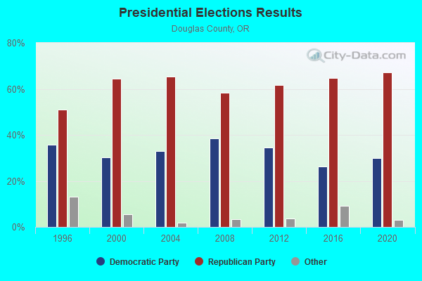
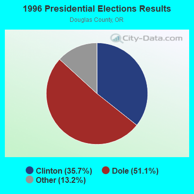
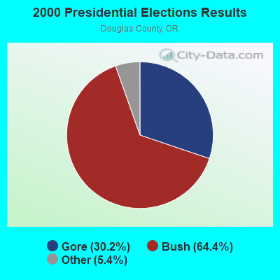
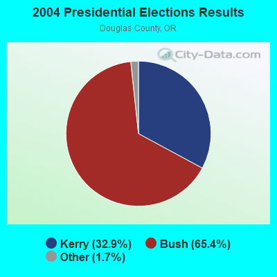
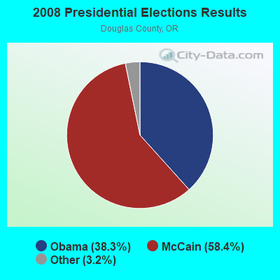
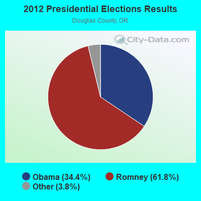
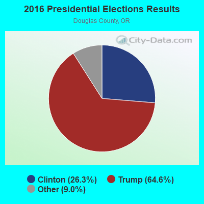

Graphs represent county-level data. Detailed 2008 Election Results
Religion statistics for South Umpqua, OR (based on Douglas County data)
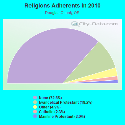
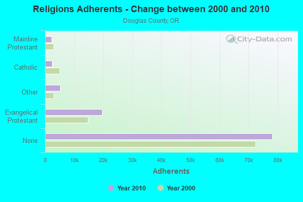
| Religion | Adherents | Congregations |
|---|---|---|
| Evangelical Protestant | 19,604 | 128 |
| Other | 5,238 | 25 |
| Catholic | 2,443 | 5 |
| Mainline Protestant | 2,206 | 25 |
| None | 78,176 | - |
Food Environment Statistics:
| Here: | 2.88 / 10,000 pop. |
| Oregon: | 2.03 / 10,000 pop. |
| Douglas County: | 0.38 / 10,000 pop. |
| Oregon: | 0.33 / 10,000 pop. |
| Douglas County: | 3.56 / 10,000 pop. |
| State: | 2.01 / 10,000 pop. |
| This county: | 2.98 / 10,000 pop. |
| Oregon: | 1.69 / 10,000 pop. |
| Douglas County: | 9.04 / 10,000 pop. |
| Oregon: | 9.93 / 10,000 pop. |
| Douglas County: | 10.3% |
| State: | 7.4% |
| This county: | 32.1% |
| Oregon: | 25.6% |
| This county: | 11.4% |
| Oregon: | 14.2% |
Strongest AM radio stations in South Umpqua:
- KGRV (700 AM; 25 kW; WINSTON, OR; Owner: PACIFIC CASCADE COMMUNICATIONS CORP.)
- KPNW (1120 AM; 50 kW; EUGENE, OR; Owner: CAPSTAR TX LIMITED PARTNERSHIP)
- KDUN (1030 AM; 50 kW; REEDSPORT, OR; Owner: PAMPLIN BROADCASTING-OREGON, INC.)
- KAPL (1300 AM; 20 kW; PHOENIX, OR; Owner: APPLEGATE MEDIA, INC.)
- KAJO (1270 AM; 10 kW; GRANTS PASS, OR; Owner: GRANTS PASS BROADCASTING CORPORATION)
- KTBR (950 AM; 3 kW; ROSEBURG, OR; Owner: JPR FOUNDATION INC.)
- KTMT (580 AM; 10 kW; ASHLAND, OR; Owner: MAPLETON COMMUNICATIONS, LLC)
- KRTA (610 AM; 5 kW; MEDFORD, OR; Owner: OPUS BROADCASTING SYSTEMS, INC.)
- KAGI (930 AM; 5 kW; GRANTS PASS, OR; Owner: SOUTHERN OREGON STATE COLLEGE)
- KPOJ (620 AM; 50 kW; PORTLAND, OR; Owner: CITICASTERS LICENSES, L.P.)
- KXL (750 AM; 50 kW; PORTLAND, OR; Owner: ROSE CITY RADIO CORPORATION)
- KWRO (630 AM; 5 kW; COQUILLE, OR; Owner: COQUILLE RIVER BROADCASTERS, INC.)
- KMED (1440 AM; 5 kW; MEDFORD, OR; Owner: CITICASTERS LICENSES, L.P.)
Strongest FM radio stations in South Umpqua:
- KSOR (90.1 FM; ASHLAND, OR; Owner: OREGON STATE BOARD OF HIGHER EDUC.)
- K205DM (88.9 FM; GLIDE, OR; Owner: CALVARY CHAPEL OF TWIN FALLS, INC.)
- K222AF (92.3 FM; AZALEA, OR; Owner: FAMILY LIFE BROADCASTING, INC.)
- K232DB (94.3 FM; MYRTLE CREEK, OR; Owner: RAIDER COMMUNICATIONS, INC.)
- K255AJ (98.9 FM; MYRTLE CREEK, OR; Owner: RAIDER COMMUNICATIONS, INC.)
- KLOV-FM (89.3 FM; WINCHESTER, OR; Owner: EDUCATIONAL MEDIA FOUNDATION)
- K261BF (100.1 FM; BLACK BUTTE, ETC., OR; Owner: FAMILY STATIONS, INC.)
- KKMX (104.3 FM; TRI CITY, OR; Owner: BROOKE COMMUNICATIONS, INC.)
- K259AE (99.7 FM; WOLF CREEK, OR; Owner: GRANTS PASS BROADCASTING CORPORATION)
- KLDZ (103.5 FM; MEDFORD, OR; Owner: CITICASTERS LICENSES, L.P.)
- KRRM (94.7 FM; ROGUE RIVER, OR; Owner: SHIRLEY M. BELL)
- K290AF (105.9 FM; ROGUE RIVER, OR; Owner: CITICASTERS LICENSES, L.P.)
- K266AC (101.1 FM; ROGUE RIVER, OR; Owner: CITICASTERS LICENSES, L.P.)
- KROG (96.9 FM; GRANTS PASS, OR; Owner: OPUS BROADCASTING SYSTEMS, INC.)
- KLDR (98.3 FM; HARBECK-FRUITDALE, OR; Owner: GRANTS PASS BROADCASTING CORP.)
- KKRB (106.9 FM; KLAMATH FALLS, OR; Owner: WYNNE BROADCASTING COMPANY, INC.)
- KAKT (105.1 FM; PHOENIX, OR; Owner: MAPLETON COMMUNICATIONS, LLC)
- KTMT-FM (93.7 FM; MEDFORD, OR; Owner: MAPLETON COMMUNICATIONS, LLC)
- K249BS (97.7 FM; GRANTS PASS, OR; Owner: CALVARY CHAPEL OF TWIN FALLS, INC.)
- KAVJ (101.1 FM; SUTHERLIN, OR; Owner: BROOKE COMMUNICATIONS, INC.)
TV broadcast stations around South Umpqua:
- KOBI (Channel 5; MEDFORD, OR; Owner: CALIFORNIA OREGON BROADCASTING, INC.)

- 43.5%Wood
- 31.4%Electricity
- 12.3%Fuel oil, kerosene, etc.
- 6.9%Bottled, tank, or LP gas
- 5.9%Utility gas

- 41.0%Electricity
- 31.9%Wood
- 11.6%Fuel oil, kerosene, etc.
- 7.9%Utility gas
- 6.0%Bottled, tank, or LP gas
- 1.2%Other fuel
- 0.4%No fuel used
South Umpqua compared to Oregon state average:
- Median household income below state average.
- Unemployed percentage below state average.
- Black race population percentage significantly below state average.
- Hispanic race population percentage significantly below state average.
- Median age above state average.
- Foreign-born population percentage significantly below state average.
- Length of stay since moving in significantly above state average.
- Number of rooms per house significantly below state average.
- House age significantly below state average.
- Number of college students below state average.
- Percentage of population with a bachelor's degree or higher significantly below state average.