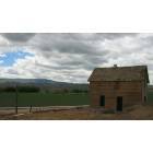
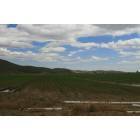
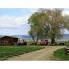
West Vale, Oregon
Submit your own pictures of this place and show them to the world
- OSM Map
- General Map
- Google Map
- MSN Map

| Males: 184 | |
| Females: 183 |
| Median resident age: | 40.2 years |
| Oregon median age: | 36.3 years |
Zip code: 97918
| West Vale: | $63,167 |
| OR: | $75,657 |
Estimated per capita income in 2022: $26,852 (it was $16,583 in 2000)
West Vale CCD income, earnings, and wages data
Estimated median house or condo value in 2022: $294,291 (it was $120,500 in 2000)
| West Vale: | $294,291 |
| OR: | $475,600 |
Mean prices in 2022: all housing units: $293,136; detached houses: $331,209; townhouses or other attached units: $383,119; in 2-unit structures: $143,001; mobile homes: $145,020; occupied boats, rvs, vans, etc.: $10,387
Detailed information about poverty and poor residents in West Vale, OR


- 34692.5%White alone
- 133.5%Hispanic
- 92.4%Two or more races
- 61.6%Asian alone

Races in West Vale detailed stats: ancestries, foreign born residents, place of birth
 Recent articles from our blog. Our writers, many of them Ph.D. graduates or candidates, create easy-to-read articles on a wide variety of topics.
Current Local Time: PST time zone
Land area: 25.5 square miles.
Population density: 14 people per square mile (very low).

| West Vale CCD: | 0.5% ($656) |
| Oregon: | 1.2% ($1,687) |
Nearest city with pop. 50,000+: Nampa, ID  (48.2 miles , pop. 51,867).
Nearest city with pop. 200,000+: Northwest Clackamas, OR (276.7 miles , pop. 224,220).
Nearest city with pop. 1,000,000+: Los Angeles, CA (685.1 miles , pop. 3,694,820).
Nearest cities:
), ), ), Latitude: 43.96 N, Longitude: 117.37 W
Area code commonly used in this area: 541


| Here: | 3.8% |
| Oregon: | 3.9% |

- Agriculture, forestry, fishing & hunting (22.6%)
- Construction (12.9%)
- Public administration (12.9%)
- Gasoline stations (9.7%)
- Machinery, equipment, supplies merchant wholesalers (5.6%)
- Accommodation & food services (5.6%)
- Nonmetallic mineral products (4.8%)

- Agriculture, forestry, fishing & hunting (36.4%)
- Construction (20.8%)
- Machinery, equipment, supplies merchant wholesalers (9.1%)
- Nonmetallic mineral products (7.8%)
- Administrative & support & waste management services (7.8%)
- Religious, grantmaking, civic, professional, similar organizations (7.8%)
- Machinery (5.2%)

- Public administration (34.0%)
- Gasoline stations (25.5%)
- Accommodation & food services (14.9%)
- Pharmacies & drug stores (12.8%)
- Other transportation, support activities, couriers (12.8%)

- Farmers and farm managers (16.1%)
- Agricultural workers, including supervisors (12.1%)
- Cashiers (9.7%)
- Carpenters (9.7%)
- Vehicle and mobile equipment mechanics, installers, and repairers (5.6%)
- Building and grounds cleaning and maintenance occupations (4.8%)
- Other food preparation and serving workers, including supervisors (4.8%)

- Farmers and farm managers (26.0%)
- Carpenters (15.6%)
- Agricultural workers, including supervisors (10.4%)
- Vehicle and mobile equipment mechanics, installers, and repairers (9.1%)
- Other management occupations, except farmers and farm managers (7.8%)
- Other food preparation and serving workers, including supervisors (7.8%)
- Building and grounds cleaning and maintenance occupations (7.8%)

- Cashiers (25.5%)
- Agricultural workers, including supervisors (14.9%)
- Accountants and auditors (12.8%)
- Health technologists and technicians (12.8%)
- Bus drivers (12.8%)
- Law enforcement workers, including supervisors (10.6%)
- Operations specialties managers, except financial managers (0.0%)
Average climate in West Vale, Oregon
Based on data reported by over 4,000 weather stations


Earthquake activity:
West Vale-area historical earthquake activity is significantly above Oregon state average. It is 2240% greater than the overall U.S. average.On 10/3/1915 at 06:52:48, a magnitude 7.6 (7.6 UK, Class: Major, Intensity: VIII - XII) earthquake occurred 239.5 miles away from West Vale center
On 10/28/1983 at 14:06:06, a magnitude 7.3 (6.2 MB, 7.3 MS, 7.0 MW) earthquake occurred 177.5 miles away from West Vale center, causing 2 deaths (2 shaking deaths) and 3 injuries, causing $15,000,000 total damage
On 8/18/1959 at 06:37:13, a magnitude 7.7 (7.7 UK) earthquake occurred 335.0 miles away from West Vale center, causing $26,000,000 total damage
On 3/31/2020 at 23:52:30, a magnitude 6.5 (6.5 MW, Depth: 7.5 mi, Class: Strong, Intensity: VII - IX) earthquake occurred 116.9 miles away from the city center
On 12/16/1954 at 11:07:12, a magnitude 7.0 (7.0 UK) earthquake occurred 330.9 miles away from West Vale center
On 4/13/1949 at 19:55:42, a magnitude 7.0 (7.0 UK) earthquake occurred 336.7 miles away from West Vale center, causing $80,000,000 total damage
Magnitude types: body-wave magnitude (MB), surface-wave magnitude (MS), moment magnitude (MW)
Natural disasters:
The number of natural disasters in Malheur County (5) is a lot smaller than the US average (15).Major Disasters (Presidential) Declared: 3
Emergencies Declared: 2
Causes of natural disasters: Drought: 1, Flood: 1, Heavy Rain: 1, Hurricane: 1, Winter Storm: 1, Other: 1 (Note: some incidents may be assigned to more than one category).
Colleges/universities with over 2000 students nearest to West Vale:
- Treasure Valley Community College (about 21 miles; Ontario, OR; Full-time enrollment: 2,055)
- Northwest Nazarene University (about 49 miles; Nampa, ID; FT enrollment: 2,290)
- College of Western Idaho (about 50 miles; Nampa, ID; FT enrollment: 6,300)
- Boise State University (about 64 miles; Boise, ID; FT enrollment: 16,774)
- Eastern Oregon University (about 101 miles; La Grande, OR; FT enrollment: 3,127)
- Walla Walla Community College (about 154 miles; Walla Walla, WA; FT enrollment: 4,263)
- Lewis-Clark State College (about 171 miles; Lewiston, ID; FT enrollment: 3,199)
Points of interest:
| This place: | 2.8 people |
| Oregon: | 2.5 people |
| This place: | 55.2% |
| Whole state: | 66.3% |
| This place: | 6.0% |
| Whole state: | 6.3% |
No gay or lesbian households reported
| This place: | 3.3% |
| Whole state: | 11.6% |
For population 15 years and over in West Vale:

- Never married: 22.3%
- Now married: 61.0%
- Separated: 0.0%
- Widowed: 9.6%
- Divorced: 7.2%
For population 25 years and over in West Vale:
- High school or higher: 88.0%
- Bachelor's degree or higher: 5.3%
- Graduate or professional degree: 1.9%
- Unemployed: 6.8%
- Mean travel time to work (commute): 22.6 minutes


| Here: | 7.9 |
| Oregon average: | 11.5 |
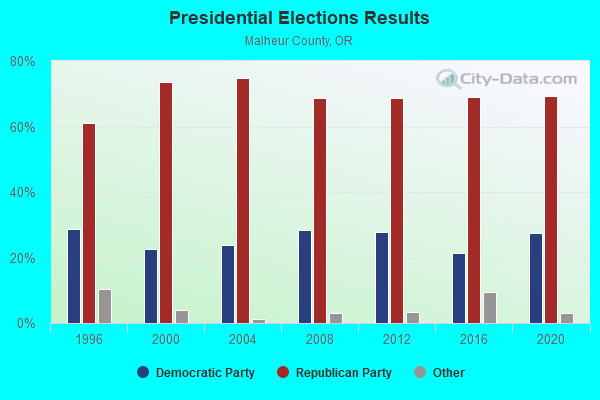
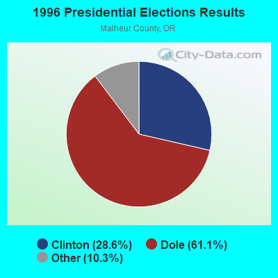
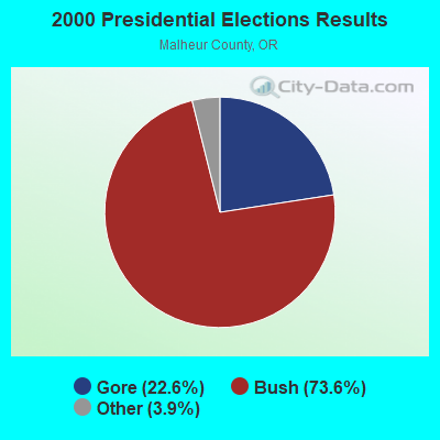

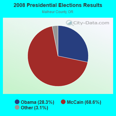
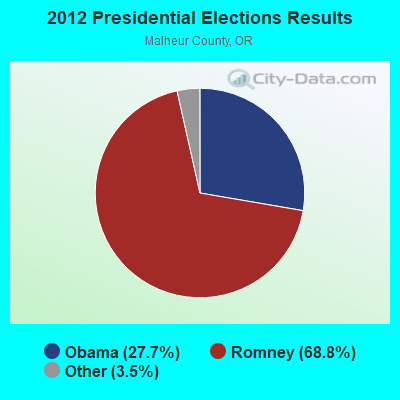
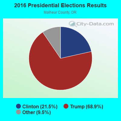
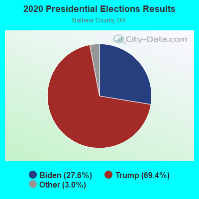
Graphs represent county-level data. Detailed 2008 Election Results
Religion statistics for West Vale, OR (based on Malheur County data)
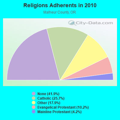
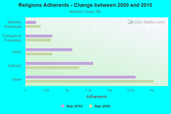
| Religion | Adherents | Congregations |
|---|---|---|
| Catholic | 8,060 | 7 |
| Other | 5,611 | 18 |
| Evangelical Protestant | 3,208 | 28 |
| Mainline Protestant | 1,304 | 13 |
| None | 13,130 | - |
Food Environment Statistics:
| Malheur County: | 1.61 / 10,000 pop. |
| Oregon: | 2.03 / 10,000 pop. |
| Malheur County: | 0.64 / 10,000 pop. |
| Oregon: | 0.33 / 10,000 pop. |
| This county: | 0.64 / 10,000 pop. |
| Oregon: | 2.01 / 10,000 pop. |
| Here: | 1.93 / 10,000 pop. |
| Oregon: | 1.69 / 10,000 pop. |
| Here: | 9.03 / 10,000 pop. |
| Oregon: | 9.93 / 10,000 pop. |
| This county: | 7.0% |
| Oregon: | 7.4% |
| Malheur County: | 29.7% |
| Oregon: | 25.6% |
| Malheur County: | 20.6% |
| Oregon: | 14.2% |
Strongest AM radio stations in West Vale:
- KWEI (1260 AM; 50 kW; WEISER, ID; Owner: TREASURE VALLEY BROADCASTING CO.)
- KBOI (670 AM; 50 kW; BOISE, ID; Owner: CITADEL BROADCASTING COMPANY)
- KSRV (1380 AM; 5 kW; ONTARIO, OR; Owner: HBG-RADIO ONTARIO LLC)
- KBSU (730 AM; 15 kW; BOISE, ID; Owner: IDAHO STATE BOARD OF EDUCATION)
- KBGN (1060 AM; daytime; 10 kW; CALDWELL, ID; Owner: NELSON M. AND KAREN E. WILSON)
- KIDO (580 AM; 5 kW; NAMPA, ID; Owner: CITICASTERS LICENSES, L.P.)
- KGEM (1140 AM; 10 kW; BOISE, ID; Owner: JOURNAL BROADCAST CORPORATION)
- KFXD (630 AM; 5 kW; BOISE, ID; Owner: CITICASTERS LICENSES, L.P.)
- KKIC (950 AM; 4 kW; BOISE, ID; Owner: WESTERN PACIFIC, INC)
- KIOV (1450 AM; 1 kW; PAYETTE, ID; Owner: ASSOCIATES COMMUNICATIONS OF IDAHO,)
- KTIK (1350 AM; 5 kW; NAMPA, ID; Owner: CITADEL BROADCASTING COMPANY)
- KPOJ (620 AM; 50 kW; PORTLAND, OR; Owner: CITICASTERS LICENSES, L.P.)
- KTBI (810 AM; daytime; 50 kW; EPHRATA, WA; Owner: TACOMA BROADCASTERS, INCORPORATED)
Strongest FM radio stations in West Vale:
- KJHY (101.9 FM; EMMETT, ID; Owner: CAPITAL WEST INC)
- KWEI-FM (99.5 FM; FRUITLAND, ID; Owner: TREASURE VALLEY BROADCASTING CO.)
- K298AC (107.5 FM; ONTARIO, OR; Owner: OREGON PUBLIC BROADCASTING)
- KIZN (92.3 FM; BOISE, ID; Owner: CITADEL BROADCASTING COMPANY)
- KKGL (96.9 FM; NAMPA, ID; Owner: CITADEL BROADCASTING COMPANY)
- KQFC (97.9 FM; BOISE, ID; Owner: CITADEL BROADCASTING COMPANY)
- KZMG (93.1 FM; NEW PLYMOUTH, ID; Owner: CITADEL BROADCASTING COMPANY)
- KBSU-FM (90.3 FM; BOISE, ID; Owner: IDAHO STATE BOARD OF EDUCATION)
- KBSX (91.5 FM; BOISE, ID; Owner: IDAHO STATE BOARD OF EDUCATION)
- KCIX (105.9 FM; GARDEN CITY, ID; Owner: CITICASTERS LICENSES, L.P.)
- KRVB (94.9 FM; NAMPA, ID; Owner: JOURNAL BROADCAST CORPORATION)
- KXLT-FM (107.9 FM; EAGLE, ID; Owner: CITICASTERS LICENSES, L.P.)
- KJOT (105.1 FM; BOISE, ID; Owner: JOURNAL BROADCAST CORPORATION)
- KTHI (107.1 FM; CALDWELL, ID; Owner: JOURNAL BROADCAST CORPORATION)
- KBXL (94.1 FM; CALDWELL, ID; Owner: KSPD, INC.)
- KTSY (89.5 FM; CALDWELL, ID; Owner: GEM STATE ADVENTIST ACADEMY)
- KSAS-FM (103.3 FM; CALDWELL, ID; Owner: CITICASTERS LICENSES, L.P.)
- KLTB (104.3 FM; BOISE, ID; Owner: CITICASTERS LICENSES, L.P.)
TV broadcast stations around West Vale:
- KMBA-LP (Channel 19; ONTARIO, OR; Owner: TREASURE VALLEY COMMUNITY COLLEGE)
- K11MK (Channel 11; VALE, OR; Owner: CITY OF VALE)
- K13NC (Channel 13; VALE, OR; Owner: CITY OF VALE)

- 73.1%Electricity
- 14.4%Fuel oil, kerosene, etc.
- 12.5%Bottled, tank, or LP gas

- 48.1%Wood
- 25.9%Electricity
- 25.9%Fuel oil, kerosene, etc.
West Vale compared to Oregon state average:
- Median house value below state average.
- Unemployed percentage below state average.
- Black race population percentage significantly below state average.
- Hispanic race population percentage significantly below state average.
- Foreign-born population percentage significantly below state average.
- Renting percentage significantly below state average.
- Length of stay since moving in significantly above state average.
- Number of rooms per house significantly below state average.
- House age significantly below state average.
- Number of college students below state average.
- Percentage of population with a bachelor's degree or higher significantly below state average.