Bridge Statistics for Auburn Hills, Michigan (MI)
Condition, Traffic, Stress, Structural Evaluation, Project Costs
- National Bridge Inventory (NBI) Statistics
- 74Number of bridges
- 827ft / 252mTotal length
- $611,000Total costs
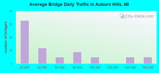
- 3,318,987Total average daily traffic
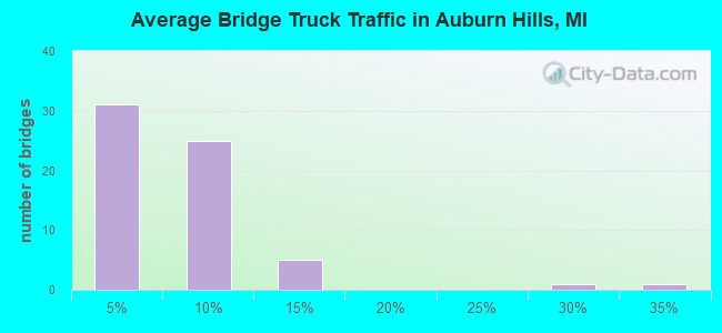
- 167,938Total average daily truck traffic
- National Bridge Inventory (NBI) Registered Bridges for Auburn Hills
- No street view available for this location
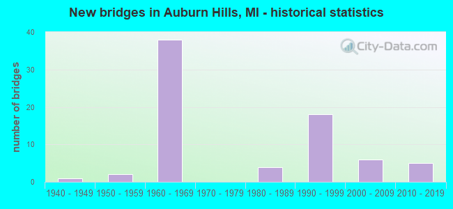
- New bridges - historical statistics
- 11940-1949
- 21950-1959
- 381960-1969
- 41980-1989
- 181990-1999
- 62000-2009
- 52010-2019
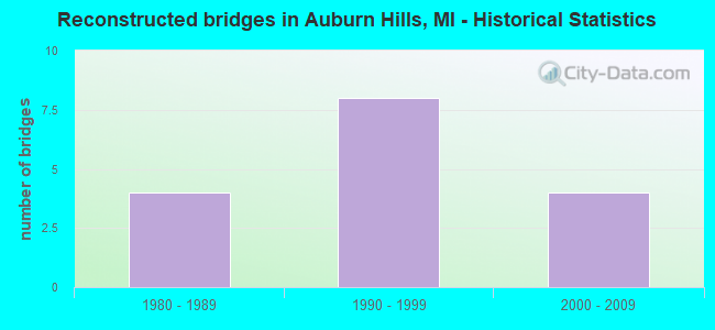
- Reconstructed bridges - Historical Statistics
- 41980-1989
- 81990-1999
- 42000-2009
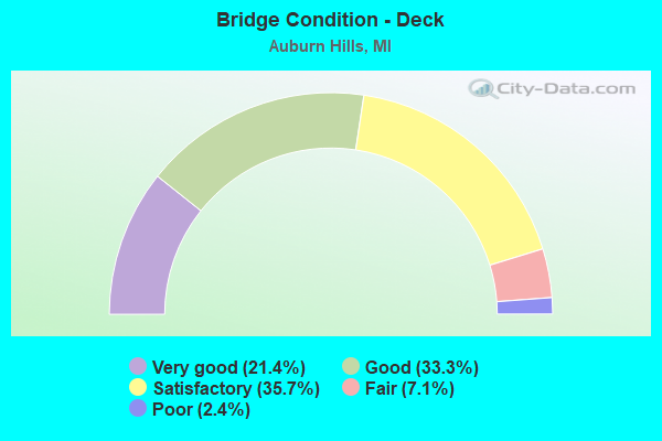
- Bridge Condition - Deck
- 21.4%Very good
- 33.3%Good
- 35.7%Satisfactory
- 7.1%Fair
- 2.4%Poor
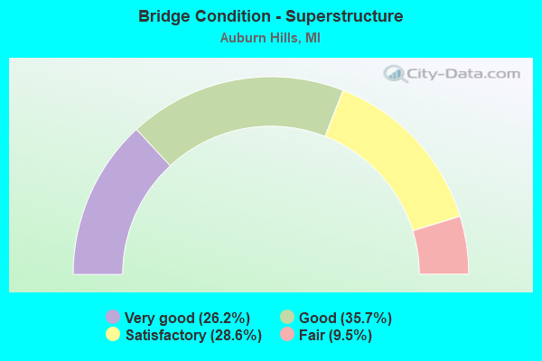
- Bridge Condition - Superstructure
- 26.2%Very good
- 35.7%Good
- 28.6%Satisfactory
- 9.5%Fair
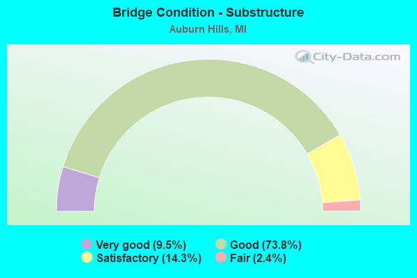
- Bridge Condition - Substructure
- 9.5%Very good
- 73.8%Good
- 14.3%Satisfactory
- 2.4%Fair
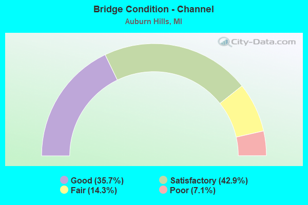
- Bridge Condition - Channel
- 35.7%Good
- 42.9%Satisfactory
- 14.3%Fair
- 7.1%Poor
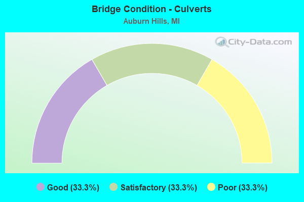
- Bridge Condition - Culverts
- 33.3%Good
- 33.3%Satisfactory
- 33.3%Poor
Find on map >> Show street view
Structure Number: 8, Location: 2 MI N OF DEERTON (Lat: 46.507042, Lng: -87.037278), Route carried "on" structure: Other road , Year Built: 1958, Year Reconstructed: 2011, Status: Posted for load, Structure Length: 0.94m (3.08ft), Average Daily Traffic: 6 (year 1995), Average Future Daily Traffic: 10 (year 2015), Features Intersected: LAUGHING WHITEFISH RIVER, Facility Carried by Structure: RISKU FARM ROAD
Minimum Vertical Clearance: 30.48m (100.00ft), Kilometerpoint: 0.415, Lanes on structure: 2, Owner: County Highway Agency, Approaching Roadway Width: 4.2m (13.8ft), Material/Design: Steel, Design/Construction: Stringer/Multi-beam, Number Of Spans In Main Unit: 1, Length of Maximum Span: 7.0m (23.0ft), Curb-To-Curb Width: 3.5m (11.5ft), Out-to-Out Width: 3.9m (12.8ft)
Condition: Deck: Good, Superstructure: Very good, Substructure: Fair, Channel: Satisfactory, Operating Rating: 22.0 metric tons, Method Used To Determine Operating Rating: Load and Resistance Factor Rating (LRFR) rating reported by rating factor(RF) method using HL-93 loadings, Inventory Rating: 16.8 metric tons, Method Used To Determine Inventory Rating: Load and Resistance Factor Rating (LRFR) rating reported by rating factor(RF) method using HL-93 loadings, Structural Evaluation: Somewhat better than minimum adequacy, Waterway Adequacy: High priority of corrective action, Approach Roadway Alignment: High priority of corrective action, Bridge Posting: Required (Relationship of Operating Rating to Maximum Legal Load: > 39.9% below), Length Of Structure Improvement: 1.37m (4.49ft), Designated Inspection Frequency: Every 24 months, Inspection Date: September 2021, Bridge Improvement Cost: $135,000, Roadway Improvement Cost: $15,000, Total Project Cost: $175,000, Deck Structure Type: Wood or Timber, Wearing Surface/Protective System: Wearing Surface: Wood or Timber
Find on map >> Show street view
Structure Number: 784, Location: 2.1 MI NE OF STEVENSVILLE (Lat: 42.039867, Lng: -86.502031), Route carried "on" structure: Interstate 94, Year Built: 2015, Status: Open, Structure Length: 4.36m (14.30ft), Average Daily Traffic: 22,145 (year 2007), Truck Traffic: 28%, Average Future Daily Traffic: 31,354 (year 2018), Design Load: Greater than HL93, Features Intersected: HICKORY CREEK
Minimum Vertical Clearance: 30.48m (100.00ft), Kilometerpoint: 39.002, Lanes on structure: 3, Base Highway Network: Yes (Inventory Route: 136, Subroute: 4), Owner: State Highway Agency, Approaching Roadway Width: 18.3m (60.0ft), Skew: 4 degrees, Material/Design: Steel, Design/Construction: Stringer/Multi-beam, Number Of Spans In Main Unit: 1, Length of Maximum Span: 41.1m (134.8ft), Curb-To-Curb Width: 18.3m (60.0ft), Out-to-Out Width: 19.2m (63.0ft)
Condition: Deck: Good, Superstructure: Good, Substructure: Very good, Channel: Fair, Operating Rating: 55.4 metric tons, Method Used To Determine Operating Rating: Load and Resistance Factor Rating (LRFR) rating reported by rating factor(RF) method using HL-93 loadings, Inventory Rating: 42.8 metric tons, Method Used To Determine Inventory Rating: Load and Resistance Factor Rating (LRFR) rating reported by rating factor(RF) method using HL-93 loadings, Structural Evaluation: Better than present minimum criteria, Deck Geometry: Better than present minimum criteria, Waterway Adequacy: Better than present minimum criteria, Approach Roadway Alignment: Equal to present desirable criteria, Designated Inspection Frequency: Every 24 months, Inspection Date: August 2020, Deck Structure Type: Concrete Cast-file-Place, Wearing Surface/Protective System: Wearing Surface: Monolithic Concrete, Deck Protection: Epoxy Coated Reinforcing
Find on map >> Show street view
Structure Number: 801, Location: 0.9 MI E OF UNION PIER (Lat: 41.827967, Lng: -86.673478), Route carried "on" structure: County highway 1110, Year Built: 1962, Status: Open, Structure Length: 11.95m (39.21ft), Average Daily Traffic: 159 (year 2016), Truck Traffic: 2%, Average Future Daily Traffic: 183 (year 2036), Design Load: HS 20, Features Intersected: I-94, Facility Carried by Structure: UNION PIER ROAD
Minimum Vertical Clearance: 30.48m (100.00ft), Kilometerpoint: 2.556, Lanes on structure: 2, Lanes under structure: 6, Owner: State Highway Agency, Approaching Roadway Width: 10.2m (33.5ft), Skew: 5 degrees, Material/Design: Steel, Design/Construction: Stringer/Multi-beam, Number Of Spans In Main Unit: 4, Length of Maximum Span: 35.4m (116.1ft), Curb-To-Curb Width: 9.8m (32.2ft), Out-to-Out Width: 10.6m (34.8ft)
Condition: Deck: Satisfactory, Superstructure: Fair, Substructure: Good, Operating Rating: 81.6 metric tons, Method Used To Determine Operating Rating: Load Factor (LF) rating reported by rating factor (RF) method using MS18 loading, Inventory Rating: 48.6 metric tons, Method Used To Determine Inventory Rating: Load Factor (LF) rating reported by rating factor (RF) method using MS18 loading, Structural Evaluation: Somewhat better than minimum adequacy, Deck Geometry: Better than present minimum criteria, Underclear: Meets minimum limits, Approach Roadway Alignment: Equal to present desirable criteria, Designated Inspection Frequency: Every 24 months, Inspection Date: October 2020, Deck Structure Type: Concrete Cast-file-Place, Wearing Surface/Protective System: Wearing Surface: Epoxy Overlay
Find on map >> Show street view
Structure Number: 7827, Location: 1.3 MI W OF AUBURN HTS (Lat: 42.635289, Lng: -83.246461), Route carried "on" structure: City street 2059, Year Built: 1947, Year Reconstructed: 2003, Status: Open, Structure Length: 1.67m (5.48ft), Average Daily Traffic: 13,000 (year 1995), Truck Traffic: 5%, Average Future Daily Traffic: 15,815 (year 2015), Design Load: HS 20, Features Intersected: CLINTON RIVER, Facility Carried by Structure: OLD M-59
Minimum Vertical Clearance: 30.48m (100.00ft), Kilometerpoint: 3.673, Lanes on structure: 3, Owner: City or Municipal Highway Agency, Approaching Roadway Width: 13.4m (44.0ft), Skew: 3 degrees, Material/Design: Steel, Design/Construction: Stringer/Multi-beam, Number Of Spans In Main Unit: 1, Length of Maximum Span: 16.7m (54.8ft), Curb or Sidewalk Widths: Left: 1.8m (5.9ft), Right: 0.0m, Curb-To-Curb Width: 13.4m (44.0ft), Out-to-Out Width: 16.1m (52.8ft)
Condition: Deck: Very good, Superstructure: Good, Substructure: Good, Channel: Satisfactory, Operating Rating: 92.3 metric tons, Method Used To Determine Operating Rating: Load Factor (LF) rating reported by rating factor (RF) method using MS18 loading, Inventory Rating: 55.1 metric tons, Method Used To Determine Inventory Rating: Load Factor (LF) rating reported by rating factor (RF) method using MS18 loading, Structural Evaluation: Better than present minimum criteria, Deck Geometry: Somewhat better than minimum adequacy, Waterway Adequacy: Equal to present desirable criteria, Approach Roadway Alignment: Equal to present desirable criteria, Designated Inspection Frequency: Every 24 months, Inspection Date: October 2020, Deck Structure Type: Concrete Cast-file-Place, Wearing Surface/Protective System: Wearing Surface: Monolithic Concrete, Deck Protection: Epoxy Coated Reinforcing
Find on map >> Show street view
Structure Number: 7828, Location: IN AUBURN HTS (Lat: 42.633594, Lng: -83.224308), Route carried "on" structure: City street 2059, Year Built: 1952, Year Reconstructed: 2001, Status: Open, Structure Length: 1.37m (4.49ft), Average Daily Traffic: 16,000 (year 1995), Truck Traffic: 4%, Average Future Daily Traffic: 15,283 (year 2015), Design Load: HS 20, Features Intersected: CLINTON RIVER, Facility Carried by Structure: OLD M-59(AUBURN R)
Minimum Vertical Clearance: 30.48m (100.00ft), Kilometerpoint: 5.512, Lanes on structure: 3, Owner: City or Municipal Highway Agency, Approaching Roadway Width: 14.0m (45.9ft), Material/Design: Steel, Design/Construction: Stringer/Multi-beam, Number Of Spans In Main Unit: 1, Length of Maximum Span: 13.7m (44.9ft), Curb or Sidewalk Widths: Left: 4.4m (14.4ft), Right: 2.7m (8.9ft), Curb-To-Curb Width: 13.1m (43.0ft), Out-to-Out Width: 20.9m (68.6ft)
Condition: Deck: Good, Superstructure: Satisfactory, Substructure: Good, Channel: Good, Operating Rating: 75.2 metric tons, Method Used To Determine Operating Rating: Load Factor (LF) rating reported by rating factor (RF) method using MS18 loading, Inventory Rating: 45.0 metric tons, Method Used To Determine Inventory Rating: Load Factor (LF) rating reported by rating factor (RF) method using MS18 loading, Structural Evaluation: Equal to present minimum criteria, Deck Geometry: Meets minimum limits, Waterway Adequacy: Superior to present desirable criteria, Approach Roadway Alignment: Equal to present desirable criteria, Designated Inspection Frequency: Every 24 months, Inspection Date: October 2020, Deck Structure Type: Concrete Cast-file-Place, Wearing Surface/Protective System: Wearing Surface: Bituminous
Find on map >> Show street view
Structure Number: 7834, Location: 1.2 MI E OF I-75 (Lat: 42.644108, Lng: -83.213908), Route carried "on" structure: State highway 59, Year Built: 1966, Year Reconstructed: 1999, Status: Open, Structure Length: 1.76m (5.77ft), Average Daily Traffic: 40,528 (year 2007), Truck Traffic: 3%, Average Future Daily Traffic: 41,641 (year 2018), Design Load: HS 25 or greater, Features Intersected: CLINTON RIVER
Minimum Vertical Clearance: 30.48m (100.00ft), Kilometerpoint: 5.729, Lanes on structure: 3, Base Highway Network: Yes (Inventory Route: 67, Subroute: 8), Owner: State Highway Agency, Approaching Roadway Width: 21.0m (68.9ft), Skew: 2 degrees, Material/Design: Prestressed concrete, Design/Construction: Stringer/Multi-beam, Number Of Spans In Main Unit: 1, Length of Maximum Span: 17.6m (57.7ft), Curb-To-Curb Width: 30.6m (100.4ft), Out-to-Out Width: 31.6m (103.7ft)
Condition: Deck: Satisfactory, Superstructure: Good, Substructure: Good, Channel: Good, Operating Rating: 65.6 metric tons, Method Used To Determine Operating Rating: Load Factor (LF), Inventory Rating: 39.0 metric tons, Method Used To Determine Inventory Rating: Load Factor (LF), Structural Evaluation: Better than present minimum criteria, Deck Geometry: Superior to present desirable criteria, Waterway Adequacy: Equal to present desirable criteria, Approach Roadway Alignment: Equal to present desirable criteria, Designated Inspection Frequency: Every 24 months, Inspection Date: May 2021, Deck Structure Type: Concrete Cast-file-Place, Wearing Surface/Protective System: Wearing Surface: Latex Concrete, Deck Protection: Epoxy Coated Reinforcing
Find on map >> Show street view
Structure Number: 784, Location: PONTIAC TWP SEC 25 (Lat: 42.643436, Lng: -83.219642), Route carried "on" structure: City street , Year Built: 1999, Status: Open, Structure Length: 10.97m (35.99ft), Average Daily Traffic: 9,820 (year 1997), Truck Traffic: 3%, Average Future Daily Traffic: 24,300 (year 2015), Design Load: HS 20, Features Intersected: M-59, Facility Carried by Structure: SQUIRREL RD NB
Minimum Vertical Clearance: 30.48m (100.00ft), Kilometerpoint: 1.061, Lanes on structure: 3, Lanes under structure: 6, Owner: State Highway Agency, Approaching Roadway Width: 15.5m (50.9ft), Material/Design: Prestressed concrete, Design/Construction: Box Beam or Girders - Multiple, Number Of Spans In Main Unit: 4, Length of Maximum Span: 42.1m (138.1ft), Curb-To-Curb Width: 15.5m (50.9ft), Out-to-Out Width: 16.6m (54.5ft)
Condition: Deck: Satisfactory, Superstructure: Satisfactory, Substructure: Good, Operating Rating: 79.4 metric tons, Method Used To Determine Operating Rating: Load Factor (LF) rating reported by rating factor (RF) method using MS18 loading, Inventory Rating: 28.8 metric tons, Method Used To Determine Inventory Rating: Load Factor (LF) rating reported by rating factor (RF) method using MS18 loading, Structural Evaluation: Equal to present minimum criteria, Deck Geometry: Equal to present minimum criteria, Underclear: Better than present minimum criteria, Approach Roadway Alignment: Equal to present desirable criteria, Designated Inspection Frequency: Every 24 months, Inspection Date: September 2020, Deck Structure Type: Concrete Cast-file-Place, Wearing Surface/Protective System: Wearing Surface: Monolithic Concrete, Deck Protection: Epoxy Coated Reinforcing
Find on map >> Show street view
Structure Number: 7996, Location: 5.7 MI NW OF M-59 (Lat: 42.703006, Lng: -83.286894), Route carried "on" structure: Interstate 75, Year Built: 1962, Status: Open, Structure Length: 4.39m (14.40ft), Average Daily Traffic: 36,813 (year 2019), Truck Traffic: 5%, Average Future Daily Traffic: 39,088 (year 2039), Design Load: HS 20+Mod, Features Intersected: GTW RR
Minimum Vertical Clearance: 30.48m (100.00ft), Kilometerpoint: 39.055, Lanes on structure: 3, Base Highway Network: Yes (Inventory Route: 64, Subroute: 8), Owner: State Highway Agency, Approaching Roadway Width: 18.0m (59.1ft), Material/Design: Prestressed concrete, Design/Construction: Stringer/Multi-beam, Number Of Spans In Main Unit: 3, Length of Maximum Span: 14.6m (47.9ft), Curb-To-Curb Width: 17.7m (58.1ft), Out-to-Out Width: 19.0m (62.3ft)
Condition: Deck: Good, Superstructure: Very good, Substructure: Good, Operating Rating: 75.8 metric tons, Method Used To Determine Operating Rating: Load Factor (LF) rating reported by rating factor (RF) method using MS18 loading, Inventory Rating: 45.4 metric tons, Method Used To Determine Inventory Rating: Load Factor (LF) rating reported by rating factor (RF) method using MS18 loading, Structural Evaluation: Better than present minimum criteria, Deck Geometry: Better than present minimum criteria, Approach Roadway Alignment: Equal to present desirable criteria, Designated Inspection Frequency: Every 24 months, Inspection Date: March 2021, Deck Structure Type: Concrete Cast-file-Place, Wearing Surface/Protective System: Wearing Surface: Epoxy Overlay
Find on map >> Show street view
Structure Number: 7997, Location: 5.7 MI NW OF M-59 (Lat: 42.702783, Lng: -83.287081), Route carried "on" structure: Interstate 75, Year Built: 1962, Status: Open, Structure Length: 4.39m (14.40ft), Average Daily Traffic: 36,813 (year 2019), Truck Traffic: 5%, Average Future Daily Traffic: 39,088 (year 2039), Design Load: HS 20+Mod, Features Intersected: GTW RR
Minimum Vertical Clearance: 30.48m (100.00ft), Kilometerpoint: 39.152, Lanes on structure: 3, Base Highway Network: Yes (Inventory Route: 64, Subroute: 6), Owner: State Highway Agency, Approaching Roadway Width: 12.8m (42.0ft), Material/Design: Prestressed concrete, Design/Construction: Stringer/Multi-beam, Number Of Spans In Main Unit: 3, Length of Maximum Span: 14.6m (47.9ft), Curb-To-Curb Width: 17.7m (58.1ft), Out-to-Out Width: 19.0m (62.3ft)
Condition: Deck: Good, Superstructure: Very good, Substructure: Good, Operating Rating: 75.5 metric tons, Method Used To Determine Operating Rating: Load Factor (LF) rating reported by rating factor (RF) method using MS18 loading, Inventory Rating: 45.0 metric tons, Method Used To Determine Inventory Rating: Load Factor (LF) rating reported by rating factor (RF) method using MS18 loading, Structural Evaluation: Better than present minimum criteria, Deck Geometry: Better than present minimum criteria, Underclear: Somewhat better than minimum adequacy, Approach Roadway Alignment: Equal to present desirable criteria, Designated Inspection Frequency: Every 24 months, Inspection Date: March 2021, Deck Structure Type: Concrete Cast-file-Place, Wearing Surface/Protective System: Wearing Surface: Epoxy Overlay
Find on map >> Show street view
Structure Number: 7998, Location: 5.7 MI NW OF M-59 (Lat: 42.703092, Lng: -83.286817), Route carried "on" structure: Ramp Interstate 75, Year Built: 1981, Year Reconstructed: 2005, Status: Open, Structure Length: 4.41m (14.47ft), Average Daily Traffic: 5,075 (year 2019), Truck Traffic: 11%, Average Future Daily Traffic: 5,375 (year 2039), Design Load: HS 25 or greater, Features Intersected: GTW RR
Minimum Vertical Clearance: 30.48m (100.00ft), Kilometerpoint: 0.172, Lanes on structure: 1, Owner: State Highway Agency, Approaching Roadway Width: 9.7m (31.8ft), Material/Design: Prestressed concrete, Design/Construction: Stringer/Multi-beam, Number Of Spans In Main Unit: 3, Length of Maximum Span: 14.8m (48.6ft), Curb-To-Curb Width: 7.9m (25.9ft), Out-to-Out Width: 9.1m (29.9ft)
Condition: Deck: Good, Superstructure: Very good, Substructure: Good, Operating Rating: 53.1 metric tons, Method Used To Determine Operating Rating: Load Factor (LF) rating reported by rating factor (RF) method using MS18 loading, Inventory Rating: 31.8 metric tons, Method Used To Determine Inventory Rating: Load Factor (LF) rating reported by rating factor (RF) method using MS18 loading, Structural Evaluation: Better than present minimum criteria, Deck Geometry: Equal to present desirable criteria, Approach Roadway Alignment: Equal to present desirable criteria, Designated Inspection Frequency: Every 24 months, Inspection Date: March 2021, Deck Structure Type: Concrete Cast-file-Place, Wearing Surface/Protective System: Wearing Surface: Latex Concrete, Deck Protection: Epoxy Coated Reinforcing
Find on map >> Show street view
Structure Number: 7999, Location: @ (M-59) E OF PONTIAC (Lat: 42.641744, Lng: -83.238242), Route carried "on" structure: Interstate 75, Year Built: 1963, Status: Open, Structure Length: 7.03m (23.06ft), Average Daily Traffic: 63,925 (year 2019), Truck Traffic: 6%, Average Future Daily Traffic: 67,875 (year 2039), Design Load: HS 20+Mod, Features Intersected: M-59
Minimum Vertical Clearance: 30.48m (100.00ft), Kilometerpoint: 29.838, Lanes on structure: 3, Lanes under structure: 8, Base Highway Network: Yes (Inventory Route: 64, Subroute: 8), Owner: State Highway Agency, Approaching Roadway Width: 21.1m (69.2ft), Material/Design: Steel, Design/Construction: Stringer/Multi-beam, Number Of Spans In Main Unit: 4, Length of Maximum Span: 24.8m (81.4ft), Curb-To-Curb Width: 22.0m (72.2ft), Out-to-Out Width: 23.0m (75.5ft)
Condition: Deck: Fair, Superstructure: Good, Substructure: Satisfactory, Operating Rating: 62.2 metric tons, Method Used To Determine Operating Rating: Load Factor (LF) rating reported by rating factor (RF) method using MS18 loading, Inventory Rating: 37.3 metric tons, Method Used To Determine Inventory Rating: Load Factor (LF) rating reported by rating factor (RF) method using MS18 loading, Structural Evaluation: Equal to present minimum criteria, Deck Geometry: Superior to present desirable criteria, Underclear: High priority of corrective action, Approach Roadway Alignment: Equal to present desirable criteria, Designated Inspection Frequency: Every 24 months, Inspection Date: July 2021, Deck Structure Type: Concrete Cast-file-Place, Wearing Surface/Protective System: Wearing Surface: Latex Concrete, Deck Protection: Epoxy Coated Reinforcing
Find on map >> Show street view
Structure Number: 8, Location: EAST OF PONTIAC (M-59) (Lat: 42.641494, Lng: -83.238597), Route carried "on" structure: Interstate 75, Year Built: 1963, Status: Open, Structure Length: 7.03m (23.06ft), Average Daily Traffic: 63,925 (year 2019), Truck Traffic: 6%, Average Future Daily Traffic: 67,875 (year 2039), Design Load: HS 20+Mod, Features Intersected: M-59
Minimum Vertical Clearance: 30.48m (100.00ft), Kilometerpoint: 29.953, Lanes on structure: 5, Lanes under structure: 8, Base Highway Network: Yes (Inventory Route: 64, Subroute: 6), Owner: State Highway Agency, Approaching Roadway Width: 21.1m (69.2ft), Material/Design: Steel, Design/Construction: Stringer/Multi-beam, Number Of Spans In Main Unit: 4, Length of Maximum Span: 24.8m (81.4ft), Curb-To-Curb Width: 22.0m (72.2ft), Out-to-Out Width: 23.0m (75.5ft)
Condition: Deck: Satisfactory, Superstructure: Good, Substructure: Good, Operating Rating: 61.9 metric tons, Method Used To Determine Operating Rating: Load Factor (LF) rating reported by rating factor (RF) method using MS18 loading, Inventory Rating: 36.9 metric tons, Method Used To Determine Inventory Rating: Load Factor (LF) rating reported by rating factor (RF) method using MS18 loading, Structural Evaluation: Better than present minimum criteria, Deck Geometry: Meets minimum limits, Underclear: Meets minimum limits, Approach Roadway Alignment: Equal to present desirable criteria, Length Of Structure Improvement: 7.04m (23.10ft), Designated Inspection Frequency: Every 24 months, Inspection Date: July 2021, Bridge Improvement Cost: $271,000, Roadway Improvement Cost: $24,000, Total Project Cost: $283,000, Deck Structure Type: Concrete Cast-file-Place, Wearing Surface/Protective System: Wearing Surface: Latex Concrete, Deck Protection: Cathodic Protection
Find on map >> Show street view
Structure Number: 8001, Location: 0.4 MI N.OF M-59 (Lat: 42.649333, Lng: -83.238100), Route carried "on" structure: City street 2059, Year Built: 1990, Status: Open, Structure Length: 13.41m (44.00ft), Average Daily Traffic: 12,250 (year 2019), Truck Traffic: 14%, Average Future Daily Traffic: 13,000 (year 2039), Design Load: HS 20, Features Intersected: I-75, Facility Carried by Structure: FEATHERSTONE RD EB
Minimum Vertical Clearance: 30.48m (100.00ft), Kilometerpoint: 0.979, Lanes on structure: 2, Lanes under structure: 9, Owner: State Highway Agency, Approaching Roadway Width: 8.8m (28.9ft), Material/Design: Prestressed concrete, Design/Construction: Stringer/Multi-beam, Number Of Spans In Main Unit: 4, Length of Maximum Span: 33.5m (109.9ft), Curb or Sidewalk Widths: Left: 0.0m, Right: 2.4m (7.9ft), Curb-To-Curb Width: 9.8m (32.2ft), Out-to-Out Width: 13.4m (44.0ft)
Condition: Deck: Good, Superstructure: Good, Substructure: Satisfactory, Operating Rating: 73.2 metric tons, Method Used To Determine Operating Rating: Load Factor (LF) rating reported by rating factor (RF) method using MS18 loading, Inventory Rating: 44.7 metric tons, Method Used To Determine Inventory Rating: Load Factor (LF) rating reported by rating factor (RF) method using MS18 loading, Structural Evaluation: Equal to present minimum criteria, Deck Geometry: Meets minimum limits, Underclear: Equal to present minimum criteria, Approach Roadway Alignment: Equal to present desirable criteria, Designated Inspection Frequency: Every 24 months, Inspection Date: July 2021, Deck Structure Type: Concrete Cast-file-Place, Wearing Surface/Protective System: Wearing Surface: Monolithic Concrete, Deck Protection: Epoxy Coated Reinforcing
Find on map >> Show street view
Structure Number: 8002, Location: 0.4 MI N. OF M-59 (Lat: 42.649328, Lng: -83.238453), Route carried "on" structure: City street 9230, Year Built: 1990, Status: Open, Structure Length: 13.41m (44.00ft), Average Daily Traffic: 12,250 (year 2019), Truck Traffic: 14%, Average Future Daily Traffic: 13,000 (year 2039), Design Load: HS 20, Features Intersected: I-75, Facility Carried by Structure: FEATHERSTONE RD WB
Minimum Vertical Clearance: 30.48m (100.00ft), Kilometerpoint: 0.956, Lanes on structure: 2, Lanes under structure: 9, Owner: State Highway Agency, Approaching Roadway Width: 8.8m (28.9ft), Material/Design: Prestressed concrete, Design/Construction: Stringer/Multi-beam, Number Of Spans In Main Unit: 4, Length of Maximum Span: 33.5m (109.9ft), Curb-To-Curb Width: 9.8m (32.2ft), Out-to-Out Width: 10.8m (35.4ft)
Condition: Deck: Satisfactory, Superstructure: Satisfactory, Substructure: Good, Operating Rating: 71.9 metric tons, Method Used To Determine Operating Rating: Load Factor (LF) rating reported by rating factor (RF) method using MS18 loading, Inventory Rating: 43.7 metric tons, Method Used To Determine Inventory Rating: Load Factor (LF) rating reported by rating factor (RF) method using MS18 loading, Structural Evaluation: Equal to present minimum criteria, Deck Geometry: Meets minimum limits, Underclear: Equal to present minimum criteria, Approach Roadway Alignment: Equal to present desirable criteria, Designated Inspection Frequency: Every 24 months, Inspection Date: July 2021, Deck Structure Type: Concrete Cast-file-Place, Wearing Surface/Protective System: Wearing Surface: Monolithic Concrete, Deck Protection: Epoxy Coated Reinforcing
Find on map >> Show street view
Structure Number: 8004, Location: 2.0 MI N OF M-59 (Lat: 42.670944, Lng: -83.241017), Route carried "on" structure: Interstate 75, Year Built: 1963, Status: Open, Structure Length: 3.96m (12.99ft), Average Daily Traffic: 71,900 (year 2009), Truck Traffic: 4%, Average Future Daily Traffic: 80,300 (year 2029), Design Load: HS 20+Mod, Features Intersected: PONTIAC RD
Minimum Vertical Clearance: 30.48m (100.00ft), Kilometerpoint: 33.128, Lanes on structure: 5, Lanes under structure: 2, Base Highway Network: Yes (Inventory Route: 64, Subroute: 8), Owner: State Highway Agency, Approaching Roadway Width: 21.2m (69.6ft), Material/Design: Prestressed concrete, Design/Construction: Stringer/Multi-beam, Number Of Spans In Main Unit: 3, Length of Maximum Span: 19.2m (63.0ft), Curb-To-Curb Width: 21.2m (69.6ft), Out-to-Out Width: 22.2m (72.8ft)
Condition: Deck: Good, Superstructure: Satisfactory, Substructure: Good, Operating Rating: 70.5 metric tons, Method Used To Determine Operating Rating: Load Factor (LF), Inventory Rating: 32.6 metric tons, Method Used To Determine Inventory Rating: Load Factor (LF), Structural Evaluation: Equal to present minimum criteria, Deck Geometry: Meets minimum limits, Underclear: Equal to present minimum criteria, Approach Roadway Alignment: Equal to present desirable criteria, Designated Inspection Frequency: Every 24 months, Inspection Date: September 2020, Deck Structure Type: Concrete Cast-file-Place, Wearing Surface/Protective System: Wearing Surface: Latex Concrete
Find on map >> Show street view
Structure Number: 8005, Location: 2.5 MI N OF M-59 (Lat: 42.678531, Lng: -83.241014), Route carried "on" structure: County highway 2059, Year Built: 2008, Status: Open, Structure Length: 6.38m (20.93ft), Average Daily Traffic: 26,365 (year 2006), Truck Traffic: 5%, Average Future Daily Traffic: 31,900 (year 2026), Design Load: HS 20+Mod, Features Intersected: I-75, Facility Carried by Structure: WALTON BLVD
Minimum Vertical Clearance: 30.48m (100.00ft), Kilometerpoint: 0.805, Lanes on structure: 5, Lanes under structure: 8, Base Highway Network: Yes (Inventory Route: 61, Subroute: 2), Owner: State Highway Agency, Approaching Roadway Width: 19.5m (64.0ft), Material/Design: Prestressed concrete, Design/Construction: Box Beam or Girders - Single/Spread, Number Of Spans In Main Unit: 2, Length of Maximum Span: 31.0m (101.7ft), Curb or Sidewalk Widths: Left: 4.3m (14.1ft), Right: 0.0m, Curb-To-Curb Width: 19.5m (64.0ft), Out-to-Out Width: 24.8m (81.4ft)
Condition: Deck: Very good, Superstructure: Very good, Substructure: Very good, Operating Rating: 85.9 metric tons, Method Used To Determine Operating Rating: Load Factor (LF) rating reported by rating factor (RF) method using MS18 loading, Inventory Rating: 37.6 metric tons, Method Used To Determine Inventory Rating: Load Factor (LF) rating reported by rating factor (RF) method using MS18 loading, Structural Evaluation: Equal to present desirable criteria, Deck Geometry: Meets minimum limits, Underclear: Somewhat better than minimum adequacy, Approach Roadway Alignment: Equal to present desirable criteria, Designated Inspection Frequency: Every 24 months, Inspection Date: May 2020, Deck Structure Type: Concrete Cast-file-Place, Wearing Surface/Protective System: Wearing Surface: Monolithic Concrete, Deck Protection: Epoxy Coated Reinforcing
Find on map >> Show street view
Structure Number: 8007, Location: @ I-75 , M-24 (Lat: 42.683347, Lng: -83.243556), Route carried "on" structure: Interstate 75, Year Built: 1962, Year Reconstructed: 1988, Status: Open, Structure Length: 5.91m (19.39ft), Average Daily Traffic: 71,900 (year 2009), Truck Traffic: 4%, Average Future Daily Traffic: 71,900 (year 2029), Design Load: HS 20+Mod, Features Intersected: M-24 & I-75 BL
Minimum Vertical Clearance: 30.48m (100.00ft), Kilometerpoint: 34.658, Lanes on structure: 4, Lanes under structure: 4, Base Highway Network: Yes (Inventory Route: 64, Subroute: 6), Owner: State Highway Agency, Approaching Roadway Width: 20.0m (65.6ft), Skew: 11 degrees, Material/Design: Prestressed concrete, Design/Construction: Stringer/Multi-beam, Number Of Spans In Main Unit: 4, Length of Maximum Span: 18.6m (61.0ft), Curb-To-Curb Width: 20.5m (67.3ft), Out-to-Out Width: 21.7m (71.2ft)
Condition: Deck: Good, Superstructure: Good, Substructure: Good, Operating Rating: 61.6 metric tons, Method Used To Determine Operating Rating: Load Factor (LF) rating reported by rating factor (RF) method using MS18 loading, Inventory Rating: 36.9 metric tons, Method Used To Determine Inventory Rating: Load Factor (LF) rating reported by rating factor (RF) method using MS18 loading, Structural Evaluation: Better than present minimum criteria, Deck Geometry: Equal to present minimum criteria, Underclear: High priority of corrective action, Approach Roadway Alignment: Equal to present desirable criteria, Designated Inspection Frequency: Every 24 months, Inspection Date: December 2021, Deck Structure Type: Concrete Cast-file-Place, Wearing Surface/Protective System: Wearing Surface: Latex Concrete, Deck Protection: Epoxy Coated Reinforcing
Find on map >> Show street view
Structure Number: 8008, Location: @ M-24 (I-75 SB TO M-24) (Lat: 42.692044, Lng: -83.250936), Route carried "on" structure: Ramp State highway 24, Year Built: 1962, Year Reconstructed: 2002, Status: Open, Structure Length: 7.51m (24.64ft), Average Daily Traffic: 20,482 (year 2007), Truck Traffic: 2%, Average Future Daily Traffic: 24,472 (year 2018), Design Load: HS 20, Features Intersected: I-75
Minimum Vertical Clearance: 30.48m (100.00ft), Kilometerpoint: 0.034, Lanes on structure: 1, Lanes under structure: 9, Owner: State Highway Agency, Approaching Roadway Width: 9.1m (29.9ft), Skew: 2 degrees, Material/Design: Steel, Design/Construction: Stringer/Multi-beam, Number Of Spans In Main Unit: 4, Length of Maximum Span: 27.0m (88.6ft), Curb-To-Curb Width: 7.9m (25.9ft), Out-to-Out Width: 8.9m (29.2ft)
Condition: Deck: Very good, Superstructure: Satisfactory, Substructure: Good, Operating Rating: 68.4 metric tons, Method Used To Determine Operating Rating: Load Factor (LF) rating reported by rating factor (RF) method using MS18 loading, Inventory Rating: 40.8 metric tons, Method Used To Determine Inventory Rating: Load Factor (LF) rating reported by rating factor (RF) method using MS18 loading, Structural Evaluation: Equal to present minimum criteria, Deck Geometry: Equal to present desirable criteria, Underclear: High priority of corrective action, Approach Roadway Alignment: Equal to present desirable criteria, Designated Inspection Frequency: Every 24 months, Inspection Date: March 2021, Deck Structure Type: Concrete Cast-file-Place, Wearing Surface/Protective System: Wearing Surface: Monolithic Concrete, Deck Protection: Epoxy Coated Reinforcing
Find on map >> Show street view
Structure Number: 8009, Location: @ M-24 (M-24 CONN TO I-75 (Lat: 42.692172, Lng: -83.251047), Route carried "on" structure: Ramp State highway 24, Year Built: 1962, Year Reconstructed: 2002, Status: Open, Structure Length: 7.51m (24.64ft), Average Daily Traffic: 20,482 (year 2007), Truck Traffic: 2%, Average Future Daily Traffic: 24,472 (year 2018), Design Load: HS 20, Features Intersected: I-75
Minimum Vertical Clearance: 30.48m (100.00ft), Kilometerpoint: 0.035, Lanes on structure: 1, Lanes under structure: 9, Owner: State Highway Agency, Approaching Roadway Width: 9.1m (29.9ft), Skew: 2 degrees, Material/Design: Steel, Design/Construction: Stringer/Multi-beam, Number Of Spans In Main Unit: 4, Length of Maximum Span: 27.0m (88.6ft), Curb-To-Curb Width: 7.9m (25.9ft), Out-to-Out Width: 8.9m (29.2ft)
Condition: Deck: Very good, Superstructure: Satisfactory, Substructure: Good, Operating Rating: 64.5 metric tons, Method Used To Determine Operating Rating: Load Factor (LF) rating reported by rating factor (RF) method using MS18 loading, Inventory Rating: 38.6 metric tons, Method Used To Determine Inventory Rating: Load Factor (LF) rating reported by rating factor (RF) method using MS18 loading, Structural Evaluation: Equal to present minimum criteria, Deck Geometry: Equal to present desirable criteria, Underclear: High priority of corrective action, Approach Roadway Alignment: Equal to present desirable criteria, Designated Inspection Frequency: Every 24 months, Inspection Date: March 2021, Deck Structure Type: Concrete Cast-file-Place, Wearing Surface/Protective System: Wearing Surface: Monolithic Concrete, Deck Protection: Epoxy Coated Reinforcing
Find on map >> Show street view
Structure Number: 801, Location: @ M-24(I-75 CONN TO M-24) (Lat: 42.693114, Lng: -83.241681), Route carried "on" structure: Ramp Interstate 75, Year Built: 1962, Status: Open, Structure Length: 5.58m (18.31ft), Average Daily Traffic: 15,125 (year 2019), Truck Traffic: 3%, Average Future Daily Traffic: 16,075 (year 2039), Design Load: HS 25 or greater, Features Intersected: M-24
Minimum Vertical Clearance: 30.48m (100.00ft), Kilometerpoint: 0.801, Lanes on structure: 2, Lanes under structure: 6, Owner: State Highway Agency, Approaching Roadway Width: 15.0m (49.2ft), Material/Design: Prestressed concrete, Design/Construction: Stringer/Multi-beam, Number Of Spans In Main Unit: 4, Length of Maximum Span: 19.3m (63.3ft), Curb-To-Curb Width: 13.7m (44.9ft), Out-to-Out Width: 14.6m (47.9ft)
Condition: Deck: Satisfactory, Superstructure: Satisfactory, Substructure: Good, Operating Rating: 72.6 metric tons, Method Used To Determine Operating Rating: Load Factor (LF) rating reported by rating factor (RF) method using MS18 loading, Inventory Rating: 43.4 metric tons, Method Used To Determine Inventory Rating: Load Factor (LF) rating reported by rating factor (RF) method using MS18 loading, Structural Evaluation: Equal to present minimum criteria, Deck Geometry: Superior to present desirable criteria, Underclear: High priority of corrective action, Approach Roadway Alignment: Equal to present desirable criteria, Designated Inspection Frequency: Every 24 months, Inspection Date: July 2021, Deck Structure Type: Concrete Cast-file-Place, Wearing Surface/Protective System: Wearing Surface: Epoxy Overlay
Find on map >> Show street view
Structure Number: 8011, Location: @ M-24(I-75 CONN TO I-75 (Lat: 42.693278, Lng: -83.241708), Route carried "on" structure: Ramp Interstate 75, Year Built: 1962, Status: Open, Structure Length: 5.58m (18.31ft), Average Daily Traffic: 3,800 (year 2019), Truck Traffic: 3%, Average Future Daily Traffic: 4,025 (year 2039), Design Load: HS 25 or greater, Features Intersected: M-24
Minimum Vertical Clearance: 30.48m (100.00ft), Kilometerpoint: 0.811, Lanes on structure: 1, Lanes under structure: 6, Owner: State Highway Agency, Approaching Roadway Width: 9.1m (29.9ft), Material/Design: Prestressed concrete, Design/Construction: Stringer/Multi-beam, Number Of Spans In Main Unit: 4, Length of Maximum Span: 19.3m (63.3ft), Curb-To-Curb Width: 9.8m (32.2ft), Out-to-Out Width: 10.6m (34.8ft)
Condition: Deck: Satisfactory, Superstructure: Satisfactory, Substructure: Good, Operating Rating: 65.8 metric tons, Method Used To Determine Operating Rating: Load Factor (LF) rating reported by rating factor (RF) method using MS18 loading, Inventory Rating: 39.5 metric tons, Method Used To Determine Inventory Rating: Load Factor (LF) rating reported by rating factor (RF) method using MS18 loading, Structural Evaluation: Equal to present minimum criteria, Deck Geometry: Superior to present desirable criteria, Underclear: High priority of corrective action, Approach Roadway Alignment: Equal to present desirable criteria, Designated Inspection Frequency: Every 24 months, Inspection Date: July 2021, Deck Structure Type: Concrete Cast-file-Place, Wearing Surface/Protective System: Wearing Surface: Epoxy Overlay
Find on map >> Show street view
Structure Number: 8012, Location: 0.8 MI NW OF M-24 (Lat: 42.695822, Lng: -83.261847), Route carried "on" structure: City street , Year Built: 1962, Status: Open, Structure Length: 8.10m (26.57ft), Average Daily Traffic: 6,050 (year 2019), Truck Traffic: 9%, Average Future Daily Traffic: 6,425 (year 2039), Design Load: H 15, Features Intersected: I-75, Facility Carried by Structure: GIDDINGS RD
Minimum Vertical Clearance: 30.48m (100.00ft), Kilometerpoint: 3.093, Lanes on structure: 2, Lanes under structure: 8, Owner: State Highway Agency, Approaching Roadway Width: 7.3m (24.0ft), Material/Design: Prestressed concrete, Design/Construction: Stringer/Multi-beam, Number Of Spans In Main Unit: 4, Length of Maximum Span: 22.6m (74.1ft), Curb-To-Curb Width: 8.4m (27.6ft), Out-to-Out Width: 9.3m (30.5ft)
Condition: Deck: Fair, Superstructure: Good, Substructure: Good, Operating Rating: 64.8 metric tons, Method Used To Determine Operating Rating: Load Factor (LF) rating reported by rating factor (RF) method using MS18 loading, Inventory Rating: 34.3 metric tons, Method Used To Determine Inventory Rating: Load Factor (LF) rating reported by rating factor (RF) method using MS18 loading, Structural Evaluation: Better than present minimum criteria, Deck Geometry: High priority of corrective action, Underclear: Meets minimum limits, Approach Roadway Alignment: Better than present minimum criteria, Designated Inspection Frequency: Every 24 months, Inspection Date: March 2021, Deck Structure Type: Concrete Cast-file-Place, Wearing Surface/Protective System: Wearing Surface: Epoxy Overlay
Find on map >> Show street view
Structure Number: 8013, Location: 2.0 MI NW OF M-24 (JOSLYN (Lat: 42.701697, Lng: -83.284144), Route carried "on" structure: Interstate 75, Year Built: 1962, Year Reconstructed: 2008, Status: Open, Structure Length: 6.52m (21.39ft), Average Daily Traffic: 35,763 (year 2019), Truck Traffic: 5%, Average Future Daily Traffic: 37,975 (year 2039), Design Load: HS 20, Features Intersected: JOSLYN RD
Minimum Vertical Clearance: 30.48m (100.00ft), Kilometerpoint: 38.787, Lanes on structure: 4, Lanes under structure: 4, Base Highway Network: Yes (Inventory Route: 64, Subroute: 8), Owner: State Highway Agency, Approaching Roadway Width: 20.1m (65.9ft), Skew: 5 degrees, Material/Design: Steel, Design/Construction: Stringer/Multi-beam, Number Of Spans In Main Unit: 3, Length of Maximum Span: 30.5m (100.1ft), Curb-To-Curb Width: 19.4m (63.6ft), Out-to-Out Width: 20.4m (66.9ft)
Condition: Deck: Fair, Superstructure: Satisfactory, Substructure: Good, Operating Rating: 71.6 metric tons, Method Used To Determine Operating Rating: Load Factor (LF) rating reported by rating factor (RF) method using MS18 loading, Inventory Rating: 42.8 metric tons, Method Used To Determine Inventory Rating: Load Factor (LF) rating reported by rating factor (RF) method using MS18 loading, Structural Evaluation: Equal to present minimum criteria, Deck Geometry: Somewhat better than minimum adequacy, Underclear: Meets minimum limits, Approach Roadway Alignment: Equal to present desirable criteria, Designated Inspection Frequency: Every 24 months, Inspection Date: March 2021, Deck Structure Type: Concrete Cast-file-Place, Wearing Surface/Protective System: Wearing Surface: Epoxy Overlay, Deck Protection: Epoxy Coated Reinforcing
Find on map >> Show street view
Structure Number: 8014, Location: 2.0 MI NW OF M-24 (JOSLYN (Lat: 42.701331, Lng: -83.283983), Route carried "on" structure: Interstate 75, Year Built: 1962, Year Reconstructed: 2008, Status: Open, Structure Length: 6.52m (21.39ft), Average Daily Traffic: 35,763 (year 2019), Truck Traffic: 5%, Average Future Daily Traffic: 37,975 (year 2039), Design Load: HS 20, Features Intersected: JOSLYN RD
Minimum Vertical Clearance: 30.48m (100.00ft), Kilometerpoint: 38.851, Lanes on structure: 3, Lanes under structure: 4, Base Highway Network: Yes (Inventory Route: 64, Subroute: 6), Owner: State Highway Agency, Approaching Roadway Width: 17.0m (55.8ft), Skew: 5 degrees, Material/Design: Steel, Design/Construction: Stringer/Multi-beam, Number Of Spans In Main Unit: 3, Length of Maximum Span: 30.5m (100.1ft), Curb-To-Curb Width: 16.0m (52.5ft), Out-to-Out Width: 17.0m (55.8ft)
Condition: Deck: Satisfactory, Superstructure: Satisfactory, Substructure: Satisfactory, Operating Rating: 71.3 metric tons, Method Used To Determine Operating Rating: Load Factor (LF) rating reported by rating factor (RF) method using MS18 loading, Inventory Rating: 42.8 metric tons, Method Used To Determine Inventory Rating: Load Factor (LF) rating reported by rating factor (RF) method using MS18 loading, Structural Evaluation: Equal to present minimum criteria, Deck Geometry: Equal to present minimum criteria, Underclear: Meets minimum limits, Approach Roadway Alignment: Equal to present desirable criteria, Designated Inspection Frequency: Every 24 months, Inspection Date: March 2021, Deck Structure Type: Concrete Cast-file-Place, Wearing Surface/Protective System: Wearing Surface: Epoxy Overlay, Deck Protection: Epoxy Coated Reinforcing
Find on map >> Show street view
Structure Number: 8015, Location: 3.1 MI NW OF M-24 (Lat: 42.705181, Lng: -83.306733), Route carried "on" structure: County highway 2059, Year Built: 1993, Status: Open, Structure Length: 7.19m (23.59ft), Average Daily Traffic: 13,188 (year 2019), Truck Traffic: 3%, Average Future Daily Traffic: 14,000 (year 2039), Design Load: H 20, Features Intersected: I-75, Facility Carried by Structure: NB BALDWIN RD
Minimum Vertical Clearance: 30.48m (100.00ft), Kilometerpoint: 2.316, Lanes on structure: 3, Lanes under structure: 8, Base Highway Network: Yes (Inventory Route: 65, Subroute: 9), Owner: State Highway Agency, Approaching Roadway Width: 10.9m (35.8ft), Material/Design: Prestressed concrete, Design/Construction: Stringer/Multi-beam, Number Of Spans In Main Unit: 2, Length of Maximum Span: 35.9m (117.8ft), Curb or Sidewalk Widths: Left: 0.0m, Right: 2.4m (7.9ft), Curb-To-Curb Width: 13.4m (44.0ft), Out-to-Out Width: 17.2m (56.4ft)
Condition: Deck: Good, Superstructure: Fair, Substructure: Good, Operating Rating: 59.3 metric tons, Method Used To Determine Operating Rating: Load and Resistance Factor Rating (LRFR) rating reported by rating factor(RF) method using HL-93 loadings, Inventory Rating: 34.0 metric tons, Method Used To Determine Inventory Rating: Load and Resistance Factor Rating (LRFR) rating reported by rating factor(RF) method using HL-93 loadings, Structural Evaluation: Somewhat better than minimum adequacy, Deck Geometry: Somewhat better than minimum adequacy, Underclear: Meets minimum limits, Approach Roadway Alignment: Equal to present desirable criteria, Designated Inspection Frequency: Every 24 months, Inspection Date: March 2021, Deck Structure Type: Concrete Cast-file-Place, Wearing Surface/Protective System: Wearing Surface: Epoxy Overlay, Deck Protection: Epoxy Coated Reinforcing
Find on map >> Show street view
Structure Number: 8016, Location: 4.1MI SE OF M-15 (Lat: 42.721142, Lng: -83.349311), Route carried "on" structure: Interstate 75, Year Built: 1962, Year Reconstructed: 1988, Status: Open, Structure Length: 4.94m (16.21ft), Average Daily Traffic: 42,870 (year 2007), Truck Traffic: 5%, Average Future Daily Traffic: 55,417 (year 2018), Design Load: HS 20, Features Intersected: CLINTONVILLE RD
Minimum Vertical Clearance: 30.48m (100.00ft), Kilometerpoint: 44.848, Lanes on structure: 3, Lanes under structure: 2, Base Highway Network: Yes (Inventory Route: 64, Subroute: 8), Owner: State Highway Agency, Approaching Roadway Width: 17.6m (57.7ft), Skew: 4 degrees, Material/Design: Steel, Design/Construction: Stringer/Multi-beam, Number Of Spans In Main Unit: 3, Length of Maximum Span: 17.8m (58.4ft), Curb-To-Curb Width: 18.0m (59.1ft), Out-to-Out Width: 18.9m (62.0ft)
Condition: Deck: Satisfactory, Superstructure: Good, Substructure: Satisfactory, Operating Rating: 56.8 metric tons, Method Used To Determine Operating Rating: Load Factor (LF), Inventory Rating: 34.0 metric tons, Method Used To Determine Inventory Rating: Load Factor (LF), Structural Evaluation: Equal to present minimum criteria, Deck Geometry: Better than present minimum criteria, Underclear: Somewhat better than minimum adequacy, Approach Roadway Alignment: Equal to present desirable criteria, Designated Inspection Frequency: Every 24 months, Inspection Date: March 2021, Deck Structure Type: Concrete Cast-file-Place, Wearing Surface/Protective System: Wearing Surface: Epoxy Overlay, Deck Protection: Epoxy Coated Reinforcing
Find on map >> Show street view
Structure Number: 8023, Location: I-75 @ CHRYSLER DR. (Lat: 42.651861, Lng: -83.238219), Route carried "on" structure: Ramp Interstate 75, Year Built: 1990, Status: Open, Structure Length: 11.09m (36.38ft), Average Daily Traffic: 5,125 (year 2019), Truck Traffic: 10%, Average Future Daily Traffic: 5,425 (year 2039), Design Load: HS 20, Features Intersected: I-75 RAMP B & I-75
Minimum Vertical Clearance: 30.48m (100.00ft), Kilometerpoint: 0.682, Lanes on structure: 2, Lanes under structure: 5, Owner: State Highway Agency, Approaching Roadway Width: 8.5m (27.9ft), Material/Design: Steel continuous, Design/Construction: Stringer/Multi-beam, Number Of Spans In Main Unit: 3, Number Of Approach Spans: 1, Length of Maximum Span: 35.1m (115.2ft), Curb-To-Curb Width: 10.1m (33.1ft), Out-to-Out Width: 11.0m (36.1ft)
Condition: Deck: Poor, Superstructure: Good, Substructure: Good, Operating Rating: 88.1 metric tons, Method Used To Determine Operating Rating: Load Factor (LF) rating reported by rating factor (RF) method using MS18 loading, Inventory Rating: 52.8 metric tons, Method Used To Determine Inventory Rating: Load Factor (LF) rating reported by rating factor (RF) method using MS18 loading, Structural Evaluation: Better than present minimum criteria, Deck Geometry: Equal to present minimum criteria, Underclear: Equal to present minimum criteria, Approach Roadway Alignment: Better than present minimum criteria, Designated Inspection Frequency: Every 24 months, Inspection Date: July 2021, Deck Structure Type: Concrete Cast-file-Place, Wearing Surface/Protective System: Wearing Surface: Monolithic Concrete, Deck Protection: Epoxy Coated Reinforcing
Find on map >> Show street view
Structure Number: 8024, Location: I-75 @ CHRYSLER DR. (Lat: 42.655583, Lng: -83.239250), Route carried "on" structure: Ramp Interstate 75, Year Built: 1990, Status: Open, Structure Length: 16.67m (54.69ft), Average Daily Traffic: 5,125 (year 2019), Truck Traffic: 3%, Average Future Daily Traffic: 5,425 (year 2039), Design Load: HS 20, Features Intersected: I-75 RAMP C & I-75
Minimum Vertical Clearance: 30.48m (100.00ft), Kilometerpoint: 0.296, Lanes on structure: 1, Lanes under structure: 9, Owner: State Highway Agency, Approaching Roadway Width: 11.5m (37.7ft), Skew: 4 degrees, Material/Design: Steel continuous, Design/Construction: Stringer/Multi-beam, Number Of Spans In Main Unit: 3, Number Of Approach Spans: 2, Length of Maximum Span: 34.7m (113.8ft), Curb-To-Curb Width: 14.0m (45.9ft), Out-to-Out Width: 15.0m (49.2ft)
Condition: Deck: Satisfactory, Superstructure: Satisfactory, Substructure: Good, Operating Rating: 83.3 metric tons, Method Used To Determine Operating Rating: Load Factor (LF) rating reported by rating factor (RF) method using MS18 loading, Inventory Rating: 49.9 metric tons, Method Used To Determine Inventory Rating: Load Factor (LF) rating reported by rating factor (RF) method using MS18 loading, Structural Evaluation: Equal to present minimum criteria, Deck Geometry: Superior to present desirable criteria, Underclear: Somewhat better than minimum adequacy, Approach Roadway Alignment: Better than present minimum criteria, Designated Inspection Frequency: Every 24 months, Inspection Date: July 2021, Deck Structure Type: Concrete Cast-file-Place, Wearing Surface/Protective System: Wearing Surface: Epoxy Overlay, Deck Protection: Epoxy Coated Reinforcing
Find on map >> Show street view
Structure Number: 8025, Location: 3.1 MI NW OF M-24 (Lat: 42.705181, Lng: -83.307053), Route carried "on" structure: County highway 2059, Year Built: 1993, Status: Open, Structure Length: 7.19m (23.59ft), Average Daily Traffic: 13,188 (year 2019), Truck Traffic: 3%, Average Future Daily Traffic: 14,000 (year 2039), Design Load: HS 20, Features Intersected: I-75, Facility Carried by Structure: SB BALDWIN RD
Minimum Vertical Clearance: 30.48m (100.00ft), Kilometerpoint: 0.979, Lanes on structure: 4, Lanes under structure: 8, Base Highway Network: Yes (Inventory Route: 441, Subroute: 91), Owner: State Highway Agency, Approaching Roadway Width: 16.1m (52.8ft), Material/Design: Prestressed concrete, Design/Construction: Stringer/Multi-beam, Number Of Spans In Main Unit: 2, Length of Maximum Span: 35.9m (117.8ft), Curb-To-Curb Width: 17.1m (56.1ft), Out-to-Out Width: 18.1m (59.4ft)
Condition: Deck: Good, Superstructure: Fair, Substructure: Satisfactory, Operating Rating: 44.4 metric tons, Method Used To Determine Operating Rating: Load and Resistance Factor Rating (LRFR) rating reported by rating factor(RF) method using HL-93 loadings, Inventory Rating: 34.3 metric tons, Method Used To Determine Inventory Rating: Load and Resistance Factor Rating (LRFR) rating reported by rating factor(RF) method using HL-93 loadings, Structural Evaluation: Somewhat better than minimum adequacy, Deck Geometry: Somewhat better than minimum adequacy, Underclear: High priority of corrective action, Approach Roadway Alignment: Equal to present desirable criteria, Designated Inspection Frequency: Every 24 months, Inspection Date: March 2021, Deck Structure Type: Concrete Cast-file-Place, Wearing Surface/Protective System: Wearing Surface: Epoxy Overlay, Deck Protection: Epoxy Coated Reinforcing
Find on map >> Show street view
Structure Number: 8043, Location: 0.6 MI S OF M-59 (Lat: 42.632103, Lng: -83.238553), Route carried "on" structure: Interstate 75, Year Built: 1964, Year Reconstructed: 2001, Status: Open, Structure Length: 1.34m (4.40ft), Average Daily Traffic: 65,550 (year 2019), Truck Traffic: 6%, Average Future Daily Traffic: 69,550 (year 2039), Design Load: HS 20+Mod, Features Intersected: CLINTON RIVER
Minimum Vertical Clearance: 30.48m (100.00ft), Kilometerpoint: 28.795, Lanes on structure: 4, Base Highway Network: Yes (Inventory Route: 64, Subroute: 8), Owner: State Highway Agency, Approaching Roadway Width: 24.0m (78.7ft), Material/Design: Prestressed concrete, Design/Construction: Stringer/Multi-beam, Number Of Spans In Main Unit: 1, Length of Maximum Span: 13.4m (44.0ft), Curb-To-Curb Width: 25.4m (83.3ft), Out-to-Out Width: 27.8m (91.2ft)
Condition: Deck: Satisfactory, Superstructure: Very good, Substructure: Good, Channel: Good, Operating Rating: 65.8 metric tons, Method Used To Determine Operating Rating: Load Factor (LF) rating reported by rating factor (RF) method using MS18 loading, Inventory Rating: 39.5 metric tons, Method Used To Determine Inventory Rating: Load Factor (LF) rating reported by rating factor (RF) method using MS18 loading, Structural Evaluation: Better than present minimum criteria, Deck Geometry: Superior to present desirable criteria, Waterway Adequacy: Equal to present desirable criteria, Approach Roadway Alignment: Equal to present desirable criteria, Designated Inspection Frequency: Every 24 months, Inspection Date: July 2021, Deck Structure Type: Concrete Cast-file-Place, Wearing Surface/Protective System: Wearing Surface: Latex Concrete
Find on map >> Show street view
Structure Number: 8044, Location: 0.6 MI S OF M-59 (Lat: 42.632111, Lng: -83.238900), Route carried "on" structure: Interstate 75, Year Built: 1964, Year Reconstructed: 1988, Status: Open, Structure Length: 1.34m (4.40ft), Average Daily Traffic: 65,550 (year 2019), Truck Traffic: 6%, Average Future Daily Traffic: 69,550 (year 2039), Design Load: HS 20+Mod, Features Intersected: CLINTON RIVER
Minimum Vertical Clearance: 30.48m (100.00ft), Kilometerpoint: 28.910, Lanes on structure: 4, Base Highway Network: Yes (Inventory Route: 64, Subroute: 6), Owner: State Highway Agency, Approaching Roadway Width: 11.0m (36.1ft), Material/Design: Prestressed concrete, Design/Construction: Stringer/Multi-beam, Number Of Spans In Main Unit: 1, Length of Maximum Span: 13.4m (44.0ft), Curb-To-Curb Width: 20.5m (67.3ft), Out-to-Out Width: 21.7m (71.2ft)
Condition: Deck: Satisfactory, Superstructure: Very good, Substructure: Good, Channel: Good, Operating Rating: 67.4 metric tons, Method Used To Determine Operating Rating: Load Factor (LF) rating reported by rating factor (RF) method using MS18 loading, Inventory Rating: 40.5 metric tons, Method Used To Determine Inventory Rating: Load Factor (LF) rating reported by rating factor (RF) method using MS18 loading, Structural Evaluation: Better than present minimum criteria, Deck Geometry: Equal to present minimum criteria, Waterway Adequacy: Equal to present desirable criteria, Approach Roadway Alignment: Equal to present desirable criteria, Designated Inspection Frequency: Every 24 months, Inspection Date: July 2021, Deck Structure Type: Concrete Cast-file-Place, Wearing Surface/Protective System: Wearing Surface: Monolithic Concrete
Find on map >> Show street view
Structure Number: 8086, Location: 1.5 MI S OF M-59 (Lat: 42.620331, Lng: -83.235389), Route carried "on" structure: County highway 2059, Year Built: 2001, Status: Open, Structure Length: 9.41m (30.87ft), Average Daily Traffic: 16,293 (year 1998), Truck Traffic: 3%, Average Future Daily Traffic: 18,737 (year 2018), Design Load: HS 25 or greater, Features Intersected: I-75, Facility Carried by Structure: SOUTH BLVD
Minimum Vertical Clearance: 30.48m (100.00ft), Kilometerpoint: 1.082, Lanes on structure: 2, Lanes under structure: 10, Owner: State Highway Agency, Approaching Roadway Width: 17.1m (56.1ft), Skew: 1 degrees, Material/Design: Steel continuous, Design/Construction: Stringer/Multi-beam, Number Of Spans In Main Unit: 2, Length of Maximum Span: 49.0m (160.8ft), Curb or Sidewalk Widths: Left: 1.5m (4.9ft), Right: 1.5m (4.9ft), Curb-To-Curb Width: 17.1m (56.1ft), Out-to-Out Width: 21.6m (70.9ft)
Condition: Deck: Very good, Superstructure: Very good, Substructure: Good, Operating Rating: 97.8 metric tons, Method Used To Determine Operating Rating: Load Factor (LF), Inventory Rating: 58.6 metric tons, Method Used To Determine Inventory Rating: Load Factor (LF), Structural Evaluation: Better than present minimum criteria, Deck Geometry: Superior to present desirable criteria, Underclear: Somewhat better than minimum adequacy, Approach Roadway Alignment: Equal to present desirable criteria, Designated Inspection Frequency: Every 24 months, Inspection Date: September 2020, Deck Structure Type: Concrete Cast-file-Place, Wearing Surface/Protective System: Wearing Surface: Monolithic Concrete, Deck Protection: Epoxy Coated Reinforcing
Find on map >> Show street view
Structure Number: 8087, Location: 0.5 MI S OF M-59 (Lat: 42.634519, Lng: -83.238469), Route carried "on" structure: Interstate 75, Year Built: 1964, Year Reconstructed: 2001, Status: Open, Structure Length: 4.05m (13.29ft), Average Daily Traffic: 70,877 (year 2007), Truck Traffic: 6%, Average Future Daily Traffic: 72,975 (year 2018), Design Load: HS 20+Mod, Features Intersected: OLD M-59 (AUBURN RD)
Minimum Vertical Clearance: 30.48m (100.00ft), Kilometerpoint: 29.064, Lanes on structure: 5, Lanes under structure: 2, Base Highway Network: Yes (Inventory Route: 64, Subroute: 8), Owner: State Highway Agency, Approaching Roadway Width: 26.0m (85.3ft), Skew: 11 degrees, Material/Design: Prestressed concrete, Design/Construction: Stringer/Multi-beam, Number Of Spans In Main Unit: 3, Length of Maximum Span: 19.5m (64.0ft), Curb-To-Curb Width: 29.0m (95.1ft), Out-to-Out Width: 30.0m (98.4ft)
Condition: Deck: Satisfactory, Superstructure: Good, Substructure: Good, Operating Rating: 61.9 metric tons, Method Used To Determine Operating Rating: Load Factor (LF) rating reported by rating factor (RF) method using MS18 loading, Inventory Rating: 36.9 metric tons, Method Used To Determine Inventory Rating: Load Factor (LF) rating reported by rating factor (RF) method using MS18 loading, Structural Evaluation: Better than present minimum criteria, Deck Geometry: Superior to present desirable criteria, Underclear: Equal to present minimum criteria, Approach Roadway Alignment: Equal to present desirable criteria, Designated Inspection Frequency: Every 24 months, Inspection Date: July 2021, Deck Structure Type: Concrete Cast-file-Place, Wearing Surface/Protective System: Wearing Surface: Latex Concrete
Find on map >> Show street view
Structure Number: 8088, Location: 0.5 MI S OF M-59 (Lat: 42.634581, Lng: -83.238825), Route carried "on" structure: Interstate 75, Year Built: 1964, Year Reconstructed: 2001, Status: Open, Structure Length: 4.05m (13.29ft), Average Daily Traffic: 70,877 (year 2007), Truck Traffic: 6%, Average Future Daily Traffic: 72,975 (year 2018), Design Load: HS 20+Mod, Features Intersected: OLD M-59 (AUBURN RD)
Minimum Vertical Clearance: 30.48m (100.00ft), Kilometerpoint: 29.183, Lanes on structure: 4, Lanes under structure: 4, Base Highway Network: Yes (Inventory Route: 64, Subroute: 6), Owner: State Highway Agency, Approaching Roadway Width: 23.0m (75.5ft), Skew: 11 degrees, Material/Design: Prestressed concrete, Design/Construction: Stringer/Multi-beam, Number Of Spans In Main Unit: 3, Length of Maximum Span: 19.5m (64.0ft), Curb-To-Curb Width: 20.1m (65.9ft), Out-to-Out Width: 21.8m (71.5ft)
Condition: Deck: Satisfactory, Superstructure: Satisfactory, Substructure: Satisfactory, Operating Rating: 61.6 metric tons, Method Used To Determine Operating Rating: Load Factor (LF) rating reported by rating factor (RF) method using MS18 loading, Inventory Rating: 36.9 metric tons, Method Used To Determine Inventory Rating: Load Factor (LF) rating reported by rating factor (RF) method using MS18 loading, Structural Evaluation: Equal to present minimum criteria, Deck Geometry: Equal to present minimum criteria, Underclear: Equal to present minimum criteria, Approach Roadway Alignment: Equal to present desirable criteria, Designated Inspection Frequency: Every 24 months, Inspection Date: July 2021, Deck Structure Type: Concrete Cast-file-Place, Wearing Surface/Protective System: Wearing Surface: Latex Concrete
Find on map >> Show street view
Structure Number: 8149, Location: BET AUBURN AND M59FREEWAY (Lat: 42.636150, Lng: -83.249583), Route carried "on" structure: County highway 2059, Year Built: 2018, Status: Open, Structure Length: 1.89m (6.20ft), Average Daily Traffic: 19,996 (year 2018), Truck Traffic: 3%, Average Future Daily Traffic: 23,215 (year 2038), Design Load: HS 25 or greater, Features Intersected: CLINTON RIVER, Facility Carried by Structure: OPDYKE RD
Minimum Vertical Clearance: 30.48m (100.00ft), Kilometerpoint: 5.519, Lanes on structure: 5, Base Highway Network: Yes (Inventory Route: 61, Subroute: 5), Owner: County Highway Agency, Approaching Roadway Width: 18.0m (59.1ft), Material/Design: Prestressed concrete, Design/Construction: Box Beam or Girders - Single/Spread, Number Of Spans In Main Unit: 1, Length of Maximum Span: 18.0m (59.1ft), Curb or Sidewalk Widths: Left: 2.4m (7.9ft), Right: 2.4m (7.9ft), Curb-To-Curb Width: 19.5m (64.0ft), Out-to-Out Width: 25.7m (84.3ft)
Condition: Deck: Very good, Superstructure: Very good, Substructure: Very good, Channel: Good, Operating Rating: 73.5 metric tons, Method Used To Determine Operating Rating: Load and Resistance Factor Rating (LRFR) rating reported by rating factor(RF) method using HL-93 loadings, Inventory Rating: 48.6 metric tons, Method Used To Determine Inventory Rating: Load and Resistance Factor Rating (LRFR) rating reported by rating factor(RF) method using HL-93 loadings, Structural Evaluation: Equal to present desirable criteria, Deck Geometry: Meets minimum limits, Waterway Adequacy: Meets minimum limits, Approach Roadway Alignment: Equal to present desirable criteria, Length Of Structure Improvement: 1.07m (3.51ft), Designated Inspection Frequency: Every 18 months, Inspection Date: Febuary 2021, Bridge Improvement Cost: $130,000, Roadway Improvement Cost: $13,000, Total Project Cost: $153,000, Deck Structure Type: Concrete Cast-file-Place, Wearing Surface/Protective System: Wearing Surface: Monolithic Concrete, Deck Protection: Epoxy Coated Reinforcing
Find on map >> Show street view
Structure Number: 8191, Location: EAST OF GIDDINGS (Lat: 42.722681, Lng: -83.256700), Route carried "on" structure: County highway 2059, Year Built: 2010, Status: Open, Structure Length: 2.94m (9.65ft), Average Daily Traffic: 13,220 (year 2010), Truck Traffic: 8%, Average Future Daily Traffic: 23,800 (year 2030), Design Load: Greater than HL93, Features Intersected: GTW RR, Facility Carried by Structure: SILVER BELL
Minimum Vertical Clearance: 30.48m (100.00ft), Kilometerpoint: 2.693, Lanes on structure: 4, Owner: County Highway Agency, Approaching Roadway Width: 16.1m (52.8ft), Skew: 4 degrees, Material/Design: Prestressed concrete, Design/Construction: Stringer/Multi-beam, Number Of Spans In Main Unit: 1, Length of Maximum Span: 27.7m (90.9ft), Curb or Sidewalk Widths: Left: 0.0m, Right: 2.6m (8.5ft), Curb-To-Curb Width: 15.9m (52.2ft), Out-to-Out Width: 19.4m (63.6ft)
Condition: Deck: Very good, Superstructure: Very good, Substructure: Good, Operating Rating: 97.2 metric tons, Method Used To Determine Operating Rating: Load and Resistance Factor Rating (LRFR) rating reported by rating factor(RF) method using HL-93 loadings, Inventory Rating: 77.4 metric tons, Method Used To Determine Inventory Rating: Load and Resistance Factor Rating (LRFR) rating reported by rating factor(RF) method using HL-93 loadings, Structural Evaluation: Better than present minimum criteria, Deck Geometry: Meets minimum limits, Approach Roadway Alignment: Equal to present desirable criteria, Designated Inspection Frequency: Every 24 months, Inspection Date: July 2020, Deck Structure Type: Concrete Cast-file-Place, Wearing Surface/Protective System: Wearing Surface: Monolithic Concrete
Find on map >> Show street view
Structure Number: 8217, Location: BET M59 AND AUBURN (Lat: 42.636814, Lng: -83.220014), Route carried "on" structure: City street , Year Built: 2001, Status: Open, Structure Length: 1.03m (3.38ft), Average Daily Traffic: 18,200 (year 2005), Average Future Daily Traffic: 19,110 (year 2025), Design Load: H 20, Features Intersected: CLINTON RIVER, Facility Carried by Structure: SQUIRREL RD
Minimum Vertical Clearance: 30.48m (100.00ft), Kilometerpoint: 0.364, Lanes on structure: 2, Owner: City or Municipal Highway Agency, Approaching Roadway Width: 8.5m (27.9ft), Material/Design: Prestressed concrete, Design/Construction: Box Beam or Girders - Multiple, Number Of Spans In Main Unit: 1, Length of Maximum Span: 9.7m (31.8ft), Curb or Sidewalk Widths: Left: 0.4m (1.3ft), Right: 0.4m (1.3ft), Curb-To-Curb Width: 8.2m (26.9ft), Out-to-Out Width: 10.0m (32.8ft)
Condition: Deck: Very good, Superstructure: Good, Substructure: Good, Channel: Fair, Operating Rating: 75.8 metric tons, Method Used To Determine Operating Rating: Load Factor (LF) rating reported by rating factor (RF) method using MS18 loading, Inventory Rating: 39.9 metric tons, Method Used To Determine Inventory Rating: Load Factor (LF) rating reported by rating factor (RF) method using MS18 loading, Structural Evaluation: Better than present minimum criteria, Deck Geometry: High priority of replacement, Waterway Adequacy: Equal to present desirable criteria, Approach Roadway Alignment: Equal to present desirable criteria, Designated Inspection Frequency: Every 24 months, Inspection Date: October 2020, Deck Structure Type: Concrete Precast Panels, Wearing Surface/Protective System: Wearing Surface: Bituminous
Find on map >> Show street view
Structure Number: 12686, Location: BET SQUIRREL AND ADAMS (Lat: 42.646553, Lng: -83.212583), Route carried "on" structure: City street 2059, Year Built: 1989, Status: Open, Structure Length: 1.95m (6.40ft), Average Daily Traffic: 6,000 (year 0000), Average Future Daily Traffic: 9,300 (year 2005), Design Load: HS 20, Features Intersected: CLINTON RIVER, Facility Carried by Structure: HAMLIN ROAD E BD
Minimum Vertical Clearance: 30.48m (100.00ft), Kilometerpoint: 0.570, Lanes on structure: 2, Owner: City or Municipal Highway Agency, Approaching Roadway Width: 8.5m (27.9ft), Skew: 10 degrees, Material/Design: Prestressed concrete, Design/Construction: Box Beam or Girders - Multiple, Number Of Spans In Main Unit: 1, Length of Maximum Span: 19.2m (63.0ft), Curb or Sidewalk Widths: Left: 2.5m (8.2ft), Right: 0.0m, Curb-To-Curb Width: 8.2m (26.9ft), Out-to-Out Width: 12.2m (40.0ft)
Condition: Deck: Good, Superstructure: Good, Substructure: Good, Channel: Satisfactory, Operating Rating: 97.2 metric tons, Method Used To Determine Operating Rating: Load Factor (LF) rating reported by rating factor (RF) method using MS18 loading, Inventory Rating: 63.8 metric tons, Method Used To Determine Inventory Rating: Load Factor (LF) rating reported by rating factor (RF) method using MS18 loading, Structural Evaluation: Better than present minimum criteria, Deck Geometry: High priority of corrective action, Waterway Adequacy: Better than present minimum criteria, Approach Roadway Alignment: Better than present minimum criteria, Designated Inspection Frequency: Every 24 months, Inspection Date: October 2020, Deck Structure Type: Concrete Precast Panels, Wearing Surface/Protective System: Wearing Surface: Monolithic Concrete, Membrane: Built-up, Deck Protection: Other