Bridge Statistics for Farmville, Virginia (VA)
Condition, Traffic, Stress, Structural Evaluation, Project Costs
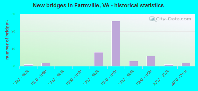
- New bridges - historical statistics
- 11920-1929
- 21930-1939
- 81960-1969
- 261970-1979
- 31980-1989
- 61990-1999
- 12000-2009
- 22010-2019


- Bridge Condition - Deck
- 50.0%Good
- 40.0%Satisfactory
- 10.0%Fair

- Bridge Condition - Superstructure
- 6.7%Very good
- 36.7%Good
- 40.0%Satisfactory
- 16.7%Fair

- Bridge Condition - Substructure
- 3.3%Very good
- 50.0%Good
- 36.7%Satisfactory
- 10.0%Fair

- Bridge Condition - Channel
- 10.7%Very good
- 28.6%Good
- 53.6%Satisfactory
- 7.1%Fair

- Bridge Condition - Culverts
- 60.0%Good
- 40.0%Satisfactory
Find on map >> Show street view
Structure Number: 4008, Location: 0.20-Rt.683/ 0.00-P.E. Co (Lat: 37.340406, Lng: -78.471397), Route carried "on" structure: US 15, Year Built: 1990, Status: Open, Structure Length: 4.94m (16.21ft), Average Daily Traffic: 4,700 (year 2020), Truck Traffic: 7%, Average Future Daily Traffic: 5,280 (year 2040), Features Intersected: Appomattox River
Minimum Vertical Clearance: 30+ m (98+ ft), Kilometerpoint: 106.097, Lanes on structure: 2, Base Highway Network: Yes, Owner: State Highway Agency, Approaching Roadway Width: 7.6m (24.9ft), Material/Design: Steel, Design/Construction: Stringer/Multi-beam, Number Of Spans In Main Unit: 3, Length of Maximum Span: 24.4m (80.1ft), Curb-To-Curb Width: 13.0m (42.7ft), Out-to-Out Width: 14.0m (45.9ft)
Condition: Deck: Satisfactory, Superstructure: Good, Substructure: Good, Channel: Very good, Operating Rating: 65.3 metric tons, Method Used To Determine Operating Rating: Load and Resistance Factor (LRFR), Inventory Rating: 50.8 metric tons, Method Used To Determine Inventory Rating: Load and Resistance Factor (LRFR), Structural Evaluation: Better than present minimum criteria, Deck Geometry: Equal to present minimum criteria, Waterway Adequacy: Equal to present desirable criteria, Approach Roadway Alignment: Equal to present desirable criteria, Designated Inspection Frequency: Every 24 months, Inspection Date: January 2022, Deck Structure Type: Concrete Cast-file-Place, Wearing Surface/Protective System: Deck Protection: Epoxy Coated Reinforcing
Find on map >> Show street view
Structure Number: 5726, Location: 1.30 to 657 - 0.80 to 702 (Lat: 37.317619, Lng: -78.352972), Route carried "on" structure: County highway 600, Year Built: 1990, Status: Open, Structure Length: 0.88m (2.89ft), Average Daily Traffic: 860 (year 2020), Truck Traffic: 2%, Average Future Daily Traffic: 946 (year 2040), Features Intersected: Bad Luck Branch, Facility Carried by Structure: River Road
Minimum Vertical Clearance: 30+ m (98+ ft), Kilometerpoint: 30.836, Lanes on structure: 2, Owner: State Highway Agency, Approaching Roadway Width: 6.7m (22.0ft), Material/Design: Steel, Design/Construction: Culvert, Number Of Spans In Main Unit: 2, Length of Maximum Span: 3.6m (11.8ft)
Condition: Channel: Fair, Culverts: Satisfactory, Operating Rating: 49.9 metric tons, Method Used To Determine Operating Rating: Field evaluation and documented engineering judgment, Inventory Rating: 29.9 metric tons, Method Used To Determine Inventory Rating: Field evaluation and documented engineering judgment, Structural Evaluation: Equal to present minimum criteria, Waterway Adequacy: Equal to present desirable criteria, Approach Roadway Alignment: Equal to present desirable criteria, Designated Inspection Frequency: Every 24 months, Inspection Date: May 2021
Find on map >> Show street view
Structure Number: 5755, Location: 0.20 to 668 - 0.50 to 637 (Lat: 37.345661, Lng: -78.411261), Route carried "on" structure: County highway 635, Year Built: 1994, Status: Open, Structure Length: 0.85m (2.79ft), Average Daily Traffic: 153 (year 2017), Average Future Daily Traffic: 171 (year 2040), Design Load: HS 20, Features Intersected: Dry Creek, Facility Carried by Structure: Pleasant Valley Rd
Minimum Vertical Clearance: 30+ m (98+ ft), Kilometerpoint: 0.805, Lanes on structure: 2, Owner: State Highway Agency, Approaching Roadway Width: 5.5m (18.0ft), Material/Design: Concrete, Design/Construction: Culvert, Number Of Spans In Main Unit: 3, Length of Maximum Span: 2.7m (8.9ft)
Condition: Channel: Satisfactory, Culverts: Good, Operating Rating: 54.4 metric tons, Method Used To Determine Operating Rating: Load Factor (LF), Inventory Rating: 32.7 metric tons, Method Used To Determine Inventory Rating: Load Factor (LF), Structural Evaluation: Better than present minimum criteria, Waterway Adequacy: Equal to present desirable criteria, Approach Roadway Alignment: Equal to present desirable criteria, Designated Inspection Frequency: Every 24 months, Inspection Date: January 2021
Find on map >> Show street view
Structure Number: 7805, Location: 0.87 RT 755; 1.52 RT 827 (Lat: 36.930481, Lng: -79.872778), Route carried "on" structure: US 220, Year Built: 1967, Status: Open, Structure Length: 0.76m (2.49ft), Average Daily Traffic: 7,211 (year 2020), Truck Traffic: 13%, Average Future Daily Traffic: 10,095 (year 2040), Design Load: HS 20, Features Intersected: N Fork Chestnut Creek
Minimum Vertical Clearance: 30+ m (98+ ft), Kilometerpoint: 54.873, Lanes on structure: 2, Base Highway Network: Yes, Owner: State Highway Agency, Approaching Roadway Width: 7.3m (24.0ft), Material/Design: Concrete, Design/Construction: Culvert, Number Of Spans In Main Unit: 3, Length of Maximum Span: 2.4m (7.9ft)
Condition: Channel: Satisfactory, Culverts: Satisfactory, Operating Rating: 54.4 metric tons, Method Used To Determine Operating Rating: Field evaluation and documented engineering judgment, Inventory Rating: 32.7 metric tons, Method Used To Determine Inventory Rating: Field evaluation and documented engineering judgment, Structural Evaluation: Equal to present minimum criteria, Waterway Adequacy: Equal to present desirable criteria, Approach Roadway Alignment: Equal to present desirable criteria, Designated Inspection Frequency: Every 24 months, Inspection Date: October 2020
Find on map >> Show street view
Structure Number: 7806, Location: 0.02 RT 756; 0.89 RT 724 (Lat: 36.904300, Lng: -79.866400), Route carried "on" structure: US 220, Year Built: 1967, Status: Open, Structure Length: 0.82m (2.69ft), Average Daily Traffic: 7,211 (year 2020), Truck Traffic: 13%, Average Future Daily Traffic: 10,095 (year 2040), Design Load: HS 20, Features Intersected: S Fork Chestnut Crk
Minimum Vertical Clearance: 30+ m (98+ ft), Kilometerpoint: 51.673, Lanes on structure: 2, Base Highway Network: Yes, Owner: State Highway Agency, Approaching Roadway Width: 7.3m (24.0ft), Skew: 2 degrees, Material/Design: Concrete, Design/Construction: Culvert, Number Of Spans In Main Unit: 3, Length of Maximum Span: 2.4m (7.9ft)
Condition: Channel: Satisfactory, Culverts: Satisfactory, Operating Rating: 54.4 metric tons, Method Used To Determine Operating Rating: Field evaluation and documented engineering judgment, Inventory Rating: 32.7 metric tons, Method Used To Determine Inventory Rating: Field evaluation and documented engineering judgment, Structural Evaluation: Equal to present minimum criteria, Waterway Adequacy: Better than present minimum criteria, Approach Roadway Alignment: Equal to present desirable criteria, Designated Inspection Frequency: Every 24 months, Inspection Date: October 2020
Find on map >> Show street view
Structure Number: 7897, Location: 0.20 RT 1612; 0.70 RT 692 (Lat: 37.115986, Lng: -79.937369), Route carried "on" structure: County highway 684, Year Built: 1982, Status: Open, Structure Length: 2.47m (8.10ft), Average Daily Traffic: 1,168 (year 2020), Truck Traffic: 3%, Average Future Daily Traffic: 1,635 (year 2040), Design Load: HS 20+Mod, Features Intersected: Maggodee Creek
Minimum Vertical Clearance: 30+ m (98+ ft), Kilometerpoint: 1.561, Lanes on structure: 2, Owner: State Highway Agency, Approaching Roadway Width: 6.7m (22.0ft), Skew: 6 degrees, Material/Design: Concrete, Design/Construction: Culvert, Number Of Spans In Main Unit: 3, Length of Maximum Span: 3.0m (9.8ft)
Condition: Channel: Satisfactory, Culverts: Good, Operating Rating: 29.0 metric tons, Method Used To Determine Operating Rating: Load Factor (LF), Inventory Rating: 17.2 metric tons, Method Used To Determine Inventory Rating: Load Factor (LF), Structural Evaluation: Meets minimum limits, Waterway Adequacy: Equal to present minimum criteria, Approach Roadway Alignment: Equal to present desirable criteria, Designated Inspection Frequency: Every 24 months, Inspection Date: June 2021
Find on map >> Show street view
Structure Number: 79, Location: 0.10 RT 691; 0.90 RT 697 (Lat: 37.093436, Lng: -79.856322), Route carried "on" structure: County highway 687, Year Built: 1932, Status: Open, Structure Length: 1.17m (3.84ft), Average Daily Traffic: 72 (year 2014), Average Future Daily Traffic: 81 (year 2040), Features Intersected: Mollie Branch
Minimum Vertical Clearance: 30+ m (98+ ft), Kilometerpoint: 2.595, Lanes on structure: 2, Owner: State Highway Agency, Approaching Roadway Width: 5.5m (18.0ft), Material/Design: Steel, Design/Construction: Stringer/Multi-beam, Number Of Spans In Main Unit: 1, Length of Maximum Span: 11.0m (36.1ft), Curb-To-Curb Width: 7.3m (24.0ft), Out-to-Out Width: 8.0m (26.2ft)
Condition: Deck: Good, Superstructure: Very good, Substructure: Satisfactory, Channel: Satisfactory, Operating Rating: 47.2 metric tons, Method Used To Determine Operating Rating: Load Factor (LF), Inventory Rating: 28.1 metric tons, Method Used To Determine Inventory Rating: Load Factor (LF), Structural Evaluation: Equal to present minimum criteria, Deck Geometry: Equal to present minimum criteria, Waterway Adequacy: Equal to present minimum criteria, Approach Roadway Alignment: High priority of corrective action, Designated Inspection Frequency: Every 24 months, Inspection Date: March 2022, Deck Structure Type: Wood or Timber, Wearing Surface/Protective System: Wearing Surface: Bituminous
Find on map >> Show street view
Structure Number: 7902, Location: 0.70 RT 678; 1.50 RT 972 (Lat: 37.134197, Lng: -79.815253), Route carried "on" structure: County highway 688, Year Built: 1974, Status: Posted for load, Structure Length: 1.58m (5.18ft), Average Daily Traffic: 707 (year 2014), Average Future Daily Traffic: 1,075 (year 2040), Features Intersected: Gills Creek
Minimum Vertical Clearance: 30+ m (98+ ft), Kilometerpoint: 5.503, Lanes on structure: 2, Owner: State Highway Agency, Approaching Roadway Width: 6.7m (22.0ft), Skew: 2 degrees, Material/Design: Steel, Design/Construction: Stringer/Multi-beam, Number Of Spans In Main Unit: 1, Length of Maximum Span: 15.8m (51.8ft), Curb or Sidewalk Widths: Left: 0.2m (0.7ft), Right: 0.2m (0.7ft), Curb-To-Curb Width: 7.0m (23.0ft), Out-to-Out Width: 7.6m (24.9ft)
Condition: Deck: Fair, Superstructure: Fair, Substructure: Fair, Channel: Satisfactory, Operating Rating: 23.6 metric tons, Method Used To Determine Operating Rating: Load Factor (LF), Inventory Rating: 13.6 metric tons, Method Used To Determine Inventory Rating: Load Factor (LF), Structural Evaluation: Meets minimum limits, Deck Geometry: Meets minimum limits, Waterway Adequacy: Equal to present minimum criteria, Approach Roadway Alignment: High priority of corrective action, Bridge Posting: Required (Relationship of Operating Rating to Maximum Legal Load: > 39.9% below), Length Of Structure Improvement: 1.58m (5.18ft), Designated Inspection Frequency: Every 12 months, Inspection Date: November 2021, Bridge Improvement Cost: $829,000, Roadway Improvement Cost: $207,000, Total Project Cost: $2,654,000 ( Estimate for 2021), Deck Structure Type: Wood or Timber, Wearing Surface/Protective System: Wearing Surface: Bituminous
Find on map >> Show street view
Structure Number: 8124, Location: 0.30 T0 11 - 3.31 TO 672 (Lat: 39.220672, Lng: -78.138608), Route carried "on" structure: Interstate 81, Year Built: 1964, Status: Open, Structure Length: 5.82m (19.09ft), Average Daily Traffic: 22,991 (year 2010), Truck Traffic: 25%, Average Future Daily Traffic: 36,786 (year 2040), Design Load: HS 20+Mod, Features Intersected: W & W RAILWAY
Minimum Vertical Clearance: 30+ m (98+ ft), Kilometerpoint: 513.094, Lanes on structure: 3, Base Highway Network: Yes, Owner: State Highway Agency, Approaching Roadway Width: 11.3m (37.1ft), Skew: 4 degrees, Material/Design: Steel, Design/Construction: Stringer/Multi-beam, Number Of Spans In Main Unit: 3, Length of Maximum Span: 19.8m (65.0ft), Curb-To-Curb Width: 15.2m (49.9ft), Out-to-Out Width: 15.8m (51.8ft)
Condition: Deck: Fair, Superstructure: Satisfactory, Substructure: Fair, Operating Rating: 82.6 metric tons, Method Used To Determine Operating Rating: Load and Resistance Factor (LRFR), Inventory Rating: 63.5 metric tons, Method Used To Determine Inventory Rating: Load and Resistance Factor (LRFR), Structural Evaluation: Somewhat better than minimum adequacy, Deck Geometry: Meets minimum limits, Underclear: Meets minimum limits, Approach Roadway Alignment: Better than present minimum criteria, Length Of Structure Improvement: 5.82m (19.09ft), Designated Inspection Frequency: Every 24 months, Inspection Date: December 2020, Bridge Improvement Cost: $745,000, Roadway Improvement Cost: $5,000, Total Project Cost: $751,000, Deck Structure Type: Concrete Cast-file-Place, Wearing Surface/Protective System: Wearing Surface: Latex Concrete
Find on map >> Show street view
Structure Number: 8126, Location: 4.47 TO 627 - 0.36 TO 277 (Lat: 39.077956, Lng: -78.220042), Route carried "on" structure: Interstate 81, Year Built: 1965, Status: Open, Structure Length: 0.79m (2.59ft), Average Daily Traffic: 47,081 (year 2020), Truck Traffic: 21%, Average Future Daily Traffic: 65,913 (year 2040), Design Load: HS 20, Features Intersected: STEPHENS RUN
Minimum Vertical Clearance: 30+ m (98+ ft), Kilometerpoint: 494.784, Lanes on structure: 4, Base Highway Network: Yes, Owner: State Highway Agency, Approaching Roadway Width: 22.6m (74.1ft), Skew: 10 degrees, Material/Design: Concrete, Design/Construction: Culvert, Number Of Spans In Main Unit: 3, Length of Maximum Span: 2.4m (7.9ft)
Condition: Channel: Good, Culverts: Good, Operating Rating: 44.5 metric tons, Method Used To Determine Operating Rating: Field evaluation and documented engineering judgment, Inventory Rating: 32.7 metric tons, Method Used To Determine Inventory Rating: Field evaluation and documented engineering judgment, Structural Evaluation: Better than present minimum criteria, Waterway Adequacy: Equal to present minimum criteria, Approach Roadway Alignment: Equal to present desirable criteria, Designated Inspection Frequency: Every 24 months, Inspection Date: April 2021
Find on map >> Show street view
Structure Number: 8163, Location: 0.47 TO 771 - 0.18 TO 127 (Lat: 39.337911, Lng: -78.307219), Route carried "on" structure: US 522, Year Built: 1989, Status: Open, Structure Length: 1.34m (4.40ft), Average Daily Traffic: 6,955 (year 2020), Truck Traffic: 16%, Average Future Daily Traffic: 9,738 (year 2040), Design Load: HS 20+Mod, Features Intersected: LITTLE ISSAC CREEK, Facility Carried by Structure: N FREDERICK PK-NBL
Minimum Vertical Clearance: 30+ m (98+ ft), Kilometerpoint: 256.446, Lanes on structure: 2, Base Highway Network: Yes, Owner: State Highway Agency, Approaching Roadway Width: 10.1m (33.1ft), Skew: 3 degrees, Material/Design: Concrete, Design/Construction: Culvert, Number Of Spans In Main Unit: 4, Length of Maximum Span: 2.7m (8.9ft)
Condition: Channel: Satisfactory, Culverts: Good, Operating Rating: 54.4 metric tons, Method Used To Determine Operating Rating: Field evaluation and documented engineering judgment, Inventory Rating: 32.7 metric tons, Method Used To Determine Inventory Rating: Field evaluation and documented engineering judgment, Structural Evaluation: Better than present minimum criteria, Waterway Adequacy: Equal to present minimum criteria, Approach Roadway Alignment: Better than present minimum criteria, Designated Inspection Frequency: Every 24 months, Inspection Date: October 2021
Find on map >> Show street view
Structure Number: 8168, Location: 1.10 TO 608 - 0.10 TO 681 (Lat: 39.267597, Lng: -78.240142), Route carried "on" structure: US 522, Year Built: 1966, Status: Open, Structure Length: 5.18m (16.99ft), Average Daily Traffic: 7,902 (year 2020), Truck Traffic: 16%, Average Future Daily Traffic: 11,063 (year 2040), Design Load: HS 20+Mod, Features Intersected: HOGUE CREEK, Facility Carried by Structure: N FREDERICK PK-SBL
Minimum Vertical Clearance: 30+ m (98+ ft), Kilometerpoint: 233.672, Lanes on structure: 2, Base Highway Network: Yes, Owner: State Highway Agency, Approaching Roadway Width: 7.9m (25.9ft), Material/Design: Concrete, Design/Construction: Tee Beam, Number Of Spans In Main Unit: 4, Length of Maximum Span: 13.1m (43.0ft), Curb or Sidewalk Widths: Left: 0.2m (0.7ft), Right: 0.2m (0.7ft), Curb-To-Curb Width: 11.8m (38.7ft), Out-to-Out Width: 12.7m (41.7ft)
Condition: Deck: Satisfactory, Superstructure: Good, Substructure: Fair, Channel: Very good, Operating Rating: 46.3 metric tons, Method Used To Determine Operating Rating: Load and Resistance Factor (LRFR), Inventory Rating: 35.4 metric tons, Method Used To Determine Inventory Rating: Load and Resistance Factor (LRFR), Structural Evaluation: Somewhat better than minimum adequacy, Deck Geometry: Better than present minimum criteria, Waterway Adequacy: Equal to present minimum criteria, Approach Roadway Alignment: Better than present minimum criteria, Designated Inspection Frequency: Every 24 months, Inspection Date: October 2020, Bridge Improvement Cost: $183,000, Roadway Improvement Cost: $18,000, Total Project Cost: $202,000, Deck Structure Type: Concrete Cast-file-Place, Wearing Surface/Protective System: Wearing Surface: Epoxy Overlay
Find on map >> Show street view
Structure Number: 13559, Location: 1.60 to 40 - 0.60 to 782 (Lat: 36.947683, Lng: -79.600919), Route carried "on" structure: County highway 635, Year Built: 1967, Status: Posted for load, Structure Length: 1.29m (4.23ft), Average Daily Traffic: 145 (year 2015), Average Future Daily Traffic: 190 (year 2040), Features Intersected: Jonnikin Creek, Facility Carried by Structure: Armstrong Road
Minimum Vertical Clearance: 30+ m (98+ ft), Kilometerpoint: 0.966, Lanes on structure: 2, Owner: State Highway Agency, Approaching Roadway Width: 6.1m (20.0ft), Skew: 3 degrees, Material/Design: Steel, Design/Construction: Stringer/Multi-beam, Number Of Spans In Main Unit: 1, Length of Maximum Span: 11.3m (37.1ft), Curb or Sidewalk Widths: Left: 0.2m (0.7ft), Right: 0.2m (0.7ft), Curb-To-Curb Width: 5.8m (19.0ft), Out-to-Out Width: 6.7m (22.0ft)
Condition: Deck: Satisfactory, Superstructure: Fair, Substructure: Good, Channel: Good, Operating Rating: 20.9 metric tons, Method Used To Determine Operating Rating: Load Factor (LF), Inventory Rating: 11.8 metric tons, Method Used To Determine Inventory Rating: Load Factor (LF), Structural Evaluation: Meets minimum limits, Deck Geometry: High priority of corrective action, Waterway Adequacy: Better than present minimum criteria, Approach Roadway Alignment: Equal to present desirable criteria, Length Of Structure Improvement: 1.92m (6.30ft), Designated Inspection Frequency: Every 12 months, Inspection Date: September 2021, Bridge Improvement Cost: $335,000, Roadway Improvement Cost: $34,000, Total Project Cost: $503,000 ( Estimate for 2015), Deck Structure Type: Wood or Timber, Wearing Surface/Protective System: Wearing Surface: Bituminous
Find on map >> Show street view
Structure Number: 13876, Location: 0.96N-Rt 15/3.70S-Rt 15 (Lat: 37.305781, Lng: -78.447389), Route carried "on" structure: Bypass US 15, Year Built: 1976, Status: Open, Structure Length: 3.84m (12.60ft), Average Daily Traffic: 4,516 (year 2020), Truck Traffic: 11%, Average Future Daily Traffic: 6,322 (year 2040), Features Intersected: Pedestrian Trail
Minimum Vertical Clearance: 30+ m (98+ ft), Kilometerpoint: 101.330, Lanes on structure: 2, Base Highway Network: Yes, Owner: State Highway Agency, Approaching Roadway Width: 7.9m (25.9ft), Skew: 1 degrees, Material/Design: Steel, Design/Construction: Stringer/Multi-beam, Number Of Spans In Main Unit: 3, Length of Maximum Span: 12.8m (42.0ft), Curb or Sidewalk Widths: Left: 0.3m (1.0ft), Right: 0.3m (1.0ft), Curb-To-Curb Width: 12.2m (40.0ft), Out-to-Out Width: 13.4m (44.0ft)
Condition: Deck: Satisfactory, Superstructure: Good, Substructure: Satisfactory, Operating Rating: 69.9 metric tons, Method Used To Determine Operating Rating: Load and Resistance Factor (LRFR), Inventory Rating: 53.5 metric tons, Method Used To Determine Inventory Rating: Load and Resistance Factor (LRFR), Structural Evaluation: Equal to present minimum criteria, Deck Geometry: Better than present minimum criteria, Approach Roadway Alignment: Equal to present desirable criteria, Designated Inspection Frequency: Every 24 months, Inspection Date: March 2021, Deck Structure Type: Concrete Cast-file-Place
Find on map >> Show street view
Structure Number: 13878, Location: 0.83 CL Farm/0.05 Rt 628 (Lat: 37.269008, Lng: -78.405694), Route carried "on" structure: US 15, Year Built: 1976, Status: Open, Structure Length: 8.21m (26.94ft), Average Daily Traffic: 11,000 (year 2020), Truck Traffic: 12%, Average Future Daily Traffic: 12,000 (year 2035), Design Load: HS 20+Mod, Features Intersected: Rte 460 Bypass
Minimum Vertical Clearance: 30+ m (98+ ft), Kilometerpoint: 95.446, Lanes on structure: 2, Lanes under structure: 4, Base Highway Network: Yes, Owner: State Highway Agency, Approaching Roadway Width: 9.1m (29.9ft), Skew: 2 degrees, Material/Design: Steel continuous, Design/Construction: Stringer/Multi-beam, Number Of Spans In Main Unit: 2, Length of Maximum Span: 40.8m (133.9ft), Curb-To-Curb Width: 11.6m (38.1ft), Out-to-Out Width: 12.8m (42.0ft)
Condition: Deck: Good, Superstructure: Satisfactory, Substructure: Satisfactory, Operating Rating: 75.3 metric tons, Method Used To Determine Operating Rating: Load and Resistance Factor (LRFR), Inventory Rating: 58.1 metric tons, Method Used To Determine Inventory Rating: Load and Resistance Factor (LRFR), Structural Evaluation: Equal to present minimum criteria, Deck Geometry: Better than present minimum criteria, Underclear: Equal to present minimum criteria, Approach Roadway Alignment: Equal to present minimum criteria, Designated Inspection Frequency: Every 24 months, Inspection Date: May 2021, Deck Structure Type: Concrete Cast-file-Place, Wearing Surface/Protective System: Wearing Surface: Epoxy Overlay
Find on map >> Show street view
Structure Number: 1388, Location: .83-Farmville/.05 Rt 628 (Lat: 37.268986, Lng: -78.405450), Route carried "on" structure: US 15, Year Built: 1976, Status: Open, Structure Length: 8.20m (26.90ft), Average Daily Traffic: 5,359 (year 2018), Truck Traffic: 3%, Average Future Daily Traffic: 9,455 (year 2035), Design Load: HS 20+Mod, Features Intersected: Route 460 Bypass
Minimum Vertical Clearance: 30+ m (98+ ft), Kilometerpoint: 95.446, Lanes on structure: 2, Lanes under structure: 4, Base Highway Network: Yes, Owner: State Highway Agency, Approaching Roadway Width: 9.1m (29.9ft), Skew: 2 degrees, Material/Design: Steel continuous, Design/Construction: Stringer/Multi-beam, Number Of Spans In Main Unit: 2, Length of Maximum Span: 41.1m (134.8ft), Curb-To-Curb Width: 11.6m (38.1ft), Out-to-Out Width: 12.8m (42.0ft)
Condition: Deck: Good, Superstructure: Satisfactory, Substructure: Satisfactory, Operating Rating: 75.3 metric tons, Method Used To Determine Operating Rating: Load and Resistance Factor (LRFR), Inventory Rating: 58.1 metric tons, Method Used To Determine Inventory Rating: Load and Resistance Factor (LRFR), Structural Evaluation: Equal to present minimum criteria, Deck Geometry: Better than present minimum criteria, Underclear: Equal to present minimum criteria, Approach Roadway Alignment: Equal to present minimum criteria, Designated Inspection Frequency: Every 24 months, Inspection Date: May 2021, Deck Structure Type: Concrete Cast-file-Place, Wearing Surface/Protective System: Wearing Surface: Epoxy Overlay
Find on map >> Show street view
Structure Number: 13882, Location: 1.76-Rt 15N/2.98-Rt 15S (Lat: 37.295028, Lng: -78.440333), Route carried "on" structure: Bypass US 15, Year Built: 1976, Status: Open, Structure Length: 11.02m (36.15ft), Average Daily Traffic: 4,516 (year 2020), Truck Traffic: 11%, Average Future Daily Traffic: 6,322 (year 2040), Design Load: HS 20+Mod, Features Intersected: Buffalo Creek
Minimum Vertical Clearance: 30+ m (98+ ft), Kilometerpoint: 100.035, Lanes on structure: 2, Base Highway Network: Yes, Owner: State Highway Agency, Approaching Roadway Width: 8.2m (26.9ft), Material/Design: Steel continuous, Design/Construction: Stringer/Multi-beam, Number Of Spans In Main Unit: 3, Length of Maximum Span: 41.7m (136.8ft), Curb-To-Curb Width: 12.2m (40.0ft), Out-to-Out Width: 13.4m (44.0ft)
Condition: Deck: Good, Superstructure: Satisfactory, Substructure: Good, Channel: Good, Operating Rating: 68.0 metric tons, Method Used To Determine Operating Rating: Load and Resistance Factor (LRFR), Inventory Rating: 52.6 metric tons, Method Used To Determine Inventory Rating: Load and Resistance Factor (LRFR), Structural Evaluation: Equal to present minimum criteria, Deck Geometry: Better than present minimum criteria, Waterway Adequacy: Equal to present desirable criteria, Approach Roadway Alignment: Better than present minimum criteria, Designated Inspection Frequency: Every 24 months, Inspection Date: April 2021, Deck Structure Type: Concrete Cast-file-Place, Wearing Surface/Protective System: Wearing Surface: Latex Concrete
Find on map >> Show street view
Structure Number: 13884, Location: 0.96-Rt 15N/ 3.70-Rt 15S (Lat: 37.306006, Lng: -78.446808), Route carried "on" structure: Bypass US 15, Year Built: 1976, Status: Open, Structure Length: 3.92m (12.86ft), Average Daily Traffic: 4,516 (year 2020), Truck Traffic: 11%, Average Future Daily Traffic: 6,322 (year 2040), Design Load: HS 20+Mod, Features Intersected: Pedestrian trail
Minimum Vertical Clearance: 30+ m (98+ ft), Kilometerpoint: 101.330, Lanes on structure: 2, Base Highway Network: Yes, Owner: State Highway Agency, Approaching Roadway Width: 7.9m (25.9ft), Skew: 1 degrees, Material/Design: Steel, Design/Construction: Stringer/Multi-beam, Number Of Spans In Main Unit: 3, Length of Maximum Span: 12.8m (42.0ft), Curb-To-Curb Width: 12.2m (40.0ft), Out-to-Out Width: 13.4m (44.0ft)
Condition: Deck: Fair, Superstructure: Good, Substructure: Satisfactory, Operating Rating: 71.2 metric tons, Method Used To Determine Operating Rating: Load and Resistance Factor (LRFR), Inventory Rating: 55.0 metric tons, Method Used To Determine Inventory Rating: Load and Resistance Factor (LRFR), Structural Evaluation: Equal to present minimum criteria, Deck Geometry: Better than present minimum criteria, Approach Roadway Alignment: Equal to present desirable criteria, Designated Inspection Frequency: Every 24 months, Inspection Date: March 2021, Deck Structure Type: Concrete Cast-file-Place
Find on map >> Show street view
Structure Number: 13885, Location: 0.24N-Rt 15/ 0.40-Rt 460B (Lat: 37.312381, Lng: -78.461031), Route carried "on" structure: Bypass US 15, Year Built: 1976, Status: Open, Structure Length: 7.45m (24.44ft), Average Daily Traffic: 3,600 (year 2020), Truck Traffic: 9%, Average Future Daily Traffic: 5,400 (year 2040), Design Load: HS 20+Mod, Features Intersected: 460 Bypass
Minimum Vertical Clearance: 30+ m (98+ ft), Kilometerpoint: 102.838, Lanes on structure: 2, Lanes under structure: 5, Base Highway Network: Yes, Owner: State Highway Agency, Approaching Roadway Width: 5.5m (18.0ft), Material/Design: Steel continuous, Design/Construction: Stringer/Multi-beam, Number Of Spans In Main Unit: 2, Length of Maximum Span: 36.3m (119.1ft), Curb-To-Curb Width: 9.1m (29.9ft), Out-to-Out Width: 10.4m (34.1ft)
Condition: Deck: Good, Superstructure: Satisfactory, Substructure: Good, Operating Rating: 69.9 metric tons, Method Used To Determine Operating Rating: Load and Resistance Factor (LRFR), Inventory Rating: 54.4 metric tons, Method Used To Determine Inventory Rating: Load and Resistance Factor (LRFR), Structural Evaluation: Equal to present minimum criteria, Deck Geometry: Meets minimum limits, Underclear: Better than present minimum criteria, Approach Roadway Alignment: Equal to present desirable criteria, Designated Inspection Frequency: Every 24 months, Inspection Date: October 2021, Deck Structure Type: Concrete Cast-file-Place, Wearing Surface/Protective System: Wearing Surface: Latex Concrete
Find on map >> Show street view
Structure Number: 13887, Location: 0.24-Rt 15Bus/0.36-Rt460B (Lat: 37.312481, Lng: -78.461211), Route carried "on" structure: Bypass US 15, Year Built: 1976, Status: Open, Structure Length: 7.45m (24.44ft), Average Daily Traffic: 1,439 (year 2020), Truck Traffic: 11%, Average Future Daily Traffic: 1,583 (year 2040), Design Load: HS 20+Mod, Features Intersected: Route 460 Bypass
Minimum Vertical Clearance: 30+ m (98+ ft), Kilometerpoint: 102.838, Lanes on structure: 2, Lanes under structure: 5, Base Highway Network: Yes, Owner: State Highway Agency, Approaching Roadway Width: 5.5m (18.0ft), Material/Design: Steel continuous, Design/Construction: Stringer/Multi-beam, Number Of Spans In Main Unit: 2, Length of Maximum Span: 36.3m (119.1ft), Curb-To-Curb Width: 9.1m (29.9ft), Out-to-Out Width: 10.4m (34.1ft)
Condition: Deck: Satisfactory, Superstructure: Satisfactory, Substructure: Good, Operating Rating: 69.9 metric tons, Method Used To Determine Operating Rating: Load and Resistance Factor (LRFR), Inventory Rating: 54.4 metric tons, Method Used To Determine Inventory Rating: Load and Resistance Factor (LRFR), Structural Evaluation: Equal to present minimum criteria, Deck Geometry: Meets minimum limits, Underclear: Better than present minimum criteria, Approach Roadway Alignment: Better than present minimum criteria, Designated Inspection Frequency: Every 24 months, Inspection Date: October 2021, Deck Structure Type: Concrete Cast-file-Place, Wearing Surface/Protective System: Wearing Surface: Latex Concrete
Find on map >> Show street view
Structure Number: 13889, Location: 0.88 to 15S/4.30 to 15N (Lat: 37.274328, Lng: -78.419936), Route carried "on" structure: US 15, Year Built: 1976, Status: Open, Structure Length: 0.88m (2.89ft), Average Daily Traffic: 4,516 (year 2020), Truck Traffic: 11%, Average Future Daily Traffic: 6,322 (year 2040), Features Intersected: Little Buffalo Creek
Minimum Vertical Clearance: 30+ m (98+ ft), Kilometerpoint: 96.999, Lanes on structure: 2, Base Highway Network: Yes, Owner: State Highway Agency, Approaching Roadway Width: 8.2m (26.9ft), Skew: 2 degrees, Material/Design: Concrete, Design/Construction: Culvert, Number Of Spans In Main Unit: 3, Length of Maximum Span: 2.7m (8.9ft)
Condition: Channel: Satisfactory, Culverts: Good, Operating Rating: 89.8 metric tons, Method Used To Determine Operating Rating: Load Factor (LF), Inventory Rating: 89.8 metric tons, Method Used To Determine Inventory Rating: Load Factor (LF), Structural Evaluation: Better than present minimum criteria, Waterway Adequacy: Better than present minimum criteria, Approach Roadway Alignment: Equal to present desirable criteria, Designated Inspection Frequency: Every 24 months, Inspection Date: June 2021
Find on map >> Show street view
Structure Number: 1389, Location: 0.88 to 15S / 4.30 to 15N (Lat: 37.275031, Lng: -78.419489), Route carried "on" structure: US 15, Year Built: 1976, Status: Open, Structure Length: 0.85m (2.79ft), Average Daily Traffic: 4,516 (year 2020), Truck Traffic: 11%, Average Future Daily Traffic: 6,322 (year 2040), Design Load: HS 20, Features Intersected: Little Buffalo Creek
Minimum Vertical Clearance: 30+ m (98+ ft), Kilometerpoint: 96.999, Lanes on structure: 2, Base Highway Network: Yes, Owner: State Highway Agency, Approaching Roadway Width: 8.2m (26.9ft), Skew: 2 degrees, Material/Design: Concrete, Design/Construction: Culvert, Number Of Spans In Main Unit: 3, Length of Maximum Span: 2.7m (8.9ft)
Condition: Channel: Fair, Culverts: Good, Operating Rating: 89.8 metric tons, Method Used To Determine Operating Rating: Load Factor (LF), Inventory Rating: 89.8 metric tons, Method Used To Determine Inventory Rating: Load Factor (LF), Structural Evaluation: Better than present minimum criteria, Waterway Adequacy: Better than present minimum criteria, Approach Roadway Alignment: Equal to present desirable criteria, Designated Inspection Frequency: Every 24 months, Inspection Date: June 2021
Find on map >> Show street view
Structure Number: 13907, Location: 0.86-ECL Farm/ 0.25-Rt460 (Lat: 37.280611, Lng: -78.363353), Route carried "on" structure: Business US 460, Year Built: 1928, Status: Open, Structure Length: 3.35m (10.99ft), Average Daily Traffic: 7,245 (year 2020), Truck Traffic: 2%, Average Future Daily Traffic: 7,970 (year 2040), Features Intersected: Briery Creek
Minimum Vertical Clearance: 30+ m (98+ ft), Kilometerpoint: 411.647, Lanes on structure: 2, Owner: State Highway Agency, Approaching Roadway Width: 8.5m (27.9ft), Material/Design: Concrete, Design/Construction: Tee Beam, Number Of Spans In Main Unit: 4, Length of Maximum Span: 7.6m (24.9ft), Curb or Sidewalk Widths: Left: 0.8m (2.6ft), Right: 0.8m (2.6ft), Curb-To-Curb Width: 8.5m (27.9ft), Out-to-Out Width: 10.2m (33.5ft)
Condition: Deck: Satisfactory, Superstructure: Fair, Substructure: Satisfactory, Channel: Satisfactory, Operating Rating: 51.7 metric tons, Method Used To Determine Operating Rating: Load Factor (LF), Inventory Rating: 30.8 metric tons, Method Used To Determine Inventory Rating: Load Factor (LF), Structural Evaluation: Somewhat better than minimum adequacy, Deck Geometry: High priority of replacement, Waterway Adequacy: Better than present minimum criteria, Approach Roadway Alignment: Somewhat better than minimum adequacy, Length Of Structure Improvement: 4.36m (14.30ft), Designated Inspection Frequency: Every 24 months, Inspection Date: May 2021, Bridge Improvement Cost: $1,304,000, Roadway Improvement Cost: $130,000, Total Project Cost: $1,956,000 ( Estimate for 2015), Deck Structure Type: Concrete Cast-file-Place, Wearing Surface/Protective System: Wearing Surface: Bituminous
Find on map >> Show street view
Structure Number: 13911, Location: 0.06 to 630 - 0.16 to 636 (Lat: 37.278583, Lng: -78.351222), Route carried "on" structure: US 460, Year Built: 1971, Status: Open, Structure Length: 5.70m (18.70ft), Average Daily Traffic: 6,550 (year 2020), Truck Traffic: 12%, Average Future Daily Traffic: 9,171 (year 2040), Features Intersected: Bush River
Minimum Vertical Clearance: 30+ m (98+ ft), Kilometerpoint: 412.733, Lanes on structure: 2, Base Highway Network: Yes, Owner: State Highway Agency, Approaching Roadway Width: 7.9m (25.9ft), Material/Design: Concrete, Design/Construction: Tee Beam, Number Of Spans In Main Unit: 5, Length of Maximum Span: 11.3m (37.1ft), Curb or Sidewalk Widths: Left: 0.2m (0.7ft), Right: 0.2m (0.7ft), Curb-To-Curb Width: 11.8m (38.7ft), Out-to-Out Width: 12.7m (41.7ft)
Condition: Deck: Good, Superstructure: Satisfactory, Substructure: Satisfactory, Channel: Good, Operating Rating: 53.5 metric tons, Method Used To Determine Operating Rating: Load and Resistance Factor (LRFR), Inventory Rating: 41.7 metric tons, Method Used To Determine Inventory Rating: Load and Resistance Factor (LRFR), Structural Evaluation: Equal to present minimum criteria, Deck Geometry: Better than present minimum criteria, Waterway Adequacy: Better than present minimum criteria, Approach Roadway Alignment: Equal to present desirable criteria, Designated Inspection Frequency: Every 24 months, Inspection Date: November 2020, Deck Structure Type: Concrete Cast-file-Place, Wearing Surface/Protective System: Wearing Surface: Latex Concrete
Find on map >> Show street view
Structure Number: 13914, Location: 2.78-15Bus/0.31-460Bus (Lat: 37.279050, Lng: -78.361169), Route carried "on" structure: Bypass US 460, Year Built: 1978, Status: Open, Structure Length: 6.19m (20.31ft), Average Daily Traffic: 6,550 (year 2020), Truck Traffic: 12%, Average Future Daily Traffic: 9,171 (year 2040), Features Intersected: 460 EBL Business
Minimum Vertical Clearance: 30+ m (98+ ft), Kilometerpoint: 411.778, Lanes on structure: 2, Lanes under structure: 1, Base Highway Network: Yes, Owner: State Highway Agency, Approaching Roadway Width: 11.6m (38.1ft), Skew: 4 degrees, Material/Design: Steel continuous, Design/Construction: Stringer/Multi-beam, Number Of Spans In Main Unit: 3, Length of Maximum Span: 31.4m (103.0ft), Curb-To-Curb Width: 12.2m (40.0ft), Out-to-Out Width: 13.4m (44.0ft)
Condition: Deck: Good, Superstructure: Satisfactory, Substructure: Good, Operating Rating: 61.7 metric tons, Method Used To Determine Operating Rating: Load and Resistance Factor (LRFR), Inventory Rating: 47.2 metric tons, Method Used To Determine Inventory Rating: Load and Resistance Factor (LRFR), Structural Evaluation: Equal to present minimum criteria, Deck Geometry: Better than present minimum criteria, Underclear: Better than present minimum criteria, Approach Roadway Alignment: Equal to present minimum criteria, Designated Inspection Frequency: Every 24 months, Inspection Date: November 2020, Deck Structure Type: Concrete Cast-file-Place, Wearing Surface/Protective System: Wearing Surface: Latex Concrete
Find on map >> Show street view
Structure Number: 13916, Location: 1.25-Rt15Bus/1.53-Rt460Bu (Lat: 37.268169, Lng: -78.383886), Route carried "on" structure: Bypass US 460, Year Built: 1978, Status: Open, Structure Length: 6.10m (20.01ft), Average Daily Traffic: 6,550 (year 2020), Truck Traffic: 12%, Average Future Daily Traffic: 9,171 (year 2040), Design Load: HS 20+Mod, Features Intersected: Briery Creek
Minimum Vertical Clearance: 30+ m (98+ ft), Kilometerpoint: 409.318, Lanes on structure: 2, Base Highway Network: Yes, Owner: State Highway Agency, Approaching Roadway Width: 11.6m (38.1ft), Material/Design: Steel, Design/Construction: Stringer/Multi-beam, Number Of Spans In Main Unit: 3, Length of Maximum Span: 19.5m (64.0ft), Curb-To-Curb Width: 12.2m (40.0ft), Out-to-Out Width: 13.4m (44.0ft)
Condition: Deck: Satisfactory, Superstructure: Satisfactory, Substructure: Satisfactory, Channel: Satisfactory, Operating Rating: 78.9 metric tons, Method Used To Determine Operating Rating: Load and Resistance Factor (LRFR), Inventory Rating: 60.8 metric tons, Method Used To Determine Inventory Rating: Load and Resistance Factor (LRFR), Structural Evaluation: Equal to present minimum criteria, Deck Geometry: Better than present minimum criteria, Waterway Adequacy: Equal to present desirable criteria, Approach Roadway Alignment: Better than present minimum criteria, Designated Inspection Frequency: Every 24 months, Inspection Date: April 2021, Deck Structure Type: Concrete Cast-file-Place, Wearing Surface/Protective System: Wearing Surface: Latex Concrete
Find on map >> Show street view
Structure Number: 13944, Location: 0.09-Rt 642/0.72-SCL Farm (Lat: 37.280928, Lng: -78.426814), Route carried "on" structure: County highway 628, Year Built: 1976, Status: Open, Structure Length: 7.46m (24.48ft), Average Daily Traffic: 748 (year 2020), Truck Traffic: 2%, Average Future Daily Traffic: 1,047 (year 2040), Design Load: HS 20+Mod, Features Intersected: Routes 15 & 460 Bypass, Facility Carried by Structure: Germantown Road
Minimum Vertical Clearance: 30+ m (98+ ft), Kilometerpoint: 31.005, Lanes on structure: 2, Lanes under structure: 4, Owner: State Highway Agency, Approaching Roadway Width: 6.1m (20.0ft), Skew: 1 degrees, Material/Design: Steel continuous, Design/Construction: Stringer/Multi-beam, Number Of Spans In Main Unit: 2, Length of Maximum Span: 35.7m (117.1ft), Curb-To-Curb Width: 7.9m (25.9ft), Out-to-Out Width: 9.1m (29.9ft)
Condition: Deck: Satisfactory, Superstructure: Satisfactory, Substructure: Good, Operating Rating: 79.8 metric tons, Method Used To Determine Operating Rating: Load and Resistance Factor (LRFR), Inventory Rating: 61.7 metric tons, Method Used To Determine Inventory Rating: Load and Resistance Factor (LRFR), Structural Evaluation: Equal to present minimum criteria, Deck Geometry: Somewhat better than minimum adequacy, Underclear: Better than present minimum criteria, Approach Roadway Alignment: Equal to present desirable criteria, Designated Inspection Frequency: Every 12 months, Inspection Date: Febuary 2022, Deck Structure Type: Concrete Cast-file-Place
Find on map >> Show street view
Structure Number: 13948, Location: 1.45-Rt.15 / 0.50-Rt.630 (Lat: 37.255400, Lng: -78.392653), Route carried "on" structure: County highway 628, Year Built: 1971, Status: Open, Structure Length: 3.96m (12.99ft), Average Daily Traffic: 1,112 (year 2017), Average Future Daily Traffic: 1,571 (year 2040), Features Intersected: Briery Creek, Facility Carried by Structure: Zion Hill Road
Minimum Vertical Clearance: 30+ m (98+ ft), Kilometerpoint: 25.873, Lanes on structure: 2, Owner: State Highway Agency, Approaching Roadway Width: 6.1m (20.0ft), Skew: 3 degrees, Material/Design: Steel, Design/Construction: Stringer/Multi-beam, Number Of Spans In Main Unit: 3, Length of Maximum Span: 13.4m (44.0ft), Curb or Sidewalk Widths: Left: 0.2m (0.7ft), Right: 0.2m (0.7ft), Curb-To-Curb Width: 8.1m (26.6ft), Out-to-Out Width: 9.1m (29.9ft)
Condition: Deck: Satisfactory, Superstructure: Satisfactory, Substructure: Satisfactory, Channel: Satisfactory, Operating Rating: 68.0 metric tons, Method Used To Determine Operating Rating: Load and Resistance Factor (LRFR), Inventory Rating: 52.6 metric tons, Method Used To Determine Inventory Rating: Load and Resistance Factor (LRFR), Structural Evaluation: Equal to present minimum criteria, Deck Geometry: Meets minimum limits, Waterway Adequacy: Better than present minimum criteria, Approach Roadway Alignment: Equal to present desirable criteria, Designated Inspection Frequency: Every 24 months, Inspection Date: December 2020, Deck Structure Type: Concrete Cast-file-Place, Wearing Surface/Protective System: Wearing Surface: Latex Concrete
Find on map >> Show street view
Structure Number: 13949, Location: 0.67 to 642 - 0.93 to 15 (Lat: 37.272461, Lng: -78.422008), Route carried "on" structure: County highway 628, Year Built: 1973, Year Reconstructed: 2005, Status: Open, Structure Length: 0.98m (3.22ft), Average Daily Traffic: 1,094 (year 2020), Average Future Daily Traffic: 1,532 (year 2040), Design Load: HS 20+Mod, Features Intersected: Little Buffalo Creek, Facility Carried by Structure: Commerce Road
Minimum Vertical Clearance: 30+ m (98+ ft), Kilometerpoint: 29.783, Lanes on structure: 2, Owner: State Highway Agency, Approaching Roadway Width: 6.1m (20.0ft), Skew: 4 degrees, Material/Design: Steel, Design/Construction: Stringer/Multi-beam, Number Of Spans In Main Unit: 1, Length of Maximum Span: 8.2m (26.9ft), Curb-To-Curb Width: 6.7m (22.0ft), Out-to-Out Width: 7.0m (23.0ft)
Condition: Deck: Good, Superstructure: Good, Substructure: Good, Channel: Satisfactory, Operating Rating: 49.0 metric tons, Method Used To Determine Operating Rating: Load and Resistance Factor (LRFR), Inventory Rating: 38.1 metric tons, Method Used To Determine Inventory Rating: Load and Resistance Factor (LRFR), Structural Evaluation: Better than present minimum criteria, Deck Geometry: High priority of corrective action, Waterway Adequacy: Better than present minimum criteria, Approach Roadway Alignment: Equal to present minimum criteria, Designated Inspection Frequency: Every 24 months, Inspection Date: November 2021, Deck Structure Type: Wood or Timber, Wearing Surface/Protective System: Wearing Surface: Bituminous, Membrane: Preformed Fabric
Find on map >> Show street view
Structure Number: 1397, Location: 0.54-Rt 642 / 0.11-Rt 644 (Lat: 37.286719, Lng: -78.435411), Route carried "on" structure: County highway 643, Year Built: 1976, Status: Open, Structure Length: 7.46m (24.48ft), Average Daily Traffic: 1,163 (year 2020), Truck Traffic: 3%, Average Future Daily Traffic: 1,628 (year 2040), Design Load: HS 20+Mod, Features Intersected: Rte 15 BP & 460 BP, Facility Carried by Structure: Bk Hampden-Sydney
Minimum Vertical Clearance: 30+ m (98+ ft), Kilometerpoint: 4.682, Lanes on structure: 2, Lanes under structure: 4, Owner: State Highway Agency, Approaching Roadway Width: 5.8m (19.0ft), Skew: 1 degrees, Material/Design: Steel continuous, Design/Construction: Stringer/Multi-beam, Number Of Spans In Main Unit: 2, Length of Maximum Span: 35.7m (117.1ft), Curb-To-Curb Width: 7.9m (25.9ft), Out-to-Out Width: 9.1m (29.9ft)
Condition: Deck: Good, Superstructure: Fair, Substructure: Satisfactory, Operating Rating: 76.2 metric tons, Method Used To Determine Operating Rating: Load and Resistance Factor (LRFR), Inventory Rating: 59.0 metric tons, Method Used To Determine Inventory Rating: Load and Resistance Factor (LRFR), Structural Evaluation: Somewhat better than minimum adequacy, Deck Geometry: Meets minimum limits, Underclear: Equal to present minimum criteria, Approach Roadway Alignment: Equal to present minimum criteria, Designated Inspection Frequency: Every 24 months, Inspection Date: June 2021, Deck Structure Type: Concrete Cast-file-Place
Find on map >> Show street view
Structure Number: 14005, Location: 0.47-Rt 695/1.13-Dead End (Lat: 37.302281, Lng: -78.472958), Route carried "on" structure: County highway 675, Year Built: 1981, Status: Open, Structure Length: 4.18m (13.71ft), Average Daily Traffic: 306 (year 2017), Average Future Daily Traffic: 447 (year 2040), Design Load: HS 20+Mod, Features Intersected: Pedestrian Trail, Facility Carried by Structure: Dry Bridge Road
Minimum Vertical Clearance: 30+ m (98+ ft), Kilometerpoint: 1.778, Lanes on structure: 2, Owner: State Highway Agency, Approaching Roadway Width: 5.5m (18.0ft), Skew: 1 degrees, Material/Design: Steel, Design/Construction: Stringer/Multi-beam, Number Of Spans In Main Unit: 3, Length of Maximum Span: 15.7m (51.5ft), Curb-To-Curb Width: 7.3m (24.0ft), Out-to-Out Width: 8.5m (27.9ft)
Condition: Deck: Good, Superstructure: Good, Substructure: Good, Operating Rating: 74.4 metric tons, Method Used To Determine Operating Rating: Load and Resistance Factor (LRFR), Inventory Rating: 57.2 metric tons, Method Used To Determine Inventory Rating: Load and Resistance Factor (LRFR), Structural Evaluation: Better than present minimum criteria, Deck Geometry: Somewhat better than minimum adequacy, Approach Roadway Alignment: Better than present minimum criteria, Length Of Structure Improvement: 5.18m (16.99ft), Designated Inspection Frequency: Every 24 months, Inspection Date: January 2021, Bridge Improvement Cost: $904,000, Roadway Improvement Cost: $90,000, Total Project Cost: $1,357,000 ( Estimate for 2015), Deck Structure Type: Concrete Cast-file-Place, Wearing Surface/Protective System: Wearing Surface: Monolithic Concrete, Deck Protection: Epoxy Coated Reinforcing
Find on map >> Show street view
Structure Number: 14007, Location: 0.20 to 678 / 0.11 to 768 (Lat: 37.314436, Lng: -78.466369), Route carried "on" structure: County highway 695, Year Built: 1976, Status: Open, Structure Length: 7.64m (25.07ft), Average Daily Traffic: 1,043 (year 2020), Truck Traffic: 4%, Average Future Daily Traffic: 1,147 (year 2040), Design Load: HS 20+Mod, Features Intersected: Route 460 Bypass, Facility Carried by Structure: Tuggle Road
Minimum Vertical Clearance: 30+ m (98+ ft), Kilometerpoint: 3.765, Lanes on structure: 2, Lanes under structure: 6, Owner: State Highway Agency, Approaching Roadway Width: 6.7m (22.0ft), Skew: 1 degrees, Material/Design: Steel continuous, Design/Construction: Stringer/Multi-beam, Number Of Spans In Main Unit: 2, Length of Maximum Span: 36.7m (120.4ft), Curb-To-Curb Width: 8.5m (27.9ft), Out-to-Out Width: 9.8m (32.2ft)
Condition: Deck: Good, Superstructure: Fair, Substructure: Good, Operating Rating: 68.9 metric tons, Method Used To Determine Operating Rating: Load and Resistance Factor (LRFR), Inventory Rating: 52.6 metric tons, Method Used To Determine Inventory Rating: Load and Resistance Factor (LRFR), Structural Evaluation: Somewhat better than minimum adequacy, Deck Geometry: Somewhat better than minimum adequacy, Underclear: Better than present minimum criteria, Approach Roadway Alignment: Equal to present desirable criteria, Length Of Structure Improvement: 8.41m (27.59ft), Designated Inspection Frequency: Every 24 months, Inspection Date: June 2020, Bridge Improvement Cost: $1,468,000, Roadway Improvement Cost: $147,000, Total Project Cost: $2,202,000 ( Estimate for 2014), Deck Structure Type: Concrete Cast-file-Place
Find on map >> Show street view
Structure Number: 22433, Location: 0.30 WCL Farmville (Lat: 37.297944, Lng: -78.409939), Route carried "on" structure: Business City street , Year Built: 1968, Status: Open, Structure Length: 0.98m (3.22ft), Average Daily Traffic: 1,894 (year 2020), Truck Traffic: 1%, Average Future Daily Traffic: 2,043 (year 2040), Features Intersected: Little Buffalo Creek, Facility Carried by Structure: High Street
Minimum Vertical Clearance: 30+ m (98+ ft), Kilometerpoint: 0.000, Lanes on structure: 2, Owner: Town or Township Highway Agency, Approaching Roadway Width: 9.1m (29.9ft), Material/Design: Concrete, Design/Construction: Culvert, Number Of Spans In Main Unit: 3, Length of Maximum Span: 3.0m (9.8ft)
Condition: Channel: Satisfactory, Culverts: Satisfactory, Operating Rating: 64.4 metric tons, Method Used To Determine Operating Rating: Load Factor (LF), Inventory Rating: 38.1 metric tons, Method Used To Determine Inventory Rating: Load Factor (LF), Structural Evaluation: Equal to present minimum criteria, Waterway Adequacy: Somewhat better than minimum adequacy, Approach Roadway Alignment: Somewhat better than minimum adequacy, Designated Inspection Frequency: Every 24 months, Inspection Date: July 2020
Find on map >> Show street view
Structure Number: 22435, Location: .10 S Main St/.01 Va St. (Lat: 37.300400, Lng: -78.391703), Route carried "on" structure: Business City street , Year Built: 1932, Status: Open, Structure Length: 0.76m (2.49ft), Average Daily Traffic: 1,839 (year 2020), Truck Traffic: 1%, Average Future Daily Traffic: 2,023 (year 2040), Features Intersected: Gross Creek, Facility Carried by Structure: Fourth Street
Minimum Vertical Clearance: 30+ m (98+ ft), Kilometerpoint: 0.000, Lanes on structure: 2, Owner: Town or Township Highway Agency, Approaching Roadway Width: 9.1m (29.9ft), Skew: 9 degrees, Material/Design: Concrete, Design/Construction: Slab, Number Of Spans In Main Unit: 1, Length of Maximum Span: 1.5m (4.9ft), Curb or Sidewalk Widths: Left: 1.2m (3.9ft), Right: 1.2m (3.9ft), Curb-To-Curb Width: 9.1m (29.9ft), Out-to-Out Width: 11.6m (38.1ft)
Condition: Deck: Satisfactory, Superstructure: Satisfactory, Substructure: Satisfactory, Channel: Satisfactory, Operating Rating: 54.4 metric tons, Method Used To Determine Operating Rating: Field evaluation and documented engineering judgment, Inventory Rating: 32.7 metric tons, Method Used To Determine Inventory Rating: Field evaluation and documented engineering judgment, Structural Evaluation: Equal to present minimum criteria, Deck Geometry: Somewhat better than minimum adequacy, Waterway Adequacy: Meets minimum limits, Approach Roadway Alignment: Better than present minimum criteria, Length Of Structure Improvement: 0.76m (2.49ft), Designated Inspection Frequency: Every 24 months, Inspection Date: July 2020, Bridge Improvement Cost: $502,000, Roadway Improvement Cost: $50,000, Total Project Cost: $753,000, Deck Structure Type: Concrete Cast-file-Place, Wearing Surface/Protective System: Wearing Surface: Bituminous
Find on map >> Show street view
Structure Number: 22437, Location: 0.95NCL Farm/.36 Rt 15 BS (Lat: 37.306856, Lng: -78.389406), Route carried "on" structure: State highway 45, Year Built: 1960, Year Reconstructed: 2007, Status: Open, Structure Length: 9.15m (30.02ft), Average Daily Traffic: 9,273 (year 2020), Truck Traffic: 2%, Average Future Daily Traffic: 11,986 (year 2040), Design Load: HS 20+Mod, Features Intersected: Appomattox River, Facility Carried by Structure: Main Street
Minimum Vertical Clearance: 30+ m (98+ ft), Kilometerpoint: 54.963, Lanes on structure: 2, Owner: Town or Township Highway Agency, Approaching Roadway Width: 12.8m (42.0ft), Skew: 3 degrees, Material/Design: Prestressed concrete, Design/Construction: Box Beam or Girders - Multiple, Number Of Spans In Main Unit: 4, Length of Maximum Span: 22.9m (75.1ft), Curb or Sidewalk Widths: Left: 2.5m (8.2ft), Right: 2.8m (9.2ft), Curb-To-Curb Width: 12.8m (42.0ft), Out-to-Out Width: 18.1m (59.4ft)
Condition: Deck: Good, Superstructure: Good, Substructure: Good, Channel: Good, Operating Rating: 61.7 metric tons, Method Used To Determine Operating Rating: Load and Resistance Factor (LRFR), Inventory Rating: 49.0 metric tons, Method Used To Determine Inventory Rating: Load and Resistance Factor (LRFR), Structural Evaluation: Better than present minimum criteria, Deck Geometry: Somewhat better than minimum adequacy, Waterway Adequacy: Better than present minimum criteria, Approach Roadway Alignment: Equal to present minimum criteria, Length Of Structure Improvement: 10.12m (33.20ft), Designated Inspection Frequency: Every 24 months, Inspection Date: October 2021, Bridge Improvement Cost: $2,902,000, Roadway Improvement Cost: $290,000, Total Project Cost: $4,353,000 ( Estimate for 2015), Deck Structure Type: Concrete Cast-file-Place, Wearing Surface/Protective System: Wearing Surface: Bituminous, Membrane: Preformed Fabric
Find on map >> Show street view
Structure Number: 24292, Location: 1.25-Rt15 B/1.53-Rt460 B (Lat: 37.266094, Lng: -78.382567), Route carried "on" structure: Bypass US 460, Year Built: 1995, Status: Open, Structure Length: 8.78m (28.81ft), Average Daily Traffic: 6,550 (year 2020), Truck Traffic: 13%, Average Future Daily Traffic: 9,171 (year 2040), Design Load: HS 20+Mod, Features Intersected: Briery Creek, Facility Carried by Structure: Prince Edward Hwy
Minimum Vertical Clearance: 30+ m (98+ ft), Kilometerpoint: 409.314, Lanes on structure: 2, Base Highway Network: Yes, Owner: State Highway Agency, Approaching Roadway Width: 11.6m (38.1ft), Material/Design: Prestressed concrete continuous, Design/Construction: Stringer/Multi-beam, Number Of Spans In Main Unit: 4, Length of Maximum Span: 20.6m (67.6ft), Curb or Sidewalk Widths: Left: 0.5m (1.6ft), Right: 0.5m (1.6ft), Curb-To-Curb Width: 12.2m (40.0ft), Out-to-Out Width: 13.2m (43.3ft)
Condition: Deck: Satisfactory, Superstructure: Good, Substructure: Good, Channel: Satisfactory, Operating Rating: 57.2 metric tons, Method Used To Determine Operating Rating: Load and Resistance Factor (LRFR), Inventory Rating: 44.5 metric tons, Method Used To Determine Inventory Rating: Load and Resistance Factor (LRFR), Structural Evaluation: Better than present minimum criteria, Deck Geometry: Better than present minimum criteria, Waterway Adequacy: Equal to present desirable criteria, Approach Roadway Alignment: Equal to present desirable criteria, Designated Inspection Frequency: Every 24 months, Inspection Date: July 2021, Deck Structure Type: Concrete Cast-file-Place, Wearing Surface/Protective System: Deck Protection: Epoxy Coated Reinforcing
Find on map >> Show street view
Structure Number: 26006, Location: 0.89 to 628 - 1.00 to 636 (Lat: 37.235964, Lng: -78.381058), Route carried "on" structure: County highway 637, Year Built: 1999, Status: Open, Structure Length: 1.25m (4.10ft), Average Daily Traffic: 228 (year 2020), Truck Traffic: 7%, Average Future Daily Traffic: 312 (year 2040), Design Load: HS 20+Mod, Features Intersected: Bush River, Facility Carried by Structure: Worsham Road
Minimum Vertical Clearance: 30+ m (98+ ft), Kilometerpoint: 1.421, Lanes on structure: 2, Owner: State Highway Agency, Approaching Roadway Width: 6.1m (20.0ft), Material/Design: Prestressed concrete, Design/Construction: Box Beam or Girders - Multiple, Number Of Spans In Main Unit: 1, Length of Maximum Span: 11.9m (39.0ft), Curb-To-Curb Width: 7.3m (24.0ft), Out-to-Out Width: 8.2m (26.9ft)
Condition: Deck: Good, Superstructure: Good, Substructure: Good, Channel: Good, Operating Rating: 64.4 metric tons, Method Used To Determine Operating Rating: Load and Resistance Factor (LRFR), Inventory Rating: 49.9 metric tons, Method Used To Determine Inventory Rating: Load and Resistance Factor (LRFR), Structural Evaluation: Better than present minimum criteria, Deck Geometry: Somewhat better than minimum adequacy, Waterway Adequacy: Somewhat better than minimum adequacy, Approach Roadway Alignment: Equal to present minimum criteria, Designated Inspection Frequency: Every 24 months, Inspection Date: April 2021, Deck Structure Type: Concrete Precast Panels, Wearing Surface/Protective System: Wearing Surface: Bituminous, Membrane: Epoxy, Deck Protection: Epoxy Coated Reinforcing
Find on map >> Show street view
Structure Number: 28389, Location: 1.10 TO 695/0.13 TO 460BU (Lat: 37.303750, Lng: -78.405728), Route carried "on" structure: Business US 15, Year Built: 2008, Status: Open, Structure Length: 8.26m (27.10ft), Average Daily Traffic: 8,486 (year 2020), Truck Traffic: 1%, Average Future Daily Traffic: 8,843 (year 2040), Design Load: HS 20+Mod, Features Intersected: Buffalo Creek
Minimum Vertical Clearance: 30+ m (98+ ft), Kilometerpoint: 0.000, Lanes on structure: 4, Owner: Town or Township Highway Agency, Approaching Roadway Width: 16.8m (55.1ft), Material/Design: Steel continuous, Design/Construction: Stringer/Multi-beam, Number Of Spans In Main Unit: 3, Length of Maximum Span: 29.0m (95.1ft), Curb or Sidewalk Widths: Left: 1.5m (4.9ft), Right: 0.0m, Curb-To-Curb Width: 15.8m (51.8ft), Out-to-Out Width: 17.9m (58.7ft)
Condition: Deck: Satisfactory, Superstructure: Very good, Substructure: Good, Channel: Very good, Operating Rating: 64.4 metric tons, Method Used To Determine Operating Rating: Load and Resistance Factor (LRFR), Inventory Rating: 49.0 metric tons, Method Used To Determine Inventory Rating: Load and Resistance Factor (LRFR), Structural Evaluation: Better than present minimum criteria, Deck Geometry: Meets minimum limits, Waterway Adequacy: Somewhat better than minimum adequacy, Approach Roadway Alignment: Equal to present minimum criteria, Designated Inspection Frequency: Every 24 months, Inspection Date: July 2020, Deck Structure Type: Concrete Cast-file-Place, Wearing Surface/Protective System: Wearing Surface: Monolithic Concrete, Deck Protection: Epoxy Coated Reinforcing
Find on map >> Show street view
Structure Number: 30405, Location: 0.75 to 635 - 0.75 to 668 (Lat: 37.337139, Lng: -78.422250), Route carried "on" structure: County highway 637, Year Built: 2014, Status: Open, Structure Length: 1.16m (3.81ft), Average Daily Traffic: 133 (year 2017), Average Future Daily Traffic: 148 (year 2040), Design Load: HL 93, Features Intersected: DRY CREEK, Facility Carried by Structure: S. AIRPORT DRIVE
Minimum Vertical Clearance: 30+ m (98+ ft), Kilometerpoint: 0.000, Lanes on structure: 2, Owner: State Highway Agency, Approaching Roadway Width: 5.5m (18.0ft), Skew: 1 degrees, Material/Design: Concrete, Design/Construction: Frame, Number Of Spans In Main Unit: 1, Length of Maximum Span: 11.0m (36.1ft), Curb-To-Curb Width: 6.8m (22.3ft), Out-to-Out Width: 7.0m (23.0ft)
Condition: Deck: Good, Superstructure: Good, Substructure: Very good, Channel: Good, Operating Rating: 55.0 metric tons, Method Used To Determine Operating Rating: Load and Resistance Factor (LRFR), Inventory Rating: 43.0 metric tons, Method Used To Determine Inventory Rating: Load and Resistance Factor (LRFR), Structural Evaluation: Better than present minimum criteria, Deck Geometry: Meets minimum limits, Waterway Adequacy: Equal to present minimum criteria, Approach Roadway Alignment: Equal to present desirable criteria, Designated Inspection Frequency: Every 24 months, Inspection Date: December 2020, Deck Structure Type: Concrete Precast Panels, Wearing Surface/Protective System: Wearing Surface: Bituminous
Find on map >> Show street view
Structure Number: 31285, Location: 0.55 to 655 - 1.00 to 713 (Lat: 36.619642, Lng: -79.265172), Route carried "on" structure: County highway 730, Year Built: 2019, Status: Closed, Structure Length: 3.73m (12.24ft), Average Daily Traffic: 1,200 (year 2019), Truck Traffic: 1%, Average Future Daily Traffic: 1,500 (year 2035), Design Load: HS 20, Features Intersected: Sandy Creek, Facility Carried by Structure: Countryside Road
Minimum Vertical Clearance: 30+ m (98+ ft), Kilometerpoint: 9.157, Lanes on structure: 2, Owner: State Highway Agency, Approaching Roadway Width: 7.3m (24.0ft), Material/Design: Steel, Design/Construction: Truss - Thru, Number Of Spans In Main Unit: 1, Length of Maximum Span: 33.1m (108.6ft), Curb-To-Curb Width: 7.4m (24.3ft), Out-to-Out Width: 9.9m (32.5ft)
Condition: Deck: Good, Superstructure: Good, Substructure: Good, Channel: Good, Operating Rating: 44.5 metric tons, Method Used To Determine Operating Rating: Load Factor (LF), Inventory Rating: 32.7 metric tons, Method Used To Determine Inventory Rating: Load Factor (LF), Structural Evaluation: Better than present minimum criteria, Deck Geometry: Meets minimum limits, Waterway Adequacy: Better than present minimum criteria, Approach Roadway Alignment: Equal to present minimum criteria, Designated Inspection Frequency: Every 12 months, Critical Feature Inspection Frequency: Every 12 months, Inspection Date: May 2020, Critical Feature Inspection Date: May 2020, Deck Structure Type: Steel plate, Wearing Surface/Protective System: Wearing Surface: Bituminous
Find on map >> Show street view
Structure Number: 13878, Location: 0.83 CL Farm/0.05 Rt 628 (Lat: 37.269008, Lng: -78.405694), Route carried "under" structure: Bypass US 460, Year Built: 1976, Structure Length: 0. m, Average Daily Traffic: 10,500 (year 2019), Truck Traffic: 12%, Features Intersected: Rte 460 Bypass, Facility Carried by Structure: SBL Route 15
Minimum Vertical Clearance: 5.08m (16.67ft), Kilometerpoint: 399.997, Lanes on structure: 2, Lanes under structure: 4, Material/Design: Steel continuous, Design/Construction: Stringer/Multi-beam, Length of Maximum Span: 40.8m (133.9ft)
Find on map >> Show street view
Structure Number: 1388, Location: .83-Farmville/.05 Rt 628 (Lat: 37.268986, Lng: -78.405450), Route carried "under" structure: Bypass US 460, Year Built: 1976, Structure Length: 0. m, Average Daily Traffic: 9,350 (year 2019), Truck Traffic: 12%, Features Intersected: Route 460 Bypass, Facility Carried by Structure: NBL Route 15
Minimum Vertical Clearance: 5.18m (16.99ft), Kilometerpoint: 400.078, Lanes on structure: 2, Lanes under structure: 4, Material/Design: Steel continuous, Design/Construction: Stringer/Multi-beam, Length of Maximum Span: 41.1m (134.8ft)
Find on map >> Show street view
Structure Number: 13885, Location: 0.24N-Rt 15/ 0.40-Rt 460B (Lat: 37.312381, Lng: -78.461031), Route carried "under" structure: Bypass US 15, Year Built: 1976, Structure Length: 0. m, Average Daily Traffic: 8,900 (year 2020), Truck Traffic: 13%, Features Intersected: 460 Bypass
Minimum Vertical Clearance: 5.23m (17.16ft), Kilometerpoint: 407.447, Lanes on structure: 2, Lanes under structure: 4, Material/Design: Steel continuous, Design/Construction: Stringer/Multi-beam, Length of Maximum Span: 36.3m (119.1ft)
Find on map >> Show street view
Structure Number: 13887, Location: 0.24-Rt 15Bus/0.36-Rt460B (Lat: 37.312481, Lng: -78.461211), Route carried "under" structure: Bypass US 15, Year Built: 1976, Structure Length: 0. m, Average Daily Traffic: 9,200 (year 2014), Truck Traffic: 12%, Features Intersected: Route 460 Bypass
Minimum Vertical Clearance: 5.26m (17.26ft), Kilometerpoint: 407.415, Lanes on structure: 2, Lanes under structure: 4, Material/Design: Steel continuous, Design/Construction: Stringer/Multi-beam, Length of Maximum Span: 36.3m (119.1ft)
Find on map >> Show street view
Structure Number: 13914, Location: 2.78-15Bus/0.31-460Bus (Lat: 37.279050, Lng: -78.361169), Route carried "under" structure: Business US 460, Year Built: 1978, Structure Length: 0. m, Average Daily Traffic: 3,100 (year 2013), Truck Traffic: 2%, Features Intersected: 460 EBL Business
Minimum Vertical Clearance: 5.01m (16.44ft), Kilometerpoint: 10.973, Lanes on structure: 2, Lanes under structure: 1, Material/Design: Steel continuous, Design/Construction: Stringer/Multi-beam, Length of Maximum Span: 31.4m (103.0ft)
Find on map >> Show street view
Structure Number: 13944, Location: 0.09-Rt 642/0.72-SCL Farm (Lat: 37.280928, Lng: -78.426814), Route carried "under" structure: Bypass US 15, Year Built: 1976, Structure Length: 0. m, Average Daily Traffic: 6,200 (year 2013), Truck Traffic: 2%, Features Intersected: Routes 15 & 460 Bypass, Facility Carried by Structure: Germantown Road
Minimum Vertical Clearance: 5.64m (18.50ft), Kilometerpoint: 97.972, Lanes on structure: 2, Lanes under structure: 4, Material/Design: Steel continuous, Design/Construction: Stringer/Multi-beam, Length of Maximum Span: 35.7m (117.1ft)