Bridge Statistics for Mercedes, Texas (TX)
Condition, Traffic, Stress, Structural Evaluation, Project Costs
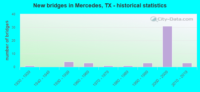
- New bridges - historical statistics
- 11930-1939
- 41950-1959
- 31960-1969
- 11970-1979
- 11980-1989
- 31990-1999
- 312000-2009
- 32010-2019

- Reconstructed bridges - Historical Statistics
- 11970-1979
- 01980-1989
- 11990-1999


- Bridge Condition - Deck
- 56.3%Good
- 43.8%Satisfactory

- Bridge Condition - Superstructure
- 43.8%Very good
- 31.3%Good
- 25.0%Satisfactory

- Bridge Condition - Substructure
- 3.1%Very good
- 71.9%Good
- 18.8%Satisfactory
- 6.3%Fair

- Bridge Condition - Channel
- 56.0%Good
- 28.0%Satisfactory
- 16.0%Fair

- Bridge Condition - Culverts
- 25.0%Very good
- 75.0%Good
Find on map >> Show street view
Structure Number: 210310003919183, Location: AT HIDALGO CO LINE (Lat: 26.159392, Lng: -97.861744), Route carried "on" structure: County highway , Year Built: 1969, Status: Open, Structure Length: 11.58m (37.99ft), Average Daily Traffic: 739 (year 2019), Average Future Daily Traffic: 300 (year 2031), Design Load: HS 20, Features Intersected: US 83, Facility Carried by Structure: MILE 3 EAST RD
Minimum Vertical Clearance: 30+ m (98+ ft), Kilometerpoint: 0.805, Lanes on structure: 2, Lanes under structure: 12, Owner: State Highway Agency, Approaching Roadway Width: 12.2m (40.0ft), Material/Design: Prestressed concrete, Design/Construction: Stringer/Multi-beam, Number Of Spans In Main Unit: 4, Number Of Approach Spans: 2, Length of Maximum Span: 23.8m (78.1ft), Curb-To-Curb Width: 12.2m (40.0ft), Out-to-Out Width: 12.9m (42.3ft)
Condition: Deck: Good, Superstructure: Good, Substructure: Good, Operating Rating: 44.4 metric tons, Method Used To Determine Operating Rating: Assigned ratings based on Allowable Stress Design (ASD) reported in metric tons, Inventory Rating: 32.7 metric tons, Method Used To Determine Inventory Rating: Assigned ratings based on Allowable Stress Design (ASD) reported in metric tons, Structural Evaluation: Better than present minimum criteria, Deck Geometry: Equal to present desirable criteria, Underclear: Equal to present minimum criteria, Approach Roadway Alignment: Equal to present desirable criteria, Designated Inspection Frequency: Every 24 months, Inspection Date: March 2021, Deck Structure Type: Concrete Cast-file-Place
Find on map >> Show street view
Structure Number: 211090003904026, Location: 1.95 MI E OF FM 1015 (Lat: 26.149794, Lng: -97.928275), Route carried "on" structure: Business State highway 83, Year Built: 1937, Year Reconstructed: 1982, Status: Open, Structure Length: 47.55m (156.00ft), Average Daily Traffic: 6,969 (year 2020), Truck Traffic: 1%, Average Future Daily Traffic: 11,410 (year 2033), Design Load: H 15, Features Intersected: NORTH FLOODWAY
Minimum Vertical Clearance: 30+ m (98+ ft), Kilometerpoint: 25.843, Lanes on structure: 4, Owner: State Highway Agency, Approaching Roadway Width: 20.7m (67.9ft), Material/Design: Concrete, Design/Construction: Tee Beam, Number Of Spans In Main Unit: 52, Length of Maximum Span: 9.1m (29.9ft), Curb-To-Curb Width: 20.7m (67.9ft), Out-to-Out Width: 21.3m (69.9ft)
Condition: Deck: Good, Superstructure: Satisfactory, Substructure: Good, Channel: Good, Operating Rating: 54.4 metric tons, Method Used To Determine Operating Rating: Load Factor (LF), Inventory Rating: 32.7 metric tons, Method Used To Determine Inventory Rating: Load Factor (LF), Structural Evaluation: Equal to present minimum criteria, Deck Geometry: Superior to present desirable criteria, Waterway Adequacy: Superior to present desirable criteria, Approach Roadway Alignment: Equal to present desirable criteria, Designated Inspection Frequency: Every 24 months, Inspection Date: May 2021, Deck Structure Type: Concrete Cast-file-Place, Wearing Surface/Protective System: Wearing Surface: Bituminous
Find on map >> Show street view
Structure Number: 211090003904322, Location: 2.00 MI W OF FM 1425 (Lat: 26.149911, Lng: -97.909839), Route carried "on" structure: Business State highway 83, Year Built: 2015, Status: Open, Structure Length: 4.57m (14.99ft), Average Daily Traffic: 7,498 (year 2020), Truck Traffic: 3%, Average Future Daily Traffic: 12,180 (year 2031), Design Load: HL 93, Features Intersected: MERCEDES MAIN CANAL
Minimum Vertical Clearance: 30+ m (98+ ft), Kilometerpoint: 27.921, Lanes on structure: 4, Owner: State Highway Agency, Approaching Roadway Width: 19.5m (64.0ft), Material/Design: Prestressed concrete, Design/Construction: Stringer/Multi-beam, Number Of Spans In Main Unit: 2, Length of Maximum Span: 22.9m (75.1ft), Curb or Sidewalk Widths: Left: 1.5m (4.9ft), Right: 1.5m (4.9ft), Curb-To-Curb Width: 19.5m (64.0ft), Out-to-Out Width: 23.8m (78.1ft)
Condition: Deck: Good, Superstructure: Very good, Substructure: Very good, Channel: Good, Operating Rating: 54.4 metric tons, Method Used To Determine Operating Rating: Assigned ratings based on Load and Resistance Factor Design (LRFD) reported in metric tons, Inventory Rating: 32.7 metric tons, Method Used To Determine Inventory Rating: Assigned ratings based on Load and Resistance Factor Design (LRFD) reported in metric tons, Structural Evaluation: Equal to present desirable criteria, Deck Geometry: Better than present minimum criteria, Waterway Adequacy: Equal to present minimum criteria, Approach Roadway Alignment: Equal to present desirable criteria, Designated Inspection Frequency: Every 24 months, Underwater Inspection Frequency: Every 60 months, Inspection Date: May 2021, Underwater Inspection Date: August 2020, Deck Structure Type: Concrete Cast-file-Place
Find on map >> Show street view
Structure Number: 211090003918409, Location: 1.10 MI SE OF FM 1015 (Lat: 26.153336, Lng: -97.941794), Route carried "on" structure: US 83, Year Built: 2008, Status: Open, Structure Length: 9.57m (31.40ft), Average Daily Traffic: 25,280 (year 2011), Truck Traffic: 18%, Average Future Daily Traffic: 48,820 (year 2031), Design Load: HS 25 or greater, Features Intersected: SP 31 (MILE 2 WEST RD)
Minimum Vertical Clearance: 30+ m (98+ ft), Kilometerpoint: 69.252, Lanes on structure: 4, Lanes under structure: 8, Owner: State Highway Agency, Approaching Roadway Width: 20.7m (67.9ft), Skew: 2 degrees, Material/Design: Prestressed concrete, Design/Construction: Stringer/Multi-beam, Number Of Spans In Main Unit: 2, Number Of Approach Spans: 1, Length of Maximum Span: 39.0m (128.0ft), Curb-To-Curb Width: 20.7m (67.9ft), Out-to-Out Width: 21.6m (70.9ft)
Condition: Deck: Satisfactory, Superstructure: Good, Substructure: Good, Operating Rating: 68.0 metric tons, Method Used To Determine Operating Rating: Assigned rating based on Load Factor Design (LFD) reported in metric tons, Inventory Rating: 40.8 metric tons, Method Used To Determine Inventory Rating: Assigned rating based on Load Factor Design (LFD) reported in metric tons, Structural Evaluation: Better than present minimum criteria, Deck Geometry: Equal to present minimum criteria, Underclear: Equal to present minimum criteria, Approach Roadway Alignment: Equal to present desirable criteria, Designated Inspection Frequency: Every 24 months, Inspection Date: May 2021, Deck Structure Type: Concrete Cast-file-Place
Find on map >> Show street view
Structure Number: 21109000391841, Location: 1.10 MI SE OF FM 1015 (Lat: 26.153347, Lng: -97.942633), Route carried "on" structure: US 83, Year Built: 2008, Status: Open, Structure Length: 9.57m (31.40ft), Average Daily Traffic: 25,280 (year 2011), Truck Traffic: 16%, Average Future Daily Traffic: 48,820 (year 2031), Design Load: HS 25 or greater, Features Intersected: SP 31 (MILE 2 WEST RD)
Minimum Vertical Clearance: 30+ m (98+ ft), Kilometerpoint: 69.269, Lanes on structure: 4, Lanes under structure: 8, Owner: State Highway Agency, Approaching Roadway Width: 20.7m (67.9ft), Skew: 2 degrees, Material/Design: Prestressed concrete, Design/Construction: Stringer/Multi-beam, Number Of Spans In Main Unit: 2, Number Of Approach Spans: 1, Length of Maximum Span: 39.0m (128.0ft), Curb-To-Curb Width: 20.7m (67.9ft), Out-to-Out Width: 21.6m (70.9ft)
Condition: Deck: Satisfactory, Superstructure: Very good, Substructure: Good, Operating Rating: 68.0 metric tons, Method Used To Determine Operating Rating: Assigned rating based on Load Factor Design (LFD) reported in metric tons, Inventory Rating: 40.8 metric tons, Method Used To Determine Inventory Rating: Assigned rating based on Load Factor Design (LFD) reported in metric tons, Structural Evaluation: Better than present minimum criteria, Deck Geometry: Equal to present minimum criteria, Underclear: Equal to present minimum criteria, Approach Roadway Alignment: Equal to present desirable criteria, Designated Inspection Frequency: Every 24 months, Inspection Date: May 2021, Deck Structure Type: Concrete Cast-file-Place
Find on map >> Show street view
Structure Number: 211090003918411, Location: 0.9 MI E OF SP31 (Lat: 26.153061, Lng: -97.926572), Route carried "on" structure: US 83, Year Built: 2007, Status: Open, Structure Length: 50.11m (164.40ft), Average Daily Traffic: 25,710 (year 2011), Truck Traffic: 10%, Average Future Daily Traffic: 40,110 (year 2031), Design Load: HS 25 or greater, Features Intersected: NORTH FLOODWAY CHANNEL
Minimum Vertical Clearance: 30+ m (98+ ft), Kilometerpoint: 70.407, Lanes on structure: 3, Owner: State Highway Agency, Approaching Roadway Width: 17.1m (56.1ft), Skew: 9 degrees, Material/Design: Prestressed concrete, Design/Construction: Stringer/Multi-beam, Number Of Spans In Main Unit: 14, Number Of Approach Spans: 2, Length of Maximum Span: 35.1m (115.2ft), Curb-To-Curb Width: 17.3m (56.8ft), Out-to-Out Width: 18.0m (59.1ft)
Condition: Deck: Good, Superstructure: Very good, Substructure: Good, Channel: Good, Operating Rating: 68.0 metric tons, Method Used To Determine Operating Rating: Assigned rating based on Load Factor Design (LFD) reported in metric tons, Inventory Rating: 40.8 metric tons, Method Used To Determine Inventory Rating: Assigned rating based on Load Factor Design (LFD) reported in metric tons, Structural Evaluation: Better than present minimum criteria, Deck Geometry: Better than present minimum criteria, Waterway Adequacy: Superior to present desirable criteria, Approach Roadway Alignment: Equal to present desirable criteria, Designated Inspection Frequency: Every 24 months, Inspection Date: May 2021, Deck Structure Type: Concrete Precast Panels
Find on map >> Show street view
Structure Number: 211090003918412, Location: 0.9 MI E OF SP31 (Lat: 26.151667, Lng: -97.931164), Route carried "on" structure: US 83, Year Built: 2007, Status: Open, Structure Length: 50.11m (164.40ft), Average Daily Traffic: 25,710 (year 2011), Truck Traffic: 10%, Average Future Daily Traffic: 40,110 (year 2031), Design Load: HS 25 or greater, Features Intersected: NORTH FLOODWAY CHANNEL
Minimum Vertical Clearance: 30+ m (98+ ft), Kilometerpoint: 70.427, Lanes on structure: 3, Owner: State Highway Agency, Approaching Roadway Width: 17.1m (56.1ft), Skew: 9 degrees, Material/Design: Prestressed concrete, Design/Construction: Stringer/Multi-beam, Number Of Spans In Main Unit: 14, Number Of Approach Spans: 2, Length of Maximum Span: 35.1m (115.2ft), Curb-To-Curb Width: 17.3m (56.8ft), Out-to-Out Width: 18.0m (59.1ft)
Condition: Deck: Good, Superstructure: Very good, Substructure: Good, Channel: Good, Operating Rating: 68.0 metric tons, Method Used To Determine Operating Rating: Assigned rating based on Load Factor Design (LFD) reported in metric tons, Inventory Rating: 40.8 metric tons, Method Used To Determine Inventory Rating: Assigned rating based on Load Factor Design (LFD) reported in metric tons, Structural Evaluation: Better than present minimum criteria, Deck Geometry: Better than present minimum criteria, Waterway Adequacy: Superior to present desirable criteria, Approach Roadway Alignment: Equal to present desirable criteria, Designated Inspection Frequency: Every 24 months, Inspection Date: May 2021, Deck Structure Type: Concrete Precast Panels
Find on map >> Show street view
Structure Number: 211090003918413, Location: 0.9 MI E OF SP31 (Lat: 26.153197, Lng: -97.926664), Route carried "on" structure: ServiceUS 83, Year Built: 2006, Status: Open, Structure Length: 52.24m (171.39ft), Average Daily Traffic: 5,150 (year 2011), Truck Traffic: 11%, Average Future Daily Traffic: 9,140 (year 2031), Design Load: HS 25 or greater, Features Intersected: NORTH FLOODWAY CHANNEL
Minimum Vertical Clearance: 30+ m (98+ ft), Kilometerpoint: 69.812, Lanes on structure: 2, Owner: State Highway Agency, Approaching Roadway Width: 12.2m (40.0ft), Skew: 9 degrees, Material/Design: Prestressed concrete, Design/Construction: Stringer/Multi-beam, Number Of Spans In Main Unit: 16, Length of Maximum Span: 35.1m (115.2ft), Curb-To-Curb Width: 12.2m (40.0ft), Out-to-Out Width: 12.8m (42.0ft)
Condition: Deck: Good, Superstructure: Good, Substructure: Good, Channel: Good, Operating Rating: 68.0 metric tons, Method Used To Determine Operating Rating: Assigned rating based on Load Factor Design (LFD) reported in metric tons, Inventory Rating: 40.8 metric tons, Method Used To Determine Inventory Rating: Assigned rating based on Load Factor Design (LFD) reported in metric tons, Structural Evaluation: Better than present minimum criteria, Deck Geometry: Better than present minimum criteria, Waterway Adequacy: Superior to present desirable criteria, Approach Roadway Alignment: Equal to present desirable criteria, Designated Inspection Frequency: Every 24 months, Inspection Date: May 2021, Deck Structure Type: Concrete Precast Panels
Find on map >> Show street view
Structure Number: 211090003918414, Location: 0.50 MI W OF FM 491 (Lat: 26.154672, Lng: -97.920375), Route carried "on" structure: US 83, Year Built: 2008, Status: Open, Structure Length: 6.07m (19.91ft), Average Daily Traffic: 25,790 (year 2011), Truck Traffic: 11%, Average Future Daily Traffic: 45,800 (year 2031), Design Load: HS 25 or greater, Features Intersected: VERMONT AVE
Minimum Vertical Clearance: 30+ m (98+ ft), Kilometerpoint: 71.506, Lanes on structure: 4, Lanes under structure: 6, Owner: State Highway Agency, Approaching Roadway Width: 20.7m (67.9ft), Skew: 1 degrees, Material/Design: Prestressed concrete, Design/Construction: Stringer/Multi-beam, Number Of Spans In Main Unit: 1, Number Of Approach Spans: 2, Length of Maximum Span: 30.2m (99.1ft), Curb-To-Curb Width: 21.2m (69.6ft), Out-to-Out Width: 22.1m (72.5ft)
Condition: Deck: Good, Superstructure: Good, Substructure: Satisfactory, Operating Rating: 68.0 metric tons, Method Used To Determine Operating Rating: Assigned rating based on Load Factor Design (LFD) reported in metric tons, Inventory Rating: 40.8 metric tons, Method Used To Determine Inventory Rating: Assigned rating based on Load Factor Design (LFD) reported in metric tons, Structural Evaluation: Equal to present minimum criteria, Deck Geometry: Better than present minimum criteria, Underclear: Superior to present desirable criteria, Approach Roadway Alignment: Equal to present desirable criteria, Designated Inspection Frequency: Every 24 months, Inspection Date: May 2021, Deck Structure Type: Concrete Cast-file-Place
Find on map >> Show street view
Structure Number: 211090003918415, Location: 0.50 MI W OF FM 491 (Lat: 26.154236, Lng: -97.920914), Route carried "on" structure: US 83, Year Built: 2008, Status: Open, Structure Length: 6.07m (19.91ft), Average Daily Traffic: 25,790 (year 2011), Truck Traffic: 11%, Average Future Daily Traffic: 45,800 (year 2031), Design Load: HS 25 or greater, Features Intersected: VERMONT AVE
Minimum Vertical Clearance: 30+ m (98+ ft), Kilometerpoint: 71.506, Lanes on structure: 4, Lanes under structure: 6, Owner: State Highway Agency, Approaching Roadway Width: 20.7m (67.9ft), Skew: 1 degrees, Material/Design: Prestressed concrete, Design/Construction: Stringer/Multi-beam, Number Of Spans In Main Unit: 1, Number Of Approach Spans: 2, Length of Maximum Span: 30.2m (99.1ft), Curb-To-Curb Width: 20.7m (67.9ft), Out-to-Out Width: 21.6m (70.9ft)
Condition: Deck: Good, Superstructure: Good, Substructure: Good, Operating Rating: 68.0 metric tons, Method Used To Determine Operating Rating: Assigned rating based on Load Factor Design (LFD) reported in metric tons, Inventory Rating: 40.8 metric tons, Method Used To Determine Inventory Rating: Assigned rating based on Load Factor Design (LFD) reported in metric tons, Structural Evaluation: Better than present minimum criteria, Deck Geometry: Equal to present minimum criteria, Underclear: Superior to present desirable criteria, Approach Roadway Alignment: Equal to present desirable criteria, Designated Inspection Frequency: Every 24 months, Inspection Date: May 2021, Deck Structure Type: Concrete Cast-file-Place
Find on map >> Show street view
Structure Number: 211090003918416, Location: 0.9 MI E OF SP31 (Lat: 26.151514, Lng: -97.930975), Route carried "on" structure: ServiceUS 83, Year Built: 2006, Status: Open, Structure Length: 48.98m (160.70ft), Average Daily Traffic: 6,969 (year 2020), Truck Traffic: 11%, Average Future Daily Traffic: 9,140 (year 2031), Design Load: HS 25 or greater, Features Intersected: NORTH FLOODWAY CHANNEL
Minimum Vertical Clearance: 30+ m (98+ ft), Kilometerpoint: 69.812, Lanes on structure: 2, Owner: State Highway Agency, Approaching Roadway Width: 12.2m (40.0ft), Skew: 9 degrees, Material/Design: Prestressed concrete, Design/Construction: Stringer/Multi-beam, Number Of Spans In Main Unit: 12, Number Of Approach Spans: 4, Length of Maximum Span: 36.0m (118.1ft), Curb-To-Curb Width: 12.2m (40.0ft), Out-to-Out Width: 12.8m (42.0ft)
Condition: Deck: Good, Superstructure: Good, Substructure: Good, Channel: Good, Operating Rating: 68.0 metric tons, Method Used To Determine Operating Rating: Assigned rating based on Load Factor Design (LFD) reported in metric tons, Inventory Rating: 40.8 metric tons, Method Used To Determine Inventory Rating: Assigned rating based on Load Factor Design (LFD) reported in metric tons, Structural Evaluation: Better than present minimum criteria, Deck Geometry: Better than present minimum criteria, Waterway Adequacy: Superior to present desirable criteria, Approach Roadway Alignment: Equal to present desirable criteria, Designated Inspection Frequency: Every 24 months, Inspection Date: May 2021, Deck Structure Type: Concrete Precast Panels
Find on map >> Show street view
Structure Number: 211090003918417, Location: 2.20 MI W OF FM 1425 (Lat: 26.156639, Lng: -97.913253), Route carried "on" structure: US 83, Year Built: 2008, Status: Open, Structure Length: 6.86m (22.51ft), Average Daily Traffic: 25,790 (year 2011), Truck Traffic: 11%, Average Future Daily Traffic: 45,800 (year 2031), Design Load: HS 25 or greater, Features Intersected: FM 491
Minimum Vertical Clearance: 30+ m (98+ ft), Kilometerpoint: 72.240, Lanes on structure: 4, Lanes under structure: 8, Owner: State Highway Agency, Approaching Roadway Width: 21.0m (68.9ft), Skew: 1 degrees, Material/Design: Prestressed concrete, Design/Construction: Stringer/Multi-beam, Number Of Spans In Main Unit: 1, Number Of Approach Spans: 2, Length of Maximum Span: 35.7m (117.1ft), Curb-To-Curb Width: 21.1m (69.2ft), Out-to-Out Width: 22.0m (72.2ft)
Condition: Deck: Good, Superstructure: Very good, Substructure: Good, Operating Rating: 68.0 metric tons, Method Used To Determine Operating Rating: Assigned rating based on Load Factor Design (LFD) reported in metric tons, Inventory Rating: 40.8 metric tons, Method Used To Determine Inventory Rating: Assigned rating based on Load Factor Design (LFD) reported in metric tons, Structural Evaluation: Better than present minimum criteria, Deck Geometry: Better than present minimum criteria, Underclear: Equal to present minimum criteria, Approach Roadway Alignment: Equal to present desirable criteria, Designated Inspection Frequency: Every 24 months, Inspection Date: May 2021, Deck Structure Type: Concrete Cast-file-Place
Find on map >> Show street view
Structure Number: 211090003918418, Location: 2.20 MI W OF FM 1425 (Lat: 26.156119, Lng: -97.913892), Route carried "on" structure: US 83, Year Built: 2008, Status: Open, Structure Length: 6.86m (22.51ft), Average Daily Traffic: 25,790 (year 2011), Truck Traffic: 11%, Average Future Daily Traffic: 45,800 (year 2031), Design Load: HS 25 or greater, Features Intersected: FM 491
Minimum Vertical Clearance: 30+ m (98+ ft), Kilometerpoint: 72.240, Lanes on structure: 3, Lanes under structure: 8, Owner: State Highway Agency, Approaching Roadway Width: 17.1m (56.1ft), Skew: 1 degrees, Material/Design: Prestressed concrete, Design/Construction: Stringer/Multi-beam, Number Of Spans In Main Unit: 1, Number Of Approach Spans: 2, Length of Maximum Span: 35.7m (117.1ft), Curb-To-Curb Width: 17.1m (56.1ft), Out-to-Out Width: 18.0m (59.1ft)
Condition: Deck: Good, Superstructure: Good, Substructure: Good, Operating Rating: 68.0 metric tons, Method Used To Determine Operating Rating: Assigned rating based on Load Factor Design (LFD) reported in metric tons, Inventory Rating: 40.8 metric tons, Method Used To Determine Inventory Rating: Assigned rating based on Load Factor Design (LFD) reported in metric tons, Structural Evaluation: Better than present minimum criteria, Deck Geometry: Equal to present minimum criteria, Underclear: Equal to present minimum criteria, Approach Roadway Alignment: Equal to present desirable criteria, Designated Inspection Frequency: Every 24 months, Inspection Date: May 2021, Deck Structure Type: Concrete Cast-file-Place
Find on map >> Show street view
Structure Number: 211090003918419, Location: 0.20 MI E OF FM 491 (Lat: 26.157453, Lng: -97.910275), Route carried "on" structure: US 83, Year Built: 2008, Status: Open, Structure Length: 3.41m (11.19ft), Average Daily Traffic: 25,790 (year 2011), Truck Traffic: 11%, Average Future Daily Traffic: 45,800 (year 2031), Design Load: HS 25 or greater, Features Intersected: MERCEDES MAIN CANAL
Minimum Vertical Clearance: 30+ m (98+ ft), Kilometerpoint: 72.581, Lanes on structure: 4, Owner: State Highway Agency, Approaching Roadway Width: 20.7m (67.9ft), Skew: 1 degrees, Material/Design: Prestressed concrete, Design/Construction: Stringer/Multi-beam, Number Of Spans In Main Unit: 1, Length of Maximum Span: 34.1m (111.9ft), Curb-To-Curb Width: 21.0m (68.9ft), Out-to-Out Width: 21.6m (70.9ft)
Condition: Deck: Good, Superstructure: Very good, Substructure: Good, Channel: Good, Operating Rating: 68.0 metric tons, Method Used To Determine Operating Rating: Assigned rating based on Load Factor Design (LFD) reported in metric tons, Inventory Rating: 40.8 metric tons, Method Used To Determine Inventory Rating: Assigned rating based on Load Factor Design (LFD) reported in metric tons, Structural Evaluation: Better than present minimum criteria, Deck Geometry: Better than present minimum criteria, Waterway Adequacy: Equal to present minimum criteria, Approach Roadway Alignment: Equal to present desirable criteria, Designated Inspection Frequency: Every 24 months, Inspection Date: May 2021, Deck Structure Type: Concrete Precast Panels
Find on map >> Show street view
Structure Number: 21109000391842, Location: 0.20 MI E OF FM 491 (Lat: 26.156983, Lng: -97.910608), Route carried "on" structure: US 83, Year Built: 2008, Status: Open, Structure Length: 3.41m (11.19ft), Average Daily Traffic: 25,790 (year 2011), Truck Traffic: 11%, Average Future Daily Traffic: 45,800 (year 2031), Design Load: HS 25 or greater, Features Intersected: MERCEDES MAIN CANAL
Minimum Vertical Clearance: 30+ m (98+ ft), Kilometerpoint: 72.581, Lanes on structure: 3, Owner: State Highway Agency, Approaching Roadway Width: 17.1m (56.1ft), Skew: 1 degrees, Material/Design: Prestressed concrete, Design/Construction: Stringer/Multi-beam, Number Of Spans In Main Unit: 1, Length of Maximum Span: 34.1m (111.9ft), Curb-To-Curb Width: 17.3m (56.8ft), Out-to-Out Width: 18.0m (59.1ft)
Condition: Deck: Good, Superstructure: Very good, Substructure: Good, Channel: Good, Operating Rating: 68.0 metric tons, Method Used To Determine Operating Rating: Assigned rating based on Load Factor Design (LFD) reported in metric tons, Inventory Rating: 40.8 metric tons, Method Used To Determine Inventory Rating: Assigned rating based on Load Factor Design (LFD) reported in metric tons, Structural Evaluation: Better than present minimum criteria, Deck Geometry: Better than present minimum criteria, Waterway Adequacy: Equal to present minimum criteria, Approach Roadway Alignment: Equal to present desirable criteria, Designated Inspection Frequency: Every 24 months, Inspection Date: May 2021, Deck Structure Type: Concrete Precast Panels
Find on map >> Show street view
Structure Number: 211090003918421, Location: 0.20 MI E OF FM 491 (Lat: 26.157589, Lng: -97.910325), Route carried "on" structure: ServiceUS 83, Year Built: 2008, Status: Open, Structure Length: 3.38m (11.09ft), Average Daily Traffic: 5,631 (year 2019), Truck Traffic: 11%, Average Future Daily Traffic: 9,140 (year 2031), Design Load: HS 25 or greater, Features Intersected: MERCEDES MAIN CANAL
Minimum Vertical Clearance: 30+ m (98+ ft), Kilometerpoint: 72.589, Lanes on structure: 3, Owner: State Highway Agency, Approaching Roadway Width: 12.2m (40.0ft), Skew: 1 degrees, Material/Design: Prestressed concrete, Design/Construction: Box Beam or Girders - Multiple, Number Of Spans In Main Unit: 1, Length of Maximum Span: 33.8m (110.9ft), Curb-To-Curb Width: 12.2m (40.0ft), Out-to-Out Width: 12.8m (42.0ft)
Condition: Deck: Good, Superstructure: Very good, Substructure: Good, Channel: Good, Operating Rating: 68.0 metric tons, Method Used To Determine Operating Rating: Assigned rating based on Load Factor Design (LFD) reported in metric tons, Inventory Rating: 40.8 metric tons, Method Used To Determine Inventory Rating: Assigned rating based on Load Factor Design (LFD) reported in metric tons, Structural Evaluation: Better than present minimum criteria, Deck Geometry: High priority of replacement, Waterway Adequacy: Equal to present minimum criteria, Approach Roadway Alignment: Equal to present desirable criteria, Designated Inspection Frequency: Every 24 months, Inspection Date: May 2021, Deck Structure Type: Concrete Cast-file-Place
Find on map >> Show street view
Structure Number: 211090003918422, Location: 0.20 MI E OF FM 491 (Lat: 26.156861, Lng: -97.910550), Route carried "on" structure: ServiceUS 83, Year Built: 2008, Status: Open, Structure Length: 3.38m (11.09ft), Average Daily Traffic: 7,312 (year 2019), Truck Traffic: 11%, Average Future Daily Traffic: 9,140 (year 2031), Design Load: HS 25 or greater, Features Intersected: MERCEDES MAIN CANAL
Minimum Vertical Clearance: 30+ m (98+ ft), Kilometerpoint: 72.589, Lanes on structure: 3, Owner: State Highway Agency, Approaching Roadway Width: 12.2m (40.0ft), Skew: 1 degrees, Material/Design: Prestressed concrete, Design/Construction: Box Beam or Girders - Multiple, Number Of Spans In Main Unit: 1, Length of Maximum Span: 33.8m (110.9ft), Curb-To-Curb Width: 12.2m (40.0ft), Out-to-Out Width: 12.8m (42.0ft)
Condition: Deck: Good, Superstructure: Very good, Substructure: Good, Channel: Fair, Operating Rating: 68.0 metric tons, Method Used To Determine Operating Rating: Assigned rating based on Load Factor Design (LFD) reported in metric tons, Inventory Rating: 40.8 metric tons, Method Used To Determine Inventory Rating: Assigned rating based on Load Factor Design (LFD) reported in metric tons, Structural Evaluation: Better than present minimum criteria, Deck Geometry: High priority of replacement, Waterway Adequacy: Equal to present minimum criteria, Approach Roadway Alignment: Equal to present desirable criteria, Length Of Structure Improvement: 3.38m (11.09ft), Designated Inspection Frequency: Every 24 months, Inspection Date: May 2021, Deck Structure Type: Concrete Cast-file-Place
Find on map >> Show street view
Structure Number: 211090003918423, Location: 1.00 MI W FM1425 (Lat: 26.159281, Lng: -97.893681), Route carried "on" structure: US 83, Year Built: 2008, Status: Open, Structure Length: 7.74m (25.39ft), Average Daily Traffic: 28,791 (year 2017), Truck Traffic: 16%, Average Future Daily Traffic: 51,270 (year 2031), Design Load: HS 25 or greater, Features Intersected: MILE 1 EAST RD
Minimum Vertical Clearance: 30+ m (98+ ft), Kilometerpoint: 74.239, Lanes on structure: 4, Lanes under structure: 4, Owner: State Highway Agency, Approaching Roadway Width: 20.7m (67.9ft), Material/Design: Prestressed concrete, Design/Construction: Stringer/Multi-beam, Number Of Spans In Main Unit: 1, Number Of Approach Spans: 2, Length of Maximum Span: 34.1m (111.9ft), Curb-To-Curb Width: 20.7m (67.9ft), Out-to-Out Width: 21.6m (70.9ft)
Condition: Deck: Satisfactory, Superstructure: Very good, Substructure: Good, Operating Rating: 68.0 metric tons, Method Used To Determine Operating Rating: Assigned rating based on Load Factor Design (LFD) reported in metric tons, Inventory Rating: 40.8 metric tons, Method Used To Determine Inventory Rating: Assigned rating based on Load Factor Design (LFD) reported in metric tons, Structural Evaluation: Better than present minimum criteria, Deck Geometry: Equal to present minimum criteria, Underclear: Superior to present desirable criteria, Approach Roadway Alignment: Equal to present desirable criteria, Designated Inspection Frequency: Every 24 months, Inspection Date: May 2021, Deck Structure Type: Concrete Cast-file-Place
Find on map >> Show street view
Structure Number: 211090003918424, Location: 1.00 MI W OF FM 1425 (Lat: 26.158878, Lng: -97.894406), Route carried "on" structure: US 83, Year Built: 2008, Status: Open, Structure Length: 7.74m (25.39ft), Average Daily Traffic: 27,825 (year 2017), Truck Traffic: 9%, Average Future Daily Traffic: 51,270 (year 2031), Design Load: HS 25 or greater, Features Intersected: MILE 1 EAST RD
Minimum Vertical Clearance: 30+ m (98+ ft), Kilometerpoint: 74.239, Lanes on structure: 4, Lanes under structure: 4, Owner: State Highway Agency, Approaching Roadway Width: 20.7m (67.9ft), Material/Design: Prestressed concrete, Design/Construction: Stringer/Multi-beam, Number Of Spans In Main Unit: 1, Number Of Approach Spans: 2, Length of Maximum Span: 34.1m (111.9ft), Curb-To-Curb Width: 20.7m (67.9ft), Out-to-Out Width: 21.6m (70.9ft)
Condition: Deck: Satisfactory, Superstructure: Very good, Substructure: Good, Operating Rating: 68.0 metric tons, Method Used To Determine Operating Rating: Assigned rating based on Load Factor Design (LFD) reported in metric tons, Inventory Rating: 40.8 metric tons, Method Used To Determine Inventory Rating: Assigned rating based on Load Factor Design (LFD) reported in metric tons, Structural Evaluation: Better than present minimum criteria, Deck Geometry: Equal to present minimum criteria, Underclear: Superior to present desirable criteria, Approach Roadway Alignment: Equal to present desirable criteria, Designated Inspection Frequency: Every 24 months, Inspection Date: May 2021, Deck Structure Type: Concrete Cast-file-Place
Find on map >> Show street view
Structure Number: 211090003918425, Location: JCT OF US 83 & FM 1425 (Lat: 26.159528, Lng: -97.877656), Route carried "on" structure: US 83, Year Built: 2007, Status: Open, Structure Length: 6.52m (21.39ft), Average Daily Traffic: 48,000 (year 2011), Truck Traffic: 10%, Average Future Daily Traffic: 75,000 (year 2031), Design Load: HS 25 or greater, Features Intersected: FM 1425 (MILE 2 EAST RD)
Minimum Vertical Clearance: 30+ m (98+ ft), Kilometerpoint: 75.848, Lanes on structure: 4, Lanes under structure: 4, Owner: State Highway Agency, Approaching Roadway Width: 20.7m (67.9ft), Material/Design: Prestressed concrete, Design/Construction: Stringer/Multi-beam, Number Of Spans In Main Unit: 1, Number Of Approach Spans: 2, Length of Maximum Span: 34.1m (111.9ft), Curb-To-Curb Width: 20.7m (67.9ft), Out-to-Out Width: 21.6m (70.9ft)
Condition: Deck: Satisfactory, Superstructure: Very good, Substructure: Good, Operating Rating: 68.0 metric tons, Method Used To Determine Operating Rating: Assigned rating based on Load Factor Design (LFD) reported in metric tons, Inventory Rating: 40.8 metric tons, Method Used To Determine Inventory Rating: Assigned rating based on Load Factor Design (LFD) reported in metric tons, Structural Evaluation: Better than present minimum criteria, Deck Geometry: Equal to present minimum criteria, Underclear: Superior to present desirable criteria, Approach Roadway Alignment: Equal to present desirable criteria, Designated Inspection Frequency: Every 24 months, Inspection Date: May 2021, Deck Structure Type: Concrete Cast-file-Place
Find on map >> Show street view
Structure Number: 211090003918426, Location: JCT OF US 83 & FM 1425 (Lat: 26.159150, Lng: -97.878264), Route carried "on" structure: US 83, Year Built: 2007, Status: Open, Structure Length: 6.52m (21.39ft), Average Daily Traffic: 48,000 (year 2011), Truck Traffic: 10%, Average Future Daily Traffic: 75,000 (year 2031), Design Load: HS 25 or greater, Features Intersected: FM 1425 (MILE 2 EAST RD)
Minimum Vertical Clearance: 30+ m (98+ ft), Kilometerpoint: 75.848, Lanes on structure: 4, Lanes under structure: 4, Owner: State Highway Agency, Approaching Roadway Width: 20.7m (67.9ft), Material/Design: Prestressed concrete, Design/Construction: Stringer/Multi-beam, Number Of Spans In Main Unit: 1, Number Of Approach Spans: 2, Length of Maximum Span: 34.1m (111.9ft), Curb-To-Curb Width: 20.7m (67.9ft), Out-to-Out Width: 21.6m (70.9ft)
Condition: Deck: Satisfactory, Superstructure: Very good, Substructure: Good, Operating Rating: 68.0 metric tons, Method Used To Determine Operating Rating: Assigned rating based on Load Factor Design (LFD) reported in metric tons, Inventory Rating: 40.8 metric tons, Method Used To Determine Inventory Rating: Assigned rating based on Load Factor Design (LFD) reported in metric tons, Structural Evaluation: Better than present minimum criteria, Deck Geometry: Equal to present minimum criteria, Underclear: Superior to present desirable criteria, Approach Roadway Alignment: Equal to present desirable criteria, Designated Inspection Frequency: Every 24 months, Inspection Date: May 2021, Deck Structure Type: Concrete Cast-file-Place
Find on map >> Show street view
Structure Number: 211090086101014, Location: 0.30 MI N OF US 83 (Lat: 26.158864, Lng: -97.910486), Route carried "on" structure: State highway 491, Year Built: 1994, Status: Open, Structure Length: 0.67m (2.20ft), Average Daily Traffic: 11,132 (year 2020), Truck Traffic: 7%, Average Future Daily Traffic: 9,630 (year 2025), Design Load: HS 20, Features Intersected: MERCEDES MAIN CANAL
Minimum Vertical Clearance: 30+ m (98+ ft), Kilometerpoint: 34.500, Lanes on structure: 2, Owner: State Highway Agency, Approaching Roadway Width: 14.0m (45.9ft), Skew: 4 degrees, Material/Design: Concrete, Design/Construction: Culvert, Number Of Spans In Main Unit: 2, Length of Maximum Span: 2.1m (6.9ft)
Condition: Channel: Good, Culverts: Good, Operating Rating: 39.9 metric tons, Method Used To Determine Operating Rating: Load Factor (LF), Inventory Rating: 23.6 metric tons, Method Used To Determine Inventory Rating: Load Factor (LF), Structural Evaluation: Somewhat better than minimum adequacy, Waterway Adequacy: Equal to present minimum criteria, Approach Roadway Alignment: Equal to present desirable criteria, Designated Inspection Frequency: Every 48 months, Underwater Inspection Frequency: Every 60 months, Inspection Date: May 2021, Underwater Inspection Date: August 2020
Find on map >> Show street view
Structure Number: 211090086101015, Location: 0.29 MI N OF US 83 (Lat: 26.158922, Lng: -97.910550), Route carried "on" structure: State highway 491, Year Built: 1994, Status: Open, Structure Length: 0.67m (2.20ft), Average Daily Traffic: 11,132 (year 2020), Truck Traffic: 5%, Average Future Daily Traffic: 11,870 (year 2033), Design Load: HS 20, Features Intersected: MERCEDES MAIN CANAL
Minimum Vertical Clearance: 30+ m (98+ ft), Kilometerpoint: 34.554, Lanes on structure: 2, Owner: State Highway Agency, Approaching Roadway Width: 14.0m (45.9ft), Skew: 4 degrees, Material/Design: Concrete, Design/Construction: Culvert, Number Of Spans In Main Unit: 2, Length of Maximum Span: 2.1m (6.9ft)
Condition: Channel: Good, Culverts: Very good, Operating Rating: 39.9 metric tons, Method Used To Determine Operating Rating: Load Factor (LF), Inventory Rating: 23.6 metric tons, Method Used To Determine Inventory Rating: Load Factor (LF), Structural Evaluation: Somewhat better than minimum adequacy, Waterway Adequacy: Equal to present minimum criteria, Approach Roadway Alignment: Equal to present desirable criteria, Designated Inspection Frequency: Every 48 months, Underwater Inspection Frequency: Every 60 months, Inspection Date: May 2021, Underwater Inspection Date: August 2020
Find on map >> Show street view
Structure Number: 211090086101017, Location: 2.7 MI N OF US 83 (Lat: 26.194469, Lng: -97.910764), Route carried "on" structure: State highway 491, Year Built: 2007, Status: Open, Structure Length: 2.29m (7.51ft), Average Daily Traffic: 2,704 (year 2020), Truck Traffic: 35%, Average Future Daily Traffic: 3,300 (year 2033), Design Load: HS 20, Features Intersected: MERCEDES CANAL
Minimum Vertical Clearance: 30+ m (98+ ft), Kilometerpoint: 30.634, Lanes on structure: 2, Owner: State Highway Agency, Approaching Roadway Width: 12.8m (42.0ft), Skew: 3 degrees, Material/Design: Prestressed concrete, Design/Construction: Box Beam or Girders - Multiple, Number Of Spans In Main Unit: 1, Length of Maximum Span: 22.9m (75.1ft), Curb-To-Curb Width: 13.3m (43.6ft), Out-to-Out Width: 14.0m (45.9ft)
Condition: Deck: Good, Superstructure: Good, Substructure: Good, Channel: Good, Operating Rating: 54.4 metric tons, Method Used To Determine Operating Rating: Assigned rating based on Load Factor Design (LFD) reported in metric tons, Inventory Rating: 32.7 metric tons, Method Used To Determine Inventory Rating: Assigned rating based on Load Factor Design (LFD) reported in metric tons, Structural Evaluation: Better than present minimum criteria, Deck Geometry: Equal to present minimum criteria, Waterway Adequacy: Superior to present desirable criteria, Approach Roadway Alignment: Equal to present desirable criteria, Designated Inspection Frequency: Every 24 months, Inspection Date: May 2021, Deck Structure Type: Concrete Cast-file-Place
Find on map >> Show street view
Structure Number: 211090086105008, Location: 1.50 MI S OF BU 83 (Lat: 26.128119, Lng: -97.901581), Route carried "on" structure: State highway 491, Year Built: 1957, Year Reconstructed: 2002, Status: Open, Structure Length: 7.41m (24.31ft), Average Daily Traffic: 9,017 (year 2019), Truck Traffic: 3%, Average Future Daily Traffic: 10,960 (year 2033), Features Intersected: ARROYO COLORADO
Minimum Vertical Clearance: 30+ m (98+ ft), Kilometerpoint: 4.144, Lanes on structure: 2, Owner: State Highway Agency, Approaching Roadway Width: 13.4m (44.0ft), Material/Design: Concrete, Design/Construction: Stringer/Multi-beam, Number Of Spans In Main Unit: 8, Length of Maximum Span: 9.1m (29.9ft), Curb-To-Curb Width: 14.7m (48.2ft), Out-to-Out Width: 15.3m (50.2ft)
Condition: Deck: Good, Superstructure: Good, Substructure: Satisfactory, Channel: Satisfactory, Operating Rating: 68.0 metric tons, Method Used To Determine Operating Rating: Load Factor (LF), Inventory Rating: 40.8 metric tons, Method Used To Determine Inventory Rating: Load Factor (LF), Structural Evaluation: Equal to present minimum criteria, Deck Geometry: Superior to present desirable criteria, Waterway Adequacy: Superior to present desirable criteria, Approach Roadway Alignment: Equal to present desirable criteria, Designated Inspection Frequency: Every 24 months, Inspection Date: May 2021, Deck Structure Type: Concrete Cast-file-Place
Find on map >> Show street view
Structure Number: 211090086105016, Location: 0.30 MI S OF BUS 83 (Lat: 26.145658, Lng: -97.902469), Route carried "on" structure: State highway 491, Year Built: 2002, Status: Open, Structure Length: 1.98m (6.50ft), Average Daily Traffic: 6,198 (year 2020), Truck Traffic: 7%, Average Future Daily Traffic: 11,340 (year 2025), Design Load: HS 20, Features Intersected: ARROYO ANACUITAS
Minimum Vertical Clearance: 30+ m (98+ ft), Kilometerpoint: 2.197, Lanes on structure: 5, Owner: State Highway Agency, Approaching Roadway Width: 19.5m (64.0ft), Skew: 5 degrees, Material/Design: Concrete, Design/Construction: Culvert, Number Of Spans In Main Unit: 3, Length of Maximum Span: 3.0m (9.8ft), Curb or Sidewalk Widths: Left: 1.5m (4.9ft), Right: 1.5m (4.9ft)
Condition: Channel: Satisfactory, Culverts: Good, Operating Rating: 54.4 metric tons, Method Used To Determine Operating Rating: Assigned rating based on Load Factor Design (LFD) reported in metric tons, Inventory Rating: 32.7 metric tons, Method Used To Determine Inventory Rating: Assigned rating based on Load Factor Design (LFD) reported in metric tons, Structural Evaluation: Better than present minimum criteria, Waterway Adequacy: Equal to present minimum criteria, Approach Roadway Alignment: Equal to present desirable criteria, Designated Inspection Frequency: Every 48 months, Inspection Date: May 2021
Find on map >> Show street view
Structure Number: 211090AA0677001, Location: 1.1 MI N OF MILE 4 N RD (Lat: 26.129469, Lng: -97.908717), Route carried "on" structure: County highway , Year Built: 1950, Status: Posted for load, Structure Length: 1.52m (4.99ft), Average Daily Traffic: 113 (year 2014), Average Future Daily Traffic: 350 (year 2032), Features Intersected: ARROYO COLORADO, Facility Carried by Structure: BASE LINE RD
Minimum Vertical Clearance: 30+ m (98+ ft), Kilometerpoint: 4.989, Lanes on structure: 2, Owner: County Highway Agency, Approaching Roadway Width: 4.3m (14.1ft), Material/Design: Concrete, Design/Construction: Slab, Number Of Spans In Main Unit: 2, Length of Maximum Span: 7.6m (24.9ft), Curb-To-Curb Width: 5.5m (18.0ft), Out-to-Out Width: 6.6m (21.7ft)
Condition: Deck: Satisfactory, Superstructure: Satisfactory, Substructure: Fair, Channel: Satisfactory, Operating Rating: 32.7 metric tons, Method Used To Determine Operating Rating: Field evaluation and documented engineering judgment, Inventory Rating: 24.5 metric tons, Method Used To Determine Inventory Rating: Field evaluation and documented engineering judgment, Structural Evaluation: Somewhat better than minimum adequacy, Deck Geometry: High priority of corrective action, Waterway Adequacy: Meets minimum limits, Approach Roadway Alignment: Somewhat better than minimum adequacy, Bridge Posting: Required (Relationship of Operating Rating to Maximum Legal Load: 20.0 - 29.9% below), Length Of Structure Improvement: 1.52m (4.99ft), Designated Inspection Frequency: Every 24 months, Underwater Inspection Frequency: Every 60 months, Inspection Date: April 2020, Underwater Inspection Date: Febuary 2019, Bridge Improvement Cost: $2,000, Roadway Improvement Cost: $1,000, Total Project Cost: $3,000, Deck Structure Type: Concrete Cast-file-Place
Find on map >> Show street view
Structure Number: 211090AA0684001, Location: 0.60 MI E OF FM 491 (Lat: 26.113369, Lng: -97.891083), Route carried "on" structure: County highway , Year Built: 2008, Status: Open, Structure Length: 3.05m (10.01ft), Average Daily Traffic: 500 (year 2010), Truck Traffic: 1%, Average Future Daily Traffic: 350 (year 2032), Design Load: HS 20, Features Intersected: ARROYO COLORADO TRIB, Facility Carried by Structure: MILE 4 N RD
Minimum Vertical Clearance: 30+ m (98+ ft), Kilometerpoint: 1.851, Lanes on structure: 2, Owner: County Highway Agency, Approaching Roadway Width: 7.9m (25.9ft), Skew: 1 degrees, Material/Design: Prestressed concrete, Design/Construction: Slab, Number Of Spans In Main Unit: 2, Length of Maximum Span: 15.2m (49.9ft), Curb-To-Curb Width: 10.4m (34.1ft), Out-to-Out Width: 11.0m (36.1ft)
Condition: Deck: Good, Superstructure: Good, Substructure: Good, Channel: Good, Operating Rating: 54.4 metric tons, Method Used To Determine Operating Rating: Assigned rating based on Load Factor Design (LFD) reported in metric tons, Inventory Rating: 32.7 metric tons, Method Used To Determine Inventory Rating: Assigned rating based on Load Factor Design (LFD) reported in metric tons, Structural Evaluation: Better than present minimum criteria, Deck Geometry: Equal to present minimum criteria, Waterway Adequacy: Better than present minimum criteria, Approach Roadway Alignment: Equal to present desirable criteria, Designated Inspection Frequency: Every 24 months, Inspection Date: April 2020, Deck Structure Type: Concrete Cast-file-Place
Find on map >> Show street view
Structure Number: 211090AA0826001, Location: 0.18 MI EAST OF FM 491 (Lat: 26.142333, Lng: -97.898967), Route carried "on" structure: County highway , Year Built: 1987, Status: Open, Structure Length: 3.87m (12.70ft), Average Daily Traffic: 2,456 (year 2020), Truck Traffic: 5%, Average Future Daily Traffic: 1,600 (year 2032), Design Load: H 20, Features Intersected: NORTH MAIN DRAIN, Facility Carried by Structure: MI 6 N RD (10TH ST
Minimum Vertical Clearance: 30+ m (98+ ft), Kilometerpoint: 0.288, Lanes on structure: 2, Owner: County Highway Agency, Approaching Roadway Width: 7.9m (25.9ft), Skew: 4 degrees, Material/Design: Concrete, Design/Construction: Slab, Number Of Spans In Main Unit: 5, Length of Maximum Span: 7.6m (24.9ft), Curb-To-Curb Width: 7.9m (25.9ft), Out-to-Out Width: 8.5m (27.9ft)
Condition: Deck: Satisfactory, Superstructure: Satisfactory, Substructure: Satisfactory, Channel: Satisfactory, Operating Rating: 55.3 metric tons, Method Used To Determine Operating Rating: Load Factor (LF), Inventory Rating: 32.7 metric tons, Method Used To Determine Inventory Rating: Load Factor (LF), Structural Evaluation: Equal to present minimum criteria, Deck Geometry: High priority of corrective action, Waterway Adequacy: Better than present minimum criteria, Approach Roadway Alignment: Equal to present desirable criteria, Designated Inspection Frequency: Every 24 months, Inspection Date: April 2020, Deck Structure Type: Concrete Cast-file-Place
Find on map >> Show street view
Structure Number: 211090AA0859001, Location: 0.25 MI W OF MILE 1 W RD (Lat: 26.185411, Lng: -97.930825), Route carried "on" structure: County highway , Year Built: 1950, Status: Open, Structure Length: 0.76m (2.49ft), Average Daily Traffic: 253 (year 2020), Truck Traffic: 1%, Average Future Daily Traffic: 125 (year 2032), Features Intersected: IRRIGATION CANAL, Facility Carried by Structure: MILE 9 NORTH ROAD
Minimum Vertical Clearance: 30+ m (98+ ft), Kilometerpoint: 0.402, Lanes on structure: 2, Owner: County Highway Agency, Approaching Roadway Width: 4.9m (16.1ft), Material/Design: Concrete, Design/Construction: Slab, Number Of Spans In Main Unit: 1, Length of Maximum Span: 7.3m (24.0ft), Curb-To-Curb Width: 6.1m (20.0ft), Out-to-Out Width: 7.0m (23.0ft)
Condition: Deck: Satisfactory, Superstructure: Satisfactory, Substructure: Satisfactory, Channel: Satisfactory, Operating Rating: 32.7 metric tons, Method Used To Determine Operating Rating: Field evaluation and documented engineering judgment, Inventory Rating: 24.5 metric tons, Method Used To Determine Inventory Rating: Field evaluation and documented engineering judgment, Structural Evaluation: Equal to present minimum criteria, Deck Geometry: Meets minimum limits, Waterway Adequacy: Better than present minimum criteria, Approach Roadway Alignment: Better than present minimum criteria, Designated Inspection Frequency: Every 24 months, Inspection Date: May 2020, Deck Structure Type: Concrete Cast-file-Place
Find on map >> Show street view
Structure Number: 211090AA0860001, Location: 1.25 MI E OF FM 1015 (Lat: 26.170769, Lng: -97.938525), Route carried "on" structure: County highway , Year Built: 1950, Status: Open, Structure Length: 0.70m (2.30ft), Average Daily Traffic: 303 (year 2019), Truck Traffic: 1%, Average Future Daily Traffic: 200 (year 2032), Features Intersected: IRRIGATION CANAL, Facility Carried by Structure: MILE 8 NORTH ROAD
Minimum Vertical Clearance: 30+ m (98+ ft), Kilometerpoint: 2.012, Lanes on structure: 2, Owner: County Highway Agency, Approaching Roadway Width: 6.4m (21.0ft), Material/Design: Concrete, Design/Construction: Slab, Number Of Spans In Main Unit: 1, Length of Maximum Span: 6.4m (21.0ft), Curb-To-Curb Width: 6.1m (20.0ft), Out-to-Out Width: 7.0m (23.0ft)
Condition: Deck: Satisfactory, Superstructure: Satisfactory, Substructure: Good, Channel: Fair, Operating Rating: 32.7 metric tons, Method Used To Determine Operating Rating: Field evaluation and documented engineering judgment, Inventory Rating: 24.5 metric tons, Method Used To Determine Inventory Rating: Field evaluation and documented engineering judgment, Structural Evaluation: Equal to present minimum criteria, Deck Geometry: Meets minimum limits, Waterway Adequacy: Better than present minimum criteria, Approach Roadway Alignment: Somewhat better than minimum adequacy, Designated Inspection Frequency: Every 24 months, Inspection Date: May 2020, Deck Structure Type: Concrete Cast-file-Place
Find on map >> Show street view
Structure Number: 211090AA0863002, Location: 0.5 MI S OF MILE 9 N ROAD (Lat: 26.178119, Lng: -97.934683), Route carried "on" structure: County highway , Year Built: 1975, Status: Open, Structure Length: 0.70m (2.30ft), Average Daily Traffic: 331 (year 2019), Average Future Daily Traffic: 75 (year 2032), Features Intersected: IRRIGATION CANAL, Facility Carried by Structure: MILE 1-1/2 WEST RD
Minimum Vertical Clearance: 30+ m (98+ ft), Kilometerpoint: 2.414, Lanes on structure: 2, Owner: County Highway Agency, Approaching Roadway Width: 5.5m (18.0ft), Material/Design: Concrete, Design/Construction: Slab, Number Of Spans In Main Unit: 1, Length of Maximum Span: 6.4m (21.0ft), Curb-To-Curb Width: 6.1m (20.0ft), Out-to-Out Width: 7.0m (23.0ft)
Condition: Deck: Satisfactory, Superstructure: Satisfactory, Substructure: Satisfactory, Channel: Fair, Operating Rating: 32.7 metric tons, Method Used To Determine Operating Rating: Field evaluation and documented engineering judgment, Inventory Rating: 24.5 metric tons, Method Used To Determine Inventory Rating: Field evaluation and documented engineering judgment, Structural Evaluation: Equal to present minimum criteria, Deck Geometry: Meets minimum limits, Waterway Adequacy: Better than present minimum criteria, Approach Roadway Alignment: Somewhat better than minimum adequacy, Designated Inspection Frequency: Every 24 months, Inspection Date: May 2020, Deck Structure Type: Concrete Cast-file-Place
Find on map >> Show street view
Structure Number: 211090AA1407001, Location: 1.0 WEST ON LEVEE ROAD (Lat: 26.138708, Lng: -97.875914), Route carried "on" structure: Other road , Year Built: 2016, Status: Open, Structure Length: 0.85m (2.79ft), Average Future Daily Traffic: 1 (year 1900), Design Load: HL 93, Features Intersected: DITCH 21, Facility Carried by Structure: IBWC LEVEE
Minimum Vertical Clearance: 30+ m (98+ ft), Kilometerpoint: 0.000, Lanes on structure: 1, Owner: State Agenciy, Approaching Roadway Width: 4.6m (15.1ft), Material/Design: Concrete, Design/Construction: Culvert, Number Of Spans In Main Unit: 2, Length of Maximum Span: 3.0m (9.8ft)
Condition: Channel: Good, Culverts: Good, Operating Rating: 54.4 metric tons, Method Used To Determine Operating Rating: Assigned ratings based on Load and Resistance Factor Design (LRFD) reported in metric tons, Inventory Rating: 32.7 metric tons, Method Used To Determine Inventory Rating: Assigned ratings based on Load and Resistance Factor Design (LRFD) reported in metric tons, Structural Evaluation: Better than present minimum criteria, Waterway Adequacy: Superior to present desirable criteria, Approach Roadway Alignment: Equal to present desirable criteria, Designated Inspection Frequency: Every 24 months, Inspection Date: June 2020, Deck Structure Type: Other, Wearing Surface/Protective System: Wearing Surface: Gravel
Find on map >> Show street view
Structure Number: 211090L00140001, Location: 0.22 MI E OF TEXAS AVENUE (Lat: 26.147019, Lng: -97.909653), Route carried "on" structure: City street , Year Built: 1965, Status: Open, Structure Length: 3.75m (12.30ft), Average Daily Traffic: 1,832 (year 2019), Truck Traffic: 2%, Average Future Daily Traffic: 1,640 (year 2029), Features Intersected: MERCEDES MAIN CANAL, Facility Carried by Structure: FIFTH STREET
Minimum Vertical Clearance: 30+ m (98+ ft), Kilometerpoint: 0.612, Lanes on structure: 2, Owner: City or Municipal Highway Agency, Approaching Roadway Width: 8.5m (27.9ft), Material/Design: Concrete, Design/Construction: Stringer/Multi-beam, Number Of Spans In Main Unit: 4, Length of Maximum Span: 9.1m (29.9ft), Curb or Sidewalk Widths: Left: 1.5m (4.9ft), Right: 0.0m, Curb-To-Curb Width: 6.9m (22.6ft), Out-to-Out Width: 9.1m (29.9ft)
Condition: Deck: Satisfactory, Superstructure: Satisfactory, Substructure: Fair, Channel: Fair, Operating Rating: 32.7 metric tons, Method Used To Determine Operating Rating: Field evaluation and documented engineering judgment, Inventory Rating: 24.5 metric tons, Method Used To Determine Inventory Rating: Field evaluation and documented engineering judgment, Structural Evaluation: Somewhat better than minimum adequacy, Deck Geometry: High priority of corrective action, Waterway Adequacy: Better than present minimum criteria, Approach Roadway Alignment: Better than present minimum criteria, Length Of Structure Improvement: 3.75m (12.30ft), Designated Inspection Frequency: Every 24 months, Underwater Inspection Frequency: Every 60 months, Inspection Date: May 2020, Underwater Inspection Date: October 2018, Bridge Improvement Cost: $6,000, Roadway Improvement Cost: $2,000, Total Project Cost: $8,000, Deck Structure Type: Concrete Cast-file-Place, Wearing Surface/Protective System: Wearing Surface: Bituminous
Find on map >> Show street view
Structure Number: 211090L00435001, Location: 0.45 MI W OF JCT FM 491 (Lat: 26.134856, Lng: -97.909456), Route carried "on" structure: City street , Year Built: 2013, Status: Open, Structure Length: 3.96m (12.99ft), Average Daily Traffic: 645 (year 2019), Average Future Daily Traffic: 1,230 (year 2031), Design Load: HL 93, Features Intersected: MERCEDES MAIN CANAL, Facility Carried by Structure: SEVENTEENTH STREET
Minimum Vertical Clearance: 30+ m (98+ ft), Kilometerpoint: 0.724, Lanes on structure: 2, Owner: City or Municipal Highway Agency, Approaching Roadway Width: 9.4m (30.8ft), Material/Design: Prestressed concrete, Design/Construction: Box Beam or Girders - Multiple, Number Of Spans In Main Unit: 3, Length of Maximum Span: 15.2m (49.9ft), Curb or Sidewalk Widths: Left: 2.1m (6.9ft), Right: 0.0m, Curb-To-Curb Width: 8.8m (28.9ft), Out-to-Out Width: 11.7m (38.4ft)
Condition: Deck: Satisfactory, Superstructure: Very good, Substructure: Good, Channel: Satisfactory, Operating Rating: 54.4 metric tons, Method Used To Determine Operating Rating: Assigned ratings based on Load and Resistance Factor Design (LRFD) reported in metric tons, Inventory Rating: 32.7 metric tons, Method Used To Determine Inventory Rating: Assigned ratings based on Load and Resistance Factor Design (LRFD) reported in metric tons, Structural Evaluation: Better than present minimum criteria, Deck Geometry: Somewhat better than minimum adequacy, Waterway Adequacy: Better than present minimum criteria, Approach Roadway Alignment: Better than present minimum criteria, Designated Inspection Frequency: Every 24 months, Underwater Inspection Frequency: Every 60 months, Inspection Date: May 2020, Underwater Inspection Date: November 2017, Deck Structure Type: Concrete Cast-file-Place
Find on map >> Show street view
Structure Number: 211090L00470001, Location: 0.80 MI E OF GARZA AVE (Lat: 26.142072, Lng: -97.909625), Route carried "on" structure: City street , Year Built: 1994, Status: Open, Structure Length: 3.69m (12.11ft), Average Daily Traffic: 1,898 (year 2019), Truck Traffic: 1%, Average Future Daily Traffic: 4,580 (year 2029), Design Load: HS 20, Features Intersected: MERCEDES MAIN CANAL, Facility Carried by Structure: TENTH STREET
Minimum Vertical Clearance: 30+ m (98+ ft), Kilometerpoint: 2.494, Lanes on structure: 2, Owner: City or Municipal Highway Agency, Approaching Roadway Width: 10.4m (34.1ft), Material/Design: Concrete continuous, Design/Construction: Slab, Number Of Spans In Main Unit: 4, Length of Maximum Span: 10.1m (33.1ft), Curb or Sidewalk Widths: Left: 1.8m (5.9ft), Right: 1.8m (5.9ft), Curb-To-Curb Width: 9.5m (31.2ft), Out-to-Out Width: 14.6m (47.9ft)
Condition: Deck: Satisfactory, Superstructure: Satisfactory, Substructure: Satisfactory, Channel: Satisfactory, Operating Rating: 66.2 metric tons, Method Used To Determine Operating Rating: Load Factor (LF), Inventory Rating: 39.0 metric tons, Method Used To Determine Inventory Rating: Load Factor (LF), Structural Evaluation: Equal to present minimum criteria, Deck Geometry: Somewhat better than minimum adequacy, Waterway Adequacy: Better than present minimum criteria, Approach Roadway Alignment: Better than present minimum criteria, Designated Inspection Frequency: Every 24 months, Underwater Inspection Frequency: Every 60 months, Inspection Date: May 2020, Underwater Inspection Date: November 2017, Deck Structure Type: Concrete Cast-file-Place
Find on map >> Show street view
Structure Number: 210310003919183, Location: AT HIDALGO CO LINE (Lat: 26.159392, Lng: -97.861744), Route carried "under" structure: US 83, Year Built: 1969, Structure Length: 0. m, Average Daily Traffic: 54,080 (year 2011), Truck Traffic: 9%, Features Intersected: US 83, Facility Carried by Structure: MILE 3 EAST RD
Minimum Vertical Clearance: 5.56m (18.24ft), Kilometerpoint: 0.000, Lanes on structure: 2, Lanes under structure: 12, Material/Design: Prestressed concrete, Design/Construction: Stringer/Multi-beam, Length of Maximum Span: 23.8m (78.1ft)
Find on map >> Show street view
Structure Number: 211090003918409, Location: 1.10 MI SE OF FM 1015 (Lat: 26.153336, Lng: -97.941794), Route carried "under" structure: State highway 31, Year Built: 2008, Structure Length: 0. m, Average Daily Traffic: 5,900 (year 2009), Truck Traffic: 5%, Features Intersected: SP 31 (MILE 2 WEST RD), Facility Carried by Structure: US 83 WB
Minimum Vertical Clearance: 5.03m (16.50ft), Kilometerpoint: 0.066, Lanes on structure: 4, Lanes under structure: 8, Material/Design: Prestressed concrete, Design/Construction: Stringer/Multi-beam, Length of Maximum Span: 39.0m (128.0ft)
Find on map >> Show street view
Structure Number: 21109000391841, Location: 1.10 MI SE OF FM 1015 (Lat: 26.153347, Lng: -97.942633), Route carried "under" structure: State highway 31, Year Built: 2008, Structure Length: 0. m, Average Daily Traffic: 5,900 (year 2009), Truck Traffic: 5%, Features Intersected: SP 31 (MILE 2 WEST RD), Facility Carried by Structure: US 83 EB
Minimum Vertical Clearance: 5.11m (16.77ft), Kilometerpoint: 0.085, Lanes on structure: 4, Lanes under structure: 8, Material/Design: Prestressed concrete, Design/Construction: Stringer/Multi-beam, Length of Maximum Span: 39.0m (128.0ft)
Find on map >> Show street view
Structure Number: 211090003918414, Location: 0.50 MI W OF FM 491 (Lat: 26.154672, Lng: -97.920375), Route carried "under" structure: City street , Year Built: 2008, Structure Length: 0. m, Average Daily Traffic: 3,000 (year 2009), Truck Traffic: 1%, Features Intersected: VERMONT AVE, Facility Carried by Structure: US 83 WB
Minimum Vertical Clearance: 5.21m (17.09ft), Kilometerpoint: 0.000, Lanes on structure: 4, Lanes under structure: 6, Material/Design: Prestressed concrete, Design/Construction: Stringer/Multi-beam, Length of Maximum Span: 30.2m (99.1ft)
Find on map >> Show street view
Structure Number: 211090003918415, Location: 0.50 MI W OF FM 491 (Lat: 26.154236, Lng: -97.920914), Route carried "under" structure: City street , Year Built: 2008, Structure Length: 0. m, Average Daily Traffic: 3,000 (year 2009), Truck Traffic: 1%, Features Intersected: VERMONT AVE, Facility Carried by Structure: US 83 EB
Minimum Vertical Clearance: 5.18m (16.99ft), Kilometerpoint: 0.000, Lanes on structure: 4, Lanes under structure: 6, Material/Design: Prestressed concrete, Design/Construction: Stringer/Multi-beam, Length of Maximum Span: 30.2m (99.1ft)
Find on map >> Show street view
Structure Number: 211090003918417, Location: 2.20 MI W OF FM 1425 (Lat: 26.156639, Lng: -97.913253), Route carried "under" structure: State highway 491, Year Built: 2008, Structure Length: 0. m, Average Daily Traffic: 7,400 (year 2009), Truck Traffic: 6%, Features Intersected: FM 491, Facility Carried by Structure: US 83 WB
Minimum Vertical Clearance: 5.33m (17.49ft), Kilometerpoint: 35.013, Lanes on structure: 4, Lanes under structure: 8, Material/Design: Prestressed concrete, Design/Construction: Stringer/Multi-beam, Length of Maximum Span: 35.7m (117.1ft)
Find on map >> Show street view
Structure Number: 211090003918418, Location: 2.20 MI W OF FM 1425 (Lat: 26.156119, Lng: -97.913892), Route carried "under" structure: State highway 491, Year Built: 2008, Structure Length: 0. m, Average Daily Traffic: 7,400 (year 2009), Truck Traffic: 6%, Features Intersected: FM 491, Facility Carried by Structure: US 83 EB
Minimum Vertical Clearance: 5.23m (17.16ft), Kilometerpoint: 35.023, Lanes on structure: 3, Lanes under structure: 8, Material/Design: Prestressed concrete, Design/Construction: Stringer/Multi-beam, Length of Maximum Span: 35.7m (117.1ft)
Find on map >> Show street view
Structure Number: 211090003918423, Location: 1.00 MI W FM1425 (Lat: 26.159281, Lng: -97.893681), Route carried "under" structure: City street , Year Built: 2008, Structure Length: 0. m, Average Daily Traffic: 3,000 (year 2009), Truck Traffic: 1%, Features Intersected: MILE 1 EAST RD, Facility Carried by Structure: US 83 WB
Minimum Vertical Clearance: 5.18m (16.99ft), Kilometerpoint: 0.000, Lanes on structure: 4, Lanes under structure: 4, Material/Design: Prestressed concrete, Design/Construction: Stringer/Multi-beam, Length of Maximum Span: 34.1m (111.9ft)
Find on map >> Show street view
Structure Number: 211090003918424, Location: 1.00 MI W OF FM 1425 (Lat: 26.158878, Lng: -97.894406), Route carried "under" structure: City street , Year Built: 2008, Structure Length: 0. m, Average Daily Traffic: 3,000 (year 2009), Truck Traffic: 1%, Features Intersected: MILE 1 EAST RD, Facility Carried by Structure: US 83 EB
Minimum Vertical Clearance: 5.08m (16.67ft), Kilometerpoint: 0.000, Lanes on structure: 4, Lanes under structure: 4, Material/Design: Prestressed concrete, Design/Construction: Stringer/Multi-beam, Length of Maximum Span: 34.1m (111.9ft)
Find on map >> Show street view
Structure Number: 211090003918425, Location: JCT OF US 83 & FM 1425 (Lat: 26.159528, Lng: -97.877656), Route carried "under" structure: State highway 1425, Year Built: 2007, Structure Length: 0. m, Average Daily Traffic: 5,100 (year 2009), Truck Traffic: 30%, Features Intersected: FM 1425 (MILE 2 EAST RD), Facility Carried by Structure: US 83 WB
Minimum Vertical Clearance: 5.13m (16.83ft), Kilometerpoint: 12.497, Lanes on structure: 4, Lanes under structure: 4, Material/Design: Prestressed concrete, Design/Construction: Stringer/Multi-beam, Length of Maximum Span: 34.1m (111.9ft)
Find on map >> Show street view
Structure Number: 211090003918426, Location: JCT OF US 83 & FM 1425 (Lat: 26.159150, Lng: -97.878264), Route carried "under" structure: State highway 1425, Year Built: 2007, Structure Length: 0. m, Average Daily Traffic: 5,100 (year 2009), Truck Traffic: 3%, Features Intersected: FM 1425 (MILE 2 EAST RD), Facility Carried by Structure: US 83 EB
Minimum Vertical Clearance: 5.13m (16.83ft), Kilometerpoint: 12.501, Lanes on structure: 4, Lanes under structure: 4, Material/Design: Prestressed concrete, Design/Construction: Stringer/Multi-beam, Length of Maximum Span: 34.1m (111.9ft)