Bridge Statistics for Middletown, Delaware (DE)
Condition, Traffic, Stress, Structural Evaluation, Project Costs
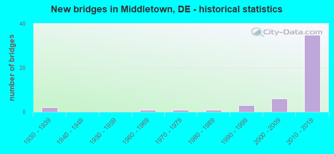
- New bridges - historical statistics
- 21930-1939
- 11960-1969
- 11970-1979
- 11980-1989
- 31990-1999
- 62000-2009
- 352010-2019

- Reconstructed bridges - Historical Statistics
- 11930-1939
- 01940-1949
- 01950-1959
- 01960-1969
- 01970-1979
- 01980-1989
- 11990-1999


- Bridge Condition - Deck
- 3.6%Excellent
- 67.9%Very good
- 28.6%Good

- Bridge Condition - Superstructure
- 3.4%Excellent
- 58.6%Very good
- 34.5%Good
- 3.4%Satisfactory

- Bridge Condition - Substructure
- 37.9%Very good
- 51.7%Good
- 10.3%Satisfactory

- Bridge Condition - Channel
- 57.9%Very good
- 26.3%Good
- 5.3%Satisfactory
- 10.5%Fair

- Bridge Condition - Culverts
- 14.3%Very good
- 42.9%Good
- 28.6%Fair
- 14.3%Serious
Find on map >> Show street view
Structure Number: 1377 435, Location: SOUTH OF SUMMIT BRIDGE (Lat: 39.510033, Lng: -75.752350), Route carried "on" structure: State highway 15, Year Built: 2002, Status: Open, Structure Length: 1.16m (3.81ft), Average Daily Traffic: 7,136 (year 2019), Truck Traffic: 7%, Average Future Daily Traffic: 8,869 (year 2042), Design Load: HL 93, Features Intersected: BACK CREEK, Facility Carried by Structure: CHOPTANK RD.
Minimum Vertical Clearance: 30.48m (100.00ft), Kilometerpoint: 6.310, Lanes on structure: 2, Owner: State Highway Agency, Approaching Roadway Width: 6.7m (22.0ft), Material/Design: Concrete, Design/Construction: Arch - Deck, Number Of Spans In Main Unit: 1, Length of Maximum Span: 11.0m (36.1ft), Curb-To-Curb Width: 12.3m (40.4ft), Out-to-Out Width: 13.2m (43.3ft)
Condition: Superstructure: Good, Substructure: Good, Channel: Very good, Operating Rating: 39.2 metric tons, Method Used To Determine Operating Rating: Load and Resistance Factor Rating (LRFR) rating reported by rating factor(RF) method using HL-93 loadings, Inventory Rating: 30.5 metric tons, Method Used To Determine Inventory Rating: Load and Resistance Factor Rating (LRFR) rating reported by rating factor(RF) method using HL-93 loadings, Structural Evaluation: Better than present minimum criteria, Deck Geometry: Somewhat better than minimum adequacy, Waterway Adequacy: Better than present minimum criteria, Approach Roadway Alignment: Equal to present minimum criteria, Designated Inspection Frequency: Every 24 months, Inspection Date: July 2020, Bridge Improvement Cost: $735,000, Total Project Cost: $735,000, Deck Structure Type: Concrete Cast-file-Place, Wearing Surface/Protective System: Wearing Surface: Monolithic Concrete, Deck Protection: Epoxy Coated Reinforcing
Find on map >> Show street view
Structure Number: 1406 43, Location: NORTH MIDDLETOWN LIMITS (Lat: 39.462439, Lng: -75.687711), Route carried "on" structure: County highway 430, Year Built: 1981, Status: Open, Structure Length: 1.49m (4.89ft), Average Daily Traffic: 4,380 (year 2020), Truck Traffic: 7%, Average Future Daily Traffic: 5,444 (year 2043), Design Load: HS 20, Features Intersected: DOVE NEST BRANCH, Facility Carried by Structure: BRICK MILL RD
Minimum Vertical Clearance: 30.48m (100.00ft), Kilometerpoint: 1.110, Lanes on structure: 2, Owner: State Highway Agency, Approaching Roadway Width: 6.6m (21.7ft), Material/Design: Steel, Design/Construction: Culvert, Number Of Spans In Main Unit: 3, Length of Maximum Span: 4.3m (14.1ft)
Condition: Channel: Satisfactory, Culverts: Serious, Operating Rating: 32.7 metric tons, Method Used To Determine Operating Rating: Field evaluation and documented engineering judgment, Inventory Rating: 32.7 metric tons, Method Used To Determine Inventory Rating: Field evaluation and documented engineering judgment, Structural Evaluation: High priority of corrective action, Waterway Adequacy: Equal to present minimum criteria, Approach Roadway Alignment: Equal to present minimum criteria, Designated Inspection Frequency: Every 6 months, Inspection Date: August 2021
Find on map >> Show street view
Structure Number: 1407 442, Location: S.E. OF MIDDLETOWN (Lat: 39.437892, Lng: -75.693403), Route carried "on" structure: County highway 442, Year Built: 1931, Year Reconstructed: 1939, Status: Open, Structure Length: 0.64m (2.10ft), Average Daily Traffic: 4,821 (year 2020), Truck Traffic: 7%, Average Future Daily Traffic: 5,992 (year 2043), Features Intersected: SILVER LAKE SPILLWY, Facility Carried by Structure: SILVER LAKE RD.
Minimum Vertical Clearance: 30.48m (100.00ft), Kilometerpoint: 0.322, Lanes on structure: 2, Owner: State Highway Agency, Approaching Roadway Width: 5.8m (19.0ft), Material/Design: Steel, Design/Construction: Stringer/Multi-beam, Number Of Spans In Main Unit: 1, Length of Maximum Span: 5.8m (19.0ft), Curb-To-Curb Width: 6.1m (20.0ft), Out-to-Out Width: 6.8m (22.3ft)
Condition: Deck: Good, Superstructure: Very good, Substructure: Satisfactory, Channel: Fair, Operating Rating: 54.4 metric tons, Method Used To Determine Operating Rating: Field evaluation and documented engineering judgment, Inventory Rating: 32.7 metric tons, Method Used To Determine Inventory Rating: Field evaluation and documented engineering judgment, Structural Evaluation: Equal to present minimum criteria, Deck Geometry: High priority of replacement, Waterway Adequacy: Better than present minimum criteria, Approach Roadway Alignment: Equal to present minimum criteria, Length Of Structure Improvement: 0.67m (2.20ft), Designated Inspection Frequency: Every 24 months, Inspection Date: August 2021, Bridge Improvement Cost: $48,000, Roadway Improvement Cost: $5,000, Total Project Cost: $73,000, Deck Structure Type: Concrete Cast-file-Place, Wearing Surface/Protective System: Wearing Surface: Bituminous
Find on map >> Show street view
Structure Number: 1413 432, Location: SOUTH OF SUMMIT BRIDGE (Lat: 39.506028, Lng: -75.746258), Route carried "on" structure: County highway 432, Year Built: 1975, Status: Open, Structure Length: 0.74m (2.43ft), Average Daily Traffic: 1,672 (year 2020), Truck Traffic: 14%, Average Future Daily Traffic: 2,078 (year 2043), Design Load: HS 20, Features Intersected: BACK CREEK, Facility Carried by Structure: CHURCHTOWN RD.
Minimum Vertical Clearance: 30.48m (100.00ft), Kilometerpoint: 3.090, Lanes on structure: 2, Owner: State Highway Agency, Approaching Roadway Width: 6.6m (21.7ft), Material/Design: Aluminum, Iron, Design/Construction: Culvert, Number Of Spans In Main Unit: 2, Length of Maximum Span: 3.1m (10.2ft)
Condition: Channel: Fair, Culverts: Fair, Operating Rating: 54.4 metric tons, Method Used To Determine Operating Rating: Field evaluation and documented engineering judgment, Inventory Rating: 32.7 metric tons, Method Used To Determine Inventory Rating: Field evaluation and documented engineering judgment, Structural Evaluation: Somewhat better than minimum adequacy, Waterway Adequacy: Better than present minimum criteria, Approach Roadway Alignment: Equal to present desirable criteria, Designated Inspection Frequency: Every 24 months, Underwater Inspection Frequency: Every 24 months, Inspection Date: April 2021, Underwater Inspection Date: April 2021
Find on map >> Show street view
Structure Number: 1443 038, Location: S/E MIDDLETOWN LIMITS (Lat: 39.434411, Lng: -75.683058), Route carried "on" structure: County highway 38, Year Built: 1967, Year Reconstructed: 2002, Status: Open, Structure Length: 0.63m (2.07ft), Average Daily Traffic: 2,200 (year 2019), Truck Traffic: 10%, Average Future Daily Traffic: 2,760 (year 2043), Design Load: HS 20, Features Intersected: NOXONTOWN POND/SPILLWAY, Facility Carried by Structure: NOXONTOWN RD.
Minimum Vertical Clearance: 30.48m (100.00ft), Kilometerpoint: 2.800, Lanes on structure: 2, Owner: State Highway Agency, Approaching Roadway Width: 6.7m (22.0ft), Material/Design: Concrete, Design/Construction: Culvert, Number Of Spans In Main Unit: 2, Length of Maximum Span: 3.0m (9.8ft), Curb-To-Curb Width: 9.1m (29.9ft), Out-to-Out Width: 9.8m (32.2ft)
Condition: Channel: Good, Culverts: Fair, Operating Rating: 33.4 metric tons, Method Used To Determine Operating Rating: Load and Resistance Factor Rating (LRFR) rating reported by rating factor(RF) method using HL-93 loadings, Inventory Rating: 26.2 metric tons, Method Used To Determine Inventory Rating: Load and Resistance Factor Rating (LRFR) rating reported by rating factor(RF) method using HL-93 loadings, Structural Evaluation: Somewhat better than minimum adequacy, Deck Geometry: Meets minimum limits, Waterway Adequacy: Better than present minimum criteria, Approach Roadway Alignment: Equal to present desirable criteria, Designated Inspection Frequency: Every 24 months, Inspection Date: March 2021
Find on map >> Show street view
Structure Number: 1444 084, Location: NORTHEAST OF MIDDLETOWN (Lat: 39.509472, Lng: -75.692139), Route carried "on" structure: US 301, Year Built: 2018, Status: Open, Structure Length: 0.77m (2.53ft), Average Daily Traffic: 11,570 (year 2019), Truck Traffic: 9%, Average Future Daily Traffic: 6,830 (year 2040), Design Load: HL 93, Features Intersected: WATERWAY/WILDLIFE X-ING
Minimum Vertical Clearance: 30.48m (100.00ft), Kilometerpoint: 13.148, Lanes on structure: 4, Base Highway Network: Yes, Toll: On toll road, Owner: State Highway Agency, Approaching Roadway Width: 11.4m (37.4ft), Skew: 1 degrees, Material/Design: Concrete, Design/Construction: Culvert, Number Of Spans In Main Unit: 1, Length of Maximum Span: 7.0m (23.0ft)
Condition: Channel: Very good, Culverts: Good, Operating Rating: 44.1 metric tons, Method Used To Determine Operating Rating: Load and Resistance Factor Rating (LRFR) rating reported by rating factor(RF) method using HL-93 loadings, Inventory Rating: 34.0 metric tons, Method Used To Determine Inventory Rating: Load and Resistance Factor Rating (LRFR) rating reported by rating factor(RF) method using HL-93 loadings, Structural Evaluation: Better than present minimum criteria, Waterway Adequacy: Equal to present desirable criteria, Approach Roadway Alignment: Equal to present desirable criteria, Designated Inspection Frequency: Every 24 months, Inspection Date: September 2020
Find on map >> Show street view
Structure Number: 1445 449, Location: S.E. OF ODESSA (Lat: 39.427528, Lng: -75.631833), Route carried "on" structure: State highway 9, Year Built: 1996, Status: Open, Structure Length: 0.67m (2.20ft), Average Daily Traffic: 724 (year 2019), Truck Traffic: 8%, Average Future Daily Traffic: 899 (year 2042), Design Load: HS 20, Features Intersected: HANGMAN RUN
Minimum Vertical Clearance: 30.48m (100.00ft), Kilometerpoint: 13.040, Lanes on structure: 2, Owner: State Highway Agency, Approaching Roadway Width: 7.3m (24.0ft), Material/Design: Concrete, Design/Construction: Culvert, Number Of Spans In Main Unit: 1, Length of Maximum Span: 6.7m (22.0ft), Curb-To-Curb Width: 9.0m (29.5ft), Out-to-Out Width: 9.9m (32.5ft)
Condition: Channel: Very good, Culverts: Good, Operating Rating: 58.6 metric tons, Method Used To Determine Operating Rating: Load and Resistance Factor Rating (LRFR) rating reported by rating factor(RF) method using HL-93 loadings, Inventory Rating: 45.4 metric tons, Method Used To Determine Inventory Rating: Load and Resistance Factor Rating (LRFR) rating reported by rating factor(RF) method using HL-93 loadings, Structural Evaluation: Better than present minimum criteria, Deck Geometry: Somewhat better than minimum adequacy, Waterway Adequacy: Better than present minimum criteria, Approach Roadway Alignment: Equal to present desirable criteria, Designated Inspection Frequency: Every 24 months, Inspection Date: July 2020, Deck Structure Type: Concrete Cast-file-Place, Wearing Surface/Protective System: Wearing Surface: Bituminous
Find on map >> Show street view
Structure Number: 1460N084, Location: WEST OF MIDDLETOWN (Lat: 39.524444, Lng: -75.666250), Route carried "on" structure: US 301, Year Built: 2018, Status: Open, Structure Length: 12.29m (40.32ft), Average Daily Traffic: 5,785 (year 2019), Truck Traffic: 9%, Average Future Daily Traffic: 3,841 (year 2040), Design Load: HL 93, Features Intersected: SCOTT RUN
Minimum Vertical Clearance: 30.48m (100.00ft), Kilometerpoint: 16.544, Lanes on structure: 2, Base Highway Network: Yes, Toll: On toll road, Owner: State Highway Agency, Approaching Roadway Width: 11.6m (38.1ft), Material/Design: Steel continuous, Design/Construction: Stringer/Multi-beam, Number Of Spans In Main Unit: 2, Length of Maximum Span: 68.6m (225.1ft), Curb-To-Curb Width: 12.8m (42.0ft), Out-to-Out Width: 13.7m (44.9ft)
Condition: Deck: Very good, Superstructure: Very good, Substructure: Good, Channel: Good, Operating Rating: 49.9 metric tons, Method Used To Determine Operating Rating: Load and Resistance Factor Rating (LRFR) rating reported by rating factor(RF) method using HL-93 loadings, Inventory Rating: 38.6 metric tons, Method Used To Determine Inventory Rating: Load and Resistance Factor Rating (LRFR) rating reported by rating factor(RF) method using HL-93 loadings, Structural Evaluation: Better than present minimum criteria, Deck Geometry: Equal to present desirable criteria, Waterway Adequacy: Better than present minimum criteria, Approach Roadway Alignment: Equal to present desirable criteria, Designated Inspection Frequency: Every 24 months, Inspection Date: November 2020, Deck Structure Type: Concrete Cast-file-Place, Wearing Surface/Protective System: Wearing Surface: Integral Concrete, Deck Protection: Epoxy Coated Reinforcing
Find on map >> Show street view
Structure Number: 1465, Location: E. OF TOWNSEND (Lat: 39.406381, Lng: -75.644319), Route carried "on" structure: City street , Year Built: 2008, Status: Open, Structure Length: 0.91m (2.99ft), Average Daily Traffic: 99 (year 2019), Truck Traffic: 11%, Average Future Daily Traffic: 123 (year 2042), Design Load: HS 20, Features Intersected: BEAVER BRANCH, Facility Carried by Structure: GLEN MOHR DR.
Minimum Vertical Clearance: 30.48m (100.00ft), Kilometerpoint: 0.322, Lanes on structure: 2, Owner: State Highway Agency, Approaching Roadway Width: 9.8m (32.2ft), Material/Design: Aluminum, Iron, Design/Construction: Culvert, Number Of Spans In Main Unit: 1, Length of Maximum Span: 9.1m (29.9ft), Curb or Sidewalk Widths: Left: 1.5m (4.9ft), Right: 1.5m (4.9ft)
Condition: Channel: Good, Culverts: Good, Operating Rating: 44.7 metric tons, Method Used To Determine Operating Rating: Load Factor (LF), Inventory Rating: 37.8 metric tons, Method Used To Determine Inventory Rating: Load Factor (LF), Structural Evaluation: Better than present minimum criteria, Waterway Adequacy: Better than present minimum criteria, Approach Roadway Alignment: Equal to present desirable criteria, Designated Inspection Frequency: Every 24 months, Inspection Date: August 2020, Deck Structure Type: Closed Grating
Find on map >> Show street view
Structure Number: 1466N084, Location: NORTH OF MIDDLETOWN (Lat: 39.506917, Lng: -75.692806), Route carried "on" structure: US 301, Year Built: 2018, Status: Open, Structure Length: 3.84m (12.60ft), Average Daily Traffic: 5,785 (year 2019), Truck Traffic: 10%, Average Future Daily Traffic: 6,830 (year 2040), Design Load: HL 93, Features Intersected: SR896/BOYDS CORNER RD
Minimum Vertical Clearance: 30.48m (100.00ft), Kilometerpoint: 12.843, Lanes on structure: 2, Lanes under structure: 2, Base Highway Network: Yes, Toll: On toll road, Owner: State Highway Agency, Approaching Roadway Width: 12.8m (42.0ft), Skew: 3 degrees, Material/Design: Prestressed concrete, Design/Construction: Stringer/Multi-beam, Number Of Spans In Main Unit: 1, Length of Maximum Span: 36.6m (120.1ft), Curb-To-Curb Width: 12.8m (42.0ft), Out-to-Out Width: 13.7m (44.9ft)
Condition: Deck: Very good, Superstructure: Very good, Substructure: Very good, Operating Rating: 66.1 metric tons, Method Used To Determine Operating Rating: Load and Resistance Factor Rating (LRFR) rating reported by rating factor(RF) method using HL-93 loadings, Inventory Rating: 51.2 metric tons, Method Used To Determine Inventory Rating: Load and Resistance Factor Rating (LRFR) rating reported by rating factor(RF) method using HL-93 loadings, Structural Evaluation: Equal to present desirable criteria, Deck Geometry: Equal to present desirable criteria, Underclear: Equal to present minimum criteria, Approach Roadway Alignment: Equal to present desirable criteria, Designated Inspection Frequency: Every 24 months, Inspection Date: November 2020, Deck Structure Type: Concrete Cast-file-Place, Wearing Surface/Protective System: Wearing Surface: Monolithic Concrete, Deck Protection: Epoxy Coated Reinforcing
Find on map >> Show street view
Structure Number: 1466S084, Location: NORTH OF MIDDLETOWN (Lat: 39.507111, Lng: -75.693056), Route carried "on" structure: US 301, Year Built: 2018, Status: Open, Structure Length: 3.84m (12.60ft), Average Daily Traffic: 5,785 (year 2019), Truck Traffic: 9%, Average Future Daily Traffic: 6,830 (year 2040), Design Load: HL 93, Features Intersected: SR896/BOYDS CORNER RD
Minimum Vertical Clearance: 30.48m (100.00ft), Kilometerpoint: 25.009, Lanes on structure: 2, Lanes under structure: 2, Base Highway Network: Yes, Toll: On toll road, Owner: State Highway Agency, Approaching Roadway Width: 12.8m (42.0ft), Skew: 3 degrees, Material/Design: Prestressed concrete, Design/Construction: Stringer/Multi-beam, Number Of Spans In Main Unit: 1, Length of Maximum Span: 36.6m (120.1ft), Curb-To-Curb Width: 12.8m (42.0ft), Out-to-Out Width: 13.7m (44.9ft)
Condition: Deck: Good, Superstructure: Very good, Substructure: Very good, Operating Rating: 66.1 metric tons, Method Used To Determine Operating Rating: Load and Resistance Factor Rating (LRFR) rating reported by rating factor(RF) method using HL-93 loadings, Inventory Rating: 51.2 metric tons, Method Used To Determine Inventory Rating: Load and Resistance Factor Rating (LRFR) rating reported by rating factor(RF) method using HL-93 loadings, Structural Evaluation: Equal to present desirable criteria, Deck Geometry: Equal to present desirable criteria, Underclear: Equal to present minimum criteria, Approach Roadway Alignment: Equal to present desirable criteria, Designated Inspection Frequency: Every 24 months, Inspection Date: November 2020, Deck Structure Type: Concrete Cast-file-Place, Wearing Surface/Protective System: Wearing Surface: Monolithic Concrete, Deck Protection: Epoxy Coated Reinforcing
Find on map >> Show street view
Structure Number: 1467N084, Location: NORTH OF MIDDLETOWN (Lat: 39.496361, Lng: -75.702028), Route carried "on" structure: US 301, Year Built: 2018, Status: Open, Structure Length: 4.42m (14.50ft), Average Daily Traffic: 5,785 (year 2019), Truck Traffic: 9%, Average Future Daily Traffic: 6,830 (year 2040), Design Load: HL 93, Features Intersected: DRAWYER CREEK
Minimum Vertical Clearance: 30.48m (100.00ft), Kilometerpoint: 11.362, Lanes on structure: 2, Base Highway Network: Yes, Toll: On toll road, Owner: State Highway Agency, Approaching Roadway Width: 12.8m (42.0ft), Skew: 10 degrees, Material/Design: Prestressed concrete, Design/Construction: Stringer/Multi-beam, Number Of Spans In Main Unit: 1, Length of Maximum Span: 42.7m (140.1ft), Curb-To-Curb Width: 12.8m (42.0ft), Out-to-Out Width: 13.7m (44.9ft)
Condition: Deck: Very good, Superstructure: Very good, Substructure: Very good, Operating Rating: 75.2 metric tons, Method Used To Determine Operating Rating: Load and Resistance Factor Rating (LRFR) rating reported by rating factor(RF) method using HL-93 loadings, Inventory Rating: 54.8 metric tons, Method Used To Determine Inventory Rating: Load and Resistance Factor Rating (LRFR) rating reported by rating factor(RF) method using HL-93 loadings, Structural Evaluation: Equal to present desirable criteria, Deck Geometry: Equal to present desirable criteria, Approach Roadway Alignment: Superior to present desirable criteria, Designated Inspection Frequency: Every 24 months, Inspection Date: November 2020, Deck Structure Type: Concrete Cast-file-Place, Wearing Surface/Protective System: Wearing Surface: Monolithic Concrete, Deck Protection: Epoxy Coated Reinforcing
Find on map >> Show street view
Structure Number: 1467S084, Location: NORTH OF MIDDLETOWN (Lat: 39.496556, Lng: -75.702167), Route carried "on" structure: US 301, Year Built: 2018, Status: Open, Structure Length: 4.42m (14.50ft), Average Daily Traffic: 5,785 (year 2019), Truck Traffic: 9%, Average Future Daily Traffic: 6,830 (year 2040), Design Load: HL 93, Features Intersected: DRAWYER CREEK
Minimum Vertical Clearance: 30.48m (100.00ft), Kilometerpoint: 26.474, Lanes on structure: 2, Base Highway Network: Yes, Toll: On toll road, Owner: State Highway Agency, Approaching Roadway Width: 12.8m (42.0ft), Skew: 10 degrees, Material/Design: Prestressed concrete, Design/Construction: Stringer/Multi-beam, Number Of Spans In Main Unit: 1, Length of Maximum Span: 42.7m (140.1ft), Curb-To-Curb Width: 12.8m (42.0ft), Out-to-Out Width: 13.7m (44.9ft)
Condition: Deck: Excellent, Superstructure: Excellent, Substructure: Very good, Channel: Very good, Operating Rating: 75.2 metric tons, Method Used To Determine Operating Rating: Load and Resistance Factor Rating (LRFR) rating reported by rating factor(RF) method using HL-93 loadings, Inventory Rating: 54.8 metric tons, Method Used To Determine Inventory Rating: Load and Resistance Factor Rating (LRFR) rating reported by rating factor(RF) method using HL-93 loadings, Structural Evaluation: Equal to present desirable criteria, Deck Geometry: Equal to present desirable criteria, Waterway Adequacy: Equal to present desirable criteria, Approach Roadway Alignment: Superior to present desirable criteria, Designated Inspection Frequency: Every 24 months, Inspection Date: November 2020, Deck Structure Type: Concrete Cast-file-Place, Wearing Surface/Protective System: Wearing Surface: Monolithic Concrete, Deck Protection: Epoxy Coated Reinforcing
Find on map >> Show street view
Structure Number: 1468N084, Location: NORTH OF MIDDLETOWN (Lat: 39.489750, Lng: -75.715083), Route carried "on" structure: US 301, Year Built: 2018, Status: Open, Structure Length: 3.33m (10.93ft), Average Daily Traffic: 2,800 (year 2019), Truck Traffic: 20%, Average Future Daily Traffic: 3,415 (year 2040), Design Load: HL 93, Features Intersected: N/S RAILROAD
Minimum Vertical Clearance: 30.48m (100.00ft), Kilometerpoint: 10.026, Lanes on structure: 2, Base Highway Network: Yes, Toll: On toll road, Owner: State Highway Agency, Approaching Roadway Width: 11.6m (38.1ft), Skew: 14 degrees, Material/Design: Prestressed concrete, Design/Construction: Stringer/Multi-beam, Number Of Spans In Main Unit: 1, Length of Maximum Span: 31.4m (103.0ft), Curb-To-Curb Width: 12.8m (42.0ft), Out-to-Out Width: 13.7m (44.9ft)
Condition: Deck: Very good, Superstructure: Very good, Substructure: Good, Operating Rating: 47.3 metric tons, Method Used To Determine Operating Rating: Load and Resistance Factor Rating (LRFR) rating reported by rating factor(RF) method using HL-93 loadings, Inventory Rating: 37.6 metric tons, Method Used To Determine Inventory Rating: Load and Resistance Factor Rating (LRFR) rating reported by rating factor(RF) method using HL-93 loadings, Structural Evaluation: Better than present minimum criteria, Deck Geometry: Equal to present desirable criteria, Underclear: Superior to present desirable criteria, Approach Roadway Alignment: Superior to present desirable criteria, Designated Inspection Frequency: Every 24 months, Inspection Date: November 2020, Deck Structure Type: Concrete Cast-file-Place, Wearing Surface/Protective System: Wearing Surface: Integral Concrete, Deck Protection: Epoxy Coated Reinforcing
Find on map >> Show street view
Structure Number: 1468S084, Location: NORTH OF MIDDLETOWN (Lat: 39.490056, Lng: -75.715028), Route carried "on" structure: US 301, Year Built: 2018, Status: Open, Structure Length: 3.33m (10.93ft), Average Daily Traffic: 2,800 (year 2019), Truck Traffic: 20%, Average Future Daily Traffic: 3,415 (year 2040), Design Load: HL 93, Features Intersected: N/S RAILROAD
Minimum Vertical Clearance: 30.48m (100.00ft), Kilometerpoint: 27.793, Lanes on structure: 2, Base Highway Network: Yes, Toll: On toll road, Owner: State Highway Agency, Approaching Roadway Width: 13.7m (44.9ft), Skew: 14 degrees, Material/Design: Prestressed concrete, Design/Construction: Stringer/Multi-beam, Number Of Spans In Main Unit: 1, Length of Maximum Span: 31.4m (103.0ft), Curb-To-Curb Width: 12.8m (42.0ft), Out-to-Out Width: 13.7m (44.9ft)
Condition: Deck: Very good, Superstructure: Very good, Substructure: Good, Operating Rating: 47.3 metric tons, Method Used To Determine Operating Rating: Load and Resistance Factor Rating (LRFR) rating reported by rating factor(RF) method using HL-93 loadings, Inventory Rating: 37.6 metric tons, Method Used To Determine Inventory Rating: Load and Resistance Factor Rating (LRFR) rating reported by rating factor(RF) method using HL-93 loadings, Structural Evaluation: Better than present minimum criteria, Deck Geometry: Equal to present desirable criteria, Underclear: Superior to present desirable criteria, Approach Roadway Alignment: Equal to present desirable criteria, Designated Inspection Frequency: Every 24 months, Inspection Date: November 2020, Deck Structure Type: Concrete Cast-file-Place, Wearing Surface/Protective System: Wearing Surface: Integral Concrete, Deck Protection: Epoxy Coated Reinforcing
Find on map >> Show street view
Structure Number: 1470N084, Location: NORTH OF MIDDLETOWN (Lat: 39.488583, Lng: -75.717389), Route carried "on" structure: US 301, Year Built: 2018, Status: Open, Structure Length: 6.46m (21.19ft), Average Daily Traffic: 5,785 (year 2019), Truck Traffic: 9%, Average Future Daily Traffic: 3,415 (year 2040), Design Load: HL 93, Features Intersected: SR71/SUMMIT BRIDGE RD
Minimum Vertical Clearance: 30.48m (100.00ft), Kilometerpoint: 9.785, Lanes on structure: 3, Lanes under structure: 4, Base Highway Network: Yes, Toll: On toll road, Owner: State Highway Agency, Approaching Roadway Width: 12.8m (42.0ft), Skew: 13 degrees, Material/Design: Prestressed concrete, Design/Construction: Stringer/Multi-beam, Number Of Spans In Main Unit: 2, Length of Maximum Span: 32.3m (106.0ft), Curb-To-Curb Width: 15.2m (49.9ft), Out-to-Out Width: 16.1m (52.8ft)
Condition: Deck: Good, Superstructure: Good, Substructure: Good, Operating Rating: 47.3 metric tons, Method Used To Determine Operating Rating: Load and Resistance Factor Rating (LRFR) rating reported by rating factor(RF) method using HL-93 loadings, Inventory Rating: 35.6 metric tons, Method Used To Determine Inventory Rating: Load and Resistance Factor Rating (LRFR) rating reported by rating factor(RF) method using HL-93 loadings, Structural Evaluation: Better than present minimum criteria, Deck Geometry: Equal to present minimum criteria, Underclear: Meets minimum limits, Approach Roadway Alignment: Equal to present desirable criteria, Designated Inspection Frequency: Every 24 months, Inspection Date: November 2020, Deck Structure Type: Concrete Cast-file-Place, Wearing Surface/Protective System: Wearing Surface: Integral Concrete, Deck Protection: Epoxy Coated Reinforcing
Find on map >> Show street view
Structure Number: 1470S084, Location: NORTH OF MIDDLETOWN (Lat: 39.488944, Lng: -75.717222), Route carried "on" structure: US 301, Year Built: 2018, Status: Open, Structure Length: 6.46m (21.19ft), Average Daily Traffic: 5,785 (year 2019), Truck Traffic: 9%, Average Future Daily Traffic: 3,415 (year 2040), Design Load: HL 93, Features Intersected: SUMMIT BRIDGE RD
Minimum Vertical Clearance: 30.48m (100.00ft), Kilometerpoint: 28.019, Lanes on structure: 2, Lanes under structure: 4, Base Highway Network: Yes, Toll: On toll road, Owner: State Highway Agency, Approaching Roadway Width: 12.8m (42.0ft), Skew: 3 degrees, Material/Design: Prestressed concrete, Design/Construction: Stringer/Multi-beam, Number Of Spans In Main Unit: 2, Length of Maximum Span: 32.3m (106.0ft), Curb-To-Curb Width: 12.8m (42.0ft), Out-to-Out Width: 13.7m (44.9ft)
Condition: Deck: Very good, Superstructure: Good, Substructure: Good, Operating Rating: 44.4 metric tons, Method Used To Determine Operating Rating: Load and Resistance Factor Rating (LRFR) rating reported by rating factor(RF) method using HL-93 loadings, Inventory Rating: 33.7 metric tons, Method Used To Determine Inventory Rating: Load and Resistance Factor Rating (LRFR) rating reported by rating factor(RF) method using HL-93 loadings, Structural Evaluation: Better than present minimum criteria, Deck Geometry: Equal to present desirable criteria, Underclear: Superior to present desirable criteria, Approach Roadway Alignment: Equal to present desirable criteria, Designated Inspection Frequency: Every 24 months, Inspection Date: November 2020, Deck Structure Type: Concrete Cast-file-Place, Wearing Surface/Protective System: Wearing Surface: Integral Concrete, Deck Protection: Epoxy Coated Reinforcing
Find on map >> Show street view
Structure Number: 1472N084, Location: North of Middletown (Lat: 39.480583, Lng: -75.723944), Route carried "on" structure: US 301, Year Built: 2018, Status: Open, Structure Length: 2.85m (9.35ft), Average Daily Traffic: 5,785 (year 2019), Truck Traffic: 9%, Average Future Daily Traffic: 4,817 (year 2040), Design Load: HL 93, Features Intersected: ARMSTRONG CORNER RD
Minimum Vertical Clearance: 30.48m (100.00ft), Kilometerpoint: 8.707, Lanes on structure: 3, Lanes under structure: 2, Base Highway Network: Yes, Toll: On toll road, Owner: State Highway Agency, Approaching Roadway Width: 11.6m (38.1ft), Skew: 2 degrees, Material/Design: Prestressed concrete, Design/Construction: Stringer/Multi-beam, Number Of Spans In Main Unit: 1, Length of Maximum Span: 27.6m (90.6ft), Curb-To-Curb Width: 15.2m (49.9ft), Out-to-Out Width: 16.1m (52.8ft)
Condition: Deck: Very good, Superstructure: Good, Substructure: Very good, Operating Rating: 41.5 metric tons, Method Used To Determine Operating Rating: Load and Resistance Factor Rating (LRFR) rating reported by rating factor(RF) method using HL-93 loadings, Inventory Rating: 33.0 metric tons, Method Used To Determine Inventory Rating: Load and Resistance Factor Rating (LRFR) rating reported by rating factor(RF) method using HL-93 loadings, Structural Evaluation: Better than present minimum criteria, Deck Geometry: Equal to present minimum criteria, Underclear: Equal to present minimum criteria, Approach Roadway Alignment: Equal to present desirable criteria, Designated Inspection Frequency: Every 24 months, Inspection Date: October 2020, Deck Structure Type: Concrete Cast-file-Place, Wearing Surface/Protective System: Wearing Surface: Monolithic Concrete, Deck Protection: Epoxy Coated Reinforcing
Find on map >> Show street view
Structure Number: 1472S084, Location: N OF MIDDLETOWN (Lat: 39.480611, Lng: -75.724306), Route carried "on" structure: US 301, Year Built: 2018, Status: Open, Structure Length: 2.85m (9.35ft), Average Daily Traffic: 5,785 (year 2019), Truck Traffic: 9%, Average Future Daily Traffic: 50,189 (year 2040), Design Load: HL 93, Features Intersected: ARMSTRONG CORNER RD
Minimum Vertical Clearance: 30.48m (100.00ft), Kilometerpoint: 29.161, Lanes on structure: 2, Lanes under structure: 2, Base Highway Network: Yes, Toll: On toll road, Owner: State Highway Agency, Approaching Roadway Width: 11.6m (38.1ft), Skew: 2 degrees, Material/Design: Prestressed concrete, Design/Construction: Stringer/Multi-beam, Number Of Spans In Main Unit: 1, Length of Maximum Span: 27.6m (90.6ft), Curb-To-Curb Width: 15.2m (49.9ft), Out-to-Out Width: 16.1m (52.8ft)
Condition: Deck: Very good, Superstructure: Very good, Substructure: Good, Operating Rating: 41.5 metric tons, Method Used To Determine Operating Rating: Load and Resistance Factor Rating (LRFR) rating reported by rating factor(RF) method using HL-93 loadings, Inventory Rating: 33.0 metric tons, Method Used To Determine Inventory Rating: Load and Resistance Factor Rating (LRFR) rating reported by rating factor(RF) method using HL-93 loadings, Structural Evaluation: Better than present minimum criteria, Deck Geometry: Superior to present desirable criteria, Underclear: Better than present minimum criteria, Approach Roadway Alignment: Equal to present desirable criteria, Designated Inspection Frequency: Every 24 months, Inspection Date: October 2020, Deck Structure Type: Concrete Cast-file-Place, Wearing Surface/Protective System: Wearing Surface: Monolithic Concrete, Deck Protection: Epoxy Coated Reinforcing
Find on map >> Show street view
Structure Number: 1475 437, Location: NORTHWEST OF MIDDLETOWN (Lat: 39.456472, Lng: -75.741500), Route carried "on" structure: City street 15, Year Built: 2017, Status: Open, Structure Length: 4.64m (15.22ft), Average Daily Traffic: 2,310 (year 2019), Truck Traffic: 10%, Average Future Daily Traffic: 2,587 (year 2040), Design Load: HL 93, Features Intersected: US 301, Facility Carried by Structure: BUNKER HILL RD
Minimum Vertical Clearance: 30.48m (100.00ft), Kilometerpoint: 2.784, Lanes on structure: 2, Lanes under structure: 4, Owner: State Highway Agency, Approaching Roadway Width: 10.3m (33.8ft), Skew: 1 degrees, Material/Design: Prestressed concrete, Design/Construction: Stringer/Multi-beam, Number Of Spans In Main Unit: 2, Length of Maximum Span: 22.3m (73.2ft), Curb or Sidewalk Widths: Left: 1.8m (5.9ft), Right: 0.0m, Curb-To-Curb Width: 10.4m (34.1ft), Out-to-Out Width: 12.8m (42.0ft)
Condition: Deck: Very good, Superstructure: Very good, Substructure: Very good, Operating Rating: 40.8 metric tons, Method Used To Determine Operating Rating: Load and Resistance Factor Rating (LRFR) rating reported by rating factor(RF) method using HL-93 loadings, Inventory Rating: 32.7 metric tons, Method Used To Determine Inventory Rating: Load and Resistance Factor Rating (LRFR) rating reported by rating factor(RF) method using HL-93 loadings, Structural Evaluation: Equal to present desirable criteria, Deck Geometry: Somewhat better than minimum adequacy, Underclear: Equal to present minimum criteria, Approach Roadway Alignment: Equal to present minimum criteria, Designated Inspection Frequency: Every 24 months, Inspection Date: May 2020, Deck Structure Type: Concrete Cast-file-Place, Wearing Surface/Protective System: Wearing Surface: Monolithic Concrete, Deck Protection: Epoxy Coated Reinforcing
Find on map >> Show street view
Structure Number: 1477N084, Location: WEST OF MIDDLETOWN (Lat: 39.448694, Lng: -75.748028), Route carried "on" structure: US 301, Year Built: 2018, Status: Open, Structure Length: 6.16m (20.21ft), Average Daily Traffic: 5,785 (year 2019), Truck Traffic: 9%, Average Future Daily Traffic: 3,232 (year 2040), Design Load: HL 93, Features Intersected: TRIB TO SANDY BRANCH
Minimum Vertical Clearance: 30.48m (100.00ft), Kilometerpoint: 4.538, Lanes on structure: 3, Base Highway Network: Yes, Toll: On toll road, Owner: State Highway Agency, Approaching Roadway Width: 11.6m (38.1ft), Skew: 3 degrees, Material/Design: Prestressed concrete, Design/Construction: Stringer/Multi-beam, Number Of Spans In Main Unit: 2, Length of Maximum Span: 33.5m (109.9ft), Curb-To-Curb Width: 16.1m (52.8ft), Out-to-Out Width: 16.1m (52.8ft)
Condition: Deck: Very good, Superstructure: Very good, Substructure: Good, Channel: Very good, Operating Rating: 47.6 metric tons, Method Used To Determine Operating Rating: Load and Resistance Factor Rating (LRFR) rating reported by rating factor(RF) method using HL-93 loadings, Inventory Rating: 37.9 metric tons, Method Used To Determine Inventory Rating: Load and Resistance Factor Rating (LRFR) rating reported by rating factor(RF) method using HL-93 loadings, Structural Evaluation: Better than present minimum criteria, Deck Geometry: Better than present minimum criteria, Waterway Adequacy: Equal to present desirable criteria, Approach Roadway Alignment: Equal to present desirable criteria, Designated Inspection Frequency: Every 24 months, Inspection Date: October 2020, Deck Structure Type: Concrete Cast-file-Place, Wearing Surface/Protective System: Wearing Surface: Integral Concrete, Deck Protection: Epoxy Coated Reinforcing
Find on map >> Show street view
Structure Number: 1477S084, Location: WEST OF MIDDLETOWN (Lat: 39.448611, Lng: -75.748500), Route carried "on" structure: US 301, Year Built: 2018, Status: Open, Structure Length: 4.61m (15.12ft), Average Daily Traffic: 5,785 (year 2019), Truck Traffic: 9%, Average Future Daily Traffic: 3,232 (year 2040), Design Load: HL 93, Features Intersected: TRIB TO SANDY BRANCH
Minimum Vertical Clearance: 30.48m (100.00ft), Kilometerpoint: 33.346, Lanes on structure: 3, Base Highway Network: Yes, Toll: On toll road, Owner: State Highway Agency, Approaching Roadway Width: 12.8m (42.0ft), Skew: 3 degrees, Material/Design: Prestressed concrete, Design/Construction: Stringer/Multi-beam, Number Of Spans In Main Unit: 1, Length of Maximum Span: 44.2m (145.0ft), Curb-To-Curb Width: 15.2m (49.9ft), Out-to-Out Width: 16.1m (52.8ft)
Condition: Deck: Very good, Superstructure: Good, Substructure: Good, Channel: Very good, Operating Rating: 54.4 metric tons, Method Used To Determine Operating Rating: Load and Resistance Factor Rating (LRFR) rating reported by rating factor(RF) method using HL-93 loadings, Inventory Rating: 41.5 metric tons, Method Used To Determine Inventory Rating: Load and Resistance Factor Rating (LRFR) rating reported by rating factor(RF) method using HL-93 loadings, Structural Evaluation: Better than present minimum criteria, Deck Geometry: Equal to present minimum criteria, Waterway Adequacy: Equal to present desirable criteria, Approach Roadway Alignment: Equal to present desirable criteria, Designated Inspection Frequency: Every 24 months, Inspection Date: October 2020, Deck Structure Type: Concrete Cast-file-Place, Wearing Surface/Protective System: Wearing Surface: Integral Concrete, Deck Protection: Epoxy Coated Reinforcing
Find on map >> Show street view
Structure Number: 1479 6617, Location: WEST OF MIDDLETOWN (Lat: 39.447250, Lng: -75.750528), Route carried "on" structure: US 301, Year Built: 2018, Status: Open, Structure Length: 4.27m (14.01ft), Average Daily Traffic: 650 (year 2019), Truck Traffic: 18%, Average Future Daily Traffic: 792 (year 2040), Design Load: HL 93, Features Intersected: SANDY BRANCH
Minimum Vertical Clearance: 30.48m (100.00ft), Kilometerpoint: 0.161, Lanes on structure: 2, Base Highway Network: Yes, Toll: On toll road, Owner: State Highway Agency, Approaching Roadway Width: 11.7m (38.4ft), Skew: 1 degrees, Material/Design: Prestressed concrete, Design/Construction: Stringer/Multi-beam, Number Of Spans In Main Unit: 1, Length of Maximum Span: 41.1m (134.8ft), Curb-To-Curb Width: 13.0m (42.7ft), Out-to-Out Width: 13.8m (45.3ft)
Condition: Deck: Very good, Superstructure: Very good, Substructure: Very good, Channel: Very good, Operating Rating: 59.9 metric tons, Method Used To Determine Operating Rating: Load and Resistance Factor Rating (LRFR) rating reported by rating factor(RF) method using HL-93 loadings, Inventory Rating: 40.5 metric tons, Method Used To Determine Inventory Rating: Load and Resistance Factor Rating (LRFR) rating reported by rating factor(RF) method using HL-93 loadings, Structural Evaluation: Equal to present desirable criteria, Deck Geometry: Superior to present desirable criteria, Waterway Adequacy: Equal to present desirable criteria, Approach Roadway Alignment: Equal to present desirable criteria, Designated Inspection Frequency: Every 24 months, Inspection Date: October 2020, Deck Structure Type: Concrete Cast-file-Place, Wearing Surface/Protective System: Wearing Surface: Integral Concrete, Deck Protection: Epoxy Coated Reinforcing
Find on map >> Show street view
Structure Number: 1480N084, Location: WEST OF MIDDLETOWN (Lat: 39.446417, Lng: -75.750222), Route carried "on" structure: US 301, Year Built: 2018, Status: Open, Structure Length: 7.62m (25.00ft), Average Daily Traffic: 5,785 (year 2019), Truck Traffic: 9%, Average Future Daily Traffic: 3,232 (year 2040), Design Load: HL 93, Features Intersected: SANDY BRANCH
Minimum Vertical Clearance: 30.48m (100.00ft), Kilometerpoint: 4.216, Lanes on structure: 2, Base Highway Network: Yes, Toll: On toll road, Owner: State Highway Agency, Approaching Roadway Width: 11.6m (38.1ft), Skew: 3 degrees, Material/Design: Prestressed concrete, Design/Construction: Stringer/Multi-beam, Number Of Spans In Main Unit: 2, Length of Maximum Span: 39.6m (129.9ft), Curb-To-Curb Width: 12.8m (42.0ft), Out-to-Out Width: 13.7m (44.9ft)
Condition: Deck: Very good, Superstructure: Very good, Substructure: Very good, Channel: Very good, Operating Rating: 58.6 metric tons, Method Used To Determine Operating Rating: Load and Resistance Factor Rating (LRFR) rating reported by rating factor(RF) method using HL-93 loadings, Inventory Rating: 44.4 metric tons, Method Used To Determine Inventory Rating: Load and Resistance Factor Rating (LRFR) rating reported by rating factor(RF) method using HL-93 loadings, Structural Evaluation: Equal to present desirable criteria, Deck Geometry: Equal to present desirable criteria, Waterway Adequacy: Equal to present desirable criteria, Approach Roadway Alignment: Equal to present desirable criteria, Designated Inspection Frequency: Every 24 months, Inspection Date: October 2020, Deck Structure Type: Concrete Cast-file-Place, Wearing Surface/Protective System: Wearing Surface: Integral Concrete, Deck Protection: Epoxy Coated Reinforcing
Find on map >> Show street view
Structure Number: 1480S084, Location: WEST OF MIDDLETOWN (Lat: 39.446722, Lng: -75.750361), Route carried "on" structure: US 301, Year Built: 2018, Status: Open, Structure Length: 6.10m (20.01ft), Average Daily Traffic: 5,785 (year 2019), Truck Traffic: 9%, Average Future Daily Traffic: 3,232 (year 2040), Design Load: HL 93, Features Intersected: SANDY BRANCH
Minimum Vertical Clearance: 30.48m (100.00ft), Kilometerpoint: 33.619, Lanes on structure: 2, Base Highway Network: Yes, Toll: On toll road, Owner: State Highway Agency, Approaching Roadway Width: 11.6m (38.1ft), Skew: 3 degrees, Material/Design: Prestressed concrete, Design/Construction: Stringer/Multi-beam, Number Of Spans In Main Unit: 2, Length of Maximum Span: 36.6m (120.1ft), Curb-To-Curb Width: 12.8m (42.0ft), Out-to-Out Width: 13.7m (44.9ft)
Condition: Deck: Very good, Superstructure: Very good, Substructure: Good, Channel: Very good, Operating Rating: 58.6 metric tons, Method Used To Determine Operating Rating: Load and Resistance Factor Rating (LRFR) rating reported by rating factor(RF) method using HL-93 loadings, Inventory Rating: 44.4 metric tons, Method Used To Determine Inventory Rating: Load and Resistance Factor Rating (LRFR) rating reported by rating factor(RF) method using HL-93 loadings, Structural Evaluation: Better than present minimum criteria, Deck Geometry: Equal to present desirable criteria, Waterway Adequacy: Equal to present desirable criteria, Approach Roadway Alignment: Equal to present desirable criteria, Designated Inspection Frequency: Every 24 months, Inspection Date: October 2020, Deck Structure Type: Concrete Cast-file-Place, Wearing Surface/Protective System: Wearing Surface: Integral Concrete, Deck Protection: Epoxy Coated Reinforcing
Find on map >> Show street view
Structure Number: 1482 01, Location: SOUTHWEST OF MIDDLETOWN (Lat: 39.444944, Lng: -75.751833), Route carried "on" structure: State highway 299, Year Built: 2018, Status: Open, Structure Length: 4.47m (14.67ft), Average Daily Traffic: 16,015 (year 2019), Truck Traffic: 8%, Average Future Daily Traffic: 20,246 (year 2040), Design Load: HL 93, Features Intersected: US301
Minimum Vertical Clearance: 30.48m (100.00ft), Kilometerpoint: 7.097, Lanes on structure: 4, Lanes under structure: 4, Owner: State Highway Agency, Approaching Roadway Width: 23.2m (76.1ft), Skew: 10 degrees, Material/Design: Prestressed concrete, Design/Construction: Stringer/Multi-beam, Number Of Spans In Main Unit: 2, Length of Maximum Span: 21.9m (71.9ft), Curb-To-Curb Width: 23.2m (76.1ft), Out-to-Out Width: 24.1m (79.1ft)
Condition: Deck: Very good, Superstructure: Very good, Substructure: Very good, Operating Rating: 66.7 metric tons, Method Used To Determine Operating Rating: Load and Resistance Factor Rating (LRFR) rating reported by rating factor(RF) method using HL-93 loadings, Inventory Rating: 49.2 metric tons, Method Used To Determine Inventory Rating: Load and Resistance Factor Rating (LRFR) rating reported by rating factor(RF) method using HL-93 loadings, Structural Evaluation: Equal to present desirable criteria, Deck Geometry: Superior to present desirable criteria, Underclear: High priority of corrective action, Approach Roadway Alignment: Equal to present desirable criteria, Designated Inspection Frequency: Every 24 months, Inspection Date: May 2020, Deck Structure Type: Concrete Cast-file-Place, Wearing Surface/Protective System: Wearing Surface: Monolithic Concrete, Deck Protection: Epoxy Coated Reinforcing
Find on map >> Show street view
Structure Number: 1486 445, Location: SOUTHWEST OF MIDDLETOWN (Lat: 39.415111, Lng: -75.766722), Route carried "on" structure: State highway 445, Year Built: 2018, Status: Open, Structure Length: 4.51m (14.80ft), Average Daily Traffic: 682 (year 2019), Truck Traffic: 10%, Average Future Daily Traffic: 814 (year 2040), Design Load: HL 93, Features Intersected: US 301, Facility Carried by Structure: STRAWBERRY LANE
Minimum Vertical Clearance: 30.48m (100.00ft), Kilometerpoint: 1.625, Lanes on structure: 2, Lanes under structure: 4, Owner: State Highway Agency, Approaching Roadway Width: 11.1m (36.4ft), Skew: 1 degrees, Material/Design: Prestressed concrete, Design/Construction: Stringer/Multi-beam, Number Of Spans In Main Unit: 2, Length of Maximum Span: 21.9m (71.9ft), Curb-To-Curb Width: 11.0m (36.1ft), Out-to-Out Width: 11.9m (39.0ft)
Condition: Deck: Very good, Superstructure: Very good, Substructure: Very good, Operating Rating: 61.2 metric tons, Method Used To Determine Operating Rating: Load and Resistance Factor Rating (LRFR) rating reported by rating factor(RF) method using HL-93 loadings, Inventory Rating: 45.4 metric tons, Method Used To Determine Inventory Rating: Load and Resistance Factor Rating (LRFR) rating reported by rating factor(RF) method using HL-93 loadings, Structural Evaluation: Equal to present desirable criteria, Deck Geometry: Better than present minimum criteria, Underclear: Equal to present minimum criteria, Approach Roadway Alignment: Equal to present desirable criteria, Designated Inspection Frequency: Every 24 months, Inspection Date: May 2020, Deck Structure Type: Concrete Cast-file-Place, Wearing Surface/Protective System: Wearing Surface: Monolithic Concrete, Deck Protection: Epoxy Coated Reinforcing
Find on map >> Show street view
Structure Number: 1503 447, Location: SOUTH OF MIDDLETOWN (Lat: 39.432903, Lng: -75.716917), Route carried "on" structure: County highway 447, Year Built: 2010, Status: Open, Structure Length: 2.38m (7.81ft), Average Daily Traffic: 3,425 (year 2019), Truck Traffic: 9%, Average Future Daily Traffic: 3,706 (year 2038), Design Load: HS 20+Mod, Features Intersected: NORFOLK SOUTHERN, Facility Carried by Structure: ST. ANNS CHURCH RD
Minimum Vertical Clearance: 30.48m (100.00ft), Kilometerpoint: 0.483, Lanes on structure: 2, Owner: State Highway Agency, Approaching Roadway Width: 6.7m (22.0ft), Skew: 2 degrees, Material/Design: Steel, Design/Construction: Stringer/Multi-beam, Number Of Spans In Main Unit: 1, Length of Maximum Span: 23.2m (76.1ft), Curb or Sidewalk Widths: Left: 1.5m (4.9ft), Right: 1.5m (4.9ft), Curb-To-Curb Width: 11.0m (36.1ft), Out-to-Out Width: 15.6m (51.2ft)
Condition: Deck: Very good, Superstructure: Good, Substructure: Good, Operating Rating: 66.4 metric tons, Method Used To Determine Operating Rating: Load and Resistance Factor Rating (LRFR) rating reported by rating factor(RF) method using HL-93 loadings, Inventory Rating: 51.2 metric tons, Method Used To Determine Inventory Rating: Load and Resistance Factor Rating (LRFR) rating reported by rating factor(RF) method using HL-93 loadings, Structural Evaluation: Better than present minimum criteria, Deck Geometry: Somewhat better than minimum adequacy, Underclear: Superior to present desirable criteria, Approach Roadway Alignment: Equal to present desirable criteria, Length Of Structure Improvement: 2.93m (9.61ft), Designated Inspection Frequency: Every 24 months, Inspection Date: June 2020, Bridge Improvement Cost: $209,000, Roadway Improvement Cost: $21,000, Total Project Cost: $314,000, Deck Structure Type: Concrete Cast-file-Place, Wearing Surface/Protective System: Wearing Surface: Monolithic Concrete, Deck Protection: Epoxy Coated Reinforcing
Find on map >> Show street view
Structure Number: 1504 442, Location: S.E. OF MIDDLETOWN (Lat: 39.438058, Lng: -75.693331), Route carried "on" structure: County highway 442, Year Built: 1939, Status: Open, Structure Length: 0.78m (2.56ft), Average Daily Traffic: 4,821 (year 2020), Truck Traffic: 7%, Average Future Daily Traffic: 5,992 (year 2043), Design Load: H 20, Features Intersected: SILVER LAKE SPILLWAY, Facility Carried by Structure: SILVER LAKE RD.
Minimum Vertical Clearance: 30.48m (100.00ft), Kilometerpoint: 0.322, Lanes on structure: 2, Owner: State Highway Agency, Approaching Roadway Width: 6.5m (21.3ft), Material/Design: Concrete, Design/Construction: Slab, Number Of Spans In Main Unit: 2, Length of Maximum Span: 3.7m (12.1ft), Curb-To-Curb Width: 7.5m (24.6ft), Out-to-Out Width: 8.2m (26.9ft)
Condition: Deck: Very good, Superstructure: Very good, Substructure: Good, Channel: Good, Operating Rating: 50.5 metric tons, Method Used To Determine Operating Rating: Load Factor (LF), Inventory Rating: 30.3 metric tons, Method Used To Determine Inventory Rating: Load Factor (LF), Structural Evaluation: Better than present minimum criteria, Deck Geometry: High priority of replacement, Waterway Adequacy: Better than present minimum criteria, Approach Roadway Alignment: Equal to present minimum criteria, Designated Inspection Frequency: Every 24 months, Inspection Date: August 2021, Deck Structure Type: Concrete Cast-file-Place, Wearing Surface/Protective System: Wearing Surface: Bituminous
Find on map >> Show street view
Structure Number: 1507N084, Location: NORTH OF MIDDLETOWN (Lat: 39.484167, Lng: -75.721750), Route carried "on" structure: Interstate 301, Year Built: 2018, Status: Open, Structure Length: 3.62m (11.88ft), Average Daily Traffic: 5,785 (year 2019), Truck Traffic: 9%, Average Future Daily Traffic: 2,408 (year 2040), Design Load: HL 93, Features Intersected: CONNECTOR RD
Minimum Vertical Clearance: 30.48m (100.00ft), Kilometerpoint: 9.141, Lanes on structure: 2, Lanes under structure: 2, Base Highway Network: Yes, Toll: On toll road, Owner: State Highway Agency, Approaching Roadway Width: 12.2m (40.0ft), Skew: 10 degrees, Material/Design: Prestressed concrete, Design/Construction: Stringer/Multi-beam, Number Of Spans In Main Unit: 1, Length of Maximum Span: 35.7m (117.1ft), Curb-To-Curb Width: 12.2m (40.0ft), Out-to-Out Width: 13.7m (44.9ft)
Condition: Deck: Very good, Superstructure: Good, Substructure: Good, Operating Rating: 47.3 metric tons, Method Used To Determine Operating Rating: Load and Resistance Factor Rating (LRFR) rating reported by rating factor(RF) method using HL-93 loadings, Inventory Rating: 37.6 metric tons, Method Used To Determine Inventory Rating: Load and Resistance Factor Rating (LRFR) rating reported by rating factor(RF) method using HL-93 loadings, Structural Evaluation: Better than present minimum criteria, Deck Geometry: Better than present minimum criteria, Underclear: High priority of corrective action, Approach Roadway Alignment: Equal to present desirable criteria, Designated Inspection Frequency: Every 24 months, Inspection Date: October 2020, Deck Structure Type: Concrete Cast-file-Place, Wearing Surface/Protective System: Wearing Surface: Integral Concrete, Deck Protection: Epoxy Coated Reinforcing
Find on map >> Show street view
Structure Number: 1507S084, Location: NORTH OF MIDDLETOWN (Lat: 39.484278, Lng: -75.722000), Route carried "on" structure: Interstate 301, Year Built: 2018, Status: Open, Structure Length: 3.63m (11.91ft), Average Daily Traffic: 5,785 (year 2019), Truck Traffic: 9%, Average Future Daily Traffic: 35,090 (year 2040), Design Load: HL 93, Features Intersected: CONNECTOR RD
Minimum Vertical Clearance: 30.48m (100.00ft), Kilometerpoint: 28.711, Lanes on structure: 2, Lanes under structure: 2, Base Highway Network: Yes, Toll: On toll road, Owner: State Highway Agency, Approaching Roadway Width: 11.6m (38.1ft), Skew: 10 degrees, Material/Design: Prestressed concrete, Design/Construction: Stringer/Multi-beam, Number Of Spans In Main Unit: 1, Length of Maximum Span: 35.7m (117.1ft), Curb-To-Curb Width: 12.8m (42.0ft), Out-to-Out Width: 13.7m (44.9ft)
Condition: Deck: Good, Superstructure: Very good, Substructure: Very good, Operating Rating: 47.3 metric tons, Method Used To Determine Operating Rating: Load and Resistance Factor Rating (LRFR) rating reported by rating factor(RF) method using HL-93 loadings, Inventory Rating: 37.6 metric tons, Method Used To Determine Inventory Rating: Load and Resistance Factor Rating (LRFR) rating reported by rating factor(RF) method using HL-93 loadings, Structural Evaluation: Equal to present desirable criteria, Deck Geometry: Equal to present desirable criteria, Underclear: High priority of corrective action, Approach Roadway Alignment: Equal to present desirable criteria, Designated Inspection Frequency: Every 24 months, Inspection Date: October 2020, Deck Structure Type: Concrete Cast-file-Place, Wearing Surface/Protective System: Wearing Surface: Integral Concrete, Deck Protection: Epoxy Coated Reinforcing
Find on map >> Show street view
Structure Number: 1508B6611, Location: WEST OF MIDDLETOWN (Lat: 39.445472, Lng: -75.749444), Route carried "on" structure: Ramp US 301, Year Built: 2018, Status: Open, Structure Length: 1.28m (4.20ft), Average Daily Traffic: 1,300 (year 2019), Truck Traffic: 15%, Average Future Daily Traffic: 1,585 (year 2040), Design Load: HL 93, Features Intersected: SANDY BRANCH
Minimum Vertical Clearance: 30.48m (100.00ft), Kilometerpoint: 0.161, Lanes on structure: 2, Base Highway Network: Yes, Toll: On toll road, Owner: State Highway Agency, Approaching Roadway Width: 14.6m (47.9ft), Material/Design: Concrete, Design/Construction: Culvert, Number Of Spans In Main Unit: 1, Length of Maximum Span: 12.2m (40.0ft)
Condition: Channel: Very good, Culverts: Very good, Operating Rating: 71.3 metric tons, Method Used To Determine Operating Rating: Load and Resistance Factor Rating (LRFR) rating reported by rating factor(RF) method using HL-93 loadings, Inventory Rating: 64.8 metric tons, Method Used To Determine Inventory Rating: Load and Resistance Factor Rating (LRFR) rating reported by rating factor(RF) method using HL-93 loadings, Structural Evaluation: Equal to present desirable criteria, Waterway Adequacy: Equal to present desirable criteria, Approach Roadway Alignment: Equal to present desirable criteria, Designated Inspection Frequency: Every 24 months, Inspection Date: October 2020
Find on map >> Show street view
Structure Number: 1906N083, Location: SOUTH OF ODESSA (Lat: 39.442467, Lng: -75.664503), Route carried "on" structure: State highway 1, Year Built: 1999, Status: Open, Structure Length: 26.55m (87.11ft), Average Daily Traffic: 23,428 (year 2019), Truck Traffic: 9%, Average Future Daily Traffic: 29,395 (year 2043), Design Load: HS 25 or greater, Features Intersected: APPOQUINIMINK RIVER, Facility Carried by Structure: KOREAN WAR VET HWY
Minimum Vertical Clearance: 30.48m (100.00ft), Kilometerpoint: 1.593, Lanes on structure: 2, Base Highway Network: Yes, Toll: On toll road, Owner: State Highway Agency, Approaching Roadway Width: 12.5m (41.0ft), Material/Design: Prestressed concrete, Design/Construction: Stringer/Multi-beam, Number Of Spans In Main Unit: 1, Number Of Approach Spans: 12, Length of Maximum Span: 38.1m (125.0ft), Curb-To-Curb Width: 12.8m (42.0ft), Out-to-Out Width: 13.6m (44.6ft)
Condition: Deck: Good, Superstructure: Good, Substructure: Satisfactory, Channel: Good, Operating Rating: 47.0 metric tons, Method Used To Determine Operating Rating: Load and Resistance Factor Rating (LRFR) rating reported by rating factor(RF) method using HL-93 loadings, Inventory Rating: 32.4 metric tons, Method Used To Determine Inventory Rating: Load and Resistance Factor Rating (LRFR) rating reported by rating factor(RF) method using HL-93 loadings, Structural Evaluation: Equal to present minimum criteria, Deck Geometry: Equal to present desirable criteria, Waterway Adequacy: Equal to present minimum criteria, Approach Roadway Alignment: Equal to present desirable criteria, Designated Inspection Frequency: Every 24 months, Inspection Date: April 2021, Deck Structure Type: Concrete Cast-file-Place, Wearing Surface/Protective System: Wearing Surface: Monolithic Concrete, Deck Protection: Epoxy Coated Reinforcing
Find on map >> Show street view
Structure Number: 1906S083, Location: SOUTH OF ODESSA (Lat: 39.442275, Lng: -75.664750), Route carried "on" structure: State highway 1, Year Built: 1999, Status: Open, Structure Length: 28.33m (92.95ft), Average Daily Traffic: 18,626 (year 2020), Truck Traffic: 10%, Average Future Daily Traffic: 23,150 (year 2043), Design Load: HS 25 or greater, Features Intersected: APPOQUINIMINK RIVER, Facility Carried by Structure: KOREAN WAR VET MEM
Minimum Vertical Clearance: 30.48m (100.00ft), Kilometerpoint: 26.651, Lanes on structure: 2, Base Highway Network: Yes, Toll: On toll road, Owner: State Highway Agency, Approaching Roadway Width: 12.5m (41.0ft), Material/Design: Prestressed concrete, Design/Construction: Stringer/Multi-beam, Number Of Spans In Main Unit: 1, Number Of Approach Spans: 13, Length of Maximum Span: 38.1m (125.0ft), Curb-To-Curb Width: 12.8m (42.0ft), Out-to-Out Width: 13.6m (44.6ft)
Condition: Deck: Good, Superstructure: Good, Substructure: Satisfactory, Channel: Very good, Operating Rating: 47.3 metric tons, Method Used To Determine Operating Rating: Load and Resistance Factor Rating (LRFR) rating reported by rating factor(RF) method using HL-93 loadings, Inventory Rating: 34.7 metric tons, Method Used To Determine Inventory Rating: Load and Resistance Factor Rating (LRFR) rating reported by rating factor(RF) method using HL-93 loadings, Structural Evaluation: Equal to present minimum criteria, Deck Geometry: Equal to present desirable criteria, Waterway Adequacy: Equal to present minimum criteria, Approach Roadway Alignment: Equal to present desirable criteria, Designated Inspection Frequency: Every 24 months, Inspection Date: April 2021, Deck Structure Type: Concrete Cast-file-Place, Wearing Surface/Protective System: Wearing Surface: Monolithic Concrete, Deck Protection: Epoxy Coated Reinforcing
Find on map >> Show street view
Structure Number: 1907N08, Location: N/E OF TOWNSEND (Lat: 39.406672, Lng: -75.662867), Route carried "on" structure: State highway 80, Year Built: 2003, Status: Open, Structure Length: 2.69m (8.83ft), Average Daily Traffic: 21,017 (year 2020), Truck Traffic: 9%, Average Future Daily Traffic: 26,122 (year 2043), Design Load: HS 25 or greater, Features Intersected: PINE TREE RD, Facility Carried by Structure: KOREAN VET MEM HWY
Minimum Vertical Clearance: 30.48m (100.00ft), Kilometerpoint: 12.907, Lanes on structure: 2, Lanes under structure: 2, Base Highway Network: Yes, Toll: On toll road, Owner: State Highway Agency, Approaching Roadway Width: 12.2m (40.0ft), Skew: 2 degrees, Material/Design: Steel, Design/Construction: Stringer/Multi-beam, Number Of Spans In Main Unit: 1, Length of Maximum Span: 24.7m (81.0ft), Curb-To-Curb Width: 12.8m (42.0ft), Out-to-Out Width: 12.8m (42.0ft)
Condition: Deck: Good, Superstructure: Satisfactory, Substructure: Good, Operating Rating: 65.1 metric tons, Method Used To Determine Operating Rating: Load and Resistance Factor Rating (LRFR) rating reported by rating factor(RF) method using HL-93 loadings, Inventory Rating: 50.2 metric tons, Method Used To Determine Inventory Rating: Load and Resistance Factor Rating (LRFR) rating reported by rating factor(RF) method using HL-93 loadings, Structural Evaluation: Equal to present minimum criteria, Deck Geometry: Equal to present desirable criteria, Underclear: Equal to present minimum criteria, Approach Roadway Alignment: Equal to present desirable criteria, Designated Inspection Frequency: Every 24 months, Inspection Date: June 2021, Deck Structure Type: Concrete Cast-file-Place, Wearing Surface/Protective System: Wearing Surface: Monolithic Concrete, Deck Protection: Epoxy Coated Reinforcing
Find on map >> Show street view
Structure Number: 1907S08, Location: N/E OF TOWNSEND (Lat: 39.406669, Lng: -75.663222), Route carried "on" structure: State highway 1, Year Built: 2003, Status: Open, Structure Length: 2.69m (8.83ft), Average Daily Traffic: 21,017 (year 2020), Truck Traffic: 9%, Average Future Daily Traffic: 26,122 (year 2043), Design Load: HS 25 or greater, Features Intersected: PINE TREE ROAD, Facility Carried by Structure: KOREAN VET MEM HWY
Minimum Vertical Clearance: 30.48m (100.00ft), Kilometerpoint: 20.262, Lanes on structure: 2, Lanes under structure: 2, Base Highway Network: Yes, Toll: On toll road, Owner: State Highway Agency, Approaching Roadway Width: 12.8m (42.0ft), Skew: 2 degrees, Material/Design: Steel, Design/Construction: Stringer/Multi-beam, Number Of Spans In Main Unit: 1, Length of Maximum Span: 24.7m (81.0ft), Curb-To-Curb Width: 12.6m (41.3ft), Out-to-Out Width: 13.6m (44.6ft)
Condition: Deck: Good, Superstructure: Good, Substructure: Good, Operating Rating: 65.1 metric tons, Method Used To Determine Operating Rating: Load and Resistance Factor Rating (LRFR) rating reported by rating factor(RF) method using HL-93 loadings, Inventory Rating: 50.2 metric tons, Method Used To Determine Inventory Rating: Load and Resistance Factor Rating (LRFR) rating reported by rating factor(RF) method using HL-93 loadings, Structural Evaluation: Better than present minimum criteria, Deck Geometry: Better than present minimum criteria, Underclear: Better than present minimum criteria, Approach Roadway Alignment: Equal to present desirable criteria, Designated Inspection Frequency: Every 24 months, Inspection Date: June 2021, Deck Structure Type: Concrete Cast-file-Place, Wearing Surface/Protective System: Wearing Surface: Monolithic Concrete, Deck Protection: Epoxy Coated Reinforcing
Find on map >> Show street view
Structure Number: 1466N084, Location: NORTH OF MIDDLETOWN (Lat: 39.506917, Lng: -75.692806), Route carried "under" structure: State highway 896, Year Built: 2018, Structure Length: 0. m, Average Daily Traffic: 13,918 (year 2019), Truck Traffic: 10%, Features Intersected: SR896/BOYDS CORNER RD, Facility Carried by Structure: US301
Minimum Vertical Clearance: 5.50m (18.04ft), Kilometerpoint: 1.802, Lanes on structure: 2, Lanes under structure: 2, Material/Design: Prestressed concrete, Design/Construction: Stringer/Multi-beam, Length of Maximum Span: 36.6m (120.1ft)
Find on map >> Show street view
Structure Number: 1466S084, Location: NORTH OF MIDDLETOWN (Lat: 39.507111, Lng: -75.693056), Route carried "under" structure: State highway 896, Year Built: 2018, Structure Length: 0. m, Average Daily Traffic: 13,918 (year 2019), Truck Traffic: 10%, Features Intersected: SR896/BOYDS CORNER RD, Facility Carried by Structure: US301
Minimum Vertical Clearance: 5.46m (17.91ft), Kilometerpoint: 1.786, Lanes on structure: 2, Lanes under structure: 2, Material/Design: Prestressed concrete, Design/Construction: Stringer/Multi-beam, Length of Maximum Span: 36.6m (120.1ft)
Find on map >> Show street view
Structure Number: 1470N084, Location: NORTH OF MIDDLETOWN (Lat: 39.488583, Lng: -75.717389), Route carried "under" structure: State highway 71, Year Built: 2018, Structure Length: 0. m, Average Daily Traffic: 27,435 (year 2017), Truck Traffic: 9%, Features Intersected: SR71/SUMMIT BRIDGE RD, Facility Carried by Structure: US301 NB
Minimum Vertical Clearance: 6.57m (21.56ft), Kilometerpoint: 4.377, Lanes on structure: 3, Lanes under structure: 4, Material/Design: Prestressed concrete, Design/Construction: Stringer/Multi-beam, Length of Maximum Span: 32.3m (106.0ft)
Find on map >> Show street view
Structure Number: 1470S084, Location: NORTH OF MIDDLETOWN (Lat: 39.488944, Lng: -75.717222), Route carried "under" structure: US 71, Year Built: 2018, Structure Length: 0. m, Average Daily Traffic: 27,435 (year 2017), Truck Traffic: 9%, Features Intersected: SUMMIT BRIDGE RD, Facility Carried by Structure: US301 SB
Minimum Vertical Clearance: 6.39m (20.96ft), Kilometerpoint: 4.426, Lanes on structure: 2, Lanes under structure: 4, Material/Design: Prestressed concrete, Design/Construction: Stringer/Multi-beam, Length of Maximum Span: 32.3m (106.0ft)
Find on map >> Show street view
Structure Number: 1472N084, Location: North of Middletown (Lat: 39.480583, Lng: -75.723944), Route carried "under" structure: County highway 429, Year Built: 2018, Structure Length: 0. m, Average Daily Traffic: 2,011 (year 2019), Truck Traffic: 10%, Features Intersected: ARMSTRONG CORNER RD, Facility Carried by Structure: US 301
Minimum Vertical Clearance: 4.66m (15.29ft), Kilometerpoint: 6.598, Lanes on structure: 3, Lanes under structure: 2, Material/Design: Prestressed concrete, Design/Construction: Stringer/Multi-beam, Length of Maximum Span: 27.6m (90.6ft)
Find on map >> Show street view
Structure Number: 1472S084, Location: N OF MIDDLETOWN (Lat: 39.480611, Lng: -75.724306), Route carried "under" structure: County highway 429, Year Built: 2018, Structure Length: 0. m, Average Daily Traffic: 2,011 (year 2019), Truck Traffic: 10%, Features Intersected: ARMSTRONG CORNER RD, Facility Carried by Structure: US301
Minimum Vertical Clearance: 4.85m (15.91ft), Kilometerpoint: 6.630, Lanes on structure: 2, Lanes under structure: 2, Material/Design: Prestressed concrete, Design/Construction: Stringer/Multi-beam, Length of Maximum Span: 27.6m (90.6ft)