Bridge Statistics for Mount Vernon, Illinois (IL)
Condition, Traffic, Stress, Structural Evaluation, Project Costs
- National Bridge Inventory (NBI) Statistics
- 107Number of bridges
- 1,165ft / 355mTotal length
- $5,537,000Total costs
- 898,500Total average daily traffic
- 274,888Total average daily truck traffic
- National Bridge Inventory (NBI) Registered Bridges for Mount Vernon
- No street view available for this location
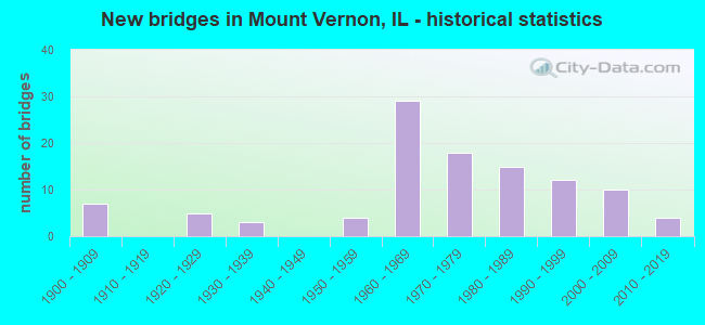
- New bridges - historical statistics
- 71900-1909
- 51920-1929
- 31930-1939
- 41950-1959
- 291960-1969
- 181970-1979
- 151980-1989
- 121990-1999
- 102000-2009
- 42010-2019

- Reconstructed bridges - Historical Statistics
- 11940-1949
- 11950-1959
- 21960-1969
- 01970-1979
- 11980-1989
- 81990-1999
- 12000-2009


- Bridge Condition - Deck
- 19.4%Very good
- 28.4%Good
- 40.3%Satisfactory
- 7.5%Fair
- 3.0%Poor
- 1.5%Critical

- Bridge Condition - Superstructure
- 22.4%Very good
- 20.9%Good
- 37.3%Satisfactory
- 10.4%Fair
- 6.0%Poor
- 1.5%Serious
- 1.5%Critical

- Bridge Condition - Substructure
- 38.8%Very good
- 37.3%Good
- 11.9%Satisfactory
- 10.4%Fair
- 1.5%Poor

- Bridge Condition - Channel
- 22.7%Very good
- 51.5%Good
- 18.2%Satisfactory
- 7.6%Fair

- Bridge Condition - Culverts
- 20.0%Very good
- 45.0%Good
- 25.0%Satisfactory
- 10.0%Fair
Find on map >> Show street view
Structure Number: 410003, Location: 2 MI S OF S TRI-LEVL (Lat: 38.246856, Lng: -88.906236), Route carried "on" structure: Interstate 57, Year Built: 1965, Status: Open, Structure Length: 3.66m (12.01ft), Average Daily Traffic: 19,950 (year 2021), Truck Traffic: 40%, Average Future Daily Traffic: 15,581 (year 2032), Design Load: HS 20+Mod, Features Intersected: DODDS CREEK
Minimum Vertical Clearance: 30+ m (98+ ft), Kilometerpoint: 143.598, Lanes on structure: 2, Base Highway Network: Yes, Owner: State Highway Agency, Approaching Roadway Width: 12.8m (42.0ft), Material/Design: Concrete continuous, Design/Construction: Slab, Number Of Spans In Main Unit: 3, Length of Maximum Span: 13.7m (44.9ft), Curb-To-Curb Width: 11.9m (39.0ft), Out-to-Out Width: 13.0m (42.7ft)
Condition: Deck: Satisfactory, Superstructure: Satisfactory, Substructure: Good, Channel: Good, Operating Rating: 72.9 metric tons, Method Used To Determine Operating Rating: Load Factor (LF) rating reported by rating factor (RF) method using MS18 loading, Inventory Rating: 43.7 metric tons, Method Used To Determine Inventory Rating: Load Factor (LF) rating reported by rating factor (RF) method using MS18 loading, Structural Evaluation: Equal to present minimum criteria, Deck Geometry: Equal to present minimum criteria, Waterway Adequacy: Equal to present desirable criteria, Approach Roadway Alignment: Equal to present desirable criteria, Designated Inspection Frequency: Every 24 months, Inspection Date: Febuary 2021, Deck Structure Type: Concrete Cast-file-Place, Wearing Surface/Protective System: Wearing Surface: Integral Concrete, Deck Protection: Epoxy Coated Reinforcing
Find on map >> Show street view
Structure Number: 410004, Location: 2 MI S OF S TRI-LEVL (Lat: 38.247000, Lng: -88.906267), Route carried "on" structure: Interstate 57, Year Built: 1965, Status: Open, Structure Length: 3.66m (12.01ft), Average Daily Traffic: 19,950 (year 2021), Truck Traffic: 40%, Average Future Daily Traffic: 15,581 (year 2032), Design Load: HS 20+Mod, Features Intersected: DODDS CREEK
Minimum Vertical Clearance: 30+ m (98+ ft), Kilometerpoint: 143.614, Lanes on structure: 2, Base Highway Network: Yes, Owner: State Highway Agency, Approaching Roadway Width: 12.8m (42.0ft), Material/Design: Concrete continuous, Design/Construction: Slab, Number Of Spans In Main Unit: 3, Length of Maximum Span: 13.7m (44.9ft), Curb-To-Curb Width: 11.9m (39.0ft), Out-to-Out Width: 13.0m (42.7ft)
Condition: Deck: Satisfactory, Superstructure: Satisfactory, Substructure: Good, Channel: Good, Operating Rating: 72.9 metric tons, Method Used To Determine Operating Rating: Load Factor (LF) rating reported by rating factor (RF) method using MS18 loading, Inventory Rating: 43.7 metric tons, Method Used To Determine Inventory Rating: Load Factor (LF) rating reported by rating factor (RF) method using MS18 loading, Structural Evaluation: Equal to present minimum criteria, Deck Geometry: Equal to present minimum criteria, Waterway Adequacy: Equal to present desirable criteria, Approach Roadway Alignment: Equal to present desirable criteria, Designated Inspection Frequency: Every 24 months, Inspection Date: Febuary 2021, Deck Structure Type: Concrete Cast-file-Place, Wearing Surface/Protective System: Wearing Surface: Integral Concrete, Deck Protection: Epoxy Coated Reinforcing
Find on map >> Show street view
Structure Number: 410005, Location: 4.5 MI S ILL-15 INT (Lat: 38.253428, Lng: -88.911206), Route carried "on" structure: Interstate 57, Year Built: 1966, Year Reconstructed: 2002, Status: Open, Structure Length: 8.81m (28.90ft), Average Daily Traffic: 19,950 (year 2021), Truck Traffic: 40%, Average Future Daily Traffic: 15,581 (year 2032), Design Load: HS 20+Mod, Features Intersected: CASEY FORK CREEK
Minimum Vertical Clearance: 30+ m (98+ ft), Kilometerpoint: 144.467, Lanes on structure: 2, Base Highway Network: Yes, Owner: State Highway Agency, Approaching Roadway Width: 12.2m (40.0ft), Material/Design: Steel continuous, Design/Construction: Stringer/Multi-beam, Number Of Spans In Main Unit: 5, Length of Maximum Span: 18.6m (61.0ft), Curb-To-Curb Width: 17.3m (56.8ft), Out-to-Out Width: 19.3m (63.3ft)
Condition: Deck: Good, Superstructure: Good, Substructure: Very good, Channel: Good, Operating Rating: 89.1 metric tons, Method Used To Determine Operating Rating: Load Factor (LF) rating reported by rating factor (RF) method using MS18 loading, Inventory Rating: 61.9 metric tons, Method Used To Determine Inventory Rating: Load Factor (LF) rating reported by rating factor (RF) method using MS18 loading, Structural Evaluation: Better than present minimum criteria, Deck Geometry: Superior to present desirable criteria, Waterway Adequacy: Equal to present desirable criteria, Approach Roadway Alignment: Equal to present desirable criteria, Designated Inspection Frequency: Every 24 months, Inspection Date: Febuary 2021, Deck Structure Type: Concrete Cast-file-Place, Wearing Surface/Protective System: Deck Protection: Epoxy Coated Reinforcing
Find on map >> Show street view
Structure Number: 410006, Location: 4.5 MI S ILL-15 INT (Lat: 38.253514, Lng: -88.911353), Route carried "on" structure: Interstate 57, Year Built: 1966, Year Reconstructed: 2002, Status: Open, Structure Length: 8.81m (28.90ft), Average Daily Traffic: 19,950 (year 2021), Truck Traffic: 40%, Average Future Daily Traffic: 15,581 (year 2032), Design Load: HS 20+Mod, Features Intersected: CASEY FORK CREEK
Minimum Vertical Clearance: 30+ m (98+ ft), Kilometerpoint: 144.483, Lanes on structure: 2, Base Highway Network: Yes, Owner: State Highway Agency, Approaching Roadway Width: 12.2m (40.0ft), Material/Design: Steel continuous, Design/Construction: Stringer/Multi-beam, Number Of Spans In Main Unit: 5, Length of Maximum Span: 18.6m (61.0ft), Curb-To-Curb Width: 17.3m (56.8ft), Out-to-Out Width: 19.3m (63.3ft)
Condition: Deck: Good, Superstructure: Good, Substructure: Very good, Channel: Good, Operating Rating: 89.1 metric tons, Method Used To Determine Operating Rating: Load Factor (LF) rating reported by rating factor (RF) method using MS18 loading, Inventory Rating: 61.9 metric tons, Method Used To Determine Inventory Rating: Load Factor (LF) rating reported by rating factor (RF) method using MS18 loading, Structural Evaluation: Better than present minimum criteria, Deck Geometry: Superior to present desirable criteria, Waterway Adequacy: Equal to present desirable criteria, Approach Roadway Alignment: Equal to present desirable criteria, Designated Inspection Frequency: Every 24 months, Inspection Date: Febuary 2021, Deck Structure Type: Concrete Cast-file-Place, Wearing Surface/Protective System: Deck Protection: Epoxy Coated Reinforcing
Find on map >> Show street view
Structure Number: 410007, Location: TRI-LEVEL S MT VERON (Lat: 38.270697, Lng: -88.931967), Route carried "on" structure: Interstate 57, Year Built: 1968, Status: Open, Structure Length: 7.22m (23.69ft), Average Daily Traffic: 19,950 (year 2021), Truck Traffic: 40%, Average Future Daily Traffic: 15,581 (year 2032), Design Load: HS 20+Mod, Features Intersected: FAI-64 EB
Minimum Vertical Clearance: 5.31m (17.42ft), Kilometerpoint: 147.251, Lanes on structure: 2, Lanes under structure: 2, Base Highway Network: Yes, Owner: State Highway Agency, Approaching Roadway Width: 12.2m (40.0ft), Skew: 3 degrees, Material/Design: Steel continuous, Design/Construction: Frame, Number Of Spans In Main Unit: 3, Length of Maximum Span: 39.0m (128.0ft), Curb-To-Curb Width: 12.3m (40.4ft), Out-to-Out Width: 13.5m (44.3ft)
Condition: Deck: Satisfactory, Superstructure: Satisfactory, Substructure: Satisfactory, Operating Rating: 60.3 metric tons, Method Used To Determine Operating Rating: Load Factor (LF) rating reported by rating factor (RF) method using MS18 loading, Inventory Rating: 33.7 metric tons, Method Used To Determine Inventory Rating: Load Factor (LF) rating reported by rating factor (RF) method using MS18 loading, Structural Evaluation: Equal to present minimum criteria, Deck Geometry: Better than present minimum criteria, Underclear: High priority of replacement, Approach Roadway Alignment: Equal to present desirable criteria, Length Of Structure Improvement: 7.22m (23.69ft), Designated Inspection Frequency: Every 24 months, Inspection Date: December 2021, Bridge Improvement Cost: $1,140,000, Roadway Improvement Cost: $190,000, Total Project Cost: $1,330,000, Deck Structure Type: Concrete Cast-file-Place, Wearing Surface/Protective System: Wearing Surface: Other
Find on map >> Show street view
Structure Number: 410008, Location: 2 MI S ILL-15 INT (Lat: 38.283919, Lng: -88.939350), Route carried "on" structure: Interstate 57, Year Built: 1968, Year Reconstructed: 2003, Status: Open, Structure Length: 7.80m (25.59ft), Average Daily Traffic: 22,350 (year 2021), Truck Traffic: 34%, Average Future Daily Traffic: 19,835 (year 2032), Design Load: HS 20+Mod, Features Intersected: FAP-726 & UN PACF RR
Minimum Vertical Clearance: 30+ m (98+ ft), Kilometerpoint: 148.844, Lanes on structure: 2, Lanes under structure: 2, Base Highway Network: Yes, Owner: State Highway Agency, Approaching Roadway Width: 17.2m (56.4ft), Material/Design: Steel continuous, Design/Construction: Stringer/Multi-beam, Number Of Spans In Main Unit: 4, Length of Maximum Span: 24.1m (79.1ft), Curb-To-Curb Width: 17.2m (56.4ft), Out-to-Out Width: 18.2m (59.7ft)
Condition: Deck: Good, Superstructure: Good, Substructure: Very good, Operating Rating: 83.3 metric tons, Method Used To Determine Operating Rating: Load Factor (LF) rating reported by rating factor (RF) method using MS18 loading, Inventory Rating: 49.9 metric tons, Method Used To Determine Inventory Rating: Load Factor (LF) rating reported by rating factor (RF) method using MS18 loading, Structural Evaluation: Better than present minimum criteria, Deck Geometry: Superior to present desirable criteria, Underclear: Equal to present minimum criteria, Approach Roadway Alignment: Equal to present desirable criteria, Designated Inspection Frequency: Every 24 months, Inspection Date: December 2020, Deck Structure Type: Concrete Cast-file-Place, Wearing Surface/Protective System: Deck Protection: Epoxy Coated Reinforcing
Find on map >> Show street view
Structure Number: 410009, Location: 2 MI S ILL-15 INT (Lat: 38.284108, Lng: -88.939431), Route carried "on" structure: Interstate 57, Year Built: 1968, Year Reconstructed: 2003, Status: Open, Structure Length: 7.80m (25.59ft), Average Daily Traffic: 22,350 (year 2021), Truck Traffic: 34%, Average Future Daily Traffic: 19,835 (year 2032), Design Load: HS 20+Mod, Features Intersected: FAP-726 & UN PACF RR
Minimum Vertical Clearance: 30+ m (98+ ft), Kilometerpoint: 148.860, Lanes on structure: 2, Lanes under structure: 2, Base Highway Network: Yes, Owner: State Highway Agency, Approaching Roadway Width: 17.2m (56.4ft), Material/Design: Steel continuous, Design/Construction: Stringer/Multi-beam, Number Of Spans In Main Unit: 4, Length of Maximum Span: 24.1m (79.1ft), Curb-To-Curb Width: 17.2m (56.4ft), Out-to-Out Width: 18.2m (59.7ft)
Condition: Deck: Good, Superstructure: Good, Substructure: Very good, Operating Rating: 83.3 metric tons, Method Used To Determine Operating Rating: Load Factor (LF) rating reported by rating factor (RF) method using MS18 loading, Inventory Rating: 49.9 metric tons, Method Used To Determine Inventory Rating: Load Factor (LF) rating reported by rating factor (RF) method using MS18 loading, Structural Evaluation: Better than present minimum criteria, Deck Geometry: Superior to present desirable criteria, Underclear: Equal to present minimum criteria, Approach Roadway Alignment: Equal to present desirable criteria, Designated Inspection Frequency: Every 24 months, Inspection Date: December 2020, Deck Structure Type: Concrete Cast-file-Place, Wearing Surface/Protective System: Deck Protection: Epoxy Coated Reinforcing
Find on map >> Show street view
Structure Number: 410012, Location: 1.0 MI N ILL-15 INT (Lat: 38.328097, Lng: -88.955547), Route carried "on" structure: Interstate 57, Year Built: 1967, Status: Open, Structure Length: 4.33m (14.21ft), Average Daily Traffic: 23,750 (year 2021), Truck Traffic: 41%, Average Future Daily Traffic: 20,222 (year 2032), Design Load: HS 20+Mod, Features Intersected: L & N RR
Minimum Vertical Clearance: 30+ m (98+ ft), Kilometerpoint: 153.962, Lanes on structure: 2, Base Highway Network: Yes, Owner: State Highway Agency, Approaching Roadway Width: 16.5m (54.1ft), Skew: 1 degrees, Material/Design: Steel continuous, Design/Construction: Stringer/Multi-beam, Number Of Spans In Main Unit: 3, Length of Maximum Span: 15.5m (50.9ft), Curb-To-Curb Width: 17.0m (55.8ft), Out-to-Out Width: 18.0m (59.1ft)
Condition: Deck: Fair, Superstructure: Satisfactory, Substructure: Good, Operating Rating: 52.2 metric tons, Method Used To Determine Operating Rating: Load Factor (LF) rating reported by rating factor (RF) method using MS18 loading, Inventory Rating: 32.4 metric tons, Method Used To Determine Inventory Rating: Load Factor (LF) rating reported by rating factor (RF) method using MS18 loading, Structural Evaluation: Equal to present minimum criteria, Deck Geometry: Superior to present desirable criteria, Underclear: Better than present minimum criteria, Approach Roadway Alignment: Equal to present desirable criteria, Designated Inspection Frequency: Every 24 months, Inspection Date: Febuary 2022, Deck Structure Type: Concrete Cast-file-Place, Wearing Surface/Protective System: Wearing Surface: Other
Find on map >> Show street view
Structure Number: 410013, Location: 1.0 MI N ILL-15 INT (Lat: 38.328219, Lng: -88.955522), Route carried "on" structure: Interstate 57, Year Built: 1967, Status: Open, Structure Length: 4.33m (14.21ft), Average Daily Traffic: 23,750 (year 2021), Truck Traffic: 41%, Average Future Daily Traffic: 20,222 (year 2032), Design Load: HS 20+Mod, Features Intersected: L & N RR
Minimum Vertical Clearance: 30+ m (98+ ft), Kilometerpoint: 153.978, Lanes on structure: 2, Base Highway Network: Yes, Owner: State Highway Agency, Approaching Roadway Width: 16.5m (54.1ft), Material/Design: Steel continuous, Design/Construction: Stringer/Multi-beam, Number Of Spans In Main Unit: 3, Length of Maximum Span: 15.5m (50.9ft), Curb-To-Curb Width: 16.6m (54.5ft), Out-to-Out Width: 17.7m (58.1ft)
Condition: Deck: Satisfactory, Superstructure: Satisfactory, Substructure: Good, Operating Rating: 53.1 metric tons, Method Used To Determine Operating Rating: Load Factor (LF) rating reported by rating factor (RF) method using MS18 loading, Inventory Rating: 32.4 metric tons, Method Used To Determine Inventory Rating: Load Factor (LF) rating reported by rating factor (RF) method using MS18 loading, Structural Evaluation: Equal to present minimum criteria, Deck Geometry: Superior to present desirable criteria, Underclear: Superior to present desirable criteria, Approach Roadway Alignment: Equal to present desirable criteria, Designated Inspection Frequency: Every 24 months, Inspection Date: Febuary 2022, Deck Structure Type: Concrete Cast-file-Place, Wearing Surface/Protective System: Wearing Surface: Other
Find on map >> Show street view
Structure Number: 410024, Location: 9 MI E WASH CO LN (Lat: 38.309578, Lng: -88.980667), Route carried "on" structure: State highway 15, Year Built: 1923, Year Reconstructed: 1971, Status: Temporarily open, Structure Length: 1.01m (3.31ft), Average Daily Traffic: 5,500 (year 2021), Truck Traffic: 7%, Average Future Daily Traffic: 6,299 (year 2032), Design Load: HS 20, Features Intersected: BIG MUDDY OVERFLOW
Minimum Vertical Clearance: 30+ m (98+ ft), Kilometerpoint: 119.957, Lanes on structure: 2, Base Highway Network: Yes, Owner: State Highway Agency, Approaching Roadway Width: 9.1m (29.9ft), Material/Design: Prestressed concrete, Design/Construction: Box Beam or Girders - Multiple, Number Of Spans In Main Unit: 1, Length of Maximum Span: 9.8m (32.2ft), Curb-To-Curb Width: 10.2m (33.5ft), Out-to-Out Width: 10.2m (33.5ft)
Condition: Deck: Critical, Superstructure: Critical, Substructure: Satisfactory, Channel: Good, Operating Rating: 68.4 metric tons, Method Used To Determine Operating Rating: Load Factor (LF) rating reported by rating factor (RF) method using MS18 loading, Inventory Rating: 40.8 metric tons, Method Used To Determine Inventory Rating: Load Factor (LF) rating reported by rating factor (RF) method using MS18 loading, Structural Evaluation: High priority of replacement, Deck Geometry: Meets minimum limits, Waterway Adequacy: Equal to present minimum criteria, Approach Roadway Alignment: Equal to present desirable criteria, Length Of Structure Improvement: 1.01m (3.31ft), Designated Inspection Frequency: Every 12 months, Inspection Date: Febuary 2022, Bridge Improvement Cost: $132,000, Roadway Improvement Cost: $22,000, Total Project Cost: $154,000, Deck Structure Type: Concrete Precast Panels, Wearing Surface/Protective System: Wearing Surface: Bituminous, Membrane: Built-up
Find on map >> Show street view
Structure Number: 410025, Location: I-57 INTERCHANGE (Lat: 38.312669, Lng: -88.951692), Route carried "on" structure: State highway 15, Year Built: 1968, Status: Open, Structure Length: 10.06m (33.01ft), Average Daily Traffic: 18,100 (year 2021), Truck Traffic: 18%, Average Future Daily Traffic: 26,631 (year 2032), Design Load: HS 20, Features Intersected: FAI-57
Minimum Vertical Clearance: 30+ m (98+ ft), Kilometerpoint: 122.419, Lanes on structure: 4, Lanes under structure: 4, Base Highway Network: Yes, Owner: State Highway Agency, Approaching Roadway Width: 21.9m (71.9ft), Skew: 32 degrees, Material/Design: Steel continuous, Design/Construction: Frame, Number Of Spans In Main Unit: 4, Length of Maximum Span: 36.6m (120.1ft), Curb-To-Curb Width: 20.6m (67.6ft), Out-to-Out Width: 26.7m (87.6ft)
Condition: Deck: Fair, Superstructure: Poor, Substructure: Fair, Operating Rating: 59.3 metric tons, Method Used To Determine Operating Rating: Load Factor (LF) rating reported by rating factor (RF) method using MS18 loading, Inventory Rating: 31.4 metric tons, Method Used To Determine Inventory Rating: Load Factor (LF) rating reported by rating factor (RF) method using MS18 loading, Structural Evaluation: Meets minimum limits, Deck Geometry: Superior to present desirable criteria, Underclear: Somewhat better than minimum adequacy, Approach Roadway Alignment: Equal to present desirable criteria, Designated Inspection Frequency: Every 12 months, Inspection Date: November 2021, Deck Structure Type: Concrete Cast-file-Place, Wearing Surface/Protective System: Wearing Surface: Other
Find on map >> Show street view
Structure Number: 410026, Location: ECL MT VERNON (Lat: 38.317217, Lng: -88.885933), Route carried "on" structure: State highway 15, Year Built: 1957, Year Reconstructed: 1990, Status: Open, Structure Length: 4.34m (14.24ft), Average Daily Traffic: 6,250 (year 2021), Truck Traffic: 11%, Average Future Daily Traffic: 8,177 (year 2032), Design Load: HS 20, Features Intersected: CASEY FORK
Minimum Vertical Clearance: 30+ m (98+ ft), Kilometerpoint: 128.358, Lanes on structure: 2, Base Highway Network: Yes, Owner: State Highway Agency, Approaching Roadway Width: 9.1m (29.9ft), Skew: 1 degrees, Material/Design: Steel continuous, Design/Construction: Stringer/Multi-beam, Number Of Spans In Main Unit: 3, Length of Maximum Span: 15.6m (51.2ft), Curb-To-Curb Width: 12.2m (40.0ft), Out-to-Out Width: 13.2m (43.3ft)
Condition: Deck: Satisfactory, Superstructure: Satisfactory, Substructure: Good, Channel: Very good, Operating Rating: 85.5 metric tons, Method Used To Determine Operating Rating: Load Factor (LF) rating reported by rating factor (RF) method using MS18 loading, Inventory Rating: 51.5 metric tons, Method Used To Determine Inventory Rating: Load Factor (LF) rating reported by rating factor (RF) method using MS18 loading, Structural Evaluation: Equal to present minimum criteria, Deck Geometry: Somewhat better than minimum adequacy, Waterway Adequacy: Equal to present desirable criteria, Approach Roadway Alignment: Equal to present desirable criteria, Designated Inspection Frequency: Every 24 months, Inspection Date: August 2021, Deck Structure Type: Concrete Cast-file-Place, Wearing Surface/Protective System: Wearing Surface: Bituminous, Membrane: Built-up, Deck Protection: Epoxy Coated Reinforcing
Find on map >> Show street view
Structure Number: 410027, Location: 2 MI E MT VERNON (Lat: 38.318894, Lng: -88.847875), Route carried "on" structure: State highway 15, Year Built: 1957, Year Reconstructed: 2007, Status: Open, Structure Length: 5.12m (16.80ft), Average Daily Traffic: 4,200 (year 2021), Truck Traffic: 8%, Average Future Daily Traffic: 6,409 (year 2032), Design Load: HS 20, Features Intersected: SEVEN MILE CREEK
Minimum Vertical Clearance: 30+ m (98+ ft), Kilometerpoint: 131.673, Lanes on structure: 2, Base Highway Network: Yes, Owner: State Highway Agency, Approaching Roadway Width: 12.2m (40.0ft), Skew: 3 degrees, Material/Design: Steel continuous, Design/Construction: Stringer/Multi-beam, Number Of Spans In Main Unit: 3, Length of Maximum Span: 18.6m (61.0ft), Curb or Sidewalk Widths: Left: 0.6m (2.0ft), Right: 0.6m (2.0ft), Curb-To-Curb Width: 8.5m (27.9ft), Out-to-Out Width: 13.5m (44.3ft)
Condition: Deck: Very good, Superstructure: Satisfactory, Substructure: Good, Channel: Satisfactory, Operating Rating: 85.9 metric tons, Method Used To Determine Operating Rating: Load Factor (LF) rating reported by rating factor (RF) method using MS18 loading, Inventory Rating: 51.5 metric tons, Method Used To Determine Inventory Rating: Load Factor (LF) rating reported by rating factor (RF) method using MS18 loading, Structural Evaluation: Equal to present minimum criteria, Deck Geometry: Meets minimum limits, Waterway Adequacy: Equal to present desirable criteria, Approach Roadway Alignment: Equal to present desirable criteria, Length Of Structure Improvement: 6.16m (20.21ft), Designated Inspection Frequency: Every 24 months, Inspection Date: November 2021, Bridge Improvement Cost: $918,000, Roadway Improvement Cost: $92,000, Total Project Cost: $1,378,000, Deck Structure Type: Concrete Cast-file-Place, Wearing Surface/Protective System: Deck Protection: Epoxy Coated Reinforcing
Find on map >> Show street view
Structure Number: 410031, Location: 1.5 MI S ILL-148 (Lat: 38.283744, Lng: -88.902817), Route carried "on" structure: State highway 37, Year Built: 1921, Year Reconstructed: 1951, Status: Open, Structure Length: 1.01m (3.31ft), Average Daily Traffic: 6,100 (year 2021), Truck Traffic: 11%, Average Future Daily Traffic: 6,409 (year 2032), Design Load: H 20, Features Intersected: STREAM
Minimum Vertical Clearance: 30+ m (98+ ft), Kilometerpoint: 149.681, Lanes on structure: 2, Base Highway Network: Yes, Owner: State Highway Agency, Approaching Roadway Width: 9.1m (29.9ft), Material/Design: Concrete continuous, Design/Construction: Slab, Number Of Spans In Main Unit: 3, Length of Maximum Span: 10.1m (33.1ft), Curb-To-Curb Width: 11.6m (38.1ft), Out-to-Out Width: 12.2m (40.0ft)
Condition: Deck: Poor, Superstructure: Poor, Substructure: Satisfactory, Channel: Good, Operating Rating: 35.0 metric tons, Method Used To Determine Operating Rating: Load Factor (LF) rating reported by rating factor (RF) method using MS18 loading, Inventory Rating: 21.1 metric tons, Method Used To Determine Inventory Rating: Load Factor (LF) rating reported by rating factor (RF) method using MS18 loading, Structural Evaluation: Meets minimum limits, Deck Geometry: Somewhat better than minimum adequacy, Waterway Adequacy: Equal to present desirable criteria, Approach Roadway Alignment: Equal to present desirable criteria, Designated Inspection Frequency: Every 12 months, Inspection Date: Febuary 2022, Deck Structure Type: Concrete Cast-file-Place, Wearing Surface/Protective System: Wearing Surface: Bituminous
Find on map >> Show street view
Structure Number: 410032, Location: 2 MI S ILL-148 (Lat: 38.270061, Lng: -88.899019), Route carried "on" structure: State highway 37, Year Built: 1921, Year Reconstructed: 1986, Status: Open, Structure Length: 11.73m (38.48ft), Average Daily Traffic: 4,950 (year 2021), Truck Traffic: 8%, Average Future Daily Traffic: 4,862 (year 2032), Design Load: HS 20, Features Intersected: CASEY FORK
Minimum Vertical Clearance: 30+ m (98+ ft), Kilometerpoint: 148.120, Lanes on structure: 2, Owner: State Highway Agency, Approaching Roadway Width: 6.7m (22.0ft), Skew: 3 degrees, Material/Design: Steel continuous, Design/Construction: Stringer/Multi-beam, Number Of Spans In Main Unit: 2, Number Of Approach Spans: 6, Length of Maximum Span: 18.3m (60.0ft), Curb-To-Curb Width: 9.8m (32.2ft), Out-to-Out Width: 10.7m (35.1ft)
Condition: Deck: Good, Superstructure: Satisfactory, Substructure: Fair, Channel: Good, Operating Rating: 69.3 metric tons, Method Used To Determine Operating Rating: Load Factor (LF) rating reported by rating factor (RF) method using MS18 loading, Inventory Rating: 41.5 metric tons, Method Used To Determine Inventory Rating: Load Factor (LF) rating reported by rating factor (RF) method using MS18 loading, Structural Evaluation: Somewhat better than minimum adequacy, Deck Geometry: Meets minimum limits, Waterway Adequacy: Equal to present desirable criteria, Approach Roadway Alignment: Equal to present desirable criteria, Designated Inspection Frequency: Every 24 months, Inspection Date: August 2021, Deck Structure Type: Concrete Cast-file-Place, Wearing Surface/Protective System: Deck Protection: Epoxy Coated Reinforcing
Find on map >> Show street view
Structure Number: 41004, Location: .5 MI S MT VERNON (Lat: 38.288711, Lng: -88.875142), Route carried "on" structure: State highway 142, Year Built: 1930, Year Reconstructed: 1990, Status: Open, Structure Length: 3.82m (12.53ft), Average Daily Traffic: 5,150 (year 2019), Truck Traffic: 4%, Average Future Daily Traffic: 6,464 (year 2032), Design Load: HS 20, Features Intersected: BRANCH OF CASEY FORK
Minimum Vertical Clearance: 30+ m (98+ ft), Kilometerpoint: 84.971, Lanes on structure: 2, Base Highway Network: Yes, Owner: State Highway Agency, Approaching Roadway Width: 9.8m (32.2ft), Skew: 4 degrees, Material/Design: Steel continuous, Design/Construction: Stringer/Multi-beam, Number Of Spans In Main Unit: 2, Length of Maximum Span: 18.3m (60.0ft), Curb-To-Curb Width: 11.0m (36.1ft), Out-to-Out Width: 11.9m (39.0ft)
Condition: Deck: Good, Superstructure: Satisfactory, Substructure: Good, Channel: Good, Operating Rating: 58.6 metric tons, Method Used To Determine Operating Rating: Load Factor (LF) rating reported by rating factor (RF) method using MS18 loading, Inventory Rating: 35.3 metric tons, Method Used To Determine Inventory Rating: Load Factor (LF) rating reported by rating factor (RF) method using MS18 loading, Structural Evaluation: Equal to present minimum criteria, Deck Geometry: Meets minimum limits, Waterway Adequacy: Equal to present desirable criteria, Approach Roadway Alignment: Equal to present desirable criteria, Designated Inspection Frequency: Every 24 months, Inspection Date: September 2021, Deck Structure Type: Concrete Cast-file-Place, Wearing Surface/Protective System: Wearing Surface: Other, Deck Protection: Epoxy Coated Reinforcing
Find on map >> Show street view
Structure Number: 410041, Location: .7 MI S MT VERNON (Lat: 38.287725, Lng: -88.873553), Route carried "on" structure: State highway 142, Year Built: 1930, Year Reconstructed: 1990, Status: Open, Structure Length: 3.79m (12.43ft), Average Daily Traffic: 5,150 (year 2019), Truck Traffic: 4%, Average Future Daily Traffic: 6,464 (year 2032), Design Load: HS 20, Features Intersected: CASEY FORK OVERFLOW
Minimum Vertical Clearance: 30+ m (98+ ft), Kilometerpoint: 84.794, Lanes on structure: 2, Base Highway Network: Yes, Owner: State Highway Agency, Approaching Roadway Width: 9.1m (29.9ft), Skew: 3 degrees, Material/Design: Steel continuous, Design/Construction: Stringer/Multi-beam, Number Of Spans In Main Unit: 2, Length of Maximum Span: 18.3m (60.0ft), Curb-To-Curb Width: 11.0m (36.1ft), Out-to-Out Width: 11.9m (39.0ft)
Condition: Deck: Good, Superstructure: Fair, Substructure: Good, Channel: Good, Operating Rating: 65.4 metric tons, Method Used To Determine Operating Rating: Load Factor (LF) rating reported by rating factor (RF) method using MS18 loading, Inventory Rating: 33.0 metric tons, Method Used To Determine Inventory Rating: Load Factor (LF) rating reported by rating factor (RF) method using MS18 loading, Structural Evaluation: Somewhat better than minimum adequacy, Deck Geometry: Meets minimum limits, Waterway Adequacy: Equal to present desirable criteria, Approach Roadway Alignment: Equal to present desirable criteria, Designated Inspection Frequency: Every 24 months, Inspection Date: August 2021, Deck Structure Type: Concrete Cast-file-Place, Wearing Surface/Protective System: Wearing Surface: Epoxy Overlay, Deck Protection: Epoxy Coated Reinforcing
Find on map >> Show street view
Structure Number: 410042, Location: .9 MI S MT VERNON (Lat: 38.286758, Lng: -88.872186), Route carried "on" structure: State highway 142, Year Built: 1930, Year Reconstructed: 1990, Status: Open, Structure Length: 5.07m (16.63ft), Average Daily Traffic: 5,150 (year 2019), Truck Traffic: 4%, Average Future Daily Traffic: 6,464 (year 2032), Design Load: HS 20, Features Intersected: CASEY FORK
Minimum Vertical Clearance: 30+ m (98+ ft), Kilometerpoint: 84.633, Lanes on structure: 2, Base Highway Network: Yes, Owner: State Highway Agency, Approaching Roadway Width: 9.1m (29.9ft), Material/Design: Steel continuous, Design/Construction: Stringer/Multi-beam, Number Of Spans In Main Unit: 3, Length of Maximum Span: 18.8m (61.7ft), Curb-To-Curb Width: 11.0m (36.1ft), Out-to-Out Width: 11.9m (39.0ft)
Condition: Deck: Satisfactory, Superstructure: Fair, Substructure: Good, Channel: Good, Operating Rating: 62.5 metric tons, Method Used To Determine Operating Rating: Load Factor (LF) rating reported by rating factor (RF) method using MS18 loading, Inventory Rating: 37.9 metric tons, Method Used To Determine Inventory Rating: Load Factor (LF) rating reported by rating factor (RF) method using MS18 loading, Structural Evaluation: Somewhat better than minimum adequacy, Deck Geometry: Meets minimum limits, Waterway Adequacy: Equal to present desirable criteria, Approach Roadway Alignment: Equal to present desirable criteria, Designated Inspection Frequency: Every 24 months, Inspection Date: August 2021, Deck Structure Type: Concrete Cast-file-Place, Wearing Surface/Protective System: Wearing Surface: Epoxy Overlay, Deck Protection: Epoxy Coated Reinforcing
Find on map >> Show street view
Structure Number: 410043, Location: 1.8 MI S MT VERNON (Lat: 38.278025, Lng: -88.864861), Route carried "on" structure: State highway 142, Year Built: 1928, Status: Open, Structure Length: 0.79m (2.59ft), Average Daily Traffic: 3,600 (year 2021), Truck Traffic: 4%, Average Future Daily Traffic: 4,917 (year 2032), Features Intersected: STREAM
Minimum Vertical Clearance: 30+ m (98+ ft), Kilometerpoint: 83.474, Lanes on structure: 2, Base Highway Network: Yes, Owner: State Highway Agency, Approaching Roadway Width: 9.1m (29.9ft), Material/Design: Concrete, Design/Construction: Slab, Number Of Spans In Main Unit: 1, Length of Maximum Span: 7.6m (24.9ft), Curb-To-Curb Width: 9.9m (32.5ft), Out-to-Out Width: 11.0m (36.1ft)
Condition: Deck: Poor, Superstructure: Poor, Substructure: Fair, Channel: Fair, Operating Rating: 53.1 metric tons, Method Used To Determine Operating Rating: Load Factor (LF) rating reported by rating factor (RF) method using MS18 loading, Inventory Rating: 31.8 metric tons, Method Used To Determine Inventory Rating: Load Factor (LF) rating reported by rating factor (RF) method using MS18 loading, Structural Evaluation: Meets minimum limits, Deck Geometry: Meets minimum limits, Waterway Adequacy: Equal to present minimum criteria, Approach Roadway Alignment: Equal to present desirable criteria, Designated Inspection Frequency: Every 12 months, Inspection Date: Febuary 2022, Deck Structure Type: Concrete Cast-file-Place, Wearing Surface/Protective System: Wearing Surface: Bituminous, Membrane: Built-up
Find on map >> Show street view
Structure Number: 410049, Location: .25 MI NE ILL-15 (Lat: 38.319650, Lng: -88.883222), Route carried "on" structure: Other road , Year Built: 1925, Status: Open, Structure Length: 0.79m (2.59ft), Average Daily Traffic: 5,700 (year 2021), Truck Traffic: 11%, Average Future Daily Traffic: 7,293 (year 2032), Features Intersected: STREAM, Facility Carried by Structure: FAU-8715 (OLD-15)
Minimum Vertical Clearance: 30+ m (98+ ft), Kilometerpoint: 0.499, Lanes on structure: 2, Owner: City or Municipal Highway Agency, Approaching Roadway Width: 7.9m (25.9ft), Material/Design: Concrete, Design/Construction: Slab, Number Of Spans In Main Unit: 1, Length of Maximum Span: 7.6m (24.9ft), Curb-To-Curb Width: 9.3m (30.5ft), Out-to-Out Width: 9.8m (32.2ft)
Condition: Deck: Satisfactory, Superstructure: Satisfactory, Substructure: Good, Channel: Good, Operating Rating: 39.9 metric tons, Method Used To Determine Operating Rating: Load Factor (LF) rating reported by rating factor (RF) method using MS18 loading, Inventory Rating: 24.0 metric tons, Method Used To Determine Inventory Rating: Load Factor (LF) rating reported by rating factor (RF) method using MS18 loading, Structural Evaluation: Somewhat better than minimum adequacy, Deck Geometry: High priority of corrective action, Waterway Adequacy: Equal to present desirable criteria, Approach Roadway Alignment: Equal to present desirable criteria, Length Of Structure Improvement: 1.43m (4.69ft), Designated Inspection Frequency: Every 24 months, Inspection Date: September 2021, Bridge Improvement Cost: $133,000, Roadway Improvement Cost: $13,000, Total Project Cost: $200,000, Deck Structure Type: Concrete Cast-file-Place, Wearing Surface/Protective System: Wearing Surface: Bituminous
Find on map >> Show street view
Structure Number: 410051, Location: 2 MI N ILL-15 (Lat: 38.342147, Lng: -88.954028), Route carried "on" structure: County highway , Year Built: 1968, Status: Open, Structure Length: 7.77m (25.49ft), Average Daily Traffic: 2,550 (year 2021), Truck Traffic: 4%, Average Future Daily Traffic: 2,763 (year 2032), Design Load: HS 15, Features Intersected: FAI-57, Facility Carried by Structure: FAS-826 (CH-10)
Minimum Vertical Clearance: 30+ m (98+ ft), Kilometerpoint: 18.652, Lanes on structure: 2, Lanes under structure: 4, Owner: State Highway Agency, Approaching Roadway Width: 7.3m (24.0ft), Skew: 2 degrees, Material/Design: Steel continuous, Design/Construction: Stringer/Multi-beam, Number Of Spans In Main Unit: 4, Length of Maximum Span: 23.8m (78.1ft), Curb-To-Curb Width: 8.1m (26.6ft), Out-to-Out Width: 9.2m (30.2ft)
Condition: Deck: Good, Superstructure: Satisfactory, Substructure: Good, Operating Rating: 48.6 metric tons, Method Used To Determine Operating Rating: Load Factor (LF) rating reported by rating factor (RF) method using MS18 loading, Inventory Rating: 29.2 metric tons, Method Used To Determine Inventory Rating: Load Factor (LF) rating reported by rating factor (RF) method using MS18 loading, Structural Evaluation: Equal to present minimum criteria, Deck Geometry: High priority of corrective action, Underclear: Meets minimum limits, Approach Roadway Alignment: Equal to present desirable criteria, Length Of Structure Improvement: 8.56m (28.08ft), Designated Inspection Frequency: Every 24 months, Inspection Date: August 2020, Bridge Improvement Cost: $1,216,000, Roadway Improvement Cost: $121,000, Total Project Cost: $1,824,000, Deck Structure Type: Concrete Cast-file-Place, Wearing Surface/Protective System: Wearing Surface: Gravel
Find on map >> Show street view
Structure Number: 410053, Location: 4 MI N ILL-15 (Lat: 38.373544, Lng: -88.950108), Route carried "on" structure: County highway , Year Built: 1967, Status: Open, Structure Length: 8.14m (26.71ft), Average Daily Traffic: 450 (year 2021), Truck Traffic: 16%, Average Future Daily Traffic: 442 (year 2032), Design Load: HS 15, Features Intersected: FAI-57, Facility Carried by Structure: TR-1A
Minimum Vertical Clearance: 30+ m (98+ ft), Kilometerpoint: 14.194, Lanes on structure: 2, Lanes under structure: 4, Owner: State Highway Agency, Approaching Roadway Width: 7.5m (24.6ft), Material/Design: Steel continuous, Design/Construction: Stringer/Multi-beam, Number Of Spans In Main Unit: 4, Length of Maximum Span: 24.7m (81.0ft), Curb-To-Curb Width: 8.1m (26.6ft), Out-to-Out Width: 9.2m (30.2ft)
Condition: Deck: Satisfactory, Superstructure: Satisfactory, Substructure: Very good, Operating Rating: 58.6 metric tons, Method Used To Determine Operating Rating: Load Factor (LF) rating reported by rating factor (RF) method using MS18 loading, Inventory Rating: 30.5 metric tons, Method Used To Determine Inventory Rating: Load Factor (LF) rating reported by rating factor (RF) method using MS18 loading, Structural Evaluation: Equal to present minimum criteria, Deck Geometry: Somewhat better than minimum adequacy, Underclear: Meets minimum limits, Approach Roadway Alignment: Equal to present desirable criteria, Designated Inspection Frequency: Every 24 months, Inspection Date: June 2020, Deck Structure Type: Concrete Cast-file-Place
Find on map >> Show street view
Structure Number: 410058, Location: 4 MI S ILL-15 (Lat: 38.258344, Lng: -88.922678), Route carried "on" structure: County highway , Year Built: 1965, Status: Open, Structure Length: 7.99m (26.21ft), Average Daily Traffic: 125 (year 2021), Truck Traffic: 7%, Average Future Daily Traffic: 221 (year 2032), Design Load: HS 15, Features Intersected: FAI-57, Facility Carried by Structure: TR-379
Minimum Vertical Clearance: 30+ m (98+ ft), Kilometerpoint: 0.595, Lanes on structure: 2, Lanes under structure: 4, Owner: State Highway Agency, Approaching Roadway Width: 6.1m (20.0ft), Skew: 3 degrees, Material/Design: Steel continuous, Design/Construction: Stringer/Multi-beam, Number Of Spans In Main Unit: 4, Length of Maximum Span: 23.8m (78.1ft), Curb or Sidewalk Widths: Left: 0.6m (2.0ft), Right: 0.6m (2.0ft), Curb-To-Curb Width: 7.3m (24.0ft), Out-to-Out Width: 9.1m (29.9ft)
Condition: Deck: Very good, Superstructure: Fair, Substructure: Good, Operating Rating: 52.2 metric tons, Method Used To Determine Operating Rating: Allowable Stress (AS) rating reported by rating factor (RF) method using MS18 loading, Inventory Rating: 33.0 metric tons, Method Used To Determine Inventory Rating: Allowable Stress (AS) rating reported by rating factor (RF) method using MS18 loading, Structural Evaluation: Somewhat better than minimum adequacy, Deck Geometry: Somewhat better than minimum adequacy, Underclear: Meets minimum limits, Approach Roadway Alignment: Equal to present desirable criteria, Designated Inspection Frequency: Every 24 months, Inspection Date: September 2020, Deck Structure Type: Concrete Cast-file-Place
Find on map >> Show street view
Structure Number: 410059, Location: SE TRI-LEVEL MT VERN (Lat: 38.270319, Lng: -88.932658), Route carried "on" structure: Other road , Year Built: 1968, Status: Open, Structure Length: 9.54m (31.30ft), Average Daily Traffic: 1,450 (year 2021), Truck Traffic: 33%, Average Future Daily Traffic: 1,381 (year 2032), Design Load: HS 20+Mod, Features Intersected: FAI-57 NB, Facility Carried by Structure: FAI-57/RAMP-1067
Minimum Vertical Clearance: 30+ m (98+ ft), Kilometerpoint: 0.306, Lanes on structure: 1, Lanes under structure: 2, Base Highway Network: Yes (Inventory Route: 10057041, Subroute: 70), Owner: State Highway Agency, Approaching Roadway Width: 10.4m (34.1ft), Material/Design: Steel continuous, Design/Construction: Stringer/Multi-beam, Number Of Spans In Main Unit: 3, Number Of Approach Spans: 2, Length of Maximum Span: 33.8m (110.9ft), Curb-To-Curb Width: 9.3m (30.5ft), Out-to-Out Width: 10.5m (34.4ft)
Condition: Deck: Satisfactory, Superstructure: Satisfactory, Substructure: Good, Operating Rating: 48.6 metric tons, Method Used To Determine Operating Rating: Load Factor (LF) rating reported by rating factor (RF) method using MS18 loading, Inventory Rating: 28.8 metric tons, Method Used To Determine Inventory Rating: Load Factor (LF) rating reported by rating factor (RF) method using MS18 loading, Structural Evaluation: Equal to present minimum criteria, Deck Geometry: Somewhat better than minimum adequacy, Underclear: Somewhat better than minimum adequacy, Approach Roadway Alignment: Equal to present desirable criteria, Designated Inspection Frequency: Every 24 months, Inspection Date: November 2021, Deck Structure Type: Concrete Cast-file-Place, Wearing Surface/Protective System: Wearing Surface: Other
Find on map >> Show street view
Structure Number: 41006, Location: NW TRI-LEVEL MT VERN (Lat: 38.333258, Lng: -88.957100), Route carried "on" structure: Interstate 64, Year Built: 1968, Status: Open, Structure Length: 6.83m (22.41ft), Average Daily Traffic: 14,550 (year 2021), Truck Traffic: 33%, Average Future Daily Traffic: 12,045 (year 2032), Design Load: HS 20+Mod, Features Intersected: FAI-57 SB
Minimum Vertical Clearance: 5.61m (18.41ft), Kilometerpoint: 118.380, Lanes on structure: 2, Lanes under structure: 2, Base Highway Network: Yes, Owner: State Highway Agency, Approaching Roadway Width: 13.4m (44.0ft), Skew: 3 degrees, Material/Design: Steel continuous, Design/Construction: Frame, Number Of Spans In Main Unit: 3, Length of Maximum Span: 31.7m (104.0ft), Curb-To-Curb Width: 12.3m (40.4ft), Out-to-Out Width: 13.5m (44.3ft)
Condition: Deck: Satisfactory, Superstructure: Satisfactory, Substructure: Good, Operating Rating: 63.2 metric tons, Method Used To Determine Operating Rating: Load Factor (LF) rating reported by rating factor (RF) method using MS18 loading, Inventory Rating: 37.9 metric tons, Method Used To Determine Inventory Rating: Load Factor (LF) rating reported by rating factor (RF) method using MS18 loading, Structural Evaluation: Equal to present minimum criteria, Deck Geometry: Better than present minimum criteria, Underclear: Equal to present minimum criteria, Approach Roadway Alignment: Equal to present desirable criteria, Designated Inspection Frequency: Every 24 months, Inspection Date: March 2021, Deck Structure Type: Concrete Cast-file-Place, Wearing Surface/Protective System: Wearing Surface: Other
Find on map >> Show street view
Structure Number: 410061, Location: NW TRI-LEVEL MT VERN (Lat: 38.336561, Lng: -88.956111), Route carried "on" structure: Other road , Year Built: 1968, Status: Open, Structure Length: 10.42m (34.19ft), Average Daily Traffic: 350 (year 2021), Truck Traffic: 34%, Average Future Daily Traffic: 276 (year 2032), Design Load: HS 20+Mod, Features Intersected: FAI-64 WB, Facility Carried by Structure: FAI-57/RAMP 1579
Minimum Vertical Clearance: 30+ m (98+ ft), Kilometerpoint: 0.306, Lanes on structure: 2, Lanes under structure: 2, Base Highway Network: Yes (Inventory Route: 10057041, Subroute: 90), Owner: State Highway Agency, Approaching Roadway Width: 10.4m (34.1ft), Skew: 2 degrees, Material/Design: Steel continuous, Design/Construction: Stringer/Multi-beam, Number Of Spans In Main Unit: 3, Number Of Approach Spans: 2, Length of Maximum Span: 36.9m (121.1ft), Curb-To-Curb Width: 9.4m (30.8ft), Out-to-Out Width: 10.5m (34.4ft)
Condition: Deck: Satisfactory, Superstructure: Fair, Substructure: Good, Operating Rating: 51.8 metric tons, Method Used To Determine Operating Rating: Load Factor (LF) rating reported by rating factor (RF) method using MS18 loading, Inventory Rating: 31.1 metric tons, Method Used To Determine Inventory Rating: Load Factor (LF) rating reported by rating factor (RF) method using MS18 loading, Structural Evaluation: Somewhat better than minimum adequacy, Deck Geometry: Meets minimum limits, Underclear: Meets minimum limits, Approach Roadway Alignment: Equal to present desirable criteria, Designated Inspection Frequency: Every 24 months, Inspection Date: March 2021, Deck Structure Type: Concrete Cast-file-Place, Wearing Surface/Protective System: Wearing Surface: Bituminous, Membrane: Built-up
Find on map >> Show street view
Structure Number: 410062, Location: 2.5 MI SE MT VERNON (Lat: 38.271961, Lng: -88.858311), Route carried "on" structure: State highway 142, Year Built: 1971, Status: Open, Structure Length: 8.14m (26.71ft), Average Daily Traffic: 3,600 (year 2021), Truck Traffic: 4%, Average Future Daily Traffic: 4,917 (year 2032), Design Load: HS 20, Features Intersected: FAI-64
Minimum Vertical Clearance: 30+ m (98+ ft), Kilometerpoint: 82.638, Lanes on structure: 2, Lanes under structure: 4, Base Highway Network: Yes, Owner: State Highway Agency, Approaching Roadway Width: 10.4m (34.1ft), Skew: 2 degrees, Material/Design: Steel continuous, Design/Construction: Stringer/Multi-beam, Number Of Spans In Main Unit: 2, Number Of Approach Spans: 2, Length of Maximum Span: 30.2m (99.1ft), Curb-To-Curb Width: 13.0m (42.7ft), Out-to-Out Width: 14.1m (46.3ft)
Condition: Deck: Satisfactory, Superstructure: Fair, Substructure: Satisfactory, Operating Rating: 53.8 metric tons, Method Used To Determine Operating Rating: Load Factor (LF) rating reported by rating factor (RF) method using MS18 loading, Inventory Rating: 32.1 metric tons, Method Used To Determine Inventory Rating: Load Factor (LF) rating reported by rating factor (RF) method using MS18 loading, Structural Evaluation: Somewhat better than minimum adequacy, Deck Geometry: Equal to present minimum criteria, Underclear: Somewhat better than minimum adequacy, Approach Roadway Alignment: Equal to present desirable criteria, Designated Inspection Frequency: Every 24 months, Other Special Inspection Frequency: Every 48 months, Inspection Date: Febuary 2022, Other Special Inspection Date: Febuary 2020, Deck Structure Type: Concrete Cast-file-Place
Find on map >> Show street view
Structure Number: 410066, Location: 1.7 MI E ILL-37 (Lat: 38.270356, Lng: -88.869389), Route carried "on" structure: County highway , Year Built: 1971, Status: Open, Structure Length: 7.25m (23.79ft), Average Daily Traffic: 600 (year 2021), Truck Traffic: 15%, Average Future Daily Traffic: 663 (year 2032), Design Load: HS 15, Features Intersected: FAI-64, Facility Carried by Structure: TR-364
Minimum Vertical Clearance: 30+ m (98+ ft), Kilometerpoint: 1.416, Lanes on structure: 2, Lanes under structure: 4, Owner: State Highway Agency, Approaching Roadway Width: 7.3m (24.0ft), Material/Design: Steel continuous, Design/Construction: Stringer/Multi-beam, Number Of Spans In Main Unit: 2, Number Of Approach Spans: 2, Length of Maximum Span: 27.7m (90.9ft), Curb-To-Curb Width: 8.1m (26.6ft), Out-to-Out Width: 9.1m (29.9ft)
Condition: Deck: Good, Superstructure: Good, Substructure: Good, Operating Rating: 74.2 metric tons, Method Used To Determine Operating Rating: Load Factor (LF) rating reported by rating factor (RF) method using MS18 loading, Inventory Rating: 35.6 metric tons, Method Used To Determine Inventory Rating: Load Factor (LF) rating reported by rating factor (RF) method using MS18 loading, Structural Evaluation: Better than present minimum criteria, Deck Geometry: Somewhat better than minimum adequacy, Underclear: Somewhat better than minimum adequacy, Approach Roadway Alignment: Equal to present desirable criteria, Designated Inspection Frequency: Every 24 months, Other Special Inspection Frequency: Every 48 months, Inspection Date: April 2020, Other Special Inspection Date: Febuary 2020, Deck Structure Type: Concrete Cast-file-Place
Find on map >> Show street view
Structure Number: 410067, Location: I-64/ILL-37 INT (Lat: 38.273836, Lng: -88.900850), Route carried "on" structure: Interstate 64, Year Built: 1972, Status: Open, Structure Length: 5.88m (19.29ft), Average Daily Traffic: 7,550 (year 2021), Truck Traffic: 31%, Average Future Daily Traffic: 5,387 (year 2032), Design Load: HS 20+Mod, Features Intersected: FAP-724 (ILL-37)
Minimum Vertical Clearance: 30+ m (98+ ft), Kilometerpoint: 128.631, Lanes on structure: 2, Lanes under structure: 4, Base Highway Network: Yes, Owner: State Highway Agency, Approaching Roadway Width: 12.8m (42.0ft), Skew: 1 degrees, Material/Design: Steel continuous, Design/Construction: Stringer/Multi-beam, Number Of Spans In Main Unit: 2, Number Of Approach Spans: 2, Length of Maximum Span: 19.8m (65.0ft), Curb-To-Curb Width: 12.3m (40.4ft), Out-to-Out Width: 14.3m (46.9ft)
Condition: Deck: Fair, Superstructure: Satisfactory, Substructure: Satisfactory, Operating Rating: 63.2 metric tons, Method Used To Determine Operating Rating: Load Factor (LF) rating reported by rating factor (RF) method using MS18 loading, Inventory Rating: 37.9 metric tons, Method Used To Determine Inventory Rating: Load Factor (LF) rating reported by rating factor (RF) method using MS18 loading, Structural Evaluation: Equal to present minimum criteria, Deck Geometry: Better than present minimum criteria, Underclear: Meets minimum limits, Approach Roadway Alignment: Equal to present desirable criteria, Designated Inspection Frequency: Every 24 months, Other Special Inspection Frequency: Every 48 months, Inspection Date: April 2020, Other Special Inspection Date: Febuary 2020, Deck Structure Type: Concrete Cast-file-Place, Wearing Surface/Protective System: Wearing Surface: Other
Find on map >> Show street view
Structure Number: 410068, Location: I-64/ILL-37 INT (Lat: 38.273881, Lng: -88.900492), Route carried "on" structure: Interstate 64, Year Built: 1972, Status: Open, Structure Length: 6.00m (19.69ft), Average Daily Traffic: 6,750 (year 2021), Truck Traffic: 36%, Average Future Daily Traffic: 5,387 (year 2032), Design Load: HS 20+Mod, Features Intersected: FAP-724 (ILL-37)
Minimum Vertical Clearance: 30+ m (98+ ft), Kilometerpoint: 128.664, Lanes on structure: 2, Lanes under structure: 4, Base Highway Network: Yes, Owner: State Highway Agency, Approaching Roadway Width: 12.8m (42.0ft), Skew: 1 degrees, Material/Design: Steel continuous, Design/Construction: Stringer/Multi-beam, Number Of Spans In Main Unit: 2, Number Of Approach Spans: 2, Length of Maximum Span: 19.8m (65.0ft), Curb-To-Curb Width: 13.8m (45.3ft), Out-to-Out Width: 15.4m (50.5ft)
Condition: Deck: Satisfactory, Superstructure: Satisfactory, Substructure: Fair, Operating Rating: 59.9 metric tons, Method Used To Determine Operating Rating: Load Factor (LF) rating reported by rating factor (RF) method using MS18 loading, Inventory Rating: 36.0 metric tons, Method Used To Determine Inventory Rating: Load Factor (LF) rating reported by rating factor (RF) method using MS18 loading, Structural Evaluation: Somewhat better than minimum adequacy, Deck Geometry: Superior to present desirable criteria, Underclear: Meets minimum limits, Approach Roadway Alignment: Equal to present desirable criteria, Designated Inspection Frequency: Every 24 months, Other Special Inspection Frequency: Every 48 months, Inspection Date: April 2020, Other Special Inspection Date: Febuary 2020, Deck Structure Type: Concrete Cast-file-Place, Wearing Surface/Protective System: Wearing Surface: Other
Find on map >> Show street view
Structure Number: 410079, Location: 2.5 MI E WOODLAN INT (Lat: 38.353461, Lng: -88.992350), Route carried "on" structure: County highway , Year Built: 1974, Status: Open, Structure Length: 7.35m (24.11ft), Average Daily Traffic: 75 (year 2021), Truck Traffic: 11%, Average Future Daily Traffic: 138 (year 2032), Design Load: HS 15, Features Intersected: FAI-64, Facility Carried by Structure: TR-178
Minimum Vertical Clearance: 30+ m (98+ ft), Kilometerpoint: 1.738, Lanes on structure: 2, Lanes under structure: 4, Owner: State Highway Agency, Approaching Roadway Width: 7.3m (24.0ft), Skew: 1 degrees, Material/Design: Steel continuous, Design/Construction: Stringer/Multi-beam, Number Of Spans In Main Unit: 2, Number Of Approach Spans: 2, Length of Maximum Span: 30.5m (100.1ft), Curb-To-Curb Width: 8.1m (26.6ft), Out-to-Out Width: 9.2m (30.2ft)
Condition: Deck: Good, Superstructure: Satisfactory, Substructure: Good, Operating Rating: 85.9 metric tons, Method Used To Determine Operating Rating: Load Factor (LF) rating reported by rating factor (RF) method using MS18 loading, Inventory Rating: 40.8 metric tons, Method Used To Determine Inventory Rating: Load Factor (LF) rating reported by rating factor (RF) method using MS18 loading, Structural Evaluation: Equal to present minimum criteria, Deck Geometry: Equal to present minimum criteria, Underclear: Somewhat better than minimum adequacy, Approach Roadway Alignment: Equal to present desirable criteria, Designated Inspection Frequency: Every 24 months, Inspection Date: April 2020, Deck Structure Type: Concrete Cast-file-Place
Find on map >> Show street view
Structure Number: 41008, Location: 3.7 MI E WOODLAN INT (Lat: 38.342656, Lng: -88.969361), Route carried "on" structure: County highway , Year Built: 1974, Status: Open, Structure Length: 7.50m (24.61ft), Average Daily Traffic: 1,700 (year 2021), Truck Traffic: 11%, Average Future Daily Traffic: 2,100 (year 2032), Design Load: HS 15, Features Intersected: FAI-64, Facility Carried by Structure: TR-206
Minimum Vertical Clearance: 30+ m (98+ ft), Kilometerpoint: 1.448, Lanes on structure: 2, Lanes under structure: 4, Owner: State Highway Agency, Approaching Roadway Width: 8.5m (27.9ft), Skew: 1 degrees, Material/Design: Steel continuous, Design/Construction: Stringer/Multi-beam, Number Of Spans In Main Unit: 2, Number Of Approach Spans: 2, Length of Maximum Span: 31.1m (102.0ft), Curb-To-Curb Width: 8.1m (26.6ft), Out-to-Out Width: 9.1m (29.9ft)
Condition: Deck: Good, Superstructure: Satisfactory, Substructure: Good, Operating Rating: 77.1 metric tons, Method Used To Determine Operating Rating: Load Factor (LF) rating reported by rating factor (RF) method using MS18 loading, Inventory Rating: 41.1 metric tons, Method Used To Determine Inventory Rating: Load Factor (LF) rating reported by rating factor (RF) method using MS18 loading, Structural Evaluation: Equal to present minimum criteria, Deck Geometry: Meets minimum limits, Underclear: Somewhat better than minimum adequacy, Approach Roadway Alignment: Equal to present desirable criteria, Designated Inspection Frequency: Every 24 months, Inspection Date: April 2020, Deck Structure Type: Concrete Cast-file-Place, Wearing Surface/Protective System: Wearing Surface: Other
Find on map >> Show street view
Structure Number: 410087, Location: .6 MI E ILL-37 INT (Lat: 38.273394, Lng: -88.889558), Route carried "on" structure: Interstate 64, Year Built: 1972, Status: Open, Structure Length: 6.64m (21.78ft), Average Daily Traffic: 6,750 (year 2021), Truck Traffic: 36%, Average Future Daily Traffic: 5,387 (year 2032), Design Load: HS 20+Mod, Features Intersected: CASEY FORK OVERFLOW
Minimum Vertical Clearance: 30+ m (98+ ft), Kilometerpoint: 129.645, Lanes on structure: 2, Base Highway Network: Yes, Owner: State Highway Agency, Approaching Roadway Width: 12.2m (40.0ft), Skew: 2 degrees, Material/Design: Steel continuous, Design/Construction: Stringer/Multi-beam, Number Of Spans In Main Unit: 4, Length of Maximum Span: 17.7m (58.1ft), Curb-To-Curb Width: 11.7m (38.4ft), Out-to-Out Width: 12.8m (42.0ft)
Condition: Deck: Satisfactory, Superstructure: Satisfactory, Substructure: Fair, Channel: Very good, Operating Rating: 70.6 metric tons, Method Used To Determine Operating Rating: Load Factor (LF) rating reported by rating factor (RF) method using MS18 loading, Inventory Rating: 37.9 metric tons, Method Used To Determine Inventory Rating: Load Factor (LF) rating reported by rating factor (RF) method using MS18 loading, Structural Evaluation: Somewhat better than minimum adequacy, Deck Geometry: Equal to present minimum criteria, Waterway Adequacy: Equal to present desirable criteria, Approach Roadway Alignment: Equal to present desirable criteria, Designated Inspection Frequency: Every 24 months, Inspection Date: December 2021, Deck Structure Type: Concrete Cast-file-Place, Wearing Surface/Protective System: Wearing Surface: Other
Find on map >> Show street view
Structure Number: 410088, Location: .6 MI E ILL-37 INT (Lat: 38.273425, Lng: -88.889733), Route carried "on" structure: Interstate 64, Year Built: 1972, Status: Open, Structure Length: 6.64m (21.78ft), Average Daily Traffic: 6,750 (year 2021), Truck Traffic: 36%, Average Future Daily Traffic: 5,387 (year 2032), Design Load: HS 20+Mod, Features Intersected: CASEY FORK OVERFLOW
Minimum Vertical Clearance: 30+ m (98+ ft), Kilometerpoint: 129.629, Lanes on structure: 2, Base Highway Network: Yes, Owner: State Highway Agency, Approaching Roadway Width: 12.2m (40.0ft), Skew: 2 degrees, Material/Design: Steel continuous, Design/Construction: Stringer/Multi-beam, Number Of Spans In Main Unit: 4, Length of Maximum Span: 17.7m (58.1ft), Curb-To-Curb Width: 11.7m (38.4ft), Out-to-Out Width: 12.8m (42.0ft)
Condition: Deck: Satisfactory, Superstructure: Fair, Substructure: Fair, Channel: Very good, Operating Rating: 70.6 metric tons, Method Used To Determine Operating Rating: Load Factor (LF) rating reported by rating factor (RF) method using MS18 loading, Inventory Rating: 37.9 metric tons, Method Used To Determine Inventory Rating: Load Factor (LF) rating reported by rating factor (RF) method using MS18 loading, Structural Evaluation: Somewhat better than minimum adequacy, Deck Geometry: Equal to present minimum criteria, Waterway Adequacy: Equal to present desirable criteria, Approach Roadway Alignment: Equal to present desirable criteria, Designated Inspection Frequency: Every 24 months, Inspection Date: December 2021, Deck Structure Type: Concrete Cast-file-Place, Wearing Surface/Protective System: Wearing Surface: Other
Find on map >> Show street view
Structure Number: 410089, Location: .2 MI E ILL-37 (Lat: 38.274100, Lng: -88.896892), Route carried "on" structure: Interstate 64, Year Built: 1972, Status: Open, Structure Length: 10.12m (33.20ft), Average Daily Traffic: 6,750 (year 2021), Truck Traffic: 36%, Average Future Daily Traffic: 5,387 (year 2032), Design Load: HS 20+Mod, Features Intersected: CASEY FK & UN PAC RR
Minimum Vertical Clearance: 30+ m (98+ ft), Kilometerpoint: 128.985, Lanes on structure: 2, Base Highway Network: Yes, Owner: State Highway Agency, Approaching Roadway Width: 12.8m (42.0ft), Material/Design: Steel continuous, Design/Construction: Stringer/Multi-beam, Number Of Spans In Main Unit: 5, Length of Maximum Span: 26.8m (87.9ft), Curb-To-Curb Width: 11.9m (39.0ft), Out-to-Out Width: 13.0m (42.7ft)
Condition: Deck: Fair, Superstructure: Serious, Substructure: Fair, Channel: Good, Operating Rating: 29.2 metric tons, Method Used To Determine Operating Rating: Load and Resistance Factor Rating (LRFR) rating reported by rating factor(RF) method using HL-93 loadings, Inventory Rating: 22.4 metric tons, Method Used To Determine Inventory Rating: Load and Resistance Factor Rating (LRFR) rating reported by rating factor(RF) method using HL-93 loadings, Structural Evaluation: High priority of corrective action, Deck Geometry: Equal to present minimum criteria, Underclear: Better than present minimum criteria, Waterway Adequacy: Equal to present desirable criteria, Approach Roadway Alignment: Equal to present desirable criteria, Designated Inspection Frequency: Every 12 months, Inspection Date: March 2021, Deck Structure Type: Concrete Cast-file-Place, Wearing Surface/Protective System: Wearing Surface: Other
Find on map >> Show street view
Structure Number: 41009, Location: .2 MI E ILL-37 (Lat: 38.274097, Lng: -88.897072), Route carried "on" structure: Interstate 64, Year Built: 1972, Status: Open, Structure Length: 10.12m (33.20ft), Average Daily Traffic: 6,750 (year 2021), Truck Traffic: 36%, Average Future Daily Traffic: 5,387 (year 2032), Design Load: HS 20+Mod, Features Intersected: CASEY FK & UN PAC RR
Minimum Vertical Clearance: 30+ m (98+ ft), Kilometerpoint: 128.969, Lanes on structure: 2, Base Highway Network: Yes, Owner: State Highway Agency, Approaching Roadway Width: 12.8m (42.0ft), Material/Design: Steel continuous, Design/Construction: Stringer/Multi-beam, Number Of Spans In Main Unit: 5, Length of Maximum Span: 26.8m (87.9ft), Curb-To-Curb Width: 11.9m (39.0ft), Out-to-Out Width: 13.0m (42.7ft)
Condition: Deck: Fair, Superstructure: Poor, Substructure: Satisfactory, Channel: Good, Operating Rating: 25.6 metric tons, Method Used To Determine Operating Rating: Load and Resistance Factor Rating (LRFR) rating reported by rating factor(RF) method using HL-93 loadings, Inventory Rating: 19.8 metric tons, Method Used To Determine Inventory Rating: Load and Resistance Factor Rating (LRFR) rating reported by rating factor(RF) method using HL-93 loadings, Structural Evaluation: Meets minimum limits, Deck Geometry: Equal to present minimum criteria, Underclear: Better than present minimum criteria, Waterway Adequacy: Equal to present desirable criteria, Approach Roadway Alignment: Equal to present desirable criteria, Designated Inspection Frequency: Every 12 months, Inspection Date: March 2021, Deck Structure Type: Concrete Cast-file-Place, Wearing Surface/Protective System: Wearing Surface: Other
Find on map >> Show street view
Structure Number: 410097, Location: 3.7 MI S ILL-148 (Lat: 38.247189, Lng: -88.900697), Route carried "on" structure: State highway 37, Year Built: 1985, Status: Open, Structure Length: 4.21m (13.81ft), Average Daily Traffic: 4,300 (year 2021), Truck Traffic: 6%, Average Future Daily Traffic: 3,647 (year 2032), Design Load: HS 20, Features Intersected: DODDS CREEK
Minimum Vertical Clearance: 30+ m (98+ ft), Kilometerpoint: 145.561, Lanes on structure: 2, Owner: State Highway Agency, Approaching Roadway Width: 6.7m (22.0ft), Material/Design: Steel, Design/Construction: Stringer/Multi-beam, Number Of Spans In Main Unit: 3, Length of Maximum Span: 13.4m (44.0ft), Curb-To-Curb Width: 9.8m (32.2ft), Out-to-Out Width: 10.7m (35.1ft)
Condition: Deck: Satisfactory, Superstructure: Fair, Substructure: Good, Channel: Very good, Operating Rating: 75.5 metric tons, Method Used To Determine Operating Rating: Load and Resistance Factor Rating (LRFR) rating reported by rating factor(RF) method using HL-93 loadings, Inventory Rating: 34.7 metric tons, Method Used To Determine Inventory Rating: Load and Resistance Factor Rating (LRFR) rating reported by rating factor(RF) method using HL-93 loadings, Structural Evaluation: Somewhat better than minimum adequacy, Deck Geometry: Meets minimum limits, Waterway Adequacy: Better than present minimum criteria, Approach Roadway Alignment: Equal to present desirable criteria, Designated Inspection Frequency: Every 24 months, Inspection Date: August 2021, Deck Structure Type: Concrete Cast-file-Place, Wearing Surface/Protective System: Wearing Surface: Bituminous, Membrane: Built-up, Deck Protection: Epoxy Coated Reinforcing
Find on map >> Show street view
Structure Number: 410098, Location: 1 MI E MT VERNON (Lat: 38.332797, Lng: -88.846972), Route carried "on" structure: Other road , Year Built: 1986, Status: Open, Structure Length: 3.02m (9.91ft), Average Daily Traffic: 2,850 (year 2021), Truck Traffic: 10%, Average Future Daily Traffic: 3,039 (year 2032), Design Load: HS 20, Features Intersected: SEVEN MILE CREEK, Facility Carried by Structure: FAU-8715(OLD-15)
Minimum Vertical Clearance: 30+ m (98+ ft), Kilometerpoint: 4.104, Lanes on structure: 2, Owner: City or Municipal Highway Agency, Approaching Roadway Width: 7.9m (25.9ft), Material/Design: Concrete continuous, Design/Construction: Slab, Number Of Spans In Main Unit: 3, Length of Maximum Span: 11.3m (37.1ft), Curb-To-Curb Width: 9.1m (29.9ft), Out-to-Out Width: 10.1m (33.1ft)
Condition: Deck: Good, Superstructure: Very good, Substructure: Very good, Channel: Good, Operating Rating: 55.7 metric tons, Method Used To Determine Operating Rating: Load Factor (LF) rating reported by rating factor (RF) method using MS18 loading, Inventory Rating: 33.4 metric tons, Method Used To Determine Inventory Rating: Load Factor (LF) rating reported by rating factor (RF) method using MS18 loading, Structural Evaluation: Equal to present desirable criteria, Deck Geometry: Meets minimum limits, Waterway Adequacy: Equal to present desirable criteria, Approach Roadway Alignment: Equal to present desirable criteria, Designated Inspection Frequency: Every 48 months, Inspection Date: May 2019, Deck Structure Type: Concrete Cast-file-Place, Wearing Surface/Protective System: Deck Protection: Epoxy Coated Reinforcing