Bridge Statistics for Robinson, Texas (TX)
Condition, Traffic, Stress, Structural Evaluation, Project Costs
- National Bridge Inventory (NBI) Statistics
- 61Number of bridges
- 1,293ft / 394mTotal length
- $15,356,000Total costs
- 1,147,339Total average daily traffic
- 251,924Total average daily truck traffic
- National Bridge Inventory (NBI) Registered Bridges for Robinson
- No street view available for this location
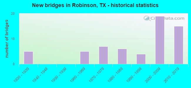
- New bridges - historical statistics
- 51930-1939
- 51960-1969
- 71970-1979
- 61980-1989
- 41990-1999
- 192000-2009
- 152010-2019

- Reconstructed bridges - Historical Statistics
- 11950-1959
- 01960-1969
- 11970-1979
- 31980-1989
- 01990-1999
- 22000-2009
- 12010-2019


- Bridge Condition - Deck
- 5.4%Very good
- 78.4%Good
- 16.2%Satisfactory

- Bridge Condition - Superstructure
- 5.4%Very good
- 62.2%Good
- 32.4%Satisfactory

- Bridge Condition - Substructure
- 62.2%Good
- 32.4%Satisfactory
- 5.4%Fair

- Bridge Condition - Channel
- 2.6%Very good
- 35.9%Good
- 46.2%Satisfactory
- 12.8%Fair
- 2.6%Poor

- Bridge Condition - Culverts
- 61.5%Good
- 23.1%Satisfactory
- 15.4%Fair
Find on map >> Show street view
Structure Number: 91610001501065, Location: 2.2 Mi S of LP 396 (Lat: 31.494178, Lng: -97.153975), Route carried "on" structure: Ramp State highway 6, Year Built: 2007, Status: Open, Structure Length: 79.16m (259.71ft), Average Daily Traffic: 14,065 (year 2017), Truck Traffic: 31%, Average Future Daily Traffic: 19,690 (year 2037), Design Load: HS 25 or greater, Features Intersected: IH 35 & LP 340(SH 6), Facility Carried by Structure: LP340EB-IH35NBConn
Minimum Vertical Clearance: 7.64m (25.07ft), Kilometerpoint: 34.496, Lanes on structure: 1, Lanes under structure: 20, Base Highway Network: Yes, Owner: State Highway Agency, Approaching Roadway Width: 11.6m (38.1ft), Material/Design: Steel continuous, Design/Construction: Box Beam or Girders - Multiple, Number Of Spans In Main Unit: 6, Number Of Approach Spans: 14, Length of Maximum Span: 65.5m (214.9ft), Curb-To-Curb Width: 11.0m (36.1ft), Out-to-Out Width: 11.6m (38.1ft)
Condition: Deck: Good, Superstructure: Good, Substructure: Good, Operating Rating: 68.0 metric tons, Method Used To Determine Operating Rating: Assigned rating based on Load Factor Design (LFD) reported in metric tons, Inventory Rating: 40.8 metric tons, Method Used To Determine Inventory Rating: Assigned rating based on Load Factor Design (LFD) reported in metric tons, Structural Evaluation: Better than present minimum criteria, Deck Geometry: Superior to present desirable criteria, Underclear: Equal to present minimum criteria, Approach Roadway Alignment: Equal to present minimum criteria, Designated Inspection Frequency: Every 24 months, Inspection Date: March 2021, Deck Structure Type: Corrugated Steel, Wearing Surface/Protective System: Wearing Surface: Monolithic Concrete
Find on map >> Show street view
Structure Number: 91610001501099, Location: 2.4 Mi S of LP 396 (Lat: 31.492972, Lng: -97.151967), Route carried "on" structure: ServiceState highway 6, Year Built: 2006, Status: Open, Structure Length: 14.02m (46.00ft), Average Daily Traffic: 20,790 (year 2013), Truck Traffic: 7%, Average Future Daily Traffic: 29,110 (year 2033), Design Load: HL 93, Features Intersected: IH 35
Minimum Vertical Clearance: 30+ m (98+ ft), Kilometerpoint: 17.692, Lanes on structure: 3, Lanes under structure: 14, Base Highway Network: Yes, Owner: State Highway Agency, Approaching Roadway Width: 14.0m (45.9ft), Material/Design: Prestressed concrete, Design/Construction: Stringer/Multi-beam, Number Of Spans In Main Unit: 4, Length of Maximum Span: 35.1m (115.2ft), Curb-To-Curb Width: 13.8m (45.3ft), Out-to-Out Width: 14.7m (48.2ft)
Condition: Deck: Good, Superstructure: Good, Substructure: Good, Operating Rating: 54.4 metric tons, Method Used To Determine Operating Rating: Assigned ratings based on Load and Resistance Factor Design (LRFD) reported in metric tons, Inventory Rating: 32.7 metric tons, Method Used To Determine Inventory Rating: Assigned ratings based on Load and Resistance Factor Design (LRFD) reported in metric tons, Structural Evaluation: Better than present minimum criteria, Deck Geometry: Somewhat better than minimum adequacy, Underclear: Meets minimum limits, Approach Roadway Alignment: Equal to present desirable criteria, Designated Inspection Frequency: Every 24 months, Inspection Date: Febuary 2021, Deck Structure Type: Concrete Cast-file-Place
Find on map >> Show street view
Structure Number: 91610001501278, Location: 2.4 Mi S of LP 396 (Lat: 31.493331, Lng: -97.151744), Route carried "on" structure: State highway 6, Year Built: 2006, Status: Open, Structure Length: 14.02m (46.00ft), Average Daily Traffic: 16,060 (year 2013), Truck Traffic: 8%, Average Future Daily Traffic: 22,480 (year 2033), Design Load: HL 93, Features Intersected: IH 35
Minimum Vertical Clearance: 7.42m (24.34ft), Kilometerpoint: 35.325, Lanes on structure: 2, Lanes under structure: 14, Base Highway Network: Yes, Owner: State Highway Agency, Approaching Roadway Width: 17.1m (56.1ft), Material/Design: Prestressed concrete, Design/Construction: Stringer/Multi-beam, Number Of Spans In Main Unit: 4, Length of Maximum Span: 35.1m (115.2ft), Curb-To-Curb Width: 16.9m (55.4ft), Out-to-Out Width: 17.8m (58.4ft)
Condition: Deck: Good, Superstructure: Good, Substructure: Good, Operating Rating: 54.4 metric tons, Method Used To Determine Operating Rating: Assigned ratings based on Load and Resistance Factor Design (LRFD) reported in metric tons, Inventory Rating: 32.7 metric tons, Method Used To Determine Inventory Rating: Assigned ratings based on Load and Resistance Factor Design (LRFD) reported in metric tons, Structural Evaluation: Better than present minimum criteria, Deck Geometry: Superior to present desirable criteria, Underclear: Meets minimum limits, Approach Roadway Alignment: Equal to present desirable criteria, Designated Inspection Frequency: Every 24 months, Inspection Date: Febuary 2021, Deck Structure Type: Concrete Cast-file-Place
Find on map >> Show street view
Structure Number: 9161000150128, Location: 2.4 Mi S of LP 396 (Lat: 31.494011, Lng: -97.151328), Route carried "on" structure: ServiceState highway 6, Year Built: 2006, Status: Open, Structure Length: 14.02m (46.00ft), Average Daily Traffic: 10,000 (year 2011), Truck Traffic: 9%, Average Future Daily Traffic: 14,200 (year 2031), Design Load: HL 93, Features Intersected: IH 35
Minimum Vertical Clearance: 8.18m (26.84ft), Kilometerpoint: 17.859, Lanes on structure: 3, Lanes under structure: 14, Base Highway Network: Yes, Owner: State Highway Agency, Approaching Roadway Width: 14.0m (45.9ft), Material/Design: Prestressed concrete, Design/Construction: Stringer/Multi-beam, Number Of Spans In Main Unit: 4, Length of Maximum Span: 35.1m (115.2ft), Curb-To-Curb Width: 13.8m (45.3ft), Out-to-Out Width: 14.7m (48.2ft)
Condition: Deck: Good, Superstructure: Good, Substructure: Good, Operating Rating: 54.4 metric tons, Method Used To Determine Operating Rating: Assigned ratings based on Load and Resistance Factor Design (LRFD) reported in metric tons, Inventory Rating: 32.7 metric tons, Method Used To Determine Inventory Rating: Assigned ratings based on Load and Resistance Factor Design (LRFD) reported in metric tons, Structural Evaluation: Better than present minimum criteria, Deck Geometry: Meets minimum limits, Underclear: Meets minimum limits, Approach Roadway Alignment: Equal to present desirable criteria, Designated Inspection Frequency: Every 24 months, Inspection Date: Febuary 2021, Deck Structure Type: Concrete Cast-file-Place
Find on map >> Show street view
Structure Number: 91610001501355, Location: 2.3 Mi S of LP 396 (Lat: 31.492756, Lng: -97.150397), Route carried "on" structure: State highway 6, Year Built: 2006, Status: Open, Structure Length: 14.02m (46.00ft), Average Daily Traffic: 24,311 (year 2017), Truck Traffic: 7%, Average Future Daily Traffic: 34,040 (year 2037), Design Load: HL 93, Features Intersected: IH 35
Minimum Vertical Clearance: 7.42m (24.34ft), Kilometerpoint: 17.791, Lanes on structure: 2, Lanes under structure: 14, Base Highway Network: Yes, Owner: State Highway Agency, Approaching Roadway Width: 17.1m (56.1ft), Material/Design: Prestressed concrete, Design/Construction: Stringer/Multi-beam, Number Of Spans In Main Unit: 4, Length of Maximum Span: 35.1m (115.2ft), Curb-To-Curb Width: 16.9m (55.4ft), Out-to-Out Width: 17.8m (58.4ft)
Condition: Deck: Good, Superstructure: Good, Substructure: Good, Operating Rating: 54.4 metric tons, Method Used To Determine Operating Rating: Assigned ratings based on Load and Resistance Factor Design (LRFD) reported in metric tons, Inventory Rating: 32.7 metric tons, Method Used To Determine Inventory Rating: Assigned ratings based on Load and Resistance Factor Design (LRFD) reported in metric tons, Structural Evaluation: Better than present minimum criteria, Deck Geometry: Superior to present desirable criteria, Underclear: Meets minimum limits, Approach Roadway Alignment: Equal to present desirable criteria, Designated Inspection Frequency: Every 24 months, Inspection Date: Febuary 2021, Deck Structure Type: Concrete Cast-file-Place
Find on map >> Show street view
Structure Number: 91610001501512, Location: 1.7 Mi S of LP 340 (Lat: 31.471411, Lng: -97.164100), Route carried "on" structure: Interstate 35, Year Built: 2011, Status: Open, Structure Length: 10.52m (34.51ft), Average Daily Traffic: 39,255 (year 2017), Truck Traffic: 33%, Average Future Daily Traffic: 54,470 (year 2037), Design Load: HL 93, Features Intersected: Crossover Rd
Minimum Vertical Clearance: 30+ m (98+ ft), Kilometerpoint: 15.072, Lanes on structure: 4, Lanes under structure: 6, Base Highway Network: Yes, Owner: State Highway Agency, Approaching Roadway Width: 21.0m (68.9ft), Material/Design: Prestressed concrete, Design/Construction: Stringer/Multi-beam, Number Of Spans In Main Unit: 3, Length of Maximum Span: 35.1m (115.2ft), Curb-To-Curb Width: 21.0m (68.9ft), Out-to-Out Width: 21.9m (71.9ft)
Condition: Deck: Good, Superstructure: Good, Substructure: Good, Operating Rating: 54.4 metric tons, Method Used To Determine Operating Rating: Assigned ratings based on Load and Resistance Factor Design (LRFD) reported in metric tons, Inventory Rating: 32.7 metric tons, Method Used To Determine Inventory Rating: Assigned ratings based on Load and Resistance Factor Design (LRFD) reported in metric tons, Structural Evaluation: Better than present minimum criteria, Deck Geometry: Better than present minimum criteria, Underclear: Superior to present desirable criteria, Approach Roadway Alignment: Equal to present desirable criteria, Designated Inspection Frequency: Every 24 months, Inspection Date: Febuary 2021, Deck Structure Type: Concrete Cast-file-Place
Find on map >> Show street view
Structure Number: 91610001501515, Location: 2.4 Mi NW of FM 2063 (Lat: 31.488350, Lng: -97.153389), Route carried "on" structure: Ramp Interstate 35, Year Built: 2012, Status: Open, Structure Length: 113.48m (372.31ft), Average Daily Traffic: 71,020 (year 2013), Truck Traffic: 31%, Average Future Daily Traffic: 99,430 (year 2033), Design Load: HS 25 or greater, Features Intersected: IH 35 & SH 6/LP 340
Minimum Vertical Clearance: 30+ m (98+ ft), Kilometerpoint: 17.191, Lanes on structure: 1, Lanes under structure: 22, Owner: State Highway Agency, Approaching Roadway Width: 7.9m (25.9ft), Material/Design: Steel continuous, Design/Construction: Box Beam or Girders - Multiple, Number Of Spans In Main Unit: 5, Number Of Approach Spans: 25, Length of Maximum Span: 74.1m (243.1ft), Curb-To-Curb Width: 7.9m (25.9ft), Out-to-Out Width: 8.5m (27.9ft)
Condition: Deck: Satisfactory, Superstructure: Satisfactory, Substructure: Good, Operating Rating: 55.3 metric tons, Method Used To Determine Operating Rating: Assigned rating based on Load Factor Design (LFD) reported in metric tons, Inventory Rating: 40.8 metric tons, Method Used To Determine Inventory Rating: Assigned rating based on Load Factor Design (LFD) reported in metric tons, Structural Evaluation: Equal to present minimum criteria, Deck Geometry: Equal to present desirable criteria, Underclear: Equal to present minimum criteria, Approach Roadway Alignment: Equal to present desirable criteria, Designated Inspection Frequency: Every 24 months, Critical Feature Inspection Frequency: Every 24 months, Inspection Date: Febuary 2021, Critical Feature Inspection Date: September 2021, Deck Structure Type: Concrete Cast-file-Place
Find on map >> Show street view
Structure Number: 91610001501516, Location: 1.7 mi S of SH 6 (Lat: 31.470775, Lng: -97.164656), Route carried "on" structure: Interstate 35, Year Built: 2011, Status: Open, Structure Length: 1.37m (4.49ft), Average Daily Traffic: 67,192 (year 2020), Truck Traffic: 19%, Average Future Daily Traffic: 91,030 (year 2033), Design Load: HS 20, Features Intersected: Crow Creek
Minimum Vertical Clearance: 30+ m (98+ ft), Kilometerpoint: 14.960, Lanes on structure: 13, Owner: State Highway Agency, Approaching Roadway Width: 72.2m (236.9ft), Skew: 39 degrees, Material/Design: Concrete, Design/Construction: Culvert, Number Of Spans In Main Unit: 5, Length of Maximum Span: 2.7m (8.9ft)
Condition: Channel: Good, Culverts: Good, Operating Rating: 54.4 metric tons, Method Used To Determine Operating Rating: Assigned rating based on Load Factor Design (LFD) reported in metric tons, Inventory Rating: 32.7 metric tons, Method Used To Determine Inventory Rating: Assigned rating based on Load Factor Design (LFD) reported in metric tons, Structural Evaluation: Better than present minimum criteria, Waterway Adequacy: Equal to present minimum criteria, Approach Roadway Alignment: Equal to present desirable criteria, Designated Inspection Frequency: Every 48 months, Inspection Date: April 2021
Find on map >> Show street view
Structure Number: 91610001501517, Location: 1.20 Mi SW of SH 6 (Lat: 31.477289, Lng: -97.160744), Route carried "on" structure: Interstate 35, Year Built: 2011, Status: Open, Structure Length: 1.92m (6.30ft), Average Daily Traffic: 67,192 (year 2020), Truck Traffic: 19%, Average Future Daily Traffic: 91,030 (year 2033), Design Load: HS 20, Features Intersected: Flat Creek
Minimum Vertical Clearance: 30+ m (98+ ft), Kilometerpoint: 157.748, Lanes on structure: 12, Owner: State Highway Agency, Approaching Roadway Width: 67.1m (220.1ft), Skew: 39 degrees, Material/Design: Concrete, Design/Construction: Culvert, Number Of Spans In Main Unit: 5, Length of Maximum Span: 3.0m (9.8ft)
Condition: Channel: Good, Culverts: Good, Operating Rating: 54.4 metric tons, Method Used To Determine Operating Rating: Assigned rating based on Load Factor Design (LFD) reported in metric tons, Inventory Rating: 32.7 metric tons, Method Used To Determine Inventory Rating: Assigned rating based on Load Factor Design (LFD) reported in metric tons, Structural Evaluation: Better than present minimum criteria, Waterway Adequacy: Equal to present minimum criteria, Approach Roadway Alignment: Equal to present desirable criteria, Designated Inspection Frequency: Every 48 months, Inspection Date: December 2020
Find on map >> Show street view
Structure Number: 91610001501518, Location: 0.70 Mi SW of SH 6 (Lat: 31.483494, Lng: -97.156364), Route carried "on" structure: Interstate 35, Year Built: 2011, Status: Open, Structure Length: 1.46m (4.79ft), Average Daily Traffic: 67,192 (year 2020), Truck Traffic: 19%, Average Future Daily Traffic: 91,030 (year 2033), Design Load: HS 20, Features Intersected: N Flat Creek
Minimum Vertical Clearance: 30+ m (98+ ft), Kilometerpoint: 16.557, Lanes on structure: 10, Owner: State Highway Agency, Approaching Roadway Width: 56.1m (184.1ft), Skew: 39 degrees, Material/Design: Concrete, Design/Construction: Culvert, Number Of Spans In Main Unit: 4, Length of Maximum Span: 3.0m (9.8ft)
Condition: Channel: Satisfactory, Culverts: Satisfactory, Operating Rating: 54.4 metric tons, Method Used To Determine Operating Rating: Assigned rating based on Load Factor Design (LFD) reported in metric tons, Inventory Rating: 32.7 metric tons, Method Used To Determine Inventory Rating: Assigned rating based on Load Factor Design (LFD) reported in metric tons, Structural Evaluation: Equal to present minimum criteria, Waterway Adequacy: Equal to present minimum criteria, Approach Roadway Alignment: Equal to present desirable criteria, Designated Inspection Frequency: Every 48 months, Inspection Date: December 2020
Find on map >> Show street view
Structure Number: 91610001501671, Location: 1.7 Mi S of LP 340 (Lat: 31.471933, Lng: -97.164017), Route carried "on" structure: Interstate 35, Year Built: 2011, Status: Open, Structure Length: 10.52m (34.51ft), Average Daily Traffic: 38,556 (year 2017), Truck Traffic: 33%, Average Future Daily Traffic: 54,470 (year 2037), Design Load: HL 93, Features Intersected: Crossover Rd
Minimum Vertical Clearance: 30+ m (98+ ft), Kilometerpoint: 15.072, Lanes on structure: 3, Lanes under structure: 6, Base Highway Network: Yes, Owner: State Highway Agency, Approaching Roadway Width: 18.6m (61.0ft), Material/Design: Prestressed concrete, Design/Construction: Stringer/Multi-beam, Number Of Spans In Main Unit: 3, Length of Maximum Span: 35.1m (115.2ft), Curb-To-Curb Width: 18.5m (60.7ft), Out-to-Out Width: 19.4m (63.6ft)
Condition: Deck: Satisfactory, Superstructure: Good, Substructure: Good, Operating Rating: 54.4 metric tons, Method Used To Determine Operating Rating: Assigned ratings based on Load and Resistance Factor Design (LRFD) reported in metric tons, Inventory Rating: 32.7 metric tons, Method Used To Determine Inventory Rating: Assigned ratings based on Load and Resistance Factor Design (LRFD) reported in metric tons, Structural Evaluation: Better than present minimum criteria, Deck Geometry: Superior to present desirable criteria, Underclear: Superior to present desirable criteria, Approach Roadway Alignment: Equal to present desirable criteria, Designated Inspection Frequency: Every 24 months, Inspection Date: Febuary 2021, Deck Structure Type: Concrete Cast-file-Place
Find on map >> Show street view
Structure Number: 91610001502608, Location: 0.3 Mi S of FM 2063 (Lat: 31.454350, Lng: -97.173942), Route carried "on" structure: Interstate 35, Year Built: 2015, Status: Open, Structure Length: 0.79m (2.59ft), Average Daily Traffic: 65,120 (year 2011), Truck Traffic: 28%, Average Future Daily Traffic: 91,170 (year 2031), Design Load: HL 93, Features Intersected: Tributary of Chambers Ck
Minimum Vertical Clearance: 30+ m (98+ ft), Kilometerpoint: 9.249, Lanes on structure: 5, Owner: State Highway Agency, Approaching Roadway Width: 52.4m (171.9ft), Skew: 34 degrees, Material/Design: Concrete, Design/Construction: Culvert, Number Of Spans In Main Unit: 2, Length of Maximum Span: 3.4m (11.2ft)
Condition: Channel: Very good, Culverts: Good, Operating Rating: 54.4 metric tons, Method Used To Determine Operating Rating: Assigned ratings based on Load and Resistance Factor Design (LRFD) reported in metric tons, Inventory Rating: 32.7 metric tons, Method Used To Determine Inventory Rating: Assigned ratings based on Load and Resistance Factor Design (LRFD) reported in metric tons, Structural Evaluation: Better than present minimum criteria, Waterway Adequacy: Equal to present desirable criteria, Approach Roadway Alignment: Equal to present desirable criteria, Designated Inspection Frequency: Every 48 months, Inspection Date: Febuary 2021
Find on map >> Show street view
Structure Number: 91610020901003, Location: 0.2 Mi N of LP 340 (Lat: 31.501775, Lng: -97.125656), Route carried "on" structure: US 77, Year Built: 1931, Year Reconstructed: 1984, Status: Open, Structure Length: 2.42m (7.94ft), Average Daily Traffic: 14,013 (year 2020), Truck Traffic: 10%, Average Future Daily Traffic: 21,010 (year 2037), Features Intersected: Cottonwood Creek
Minimum Vertical Clearance: 30+ m (98+ ft), Kilometerpoint: 6.568, Lanes on structure: 6, Base Highway Network: Yes, Owner: State Highway Agency, Approaching Roadway Width: 26.8m (87.9ft), Material/Design: Concrete, Design/Construction: Tee Beam, Number Of Spans In Main Unit: 3, Length of Maximum Span: 8.1m (26.6ft), Curb-To-Curb Width: 27.1m (88.9ft), Out-to-Out Width: 27.7m (90.9ft)
Condition: Deck: Good, Superstructure: Good, Substructure: Satisfactory, Channel: Satisfactory, Operating Rating: 50.8 metric tons, Method Used To Determine Operating Rating: Load Factor (LF), Inventory Rating: 30.8 metric tons, Method Used To Determine Inventory Rating: Load Factor (LF), Structural Evaluation: Equal to present minimum criteria, Deck Geometry: Better than present minimum criteria, Waterway Adequacy: Equal to present minimum criteria, Approach Roadway Alignment: Equal to present desirable criteria, Length Of Structure Improvement: 3.05m (10.01ft), Designated Inspection Frequency: Every 24 months, Inspection Date: Febuary 2021, Bridge Improvement Cost: $300,000, Roadway Improvement Cost: $100,000, Total Project Cost: $500,000, Deck Structure Type: Concrete Cast-file-Place, Wearing Surface/Protective System: Wearing Surface: Bituminous
Find on map >> Show street view
Structure Number: 91610020901005, Location: 5.5 Mi N of FM 2643 (Lat: 31.474386, Lng: -97.118261), Route carried "on" structure: US 77, Year Built: 1931, Year Reconstructed: 1991, Status: Open, Structure Length: 3.23m (10.60ft), Average Daily Traffic: 21,161 (year 2020), Truck Traffic: 9%, Average Future Daily Traffic: 26,850 (year 2037), Features Intersected: Flat Creek
Minimum Vertical Clearance: 30+ m (98+ ft), Kilometerpoint: 9.679, Lanes on structure: 5, Base Highway Network: Yes, Owner: State Highway Agency, Approaching Roadway Width: 25.0m (82.0ft), Material/Design: Concrete, Design/Construction: Tee Beam, Number Of Spans In Main Unit: 4, Length of Maximum Span: 7.9m (25.9ft), Curb or Sidewalk Widths: Left: 1.5m (4.9ft), Right: 1.5m (4.9ft), Curb-To-Curb Width: 25.0m (82.0ft), Out-to-Out Width: 29.2m (95.8ft)
Condition: Deck: Good, Superstructure: Satisfactory, Substructure: Satisfactory, Channel: Satisfactory, Operating Rating: 52.6 metric tons, Method Used To Determine Operating Rating: Load Factor (LF), Inventory Rating: 31.7 metric tons, Method Used To Determine Inventory Rating: Load Factor (LF), Structural Evaluation: Equal to present minimum criteria, Deck Geometry: Superior to present desirable criteria, Waterway Adequacy: Equal to present minimum criteria, Approach Roadway Alignment: Equal to present desirable criteria, Length Of Structure Improvement: 4.57m (14.99ft), Designated Inspection Frequency: Every 24 months, Inspection Date: Febuary 2021, Bridge Improvement Cost: $500,000, Roadway Improvement Cost: $200,000, Total Project Cost: $900,000, Deck Structure Type: Concrete Cast-file-Place, Wearing Surface/Protective System: Wearing Surface: Bituminous
Find on map >> Show street view
Structure Number: 91610020901009, Location: 0.4 Mi N of FM 2643 (Lat: 31.401872, Lng: -97.094381), Route carried "on" structure: US 77, Year Built: 1931, Year Reconstructed: 1958, Status: Open, Structure Length: 2.41m (7.91ft), Average Daily Traffic: 7,515 (year 2020), Truck Traffic: 13%, Average Future Daily Traffic: 10,940 (year 2037), Features Intersected: Dry Creek
Minimum Vertical Clearance: 30+ m (98+ ft), Kilometerpoint: 18.065, Lanes on structure: 2, Base Highway Network: Yes, Owner: State Highway Agency, Approaching Roadway Width: 13.4m (44.0ft), Material/Design: Concrete, Design/Construction: Tee Beam, Number Of Spans In Main Unit: 3, Length of Maximum Span: 7.9m (25.9ft), Curb-To-Curb Width: 13.4m (44.0ft), Out-to-Out Width: 13.8m (45.3ft)
Condition: Deck: Satisfactory, Superstructure: Good, Substructure: Satisfactory, Channel: Satisfactory, Operating Rating: 50.8 metric tons, Method Used To Determine Operating Rating: Load Factor (LF), Inventory Rating: 30.8 metric tons, Method Used To Determine Inventory Rating: Load Factor (LF), Structural Evaluation: Equal to present minimum criteria, Deck Geometry: Equal to present minimum criteria, Waterway Adequacy: Equal to present minimum criteria, Approach Roadway Alignment: Equal to present desirable criteria, Length Of Structure Improvement: 3.05m (10.01ft), Designated Inspection Frequency: Every 24 months, Inspection Date: Febuary 2021, Bridge Improvement Cost: $300,000, Roadway Improvement Cost: $100,000, Total Project Cost: $500,000, Deck Structure Type: Concrete Cast-file-Place, Wearing Surface/Protective System: Wearing Surface: Bituminous
Find on map >> Show street view
Structure Number: 91610020901072, Location: 2.7 Mi N of FM 2643 (Lat: 31.435792, Lng: -97.105392), Route carried "on" structure: US 77, Year Built: 2004, Status: Open, Structure Length: 3.50m (11.48ft), Average Daily Traffic: 8,273 (year 2020), Truck Traffic: 12%, Average Future Daily Traffic: 11,700 (year 2037), Design Load: HS 20, Features Intersected: Castleman Creek
Minimum Vertical Clearance: 30+ m (98+ ft), Kilometerpoint: 14.173, Lanes on structure: 5, Base Highway Network: Yes, Owner: State Highway Agency, Approaching Roadway Width: 25.3m (83.0ft), Material/Design: Prestressed concrete, Design/Construction: Stringer/Multi-beam, Number Of Spans In Main Unit: 1, Length of Maximum Span: 35.0m (114.8ft), Curb-To-Curb Width: 25.2m (82.7ft), Out-to-Out Width: 25.8m (84.6ft)
Condition: Deck: Good, Superstructure: Good, Substructure: Good, Channel: Good, Operating Rating: 54.4 metric tons, Method Used To Determine Operating Rating: Assigned rating based on Load Factor Design (LFD) reported in metric tons, Inventory Rating: 32.7 metric tons, Method Used To Determine Inventory Rating: Assigned rating based on Load Factor Design (LFD) reported in metric tons, Structural Evaluation: Better than present minimum criteria, Deck Geometry: Superior to present desirable criteria, Waterway Adequacy: Superior to present desirable criteria, Approach Roadway Alignment: Equal to present desirable criteria, Designated Inspection Frequency: Every 24 months, Inspection Date: Febuary 2021, Deck Structure Type: Concrete Cast-file-Place, Wearing Surface/Protective System: Wearing Surface: Bituminous
Find on map >> Show street view
Structure Number: 91610020901073, Location: 2.6 Mi N of FM 2643 (Lat: 31.434153, Lng: -97.104833), Route carried "on" structure: US 77, Year Built: 2004, Status: Open, Structure Length: 2.80m (9.19ft), Average Daily Traffic: 8,273 (year 2020), Truck Traffic: 12%, Average Future Daily Traffic: 11,700 (year 2037), Design Load: HS 20, Features Intersected: Castleman Creek Relief
Minimum Vertical Clearance: 30+ m (98+ ft), Kilometerpoint: 14.328, Lanes on structure: 5, Base Highway Network: Yes, Owner: State Highway Agency, Approaching Roadway Width: 25.2m (82.7ft), Material/Design: Prestressed concrete, Design/Construction: Stringer/Multi-beam, Number Of Spans In Main Unit: 1, Length of Maximum Span: 28.0m (91.9ft), Curb-To-Curb Width: 25.2m (82.7ft), Out-to-Out Width: 25.8m (84.6ft)
Condition: Deck: Good, Superstructure: Good, Substructure: Good, Channel: Good, Operating Rating: 54.4 metric tons, Method Used To Determine Operating Rating: Assigned rating based on Load Factor Design (LFD) reported in metric tons, Inventory Rating: 32.7 metric tons, Method Used To Determine Inventory Rating: Assigned rating based on Load Factor Design (LFD) reported in metric tons, Structural Evaluation: Better than present minimum criteria, Deck Geometry: Superior to present desirable criteria, Waterway Adequacy: Superior to present desirable criteria, Approach Roadway Alignment: Equal to present desirable criteria, Designated Inspection Frequency: Every 24 months, Inspection Date: Febuary 2021, Deck Structure Type: Concrete Precast Panels
Find on map >> Show street view
Structure Number: 91610020901074, Location: 0.4 Mi N of FM 2837 (Lat: 31.422872, Lng: -97.101192), Route carried "on" structure: US 77, Year Built: 2004, Status: Open, Structure Length: 1.28m (4.20ft), Average Daily Traffic: 8,273 (year 2020), Truck Traffic: 12%, Average Future Daily Traffic: 11,580 (year 2033), Design Load: HS 20, Features Intersected: Br Castleman Creek
Minimum Vertical Clearance: 30+ m (98+ ft), Kilometerpoint: 15.638, Lanes on structure: 5, Owner: State Highway Agency, Approaching Roadway Width: 26.2m (86.0ft), Material/Design: Concrete, Design/Construction: Culvert, Number Of Spans In Main Unit: 4, Length of Maximum Span: 3.0m (9.8ft)
Condition: Channel: Satisfactory, Culverts: Good, Operating Rating: 54.4 metric tons, Method Used To Determine Operating Rating: Assigned rating based on Load Factor Design (LFD) reported in metric tons, Inventory Rating: 32.7 metric tons, Method Used To Determine Inventory Rating: Assigned rating based on Load Factor Design (LFD) reported in metric tons, Structural Evaluation: Better than present minimum criteria, Waterway Adequacy: Equal to present desirable criteria, Approach Roadway Alignment: Equal to present desirable criteria, Designated Inspection Frequency: Every 48 months, Inspection Date: March 2021
Find on map >> Show street view
Structure Number: 91610020901091, Location: 1.7 Mi E of IH 35 (Lat: 31.498406, Lng: -97.124958), Route carried "on" structure: US 77, Year Built: 1984, Status: Open, Structure Length: 8.72m (28.61ft), Average Daily Traffic: 20,245 (year 2020), Truck Traffic: 13%, Average Future Daily Traffic: 18,590 (year 2033), Design Load: HS 20, Features Intersected: SH 6 (LP 340)
Minimum Vertical Clearance: 30+ m (98+ ft), Kilometerpoint: 6.854, Lanes on structure: 7, Lanes under structure: 6, Base Highway Network: Yes, Owner: State Highway Agency, Approaching Roadway Width: 27.1m (88.9ft), Skew: 1 degrees, Material/Design: Prestressed concrete continuous, Design/Construction: Stringer/Multi-beam, Number Of Spans In Main Unit: 2, Number Of Approach Spans: 2, Length of Maximum Span: 25.3m (83.0ft), Curb-To-Curb Width: 26.8m (87.9ft), Out-to-Out Width: 27.7m (90.9ft)
Condition: Deck: Good, Superstructure: Satisfactory, Substructure: Good, Operating Rating: 54.4 metric tons, Method Used To Determine Operating Rating: Assigned rating based on Load Factor Design (LFD) reported in metric tons, Inventory Rating: 32.7 metric tons, Method Used To Determine Inventory Rating: Assigned rating based on Load Factor Design (LFD) reported in metric tons, Structural Evaluation: Equal to present minimum criteria, Deck Geometry: Somewhat better than minimum adequacy, Underclear: Equal to present minimum criteria, Approach Roadway Alignment: Equal to present desirable criteria, Length Of Structure Improvement: 10.91m (35.79ft), Designated Inspection Frequency: Every 24 months, Inspection Date: Febuary 2021, Bridge Improvement Cost: $1,100,000, Roadway Improvement Cost: $300,000, Total Project Cost: $1,700,000, Deck Structure Type: Concrete Cast-file-Place, Wearing Surface/Protective System: Wearing Surface: Bituminous
Find on map >> Show street view
Structure Number: 91610025809083, Location: 0.3 Mi E IH 35 (Lat: 31.491147, Lng: -97.146706), Route carried "on" structure: State highway 6, Year Built: 1963, Year Reconstructed: 2016, Status: Open, Structure Length: 1.04m (3.41ft), Average Daily Traffic: 19,843 (year 2020), Truck Traffic: 8%, Average Future Daily Traffic: 34,040 (year 2037), Design Load: HS 20, Features Intersected: Trib Cottonwood Creek
Minimum Vertical Clearance: 30+ m (98+ ft), Kilometerpoint: 35.871, Lanes on structure: 8, Base Highway Network: Yes, Owner: State Highway Agency, Approaching Roadway Width: 36.6m (120.1ft), Skew: 9 degrees, Material/Design: Concrete, Design/Construction: Culvert, Number Of Spans In Main Unit: 3, Length of Maximum Span: 2.1m (6.9ft)
Condition: Channel: Good, Culverts: Good, Operating Rating: 39.9 metric tons, Method Used To Determine Operating Rating: Load Factor (LF), Inventory Rating: 23.6 metric tons, Method Used To Determine Inventory Rating: Load Factor (LF), Structural Evaluation: Somewhat better than minimum adequacy, Waterway Adequacy: Equal to present minimum criteria, Approach Roadway Alignment: Equal to present desirable criteria, Length Of Structure Improvement: 1.83m (6.00ft), Designated Inspection Frequency: Every 24 months, Inspection Date: Febuary 2021, Bridge Improvement Cost: $200,000, Roadway Improvement Cost: $100,000, Total Project Cost: $400,000
Find on map >> Show street view
Structure Number: 91610025809092, Location: 1.1 Mi E of US 77 (Lat: 31.506319, Lng: -97.108786), Route carried "on" structure: State highway 6, Year Built: 1984, Status: Open, Structure Length: 4.18m (13.71ft), Average Daily Traffic: 19,422 (year 2017), Truck Traffic: 8%, Average Future Daily Traffic: 23,700 (year 2037), Design Load: HS 20, Features Intersected: Cottonwood Creek
Minimum Vertical Clearance: 30+ m (98+ ft), Kilometerpoint: 39.934, Lanes on structure: 2, Base Highway Network: Yes, Owner: State Highway Agency, Approaching Roadway Width: 12.2m (40.0ft), Skew: 4 degrees, Material/Design: Concrete, Design/Construction: Stringer/Multi-beam, Number Of Spans In Main Unit: 4, Length of Maximum Span: 10.4m (34.1ft), Curb-To-Curb Width: 12.2m (40.0ft), Out-to-Out Width: 12.8m (42.0ft)
Condition: Deck: Good, Superstructure: Good, Substructure: Satisfactory, Channel: Satisfactory, Operating Rating: 68.9 metric tons, Method Used To Determine Operating Rating: Load Factor (LF), Inventory Rating: 40.8 metric tons, Method Used To Determine Inventory Rating: Load Factor (LF), Structural Evaluation: Equal to present minimum criteria, Deck Geometry: Better than present minimum criteria, Waterway Adequacy: Superior to present desirable criteria, Approach Roadway Alignment: Equal to present desirable criteria, Length Of Structure Improvement: 5.49m (18.01ft), Designated Inspection Frequency: Every 24 months, Inspection Date: Febuary 2021, Bridge Improvement Cost: $600,000, Roadway Improvement Cost: $200,000, Total Project Cost: $900,000, Deck Structure Type: Concrete Cast-file-Place, Wearing Surface/Protective System: Wearing Surface: Bituminous
Find on map >> Show street view
Structure Number: 91610025809099, Location: 1.1 Mi E of US 77 (Lat: 31.506256, Lng: -97.108447), Route carried "on" structure: State highway 6, Year Built: 2007, Status: Open, Structure Length: 4.17m (13.68ft), Average Daily Traffic: 19,422 (year 2017), Truck Traffic: 8%, Average Future Daily Traffic: 23,700 (year 2037), Design Load: HS 25 or greater, Features Intersected: Cottonwood Creek
Minimum Vertical Clearance: 30+ m (98+ ft), Kilometerpoint: 39.931, Lanes on structure: 2, Base Highway Network: Yes, Owner: State Highway Agency, Approaching Roadway Width: 12.2m (40.0ft), Skew: 4 degrees, Material/Design: Concrete, Design/Construction: Stringer/Multi-beam, Number Of Spans In Main Unit: 4, Length of Maximum Span: 10.4m (34.1ft), Curb-To-Curb Width: 11.2m (36.7ft), Out-to-Out Width: 12.2m (40.0ft)
Condition: Deck: Good, Superstructure: Satisfactory, Substructure: Satisfactory, Channel: Satisfactory, Operating Rating: 68.0 metric tons, Method Used To Determine Operating Rating: Assigned rating based on Load Factor Design (LFD) reported in metric tons, Inventory Rating: 40.8 metric tons, Method Used To Determine Inventory Rating: Assigned rating based on Load Factor Design (LFD) reported in metric tons, Structural Evaluation: Equal to present minimum criteria, Deck Geometry: Equal to present minimum criteria, Waterway Adequacy: Superior to present desirable criteria, Approach Roadway Alignment: Equal to present desirable criteria, Designated Inspection Frequency: Every 24 months, Inspection Date: Febuary 2021, Deck Structure Type: Concrete Cast-file-Place, Wearing Surface/Protective System: Wearing Surface: Bituminous
Find on map >> Show street view
Structure Number: 916100258091, Location: 1.1 Mi E of US 77 (Lat: 31.506456, Lng: -97.109261), Route carried "on" structure: ServiceState highway 6, Year Built: 2005, Status: Open, Structure Length: 4.18m (13.71ft), Average Daily Traffic: 24,311 (year 2017), Truck Traffic: 7%, Average Future Daily Traffic: 34,040 (year 2037), Design Load: HS 25 or greater, Features Intersected: Cottonwood Creek
Minimum Vertical Clearance: 30+ m (98+ ft), Kilometerpoint: 39.976, Lanes on structure: 3, Owner: State Highway Agency, Approaching Roadway Width: 12.2m (40.0ft), Skew: 4 degrees, Material/Design: Concrete, Design/Construction: Stringer/Multi-beam, Number Of Spans In Main Unit: 4, Length of Maximum Span: 10.4m (34.1ft), Curb-To-Curb Width: 11.8m (38.7ft), Out-to-Out Width: 12.8m (42.0ft)
Condition: Deck: Satisfactory, Superstructure: Satisfactory, Substructure: Good, Channel: Satisfactory, Operating Rating: 68.0 metric tons, Method Used To Determine Operating Rating: Assigned rating based on Load Factor Design (LFD) reported in metric tons, Inventory Rating: 40.8 metric tons, Method Used To Determine Inventory Rating: Assigned rating based on Load Factor Design (LFD) reported in metric tons, Structural Evaluation: Equal to present minimum criteria, Deck Geometry: High priority of corrective action, Waterway Adequacy: Superior to present desirable criteria, Approach Roadway Alignment: Equal to present desirable criteria, Designated Inspection Frequency: Every 24 months, Inspection Date: March 2021, Deck Structure Type: Concrete Cast-file-Place
Find on map >> Show street view
Structure Number: 91610025809101, Location: 1.1 Mi E of US 77 (Lat: 31.506158, Lng: -97.108128), Route carried "on" structure: ServiceState highway 6, Year Built: 2005, Status: Open, Structure Length: 4.18m (13.71ft), Average Daily Traffic: 577 (year 2017), Truck Traffic: 3%, Average Future Daily Traffic: 810 (year 2037), Design Load: HS 25 or greater, Features Intersected: Cottonwood Creek
Minimum Vertical Clearance: 30+ m (98+ ft), Kilometerpoint: 39.907, Lanes on structure: 2, Owner: State Highway Agency, Approaching Roadway Width: 8.5m (27.9ft), Skew: 4 degrees, Material/Design: Concrete, Design/Construction: Stringer/Multi-beam, Number Of Spans In Main Unit: 4, Length of Maximum Span: 10.4m (34.1ft), Curb-To-Curb Width: 8.2m (26.9ft), Out-to-Out Width: 9.0m (29.5ft)
Condition: Deck: Good, Superstructure: Good, Substructure: Good, Channel: Good, Operating Rating: 68.0 metric tons, Method Used To Determine Operating Rating: Assigned rating based on Load Factor Design (LFD) reported in metric tons, Inventory Rating: 40.8 metric tons, Method Used To Determine Inventory Rating: Assigned rating based on Load Factor Design (LFD) reported in metric tons, Structural Evaluation: Better than present minimum criteria, Deck Geometry: High priority of corrective action, Waterway Adequacy: Superior to present desirable criteria, Approach Roadway Alignment: Equal to present desirable criteria, Length Of Structure Improvement: 4.18m (13.71ft), Designated Inspection Frequency: Every 24 months, Inspection Date: Febuary 2021, Bridge Improvement Cost: $8,000, Roadway Improvement Cost: $2,000, Total Project Cost: $10,000, Deck Structure Type: Concrete Cast-file-Place, Wearing Surface/Protective System: Wearing Surface: Bituminous
Find on map >> Show street view
Structure Number: 91610025809452, Location: 1.1 Mi E of IH 35 (Lat: 31.494272, Lng: -97.133761), Route carried "on" structure: State highway 6, Year Built: 2018, Status: Open, Structure Length: 10.70m (35.10ft), Average Daily Traffic: 14,111 (year 2019), Truck Traffic: 8%, Average Future Daily Traffic: 16,990 (year 2037), Design Load: HL 93, Features Intersected: OLD ROBINSON ROAD
Minimum Vertical Clearance: 30+ m (98+ ft), Kilometerpoint: 0.000, Lanes on structure: 3, Lanes under structure: 6, Base Highway Network: Yes, Owner: State Highway Agency, Approaching Roadway Width: 15.2m (49.9ft), Skew: 2 degrees, Material/Design: Prestressed concrete, Design/Construction: Stringer/Multi-beam, Number Of Spans In Main Unit: 3, Length of Maximum Span: 40.2m (131.9ft), Curb-To-Curb Width: 15.1m (49.5ft), Out-to-Out Width: 15.9m (52.2ft)
Condition: Deck: Good, Superstructure: Good, Substructure: Good, Operating Rating: 54.4 metric tons, Method Used To Determine Operating Rating: Assigned ratings based on Load and Resistance Factor Design (LRFD) reported in metric tons, Inventory Rating: 32.7 metric tons, Method Used To Determine Inventory Rating: Assigned ratings based on Load and Resistance Factor Design (LRFD) reported in metric tons, Structural Evaluation: Better than present minimum criteria, Deck Geometry: Equal to present minimum criteria, Underclear: Superior to present desirable criteria, Approach Roadway Alignment: Equal to present desirable criteria, Designated Inspection Frequency: Every 24 months, Inspection Date: April 2021, Deck Structure Type: Concrete Precast Panels
Find on map >> Show street view
Structure Number: 91610025809453, Location: 1.1 Mi E of IH 35 (Lat: 31.495200, Lng: -97.132833), Route carried "on" structure: State highway 6, Year Built: 2018, Status: Open, Structure Length: 10.70m (35.10ft), Average Daily Traffic: 11,635 (year 2019), Truck Traffic: 8%, Average Future Daily Traffic: 16,990 (year 2037), Design Load: HL 93, Features Intersected: OLD ROBINSON ROAD
Minimum Vertical Clearance: 30+ m (98+ ft), Kilometerpoint: 0.000, Lanes on structure: 3, Lanes under structure: 6, Base Highway Network: Yes, Owner: State Highway Agency, Approaching Roadway Width: 15.2m (49.9ft), Skew: 2 degrees, Material/Design: Prestressed concrete, Design/Construction: Stringer/Multi-beam, Number Of Spans In Main Unit: 3, Length of Maximum Span: 40.2m (131.9ft), Curb-To-Curb Width: 15.1m (49.5ft), Out-to-Out Width: 15.9m (52.2ft)
Condition: Deck: Good, Superstructure: Good, Substructure: Good, Operating Rating: 54.4 metric tons, Method Used To Determine Operating Rating: Assigned ratings based on Load and Resistance Factor Design (LRFD) reported in metric tons, Inventory Rating: 32.7 metric tons, Method Used To Determine Inventory Rating: Assigned ratings based on Load and Resistance Factor Design (LRFD) reported in metric tons, Structural Evaluation: Better than present minimum criteria, Deck Geometry: Equal to present minimum criteria, Underclear: Superior to present desirable criteria, Approach Roadway Alignment: Equal to present desirable criteria, Designated Inspection Frequency: Every 24 months, Inspection Date: April 2021, Deck Structure Type: Concrete Precast Panels
Find on map >> Show street view
Structure Number: 91610083304051, Location: 1.1 Mi N of FM 2643 (Lat: 31.430547, Lng: -97.066717), Route carried "on" structure: State highway 434, Year Built: 2005, Status: Open, Structure Length: 5.49m (18.01ft), Average Daily Traffic: 1,961 (year 2020), Truck Traffic: 7%, Average Future Daily Traffic: 2,180 (year 2037), Design Load: HS 20, Features Intersected: Castlemans Creek
Minimum Vertical Clearance: 30+ m (98+ ft), Kilometerpoint: 17.727, Lanes on structure: 2, Owner: State Highway Agency, Approaching Roadway Width: 7.9m (25.9ft), Material/Design: Prestressed concrete, Design/Construction: Stringer/Multi-beam, Number Of Spans In Main Unit: 3, Length of Maximum Span: 24.4m (80.1ft), Curb-To-Curb Width: 13.4m (44.0ft), Out-to-Out Width: 14.0m (45.9ft)
Condition: Deck: Good, Superstructure: Very good, Substructure: Good, Channel: Good, Operating Rating: 44.4 metric tons, Method Used To Determine Operating Rating: Assigned rating based on Load Factor Design (LFD) reported in metric tons, Inventory Rating: 32.7 metric tons, Method Used To Determine Inventory Rating: Assigned rating based on Load Factor Design (LFD) reported in metric tons, Structural Evaluation: Better than present minimum criteria, Deck Geometry: Equal to present desirable criteria, Waterway Adequacy: Superior to present desirable criteria, Approach Roadway Alignment: Equal to present desirable criteria, Designated Inspection Frequency: Every 24 months, Inspection Date: December 2020, Deck Structure Type: Concrete Precast Panels
Find on map >> Show street view
Structure Number: 9161008331404, Location: 2.3 Mi S of FM 434 (Lat: 31.492131, Lng: -97.081097), Route carried "on" structure: State highway 3400, Year Built: 1982, Status: Open, Structure Length: 3.90m (12.80ft), Average Daily Traffic: 2,203 (year 2020), Truck Traffic: 7%, Average Future Daily Traffic: 3,020 (year 2033), Design Load: HS 20, Features Intersected: Flat Creek
Minimum Vertical Clearance: 30+ m (98+ ft), Kilometerpoint: 5.298, Lanes on structure: 2, Owner: State Highway Agency, Approaching Roadway Width: 11.0m (36.1ft), Skew: 2 degrees, Material/Design: Concrete, Design/Construction: Stringer/Multi-beam, Number Of Spans In Main Unit: 4, Length of Maximum Span: 9.8m (32.2ft), Curb-To-Curb Width: 12.2m (40.0ft), Out-to-Out Width: 12.9m (42.3ft)
Condition: Deck: Satisfactory, Superstructure: Satisfactory, Substructure: Fair, Channel: Fair, Operating Rating: 44.4 metric tons, Method Used To Determine Operating Rating: Assigned rating based on Load Factor Design (LFD) reported in metric tons, Inventory Rating: 32.7 metric tons, Method Used To Determine Inventory Rating: Assigned rating based on Load Factor Design (LFD) reported in metric tons, Structural Evaluation: Somewhat better than minimum adequacy, Deck Geometry: Equal to present minimum criteria, Waterway Adequacy: Equal to present minimum criteria, Approach Roadway Alignment: Equal to present desirable criteria, Length Of Structure Improvement: 5.03m (16.50ft), Designated Inspection Frequency: Every 24 months, Inspection Date: December 2020, Bridge Improvement Cost: $500,000, Roadway Improvement Cost: $100,000, Total Project Cost: $800,000, Deck Structure Type: Concrete Cast-file-Place, Wearing Surface/Protective System: Wearing Surface: Bituminous
Find on map >> Show street view
Structure Number: 91610083314041, Location: 2.4 Mi S of FM434 (N end) (Lat: 31.490239, Lng: -97.080481), Route carried "on" structure: State highway 3400, Year Built: 1982, Status: Open, Structure Length: 1.59m (5.22ft), Average Daily Traffic: 2,203 (year 2020), Truck Traffic: 7%, Average Future Daily Traffic: 3,020 (year 2033), Design Load: HS 20, Features Intersected: Flat Creek Relief
Minimum Vertical Clearance: 30+ m (98+ ft), Kilometerpoint: 5.544, Lanes on structure: 2, Owner: State Highway Agency, Approaching Roadway Width: 12.2m (40.0ft), Material/Design: Concrete, Design/Construction: Culvert, Number Of Spans In Main Unit: 6, Length of Maximum Span: 2.4m (7.9ft), Curb-To-Curb Width: 12.4m (40.7ft), Out-to-Out Width: 12.9m (42.3ft)
Condition: Channel: Good, Culverts: Satisfactory, Operating Rating: 39.9 metric tons, Method Used To Determine Operating Rating: Load Factor (LF), Inventory Rating: 23.6 metric tons, Method Used To Determine Inventory Rating: Load Factor (LF), Structural Evaluation: Equal to present minimum criteria, Deck Geometry: Equal to present minimum criteria, Waterway Adequacy: Equal to present minimum criteria, Approach Roadway Alignment: Equal to present desirable criteria, Length Of Structure Improvement: 2.74m (8.99ft), Designated Inspection Frequency: Every 48 months, Inspection Date: January 2021, Bridge Improvement Cost: $300,000, Roadway Improvement Cost: $100,000, Total Project Cost: $500,000, Deck Structure Type: Concrete Cast-file-Place, Wearing Surface/Protective System: Wearing Surface: Bituminous
Find on map >> Show street view
Structure Number: 91610107803006, Location: 1.4 Mi SE of US 77 (Lat: 31.405814, Lng: -97.071908), Route carried "on" structure: State highway 2643, Year Built: 1970, Status: Open, Structure Length: 3.11m (10.20ft), Average Daily Traffic: 728 (year 2020), Truck Traffic: 10%, Average Future Daily Traffic: 750 (year 2037), Design Load: H 15, Features Intersected: Dry Creek
Minimum Vertical Clearance: 30+ m (98+ ft), Kilometerpoint: 1.867, Lanes on structure: 2, Owner: State Highway Agency, Approaching Roadway Width: 6.7m (22.0ft), Skew: 4 degrees, Material/Design: Concrete, Design/Construction: Stringer/Multi-beam, Number Of Spans In Main Unit: 3, Length of Maximum Span: 10.4m (34.1ft), Curb-To-Curb Width: 7.9m (25.9ft), Out-to-Out Width: 8.6m (28.2ft)
Condition: Deck: Good, Superstructure: Good, Substructure: Satisfactory, Channel: Satisfactory, Operating Rating: 44.4 metric tons, Method Used To Determine Operating Rating: Load Factor (LF), Inventory Rating: 32.7 metric tons, Method Used To Determine Inventory Rating: Load Factor (LF), Structural Evaluation: Equal to present minimum criteria, Deck Geometry: Somewhat better than minimum adequacy, Waterway Adequacy: Better than present minimum criteria, Approach Roadway Alignment: Equal to present desirable criteria, Length Of Structure Improvement: 3.96m (12.99ft), Designated Inspection Frequency: Every 24 months, Inspection Date: December 2020, Bridge Improvement Cost: $500,000, Roadway Improvement Cost: $200,000, Total Project Cost: $800,000, Deck Structure Type: Concrete Cast-file-Place, Wearing Surface/Protective System: Wearing Surface: Bituminous
Find on map >> Show street view
Structure Number: 91610286801004, Location: 3.5 Mi E of IH 35 (Lat: 31.394497, Lng: -97.159244), Route carried "on" structure: State highway 2837, Year Built: 1965, Status: Open, Structure Length: 5.18m (16.99ft), Average Daily Traffic: 1,111 (year 2017), Truck Traffic: 17%, Average Future Daily Traffic: 1,430 (year 2037), Design Load: H 15, Features Intersected: Bullhide Creek
Minimum Vertical Clearance: 30+ m (98+ ft), Kilometerpoint: 21.588, Lanes on structure: 2, Owner: State Highway Agency, Approaching Roadway Width: 8.5m (27.9ft), Material/Design: Steel, Design/Construction: Stringer/Multi-beam, Number Of Spans In Main Unit: 5, Length of Maximum Span: 12.2m (40.0ft), Curb-To-Curb Width: 7.9m (25.9ft), Out-to-Out Width: 8.6m (28.2ft)
Condition: Deck: Good, Superstructure: Satisfactory, Substructure: Satisfactory, Channel: Satisfactory, Operating Rating: 39.0 metric tons, Method Used To Determine Operating Rating: Load Factor (LF), Inventory Rating: 22.7 metric tons, Method Used To Determine Inventory Rating: Load Factor (LF), Structural Evaluation: Equal to present minimum criteria, Deck Geometry: Meets minimum limits, Waterway Adequacy: Equal to present minimum criteria, Approach Roadway Alignment: Equal to present desirable criteria, Length Of Structure Improvement: 6.86m (22.51ft), Designated Inspection Frequency: Every 24 months, Inspection Date: December 2020, Bridge Improvement Cost: $900,000, Roadway Improvement Cost: $300,000, Total Project Cost: $1,400,000, Deck Structure Type: Concrete Cast-file-Place, Wearing Surface/Protective System: Wearing Surface: Bituminous
Find on map >> Show street view
Structure Number: 91610286801005, Location: 3.5 Mi E of IH 35 (Lat: 31.396872, Lng: -97.154078), Route carried "on" structure: State highway 2837, Year Built: 1965, Status: Open, Structure Length: 0.88m (2.89ft), Average Daily Traffic: 1,232 (year 2017), Truck Traffic: 18%, Average Future Daily Traffic: 1,730 (year 2037), Design Load: HS 20, Features Intersected: Tributary of Bullhide Ck
Minimum Vertical Clearance: 30+ m (98+ ft), Kilometerpoint: 22.491, Lanes on structure: 2, Owner: State Highway Agency, Approaching Roadway Width: 8.5m (27.9ft), Skew: 3 degrees, Material/Design: Concrete, Design/Construction: Culvert, Number Of Spans In Main Unit: 3, Length of Maximum Span: 2.4m (7.9ft), Curb-To-Curb Width: 8.7m (28.5ft), Out-to-Out Width: 15.9m (52.2ft)
Condition: Channel: Good, Culverts: Satisfactory, Operating Rating: 39.9 metric tons, Method Used To Determine Operating Rating: Load Factor (LF), Inventory Rating: 23.6 metric tons, Method Used To Determine Inventory Rating: Load Factor (LF), Structural Evaluation: Equal to present minimum criteria, Deck Geometry: Somewhat better than minimum adequacy, Waterway Adequacy: Equal to present minimum criteria, Approach Roadway Alignment: Equal to present desirable criteria, Length Of Structure Improvement: 1.83m (6.00ft), Designated Inspection Frequency: Every 24 months, Inspection Date: December 2020, Bridge Improvement Cost: $500,000, Roadway Improvement Cost: $200,000, Total Project Cost: $800,000, Deck Structure Type: Concrete Cast-file-Place, Wearing Surface/Protective System: Wearing Surface: Bituminous
Find on map >> Show street view
Structure Number: 91610286801006, Location: 1.9 Mi W of US 77 (Lat: 31.408719, Lng: -97.129539), Route carried "on" structure: State highway 2837, Year Built: 1965, Status: Open, Structure Length: 2.68m (8.79ft), Average Daily Traffic: 1,232 (year 2017), Truck Traffic: 18%, Average Future Daily Traffic: 1,730 (year 2037), Design Load: H 15, Features Intersected: Dry Creek
Minimum Vertical Clearance: 30+ m (98+ ft), Kilometerpoint: 25.149, Lanes on structure: 2, Owner: State Highway Agency, Approaching Roadway Width: 8.5m (27.9ft), Material/Design: Steel, Design/Construction: Stringer/Multi-beam, Number Of Spans In Main Unit: 3, Length of Maximum Span: 8.8m (28.9ft), Curb-To-Curb Width: 7.9m (25.9ft), Out-to-Out Width: 8.6m (28.2ft)
Condition: Deck: Good, Superstructure: Satisfactory, Substructure: Satisfactory, Channel: Satisfactory, Operating Rating: 52.6 metric tons, Method Used To Determine Operating Rating: Load Factor (LF), Inventory Rating: 31.7 metric tons, Method Used To Determine Inventory Rating: Load Factor (LF), Structural Evaluation: Equal to present minimum criteria, Deck Geometry: Meets minimum limits, Waterway Adequacy: Equal to present minimum criteria, Approach Roadway Alignment: Equal to present desirable criteria, Length Of Structure Improvement: 3.66m (12.01ft), Designated Inspection Frequency: Every 24 months, Inspection Date: December 2020, Bridge Improvement Cost: $500,000, Roadway Improvement Cost: $200,000, Total Project Cost: $800,000, Deck Structure Type: Concrete Cast-file-Place, Wearing Surface/Protective System: Wearing Surface: Bituminous
Find on map >> Show street view
Structure Number: 91610323301001, Location: 1.4 Mi E of IH 35 (Lat: 31.429364, Lng: -97.173961), Route carried "on" structure: State highway 3148, Year Built: 1973, Year Reconstructed: 2006, Status: Open, Structure Length: 2.93m (9.61ft), Average Daily Traffic: 3,472 (year 2020), Truck Traffic: 7%, Average Future Daily Traffic: 4,270 (year 2033), Design Load: H 15, Features Intersected: Castleman Creek
Minimum Vertical Clearance: 30+ m (98+ ft), Kilometerpoint: 36.114, Lanes on structure: 2, Owner: State Highway Agency, Approaching Roadway Width: 13.4m (44.0ft), Skew: 2 degrees, Material/Design: Concrete, Design/Construction: Stringer/Multi-beam, Number Of Spans In Main Unit: 3, Length of Maximum Span: 9.8m (32.2ft), Curb-To-Curb Width: 13.5m (44.3ft), Out-to-Out Width: 14.0m (45.9ft)
Condition: Deck: Good, Superstructure: Good, Substructure: Satisfactory, Channel: Fair, Operating Rating: 65.3 metric tons, Method Used To Determine Operating Rating: Load Factor (LF), Inventory Rating: 39.9 metric tons, Method Used To Determine Inventory Rating: Load Factor (LF), Structural Evaluation: Equal to present minimum criteria, Deck Geometry: Superior to present desirable criteria, Waterway Adequacy: Superior to present desirable criteria, Approach Roadway Alignment: Equal to present desirable criteria, Length Of Structure Improvement: 3.66m (12.01ft), Designated Inspection Frequency: Every 24 months, Inspection Date: Febuary 2021, Bridge Improvement Cost: $400,000, Roadway Improvement Cost: $100,000, Total Project Cost: $600,000, Deck Structure Type: Concrete Cast-file-Place, Wearing Surface/Protective System: Wearing Surface: Bituminous
Find on map >> Show street view
Structure Number: 91610323301002, Location: 2.6 Mi NE of IH 35 (Lat: 31.437658, Lng: -97.156117), Route carried "on" structure: State highway 3148, Year Built: 1973, Year Reconstructed: 2006, Status: Open, Structure Length: 2.77m (9.09ft), Average Daily Traffic: 3,077 (year 2020), Truck Traffic: 7%, Average Future Daily Traffic: 4,420 (year 2033), Design Load: H 15, Features Intersected: Chambers Creek
Minimum Vertical Clearance: 30+ m (98+ ft), Kilometerpoint: 38.026, Lanes on structure: 2, Owner: State Highway Agency, Approaching Roadway Width: 9.1m (29.9ft), Material/Design: Concrete, Design/Construction: Stringer/Multi-beam, Number Of Spans In Main Unit: 3, Length of Maximum Span: 9.1m (29.9ft), Curb-To-Curb Width: 13.5m (44.3ft), Out-to-Out Width: 14.0m (45.9ft)
Condition: Deck: Good, Superstructure: Good, Substructure: Good, Channel: Good, Operating Rating: 61.7 metric tons, Method Used To Determine Operating Rating: Load Factor (LF), Inventory Rating: 36.3 metric tons, Method Used To Determine Inventory Rating: Load Factor (LF), Structural Evaluation: Better than present minimum criteria, Deck Geometry: Superior to present desirable criteria, Waterway Adequacy: Superior to present desirable criteria, Approach Roadway Alignment: Equal to present desirable criteria, Length Of Structure Improvement: 3.66m (12.01ft), Designated Inspection Frequency: Every 24 months, Inspection Date: Febuary 2021, Bridge Improvement Cost: $400,000, Roadway Improvement Cost: $100,000, Total Project Cost: $600,000, Deck Structure Type: Concrete Cast-file-Place, Wearing Surface/Protective System: Wearing Surface: Bituminous
Find on map >> Show street view
Structure Number: 91610323301003, Location: 1.2 Mi SW of US 77 (Lat: 31.451358, Lng: -97.128192), Route carried "on" structure: State highway 3148, Year Built: 1973, Year Reconstructed: 1992, Status: Open, Structure Length: 0.73m (2.40ft), Average Daily Traffic: 3,077 (year 2020), Truck Traffic: 7%, Average Future Daily Traffic: 4,420 (year 2033), Design Load: HS 20, Features Intersected: Crow Creek
Minimum Vertical Clearance: 30+ m (98+ ft), Kilometerpoint: 41.101, Lanes on structure: 2, Owner: State Highway Agency, Approaching Roadway Width: 9.1m (29.9ft), Skew: 3 degrees, Material/Design: Concrete, Design/Construction: Culvert, Number Of Spans In Main Unit: 2, Length of Maximum Span: 3.0m (9.8ft)
Condition: Channel: Good, Culverts: Good, Operating Rating: 39.9 metric tons, Method Used To Determine Operating Rating: Load Factor (LF), Inventory Rating: 23.6 metric tons, Method Used To Determine Inventory Rating: Load Factor (LF), Structural Evaluation: Equal to present minimum criteria, Waterway Adequacy: Equal to present minimum criteria, Approach Roadway Alignment: Equal to present desirable criteria, Length Of Structure Improvement: 1.83m (6.00ft), Designated Inspection Frequency: Every 24 months, Inspection Date: Febuary 2021, Bridge Improvement Cost: $200,000, Roadway Improvement Cost: $100,000, Total Project Cost: $300,000
Find on map >> Show street view
Structure Number: 91610323301004, Location: 0.6 Mi SW of US 77 (Lat: 31.455175, Lng: -97.120117), Route carried "on" structure: State highway 3148, Year Built: 1973, Year Reconstructed: 1992, Status: Open, Structure Length: 0.70m (2.30ft), Average Daily Traffic: 3,959 (year 2020), Truck Traffic: 12%, Average Future Daily Traffic: 5,780 (year 2033), Design Load: HS 20, Features Intersected: Trib Crow Creek
Minimum Vertical Clearance: 30+ m (98+ ft), Kilometerpoint: 41.983, Lanes on structure: 2, Owner: State Highway Agency, Approaching Roadway Width: 8.5m (27.9ft), Material/Design: Concrete, Design/Construction: Culvert, Number Of Spans In Main Unit: 3, Length of Maximum Span: 2.1m (6.9ft), Curb-To-Curb Width: 9.5m (31.2ft), Out-to-Out Width: 16.2m (53.1ft)
Condition: Channel: Satisfactory, Culverts: Good, Operating Rating: 39.9 metric tons, Method Used To Determine Operating Rating: Load Factor (LF), Inventory Rating: 23.6 metric tons, Method Used To Determine Inventory Rating: Load Factor (LF), Structural Evaluation: Equal to present minimum criteria, Deck Geometry: Meets minimum limits, Waterway Adequacy: Equal to present minimum criteria, Approach Roadway Alignment: Equal to present desirable criteria, Length Of Structure Improvement: 1.83m (6.00ft), Designated Inspection Frequency: Every 24 months, Inspection Date: Febuary 2021, Bridge Improvement Cost: $200,000, Roadway Improvement Cost: $100,000, Total Project Cost: $400,000, Deck Structure Type: Concrete Cast-file-Place, Wearing Surface/Protective System: Wearing Surface: Bituminous
Find on map >> Show street view
Structure Number: 91610AA0310002, Location: 0.4 MI SE OF FM 2837 (Lat: 31.404453, Lng: -97.124592), Route carried "on" structure: County highway , Year Built: 2004, Status: Open, Structure Length: 1.74m (5.71ft), Average Daily Traffic: 197 (year 2020), Average Future Daily Traffic: 200 (year 2036), Features Intersected: DRY CREEK #2006, Facility Carried by Structure: WATER WELL ROAD
Minimum Vertical Clearance: 30+ m (98+ ft), Kilometerpoint: 2.655, Lanes on structure: 2, Owner: County Highway Agency, Approaching Roadway Width: 5.5m (18.0ft), Material/Design: Steel, Design/Construction: Stringer/Multi-beam, Number Of Spans In Main Unit: 1, Length of Maximum Span: 16.8m (55.1ft), Curb-To-Curb Width: 7.1m (23.3ft), Out-to-Out Width: 7.3m (24.0ft)
Condition: Deck: Very good, Superstructure: Good, Substructure: Good, Channel: Satisfactory, Operating Rating: 51.7 metric tons, Method Used To Determine Operating Rating: Allowable Stress (AS), Inventory Rating: 38.1 metric tons, Method Used To Determine Inventory Rating: Allowable Stress (AS), Structural Evaluation: Better than present minimum criteria, Deck Geometry: Meets minimum limits, Waterway Adequacy: Meets minimum limits, Approach Roadway Alignment: Equal to present desirable criteria, Designated Inspection Frequency: Every 24 months, Inspection Date: Febuary 2020, Deck Structure Type: Concrete Cast-file-Place, Wearing Surface/Protective System: Wearing Surface: Bituminous
Find on map >> Show street view
Structure Number: 91610AA0321001, Location: 2.30 MI NW OF FM 2643 (Lat: 31.386961, Lng: -97.150664), Route carried "on" structure: County highway 112, Year Built: 1998, Status: Open, Structure Length: 4.88m (16.01ft), Average Daily Traffic: 322 (year 2020), Truck Traffic: 2%, Average Future Daily Traffic: 700 (year 2036), Design Load: HS 20, Features Intersected: BULL HIDE CRK #2008, Facility Carried by Structure: IRON BRIDGE RD
Minimum Vertical Clearance: 30+ m (98+ ft), Kilometerpoint: 3.701, Lanes on structure: 2, Owner: County Highway Agency, Approaching Roadway Width: 6.1m (20.0ft), Skew: 1 degrees, Material/Design: Prestressed concrete, Design/Construction: Stringer/Multi-beam, Number Of Spans In Main Unit: 2, Number Of Approach Spans: 1, Length of Maximum Span: 18.3m (60.0ft), Curb-To-Curb Width: 7.3m (24.0ft), Out-to-Out Width: 7.9m (25.9ft)
Condition: Deck: Good, Superstructure: Good, Substructure: Good, Channel: Satisfactory, Operating Rating: 54.4 metric tons, Method Used To Determine Operating Rating: Assigned rating based on Load Factor Design (LFD) reported in metric tons, Inventory Rating: 32.7 metric tons, Method Used To Determine Inventory Rating: Assigned rating based on Load Factor Design (LFD) reported in metric tons, Structural Evaluation: Better than present minimum criteria, Deck Geometry: Somewhat better than minimum adequacy, Waterway Adequacy: Better than present minimum criteria, Approach Roadway Alignment: Equal to present desirable criteria, Length Of Structure Improvement: 6.40m (21.00ft), Designated Inspection Frequency: Every 24 months, Inspection Date: Febuary 2020, Bridge Improvement Cost: $586,000, Roadway Improvement Cost: $147,000, Total Project Cost: $733,000, Deck Structure Type: Concrete Precast Panels
Find on map >> Show street view
Structure Number: 91610AA0777001, Location: 1.45 MI S OF SH 6 (Lat: 31.489419, Lng: -97.095756), Route carried "on" structure: County highway 102, Year Built: 1968, Status: Posted for load, Structure Length: 1.71m (5.61ft), Average Daily Traffic: 617 (year 2020), Average Future Daily Traffic: 600 (year 2036), Features Intersected: FLAT CRK #1019, Facility Carried by Structure: S 12TH ST
Minimum Vertical Clearance: 30+ m (98+ ft), Kilometerpoint: 2.494, Lanes on structure: 2, Owner: County Highway Agency, Approaching Roadway Width: 5.5m (18.0ft), Material/Design: Prestressed concrete, Number Of Spans In Main Unit: 2, Length of Maximum Span: 8.5m (27.9ft), Curb-To-Curb Width: 7.0m (23.0ft), Out-to-Out Width: 7.3m (24.0ft)
Condition: Deck: Good, Superstructure: Satisfactory, Substructure: Satisfactory, Channel: Poor, Operating Rating: 36.3 metric tons, Method Used To Determine Operating Rating: Allowable Stress (AS), Inventory Rating: 21.8 metric tons, Method Used To Determine Inventory Rating: Allowable Stress (AS), Structural Evaluation: Somewhat better than minimum adequacy, Deck Geometry: Meets minimum limits, Waterway Adequacy: Meets minimum limits, Approach Roadway Alignment: Equal to present desirable criteria, Bridge Posting: Required (Relationship of Operating Rating to Maximum Legal Load: 0.1 - 9.9% below), Length Of Structure Improvement: 2.74m (8.99ft), Designated Inspection Frequency: Every 24 months, Inspection Date: Febuary 2020, Bridge Improvement Cost: $251,000, Roadway Improvement Cost: $62,000, Total Project Cost: $313,000, Deck Structure Type: Concrete Precast Panels, Wearing Surface/Protective System: Wearing Surface: Bituminous
Find on map >> Show street view
Structure Number: 91610AA0790002, Location: 0.30 MI S OF FM 2643 (Lat: 31.408739, Lng: -97.057872), Route carried "on" structure: County highway , Year Built: 1999, Status: Open, Structure Length: 1.77m (5.81ft), Average Daily Traffic: 70 (year 2016), Average Future Daily Traffic: 80 (year 2036), Features Intersected: DRY CREEK #1012, Facility Carried by Structure: CRUNK RD
Minimum Vertical Clearance: 30+ m (98+ ft), Kilometerpoint: 2.092, Lanes on structure: 2, Owner: County Highway Agency, Approaching Roadway Width: 4.9m (16.1ft), Material/Design: Steel, Design/Construction: Stringer/Multi-beam, Number Of Spans In Main Unit: 1, Number Of Approach Spans: 2, Length of Maximum Span: 8.8m (28.9ft), Curb-To-Curb Width: 7.2m (23.6ft), Out-to-Out Width: 7.3m (24.0ft)
Condition: Deck: Good, Superstructure: Good, Substructure: Good, Channel: Good, Operating Rating: 42.6 metric tons, Method Used To Determine Operating Rating: Allowable Stress (AS), Inventory Rating: 30.8 metric tons, Method Used To Determine Inventory Rating: Allowable Stress (AS), Structural Evaluation: Better than present minimum criteria, Deck Geometry: Somewhat better than minimum adequacy, Waterway Adequacy: Equal to present minimum criteria, Approach Roadway Alignment: Equal to present desirable criteria, Length Of Structure Improvement: 1.83m (6.00ft), Designated Inspection Frequency: Every 24 months, Inspection Date: Febuary 2020, Bridge Improvement Cost: $167,000, Roadway Improvement Cost: $41,000, Total Project Cost: $208,000, Deck Structure Type: Corrugated Steel, Wearing Surface/Protective System: Wearing Surface: Bituminous