Bridge Statistics for Schaumburg, Illinois (IL)
Condition, Traffic, Stress, Structural Evaluation, Project Costs
- National Bridge Inventory (NBI) Statistics
- 55Number of bridges
- 492ft / 150mTotal length
- $8,485,000Total costs
- 1,655,150Total average daily traffic
- 133,273Total average daily truck traffic
- National Bridge Inventory (NBI) Registered Bridges for Schaumburg
- No street view available for this location
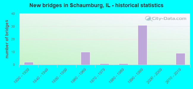
- New bridges - historical statistics
- 21930-1939
- 101960-1969
- 11970-1979
- 11980-1989
- 311990-1999
- 92010-2019

- Reconstructed bridges - Historical Statistics
- 21970-1979
- 21980-1989
- 31990-1999
- 22000-2009


- Bridge Condition - Deck
- 20.0%Very good
- 44.0%Good
- 28.0%Satisfactory
- 4.0%Fair
- 4.0%Critical

- Bridge Condition - Superstructure
- 36.0%Very good
- 40.0%Good
- 16.0%Satisfactory
- 4.0%Poor
- 4.0%Critical

- Bridge Condition - Substructure
- 8.0%Very good
- 72.0%Good
- 20.0%Satisfactory

- Bridge Condition - Channel
- 50.0%Very good
- 30.0%Good
- 10.0%Satisfactory
- 10.0%Poor

- Bridge Condition - Culverts
- 25.0%Very good
- 12.5%Good
- 50.0%Satisfactory
- 12.5%Fair
Find on map >> Show street view
Structure Number: 160978, Location: 0.5 M N IL 72 (Lat: 42.043183, Lng: -88.030633), Route carried "on" structure: Interstate 290, Year Built: 1969, Year Reconstructed: 2007, Status: Open, Structure Length: 5.13m (16.83ft), Average Daily Traffic: 57,400 (year 2021), Truck Traffic: 12%, Average Future Daily Traffic: 91,979 (year 2032), Design Load: HS 20+Mod, Features Intersected: WOODFIELD RD
Minimum Vertical Clearance: 30+ m (98+ ft), Kilometerpoint: 1.481, Lanes on structure: 4, Lanes under structure: 4, Base Highway Network: Yes, Owner: State Highway Agency, Approaching Roadway Width: 21.3m (69.9ft), Material/Design: Steel continuous, Design/Construction: Stringer/Multi-beam, Number Of Spans In Main Unit: 3, Length of Maximum Span: 23.9m (78.4ft), Curb-To-Curb Width: 21.2m (69.6ft), Out-to-Out Width: 22.3m (73.2ft)
Condition: Deck: Fair, Superstructure: Satisfactory, Substructure: Satisfactory, Operating Rating: 82.0 metric tons, Method Used To Determine Operating Rating: Load Factor (LF) rating reported by rating factor (RF) method using MS18 loading, Inventory Rating: 42.1 metric tons, Method Used To Determine Inventory Rating: Load Factor (LF) rating reported by rating factor (RF) method using MS18 loading, Structural Evaluation: Equal to present minimum criteria, Deck Geometry: Better than present minimum criteria, Underclear: Equal to present minimum criteria, Approach Roadway Alignment: Equal to present desirable criteria, Designated Inspection Frequency: Every 24 months, Inspection Date: March 2021, Deck Structure Type: Concrete Cast-file-Place, Wearing Surface/Protective System: Wearing Surface: Latex Concrete
Find on map >> Show street view
Structure Number: 160979, Location: 0.5 M N IL 72 (Lat: 42.043047, Lng: -88.030658), Route carried "on" structure: Interstate 290, Year Built: 1969, Year Reconstructed: 2003, Status: Open, Structure Length: 5.13m (16.83ft), Average Daily Traffic: 57,400 (year 2021), Truck Traffic: 12%, Average Future Daily Traffic: 91,979 (year 2032), Design Load: HS 20+Mod, Features Intersected: WOODFIELD RD
Minimum Vertical Clearance: 30+ m (98+ ft), Kilometerpoint: 1.497, Lanes on structure: 4, Lanes under structure: 4, Base Highway Network: Yes, Owner: State Highway Agency, Approaching Roadway Width: 24.6m (80.7ft), Material/Design: Steel continuous, Design/Construction: Stringer/Multi-beam, Number Of Spans In Main Unit: 3, Length of Maximum Span: 23.9m (78.4ft), Curb-To-Curb Width: 25.0m (82.0ft), Out-to-Out Width: 26.0m (85.3ft)
Condition: Deck: Satisfactory, Superstructure: Good, Substructure: Good, Operating Rating: 65.1 metric tons, Method Used To Determine Operating Rating: Load Factor (LF) rating reported by rating factor (RF) method using MS18 loading, Inventory Rating: 38.9 metric tons, Method Used To Determine Inventory Rating: Load Factor (LF) rating reported by rating factor (RF) method using MS18 loading, Structural Evaluation: Better than present minimum criteria, Deck Geometry: Superior to present desirable criteria, Underclear: Equal to present minimum criteria, Approach Roadway Alignment: Equal to present desirable criteria, Designated Inspection Frequency: Every 24 months, Inspection Date: March 2021, Deck Structure Type: Concrete Cast-file-Place, Wearing Surface/Protective System: Deck Protection: Epoxy Coated Reinforcing
Find on map >> Show street view
Structure Number: 16098, Location: 1 M N IL 72 (Lat: 42.050700, Lng: -88.029128), Route carried "on" structure: Interstate 290, Year Built: 1969, Year Reconstructed: 2007, Status: Open, Structure Length: 7.03m (23.06ft), Average Daily Traffic: 69,400 (year 2021), Truck Traffic: 6%, Average Future Daily Traffic: 216,197 (year 2032), Design Load: HS 20+Mod, Features Intersected: IL 58 (GOLF RD)
Minimum Vertical Clearance: 30+ m (98+ ft), Kilometerpoint: 0.740, Lanes on structure: 12, Lanes under structure: 9, Base Highway Network: Yes, Owner: State Highway Agency, Approaching Roadway Width: 31.1m (102.0ft), Skew: 30 degrees, Material/Design: Steel continuous, Design/Construction: Stringer/Multi-beam, Number Of Spans In Main Unit: 3, Length of Maximum Span: 39.3m (128.9ft), Curb-To-Curb Width: 66.4m (217.8ft), Out-to-Out Width: 71.3m (233.9ft)
Condition: Deck: Satisfactory, Superstructure: Poor, Substructure: Satisfactory, Operating Rating: 54.1 metric tons, Method Used To Determine Operating Rating: Load Factor (LF) rating reported by rating factor (RF) method using MS18 loading, Inventory Rating: 32.4 metric tons, Method Used To Determine Inventory Rating: Load Factor (LF) rating reported by rating factor (RF) method using MS18 loading, Structural Evaluation: Meets minimum limits, Deck Geometry: Superior to present desirable criteria, Underclear: Meets minimum limits, Approach Roadway Alignment: Equal to present desirable criteria, Designated Inspection Frequency: Every 12 months, Other Special Inspection Frequency: Every 24 months, Inspection Date: December 2021, Other Special Inspection Date: December 2021, Deck Structure Type: Concrete Cast-file-Place, Wearing Surface/Protective System: Wearing Surface: Latex Concrete
Find on map >> Show street view
Structure Number: 160981, Location: 1.2 M S IL 72 (Lat: 42.019819, Lng: -88.031258), Route carried "on" structure: Interstate 290, Year Built: 1970, Status: Open, Structure Length: 1.10m (3.61ft), Average Daily Traffic: 156,500 (year 2021), Truck Traffic: 9%, Average Future Daily Traffic: 212,077 (year 2032), Design Load: HS 20+Mod, Features Intersected: SALT CREEK
Minimum Vertical Clearance: 30+ m (98+ ft), Kilometerpoint: 4.072, Lanes on structure: 10, Base Highway Network: Yes, Owner: State Highway Agency, Approaching Roadway Width: 48.8m (160.1ft), Skew: 11 degrees, Material/Design: Concrete continuous, Design/Construction: Culvert, Number Of Spans In Main Unit: 3, Length of Maximum Span: 4.3m (14.1ft)
Condition: Channel: Very good, Culverts: Satisfactory, Operating Rating: 89.1 metric tons, Method Used To Determine Operating Rating: Load Factor (LF) rating reported by rating factor (RF) method using MS18 loading, Inventory Rating: 89.1 metric tons, Method Used To Determine Inventory Rating: Load Factor (LF) rating reported by rating factor (RF) method using MS18 loading, Structural Evaluation: Equal to present minimum criteria, Waterway Adequacy: Equal to present desirable criteria, Approach Roadway Alignment: Equal to present desirable criteria, Designated Inspection Frequency: Every 24 months, Inspection Date: April 2020, Deck Structure Type: Concrete Cast-file-Place
Find on map >> Show street view
Structure Number: 160982, Location: 1.0 M S IL 58 (Lat: 42.036828, Lng: -88.031061), Route carried "on" structure: Interstate 290, Year Built: 1969, Year Reconstructed: 2003, Status: Open, Structure Length: 7.25m (23.79ft), Average Daily Traffic: 54,400 (year 2021), Truck Traffic: 14%, Average Future Daily Traffic: 80,546 (year 2032), Design Load: HS 20+Mod, Features Intersected: IL 72 (HIGGINS RD)
Minimum Vertical Clearance: 30+ m (98+ ft), Kilometerpoint: 2.285, Lanes on structure: 4, Lanes under structure: 8, Base Highway Network: Yes, Owner: State Highway Agency, Approaching Roadway Width: 21.6m (70.9ft), Skew: 1 degrees, Material/Design: Steel continuous, Design/Construction: Stringer/Multi-beam, Number Of Spans In Main Unit: 3, Length of Maximum Span: 41.3m (135.5ft), Curb-To-Curb Width: 21.6m (70.9ft), Out-to-Out Width: 22.6m (74.1ft)
Condition: Deck: Good, Superstructure: Good, Substructure: Good, Operating Rating: 97.2 metric tons, Method Used To Determine Operating Rating: Load Factor (LF) rating reported by rating factor (RF) method using MS18 loading, Inventory Rating: 48.0 metric tons, Method Used To Determine Inventory Rating: Load Factor (LF) rating reported by rating factor (RF) method using MS18 loading, Structural Evaluation: Better than present minimum criteria, Deck Geometry: Better than present minimum criteria, Underclear: Somewhat better than minimum adequacy, Approach Roadway Alignment: Equal to present desirable criteria, Designated Inspection Frequency: Every 24 months, Inspection Date: January 2021, Deck Structure Type: Concrete Cast-file-Place, Wearing Surface/Protective System: Deck Protection: Epoxy Coated Reinforcing
Find on map >> Show street view
Structure Number: 160983, Location: 1.0 M N IL 58 (Lat: 42.036800, Lng: -88.031061), Route carried "on" structure: Interstate 290, Year Built: 1969, Year Reconstructed: 2003, Status: Open, Structure Length: 7.25m (23.79ft), Average Daily Traffic: 54,400 (year 2021), Truck Traffic: 14%, Average Future Daily Traffic: 80,546 (year 2032), Design Load: HS 20+Mod, Features Intersected: IL 72 (HIGGINS RD)
Minimum Vertical Clearance: 30+ m (98+ ft), Kilometerpoint: 2.301, Lanes on structure: 4, Lanes under structure: 8, Base Highway Network: Yes, Owner: State Highway Agency, Approaching Roadway Width: 21.6m (70.9ft), Skew: 1 degrees, Material/Design: Steel continuous, Design/Construction: Stringer/Multi-beam, Number Of Spans In Main Unit: 3, Length of Maximum Span: 41.3m (135.5ft), Curb-To-Curb Width: 21.6m (70.9ft), Out-to-Out Width: 22.6m (74.1ft)
Condition: Deck: Good, Superstructure: Good, Substructure: Good, Operating Rating: 76.8 metric tons, Method Used To Determine Operating Rating: Load Factor (LF) rating reported by rating factor (RF) method using MS18 loading, Inventory Rating: 46.0 metric tons, Method Used To Determine Inventory Rating: Load Factor (LF) rating reported by rating factor (RF) method using MS18 loading, Structural Evaluation: Better than present minimum criteria, Deck Geometry: Better than present minimum criteria, Underclear: Somewhat better than minimum adequacy, Approach Roadway Alignment: Equal to present desirable criteria, Designated Inspection Frequency: Every 24 months, Inspection Date: January 2021, Deck Structure Type: Concrete Cast-file-Place, Wearing Surface/Protective System: Deck Protection: Epoxy Coated Reinforcing
Find on map >> Show street view
Structure Number: 161227, Location: 0.4M E OF PLUM GROVE (Lat: 42.039906, Lng: -88.052914), Route carried "on" structure: State highway 72, Year Built: 1930, Year Reconstructed: 1970, Status: Open, Structure Length: 1.00m (3.28ft), Average Daily Traffic: 45,300 (year 2021), Truck Traffic: 4%, Average Future Daily Traffic: 22,454 (year 2032), Features Intersected: TRIB OF W BR SALT CR
Minimum Vertical Clearance: 30+ m (98+ ft), Kilometerpoint: 155.056, Lanes on structure: 5, Base Highway Network: Yes, Owner: State Highway Agency, Approaching Roadway Width: 29.9m (98.1ft), Skew: 10 degrees, Material/Design: Concrete continuous, Design/Construction: Culvert, Number Of Spans In Main Unit: 4, Length of Maximum Span: 2.4m (7.9ft), Curb or Sidewalk Widths: Left: 0.0m, Right: 2.4m (7.9ft)
Condition: Channel: Good, Culverts: Satisfactory, Operating Rating: 54.1 metric tons, Method Used To Determine Operating Rating: Field evaluation and documented engineering judgment, Inventory Rating: 32.4 metric tons, Method Used To Determine Inventory Rating: Field evaluation and documented engineering judgment, Structural Evaluation: Equal to present minimum criteria, Waterway Adequacy: Equal to present desirable criteria, Approach Roadway Alignment: Equal to present desirable criteria, Designated Inspection Frequency: Every 24 months, Inspection Date: July 2020
Find on map >> Show street view
Structure Number: 162557, Location: 0.6 M W ROSELLE RD (Lat: 41.997547, Lng: -88.091936), Route carried "on" structure: State highway 390, Year Built: 1992, Status: Open, Structure Length: 4.61m (15.12ft), Average Daily Traffic: 46,900 (year 2020), Truck Traffic: 8%, Average Future Daily Traffic: 19,467 (year 2032), Design Load: HS 20+Mod, Features Intersected: MITCHELL BLVD
Minimum Vertical Clearance: 30+ m (98+ ft), Kilometerpoint: 4.200, Lanes on structure: 2, Lanes under structure: 2, Base Highway Network: Yes, Toll: On toll road, Owner: State Toll Authority, Approaching Roadway Width: 11.6m (38.1ft), Material/Design: Steel, Design/Construction: Stringer/Multi-beam, Number Of Spans In Main Unit: 1, Number Of Approach Spans: 2, Length of Maximum Span: 31.2m (102.4ft), Curb-To-Curb Width: 12.2m (40.0ft), Out-to-Out Width: 13.2m (43.3ft)
Condition: Deck: Good, Superstructure: Very good, Substructure: Good, Operating Rating: 60.6 metric tons, Method Used To Determine Operating Rating: Load Factor (LF) rating reported by rating factor (RF) method using MS18 loading, Inventory Rating: 36.3 metric tons, Method Used To Determine Inventory Rating: Load Factor (LF) rating reported by rating factor (RF) method using MS18 loading, Structural Evaluation: Better than present minimum criteria, Deck Geometry: Better than present minimum criteria, Underclear: Meets minimum limits, Approach Roadway Alignment: Equal to present desirable criteria, Designated Inspection Frequency: Every 24 months, Inspection Date: September 2020, Deck Structure Type: Concrete Cast-file-Place, Wearing Surface/Protective System: Deck Protection: Epoxy Coated Reinforcing
Find on map >> Show street view
Structure Number: 162558, Location: 0.6 M W ROSELLE RD (Lat: 41.997547, Lng: -88.091936), Route carried "on" structure: State highway 390, Year Built: 1992, Status: Open, Structure Length: 4.61m (15.12ft), Average Daily Traffic: 46,900 (year 2020), Truck Traffic: 8%, Average Future Daily Traffic: 19,467 (year 2032), Design Load: HS 20+Mod, Features Intersected: MITCHELL BLVD
Minimum Vertical Clearance: 30+ m (98+ ft), Kilometerpoint: 4.200, Lanes on structure: 2, Lanes under structure: 2, Base Highway Network: Yes, Toll: On toll road, Owner: State Toll Authority, Approaching Roadway Width: 11.6m (38.1ft), Material/Design: Steel, Design/Construction: Stringer/Multi-beam, Number Of Spans In Main Unit: 1, Number Of Approach Spans: 2, Length of Maximum Span: 31.2m (102.4ft), Curb-To-Curb Width: 12.2m (40.0ft), Out-to-Out Width: 13.2m (43.3ft)
Condition: Deck: Very good, Superstructure: Very good, Substructure: Good, Operating Rating: 65.4 metric tons, Method Used To Determine Operating Rating: Load Factor (LF) rating reported by rating factor (RF) method using MS18 loading, Inventory Rating: 39.2 metric tons, Method Used To Determine Inventory Rating: Load Factor (LF) rating reported by rating factor (RF) method using MS18 loading, Structural Evaluation: Better than present minimum criteria, Deck Geometry: Better than present minimum criteria, Underclear: Superior to present desirable criteria, Approach Roadway Alignment: Equal to present desirable criteria, Designated Inspection Frequency: Every 24 months, Inspection Date: September 2020, Deck Structure Type: Concrete Cast-file-Place, Wearing Surface/Protective System: Deck Protection: Epoxy Coated Reinforcing
Find on map >> Show street view
Structure Number: 162559, Location: 0.5 M W ROSELLE RD (Lat: 41.997447, Lng: -88.090328), Route carried "on" structure: State highway 390, Year Built: 1992, Year Reconstructed: 1994, Status: Open, Structure Length: 4.33m (14.21ft), Average Daily Traffic: 48,200 (year 2020), Truck Traffic: 9%, Average Future Daily Traffic: 19,467 (year 2032), Design Load: HS 20, Features Intersected: RR - CP SPUR
Minimum Vertical Clearance: 30+ m (98+ ft), Kilometerpoint: 4.345, Lanes on structure: 2, Base Highway Network: Yes, Toll: On toll road, Owner: State Toll Authority, Approaching Roadway Width: 12.2m (40.0ft), Material/Design: Prestressed concrete continuous, Design/Construction: Stringer/Multi-beam, Number Of Spans In Main Unit: 3, Length of Maximum Span: 14.4m (47.2ft), Curb-To-Curb Width: 12.2m (40.0ft), Out-to-Out Width: 13.2m (43.3ft)
Condition: Deck: Very good, Superstructure: Satisfactory, Substructure: Good, Operating Rating: 75.8 metric tons, Method Used To Determine Operating Rating: Load Factor (LF) rating reported by rating factor (RF) method using MS18 loading, Inventory Rating: 45.4 metric tons, Method Used To Determine Inventory Rating: Load Factor (LF) rating reported by rating factor (RF) method using MS18 loading, Structural Evaluation: Equal to present minimum criteria, Deck Geometry: Better than present minimum criteria, Underclear: High priority of corrective action, Approach Roadway Alignment: Equal to present desirable criteria, Designated Inspection Frequency: Every 24 months, Inspection Date: August 2020, Deck Structure Type: Concrete Cast-file-Place, Wearing Surface/Protective System: Deck Protection: Epoxy Coated Reinforcing
Find on map >> Show street view
Structure Number: 16256, Location: 0.5 M W ROSELLE RD (Lat: 41.997447, Lng: -88.090328), Route carried "on" structure: State highway 390, Year Built: 1992, Year Reconstructed: 1994, Status: Open, Structure Length: 4.42m (14.50ft), Average Daily Traffic: 48,200 (year 2020), Truck Traffic: 9%, Average Future Daily Traffic: 19,467 (year 2032), Design Load: HS 20, Features Intersected: RR - SPUR
Minimum Vertical Clearance: 30+ m (98+ ft), Kilometerpoint: 4.345, Lanes on structure: 2, Base Highway Network: Yes, Toll: On toll road, Owner: State Toll Authority, Approaching Roadway Width: 12.2m (40.0ft), Material/Design: Prestressed concrete continuous, Design/Construction: Stringer/Multi-beam, Number Of Spans In Main Unit: 3, Length of Maximum Span: 14.4m (47.2ft), Curb-To-Curb Width: 12.2m (40.0ft), Out-to-Out Width: 13.2m (43.3ft)
Condition: Deck: Very good, Superstructure: Satisfactory, Substructure: Good, Operating Rating: 74.2 metric tons, Method Used To Determine Operating Rating: Load Factor (LF) rating reported by rating factor (RF) method using MS18 loading, Inventory Rating: 44.4 metric tons, Method Used To Determine Inventory Rating: Load Factor (LF) rating reported by rating factor (RF) method using MS18 loading, Structural Evaluation: Equal to present minimum criteria, Deck Geometry: Better than present minimum criteria, Underclear: High priority of corrective action, Approach Roadway Alignment: Equal to present desirable criteria, Designated Inspection Frequency: Every 24 months, Inspection Date: August 2020, Deck Structure Type: Concrete Cast-file-Place, Wearing Surface/Protective System: Deck Protection: Epoxy Coated Reinforcing
Find on map >> Show street view
Structure Number: 162568, Location: 1.1 M W ROSELLE RD (Lat: 41.997142, Lng: -88.102161), Route carried "on" structure: State highway 390, Year Built: 1992, Status: Open, Structure Length: 5.04m (16.54ft), Average Daily Traffic: 46,900 (year 2020), Truck Traffic: 8%, Average Future Daily Traffic: 17,459 (year 2032), Features Intersected: WRIGHT BLVD
Minimum Vertical Clearance: 30+ m (98+ ft), Kilometerpoint: 3.444, Lanes on structure: 2, Lanes under structure: 4, Base Highway Network: Yes, Toll: On toll road, Owner: State Toll Authority, Approaching Roadway Width: 12.2m (40.0ft), Material/Design: Steel, Design/Construction: Stringer/Multi-beam, Number Of Spans In Main Unit: 1, Number Of Approach Spans: 2, Length of Maximum Span: 35.4m (116.1ft), Curb-To-Curb Width: 12.2m (40.0ft), Out-to-Out Width: 13.2m (43.3ft)
Condition: Deck: Good, Superstructure: Good, Substructure: Satisfactory, Operating Rating: 74.5 metric tons, Method Used To Determine Operating Rating: Load Factor (LF) rating reported by rating factor (RF) method using MS18 loading, Inventory Rating: 44.7 metric tons, Method Used To Determine Inventory Rating: Load Factor (LF) rating reported by rating factor (RF) method using MS18 loading, Structural Evaluation: Equal to present minimum criteria, Deck Geometry: Better than present minimum criteria, Underclear: Meets minimum limits, Approach Roadway Alignment: Equal to present desirable criteria, Designated Inspection Frequency: Every 24 months, Inspection Date: September 2020, Deck Structure Type: Concrete Cast-file-Place, Wearing Surface/Protective System: Deck Protection: Epoxy Coated Reinforcing
Find on map >> Show street view
Structure Number: 162569, Location: 1.1 M W ROSELLE RD (Lat: 41.997169, Lng: -88.101508), Route carried "on" structure: State highway 390, Year Built: 1992, Status: Open, Structure Length: 5.00m (16.40ft), Average Daily Traffic: 46,900 (year 2020), Truck Traffic: 8%, Average Future Daily Traffic: 17,459 (year 2032), Features Intersected: WRIGHT BLVD
Minimum Vertical Clearance: 30+ m (98+ ft), Kilometerpoint: 3.492, Lanes on structure: 2, Lanes under structure: 4, Base Highway Network: Yes, Toll: On toll road, Owner: State Toll Authority, Approaching Roadway Width: 12.2m (40.0ft), Material/Design: Steel, Design/Construction: Stringer/Multi-beam, Number Of Spans In Main Unit: 1, Number Of Approach Spans: 2, Length of Maximum Span: 35.4m (116.1ft), Curb-To-Curb Width: 12.2m (40.0ft), Out-to-Out Width: 13.5m (44.3ft)
Condition: Deck: Good, Superstructure: Very good, Substructure: Good, Operating Rating: 74.5 metric tons, Method Used To Determine Operating Rating: Load Factor (LF) rating reported by rating factor (RF) method using MS18 loading, Inventory Rating: 44.7 metric tons, Method Used To Determine Inventory Rating: Load Factor (LF) rating reported by rating factor (RF) method using MS18 loading, Structural Evaluation: Better than present minimum criteria, Deck Geometry: Better than present minimum criteria, Underclear: Superior to present desirable criteria, Approach Roadway Alignment: Equal to present desirable criteria, Designated Inspection Frequency: Every 24 months, Inspection Date: September 2020, Deck Structure Type: Concrete Cast-file-Place, Wearing Surface/Protective System: Deck Protection: Epoxy Coated Reinforcing
Find on map >> Show street view
Structure Number: 16257, Location: 1.5 M W ROSELLE RD (Lat: 41.996803, Lng: -88.109981), Route carried "on" structure: State highway 390, Year Built: 1992, Status: Open, Structure Length: 5.44m (17.85ft), Average Daily Traffic: 43,300 (year 2020), Truck Traffic: 9%, Average Future Daily Traffic: 17,458 (year 2032), Features Intersected: RODENBERG RD
Minimum Vertical Clearance: 30+ m (98+ ft), Kilometerpoint: 2.848, Lanes on structure: 2, Lanes under structure: 4, Base Highway Network: Yes, Toll: On toll road, Owner: State Toll Authority, Approaching Roadway Width: 12.2m (40.0ft), Material/Design: Steel, Design/Construction: Stringer/Multi-beam, Number Of Spans In Main Unit: 1, Number Of Approach Spans: 2, Length of Maximum Span: 39.6m (129.9ft), Curb-To-Curb Width: 16.4m (53.8ft), Out-to-Out Width: 17.4m (57.1ft)
Condition: Deck: Very good, Superstructure: Good, Substructure: Satisfactory, Operating Rating: 61.9 metric tons, Method Used To Determine Operating Rating: Load Factor (LF) rating reported by rating factor (RF) method using MS18 loading, Inventory Rating: 37.3 metric tons, Method Used To Determine Inventory Rating: Load Factor (LF) rating reported by rating factor (RF) method using MS18 loading, Structural Evaluation: Equal to present minimum criteria, Deck Geometry: Superior to present desirable criteria, Underclear: Somewhat better than minimum adequacy, Approach Roadway Alignment: Equal to present desirable criteria, Designated Inspection Frequency: Every 24 months, Inspection Date: September 2020, Deck Structure Type: Concrete Cast-file-Place, Wearing Surface/Protective System: Deck Protection: Epoxy Coated Reinforcing
Find on map >> Show street view
Structure Number: 162571, Location: 1.5 M W ROSELLE RD (Lat: 41.996842, Lng: -88.109042), Route carried "on" structure: State highway 390, Year Built: 1992, Status: Open, Structure Length: 5.39m (17.68ft), Average Daily Traffic: 43,600 (year 2020), Truck Traffic: 9%, Average Future Daily Traffic: 25,853 (year 2032), Features Intersected: RODENBERG RD
Minimum Vertical Clearance: 30+ m (98+ ft), Kilometerpoint: 2.929, Lanes on structure: 2, Lanes under structure: 4, Base Highway Network: Yes, Toll: On toll road, Owner: State Toll Authority, Approaching Roadway Width: 7.6m (24.9ft), Material/Design: Steel, Design/Construction: Stringer/Multi-beam, Number Of Spans In Main Unit: 1, Number Of Approach Spans: 2, Length of Maximum Span: 39.0m (128.0ft), Curb or Sidewalk Widths: Left: 1.5m (4.9ft), Right: 0.0m, Curb-To-Curb Width: 12.2m (40.0ft), Out-to-Out Width: 13.5m (44.3ft)
Condition: Deck: Good, Superstructure: Good, Substructure: Good, Operating Rating: 87.5 metric tons, Method Used To Determine Operating Rating: Load Factor (LF) rating reported by rating factor (RF) method using MS18 loading, Inventory Rating: 52.5 metric tons, Method Used To Determine Inventory Rating: Load Factor (LF) rating reported by rating factor (RF) method using MS18 loading, Structural Evaluation: Better than present minimum criteria, Deck Geometry: Better than present minimum criteria, Underclear: Meets minimum limits, Approach Roadway Alignment: Equal to present desirable criteria, Length Of Structure Improvement: 6.46m (21.19ft), Designated Inspection Frequency: Every 24 months, Inspection Date: September 2020, Bridge Improvement Cost: $1,208,000, Roadway Improvement Cost: $121,000, Total Project Cost: $1,812,000, Deck Structure Type: Concrete Cast-file-Place, Wearing Surface/Protective System: Deck Protection: Epoxy Coated Reinforcing
Find on map >> Show street view
Structure Number: 162576, Location: RAMP WB EOH TO SB (Lat: 41.994469, Lng: -88.122208), Route carried "on" structure: Other road , Year Built: 1994, Status: Open, Structure Length: 3.80m (12.47ft), Average Daily Traffic: 1,000 (year 2020), Truck Traffic: 19%, Average Future Daily Traffic: 2,472 (year 2032), Design Load: HS 20, Features Intersected: SPRINGINGSGUTH RD, Facility Carried by Structure: IL 390 WB TO SB GA
Minimum Vertical Clearance: 30+ m (98+ ft), Kilometerpoint: 0.402, Lanes on structure: 1, Lanes under structure: 5, Base Highway Network: Yes (Inventory Route: 20345040, Subroute: 70), Toll: On toll road, Owner: State Toll Authority, Approaching Roadway Width: 7.9m (25.9ft), Skew: 3 degrees, Material/Design: Steel, Design/Construction: Stringer/Multi-beam, Number Of Spans In Main Unit: 1, Length of Maximum Span: 36.3m (119.1ft), Curb-To-Curb Width: 7.9m (25.9ft), Out-to-Out Width: 8.9m (29.2ft)
Condition: Deck: Good, Superstructure: Good, Substructure: Good, Operating Rating: 86.8 metric tons, Method Used To Determine Operating Rating: Load Factor (LF) rating reported by rating factor (RF) method using MS18 loading, Inventory Rating: 52.2 metric tons, Method Used To Determine Inventory Rating: Load Factor (LF) rating reported by rating factor (RF) method using MS18 loading, Structural Evaluation: Better than present minimum criteria, Deck Geometry: Somewhat better than minimum adequacy, Underclear: High priority of corrective action, Approach Roadway Alignment: Equal to present desirable criteria, Designated Inspection Frequency: Every 24 months, Inspection Date: April 2021, Deck Structure Type: Concrete Cast-file-Place, Wearing Surface/Protective System: Deck Protection: Epoxy Coated Reinforcing
Find on map >> Show street view
Structure Number: 162587, Location: EAST OF WISE RD (Lat: 41.995161, Lng: -88.118769), Route carried "on" structure: State highway 390, Year Built: 1992, Status: Open, Structure Length: 4.21m (13.81ft), Average Daily Traffic: 32,600 (year 2020), Truck Traffic: 6%, Average Future Daily Traffic: 17,613 (year 2032), Design Load: HS 20, Features Intersected: SPRINGINGSGUTH RD
Minimum Vertical Clearance: 30+ m (98+ ft), Kilometerpoint: 2.189, Lanes on structure: 2, Lanes under structure: 4, Base Highway Network: Yes, Toll: On toll road, Owner: State Toll Authority, Approaching Roadway Width: 15.5m (50.9ft), Skew: 3 degrees, Material/Design: Steel, Design/Construction: Stringer/Multi-beam, Number Of Spans In Main Unit: 1, Length of Maximum Span: 40.1m (131.6ft), Curb-To-Curb Width: 15.5m (50.9ft), Out-to-Out Width: 16.5m (54.1ft)
Condition: Deck: Satisfactory, Superstructure: Good, Substructure: Good, Operating Rating: 94.9 metric tons, Method Used To Determine Operating Rating: Load Factor (LF) rating reported by rating factor (RF) method using MS18 loading, Inventory Rating: 57.0 metric tons, Method Used To Determine Inventory Rating: Load Factor (LF) rating reported by rating factor (RF) method using MS18 loading, Structural Evaluation: Better than present minimum criteria, Deck Geometry: Superior to present desirable criteria, Underclear: Somewhat better than minimum adequacy, Approach Roadway Alignment: Equal to present desirable criteria, Designated Inspection Frequency: Every 24 months, Inspection Date: April 2021, Deck Structure Type: Concrete Cast-file-Place, Wearing Surface/Protective System: Deck Protection: Epoxy Coated Reinforcing
Find on map >> Show street view
Structure Number: 162588, Location: EAST OF WISE RD (Lat: 41.995236, Lng: -88.118614), Route carried "on" structure: State highway 390, Year Built: 1992, Status: Open, Structure Length: 4.21m (13.81ft), Average Daily Traffic: 32,600 (year 2020), Truck Traffic: 6%, Average Future Daily Traffic: 17,613 (year 2032), Design Load: HS 20, Features Intersected: SPRINGINGSGUTH RD
Minimum Vertical Clearance: 30+ m (98+ ft), Kilometerpoint: 2.205, Lanes on structure: 2, Lanes under structure: 4, Base Highway Network: Yes, Toll: On toll road, Owner: State Toll Authority, Approaching Roadway Width: 12.2m (40.0ft), Skew: 3 degrees, Material/Design: Steel, Design/Construction: Stringer/Multi-beam, Number Of Spans In Main Unit: 1, Length of Maximum Span: 40.1m (131.6ft), Curb-To-Curb Width: 12.2m (40.0ft), Out-to-Out Width: 13.2m (43.3ft)
Condition: Deck: Good, Superstructure: Satisfactory, Substructure: Good, Operating Rating: 89.4 metric tons, Method Used To Determine Operating Rating: Load Factor (LF) rating reported by rating factor (RF) method using MS18 loading, Inventory Rating: 53.8 metric tons, Method Used To Determine Inventory Rating: Load Factor (LF) rating reported by rating factor (RF) method using MS18 loading, Structural Evaluation: Equal to present minimum criteria, Deck Geometry: Better than present minimum criteria, Underclear: Superior to present desirable criteria, Approach Roadway Alignment: Equal to present desirable criteria, Designated Inspection Frequency: Every 24 months, Inspection Date: April 2021, Deck Structure Type: Concrete Cast-file-Place, Wearing Surface/Protective System: Deck Protection: Epoxy Coated Reinforcing
Find on map >> Show street view
Structure Number: 162589, Location: EAST OF WISE RD (Lat: 41.994372, Lng: -88.121536), Route carried "on" structure: Other road , Year Built: 1992, Status: Open, Structure Length: 15.30m (50.20ft), Average Daily Traffic: 4,200 (year 2020), Truck Traffic: 23%, Average Future Daily Traffic: 8,446 (year 2032), Design Load: HS 20, Features Intersected: IL 390 EOH & RAMP, Facility Carried by Structure: IL 390 WB TO SB GA
Minimum Vertical Clearance: 30+ m (98+ ft), Kilometerpoint: 0.435, Lanes on structure: 1, Lanes under structure: 1, Base Highway Network: Yes (Inventory Route: 20345040, Subroute: 10), Toll: On toll road, Owner: State Toll Authority, Approaching Roadway Width: 7.9m (25.9ft), Material/Design: Steel continuous, Design/Construction: Stringer/Multi-beam, Number Of Spans In Main Unit: 3, Length of Maximum Span: 63.5m (208.3ft), Curb-To-Curb Width: 7.9m (25.9ft), Out-to-Out Width: 8.9m (29.2ft)
Condition: Deck: Satisfactory, Superstructure: Very good, Substructure: Good, Operating Rating: 50.5 metric tons, Method Used To Determine Operating Rating: Load Factor (LF) rating reported by rating factor (RF) method using MS18 loading, Inventory Rating: 30.1 metric tons, Method Used To Determine Inventory Rating: Load Factor (LF) rating reported by rating factor (RF) method using MS18 loading, Structural Evaluation: Better than present minimum criteria, Deck Geometry: High priority of corrective action, Underclear: Superior to present desirable criteria, Approach Roadway Alignment: Equal to present minimum criteria, Designated Inspection Frequency: Every 24 months, Inspection Date: April 2021, Deck Structure Type: Concrete Cast-file-Place, Wearing Surface/Protective System: Deck Protection: Epoxy Coated Reinforcing
Find on map >> Show street view
Structure Number: 16259, Location: EAST OF WISE RD (Lat: 41.992178, Lng: -88.121861), Route carried "on" structure: Other road , Year Built: 1992, Status: Open, Structure Length: 11.95m (39.21ft), Average Daily Traffic: 4,000 (year 2020), Truck Traffic: 23%, Average Future Daily Traffic: 7,725 (year 2032), Design Load: HS 20, Features Intersected: IL 390 EB 2 SPRNGGTH, Facility Carried by Structure: GARY NB TO IL 390
Minimum Vertical Clearance: 30+ m (98+ ft), Kilometerpoint: 0.225, Lanes on structure: 1, Lanes under structure: 1, Base Highway Network: Yes (Inventory Route: 20345040, Subroute: 50), Toll: On toll road, Owner: State Toll Authority, Approaching Roadway Width: 7.9m (25.9ft), Material/Design: Steel continuous, Design/Construction: Stringer/Multi-beam, Number Of Spans In Main Unit: 3, Length of Maximum Span: 57.0m (187.0ft), Curb-To-Curb Width: 7.9m (25.9ft), Out-to-Out Width: 8.9m (29.2ft)
Condition: Deck: Satisfactory, Superstructure: Very good, Substructure: Good, Operating Rating: 86.5 metric tons, Method Used To Determine Operating Rating: Load Factor (LF) rating reported by rating factor (RF) method using MS18 loading, Inventory Rating: 52.2 metric tons, Method Used To Determine Inventory Rating: Load Factor (LF) rating reported by rating factor (RF) method using MS18 loading, Structural Evaluation: Better than present minimum criteria, Deck Geometry: High priority of corrective action, Underclear: Superior to present desirable criteria, Approach Roadway Alignment: Equal to present desirable criteria, Length Of Structure Improvement: 12.41m (40.72ft), Designated Inspection Frequency: Every 24 months, Inspection Date: April 2021, Bridge Improvement Cost: $1,745,000, Roadway Improvement Cost: $175,000, Total Project Cost: $2,618,000, Deck Structure Type: Concrete Cast-file-Place, Wearing Surface/Protective System: Deck Protection: Epoxy Coated Reinforcing
Find on map >> Show street view
Structure Number: 162591, Location: SOUTH OF WISE RD (Lat: 41.996183, Lng: -88.116100), Route carried "on" structure: State highway 390, Year Built: 1992, Status: Open, Structure Length: 6.46m (21.19ft), Average Daily Traffic: 32,600 (year 2020), Truck Traffic: 6%, Average Future Daily Traffic: 17,613 (year 2032), Design Load: HS 20, Features Intersected: IL 19 (IRVING PK)
Minimum Vertical Clearance: 30+ m (98+ ft), Kilometerpoint: 2.446, Lanes on structure: 2, Lanes under structure: 6, Base Highway Network: Yes, Toll: On toll road, Owner: State Toll Authority, Approaching Roadway Width: 12.2m (40.0ft), Skew: 4 degrees, Material/Design: Steel continuous, Design/Construction: Stringer/Multi-beam, Number Of Spans In Main Unit: 2, Length of Maximum Span: 31.1m (102.0ft), Curb-To-Curb Width: 12.2m (40.0ft), Out-to-Out Width: 13.2m (43.3ft)
Condition: Deck: Satisfactory, Superstructure: Good, Substructure: Good, Operating Rating: 70.6 metric tons, Method Used To Determine Operating Rating: Load Factor (LF) rating reported by rating factor (RF) method using MS18 loading, Inventory Rating: 42.4 metric tons, Method Used To Determine Inventory Rating: Load Factor (LF) rating reported by rating factor (RF) method using MS18 loading, Structural Evaluation: Better than present minimum criteria, Deck Geometry: Better than present minimum criteria, Underclear: High priority of replacement, Approach Roadway Alignment: Equal to present desirable criteria, Length Of Structure Improvement: 7.74m (25.39ft), Designated Inspection Frequency: Every 24 months, Inspection Date: April 2021, Bridge Improvement Cost: $1,371,000, Roadway Improvement Cost: $137,000, Total Project Cost: $2,057,000, Deck Structure Type: Concrete Cast-file-Place, Wearing Surface/Protective System: Wearing Surface: Other, Deck Protection: Epoxy Coated Reinforcing
Find on map >> Show street view
Structure Number: 162592, Location: SOUTH OF WISE RD (Lat: 41.996172, Lng: -88.116144), Route carried "on" structure: State highway 390, Year Built: 1992, Status: Open, Structure Length: 6.46m (21.19ft), Average Daily Traffic: 32,600 (year 2020), Truck Traffic: 6%, Average Future Daily Traffic: 17,613 (year 2032), Design Load: HS 20, Features Intersected: IL 19 (IRVING PK)
Minimum Vertical Clearance: 30+ m (98+ ft), Kilometerpoint: 2.430, Lanes on structure: 2, Lanes under structure: 6, Base Highway Network: Yes, Toll: On toll road, Owner: State Toll Authority, Approaching Roadway Width: 12.2m (40.0ft), Skew: 4 degrees, Material/Design: Steel continuous, Design/Construction: Stringer/Multi-beam, Number Of Spans In Main Unit: 2, Length of Maximum Span: 31.1m (102.0ft), Curb-To-Curb Width: 12.2m (40.0ft), Out-to-Out Width: 13.2m (43.3ft)
Condition: Deck: Satisfactory, Superstructure: Good, Substructure: Good, Operating Rating: 90.4 metric tons, Method Used To Determine Operating Rating: Load Factor (LF) rating reported by rating factor (RF) method using MS18 loading, Inventory Rating: 54.1 metric tons, Method Used To Determine Inventory Rating: Load Factor (LF) rating reported by rating factor (RF) method using MS18 loading, Structural Evaluation: Better than present minimum criteria, Deck Geometry: Better than present minimum criteria, Underclear: High priority of replacement, Approach Roadway Alignment: Equal to present desirable criteria, Length Of Structure Improvement: 7.53m (24.70ft), Designated Inspection Frequency: Every 24 months, Inspection Date: April 2021, Bridge Improvement Cost: $1,332,000, Roadway Improvement Cost: $133,000, Total Project Cost: $1,998,000, Deck Structure Type: Concrete Cast-file-Place, Wearing Surface/Protective System: Deck Protection: Epoxy Coated Reinforcing
Find on map >> Show street view
Structure Number: 162656, Location: 0.3 M N IL 62 (Lat: 42.073819, Lng: -88.043892), Route carried "on" structure: Other road , Year Built: 1997, Status: Open, Structure Length: 2.50m (8.20ft), Average Daily Traffic: 15,600 (year 2018), Truck Traffic: 4%, Average Future Daily Traffic: 18,746 (year 2032), Features Intersected: SALT CREEK, Facility Carried by Structure: MEACHAM-PLUM GROVE
Minimum Vertical Clearance: 30+ m (98+ ft), Kilometerpoint: 5.262, Lanes on structure: 2, Base Highway Network: Yes, Owner: State Highway Agency, Approaching Roadway Width: 12.2m (40.0ft), Material/Design: Prestressed concrete, Design/Construction: Stringer/Multi-beam, Number Of Spans In Main Unit: 1, Length of Maximum Span: 24.2m (79.4ft), Curb or Sidewalk Widths: Left: 1.5m (4.9ft), Right: 1.5m (4.9ft), Curb-To-Curb Width: 13.4m (44.0ft), Out-to-Out Width: 14.2m (46.6ft)
Condition: Deck: Good, Superstructure: Very good, Substructure: Very good, Channel: Very good, Operating Rating: 74.2 metric tons, Method Used To Determine Operating Rating: Load Factor (LF) rating reported by rating factor (RF) method using MS18 loading, Inventory Rating: 41.8 metric tons, Method Used To Determine Inventory Rating: Load Factor (LF) rating reported by rating factor (RF) method using MS18 loading, Structural Evaluation: Equal to present desirable criteria, Deck Geometry: Equal to present minimum criteria, Waterway Adequacy: Better than present minimum criteria, Approach Roadway Alignment: Equal to present minimum criteria, Designated Inspection Frequency: Every 48 months, Inspection Date: September 2018, Deck Structure Type: Concrete Cast-file-Place, Wearing Surface/Protective System: Deck Protection: Epoxy Coated Reinforcing
Find on map >> Show street view
Structure Number: 163217, Location: 0.5 MI S. SCHAUMBURG (Lat: 42.018525, Lng: -88.045706), Route carried "on" structure: Other road , Year Built: 1985, Status: Open, Structure Length: 1.29m (4.23ft), Average Daily Traffic: 20,100 (year 2018), Truck Traffic: 5%, Average Future Daily Traffic: 24,617 (year 2032), Design Load: HS 20, Features Intersected: Salt Creek, Facility Carried by Structure: FAU-2585 Meacham R
Minimum Vertical Clearance: 30+ m (98+ ft), Kilometerpoint: 11.506, Lanes on structure: 4, Base Highway Network: Yes, Owner: County Highway Agency, Approaching Roadway Width: 20.7m (67.9ft), Skew: 22 degrees, Material/Design: Prestressed concrete, Design/Construction: Box Beam or Girders - Multiple, Number Of Spans In Main Unit: 1, Length of Maximum Span: 11.8m (38.7ft), Curb or Sidewalk Widths: Left: 1.5m (4.9ft), Right: 1.5m (4.9ft), Curb-To-Curb Width: 16.5m (54.1ft), Out-to-Out Width: 24.4m (80.1ft)
Condition: Deck: Critical, Superstructure: Critical, Substructure: Satisfactory, Channel: Satisfactory, Operating Rating: 58.6 metric tons, Method Used To Determine Operating Rating: Load Factor (LF) rating reported by rating factor (RF) method using MS18 loading, Inventory Rating: 35.0 metric tons, Method Used To Determine Inventory Rating: Load Factor (LF) rating reported by rating factor (RF) method using MS18 loading, Structural Evaluation: High priority of replacement, Deck Geometry: Meets minimum limits, Waterway Adequacy: Better than present minimum criteria, Approach Roadway Alignment: Equal to present desirable criteria, Designated Inspection Frequency: Every 24 months, Other Special Inspection Frequency: Every 6 months, Inspection Date: September 2021, Other Special Inspection Date: September 2021, Deck Structure Type: Concrete Precast Panels, Wearing Surface/Protective System: Wearing Surface: Latex Concrete
Find on map >> Show street view
Structure Number: 165002, Location: 0.5 M W MEACHAM P22 (Lat: 42.028272, Lng: -88.055964), Route carried "on" structure: Other road , Year Built: 1936, Year Reconstructed: 1978, Status: Open, Structure Length: 0.91m (2.99ft), Average Daily Traffic: 26,000 (year 2018), Truck Traffic: 2%, Average Future Daily Traffic: 26,780 (year 2032), Design Load: HS 20, Features Intersected: SALT CR, Facility Carried by Structure: SCHAUMBURG RD
Minimum Vertical Clearance: 30+ m (98+ ft), Kilometerpoint: 14.339, Lanes on structure: 4, Base Highway Network: Yes, Owner: County Highway Agency, Approaching Roadway Width: 20.1m (65.9ft), Skew: 21 degrees, Material/Design: Concrete, Design/Construction: Culvert, Number Of Spans In Main Unit: 3, Length of Maximum Span: 3.0m (9.8ft), Curb or Sidewalk Widths: Left: 1.2m (3.9ft), Right: 0.0m, Out-to-Out Width: 25.9m (85.0ft)
Condition: Channel: Poor, Culverts: Satisfactory, Operating Rating: 58.3 metric tons, Method Used To Determine Operating Rating: Load Factor (LF) rating reported by rating factor (RF) method using MS18 loading, Inventory Rating: 34.7 metric tons, Method Used To Determine Inventory Rating: Load Factor (LF) rating reported by rating factor (RF) method using MS18 loading, Structural Evaluation: Equal to present minimum criteria, Waterway Adequacy: Equal to present desirable criteria, Approach Roadway Alignment: Equal to present desirable criteria, Designated Inspection Frequency: Every 24 months, Inspection Date: June 2020
Find on map >> Show street view
Structure Number: 166206, Location: .1 M W Plum Grove Rd (Lat: 42.060867, Lng: -88.061794), Route carried "on" structure: City street , Year Built: 1997, Status: Open, Structure Length: 0.88m (2.89ft), Average Daily Traffic: 2,050 (year 2018), Truck Traffic: 18%, Average Future Daily Traffic: 2,500 (year 2032), Design Load: HS 20, Features Intersected: W Br. of Salt Creek, Facility Carried by Structure: Commerce Drive
Minimum Vertical Clearance: 30+ m (98+ ft), Kilometerpoint: 1.641, Lanes on structure: 2, Owner: City or Municipal Highway Agency, Approaching Roadway Width: 11.8m (38.7ft), Material/Design: Concrete, Design/Construction: Culvert, Number Of Spans In Main Unit: 1, Length of Maximum Span: 8.8m (28.9ft), Curb or Sidewalk Widths: Left: 0.0m, Right: 2.7m (8.9ft), Curb-To-Curb Width: 11.8m (38.7ft), Out-to-Out Width: 14.6m (47.9ft)
Condition: Channel: Very good, Culverts: Satisfactory, Operating Rating: 54.1 metric tons, Method Used To Determine Operating Rating: Field evaluation and documented engineering judgment, Inventory Rating: 32.4 metric tons, Method Used To Determine Inventory Rating: Field evaluation and documented engineering judgment, Structural Evaluation: Equal to present minimum criteria, Deck Geometry: Somewhat better than minimum adequacy, Waterway Adequacy: Superior to present desirable criteria, Approach Roadway Alignment: Equal to present desirable criteria, Designated Inspection Frequency: Every 24 months, Inspection Date: June 2021, Deck Structure Type: Concrete Cast-file-Place, Wearing Surface/Protective System: Deck Protection: Epoxy Coated Reinforcing
Find on map >> Show street view
Structure Number: 166207, Location: .14 M W National Pr. (Lat: 42.035833, Lng: -88.053156), Route carried "on" structure: City street , Year Built: 1992, Status: Open, Structure Length: 0.91m (2.99ft), Average Daily Traffic: 1,900 (year 2018), Truck Traffic: 4%, Average Future Daily Traffic: 1,000 (year 2032), Features Intersected: Trib W Br of Salt Cr, Facility Carried by Structure: Thacker Street
Minimum Vertical Clearance: 30+ m (98+ ft), Kilometerpoint: 0.579, Lanes on structure: 2, Owner: City or Municipal Highway Agency, Approaching Roadway Width: 9.1m (29.9ft), Material/Design: Concrete continuous, Design/Construction: Culvert, Number Of Spans In Main Unit: 3, Length of Maximum Span: 3.0m (9.8ft), Curb or Sidewalk Widths: Left: 1.5m (4.9ft), Right: 2.7m (8.9ft)
Condition: Channel: Good, Culverts: Fair, Operating Rating: 41.8 metric tons, Method Used To Determine Operating Rating: Load Factor (LF) rating reported by rating factor (RF) method using MS18 loading, Inventory Rating: 24.9 metric tons, Method Used To Determine Inventory Rating: Load Factor (LF) rating reported by rating factor (RF) method using MS18 loading, Structural Evaluation: Somewhat better than minimum adequacy, Waterway Adequacy: Equal to present desirable criteria, Approach Roadway Alignment: Equal to present desirable criteria, Designated Inspection Frequency: Every 24 months, Inspection Date: June 2021
Find on map >> Show street view
Structure Number: 166596, Location: 0.1Mi E of Braintree (Lat: 42.015742, Lng: -88.109422), Route carried "on" structure: City street , Year Built: 2014, Status: Open, Structure Length: 0.72m (2.36ft), Average Daily Traffic: 425 (year 2018), Truck Traffic: 6%, Average Future Daily Traffic: 421 (year 2032), Design Load: HS 25 or greater, Features Intersected: W. Br. DuPage River, Facility Carried by Structure: Cambridge Drive
Minimum Vertical Clearance: 30+ m (98+ ft), Kilometerpoint: 0.129, Lanes on structure: 2, Owner: City or Municipal Highway Agency, Approaching Roadway Width: 8.2m (26.9ft), Material/Design: Concrete, Design/Construction: Culvert, Number Of Spans In Main Unit: 2, Length of Maximum Span: 3.3m (10.8ft), Curb or Sidewalk Widths: Left: 1.5m (4.9ft), Right: 1.5m (4.9ft)
Condition: Channel: Good, Culverts: Very good, Operating Rating: 54.1 metric tons, Method Used To Determine Operating Rating: Field evaluation and documented engineering judgment, Inventory Rating: 32.4 metric tons, Method Used To Determine Inventory Rating: Field evaluation and documented engineering judgment, Structural Evaluation: Equal to present desirable criteria, Waterway Adequacy: Superior to present desirable criteria, Approach Roadway Alignment: Equal to present desirable criteria, Designated Inspection Frequency: Every 48 months, Inspection Date: May 2021, Deck Structure Type: Other
Find on map >> Show street view
Structure Number: 166597, Location: .1M E. of Cornell (Lat: 42.009261, Lng: -88.113211), Route carried "on" structure: City street , Year Built: 2014, Status: Open, Structure Length: 0.72m (2.36ft), Average Daily Traffic: 200 (year 2018), Truck Traffic: 9%, Average Future Daily Traffic: 421 (year 2032), Design Load: HS 25 or greater, Features Intersected: W. Br. DuPage River, Facility Carried by Structure: Syracuse Drive
Minimum Vertical Clearance: 30+ m (98+ ft), Kilometerpoint: 0.499, Lanes on structure: 2, Owner: City or Municipal Highway Agency, Approaching Roadway Width: 8.2m (26.9ft), Material/Design: Concrete, Design/Construction: Culvert, Number Of Spans In Main Unit: 2, Length of Maximum Span: 3.3m (10.8ft), Curb or Sidewalk Widths: Left: 1.5m (4.9ft), Right: 1.5m (4.9ft)
Condition: Channel: Very good, Culverts: Very good, Operating Rating: 54.1 metric tons, Method Used To Determine Operating Rating: Field evaluation and documented engineering judgment, Inventory Rating: 32.4 metric tons, Method Used To Determine Inventory Rating: Field evaluation and documented engineering judgment, Structural Evaluation: Equal to present desirable criteria, Waterway Adequacy: Superior to present desirable criteria, Approach Roadway Alignment: Equal to present desirable criteria, Designated Inspection Frequency: Every 48 months, Inspection Date: May 2021
Find on map >> Show street view
Structure Number: 166803, Location: 450 FT S IL 58 (Lat: 42.046083, Lng: -88.126056), Route carried "on" structure: Other road , Year Built: 2013, Status: Open, Structure Length: 0.72m (2.36ft), Average Daily Traffic: 3,075 (year 2018), Truck Traffic: 3%, Average Future Daily Traffic: 2,010 (year 2032), Design Load: HS 20, Features Intersected: TRIB OF POPLAR CREEK, Facility Carried by Structure: WALNUT LANE
Minimum Vertical Clearance: 30+ m (98+ ft), Kilometerpoint: 1.641, Lanes on structure: 2, Owner: City or Municipal Highway Agency, Approaching Roadway Width: 14.8m (48.6ft), Material/Design: Concrete, Design/Construction: Culvert, Number Of Spans In Main Unit: 2, Length of Maximum Span: 3.5m (11.5ft), Curb or Sidewalk Widths: Left: 2.8m (9.2ft), Right: 2.3m (7.5ft)
Condition: Channel: Very good, Culverts: Good, Operating Rating: 54.1 metric tons, Method Used To Determine Operating Rating: Field evaluation and documented engineering judgment, Inventory Rating: 32.4 metric tons, Method Used To Determine Inventory Rating: Field evaluation and documented engineering judgment, Structural Evaluation: Better than present minimum criteria, Waterway Adequacy: Equal to present desirable criteria, Approach Roadway Alignment: Equal to present desirable criteria, Designated Inspection Frequency: Every 48 months, Inspection Date: May 2021
Find on map >> Show street view
Structure Number: 16965, Location: 2.7 M W IL 53 (Lat: 42.064211, Lng: -88.079294), Route carried "on" structure: Other road , Year Built: 2016, Status: Open, Structure Length: 7.93m (26.02ft), Average Daily Traffic: 33,700 (year 2018), Truck Traffic: 3%, Average Future Daily Traffic: 19,982 (year 2032), Design Load: HS 25 or greater, Features Intersected: I-90, Facility Carried by Structure: Roselle Rd.
Minimum Vertical Clearance: 30+ m (98+ ft), Kilometerpoint: 11.136, Lanes on structure: 8, Lanes under structure: 8, Base Highway Network: Yes, Owner: State Toll Authority, Approaching Roadway Width: 32.9m (107.9ft), Skew: 20 degrees, Material/Design: Concrete continuous, Design/Construction: Stringer/Multi-beam, Number Of Spans In Main Unit: 2, Length of Maximum Span: 39.6m (129.9ft), Curb or Sidewalk Widths: Left: 0.0m, Right: 3.0m (9.8ft), Curb-To-Curb Width: 32.9m (107.9ft), Out-to-Out Width: 37.9m (124.3ft)
Condition: Deck: Good, Superstructure: Very good, Substructure: Good, Operating Rating: 42.4 metric tons, Method Used To Determine Operating Rating: Load and Resistance Factor Rating (LRFR) rating reported by rating factor(RF) method using HL-93 loadings, Inventory Rating: 32.7 metric tons, Method Used To Determine Inventory Rating: Load and Resistance Factor Rating (LRFR) rating reported by rating factor(RF) method using HL-93 loadings, Structural Evaluation: Better than present minimum criteria, Deck Geometry: Somewhat better than minimum adequacy, Underclear: Equal to present minimum criteria, Approach Roadway Alignment: Equal to present desirable criteria, Designated Inspection Frequency: Every 24 months, Inspection Date: August 2019, Deck Structure Type: Concrete Cast-file-Place, Wearing Surface/Protective System: Deck Protection: Epoxy Coated Reinforcing
Find on map >> Show street view
Structure Number: 169651, Location: 0.9 M W IL 53 (Lat: 42.059522, Lng: -88.045103), Route carried "on" structure: Other road , Year Built: 2016, Status: Open, Structure Length: 6.95m (22.80ft), Average Daily Traffic: 15,700 (year 2018), Truck Traffic: 4%, Average Future Daily Traffic: 37,080 (year 2032), Design Load: HS 25 or greater, Features Intersected: I-90, Facility Carried by Structure: Meachem Rd.
Minimum Vertical Clearance: 30+ m (98+ ft), Kilometerpoint: 6.840, Lanes on structure: 8, Lanes under structure: 8, Base Highway Network: Yes, Owner: State Toll Authority, Approaching Roadway Width: 30.9m (101.4ft), Skew: 20 degrees, Material/Design: Steel, Design/Construction: Stringer/Multi-beam, Number Of Spans In Main Unit: 1, Length of Maximum Span: 67.7m (222.1ft), Curb or Sidewalk Widths: Left: 3.0m (9.8ft), Right: 0.0m, Curb-To-Curb Width: 30.9m (101.4ft), Out-to-Out Width: 36.7m (120.4ft)
Condition: Deck: Good, Superstructure: Very good, Substructure: Good, Operating Rating: 42.8 metric tons, Method Used To Determine Operating Rating: Load and Resistance Factor Rating (LRFR) rating reported by rating factor(RF) method using HL-93 loadings, Inventory Rating: 33.0 metric tons, Method Used To Determine Inventory Rating: Load and Resistance Factor Rating (LRFR) rating reported by rating factor(RF) method using HL-93 loadings, Structural Evaluation: Better than present minimum criteria, Deck Geometry: Somewhat better than minimum adequacy, Underclear: Equal to present minimum criteria, Approach Roadway Alignment: Equal to present desirable criteria, Designated Inspection Frequency: Every 24 months, Inspection Date: August 2020, Deck Structure Type: Concrete Cast-file-Place, Wearing Surface/Protective System: Deck Protection: Epoxy Coated Reinforcing
Find on map >> Show street view
Structure Number: 169652, Location: 0.9 M W IL 53 (Lat: 42.059394, Lng: -88.045114), Route carried "on" structure: Other road , Year Built: 2016, Status: Open, Structure Length: 1.80m (5.91ft), Average Daily Traffic: 15,700 (year 2018), Truck Traffic: 4%, Average Future Daily Traffic: 37,080 (year 2032), Design Load: HS 25 or greater, Features Intersected: I-90, WB CD RD, Facility Carried by Structure: Meachem Rd.
Minimum Vertical Clearance: 30+ m (98+ ft), Kilometerpoint: 6.856, Lanes on structure: 8, Lanes under structure: 2, Base Highway Network: Yes, Owner: State Toll Authority, Approaching Roadway Width: 27.7m (90.9ft), Skew: 20 degrees, Material/Design: Steel, Design/Construction: Stringer/Multi-beam, Number Of Spans In Main Unit: 1, Length of Maximum Span: 16.5m (54.1ft), Curb or Sidewalk Widths: Left: 3.0m (9.8ft), Right: 0.0m, Curb-To-Curb Width: 27.7m (90.9ft), Out-to-Out Width: 47.3m (155.2ft)
Condition: Deck: Very good, Superstructure: Very good, Substructure: Very good, Operating Rating: 68.4 metric tons, Method Used To Determine Operating Rating: Load and Resistance Factor Rating (LRFR) rating reported by rating factor(RF) method using HL-93 loadings, Inventory Rating: 52.8 metric tons, Method Used To Determine Inventory Rating: Load and Resistance Factor Rating (LRFR) rating reported by rating factor(RF) method using HL-93 loadings, Structural Evaluation: Equal to present desirable criteria, Deck Geometry: High priority of replacement, Approach Roadway Alignment: Equal to present desirable criteria, Designated Inspection Frequency: Every 24 months, Inspection Date: August 2020, Deck Structure Type: Concrete Cast-file-Place, Wearing Surface/Protective System: Deck Protection: Epoxy Coated Reinforcing
Find on map >> Show street view
Structure Number: 160978, Location: 0.5 M N IL 72 (Lat: 42.042931, Lng: -88.030828), Route carried "under" structure: Other road , Year Built: 1969, Structure Length: 0. m, Average Daily Traffic: 9,850 (year 2021), Truck Traffic: 3%, Features Intersected: WOODFIELD RD, Facility Carried by Structure: I-290 SB & IL 53
Minimum Vertical Clearance: 4.62m (15.16ft), Kilometerpoint: 0.048, Lanes on structure: 4, Lanes under structure: 4, Material/Design: Steel continuous, Design/Construction: Stringer/Multi-beam, Length of Maximum Span: 23.9m (78.4ft)
Find on map >> Show street view
Structure Number: 160979, Location: 0.5 M N IL 72 (Lat: 42.042867, Lng: -88.030119), Route carried "under" structure: Other road , Year Built: 1969, Structure Length: 0. m, Average Daily Traffic: 9,850 (year 2021), Truck Traffic: 3%, Features Intersected: WOODFIELD RD, Facility Carried by Structure: I-290 NB & IL 53
Minimum Vertical Clearance: 4.45m (14.60ft), Kilometerpoint: 0.097, Lanes on structure: 4, Lanes under structure: 4, Material/Design: Steel continuous, Design/Construction: Stringer/Multi-beam, Length of Maximum Span: 23.9m (78.4ft)
Find on map >> Show street view
Structure Number: 16098, Location: 1 M N IL 72 (Lat: 42.050700, Lng: -88.029128), Route carried "under" structure: State highway 58, Year Built: 1969, Structure Length: 0. m, Average Daily Traffic: 29,100 (year 2021), Truck Traffic: 3%, Features Intersected: IL 58 (GOLF RD), Facility Carried by Structure: I-290 & IL 53
Minimum Vertical Clearance: 4.34m (14.24ft), Kilometerpoint: 19.698, Lanes on structure: 12, Lanes under structure: 9, Material/Design: Steel continuous, Design/Construction: Stringer/Multi-beam, Length of Maximum Span: 39.3m (128.9ft)
Find on map >> Show street view
Structure Number: 160982, Location: 1.0 M S IL 58 (Lat: 42.036769, Lng: -88.031067), Route carried "under" structure: State highway 72, Year Built: 1969, Structure Length: 0. m, Average Daily Traffic: 26,400 (year 2021), Truck Traffic: 6%, Features Intersected: IL 72 (HIGGINS RD), Facility Carried by Structure: I-290 SB & IL 53
Minimum Vertical Clearance: 4.39m (14.40ft), Kilometerpoint: 156.907, Lanes on structure: 4, Lanes under structure: 8, Material/Design: Steel continuous, Design/Construction: Stringer/Multi-beam, Length of Maximum Span: 41.3m (135.5ft)
Find on map >> Show street view
Structure Number: 160983, Location: 1.0 M N IL 58 (Lat: 42.036692, Lng: -88.030714), Route carried "under" structure: State highway 72, Year Built: 1969, Structure Length: 0. m, Average Daily Traffic: 26,400 (year 2021), Truck Traffic: 6%, Features Intersected: IL 72 (HIGGINS RD), Facility Carried by Structure: I-290 NB & IL 53
Minimum Vertical Clearance: 4.39m (14.40ft), Kilometerpoint: 156.939, Lanes on structure: 4, Lanes under structure: 8, Material/Design: Steel continuous, Design/Construction: Stringer/Multi-beam, Length of Maximum Span: 41.3m (135.5ft)
Find on map >> Show street view
Structure Number: 162557, Location: 0.6 M W ROSELLE RD (Lat: 41.996169, Lng: -88.091817), Route carried "under" structure: City street , Year Built: 1992, Structure Length: 0. m, Average Daily Traffic: 4,100 (year 2018), Truck Traffic: 12%, Features Intersected: MITCHELL BLVD, Facility Carried by Structure: IL 390 WB EOH
Minimum Vertical Clearance: 30+ m (98+ ft), Kilometerpoint: 0.032, Lanes on structure: 2, Lanes under structure: 2, Toll: On toll road, Material/Design: Steel, Design/Construction: Stringer/Multi-beam, Length of Maximum Span: 31.2m (102.4ft)
Find on map >> Show street view
Structure Number: 162558, Location: 0.6 M W ROSELLE RD (Lat: 41.996022, Lng: -88.091814), Route carried "under" structure: City street , Year Built: 1992, Structure Length: 0. m, Average Daily Traffic: 4,100 (year 2018), Truck Traffic: 12%, Features Intersected: MITCHELL BLVD, Facility Carried by Structure: IL 390 EB EOH
Minimum Vertical Clearance: 30+ m (98+ ft), Kilometerpoint: 0.048, Lanes on structure: 2, Lanes under structure: 2, Toll: On toll road, Material/Design: Steel, Design/Construction: Stringer/Multi-beam, Length of Maximum Span: 31.2m (102.4ft)
Find on map >> Show street view
Structure Number: 162568, Location: 1.1 M W ROSELLE RD (Lat: 41.997161, Lng: -88.101731), Route carried "under" structure: Other road , Year Built: 1992, Structure Length: 0. m, Average Daily Traffic: 4,150 (year 2018), Truck Traffic: 22%, Features Intersected: WRIGHT BLVD, Facility Carried by Structure: IL 390 EB EOH
Minimum Vertical Clearance: 4.45m (14.60ft), Kilometerpoint: 0.821, Lanes on structure: 2, Lanes under structure: 4, Toll: On toll road, Material/Design: Steel, Design/Construction: Stringer/Multi-beam, Length of Maximum Span: 35.4m (116.1ft)
Find on map >> Show street view
Structure Number: 162569, Location: 1.1 M W ROSELLE RD (Lat: 41.997481, Lng: -88.101719), Route carried "under" structure: Other road , Year Built: 1992, Structure Length: 0. m, Average Daily Traffic: 4,150 (year 2018), Truck Traffic: 22%, Features Intersected: WRIGHT BLVD, Facility Carried by Structure: IL 390 WB EOH
Minimum Vertical Clearance: 4.45m (14.60ft), Kilometerpoint: 0.789, Lanes on structure: 2, Lanes under structure: 4, Toll: On toll road, Material/Design: Steel, Design/Construction: Stringer/Multi-beam, Length of Maximum Span: 35.4m (116.1ft)
Find on map >> Show street view
Structure Number: 16257, Location: 1.5 M W ROSELLE RD (Lat: 41.996692, Lng: -88.109472), Route carried "under" structure: City street , Year Built: 1992, Structure Length: 0. m, Average Daily Traffic: 6,350 (year 2018), Truck Traffic: 6%, Features Intersected: RODENBERG RD, Facility Carried by Structure: IL 390 EB EOH
Minimum Vertical Clearance: 4.45m (14.60ft), Kilometerpoint: 0.837, Lanes on structure: 2, Lanes under structure: 4, Toll: On toll road, Material/Design: Steel, Design/Construction: Stringer/Multi-beam, Length of Maximum Span: 39.6m (129.9ft)
Find on map >> Show street view
Structure Number: 162571, Location: 1.5 M W ROSELLE RD (Lat: 41.996978, Lng: -88.109475), Route carried "under" structure: City street , Year Built: 1992, Structure Length: 0. m, Average Daily Traffic: 6,350 (year 2018), Truck Traffic: 6%, Features Intersected: RODENBERG RD, Facility Carried by Structure: IL 390 WB EOH
Minimum Vertical Clearance: 4.45m (14.60ft), Kilometerpoint: 0.805, Lanes on structure: 2, Lanes under structure: 4, Toll: On toll road, Material/Design: Steel, Design/Construction: Stringer/Multi-beam, Length of Maximum Span: 39.0m (128.0ft)
Find on map >> Show street view
Structure Number: 162576, Location: RAMP WB EOH TO SB (Lat: 41.995250, Lng: -88.119319), Route carried "under" structure: Other road , Year Built: 1994, Structure Length: 0. m, Average Daily Traffic: 11,700 (year 2018), Truck Traffic: 4%, Features Intersected: SPRINGINGSGUTH RD, Facility Carried by Structure: IL 390 WB TO SB GA
Minimum Vertical Clearance: 7.37m (24.18ft), Kilometerpoint: 7.805, Lanes on structure: 1, Lanes under structure: 5, Toll: On toll road, Material/Design: Steel, Design/Construction: Stringer/Multi-beam, Length of Maximum Span: 36.3m (119.1ft)
Find on map >> Show street view
Structure Number: 162587, Location: EAST OF WISE RD (Lat: 41.995017, Lng: -88.119311), Route carried "under" structure: Other road , Year Built: 1992, Structure Length: 0. m, Average Daily Traffic: 11,700 (year 2018), Truck Traffic: 4%, Features Intersected: SPRINGINGSGUTH RD, Facility Carried by Structure: IL 390 EB EOH
Minimum Vertical Clearance: 4.78m (15.68ft), Kilometerpoint: 7.837, Lanes on structure: 2, Lanes under structure: 4, Toll: On toll road, Material/Design: Steel, Design/Construction: Stringer/Multi-beam, Length of Maximum Span: 40.1m (131.6ft)
Find on map >> Show street view
Structure Number: 162588, Location: EAST OF WISE RD (Lat: 41.995164, Lng: -88.119317), Route carried "under" structure: Other road , Year Built: 1992, Structure Length: 0. m, Average Daily Traffic: 11,700 (year 2018), Truck Traffic: 4%, Features Intersected: SPRINGINGSGUTH RD, Facility Carried by Structure: IL 390 WB EOH
Minimum Vertical Clearance: 6.40m (21.00ft), Kilometerpoint: 7.821, Lanes on structure: 2, Lanes under structure: 4, Toll: On toll road, Material/Design: Steel, Design/Construction: Stringer/Multi-beam, Length of Maximum Span: 40.1m (131.6ft)