Bridge Statistics for Seattle, Washington (WA)
Condition, Traffic, Stress, Structural Evaluation, Project Costs
- National Bridge Inventory (NBI) Statistics
- 413Number of bridges
- 21,407ft / 6,525mTotal length
- $5,414,432,000Total costs
- 16,995,808Total average daily traffic
- 1,082,900Total average daily truck traffic
- National Bridge Inventory (NBI) Registered Bridges for Seattle
- No street view available for this location
- New bridges - historical statistics
- 61900-1909
- 121910-1919
- 71920-1929
- 261930-1939
- 121940-1949
- 131950-1959
- 2191960-1969
- 91970-1979
- 271980-1989
- 291990-1999
- 252000-2009
- 272010-2019
- 12020-2022
- Reconstructed bridges - Historical Statistics
- 11920-1929
- 01930-1939
- 01940-1949
- 21950-1959
- 01960-1969
- 61970-1979
- 321980-1989
- 91990-1999
- 32000-2009
- 22010-2019
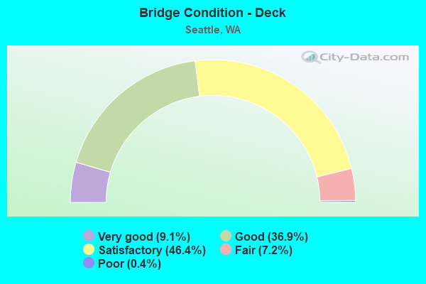
- Bridge Condition - Deck
- 9.1%Very good
- 36.9%Good
- 46.4%Satisfactory
- 7.2%Fair
- 0.4%Poor
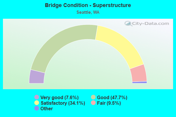
- Bridge Condition - Superstructure
- 7.6%Very good
- 47.7%Good
- 34.1%Satisfactory
- 9.5%Fair
- 1.1%Poor
- 0.4%Critical
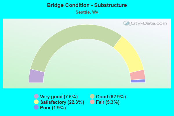
- Bridge Condition - Substructure
- 7.6%Very good
- 62.9%Good
- 22.3%Satisfactory
- 5.3%Fair
- 1.9%Poor
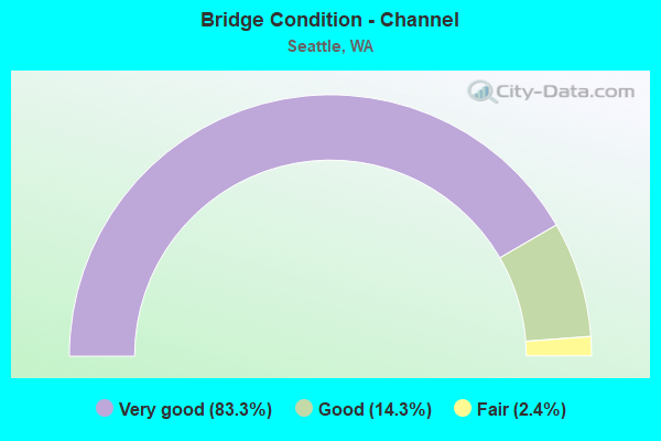
- Bridge Condition - Channel
- 83.3%Very good
- 14.3%Good
- 2.4%Fair
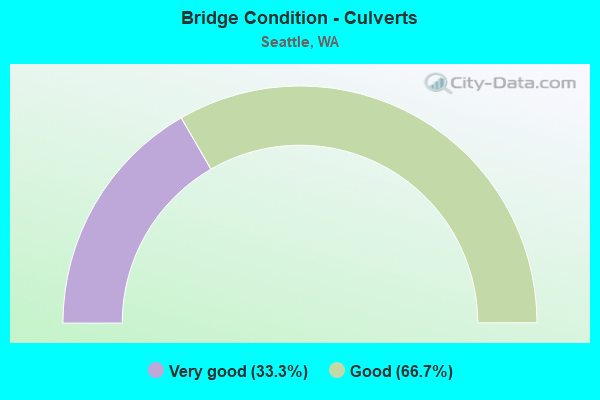
- Bridge Condition - Culverts
- 33.3%Very good
- 66.7%Good
Find on map >> Show street view
Structure Number: HH, Location: 0.2 N JCT SR 520 (Lat: 47.646917, Lng: -122.304611), Route carried "on" structure: State highway 513, Year Built: 1924, Year Reconstructed: 1999, Status: Posted for load, Structure Length: 10.49m (34.42ft), Average Daily Traffic: 65,696 (year 2019), Truck Traffic: 3%, Average Future Daily Traffic: 92,762 (year 2039), Features Intersected: MONTLAKE CUT
Minimum Vertical Clearance: 5.36m (17.59ft), Kilometerpoint: 0.306, Lanes on structure: 4, Base Highway Network: Yes, Owner: State Highway Agency, Approaching Roadway Width: 28.3m (92.8ft), Navigation Control: Yes ( Vertical Clearance: 9.1m (29.9ft), Horizontal Clearance: 45.7m (149.9ft)), Material/Design: Steel, Design/Construction: Movable - Bascule, Number Of Spans In Main Unit: 1, Number Of Approach Spans: 6, Length of Maximum Span: 47.5m (155.8ft), Curb or Sidewalk Widths: Left: 3.0m (9.8ft), Right: 3.0m (9.8ft), Curb-To-Curb Width: 12.2m (40.0ft), Out-to-Out Width: 18.3m (60.0ft)
Condition: Deck: Fair, Superstructure: Satisfactory, Substructure: Satisfactory, Channel: Very good, Operating Rating: 29.9 metric tons, Method Used To Determine Operating Rating: Load Factor (LF), Inventory Rating: 18.1 metric tons, Method Used To Determine Inventory Rating: Load Factor (LF), Structural Evaluation: Meets minimum limits, Deck Geometry: High priority of replacement, Waterway Adequacy: Equal to present desirable criteria, Approach Roadway Alignment: Equal to present desirable criteria, Bridge Posting: Required (Relationship of Operating Rating to Maximum Legal Load: 20.0 - 29.9% below), Length Of Structure Improvement: 10.49m (34.42ft), Designated Inspection Frequency: Every 24 months, Critical Feature Inspection Frequency: Every 24 months, Other Special Inspection Frequency: Every 24 months, Inspection Date: May 2020, Critical Feature Inspection Date: May 2020, Other Special Inspection Date: May 2020, Bridge Improvement Cost: $6,536,000, Roadway Improvement Cost: $1,307,000, Total Project Cost: $13,072,000 ( Estimate for 2014), Deck Structure Type: Open Grating, Wearing Surface/Protective System: Wearing Surface: Other
Find on map >> Show street view
Structure Number: IC, Location: 7.4 N JCT SR 509 (Lat: 47.639017, Lng: -122.345539), Route carried "on" structure: State highway 99, Year Built: 1930, Status: Open, Structure Length: 1.07m (3.51ft), Average Daily Traffic: 60,140 (year 2019), Truck Traffic: 4%, Average Future Daily Traffic: 84,917 (year 2039), Features Intersected: DEXTER WAY N
Minimum Vertical Clearance: 30+ m (98+ ft), Kilometerpoint: 54.508, Lanes on structure: 6, Lanes under structure: 1, Base Highway Network: Yes, Owner: State Highway Agency, Approaching Roadway Width: 24.4m (80.1ft), Skew: 32 degrees, Material/Design: Concrete, Design/Construction: Tee Beam, Number Of Spans In Main Unit: 1, Length of Maximum Span: 10.7m (35.1ft), Curb or Sidewalk Widths: Left: 3.7m (12.1ft), Right: 3.7m (12.1ft), Curb-To-Curb Width: 23.2m (76.1ft), Out-to-Out Width: 32.3m (106.0ft)
Condition: Deck: Good, Superstructure: Satisfactory, Substructure: Good, Operating Rating: 41.1 metric tons, Method Used To Determine Operating Rating: Load and Resistance Factor Rating (LRFR) rating reported by rating factor(RF) method using HL-93 loadings, Inventory Rating: 31.8 metric tons, Method Used To Determine Inventory Rating: Load and Resistance Factor Rating (LRFR) rating reported by rating factor(RF) method using HL-93 loadings, Structural Evaluation: Equal to present minimum criteria, Deck Geometry: High priority of replacement, Underclear: Meets minimum limits, Approach Roadway Alignment: Equal to present desirable criteria, Length Of Structure Improvement: 1.07m (3.51ft), Designated Inspection Frequency: Every 24 months, Inspection Date: March 2020, Bridge Improvement Cost: $574,000, Roadway Improvement Cost: $115,000, Total Project Cost: $1,148,000 ( Estimate for 2014), Deck Structure Type: Concrete Cast-file-Place, Wearing Surface/Protective System: Wearing Surface: Bituminous
Find on map >> Show street view
Structure Number: KN, Location: 1.9 E JCT I-5 (Lat: 47.590000, Lng: -122.283333), Route carried "on" structure: Interstate 90, Year Built: 1940, Year Reconstructed: 1992, Status: Open, Structure Length: 199.98m (656.10ft), Average Daily Traffic: 73,775 (year 2019), Truck Traffic: 4%, Average Future Daily Traffic: 104,170 (year 2039), Design Load: HS 20+Mod, Features Intersected: LAKE WASHINGTON
Minimum Vertical Clearance: 30+ m (98+ ft), Kilometerpoint: 6.888, Lanes on structure: 4, Base Highway Network: Yes, Owner: State Highway Agency, Approaching Roadway Width: 15.8m (51.8ft), Material/Design: Concrete, Number Of Spans In Main Unit: 1, Length of Maximum Span: 1999.8m (6,561.0ft), Curb-To-Curb Width: 17.1m (56.1ft), Out-to-Out Width: 18.3m (60.0ft)
Condition: Deck: Fair, Superstructure: Good, Substructure: Fair, Channel: Very good, Operating Rating: 22.4 metric tons, Method Used To Determine Operating Rating: Load and Resistance Factor Rating (LRFR) rating reported by rating factor(RF) method using HL-93 loadings, Inventory Rating: 17.2 metric tons, Method Used To Determine Inventory Rating: Load and Resistance Factor Rating (LRFR) rating reported by rating factor(RF) method using HL-93 loadings, Structural Evaluation: Meets minimum limits, Deck Geometry: Meets minimum limits, Waterway Adequacy: Equal to present desirable criteria, Approach Roadway Alignment: Equal to present desirable criteria, Length Of Structure Improvement: 199.98m (656.10ft), Designated Inspection Frequency: Every 24 months, Underwater Inspection Frequency: Every 24 months, Other Special Inspection Frequency: Every 12 months, Inspection Date: May 2021, Underwater Inspection Date: Febuary 2021, Other Special Inspection Date: November 2021, Bridge Improvement Cost: $70,859,000, Roadway Improvement Cost: $14,172,000, Total Project Cost: $141,718,000 ( Estimate for 2014), Deck Structure Type: Concrete Cast-file-Place, Wearing Surface/Protective System: Wearing Surface: Latex Concrete, Deck Protection: Epoxy Coated Reinforcing
Find on map >> Show street view
Structure Number: KO, Location: 2.3 E JCT I-5 (Lat: 47.589972, Lng: -122.287306), Route carried "on" structure: Interstate 90, Year Built: 1940, Year Reconstructed: 1992, Status: Open, Structure Length: 32.43m (106.40ft), Average Daily Traffic: 73,775 (year 2019), Truck Traffic: 4%, Average Future Daily Traffic: 104,170 (year 2039), Design Load: HS 20+Mod, Features Intersected: LAKE WASHINGTON
Minimum Vertical Clearance: 6.30m (20.67ft), Kilometerpoint: 6.888, Lanes on structure: 4, Lanes under structure: 2, Base Highway Network: Yes, Owner: State Highway Agency, Approaching Roadway Width: 20.4m (66.9ft), Navigation Control: Yes ( Vertical Clearance: 8.8m (28.9ft), Horizontal Clearance: 59.4m (194.9ft)), Material/Design: Steel, Design/Construction: Arch - Thru, Number Of Spans In Main Unit: 1, Number Of Approach Spans: 7, Length of Maximum Span: 65.5m (214.9ft), Curb-To-Curb Width: 15.8m (51.8ft), Out-to-Out Width: 16.8m (55.1ft)
Condition: Deck: Good, Superstructure: Fair, Substructure: Good, Channel: Very good, Operating Rating: 25.6 metric tons, Method Used To Determine Operating Rating: Load and Resistance Factor Rating (LRFR) rating reported by rating factor(RF) method using HL-93 loadings, Inventory Rating: 19.8 metric tons, Method Used To Determine Inventory Rating: Load and Resistance Factor Rating (LRFR) rating reported by rating factor(RF) method using HL-93 loadings, Structural Evaluation: Somewhat better than minimum adequacy, Deck Geometry: Meets minimum limits, Underclear: Meets minimum limits, Waterway Adequacy: Equal to present desirable criteria, Approach Roadway Alignment: Equal to present desirable criteria, Length Of Structure Improvement: 32.43m (106.40ft), Designated Inspection Frequency: Every 24 months, Critical Feature Inspection Frequency: Every 24 months, Underwater Inspection Frequency: Every 60 months, Inspection Date: May 2021, Critical Feature Inspection Date: May 2021, Underwater Inspection Date: May 2018, Bridge Improvement Cost: $14,683,000, Roadway Improvement Cost: $2,937,000, Total Project Cost: $29,366,000 ( Estimate for 2014), Deck Structure Type: Concrete Cast-file-Place, Wearing Surface/Protective System: Wearing Surface: Latex Concrete, Deck Protection: Epoxy Coated Reinforcing
Find on map >> Show street view
Structure Number: NV, Location: JCT SR 520 (Lat: 47.643969, Lng: -122.304200), Route carried "on" structure: State highway 513, Year Built: 1962, Status: Open, Structure Length: 4.63m (15.19ft), Average Daily Traffic: 36,456 (year 2019), Truck Traffic: 3%, Average Future Daily Traffic: 51,475 (year 2039), Design Load: HS 20, Features Intersected: SR 520
Minimum Vertical Clearance: 30+ m (98+ ft), Kilometerpoint: 0.001, Lanes on structure: 6, Lanes under structure: 7, Base Highway Network: Yes, Owner: State Highway Agency, Approaching Roadway Width: 25.6m (84.0ft), Skew: 20 degrees, Material/Design: Concrete continuous, Design/Construction: Box Beam or Girders - Multiple, Number Of Spans In Main Unit: 2, Length of Maximum Span: 26.8m (87.9ft), Curb or Sidewalk Widths: Left: 3.0m (9.8ft), Right: 3.0m (9.8ft), Curb-To-Curb Width: 23.2m (76.1ft), Out-to-Out Width: 39.3m (128.9ft)
Condition: Deck: Satisfactory, Superstructure: Satisfactory, Substructure: Good, Operating Rating: 89.8 metric tons, Method Used To Determine Operating Rating: Load Factor (LF), Inventory Rating: 54.4 metric tons, Method Used To Determine Inventory Rating: Load Factor (LF), Structural Evaluation: Equal to present minimum criteria, Deck Geometry: Meets minimum limits, Underclear: High priority of corrective action, Approach Roadway Alignment: Equal to present desirable criteria, Length Of Structure Improvement: 4.63m (15.19ft), Designated Inspection Frequency: Every 24 months, Inspection Date: May 2020, Bridge Improvement Cost: $2,614,000, Roadway Improvement Cost: $523,000, Total Project Cost: $5,229,000 ( Estimate for 2014), Deck Structure Type: Concrete Cast-file-Place, Wearing Surface/Protective System: Wearing Surface: Epoxy Overlay
Find on map >> Show street view
Structure Number: NW, Location: 0.1 E JCT SR 513 (Lat: 47.644219, Lng: -122.302033), Route carried "on" structure: City street 520, Year Built: 1962, Status: Open, Structure Length: 5.15m (16.90ft), Average Daily Traffic: 5,000 (year 2018), Truck Traffic: 3%, Average Future Daily Traffic: 7,000 (year 2038), Design Load: HS 20, Features Intersected: SR 520, Facility Carried by Structure: 24TH AVE
Minimum Vertical Clearance: 30+ m (98+ ft), Kilometerpoint: 0.080, Lanes on structure: 2, Lanes under structure: 5, Owner: State Highway Agency, Approaching Roadway Width: 12.8m (42.0ft), Material/Design: Concrete continuous, Design/Construction: Box Beam or Girders - Multiple, Number Of Spans In Main Unit: 2, Length of Maximum Span: 27.7m (90.9ft), Curb or Sidewalk Widths: Left: 4.9m (16.1ft), Right: 0.0m, Curb-To-Curb Width: 6.9m (22.6ft), Out-to-Out Width: 13.3m (43.6ft)
Condition: Deck: Good, Superstructure: Satisfactory, Substructure: Good, Operating Rating: 85.3 metric tons, Method Used To Determine Operating Rating: Load Factor (LF), Inventory Rating: 49.9 metric tons, Method Used To Determine Inventory Rating: Load Factor (LF), Structural Evaluation: Equal to present minimum criteria, Deck Geometry: High priority of replacement, Underclear: High priority of corrective action, Approach Roadway Alignment: Equal to present minimum criteria, Length Of Structure Improvement: 5.15m (16.90ft), Designated Inspection Frequency: Every 24 months, Inspection Date: August 2019, Bridge Improvement Cost: $1,487,000, Roadway Improvement Cost: $297,000, Total Project Cost: $2,974,000 ( Estimate for 2014), Deck Structure Type: Concrete Cast-file-Place, Wearing Surface/Protective System: Wearing Surface: Monolithic Concrete
Find on map >> Show street view
Structure Number: OC, Location: JCT I-5 (Lat: 47.592556, Lng: -122.324167), Route carried "on" structure: Ramp Interstate 90, Year Built: 1965, Year Reconstructed: 1991, Status: Open, Structure Length: 19.51m (64.01ft), Average Daily Traffic: 9,815 (year 2012), Truck Traffic: 5%, Average Future Daily Traffic: 16,411 (year 2036), Design Load: HS 20+Mod, Features Intersected: I-5/AIRPORT WAY RAMP
Minimum Vertical Clearance: 30+ m (98+ ft), Kilometerpoint: 0.001, Lanes on structure: 1, Lanes under structure: 10, Owner: State Highway Agency, Approaching Roadway Width: 7.0m (23.0ft), Material/Design: Prestressed concrete continuous, Design/Construction: Box Beam or Girders - Single/Spread, Number Of Spans In Main Unit: 2, Number Of Approach Spans: 5, Length of Maximum Span: 47.5m (155.8ft), Curb-To-Curb Width: 7.5m (24.6ft), Out-to-Out Width: 8.4m (27.6ft)
Condition: Deck: Good, Superstructure: Good, Substructure: Good, Operating Rating: 89.8 metric tons, Method Used To Determine Operating Rating: Load Factor (LF), Inventory Rating: 41.7 metric tons, Method Used To Determine Inventory Rating: Load Factor (LF), Structural Evaluation: Better than present minimum criteria, Deck Geometry: Better than present minimum criteria, Underclear: Equal to present minimum criteria, Approach Roadway Alignment: Equal to present desirable criteria, Length Of Structure Improvement: 19.51m (64.01ft), Designated Inspection Frequency: Every 24 months, Inspection Date: May 2021, Bridge Improvement Cost: $3,200,000, Roadway Improvement Cost: $640,000, Total Project Cost: $6,400,000 ( Estimate for 2014), Deck Structure Type: Concrete Cast-file-Place, Wearing Surface/Protective System: Wearing Surface: Latex Concrete
Find on map >> Show street view
Structure Number: 1447A, Location: 7.7 N JCT SR 509 (Lat: 47.643175, Lng: -122.347194), Route carried "on" structure: State highway 99, Year Built: 1931, Status: Open, Structure Length: 90.07m (295.51ft), Average Daily Traffic: 71,364 (year 2019), Truck Traffic: 4%, Average Future Daily Traffic: 100,765 (year 2039), Design Load: H 20, Features Intersected: LAKE UNION
Minimum Vertical Clearance: 30+ m (98+ ft), Kilometerpoint: 54.991, Lanes on structure: 6, Lanes under structure: 24, Base Highway Network: Yes, Owner: State Highway Agency, Approaching Roadway Width: 17.4m (57.1ft), Navigation Control: Yes ( Vertical Clearance: 41.1m (134.8ft), Horizontal Clearance: 237.7m (779.9ft)), Material/Design: Steel, Design/Construction: Truss - Deck, Number Of Spans In Main Unit: 8, Number Of Approach Spans: 15, Length of Maximum Span: 243.8m (799.9ft), Curb or Sidewalk Widths: Left: 1.5m (4.9ft), Right: 1.2m (3.9ft), Curb-To-Curb Width: 17.2m (56.4ft), Out-to-Out Width: 21.2m (69.6ft)
Condition: Deck: Satisfactory, Superstructure: Fair, Substructure: Satisfactory, Channel: Very good, Operating Rating: 34.5 metric tons, Method Used To Determine Operating Rating: Load Factor (LF), Inventory Rating: 20.9 metric tons, Method Used To Determine Inventory Rating: Load Factor (LF), Structural Evaluation: Somewhat better than minimum adequacy, Deck Geometry: High priority of replacement, Underclear: Somewhat better than minimum adequacy, Waterway Adequacy: Equal to present desirable criteria, Approach Roadway Alignment: Equal to present desirable criteria, Length Of Structure Improvement: 90.07m (295.51ft), Designated Inspection Frequency: Every 24 months, Critical Feature Inspection Frequency: Every 24 months, Underwater Inspection Frequency: Every 60 months, Other Special Inspection Frequency: Every 24 months, Inspection Date: August 2021, Critical Feature Inspection Date: August 2021, Underwater Inspection Date: July 2020, Other Special Inspection Date: August 2017, Bridge Improvement Cost: $34,869,000, Roadway Improvement Cost: $6,974,000, Total Project Cost: $69,738,000 ( Estimate for 2014), Deck Structure Type: Concrete Cast-file-Place, Wearing Surface/Protective System: Wearing Surface: Bituminous
Find on map >> Show street view
Structure Number: 1589A, Location: 8.3 N JCT SR 509 (Lat: 47.652508, Lng: -122.347350), Route carried "on" structure: State highway 99, Year Built: 1932, Status: Open, Structure Length: 2.83m (9.28ft), Average Daily Traffic: 71,364 (year 2019), Truck Traffic: 4%, Average Future Daily Traffic: 100,765 (year 2039), Features Intersected: N 38TH ST
Minimum Vertical Clearance: 30+ m (98+ ft), Kilometerpoint: 56.037, Lanes on structure: 5, Lanes under structure: 4, Base Highway Network: Yes, Owner: State Highway Agency, Approaching Roadway Width: 17.4m (57.1ft), Skew: 20 degrees, Material/Design: Concrete continuous, Design/Construction: Tee Beam, Number Of Spans In Main Unit: 3, Length of Maximum Span: 15.8m (51.8ft), Curb or Sidewalk Widths: Left: 1.5m (4.9ft), Right: 1.5m (4.9ft), Curb-To-Curb Width: 17.4m (57.1ft), Out-to-Out Width: 21.2m (69.6ft)
Condition: Deck: Good, Superstructure: Fair, Substructure: Satisfactory, Operating Rating: 24.0 metric tons, Method Used To Determine Operating Rating: Load and Resistance Factor Rating (LRFR) rating reported by rating factor(RF) method using HL-93 loadings, Inventory Rating: 18.5 metric tons, Method Used To Determine Inventory Rating: Load and Resistance Factor Rating (LRFR) rating reported by rating factor(RF) method using HL-93 loadings, Structural Evaluation: Meets minimum limits, Deck Geometry: High priority of replacement, Underclear: High priority of corrective action, Approach Roadway Alignment: Equal to present desirable criteria, Length Of Structure Improvement: 2.83m (9.28ft), Designated Inspection Frequency: Every 24 months, Inspection Date: March 2020, Bridge Improvement Cost: $1,098,000, Roadway Improvement Cost: $220,000, Total Project Cost: $2,195,000 ( Estimate for 2014), Deck Structure Type: Concrete Cast-file-Place, Wearing Surface/Protective System: Wearing Surface: Bituminous
Find on map >> Show street view
Structure Number: 1669A, Location: 9.0 N JCT SR 509 (Lat: 47.661908, Lng: -122.347342), Route carried "on" structure: State highway 99, Year Built: 1933, Status: Open, Structure Length: 2.80m (9.19ft), Average Daily Traffic: 47,042 (year 2019), Truck Traffic: 3%, Average Future Daily Traffic: 66,423 (year 2039), Features Intersected: N 46TH ST
Minimum Vertical Clearance: 30+ m (98+ ft), Kilometerpoint: 57.067, Lanes on structure: 6, Lanes under structure: 4, Base Highway Network: Yes, Owner: State Highway Agency, Approaching Roadway Width: 25.3m (83.0ft), Skew: 30 degrees, Material/Design: Concrete continuous, Design/Construction: Tee Beam, Number Of Spans In Main Unit: 3, Length of Maximum Span: 15.8m (51.8ft), Curb or Sidewalk Widths: Left: 2.4m (7.9ft), Right: 2.4m (7.9ft), Curb-To-Curb Width: 23.2m (76.1ft), Out-to-Out Width: 29.4m (96.5ft)
Condition: Deck: Good, Superstructure: Satisfactory, Substructure: Satisfactory, Operating Rating: 26.6 metric tons, Method Used To Determine Operating Rating: Load and Resistance Factor Rating (LRFR) rating reported by rating factor(RF) method using HL-93 loadings, Inventory Rating: 20.7 metric tons, Method Used To Determine Inventory Rating: Load and Resistance Factor Rating (LRFR) rating reported by rating factor(RF) method using HL-93 loadings, Structural Evaluation: Somewhat better than minimum adequacy, Deck Geometry: High priority of replacement, Underclear: Meets minimum limits, Approach Roadway Alignment: Equal to present desirable criteria, Length Of Structure Improvement: 2.80m (9.19ft), Designated Inspection Frequency: Every 24 months, Inspection Date: March 2020, Bridge Improvement Cost: $1,564,000, Roadway Improvement Cost: $313,000, Total Project Cost: $3,128,000 ( Estimate for 2014), Deck Structure Type: Concrete Cast-file-Place, Wearing Surface/Protective System: Wearing Surface: Bituminous
Find on map >> Show street view
Structure Number: 1673A, Location: 9.8 N JCT SR 509 (Lat: 47.674161, Lng: -122.347222), Route carried "on" structure: State highway 99, Year Built: 1932, Status: Open, Structure Length: 2.23m (7.32ft), Average Daily Traffic: 33,847 (year 2019), Truck Traffic: 3%, Average Future Daily Traffic: 47,791 (year 2039), Features Intersected: N 63RD ST
Minimum Vertical Clearance: 30+ m (98+ ft), Kilometerpoint: 58.403, Lanes on structure: 6, Lanes under structure: 2, Base Highway Network: Yes, Owner: State Highway Agency, Approaching Roadway Width: 18.3m (60.0ft), Skew: 24 degrees, Material/Design: Concrete continuous, Design/Construction: Slab, Number Of Spans In Main Unit: 2, Length of Maximum Span: 15.5m (50.9ft), Curb or Sidewalk Widths: Left: 2.1m (6.9ft), Right: 2.1m (6.9ft), Curb-To-Curb Width: 18.6m (61.0ft), Out-to-Out Width: 24.1m (79.1ft)
Condition: Deck: Satisfactory, Superstructure: Satisfactory, Substructure: Satisfactory, Operating Rating: 49.0 metric tons, Method Used To Determine Operating Rating: Load Factor (LF), Inventory Rating: 26.3 metric tons, Method Used To Determine Inventory Rating: Load Factor (LF), Structural Evaluation: Equal to present minimum criteria, Deck Geometry: High priority of replacement, Underclear: High priority of corrective action, Approach Roadway Alignment: Equal to present desirable criteria, Length Of Structure Improvement: 2.23m (7.32ft), Designated Inspection Frequency: Every 24 months, Inspection Date: June 2021, Bridge Improvement Cost: $905,000, Roadway Improvement Cost: $181,000, Total Project Cost: $1,810,000 ( Estimate for 2014), Deck Structure Type: Concrete Cast-file-Place, Wearing Surface/Protective System: Wearing Surface: Bituminous
Find on map >> Show street view
Structure Number: 1684A, Location: 9.2 N JCT SR 509 (Lat: 47.665022, Lng: -122.347314), Route carried "on" structure: State highway 99, Year Built: 1933, Status: Open, Structure Length: 1.34m (4.40ft), Average Daily Traffic: 40,996 (year 2019), Truck Traffic: 3%, Average Future Daily Traffic: 57,886 (year 2039), Features Intersected: N 50TH ST
Minimum Vertical Clearance: 30+ m (98+ ft), Kilometerpoint: 57.437, Lanes on structure: 5, Lanes under structure: 2, Base Highway Network: Yes, Owner: State Highway Agency, Approaching Roadway Width: 25.3m (83.0ft), Skew: 20 degrees, Material/Design: Concrete, Design/Construction: Tee Beam, Number Of Spans In Main Unit: 1, Length of Maximum Span: 12.8m (42.0ft), Curb or Sidewalk Widths: Left: 2.1m (6.9ft), Right: 2.1m (6.9ft), Curb-To-Curb Width: 19.8m (65.0ft), Out-to-Out Width: 24.8m (81.4ft)
Condition: Deck: Satisfactory, Superstructure: Fair, Substructure: Good, Operating Rating: 45.4 metric tons, Method Used To Determine Operating Rating: Load Factor (LF), Inventory Rating: 27.2 metric tons, Method Used To Determine Inventory Rating: Load Factor (LF), Structural Evaluation: Somewhat better than minimum adequacy, Deck Geometry: High priority of replacement, Underclear: High priority of corrective action, Approach Roadway Alignment: Equal to present desirable criteria, Length Of Structure Improvement: 1.34m (4.40ft), Designated Inspection Frequency: Every 24 months, Inspection Date: March 2020, Bridge Improvement Cost: $748,000, Roadway Improvement Cost: $150,000, Total Project Cost: $1,496,000 ( Estimate for 2014), Deck Structure Type: Concrete Cast-file-Place, Wearing Surface/Protective System: Wearing Surface: Bituminous
Find on map >> Show street view
Structure Number: 4872A, Location: 0.1 N JCT SR 509 (Lat: 47.537583, Lng: -122.334694), Route carried "on" structure: State highway 99, Year Built: 1956, Year Reconstructed: 1998, Status: Open, Structure Length: 91.74m (300.98ft), Average Daily Traffic: 51,317 (year 2019), Truck Traffic: 9%, Average Future Daily Traffic: 72,459 (year 2039), Design Load: HS 20+Mod, Features Intersected: DUWAMISH RIVER
Minimum Vertical Clearance: 30+ m (98+ ft), Kilometerpoint: 42.728, Lanes on structure: 3, Lanes under structure: 14, Base Highway Network: Yes, Owner: State Highway Agency, Approaching Roadway Width: 18.0m (59.1ft), Navigation Control: Yes ( Vertical Clearance: 12.5m (41.0ft), Horizontal Clearance: 45.7m (149.9ft)), Material/Design: Steel, Design/Construction: Movable - Bascule, Number Of Spans In Main Unit: 1, Number Of Approach Spans: 23, Length of Maximum Span: 84.4m (276.9ft), Curb or Sidewalk Widths: Left: 0.0m, Right: 2.3m (7.5ft), Curb-To-Curb Width: 13.4m (44.0ft), Out-to-Out Width: 17.7m (58.1ft)
Condition: Deck: Fair, Superstructure: Satisfactory, Substructure: Satisfactory, Channel: Good, Operating Rating: 41.7 metric tons, Method Used To Determine Operating Rating: Load Factor (LF), Inventory Rating: 25.4 metric tons, Method Used To Determine Inventory Rating: Load Factor (LF), Structural Evaluation: Equal to present minimum criteria, Deck Geometry: Meets minimum limits, Underclear: High priority of corrective action, Waterway Adequacy: Equal to present desirable criteria, Approach Roadway Alignment: Equal to present desirable criteria, Length Of Structure Improvement: 91.74m (300.98ft), Designated Inspection Frequency: Every 24 months, Critical Feature Inspection Frequency: Every 24 months, Underwater Inspection Frequency: Every 60 months, Other Special Inspection Frequency: Every 24 months, Inspection Date: September 2020, Critical Feature Inspection Date: September 2020, Underwater Inspection Date: June 2017, Other Special Inspection Date: September 2020, Bridge Improvement Cost: $36,722,000, Roadway Improvement Cost: $7,344,000, Total Project Cost: $73,444,000 ( Estimate for 2014), Deck Structure Type: Open Grating
Find on map >> Show street view
Structure Number: 5714A, Location: 3.0 W SR 509 (Lat: 47.523222, Lng: -122.393806), Route carried "on" structure: State highway 160, Year Built: 1957, Year Reconstructed: 2002, Status: Posted for load, Structure Length: 17.01m (55.81ft), Average Daily Traffic: 9,721 (year 2010), Truck Traffic: 1%, Average Future Daily Traffic: 15,281 (year 2036), Design Load: H 15, Features Intersected: PUGET SOUND @ FAUNTLEROY
Minimum Vertical Clearance: 30+ m (98+ ft), Kilometerpoint: 12.022, Lanes on structure: 2, Toll: Toll bridge, Owner: State Highway Agency, Approaching Roadway Width: 11.6m (38.1ft), Material/Design: Wood or Timber, Design/Construction: Stringer/Multi-beam, Number Of Spans In Main Unit: 37, Length of Maximum Span: 4.9m (16.1ft), Curb or Sidewalk Widths: Left: 0.2m (0.7ft), Right: 2.0m (6.6ft), Curb-To-Curb Width: 11.4m (37.4ft), Out-to-Out Width: 20.4m (66.9ft)
Condition: Deck: Satisfactory, Superstructure: Fair, Substructure: Fair, Channel: Very good, Operating Rating: 30.8 metric tons, Method Used To Determine Operating Rating: Allowable Stress (AS), Inventory Rating: 21.8 metric tons, Method Used To Determine Inventory Rating: Allowable Stress (AS), Structural Evaluation: Somewhat better than minimum adequacy, Deck Geometry: Meets minimum limits, Waterway Adequacy: Equal to present desirable criteria, Approach Roadway Alignment: Equal to present desirable criteria, Length Of Structure Improvement: 17.01m (55.81ft), Designated Inspection Frequency: Every 12 months, Underwater Inspection Frequency: Every 48 months, Inspection Date: June 2021, Underwater Inspection Date: November 2020, Bridge Improvement Cost: $4,464,000, Roadway Improvement Cost: $893,000, Total Project Cost: $8,928,000 ( Estimate for 2014), Deck Structure Type: Wood or Timber, Wearing Surface/Protective System: Wearing Surface: Bituminous
Find on map >> Show street view
Structure Number: 5758A, Location: 2.1 N JCT SR 509 (Lat: 47.567528, Lng: -122.339417), Route carried "on" structure: State highway 99, Year Built: 1959, Year Reconstructed: 2013, Status: Posted for load, Structure Length: 85.10m (279.20ft), Average Daily Traffic: 43,115 (year 2019), Truck Traffic: 4%, Average Future Daily Traffic: 60,878 (year 2039), Design Load: HS 20, Features Intersected: SPOKANE ST
Minimum Vertical Clearance: 30+ m (98+ ft), Kilometerpoint: 46.140, Lanes on structure: 4, Lanes under structure: 23, Base Highway Network: Yes, Owner: State Highway Agency, Approaching Roadway Width: 23.8m (78.1ft), Skew: 30 degrees, Material/Design: Steel, Design/Construction: Stringer/Multi-beam, Number Of Spans In Main Unit: 3, Number Of Approach Spans: 41, Length of Maximum Span: 41.1m (134.8ft), Curb-To-Curb Width: 23.2m (76.1ft), Out-to-Out Width: 25.6m (84.0ft)
Condition: Deck: Satisfactory, Superstructure: Satisfactory, Substructure: Satisfactory, Operating Rating: 32.7 metric tons, Method Used To Determine Operating Rating: Load Factor (LF), Inventory Rating: 19.0 metric tons, Method Used To Determine Inventory Rating: Load Factor (LF), Structural Evaluation: Meets minimum limits, Deck Geometry: Superior to present desirable criteria, Underclear: Meets minimum limits, Approach Roadway Alignment: Equal to present desirable criteria, Bridge Posting: Required (Relationship of Operating Rating to Maximum Legal Load: 10.0 - 19.9% below), Length Of Structure Improvement: 85.10m (279.20ft), Designated Inspection Frequency: Every 24 months, Critical Feature Inspection Frequency: Every 24 months, Inspection Date: October 2021, Critical Feature Inspection Date: October 2021, Bridge Improvement Cost: $44,672,000, Roadway Improvement Cost: $8,934,000, Total Project Cost: $89,344,000 ( Estimate for 2014), Deck Structure Type: Concrete Cast-file-Place, Wearing Surface/Protective System: Wearing Surface: Monolithic Concrete
Find on map >> Show street view
Structure Number: 6046B, Location: 2.5 N JCT SR 599 (Lat: 47.526417, Lng: -122.324139), Route carried "on" structure: State highway 99, Year Built: 1959, Status: Open, Structure Length: 2.62m (8.60ft), Average Daily Traffic: 31,527 (year 2019), Truck Traffic: 15%, Average Future Daily Traffic: 44,516 (year 2039), Design Load: HS 20+Mod, Features Intersected: CLOVERDALE ST
Minimum Vertical Clearance: 30+ m (98+ ft), Kilometerpoint: 40.861, Lanes on structure: 4, Lanes under structure: 3, Base Highway Network: Yes, Owner: State Highway Agency, Approaching Roadway Width: 35.4m (116.1ft), Skew: 33 degrees, Material/Design: Prestressed concrete, Design/Construction: Stringer/Multi-beam, Number Of Spans In Main Unit: 1, Length of Maximum Span: 25.6m (84.0ft), Curb-To-Curb Width: 35.4m (116.1ft), Out-to-Out Width: 36.6m (120.1ft)
Condition: Deck: Good, Superstructure: Satisfactory, Substructure: Good, Operating Rating: 76.2 metric tons, Method Used To Determine Operating Rating: Load Factor (LF), Inventory Rating: 45.4 metric tons, Method Used To Determine Inventory Rating: Load Factor (LF), Structural Evaluation: Equal to present minimum criteria, Deck Geometry: Superior to present desirable criteria, Underclear: Equal to present minimum criteria, Approach Roadway Alignment: Equal to present desirable criteria, Length Of Structure Improvement: 2.62m (8.60ft), Designated Inspection Frequency: Every 24 months, Inspection Date: March 2020, Bridge Improvement Cost: $2,030,000, Roadway Improvement Cost: $406,000, Total Project Cost: $4,059,000 ( Estimate for 2014), Deck Structure Type: Concrete Cast-file-Place, Wearing Surface/Protective System: Wearing Surface: Bituminous, Membrane: Preformed Fabric
Find on map >> Show street view
Structure Number: 6054A, Location: 2.4 N JCT SR 509 (Lat: 47.571411, Lng: -122.339042), Route carried "on" structure: Ramp State highway 99, Year Built: 1959, Status: Posted for load, Structure Length: 33.95m (111.38ft), Average Daily Traffic: 13,788 (year 2019), Truck Traffic: 5%, Average Future Daily Traffic: 19,468 (year 2039), Design Load: HS 20, Features Intersected: CITY STREET, NPRR, Facility Carried by Structure: E-N RAMP
Minimum Vertical Clearance: 30+ m (98+ ft), Kilometerpoint: 0.418, Lanes on structure: 1, Lanes under structure: 2, Owner: State Highway Agency, Approaching Roadway Width: 10.4m (34.1ft), Material/Design: Concrete continuous, Design/Construction: Tee Beam, Number Of Spans In Main Unit: 12, Number Of Approach Spans: 6, Length of Maximum Span: 24.4m (80.1ft), Curb-To-Curb Width: 6.4m (21.0ft), Out-to-Out Width: 8.0m (26.2ft)
Condition: Deck: Satisfactory, Superstructure: Satisfactory, Substructure: Satisfactory, Operating Rating: 19.1 metric tons, Method Used To Determine Operating Rating: Load and Resistance Factor Rating (LRFR) rating reported by rating factor(RF) method using HL-93 loadings, Inventory Rating: 14.9 metric tons, Method Used To Determine Inventory Rating: Load and Resistance Factor Rating (LRFR) rating reported by rating factor(RF) method using HL-93 loadings, Structural Evaluation: High priority of corrective action, Deck Geometry: Somewhat better than minimum adequacy, Underclear: High priority of corrective action, Approach Roadway Alignment: Equal to present minimum criteria, Bridge Posting: Required (Relationship of Operating Rating to Maximum Legal Load: 20.0 - 29.9% below), Length Of Structure Improvement: 33.95m (111.38ft), Designated Inspection Frequency: Every 24 months, Inspection Date: September 2020, Bridge Improvement Cost: $9,524,000, Roadway Improvement Cost: $1,905,000, Total Project Cost: $19,049,000 ( Estimate for 2022), Deck Structure Type: Concrete Cast-file-Place, Wearing Surface/Protective System: Wearing Surface: Monolithic Concrete
Find on map >> Show street view
Structure Number: 6080A, Location: 0.7 N JCT SR 520 (Lat: 47.646297, Lng: -122.322458), Route carried "on" structure: Interstate 5, Year Built: 1962, Status: Open, Structure Length: 135.00m (442.91ft), Average Daily Traffic: 187,355 (year 2019), Truck Traffic: 5%, Average Future Daily Traffic: 264,545 (year 2039), Design Load: HS 20, Features Intersected: LAKE WASH SHIP CANAL
Minimum Vertical Clearance: 30+ m (98+ ft), Kilometerpoint: 270.917, Lanes on structure: 12, Lanes under structure: 14, Base Highway Network: Yes, Owner: State Highway Agency, Approaching Roadway Width: 44.5m (146.0ft), Skew: 30 degrees, Navigation Control: Yes ( Vertical Clearance: 39.0m (128.0ft), Horizontal Clearance: 76.2m (250.0ft)), Material/Design: Steel continuous, Design/Construction: Truss - Deck, Number Of Spans In Main Unit: 6, Number Of Approach Spans: 28, Length of Maximum Span: 168.2m (551.8ft), Curb-To-Curb Width: 53.0m (173.9ft), Out-to-Out Width: 55.5m (182.1ft)
Condition: Deck: Satisfactory, Superstructure: Satisfactory, Substructure: Good, Channel: Very good, Operating Rating: 28.8 metric tons, Method Used To Determine Operating Rating: Load and Resistance Factor Rating (LRFR) rating reported by rating factor(RF) method using HL-93 loadings, Inventory Rating: 22.4 metric tons, Method Used To Determine Inventory Rating: Load and Resistance Factor Rating (LRFR) rating reported by rating factor(RF) method using HL-93 loadings, Structural Evaluation: Somewhat better than minimum adequacy, Deck Geometry: Somewhat better than minimum adequacy, Underclear: High priority of corrective action, Waterway Adequacy: Equal to present desirable criteria, Approach Roadway Alignment: Equal to present desirable criteria, Length Of Structure Improvement: 135.00m (442.91ft), Designated Inspection Frequency: Every 24 months, Critical Feature Inspection Frequency: Every 24 months, Inspection Date: July 2021, Critical Feature Inspection Date: July 2021, Bridge Improvement Cost: $155,680,000, Roadway Improvement Cost: $31,136,000, Total Project Cost: $311,359,000 ( Estimate for 2022), Deck Structure Type: Concrete Cast-file-Place, Wearing Surface/Protective System: Wearing Surface: Latex Concrete
Find on map >> Show street view
Structure Number: 6085A, Location: 4.6 N JCT I-90 (Lat: 47.656778, Lng: -122.321942), Route carried "on" structure: Ramp Interstate 5, Year Built: 1962, Status: Open, Structure Length: 8.32m (27.30ft), Average Daily Traffic: 3,156 (year 2019), Truck Traffic: 1%, Average Future Daily Traffic: 4,456 (year 2039), Design Load: HS 20, Features Intersected: PASADENA PL NE, Facility Carried by Structure: EXP N TO 42ND RAMP
Minimum Vertical Clearance: 30+ m (98+ ft), Kilometerpoint: 0.145, Lanes on structure: 1, Lanes under structure: 2, Owner: State Highway Agency, Approaching Roadway Width: 6.7m (22.0ft), Material/Design: Concrete continuous, Design/Construction: Box Beam or Girders - Multiple, Number Of Spans In Main Unit: 4, Length of Maximum Span: 31.7m (104.0ft), Curb-To-Curb Width: 6.7m (22.0ft), Out-to-Out Width: 8.2m (26.9ft)
Condition: Deck: Very good, Superstructure: Good, Substructure: Good, Operating Rating: 27.9 metric tons, Method Used To Determine Operating Rating: Load and Resistance Factor Rating (LRFR) rating reported by rating factor(RF) method using HL-93 loadings, Inventory Rating: 21.4 metric tons, Method Used To Determine Inventory Rating: Load and Resistance Factor Rating (LRFR) rating reported by rating factor(RF) method using HL-93 loadings, Structural Evaluation: Somewhat better than minimum adequacy, Deck Geometry: Equal to present minimum criteria, Underclear: Meets minimum limits, Approach Roadway Alignment: Equal to present desirable criteria, Length Of Structure Improvement: 8.32m (27.30ft), Designated Inspection Frequency: Every 24 months, Inspection Date: May 2021, Bridge Improvement Cost: $1,310,000, Roadway Improvement Cost: $262,000, Total Project Cost: $2,621,000 ( Estimate for 2014), Deck Structure Type: Concrete Cast-file-Place, Wearing Surface/Protective System: Wearing Surface: Latex Concrete
Find on map >> Show street view
Structure Number: 6111A, Location: 1.3 N JCT SR 520 (Lat: 47.661333, Lng: -122.322639), Route carried "on" structure: City street , Year Built: 1960, Status: Open, Structure Length: 7.35m (24.11ft), Average Daily Traffic: 28,856 (year 2012), Truck Traffic: 5%, Average Future Daily Traffic: 46,170 (year 2036), Design Load: HS 20, Features Intersected: I-5, Facility Carried by Structure: NE 45TH ST
Minimum Vertical Clearance: 30+ m (98+ ft), Kilometerpoint: 0.032, Lanes on structure: 6, Lanes under structure: 13, Base Highway Network: Yes, Owner: State Highway Agency, Approaching Roadway Width: 17.7m (58.1ft), Material/Design: Concrete continuous, Design/Construction: Box Beam or Girders - Multiple, Number Of Spans In Main Unit: 3, Length of Maximum Span: 28.7m (94.2ft), Curb or Sidewalk Widths: Left: 2.4m (7.9ft), Right: 2.4m (7.9ft), Curb-To-Curb Width: 18.6m (61.0ft), Out-to-Out Width: 24.1m (79.1ft)
Condition: Deck: Satisfactory, Superstructure: Good, Substructure: Good, Operating Rating: 49.9 metric tons, Method Used To Determine Operating Rating: Load and Resistance Factor Rating (LRFR) rating reported by rating factor(RF) method using HL-93 loadings, Inventory Rating: 38.6 metric tons, Method Used To Determine Inventory Rating: Load and Resistance Factor Rating (LRFR) rating reported by rating factor(RF) method using HL-93 loadings, Structural Evaluation: Better than present minimum criteria, Deck Geometry: High priority of replacement, Underclear: High priority of corrective action, Approach Roadway Alignment: Equal to present desirable criteria, Length Of Structure Improvement: 7.35m (24.11ft), Designated Inspection Frequency: Every 24 months, Inspection Date: June 2018, Bridge Improvement Cost: $2,892,000, Roadway Improvement Cost: $578,000, Total Project Cost: $5,784,000 ( Estimate for 2014), Deck Structure Type: Concrete Cast-file-Place, Wearing Surface/Protective System: Wearing Surface: Monolithic Concrete
Find on map >> Show street view
Structure Number: 6111B, Location: 1.6 N JCT SR 520 (Lat: 47.664972, Lng: -122.322528), Route carried "on" structure: City street , Year Built: 1962, Status: Open, Structure Length: 7.35m (24.11ft), Average Daily Traffic: 26,500 (year 2016), Truck Traffic: 5%, Average Future Daily Traffic: 38,000 (year 2036), Design Load: HS 15, Features Intersected: I-5, Facility Carried by Structure: NE 50TH ST
Minimum Vertical Clearance: 30+ m (98+ ft), Kilometerpoint: 0.032, Lanes on structure: 5, Lanes under structure: 12, Base Highway Network: Yes, Owner: State Highway Agency, Approaching Roadway Width: 18.6m (61.0ft), Material/Design: Concrete continuous, Design/Construction: Box Beam or Girders - Multiple, Number Of Spans In Main Unit: 3, Length of Maximum Span: 30.8m (101.0ft), Curb or Sidewalk Widths: Left: 2.4m (7.9ft), Right: 2.4m (7.9ft), Curb-To-Curb Width: 18.6m (61.0ft), Out-to-Out Width: 24.4m (80.1ft)
Condition: Deck: Good, Superstructure: Satisfactory, Substructure: Good, Operating Rating: 58.0 metric tons, Method Used To Determine Operating Rating: Load Factor (LF), Inventory Rating: 34.5 metric tons, Method Used To Determine Inventory Rating: Load Factor (LF), Structural Evaluation: Equal to present minimum criteria, Deck Geometry: High priority of corrective action, Underclear: High priority of corrective action, Approach Roadway Alignment: Equal to present desirable criteria, Length Of Structure Improvement: 7.35m (24.11ft), Designated Inspection Frequency: Every 24 months, Inspection Date: May 2021, Bridge Improvement Cost: $3,036,000, Roadway Improvement Cost: $607,000, Total Project Cost: $6,073,000 ( Estimate for 2014), Deck Structure Type: Concrete Cast-file-Place, Wearing Surface/Protective System: Wearing Surface: Monolithic Concrete
Find on map >> Show street view
Structure Number: 6286A, Location: 2.3 N JCT SR 520 (Lat: 47.673889, Lng: -122.320917), Route carried "on" structure: Interstate 5, Year Built: 1961, Status: Open, Structure Length: 40.39m (132.51ft), Average Daily Traffic: 93,064 (year 2019), Truck Traffic: 5%, Average Future Daily Traffic: 131,406 (year 2039), Design Load: HS 20+Mod, Features Intersected: RAVENNA BLVD
Minimum Vertical Clearance: 30+ m (98+ ft), Kilometerpoint: 273.991, Lanes on structure: 4, Lanes under structure: 8, Base Highway Network: Yes, Owner: State Highway Agency, Approaching Roadway Width: 18.3m (60.0ft), Skew: 6 degrees, Material/Design: Prestressed concrete, Design/Construction: Stringer/Multi-beam, Number Of Spans In Main Unit: 20, Length of Maximum Span: 30.2m (99.1ft), Curb-To-Curb Width: 18.9m (62.0ft), Out-to-Out Width: 19.8m (65.0ft)
Condition: Deck: Satisfactory, Superstructure: Satisfactory, Substructure: Satisfactory, Operating Rating: 53.5 metric tons, Method Used To Determine Operating Rating: Load Factor (LF), Inventory Rating: 31.7 metric tons, Method Used To Determine Inventory Rating: Load Factor (LF), Structural Evaluation: Equal to present minimum criteria, Deck Geometry: Meets minimum limits, Underclear: Meets minimum limits, Approach Roadway Alignment: Equal to present desirable criteria, Length Of Structure Improvement: 40.39m (132.51ft), Designated Inspection Frequency: Every 48 months, Inspection Date: June 2018, Bridge Improvement Cost: $16,430,000, Roadway Improvement Cost: $3,286,000, Total Project Cost: $32,860,000 ( Estimate for 2014), Deck Structure Type: Concrete Cast-file-Place, Wearing Surface/Protective System: Wearing Surface: Latex Concrete
Find on map >> Show street view
Structure Number: 6286B, Location: 2.3 N JCT SR 520 (Lat: 47.674333, Lng: -122.321444), Route carried "on" structure: Interstate 5, Year Built: 1961, Status: Open, Structure Length: 41.82m (137.20ft), Average Daily Traffic: 93,064 (year 2019), Truck Traffic: 5%, Average Future Daily Traffic: 131,406 (year 2039), Design Load: HS 20+Mod, Features Intersected: RAVENNA BLVD
Minimum Vertical Clearance: 30+ m (98+ ft), Kilometerpoint: 273.991, Lanes on structure: 4, Lanes under structure: 8, Base Highway Network: Yes, Owner: State Highway Agency, Approaching Roadway Width: 18.3m (60.0ft), Skew: 6 degrees, Material/Design: Prestressed concrete, Design/Construction: Stringer/Multi-beam, Number Of Spans In Main Unit: 20, Length of Maximum Span: 31.7m (104.0ft), Curb-To-Curb Width: 18.3m (60.0ft), Out-to-Out Width: 19.8m (65.0ft)
Condition: Deck: Satisfactory, Superstructure: Satisfactory, Substructure: Satisfactory, Operating Rating: 51.7 metric tons, Method Used To Determine Operating Rating: Load Factor (LF), Inventory Rating: 30.8 metric tons, Method Used To Determine Inventory Rating: Load Factor (LF), Structural Evaluation: Equal to present minimum criteria, Deck Geometry: Meets minimum limits, Underclear: Somewhat better than minimum adequacy, Approach Roadway Alignment: Equal to present desirable criteria, Length Of Structure Improvement: 41.82m (137.20ft), Designated Inspection Frequency: Every 48 months, Inspection Date: June 2018, Bridge Improvement Cost: $17,013,000, Roadway Improvement Cost: $3,403,000, Total Project Cost: $34,026,000 ( Estimate for 2014), Deck Structure Type: Concrete Cast-file-Place, Wearing Surface/Protective System: Wearing Surface: Epoxy Overlay
Find on map >> Show street view
Structure Number: 6286C, Location: 5.8 N JCT I-90 (Lat: 47.673972, Lng: -122.321139), Route carried "on" structure: Ramp Interstate 5, Year Built: 1961, Status: Open, Structure Length: 41.12m (134.91ft), Average Daily Traffic: 43,394 (year 2019), Truck Traffic: 5%, Average Future Daily Traffic: 61,272 (year 2039), Design Load: HS 20+Mod, Features Intersected: RAVENNA BLVD
Minimum Vertical Clearance: 30+ m (98+ ft), Kilometerpoint: 274.023, Lanes on structure: 3, Lanes under structure: 8, Owner: State Highway Agency, Approaching Roadway Width: 15.2m (49.9ft), Skew: 13 degrees, Material/Design: Prestressed concrete, Design/Construction: Stringer/Multi-beam, Number Of Spans In Main Unit: 20, Length of Maximum Span: 29.0m (95.1ft), Curb-To-Curb Width: 14.6m (47.9ft), Out-to-Out Width: 16.2m (53.1ft)
Condition: Deck: Satisfactory, Superstructure: Satisfactory, Substructure: Satisfactory, Operating Rating: 56.2 metric tons, Method Used To Determine Operating Rating: Load Factor (LF), Inventory Rating: 33.6 metric tons, Method Used To Determine Inventory Rating: Load Factor (LF), Structural Evaluation: Equal to present minimum criteria, Deck Geometry: Better than present minimum criteria, Underclear: Meets minimum limits, Approach Roadway Alignment: Equal to present desirable criteria, Length Of Structure Improvement: 41.12m (134.91ft), Designated Inspection Frequency: Every 48 months, Inspection Date: June 2018, Bridge Improvement Cost: $14,030,000, Roadway Improvement Cost: $2,806,000, Total Project Cost: $28,059,000 ( Estimate for 2014), Deck Structure Type: Concrete Cast-file-Place, Wearing Surface/Protective System: Wearing Surface: Latex Concrete
Find on map >> Show street view
Structure Number: 6303A, Location: 2.9 N JCT I-90 (Lat: 47.632111, Lng: -122.324194), Route carried "on" structure: Interstate 5, Year Built: 1961, Status: Open, Structure Length: 50.93m (167.09ft), Average Daily Traffic: 108,083 (year 2019), Truck Traffic: 5%, Average Future Daily Traffic: 152,613 (year 2039), Design Load: HS 20, Features Intersected: GALER-LAKEVIEW V
Minimum Vertical Clearance: 30+ m (98+ ft), Kilometerpoint: 269.324, Lanes on structure: 4, Lanes under structure: 2, Base Highway Network: Yes, Owner: State Highway Agency, Approaching Roadway Width: 19.2m (63.0ft), Skew: 4 degrees, Material/Design: Prestressed concrete, Design/Construction: Stringer/Multi-beam, Number Of Spans In Main Unit: 19, Length of Maximum Span: 27.7m (90.9ft), Curb-To-Curb Width: 18.3m (60.0ft), Out-to-Out Width: 19.7m (64.6ft)
Condition: Deck: Satisfactory, Superstructure: Satisfactory, Substructure: Fair, Operating Rating: 66.2 metric tons, Method Used To Determine Operating Rating: Load Factor (LF), Inventory Rating: 39.0 metric tons, Method Used To Determine Inventory Rating: Load Factor (LF), Structural Evaluation: Somewhat better than minimum adequacy, Deck Geometry: Meets minimum limits, Underclear: Meets minimum limits, Approach Roadway Alignment: Equal to present desirable criteria, Length Of Structure Improvement: 50.93m (167.09ft), Designated Inspection Frequency: Every 24 months, Inspection Date: June 2021, Bridge Improvement Cost: $21,723,000, Roadway Improvement Cost: $4,345,000, Total Project Cost: $43,446,000 ( Estimate for 2014), Deck Structure Type: Concrete Cast-file-Place, Wearing Surface/Protective System: Wearing Surface: Latex Concrete
Find on map >> Show street view
Structure Number: 6303B, Location: 3.0 N JCT I-90 (Lat: 47.633250, Lng: -122.323472), Route carried "on" structure: Ramp Interstate 5, Year Built: 1963, Status: Open, Structure Length: 5.52m (18.11ft), Average Daily Traffic: 3,835 (year 2012), Truck Traffic: 5%, Average Future Daily Traffic: 6,412 (year 2036), Design Load: HS 20, Features Intersected: TERRAIN
Minimum Vertical Clearance: 30+ m (98+ ft), Kilometerpoint: 0.113, Lanes on structure: 1, Owner: State Highway Agency, Approaching Roadway Width: 7.0m (23.0ft), Material/Design: Prestressed concrete, Design/Construction: Stringer/Multi-beam, Number Of Spans In Main Unit: 2, Length of Maximum Span: 27.7m (90.9ft), Curb or Sidewalk Widths: Left: 0.5m (1.6ft), Right: 0.5m (1.6ft), Curb-To-Curb Width: 6.4m (21.0ft), Out-to-Out Width: 7.8m (25.6ft)
Condition: Deck: Good, Superstructure: Good, Substructure: Good, Operating Rating: 58.0 metric tons, Method Used To Determine Operating Rating: Load Factor (LF), Inventory Rating: 34.5 metric tons, Method Used To Determine Inventory Rating: Load Factor (LF), Structural Evaluation: Better than present minimum criteria, Deck Geometry: Somewhat better than minimum adequacy, Approach Roadway Alignment: Equal to present desirable criteria, Length Of Structure Improvement: 5.52m (18.11ft), Designated Inspection Frequency: Every 24 months, Inspection Date: August 2021, Bridge Improvement Cost: $905,000, Roadway Improvement Cost: $181,000, Total Project Cost: $1,810,000 ( Estimate for 2014), Deck Structure Type: Concrete Cast-file-Place, Wearing Surface/Protective System: Wearing Surface: Latex Concrete
Find on map >> Show street view
Structure Number: 6303C, Location: 3.1 N JCT I-90 (Lat: 47.636833, Lng: -122.323528), Route carried "on" structure: Ramp Interstate 5, Year Built: 1963, Status: Open, Structure Length: 18.87m (61.91ft), Average Daily Traffic: 5,002 (year 2012), Truck Traffic: 5%, Average Future Daily Traffic: 8,363 (year 2036), Design Load: HS 20, Features Intersected: PEDESTRIAN PATH
Minimum Vertical Clearance: 30+ m (98+ ft), Kilometerpoint: 0.016, Lanes on structure: 1, Owner: State Highway Agency, Approaching Roadway Width: 7.0m (23.0ft), Material/Design: Prestressed concrete, Design/Construction: Stringer/Multi-beam, Number Of Spans In Main Unit: 7, Length of Maximum Span: 28.7m (94.2ft), Curb or Sidewalk Widths: Left: 0.4m (1.3ft), Right: 0.4m (1.3ft), Curb-To-Curb Width: 6.4m (21.0ft), Out-to-Out Width: 7.8m (25.6ft)
Condition: Deck: Satisfactory, Superstructure: Satisfactory, Substructure: Good, Operating Rating: 58.0 metric tons, Method Used To Determine Operating Rating: Load Factor (LF), Inventory Rating: 34.5 metric tons, Method Used To Determine Inventory Rating: Load Factor (LF), Structural Evaluation: Equal to present minimum criteria, Deck Geometry: Somewhat better than minimum adequacy, Approach Roadway Alignment: Equal to present desirable criteria, Length Of Structure Improvement: 18.87m (61.91ft), Designated Inspection Frequency: Every 24 months, Inspection Date: July 2021, Bridge Improvement Cost: $3,095,000, Roadway Improvement Cost: $619,000, Total Project Cost: $6,190,000 ( Estimate for 2014), Deck Structure Type: Concrete Cast-file-Place, Wearing Surface/Protective System: Wearing Surface: Monolithic Concrete
Find on map >> Show street view
Structure Number: 6303D, Location: 2.9 N JCT I-90 (Lat: 47.631778, Lng: -122.324806), Route carried "on" structure: Ramp Interstate 5, Year Built: 1961, Status: Open, Structure Length: 58.16m (190.81ft), Average Daily Traffic: 47,048 (year 2019), Truck Traffic: 5%, Average Future Daily Traffic: 66,431 (year 2039), Design Load: HS 20, Features Intersected: EXP GALER-LAKEVIEW V
Minimum Vertical Clearance: 30+ m (98+ ft), Kilometerpoint: 269.292, Lanes on structure: 4, Lanes under structure: 2, Owner: State Highway Agency, Approaching Roadway Width: 19.2m (63.0ft), Material/Design: Prestressed concrete, Design/Construction: Stringer/Multi-beam, Number Of Spans In Main Unit: 22, Length of Maximum Span: 27.4m (89.9ft), Curb-To-Curb Width: 18.3m (60.0ft), Out-to-Out Width: 19.7m (64.6ft)
Condition: Deck: Satisfactory, Superstructure: Good, Substructure: Fair, Operating Rating: 64.4 metric tons, Method Used To Determine Operating Rating: Load Factor (LF), Inventory Rating: 37.2 metric tons, Method Used To Determine Inventory Rating: Load Factor (LF), Structural Evaluation: Somewhat better than minimum adequacy, Deck Geometry: Better than present minimum criteria, Underclear: Meets minimum limits, Approach Roadway Alignment: Equal to present desirable criteria, Length Of Structure Improvement: 58.16m (190.81ft), Designated Inspection Frequency: Every 24 months, Inspection Date: July 2021, Bridge Improvement Cost: $24,804,000, Roadway Improvement Cost: $4,961,000, Total Project Cost: $49,608,000 ( Estimate for 2014), Deck Structure Type: Concrete Cast-file-Place, Wearing Surface/Protective System: Wearing Surface: Latex Concrete
Find on map >> Show street view
Structure Number: 6304A, Location: 1.4 N JCT SR 520 (Lat: 47.662500, Lng: -122.321139), Route carried "on" structure: Ramp Interstate 5, Year Built: 1961, Status: Open, Structure Length: 1.34m (4.40ft), Average Daily Traffic: 10,580 (year 2019), Truck Traffic: 5%, Average Future Daily Traffic: 14,938 (year 2039), Design Load: HS 20, Features Intersected: RAMP NB I-5 TO 50TH
Minimum Vertical Clearance: 30+ m (98+ ft), Kilometerpoint: 0.113, Lanes on structure: 2, Lanes under structure: 1, Owner: State Highway Agency, Approaching Roadway Width: 8.5m (27.9ft), Skew: 4 degrees, Material/Design: Concrete, Design/Construction: Slab, Number Of Spans In Main Unit: 1, Length of Maximum Span: 11.6m (38.1ft), Curb-To-Curb Width: 7.9m (25.9ft), Out-to-Out Width: 9.0m (29.5ft)
Condition: Deck: Good, Superstructure: Good, Substructure: Good, Operating Rating: 86.2 metric tons, Method Used To Determine Operating Rating: Load Factor (LF), Inventory Rating: 50.8 metric tons, Method Used To Determine Inventory Rating: Load Factor (LF), Structural Evaluation: Better than present minimum criteria, Deck Geometry: High priority of replacement, Underclear: Equal to present minimum criteria, Approach Roadway Alignment: Equal to present desirable criteria, Length Of Structure Improvement: 1.34m (4.40ft), Designated Inspection Frequency: Every 48 months, Inspection Date: December 2018, Bridge Improvement Cost: $264,000, Roadway Improvement Cost: $53,000, Total Project Cost: $528,000 ( Estimate for 2014), Deck Structure Type: Concrete Cast-file-Place, Wearing Surface/Protective System: Wearing Surface: Monolithic Concrete
Find on map >> Show street view
Structure Number: 6304B, Location: 1.4 N JCT SR 520 (Lat: 47.663000, Lng: -122.322500), Route carried "on" structure: Ramp Interstate 5, Year Built: 1961, Status: Open, Structure Length: 7.41m (24.31ft), Average Daily Traffic: 10,495 (year 2019), Truck Traffic: 5%, Average Future Daily Traffic: 14,818 (year 2039), Design Load: HS 20, Features Intersected: 50TH RAMP TO I-5 S
Minimum Vertical Clearance: 30+ m (98+ ft), Kilometerpoint: 0.901, Lanes on structure: 1, Lanes under structure: 1, Owner: State Highway Agency, Approaching Roadway Width: 7.3m (24.0ft), Material/Design: Concrete continuous, Design/Construction: Box Beam or Girders - Multiple, Number Of Spans In Main Unit: 4, Length of Maximum Span: 21.3m (69.9ft), Curb or Sidewalk Widths: Left: 0.5m (1.6ft), Right: 0.5m (1.6ft), Curb-To-Curb Width: 6.7m (22.0ft), Out-to-Out Width: 8.3m (27.2ft)
Condition: Deck: Good, Superstructure: Good, Substructure: Good, Operating Rating: 76.2 metric tons, Method Used To Determine Operating Rating: Load Factor (LF), Inventory Rating: 44.4 metric tons, Method Used To Determine Inventory Rating: Load Factor (LF), Structural Evaluation: Better than present minimum criteria, Deck Geometry: Equal to present minimum criteria, Underclear: Equal to present minimum criteria, Approach Roadway Alignment: Equal to present desirable criteria, Length Of Structure Improvement: 7.41m (24.31ft), Designated Inspection Frequency: Every 48 months, Inspection Date: May 2019, Bridge Improvement Cost: $1,264,000, Roadway Improvement Cost: $253,000, Total Project Cost: $2,527,000 ( Estimate for 2014), Deck Structure Type: Concrete Cast-file-Place, Wearing Surface/Protective System: Wearing Surface: Monolithic Concrete
Find on map >> Show street view
Structure Number: 6470A, Location: 0.1 N JCT SR 520 (Lat: 47.643192, Lng: -122.323367), Route carried "on" structure: City street , Year Built: 1962, Status: Open, Structure Length: 8.14m (26.71ft), Average Daily Traffic: 6,500 (year 2016), Truck Traffic: 5%, Average Future Daily Traffic: 7,000 (year 2040), Design Load: HS 20, Features Intersected: I-5, Facility Carried by Structure: ROANOKE ST
Minimum Vertical Clearance: 30+ m (98+ ft), Kilometerpoint: 0.016, Lanes on structure: 4, Lanes under structure: 12, Owner: State Highway Agency, Approaching Roadway Width: 15.2m (49.9ft), Material/Design: Concrete continuous, Design/Construction: Box Beam or Girders - Multiple, Number Of Spans In Main Unit: 3, Length of Maximum Span: 30.5m (100.1ft), Curb or Sidewalk Widths: Left: 2.4m (7.9ft), Right: 2.4m (7.9ft), Curb-To-Curb Width: 12.8m (42.0ft), Out-to-Out Width: 18.2m (59.7ft)
Condition: Deck: Satisfactory, Superstructure: Satisfactory, Substructure: Good, Operating Rating: 40.5 metric tons, Method Used To Determine Operating Rating: Load and Resistance Factor Rating (LRFR) rating reported by rating factor(RF) method using HL-93 loadings, Inventory Rating: 31.1 metric tons, Method Used To Determine Inventory Rating: Load and Resistance Factor Rating (LRFR) rating reported by rating factor(RF) method using HL-93 loadings, Structural Evaluation: Equal to present minimum criteria, Deck Geometry: High priority of replacement, Underclear: High priority of corrective action, Approach Roadway Alignment: Equal to present desirable criteria, Length Of Structure Improvement: 8.14m (26.71ft), Designated Inspection Frequency: Every 48 months, Inspection Date: June 2018, Bridge Improvement Cost: $2,777,000, Roadway Improvement Cost: $555,000, Total Project Cost: $5,554,000 ( Estimate for 2014), Deck Structure Type: Concrete Cast-file-Place, Wearing Surface/Protective System: Wearing Surface: Monolithic Concrete
Find on map >> Show street view
Structure Number: 6470C, Location: 0.1 E JCT I-5 (Lat: 47.642222, Lng: -122.322389), Route carried "on" structure: State highway 520, Year Built: 1962, Status: Open, Structure Length: 10.70m (35.10ft), Average Daily Traffic: 25,837 (year 2019), Truck Traffic: 3%, Average Future Daily Traffic: 36,481 (year 2039), Design Load: HS 20, Features Intersected: I-5
Minimum Vertical Clearance: 30+ m (98+ ft), Kilometerpoint: 0.001, Lanes on structure: 2, Lanes under structure: 7, Base Highway Network: Yes, Owner: State Highway Agency, Approaching Roadway Width: 9.1m (29.9ft), Material/Design: Concrete continuous, Design/Construction: Box Beam or Girders - Multiple, Number Of Spans In Main Unit: 3, Length of Maximum Span: 44.8m (147.0ft), Curb or Sidewalk Widths: Left: 0.4m (1.3ft), Right: 0.4m (1.3ft), Curb-To-Curb Width: 8.5m (27.9ft), Out-to-Out Width: 9.5m (31.2ft)
Condition: Deck: Satisfactory, Superstructure: Satisfactory, Substructure: Good, Operating Rating: 81.6 metric tons, Method Used To Determine Operating Rating: Load Factor (LF), Inventory Rating: 48.1 metric tons, Method Used To Determine Inventory Rating: Load Factor (LF), Structural Evaluation: Equal to present minimum criteria, Deck Geometry: High priority of corrective action, Underclear: High priority of corrective action, Approach Roadway Alignment: Equal to present desirable criteria, Length Of Structure Improvement: 10.70m (35.10ft), Designated Inspection Frequency: Every 24 months, Inspection Date: August 2021, Bridge Improvement Cost: $2,246,000, Roadway Improvement Cost: $449,000, Total Project Cost: $4,493,000 ( Estimate for 2014), Deck Structure Type: Concrete Cast-file-Place, Wearing Surface/Protective System: Wearing Surface: Monolithic Concrete
Find on map >> Show street view
Structure Number: 6635A, Location: 1.7 N JCT I-90 (Lat: 47.615944, Lng: -122.329611), Route carried "on" structure: City street , Year Built: 1962, Status: Open, Structure Length: 8.93m (29.30ft), Average Daily Traffic: 10,759 (year 2012), Truck Traffic: 1%, Average Future Daily Traffic: 17,214 (year 2036), Design Load: HS 20, Features Intersected: I-5, Facility Carried by Structure: OLIVE WAY
Minimum Vertical Clearance: 30+ m (98+ ft), Kilometerpoint: 0.001, Lanes on structure: 3, Lanes under structure: 12, Base Highway Network: Yes, Owner: State Highway Agency, Approaching Roadway Width: 16.5m (54.1ft), Skew: 4 degrees, Material/Design: Concrete continuous, Design/Construction: Box Beam or Girders - Multiple, Number Of Spans In Main Unit: 3, Length of Maximum Span: 40.5m (132.9ft), Curb or Sidewalk Widths: Left: 3.0m (9.8ft), Right: 3.0m (9.8ft), Curb-To-Curb Width: 11.0m (36.1ft), Out-to-Out Width: 17.6m (57.7ft)
Condition: Deck: Good, Superstructure: Good, Substructure: Good, Operating Rating: 38.2 metric tons, Method Used To Determine Operating Rating: Load and Resistance Factor Rating (LRFR) rating reported by rating factor(RF) method using HL-93 loadings, Inventory Rating: 29.5 metric tons, Method Used To Determine Inventory Rating: Load and Resistance Factor Rating (LRFR) rating reported by rating factor(RF) method using HL-93 loadings, Structural Evaluation: Better than present minimum criteria, Deck Geometry: High priority of replacement, Underclear: High priority of corrective action, Approach Roadway Alignment: Equal to present desirable criteria, Length Of Structure Improvement: 8.93m (29.30ft), Designated Inspection Frequency: Every 24 months, Inspection Date: April 2021, Bridge Improvement Cost: $3,282,000, Roadway Improvement Cost: $656,000, Total Project Cost: $6,563,000 ( Estimate for 2014), Deck Structure Type: Concrete Cast-file-Place, Wearing Surface/Protective System: Wearing Surface: Monolithic Concrete
Find on map >> Show street view
Structure Number: 6635B, Location: 1.9 N JCT I-90 (Lat: 47.618453, Lng: -122.329303), Route carried "on" structure: City street , Year Built: 1962, Status: Open, Structure Length: 9.81m (32.19ft), Average Daily Traffic: 23,500 (year 2018), Truck Traffic: 5%, Average Future Daily Traffic: 40,000 (year 2038), Design Load: HS 20, Features Intersected: I-5, Facility Carried by Structure: DENNY WAY
Minimum Vertical Clearance: 30+ m (98+ ft), Kilometerpoint: 0.435, Lanes on structure: 4, Lanes under structure: 19, Base Highway Network: Yes, Owner: State Highway Agency, Approaching Roadway Width: 12.8m (42.0ft), Material/Design: Concrete continuous, Design/Construction: Box Beam or Girders - Multiple, Number Of Spans In Main Unit: 3, Length of Maximum Span: 31.7m (104.0ft), Curb or Sidewalk Widths: Left: 0.6m (2.0ft), Right: 3.0m (9.8ft), Curb-To-Curb Width: 12.8m (42.0ft), Out-to-Out Width: 16.9m (55.4ft)
Condition: Deck: Good, Superstructure: Good, Substructure: Good, Operating Rating: 86.2 metric tons, Method Used To Determine Operating Rating: Load Factor (LF), Inventory Rating: 50.8 metric tons, Method Used To Determine Inventory Rating: Load Factor (LF), Structural Evaluation: Better than present minimum criteria, Deck Geometry: High priority of replacement, Underclear: High priority of corrective action, Approach Roadway Alignment: Equal to present desirable criteria, Length Of Structure Improvement: 9.81m (32.19ft), Designated Inspection Frequency: Every 24 months, Inspection Date: November 2021, Bridge Improvement Cost: $2,834,000, Roadway Improvement Cost: $567,000, Total Project Cost: $5,667,000 ( Estimate for 2014), Deck Structure Type: Concrete Cast-file-Place, Wearing Surface/Protective System: Wearing Surface: Monolithic Concrete
Find on map >> Show street view
Structure Number: 6635C, Location: 1.8 N JCT I-90 (Lat: 47.617225, Lng: -122.329319), Route carried "on" structure: Ramp Interstate 5, Year Built: 1962, Status: Open, Structure Length: 1.86m (6.10ft), Average Daily Traffic: 15,088 (year 2012), Truck Traffic: 5%, Average Future Daily Traffic: 25,227 (year 2036), Design Load: HS 20, Features Intersected: I-5 REV RAMP, Facility Carried by Structure: YALE ST RAMP
Minimum Vertical Clearance: 30+ m (98+ ft), Kilometerpoint: 0.032, Lanes on structure: 1, Lanes under structure: 1, Owner: State Highway Agency, Approaching Roadway Width: 7.9m (25.9ft), Skew: 4 degrees, Material/Design: Concrete, Design/Construction: Tee Beam, Number Of Spans In Main Unit: 1, Length of Maximum Span: 17.7m (58.1ft), Curb or Sidewalk Widths: Left: 0.3m (1.0ft), Right: 0.3m (1.0ft), Curb-To-Curb Width: 8.2m (26.9ft), Out-to-Out Width: 9.6m (31.5ft)
Condition: Deck: Good, Superstructure: Good, Substructure: Good, Operating Rating: 77.1 metric tons, Method Used To Determine Operating Rating: Load Factor (LF), Inventory Rating: 46.3 metric tons, Method Used To Determine Inventory Rating: Load Factor (LF), Structural Evaluation: Better than present minimum criteria, Deck Geometry: Superior to present desirable criteria, Underclear: High priority of corrective action, Approach Roadway Alignment: Equal to present desirable criteria, Length Of Structure Improvement: 1.86m (6.10ft), Designated Inspection Frequency: Every 24 months, Inspection Date: July 2021, Bridge Improvement Cost: $342,000, Roadway Improvement Cost: $68,000, Total Project Cost: $683,000 ( Estimate for 2014), Deck Structure Type: Concrete Cast-file-Place, Wearing Surface/Protective System: Wearing Surface: Monolithic Concrete