Bridge Statistics for Strasburg, Virginia (VA)
Condition, Traffic, Stress, Structural Evaluation, Project Costs
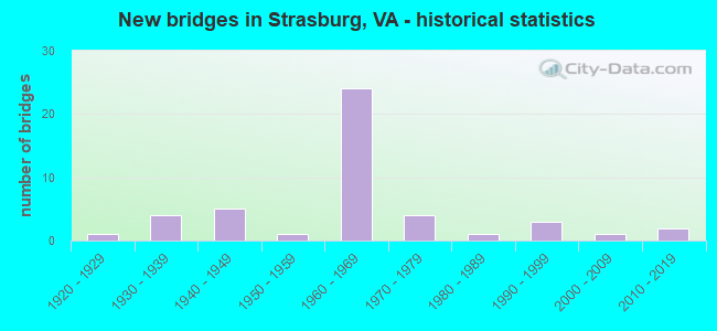
- New bridges - historical statistics
- 11920-1929
- 41930-1939
- 51940-1949
- 11950-1959
- 241960-1969
- 41970-1979
- 11980-1989
- 31990-1999
- 12000-2009
- 22010-2019

- Reconstructed bridges - Historical Statistics
- 11980-1989
- 01990-1999
- 22000-2009


- Bridge Condition - Deck
- 18.2%Very good
- 39.4%Good
- 21.2%Satisfactory
- 21.2%Fair

- Bridge Condition - Superstructure
- 21.2%Very good
- 24.2%Good
- 36.4%Satisfactory
- 18.2%Fair

- Bridge Condition - Substructure
- 18.2%Very good
- 24.2%Good
- 39.4%Satisfactory
- 18.2%Fair

- Bridge Condition - Channel
- 56.5%Very good
- 30.4%Good
- 8.7%Satisfactory
- 4.3%Fair

- Bridge Condition - Culverts
- 20.0%Very good
- 40.0%Good
- 20.0%Satisfactory
- 20.0%Fair
Find on map >> Show street view
Structure Number: 526, Location: 1.82 FR 631/2.64 TO 250 E (Lat: 38.010692, Lng: -78.477483), Route carried "on" structure: Interstate 64, Year Built: 1969, Status: Open, Structure Length: 10.49m (34.42ft), Average Daily Traffic: 18,290 (year 2020), Truck Traffic: 11%, Average Future Daily Traffic: 25,606 (year 2040), Design Load: HS 20+Mod, Features Intersected: RTE 20 (SCOTTSVILLE RD)
Minimum Vertical Clearance: 30+ m (98+ ft), Kilometerpoint: 196.041, Lanes on structure: 3, Lanes under structure: 5, Base Highway Network: Yes, Owner: State Highway Agency, Approaching Roadway Width: 11.3m (37.1ft), Skew: 4 degrees, Material/Design: Steel, Design/Construction: Stringer/Multi-beam, Number Of Spans In Main Unit: 4, Length of Maximum Span: 33.2m (108.9ft), Curb or Sidewalk Widths: Left: 0.2m (0.7ft), Right: 0.2m (0.7ft), Curb-To-Curb Width: 13.5m (44.3ft), Out-to-Out Width: 14.6m (47.9ft)
Condition: Deck: Good, Superstructure: Satisfactory, Substructure: Fair, Operating Rating: 77.1 metric tons, Method Used To Determine Operating Rating: Load and Resistance Factor (LRFR), Inventory Rating: 59.9 metric tons, Method Used To Determine Inventory Rating: Load and Resistance Factor (LRFR), Structural Evaluation: Somewhat better than minimum adequacy, Deck Geometry: Meets minimum limits, Underclear: Equal to present minimum criteria, Approach Roadway Alignment: Equal to present desirable criteria, Designated Inspection Frequency: Every 24 months, Inspection Date: August 2021, Deck Structure Type: Concrete Cast-file-Place, Wearing Surface/Protective System: Wearing Surface: Latex Concrete
Find on map >> Show street view
Structure Number: 501, Location: .15 Fr 628 & 0.16 To 1121 (Lat: 37.239267, Lng: -77.430933), Route carried "on" structure: State highway 36, Year Built: 1990, Status: Open, Structure Length: 5.00m (16.40ft), Average Daily Traffic: 5,327 (year 2020), Truck Traffic: 1%, Average Future Daily Traffic: 5,860 (year 2040), Design Load: HS 20+Mod, Features Intersected: CSX TRANSPORTATION, Facility Carried by Structure: CHESTERFIELD AVE.
Minimum Vertical Clearance: 30+ m (98+ ft), Kilometerpoint: 7.868, Lanes on structure: 4, Owner: State Highway Agency, Approaching Roadway Width: 16.5m (54.1ft), Skew: 22 degrees, Material/Design: Steel continuous, Design/Construction: Stringer/Multi-beam, Number Of Spans In Main Unit: 3, Length of Maximum Span: 22.6m (74.1ft), Curb or Sidewalk Widths: Left: 1.8m (5.9ft), Right: 1.8m (5.9ft), Curb-To-Curb Width: 16.5m (54.1ft), Out-to-Out Width: 25.6m (84.0ft)
Condition: Deck: Good, Superstructure: Good, Substructure: Good, Operating Rating: 49.9 metric tons, Method Used To Determine Operating Rating: Load and Resistance Factor (LRFR), Inventory Rating: 36.3 metric tons, Method Used To Determine Inventory Rating: Load and Resistance Factor (LRFR), Structural Evaluation: Better than present minimum criteria, Deck Geometry: Meets minimum limits, Underclear: Better than present minimum criteria, Approach Roadway Alignment: Equal to present desirable criteria, Designated Inspection Frequency: Every 24 months, Inspection Date: April 2020, Deck Structure Type: Concrete Cast-file-Place, Wearing Surface/Protective System: Deck Protection: Epoxy Coated Reinforcing
Find on map >> Show street view
Structure Number: 502, Location: 0.32 Fr 755 & 0.85 To 678 (Lat: 37.495653, Lng: -77.561686), Route carried "on" structure: US 60, Year Built: 1988, Status: Open, Structure Length: 8.96m (29.40ft), Average Daily Traffic: 25,978 (year 2020), Truck Traffic: 1%, Average Future Daily Traffic: 36,369 (year 2040), Design Load: HS 20+Mod, Features Intersected: WB RTE 76 (POWHITE PKWY), Facility Carried by Structure: MIDLOTHIAN TRNPIKE
Minimum Vertical Clearance: 30+ m (98+ ft), Kilometerpoint: 293.345, Lanes on structure: 4, Lanes under structure: 8, Base Highway Network: Yes, Owner: State Highway Agency, Approaching Roadway Width: 19.8m (65.0ft), Skew: 2 degrees, Material/Design: Steel continuous, Design/Construction: Stringer/Multi-beam, Number Of Spans In Main Unit: 3, Length of Maximum Span: 34.1m (111.9ft), Curb-To-Curb Width: 19.1m (62.7ft), Out-to-Out Width: 20.1m (65.9ft)
Condition: Deck: Good, Superstructure: Good, Substructure: Satisfactory, Operating Rating: 73.5 metric tons, Method Used To Determine Operating Rating: Load and Resistance Factor (LRFR), Inventory Rating: 56.2 metric tons, Method Used To Determine Inventory Rating: Load and Resistance Factor (LRFR), Structural Evaluation: Equal to present minimum criteria, Deck Geometry: Equal to present minimum criteria, Underclear: Meets minimum limits, Approach Roadway Alignment: Equal to present desirable criteria, Designated Inspection Frequency: Every 24 months, Inspection Date: June 2020, Deck Structure Type: Concrete Cast-file-Place, Wearing Surface/Protective System: Deck Protection: Epoxy Coated Reinforcing
Find on map >> Show street view
Structure Number: 525, Location: 0.19 Fr 1 & 0.13 To 680 (Lat: 37.342692, Lng: -77.406156), Route carried "on" structure: County highway 618, Year Built: 1977, Status: Open, Structure Length: 5.61m (18.41ft), Average Daily Traffic: 3,812 (year 2020), Truck Traffic: 3%, Average Future Daily Traffic: 5,337 (year 2040), Design Load: HS 20+Mod, Features Intersected: INTERSTATE -95, Facility Carried by Structure: OLD BERM HUND RD
Minimum Vertical Clearance: 30+ m (98+ ft), Kilometerpoint: 0.306, Lanes on structure: 2, Lanes under structure: 6, Owner: State Highway Agency, Approaching Roadway Width: 12.2m (40.0ft), Material/Design: Steel continuous, Design/Construction: Stringer/Multi-beam, Number Of Spans In Main Unit: 2, Length of Maximum Span: 28.0m (91.9ft), Curb-To-Curb Width: 10.4m (34.1ft), Out-to-Out Width: 11.6m (38.1ft)
Condition: Deck: Good, Superstructure: Satisfactory, Substructure: Satisfactory, Operating Rating: 52.6 metric tons, Method Used To Determine Operating Rating: Load and Resistance Factor (LRFR), Inventory Rating: 40.8 metric tons, Method Used To Determine Inventory Rating: Load and Resistance Factor (LRFR), Structural Evaluation: Equal to present minimum criteria, Deck Geometry: Somewhat better than minimum adequacy, Underclear: High priority of corrective action, Approach Roadway Alignment: Equal to present desirable criteria, Designated Inspection Frequency: Every 24 months, Inspection Date: October 2020, Deck Structure Type: Concrete Cast-file-Place, Wearing Surface/Protective System: Wearing Surface: Latex Concrete
Find on map >> Show street view
Structure Number: 12754, Location: 3.48NHMPTN CO1540NCL VA B (Lat: 37.082478, Lng: -76.009156), Route carried "on" structure: US 13, Year Built: 1964, Status: Open, Structure Length: 41.18m (135.10ft), Average Daily Traffic: 4,629 (year 2020), Truck Traffic: 8%, Average Future Daily Traffic: 6,481 (year 2040), Design Load: HS 20+Mod, Features Intersected: CHES. BAY - TRESTLE D
Minimum Vertical Clearance: 30+ m (98+ ft), Kilometerpoint: 55.173, Lanes on structure: 2, Base Highway Network: Yes, Toll: On toll road, Owner: State Toll Authority, Approaching Roadway Width: 9.4m (30.8ft), Material/Design: Concrete, Design/Construction: Tee Beam, Number Of Spans In Main Unit: 18, Length of Maximum Span: 22.9m (75.1ft), Curb or Sidewalk Widths: Left: 0.5m (1.6ft), Right: 0.5m (1.6ft), Curb-To-Curb Width: 8.5m (27.9ft), Out-to-Out Width: 10.0m (32.8ft)
Condition: Deck: Good, Superstructure: Good, Substructure: Good, Channel: Very good, Operating Rating: 50.8 metric tons, Method Used To Determine Operating Rating: Load and Resistance Factor (LRFR), Inventory Rating: 39.0 metric tons, Method Used To Determine Inventory Rating: Load and Resistance Factor (LRFR), Structural Evaluation: Better than present minimum criteria, Deck Geometry: High priority of corrective action, Waterway Adequacy: Equal to present minimum criteria, Approach Roadway Alignment: Equal to present desirable criteria, Length Of Structure Improvement: 41.18m (135.10ft), Designated Inspection Frequency: Every 24 months, Underwater Inspection Frequency: Every 60 months, Inspection Date: September 2020, Underwater Inspection Date: August 2021, Bridge Improvement Cost: $2,702,000, Roadway Improvement Cost: $10,000, Total Project Cost: $2,713,000 ( Estimate for 2018), Deck Structure Type: Other, Wearing Surface/Protective System: Wearing Surface: Bituminous
Find on map >> Show street view
Structure Number: 13213, Location: 0.70 RT 710; 0.60 RT 668 (Lat: 36.820389, Lng: -80.245281), Route carried "on" structure: State highway 40, Year Built: 1949, Status: Open, Structure Length: 1.31m (4.30ft), Average Daily Traffic: 251 (year 2020), Truck Traffic: 12%, Average Future Daily Traffic: 276 (year 2040), Design Load: HS 20+Mod, Features Intersected: Big Widgeon Creek
Minimum Vertical Clearance: 30+ m (98+ ft), Kilometerpoint: 5.876, Lanes on structure: 2, Owner: State Highway Agency, Approaching Roadway Width: 5.5m (18.0ft), Material/Design: Concrete, Design/Construction: Box Beam or Girders - Multiple, Number Of Spans In Main Unit: 1, Length of Maximum Span: 13.1m (43.0ft), Curb or Sidewalk Widths: Left: 0.2m (0.7ft), Right: 0.2m (0.7ft), Curb-To-Curb Width: 6.1m (20.0ft), Out-to-Out Width: 6.4m (21.0ft)
Condition: Deck: Good, Superstructure: Good, Substructure: Good, Channel: Satisfactory, Operating Rating: 82.6 metric tons, Method Used To Determine Operating Rating: Load and Resistance Factor (LRFR), Inventory Rating: 63.5 metric tons, Method Used To Determine Inventory Rating: Load and Resistance Factor (LRFR), Structural Evaluation: Better than present minimum criteria, Deck Geometry: Meets minimum limits, Waterway Adequacy: Better than present minimum criteria, Approach Roadway Alignment: Equal to present desirable criteria, Designated Inspection Frequency: Every 24 months, Inspection Date: November 2021, Deck Structure Type: Concrete Cast-file-Place, Wearing Surface/Protective System: Wearing Surface: Bituminous
Find on map >> Show street view
Structure Number: 13895, Location: 2.10 to 617 - 0.62 to 460 (Lat: 37.273408, Lng: -78.273461), Route carried "on" structure: State highway 307, Year Built: 1940, Status: Open, Structure Length: 0.73m (2.40ft), Average Daily Traffic: 5,039 (year 2020), Truck Traffic: 7%, Average Future Daily Traffic: 7,055 (year 2040), Features Intersected: Saylers Creek, Facility Carried by Structure: Holly Farms Road
Minimum Vertical Clearance: 30+ m (98+ ft), Kilometerpoint: 1.056, Lanes on structure: 2, Base Highway Network: Yes, Owner: State Highway Agency, Approaching Roadway Width: 7.9m (25.9ft), Material/Design: Concrete, Design/Construction: Culvert, Number Of Spans In Main Unit: 3, Length of Maximum Span: 2.4m (7.9ft)
Condition: Channel: Fair, Culverts: Fair, Operating Rating: 89.8 metric tons, Method Used To Determine Operating Rating: Load Factor (LF), Inventory Rating: 89.8 metric tons, Method Used To Determine Inventory Rating: Load Factor (LF), Structural Evaluation: Somewhat better than minimum adequacy, Waterway Adequacy: Better than present minimum criteria, Approach Roadway Alignment: Equal to present desirable criteria, Designated Inspection Frequency: Every 24 months, Inspection Date: Febuary 2021
Find on map >> Show street view
Structure Number: 16949, Location: 0.06 TO 55 - 0.11 TO 648 (Lat: 38.988806, Lng: -78.360122), Route carried "on" structure: US 11, Year Built: 1935, Status: Open, Structure Length: 0.85m (2.79ft), Average Daily Traffic: 6,085 (year 2020), Truck Traffic: 2%, Average Future Daily Traffic: 6,694 (year 2040), Design Load: H 15, Features Intersected: TOWN RUN @ STRASBURG, Facility Carried by Structure: OLD VALLEY PIKE
Minimum Vertical Clearance: 30+ m (98+ ft), Kilometerpoint: 501.276, Lanes on structure: 2, Owner: State Highway Agency, Approaching Roadway Width: 11.9m (39.0ft), Material/Design: Concrete, Design/Construction: Slab, Number Of Spans In Main Unit: 2, Length of Maximum Span: 4.3m (14.1ft), Curb or Sidewalk Widths: Left: 2.1m (6.9ft), Right: 2.1m (6.9ft), Curb-To-Curb Width: 11.9m (39.0ft), Out-to-Out Width: 16.8m (55.1ft)
Condition: Deck: Fair, Superstructure: Fair, Substructure: Satisfactory, Channel: Very good, Operating Rating: 29.9 metric tons, Method Used To Determine Operating Rating: Load and Resistance Factor (LRFR), Inventory Rating: 22.7 metric tons, Method Used To Determine Inventory Rating: Load and Resistance Factor (LRFR), Structural Evaluation: Somewhat better than minimum adequacy, Deck Geometry: Somewhat better than minimum adequacy, Waterway Adequacy: Equal to present minimum criteria, Approach Roadway Alignment: Equal to present desirable criteria, Length Of Structure Improvement: 0.91m (2.99ft), Designated Inspection Frequency: Every 24 months, Inspection Date: April 2021, Bridge Improvement Cost: $84,000, Roadway Improvement Cost: $10,000, Total Project Cost: $95,000, Deck Structure Type: Concrete Cast-file-Place, Wearing Surface/Protective System: Wearing Surface: Latex Concrete
Find on map >> Show street view
Structure Number: 16964, Location: 0.01 TO 601S-0.03 TO 601N (Lat: 38.979033, Lng: -78.388103), Route carried "on" structure: US 11, Year Built: 1955, Status: Open, Structure Length: 2.35m (7.71ft), Average Daily Traffic: 2,481 (year 2020), Truck Traffic: 2%, Average Future Daily Traffic: 3,475 (year 2040), Design Load: HS 20+Mod, Features Intersected: TUMBLING RUN, Facility Carried by Structure: OLD VALLEY PK -NBL
Minimum Vertical Clearance: 30+ m (98+ ft), Kilometerpoint: 498.204, Lanes on structure: 2, Owner: State Highway Agency, Approaching Roadway Width: 7.9m (25.9ft), Material/Design: Concrete, Design/Construction: Tee Beam, Number Of Spans In Main Unit: 2, Length of Maximum Span: 11.9m (39.0ft), Curb-To-Curb Width: 12.2m (40.0ft), Out-to-Out Width: 12.8m (42.0ft)
Condition: Deck: Fair, Superstructure: Fair, Substructure: Satisfactory, Channel: Very good, Operating Rating: 48.1 metric tons, Method Used To Determine Operating Rating: Load and Resistance Factor (LRFR), Inventory Rating: 37.2 metric tons, Method Used To Determine Inventory Rating: Load and Resistance Factor (LRFR), Structural Evaluation: Somewhat better than minimum adequacy, Deck Geometry: Better than present minimum criteria, Waterway Adequacy: Equal to present minimum criteria, Approach Roadway Alignment: Equal to present minimum criteria, Designated Inspection Frequency: Every 24 months, Inspection Date: July 2020, Deck Structure Type: Concrete Cast-file-Place, Wearing Surface/Protective System: Wearing Surface: Latex Concrete
Find on map >> Show street view
Structure Number: 16966, Location: 0.20 TO 629 -0.20 TO F245 (Lat: 39.007764, Lng: -78.334661), Route carried "on" structure: US 11, Year Built: 1965, Status: Open, Structure Length: 8.95m (29.36ft), Average Daily Traffic: 1,843 (year 2020), Truck Traffic: 6%, Average Future Daily Traffic: 2,580 (year 2040), Design Load: HS 20+Mod, Features Intersected: I-81
Minimum Vertical Clearance: 30+ m (98+ ft), Kilometerpoint: 504.430, Lanes on structure: 2, Lanes under structure: 4, Owner: State Highway Agency, Approaching Roadway Width: 9.1m (29.9ft), Skew: 2 degrees, Material/Design: Prestressed concrete, Design/Construction: Stringer/Multi-beam, Number Of Spans In Main Unit: 5, Length of Maximum Span: 19.1m (62.7ft), Curb or Sidewalk Widths: Left: 0.5m (1.6ft), Right: 0.5m (1.6ft), Curb-To-Curb Width: 9.1m (29.9ft), Out-to-Out Width: 10.7m (35.1ft)
Condition: Deck: Satisfactory, Superstructure: Fair, Substructure: Fair, Operating Rating: 81.6 metric tons, Method Used To Determine Operating Rating: Load and Resistance Factor (LRFR), Inventory Rating: 53.5 metric tons, Method Used To Determine Inventory Rating: Load and Resistance Factor (LRFR), Structural Evaluation: Somewhat better than minimum adequacy, Deck Geometry: Meets minimum limits, Underclear: Somewhat better than minimum adequacy, Approach Roadway Alignment: Better than present minimum criteria, Designated Inspection Frequency: Every 24 months, Inspection Date: Febuary 2021, Bridge Improvement Cost: $235,000, Roadway Improvement Cost: $1,000, Total Project Cost: $237,000, Deck Structure Type: Concrete Cast-file-Place, Wearing Surface/Protective System: Wearing Surface: Bituminous, Membrane: Preformed Fabric
Find on map >> Show street view
Structure Number: 16968, Location: 0.20 TO 629 - 0.20 TOF245 (Lat: 39.007675, Lng: -78.334425), Route carried "on" structure: US 11, Year Built: 1965, Status: Open, Structure Length: 8.95m (29.36ft), Average Daily Traffic: 1,843 (year 2020), Truck Traffic: 6%, Average Future Daily Traffic: 2,580 (year 2040), Design Load: HS 20+Mod, Features Intersected: I-81, Facility Carried by Structure: OLD VALLEY PK -NBL
Minimum Vertical Clearance: 30+ m (98+ ft), Kilometerpoint: 504.430, Lanes on structure: 2, Lanes under structure: 4, Owner: State Highway Agency, Approaching Roadway Width: 9.1m (29.9ft), Skew: 2 degrees, Material/Design: Prestressed concrete, Design/Construction: Stringer/Multi-beam, Number Of Spans In Main Unit: 5, Length of Maximum Span: 19.1m (62.7ft), Curb or Sidewalk Widths: Left: 0.5m (1.6ft), Right: 0.5m (1.6ft), Curb-To-Curb Width: 9.1m (29.9ft), Out-to-Out Width: 10.7m (35.1ft)
Condition: Deck: Good, Superstructure: Fair, Substructure: Fair, Operating Rating: 81.6 metric tons, Method Used To Determine Operating Rating: Load and Resistance Factor (LRFR), Inventory Rating: 52.6 metric tons, Method Used To Determine Inventory Rating: Load and Resistance Factor (LRFR), Structural Evaluation: Somewhat better than minimum adequacy, Deck Geometry: Meets minimum limits, Underclear: Meets minimum limits, Approach Roadway Alignment: Equal to present desirable criteria, Designated Inspection Frequency: Every 24 months, Inspection Date: Febuary 2021, Bridge Improvement Cost: $219,000, Roadway Improvement Cost: $1,000, Total Project Cost: $221,000, Deck Structure Type: Concrete Cast-file-Place, Wearing Surface/Protective System: Wearing Surface: Bituminous, Membrane: Preformed Fabric
Find on map >> Show street view
Structure Number: 16987, Location: 0.01 TO 623E-0.01 TO 623W (Lat: 39.037114, Lng: -78.383261), Route carried "on" structure: State highway 55, Year Built: 1949, Status: Open, Structure Length: 1.37m (4.49ft), Average Daily Traffic: 7,306 (year 2020), Truck Traffic: 6%, Average Future Daily Traffic: 10,160 (year 2040), Design Load: HS 20, Features Intersected: MULBERRY RUN, Facility Carried by Structure: JOHN MARSHALL HWY
Minimum Vertical Clearance: 30+ m (98+ ft), Kilometerpoint: 19.150, Lanes on structure: 2, Base Highway Network: Yes, Owner: State Highway Agency, Approaching Roadway Width: 6.7m (22.0ft), Material/Design: Concrete, Design/Construction: Slab, Number Of Spans In Main Unit: 2, Length of Maximum Span: 7.0m (23.0ft), Curb or Sidewalk Widths: Left: 0.5m (1.6ft), Right: 0.5m (1.6ft), Curb-To-Curb Width: 7.9m (25.9ft), Out-to-Out Width: 8.5m (27.9ft)
Condition: Deck: Satisfactory, Superstructure: Satisfactory, Substructure: Satisfactory, Channel: Very good, Operating Rating: 38.1 metric tons, Method Used To Determine Operating Rating: Load Factor (LF), Inventory Rating: 22.7 metric tons, Method Used To Determine Inventory Rating: Load Factor (LF), Structural Evaluation: Somewhat better than minimum adequacy, Deck Geometry: High priority of replacement, Waterway Adequacy: Equal to present minimum criteria, Approach Roadway Alignment: Equal to present minimum criteria, Length Of Structure Improvement: 1.37m (4.49ft), Designated Inspection Frequency: Every 24 months, Inspection Date: June 2020, Bridge Improvement Cost: $48,000, Roadway Improvement Cost: $5,000, Total Project Cost: $54,000, Deck Structure Type: Concrete Cast-file-Place
Find on map >> Show street view
Structure Number: 16988, Location: 0.25 TO 632 - 0.10 TO 741 (Lat: 39.043697, Lng: -78.378778), Route carried "on" structure: State highway 55, Year Built: 1947, Status: Open, Structure Length: 1.01m (3.31ft), Average Daily Traffic: 7,306 (year 2020), Truck Traffic: 6%, Average Future Daily Traffic: 10,160 (year 2040), Design Load: H 20, Features Intersected: PAGE CREEK, Facility Carried by Structure: JOHN MARSHALL HWY
Minimum Vertical Clearance: 30+ m (98+ ft), Kilometerpoint: 18.301, Lanes on structure: 2, Base Highway Network: Yes, Owner: State Highway Agency, Approaching Roadway Width: 6.4m (21.0ft), Material/Design: Concrete, Design/Construction: Tee Beam, Number Of Spans In Main Unit: 1, Length of Maximum Span: 9.4m (30.8ft), Curb or Sidewalk Widths: Left: 0.5m (1.6ft), Right: 0.5m (1.6ft), Curb-To-Curb Width: 7.3m (24.0ft), Out-to-Out Width: 7.8m (25.6ft)
Condition: Deck: Fair, Superstructure: Very good, Substructure: Very good, Channel: Very good, Operating Rating: 49.0 metric tons, Method Used To Determine Operating Rating: Load Factor (LF), Inventory Rating: 29.0 metric tons, Method Used To Determine Inventory Rating: Load Factor (LF), Structural Evaluation: Better than present minimum criteria, Deck Geometry: High priority of replacement, Waterway Adequacy: Equal to present minimum criteria, Approach Roadway Alignment: Equal to present desirable criteria, Length Of Structure Improvement: 1.01m (3.31ft), Designated Inspection Frequency: Every 24 months, Inspection Date: July 2020, Bridge Improvement Cost: $50,000, Roadway Improvement Cost: $10,000, Total Project Cost: $61,000, Deck Structure Type: Concrete Cast-file-Place, Wearing Surface/Protective System: Wearing Surface: Bituminous, Membrane: Epoxy
Find on map >> Show street view
Structure Number: 16991, Location: 0.12 TO 623 - 0.50 TO 632 (Lat: 39.035283, Lng: -78.382325), Route carried "on" structure: State highway 55, Year Built: 1947, Status: Open, Structure Length: 0.76m (2.49ft), Average Daily Traffic: 7,306 (year 2020), Truck Traffic: 6%, Average Future Daily Traffic: 10,160 (year 2040), Design Load: H 15, Features Intersected: TRIB CEDAR CREEK, Facility Carried by Structure: JOHN MARSHALL HWY
Minimum Vertical Clearance: 30+ m (98+ ft), Kilometerpoint: 19.382, Lanes on structure: 2, Base Highway Network: Yes, Owner: State Highway Agency, Approaching Roadway Width: 7.3m (24.0ft), Skew: 1 degrees, Material/Design: Concrete, Design/Construction: Arch - Deck, Number Of Spans In Main Unit: 2, Length of Maximum Span: 3.0m (9.8ft), Curb-To-Curb Width: 9.8m (32.2ft), Out-to-Out Width: 16.8m (55.1ft)
Condition: Deck: Satisfactory, Superstructure: Satisfactory, Substructure: Very good, Channel: Satisfactory, Operating Rating: 22.7 metric tons, Method Used To Determine Operating Rating: Load and Resistance Factor (LRFR), Inventory Rating: 17.2 metric tons, Method Used To Determine Inventory Rating: Load and Resistance Factor (LRFR), Structural Evaluation: Meets minimum limits, Deck Geometry: Meets minimum limits, Waterway Adequacy: Equal to present minimum criteria, Approach Roadway Alignment: Equal to present minimum criteria, Designated Inspection Frequency: Every 24 months, Inspection Date: June 2020, Deck Structure Type: Concrete Cast-file-Place, Wearing Surface/Protective System: Wearing Surface: Bituminous
Find on map >> Show street view
Structure Number: 16992, Location: 0.40 TO 637 - 0.12 TO 633 (Lat: 39.012442, Lng: -78.363433), Route carried "on" structure: State highway 55, Year Built: 1965, Status: Open, Structure Length: 11.98m (39.30ft), Average Daily Traffic: 4,823 (year 2020), Truck Traffic: 4%, Average Future Daily Traffic: 4,831 (year 2040), Design Load: HS 20+Mod, Features Intersected: I-81, Facility Carried by Structure: WARDENSVILLE PIKE
Minimum Vertical Clearance: 30+ m (98+ ft), Kilometerpoint: 23.192, Lanes on structure: 2, Lanes under structure: 4, Base Highway Network: Yes, Owner: State Highway Agency, Approaching Roadway Width: 11.0m (36.1ft), Skew: 5 degrees, Material/Design: Steel, Design/Construction: Stringer/Multi-beam, Number Of Spans In Main Unit: 5, Length of Maximum Span: 30.2m (99.1ft), Curb or Sidewalk Widths: Left: 0.5m (1.6ft), Right: 0.5m (1.6ft), Curb-To-Curb Width: 9.1m (29.9ft), Out-to-Out Width: 10.7m (35.1ft)
Condition: Deck: Fair, Superstructure: Satisfactory, Substructure: Fair, Operating Rating: 69.9 metric tons, Method Used To Determine Operating Rating: Load and Resistance Factor (LRFR), Inventory Rating: 53.5 metric tons, Method Used To Determine Inventory Rating: Load and Resistance Factor (LRFR), Structural Evaluation: Somewhat better than minimum adequacy, Deck Geometry: Meets minimum limits, Underclear: Somewhat better than minimum adequacy, Approach Roadway Alignment: Better than present minimum criteria, Length Of Structure Improvement: 11.98m (39.30ft), Designated Inspection Frequency: Every 24 months, Inspection Date: May 2021, Bridge Improvement Cost: $100,000, Roadway Improvement Cost: $20,000, Total Project Cost: $121,000, Deck Structure Type: Concrete Cast-file-Place, Wearing Surface/Protective System: Wearing Surface: Epoxy Overlay
Find on map >> Show street view
Structure Number: 17007, Location: 2.07 TO 651 - 3.07 TO 55 (Lat: 38.988147, Lng: -78.412767), Route carried "on" structure: Interstate 81, Year Built: 1965, Status: Open, Structure Length: 3.31m (10.86ft), Average Daily Traffic: 22,021 (year 2020), Truck Traffic: 24%, Average Future Daily Traffic: 30,829 (year 2040), Design Load: HS 20+Mod, Features Intersected: BATTLEFIELD RD (RT 601)
Minimum Vertical Clearance: 30+ m (98+ ft), Kilometerpoint: 473.336, Lanes on structure: 2, Lanes under structure: 2, Base Highway Network: Yes, Owner: State Highway Agency, Approaching Roadway Width: 11.3m (37.1ft), Material/Design: Prestressed concrete, Design/Construction: Box Beam or Girders - Single/Spread, Number Of Spans In Main Unit: 3, Length of Maximum Span: 12.2m (40.0ft), Curb-To-Curb Width: 12.8m (42.0ft), Out-to-Out Width: 13.4m (44.0ft)
Condition: Deck: Good, Superstructure: Good, Substructure: Satisfactory, Operating Rating: 89.8 metric tons, Method Used To Determine Operating Rating: Load and Resistance Factor (LRFR), Inventory Rating: 70.8 metric tons, Method Used To Determine Inventory Rating: Load and Resistance Factor (LRFR), Structural Evaluation: Equal to present minimum criteria, Deck Geometry: Equal to present desirable criteria, Underclear: Meets minimum limits, Approach Roadway Alignment: Better than present minimum criteria, Designated Inspection Frequency: Every 24 months, Inspection Date: March 2021, Bridge Improvement Cost: $40,000, Roadway Improvement Cost: $4,000, Total Project Cost: $45,000, Deck Structure Type: Concrete Cast-file-Place, Wearing Surface/Protective System: Wearing Surface: Latex Concrete
Find on map >> Show street view
Structure Number: 17009, Location: 2.07 TO 651 - 3.07 TO 55 (Lat: 38.988675, Lng: -78.413486), Route carried "on" structure: Interstate 81, Year Built: 1965, Status: Open, Structure Length: 3.23m (10.60ft), Average Daily Traffic: 21,078 (year 2020), Truck Traffic: 24%, Average Future Daily Traffic: 29,509 (year 2040), Design Load: HS 20+Mod, Features Intersected: BATTLEFIELD RD
Minimum Vertical Clearance: 30+ m (98+ ft), Kilometerpoint: 473.770, Lanes on structure: 2, Lanes under structure: 2, Base Highway Network: Yes, Owner: State Highway Agency, Approaching Roadway Width: 11.3m (37.1ft), Material/Design: Prestressed concrete, Design/Construction: Box Beam or Girders - Single/Spread, Number Of Spans In Main Unit: 3, Length of Maximum Span: 12.2m (40.0ft), Curb-To-Curb Width: 12.8m (42.0ft), Out-to-Out Width: 13.4m (44.0ft)
Condition: Deck: Fair, Superstructure: Satisfactory, Substructure: Satisfactory, Operating Rating: 91.6 metric tons, Method Used To Determine Operating Rating: Load and Resistance Factor (LRFR), Inventory Rating: 70.8 metric tons, Method Used To Determine Inventory Rating: Load and Resistance Factor (LRFR), Structural Evaluation: Equal to present minimum criteria, Deck Geometry: Equal to present desirable criteria, Underclear: Meets minimum limits, Approach Roadway Alignment: Better than present minimum criteria, Designated Inspection Frequency: Every 24 months, Inspection Date: Febuary 2021, Bridge Improvement Cost: $10,000, Roadway Improvement Cost: $2,000, Total Project Cost: $12,000, Deck Structure Type: Concrete Cast-file-Place, Wearing Surface/Protective System: Wearing Surface: Latex Concrete
Find on map >> Show street view
Structure Number: 17011, Location: 0.94 TO 55 - 0.83 TO 11 (Lat: 39.013533, Lng: -78.348758), Route carried "on" structure: Interstate 81, Year Built: 1965, Status: Open, Structure Length: 6.58m (21.59ft), Average Daily Traffic: 24,017 (year 2020), Truck Traffic: 24%, Average Future Daily Traffic: 33,624 (year 2040), Design Load: HS 20+Mod, Features Intersected: CSX RAILROAD
Minimum Vertical Clearance: 30+ m (98+ ft), Kilometerpoint: 479.788, Lanes on structure: 2, Base Highway Network: Yes, Owner: State Highway Agency, Approaching Roadway Width: 11.3m (37.1ft), Skew: 4 degrees, Material/Design: Prestressed concrete, Design/Construction: Stringer/Multi-beam, Number Of Spans In Main Unit: 3, Length of Maximum Span: 21.9m (71.9ft), Curb-To-Curb Width: 12.8m (42.0ft), Out-to-Out Width: 13.4m (44.0ft)
Condition: Deck: Satisfactory, Superstructure: Satisfactory, Substructure: Satisfactory, Operating Rating: 89.8 metric tons, Method Used To Determine Operating Rating: Load and Resistance Factor (LRFR), Inventory Rating: 59.9 metric tons, Method Used To Determine Inventory Rating: Load and Resistance Factor (LRFR), Structural Evaluation: Equal to present minimum criteria, Deck Geometry: Equal to present desirable criteria, Underclear: Equal to present minimum criteria, Approach Roadway Alignment: Better than present minimum criteria, Designated Inspection Frequency: Every 24 months, Inspection Date: May 2020, Bridge Improvement Cost: $300,000, Roadway Improvement Cost: $50,000, Total Project Cost: $351,000, Deck Structure Type: Concrete Cast-file-Place, Wearing Surface/Protective System: Wearing Surface: Latex Concrete
Find on map >> Show street view
Structure Number: 17012, Location: 0.94 TO 55 - 0.83 TO 11 (Lat: 39.013650, Lng: -78.348333), Route carried "on" structure: Interstate 81, Year Built: 1965, Status: Open, Structure Length: 6.58m (21.59ft), Average Daily Traffic: 22,760 (year 2020), Truck Traffic: 24%, Average Future Daily Traffic: 31,864 (year 2040), Design Load: HS 20+Mod, Features Intersected: CSX RAILROAD
Minimum Vertical Clearance: 30+ m (98+ ft), Kilometerpoint: 480.254, Lanes on structure: 2, Base Highway Network: Yes, Owner: State Highway Agency, Approaching Roadway Width: 11.3m (37.1ft), Skew: 4 degrees, Material/Design: Prestressed concrete, Design/Construction: Stringer/Multi-beam, Number Of Spans In Main Unit: 3, Length of Maximum Span: 21.9m (71.9ft), Curb-To-Curb Width: 12.8m (42.0ft), Out-to-Out Width: 13.4m (44.0ft)
Condition: Deck: Fair, Superstructure: Satisfactory, Substructure: Satisfactory, Operating Rating: 89.8 metric tons, Method Used To Determine Operating Rating: Load and Resistance Factor (LRFR), Inventory Rating: 59.9 metric tons, Method Used To Determine Inventory Rating: Load and Resistance Factor (LRFR), Structural Evaluation: Equal to present minimum criteria, Deck Geometry: Equal to present desirable criteria, Underclear: Equal to present minimum criteria, Approach Roadway Alignment: Equal to present desirable criteria, Designated Inspection Frequency: Every 24 months, Inspection Date: May 2020, Bridge Improvement Cost: $300,000, Roadway Improvement Cost: $50,000, Total Project Cost: $351,000, Deck Structure Type: Concrete Cast-file-Place, Wearing Surface/Protective System: Wearing Surface: Latex Concrete
Find on map >> Show street view
Structure Number: 17063, Location: 2.05 TO 651 - 3.09 TO 55 (Lat: 38.988036, Lng: -78.412919), Route carried "on" structure: Interstate 81, Year Built: 1966, Status: Open, Structure Length: 0.79m (2.59ft), Average Daily Traffic: 22,021 (year 2020), Truck Traffic: 24%, Average Future Daily Traffic: 30,829 (year 2040), Design Load: HS 20, Features Intersected: SOUTH FORK CREEK
Minimum Vertical Clearance: 30+ m (98+ ft), Kilometerpoint: 473.303, Lanes on structure: 2, Base Highway Network: Yes, Owner: State Highway Agency, Approaching Roadway Width: 11.3m (37.1ft), Material/Design: Concrete, Design/Construction: Culvert, Number Of Spans In Main Unit: 3, Length of Maximum Span: 2.4m (7.9ft)
Condition: Channel: Good, Culverts: Good, Operating Rating: 89.8 metric tons, Method Used To Determine Operating Rating: Field evaluation and documented engineering judgment, Inventory Rating: 88.9 metric tons, Method Used To Determine Inventory Rating: Field evaluation and documented engineering judgment, Structural Evaluation: Better than present minimum criteria, Waterway Adequacy: Equal to present minimum criteria, Approach Roadway Alignment: Equal to present desirable criteria, Designated Inspection Frequency: Every 24 months, Inspection Date: April 2021
Find on map >> Show street view
Structure Number: 17064, Location: 2.05 TO 651 - 3.09 TO 55 (Lat: 38.988575, Lng: -78.413636), Route carried "on" structure: Interstate 81, Year Built: 1966, Status: Open, Structure Length: 0.79m (2.59ft), Average Daily Traffic: 21,078 (year 2020), Truck Traffic: 24%, Average Future Daily Traffic: 29,509 (year 2040), Design Load: HS 20, Features Intersected: SOUTH FORK CREEK
Minimum Vertical Clearance: 30+ m (98+ ft), Kilometerpoint: 473.738, Lanes on structure: 2, Base Highway Network: Yes, Owner: State Highway Agency, Approaching Roadway Width: 11.3m (37.1ft), Material/Design: Concrete, Design/Construction: Culvert, Number Of Spans In Main Unit: 3, Length of Maximum Span: 2.4m (7.9ft)
Condition: Channel: Good, Culverts: Satisfactory, Operating Rating: 89.8 metric tons, Method Used To Determine Operating Rating: Field evaluation and documented engineering judgment, Inventory Rating: 88.9 metric tons, Method Used To Determine Inventory Rating: Field evaluation and documented engineering judgment, Structural Evaluation: Equal to present minimum criteria, Waterway Adequacy: Equal to present minimum criteria, Approach Roadway Alignment: Equal to present desirable criteria, Designated Inspection Frequency: Every 24 months, Inspection Date: April 2021
Find on map >> Show street view
Structure Number: 17091, Location: 0.10 TO 696 - 0.15 TO 757 (Lat: 38.986894, Lng: -78.401375), Route carried "on" structure: County highway 601, Year Built: 1932, Year Reconstructed: 2011, Status: Open, Structure Length: 1.22m (4.00ft), Average Daily Traffic: 449 (year 2020), Average Future Daily Traffic: 455 (year 2040), Features Intersected: TUMBLING RUN@FISHER HILL, Facility Carried by Structure: BATTLEFIELD RD
Minimum Vertical Clearance: 30+ m (98+ ft), Kilometerpoint: 4.574, Lanes on structure: 2, Owner: State Highway Agency, Approaching Roadway Width: 6.1m (20.0ft), Material/Design: Prestressed concrete, Design/Construction: Slab, Number Of Spans In Main Unit: 2, Length of Maximum Span: 5.5m (18.0ft), Curb-To-Curb Width: 6.6m (21.7ft), Out-to-Out Width: 6.7m (22.0ft)
Condition: Deck: Very good, Superstructure: Very good, Substructure: Very good, Channel: Very good, Operating Rating: 70.8 metric tons, Method Used To Determine Operating Rating: Load and Resistance Factor (LRFR), Inventory Rating: 54.4 metric tons, Method Used To Determine Inventory Rating: Load and Resistance Factor (LRFR), Structural Evaluation: Equal to present desirable criteria, Deck Geometry: High priority of corrective action, Waterway Adequacy: Better than present minimum criteria, Approach Roadway Alignment: Equal to present minimum criteria, Designated Inspection Frequency: Every 24 months, Inspection Date: October 2021, Deck Structure Type: Other, Wearing Surface/Protective System: Wearing Surface: Bituminous, Membrane: Epoxy
Find on map >> Show street view
Structure Number: 17092, Location: 0.05 TO 757N -.01 TO 757S (Lat: 38.985225, Lng: -78.399114), Route carried "on" structure: County highway 601, Year Built: 1932, Status: Open, Structure Length: 2.32m (7.61ft), Average Daily Traffic: 701 (year 2020), Truck Traffic: 2%, Average Future Daily Traffic: 771 (year 2040), Features Intersected: TUMBLING RUN, Facility Carried by Structure: BATTLEFIELD RD
Minimum Vertical Clearance: 30+ m (98+ ft), Kilometerpoint: 4.885, Lanes on structure: 2, Owner: State Highway Agency, Approaching Roadway Width: 5.8m (19.0ft), Material/Design: Steel, Design/Construction: Culvert, Number Of Spans In Main Unit: 10, Length of Maximum Span: 0.9m (3.0ft)
Condition: Channel: Good, Culverts: Good, Operating Rating: 35.4 metric tons, Method Used To Determine Operating Rating: Field evaluation and documented engineering judgment, Inventory Rating: 20.9 metric tons, Method Used To Determine Inventory Rating: Field evaluation and documented engineering judgment, Structural Evaluation: Somewhat better than minimum adequacy, Waterway Adequacy: High priority of corrective action, Approach Roadway Alignment: Better than present minimum criteria, Designated Inspection Frequency: Every 24 months, Inspection Date: April 2021, Bridge Improvement Cost: $100,000, Roadway Improvement Cost: $25,000, Total Project Cost: $126,000
Find on map >> Show street view
Structure Number: 17097, Location: 0.30 TO 11 - 0.21 TO 821 (Lat: 38.981511, Lng: -78.393214), Route carried "on" structure: County highway 601, Year Built: 1964, Status: Open, Structure Length: 2.13m (6.99ft), Average Daily Traffic: 701 (year 2020), Truck Traffic: 2%, Average Future Daily Traffic: 771 (year 2040), Design Load: HS 20+Mod, Features Intersected: TUMBLING RUN, Facility Carried by Structure: BATTLEFIELD RD
Minimum Vertical Clearance: 30+ m (98+ ft), Kilometerpoint: 5.562, Lanes on structure: 2, Owner: State Highway Agency, Approaching Roadway Width: 5.8m (19.0ft), Material/Design: Steel, Design/Construction: Stringer/Multi-beam, Number Of Spans In Main Unit: 1, Length of Maximum Span: 20.4m (66.9ft), Curb or Sidewalk Widths: Left: 0.5m (1.6ft), Right: 0.5m (1.6ft), Curb-To-Curb Width: 7.3m (24.0ft), Out-to-Out Width: 8.8m (28.9ft)
Condition: Deck: Very good, Superstructure: Very good, Substructure: Good, Channel: Very good, Operating Rating: 62.6 metric tons, Method Used To Determine Operating Rating: Load and Resistance Factor (LRFR), Inventory Rating: 48.1 metric tons, Method Used To Determine Inventory Rating: Load and Resistance Factor (LRFR), Structural Evaluation: Better than present minimum criteria, Deck Geometry: Meets minimum limits, Waterway Adequacy: Equal to present desirable criteria, Approach Roadway Alignment: Better than present minimum criteria, Length Of Structure Improvement: 2.13m (6.99ft), Designated Inspection Frequency: Every 24 months, Inspection Date: April 2021, Bridge Improvement Cost: $44,000, Roadway Improvement Cost: $1,000, Total Project Cost: $48,000, Deck Structure Type: Concrete Cast-file-Place
Find on map >> Show street view
Structure Number: 17123, Location: 0.00 SHEN CO-0.00 FRED CO (Lat: 39.041053, Lng: -78.332239), Route carried "on" structure: County highway 622, Year Built: 1973, Status: Open, Structure Length: 5.33m (17.49ft), Average Daily Traffic: 278 (year 2017), Average Future Daily Traffic: 310 (year 2040), Design Load: HS 20+Mod, Features Intersected: CEDAR CREEK, Facility Carried by Structure: MINEBANK RD
Minimum Vertical Clearance: 30+ m (98+ ft), Kilometerpoint: 5.015, Lanes on structure: 2, Owner: State Highway Agency, Approaching Roadway Width: 6.1m (20.0ft), Skew: 2 degrees, Material/Design: Steel, Design/Construction: Stringer/Multi-beam, Number Of Spans In Main Unit: 3, Length of Maximum Span: 18.0m (59.1ft), Curb-To-Curb Width: 8.5m (27.9ft), Out-to-Out Width: 9.3m (30.5ft)
Condition: Deck: Good, Superstructure: Fair, Substructure: Fair, Channel: Very good, Operating Rating: 69.9 metric tons, Method Used To Determine Operating Rating: Load and Resistance Factor (LRFR), Inventory Rating: 53.9 metric tons, Method Used To Determine Inventory Rating: Load and Resistance Factor (LRFR), Structural Evaluation: Somewhat better than minimum adequacy, Deck Geometry: Equal to present minimum criteria, Waterway Adequacy: Better than present minimum criteria, Approach Roadway Alignment: Better than present minimum criteria, Designated Inspection Frequency: Every 24 months, Inspection Date: March 2020, Deck Structure Type: Concrete Cast-file-Place, Wearing Surface/Protective System: Wearing Surface: Epoxy Overlay
Find on map >> Show street view
Structure Number: 17141, Location: 0.50 TO 824 - 0.05 TO 757 (Lat: 39.002864, Lng: -78.384006), Route carried "on" structure: County highway 638, Year Built: 1965, Status: Open, Structure Length: 7.25m (23.79ft), Average Daily Traffic: 767 (year 2020), Truck Traffic: 2%, Average Future Daily Traffic: 786 (year 2040), Design Load: HS 20+Mod, Features Intersected: I-81, Facility Carried by Structure: JUNCTION RD
Minimum Vertical Clearance: 30+ m (98+ ft), Kilometerpoint: 4.006, Lanes on structure: 2, Lanes under structure: 4, Owner: State Highway Agency, Approaching Roadway Width: 6.1m (20.0ft), Skew: 1 degrees, Material/Design: Prestressed concrete, Design/Construction: Stringer/Multi-beam, Number Of Spans In Main Unit: 4, Length of Maximum Span: 22.6m (74.1ft), Curb or Sidewalk Widths: Left: 0.5m (1.6ft), Right: 0.5m (1.6ft), Curb-To-Curb Width: 7.3m (24.0ft), Out-to-Out Width: 8.8m (28.9ft)
Condition: Deck: Good, Superstructure: Satisfactory, Substructure: Satisfactory, Operating Rating: 66.2 metric tons, Method Used To Determine Operating Rating: Load and Resistance Factor (LRFR), Inventory Rating: 42.6 metric tons, Method Used To Determine Inventory Rating: Load and Resistance Factor (LRFR), Structural Evaluation: Equal to present minimum criteria, Deck Geometry: Meets minimum limits, Underclear: Equal to present minimum criteria, Approach Roadway Alignment: Better than present minimum criteria, Designated Inspection Frequency: Every 24 months, Inspection Date: Febuary 2021, Bridge Improvement Cost: $42,000, Roadway Improvement Cost: $4,000, Total Project Cost: $47,000, Deck Structure Type: Concrete Cast-file-Place, Wearing Surface/Protective System: Wearing Surface: Bituminous
Find on map >> Show street view
Structure Number: 1715, Location: 0.00 STRASBG-0.30 TO 9090 (Lat: 38.984286, Lng: -78.367483), Route carried "on" structure: County highway 648, Year Built: 1971, Status: Open, Structure Length: 11.03m (36.19ft), Average Daily Traffic: 1,951 (year 2020), Truck Traffic: 1%, Average Future Daily Traffic: 2,731 (year 2040), Design Load: HS 20+Mod, Features Intersected: N FORK SHENANDOAH RIVER, Facility Carried by Structure: SANDY HOOK RD
Minimum Vertical Clearance: 30+ m (98+ ft), Kilometerpoint: 3.672, Lanes on structure: 2, Owner: State Highway Agency, Approaching Roadway Width: 6.1m (20.0ft), Skew: 1 degrees, Material/Design: Steel, Design/Construction: Stringer/Multi-beam, Number Of Spans In Main Unit: 5, Length of Maximum Span: 22.3m (73.2ft), Curb or Sidewalk Widths: Left: 0.2m (0.7ft), Right: 0.2m (0.7ft), Curb-To-Curb Width: 8.7m (28.5ft), Out-to-Out Width: 10.0m (32.8ft)
Condition: Deck: Very good, Superstructure: Very good, Substructure: Good, Channel: Good, Operating Rating: 71.7 metric tons, Method Used To Determine Operating Rating: Load and Resistance Factor (LRFR), Inventory Rating: 55.3 metric tons, Method Used To Determine Inventory Rating: Load and Resistance Factor (LRFR), Structural Evaluation: Better than present minimum criteria, Deck Geometry: Somewhat better than minimum adequacy, Waterway Adequacy: Equal to present desirable criteria, Approach Roadway Alignment: Better than present minimum criteria, Designated Inspection Frequency: Every 24 months, Inspection Date: March 2020, Deck Structure Type: Concrete Cast-file-Place, Wearing Surface/Protective System: Wearing Surface: Epoxy Overlay
Find on map >> Show street view
Structure Number: 18742, Location: 0.83 SHEN -0.45 FREDERICK (Lat: 39.005503, Lng: -78.308100), Route carried "on" structure: Interstate 81, Year Built: 1965, Status: Open, Structure Length: 3.90m (12.80ft), Average Daily Traffic: 26,539 (year 2020), Truck Traffic: 23%, Average Future Daily Traffic: 37,155 (year 2040), Design Load: HS 20+Mod, Features Intersected: WATER PLANT RD (RT 840)
Minimum Vertical Clearance: 30+ m (98+ ft), Kilometerpoint: 483.585, Lanes on structure: 2, Lanes under structure: 2, Base Highway Network: Yes, Owner: State Highway Agency, Approaching Roadway Width: 11.3m (37.1ft), Skew: 2 degrees, Material/Design: Concrete, Design/Construction: Tee Beam, Number Of Spans In Main Unit: 3, Length of Maximum Span: 14.0m (45.9ft), Curb-To-Curb Width: 12.8m (42.0ft), Out-to-Out Width: 13.4m (44.0ft)
Condition: Deck: Satisfactory, Superstructure: Satisfactory, Substructure: Satisfactory, Operating Rating: 66.2 metric tons, Method Used To Determine Operating Rating: Load and Resistance Factor (LRFR), Inventory Rating: 50.8 metric tons, Method Used To Determine Inventory Rating: Load and Resistance Factor (LRFR), Structural Evaluation: Equal to present minimum criteria, Deck Geometry: Equal to present desirable criteria, Underclear: Meets minimum limits, Approach Roadway Alignment: Better than present minimum criteria, Designated Inspection Frequency: Every 24 months, Inspection Date: December 2020, Bridge Improvement Cost: $76,000, Roadway Improvement Cost: $2,000, Total Project Cost: $79,000, Deck Structure Type: Concrete Cast-file-Place, Wearing Surface/Protective System: Wearing Surface: Latex Concrete
Find on map >> Show street view
Structure Number: 18744, Location: 0.83 SHEN -0.45 FREDERICK (Lat: 39.005769, Lng: -78.308414), Route carried "on" structure: Interstate 81, Year Built: 1965, Status: Open, Structure Length: 3.90m (12.80ft), Average Daily Traffic: 25,185 (year 2020), Truck Traffic: 21%, Average Future Daily Traffic: 35,259 (year 2040), Design Load: HS 20+Mod, Features Intersected: WATER PLANT RD (RT 840)
Minimum Vertical Clearance: 30+ m (98+ ft), Kilometerpoint: 484.122, Lanes on structure: 2, Lanes under structure: 2, Base Highway Network: Yes, Owner: State Highway Agency, Approaching Roadway Width: 11.3m (37.1ft), Skew: 2 degrees, Material/Design: Concrete, Design/Construction: Tee Beam, Number Of Spans In Main Unit: 3, Length of Maximum Span: 14.0m (45.9ft), Curb-To-Curb Width: 12.8m (42.0ft), Out-to-Out Width: 13.4m (44.0ft)
Condition: Deck: Satisfactory, Superstructure: Satisfactory, Substructure: Satisfactory, Operating Rating: 66.2 metric tons, Method Used To Determine Operating Rating: Load and Resistance Factor (LRFR), Inventory Rating: 50.8 metric tons, Method Used To Determine Inventory Rating: Load and Resistance Factor (LRFR), Structural Evaluation: Equal to present minimum criteria, Deck Geometry: Equal to present desirable criteria, Underclear: Meets minimum limits, Approach Roadway Alignment: Better than present minimum criteria, Designated Inspection Frequency: Every 24 months, Inspection Date: December 2020, Bridge Improvement Cost: $76,000, Roadway Improvement Cost: $2,000, Total Project Cost: $79,000, Deck Structure Type: Concrete Cast-file-Place, Wearing Surface/Protective System: Wearing Surface: Latex Concrete
Find on map >> Show street view
Structure Number: 18747, Location: 0.00 SHEN - 0.00 WARREN (Lat: 39.004186, Lng: -78.322300), Route carried "on" structure: Interstate 81, Year Built: 1965, Status: Open, Structure Length: 11.73m (38.48ft), Average Daily Traffic: 25,185 (year 2020), Truck Traffic: 21%, Average Future Daily Traffic: 35,259 (year 2040), Design Load: HS 20+Mod, Features Intersected: CEDAR CREEK
Minimum Vertical Clearance: 30+ m (98+ ft), Kilometerpoint: 482.684, Lanes on structure: 2, Base Highway Network: Yes, Owner: State Highway Agency, Approaching Roadway Width: 11.3m (37.1ft), Skew: 1 degrees, Material/Design: Prestressed concrete, Design/Construction: Stringer/Multi-beam, Number Of Spans In Main Unit: 6, Length of Maximum Span: 25.9m (85.0ft), Curb or Sidewalk Widths: Left: 0.8m (2.6ft), Right: 0.5m (1.6ft), Curb-To-Curb Width: 9.1m (29.9ft), Out-to-Out Width: 11.0m (36.1ft)
Condition: Deck: Satisfactory, Superstructure: Satisfactory, Substructure: Satisfactory, Channel: Very good, Operating Rating: 79.8 metric tons, Method Used To Determine Operating Rating: Load and Resistance Factor (LRFR), Inventory Rating: 52.6 metric tons, Method Used To Determine Inventory Rating: Load and Resistance Factor (LRFR), Structural Evaluation: Equal to present minimum criteria, Deck Geometry: Meets minimum limits, Waterway Adequacy: Equal to present desirable criteria, Approach Roadway Alignment: Better than present minimum criteria, Designated Inspection Frequency: Every 24 months, Inspection Date: January 2021, Bridge Improvement Cost: $347,000, Roadway Improvement Cost: $35,000, Total Project Cost: $383,000, Deck Structure Type: Concrete Cast-file-Place, Wearing Surface/Protective System: Wearing Surface: Latex Concrete
Find on map >> Show street view
Structure Number: 18788, Location: 0.31 TO 615 - 0.20 TO 678 (Lat: 38.951072, Lng: -78.294156), Route carried "on" structure: County highway 619, Year Built: 1976, Year Reconstructed: 2012, Status: Open, Structure Length: 1.49m (4.89ft), Average Daily Traffic: 1,119 (year 2020), Truck Traffic: 1%, Average Future Daily Traffic: 1,274 (year 2040), Design Load: HS 20+Mod, Features Intersected: PASSAGE CREEK, Facility Carried by Structure: MOUNTAIN RD
Minimum Vertical Clearance: 30+ m (98+ ft), Kilometerpoint: 13.757, Lanes on structure: 2, Owner: State Highway Agency, Approaching Roadway Width: 5.5m (18.0ft), Material/Design: Prestressed concrete, Design/Construction: Box Beam or Girders - Multiple, Number Of Spans In Main Unit: 1, Length of Maximum Span: 14.3m (46.9ft), Curb-To-Curb Width: 8.1m (26.6ft), Out-to-Out Width: 8.2m (26.9ft)
Condition: Deck: Very good, Superstructure: Very good, Substructure: Very good, Channel: Very good, Operating Rating: 64.4 metric tons, Method Used To Determine Operating Rating: Load and Resistance Factor (LRFR), Inventory Rating: 49.9 metric tons, Method Used To Determine Inventory Rating: Load and Resistance Factor (LRFR), Structural Evaluation: Equal to present desirable criteria, Deck Geometry: Meets minimum limits, Waterway Adequacy: Somewhat better than minimum adequacy, Approach Roadway Alignment: Somewhat better than minimum adequacy, Designated Inspection Frequency: Every 24 months, Inspection Date: October 2020, Deck Structure Type: Other, Wearing Surface/Protective System: Wearing Surface: Bituminous, Membrane: Epoxy
Find on map >> Show street view
Structure Number: 18803, Location: 0.00 WARREN-0.00 SHENANDH (Lat: 38.991019, Lng: -78.328092), Route carried "on" structure: County highway 635, Year Built: 1928, Status: Posted for load, Structure Length: 2.35m (7.71ft), Average Daily Traffic: 117 (year 2017), Average Future Daily Traffic: 130 (year 2040), Features Intersected: CEDAR CREEK, Facility Carried by Structure: BOWMANS MILL RD
Minimum Vertical Clearance: 30+ m (98+ ft), Kilometerpoint: 0.000, Lanes on structure: 1, Owner: State Highway Agency, Approaching Roadway Width: 3.0m (9.8ft), Material/Design: Concrete, Design/Construction: Slab, Number Of Spans In Main Unit: 3, Length of Maximum Span: 7.6m (24.9ft), Curb or Sidewalk Widths: Left: 0.2m (0.7ft), Right: 0.2m (0.7ft), Curb-To-Curb Width: 3.0m (9.8ft), Out-to-Out Width: 3.4m (11.2ft)
Condition: Deck: Fair, Superstructure: Fair, Substructure: Fair, Channel: Very good, Operating Rating: 31.8 metric tons, Method Used To Determine Operating Rating: Field evaluation and documented engineering judgment, Inventory Rating: 19.1 metric tons, Method Used To Determine Inventory Rating: Field evaluation and documented engineering judgment, Structural Evaluation: Somewhat better than minimum adequacy, Deck Geometry: High priority of replacement, Waterway Adequacy: High priority of corrective action, Approach Roadway Alignment: High priority of corrective action, Bridge Posting: Required (Relationship of Operating Rating to Maximum Legal Load: 20.0 - 29.9% below), Length Of Structure Improvement: 2.35m (7.71ft), Designated Inspection Frequency: Every 24 months, Inspection Date: June 2021, Bridge Improvement Cost: $150,000, Roadway Improvement Cost: $25,000, Total Project Cost: $176,000, Deck Structure Type: Concrete Cast-file-Place, Wearing Surface/Protective System: Wearing Surface: Integral Concrete
Find on map >> Show street view
Structure Number: 23755, Location: 0.00 WARREN-0.00 SHENANDH (Lat: 38.976739, Lng: -78.337167), Route carried "on" structure: State highway 55, Year Built: 1993, Status: Open, Structure Length: 10.42m (34.19ft), Average Daily Traffic: 4,543 (year 2020), Truck Traffic: 2%, Average Future Daily Traffic: 4,997 (year 2040), Design Load: HS 20+Mod, Features Intersected: N FORK SHENANDOAH RIVER, Facility Carried by Structure: FRONT ROYAL RD
Minimum Vertical Clearance: 30+ m (98+ ft), Kilometerpoint: 29.413, Lanes on structure: 2, Owner: State Highway Agency, Approaching Roadway Width: 7.3m (24.0ft), Skew: 9 degrees, Material/Design: Steel continuous, Design/Construction: Stringer/Multi-beam, Number Of Spans In Main Unit: 4, Length of Maximum Span: 29.0m (95.1ft), Curb-To-Curb Width: 12.2m (40.0ft), Out-to-Out Width: 13.2m (43.3ft)
Condition: Deck: Good, Superstructure: Good, Substructure: Good, Channel: Very good, Operating Rating: 71.7 metric tons, Method Used To Determine Operating Rating: Load and Resistance Factor (LRFR), Inventory Rating: 55.3 metric tons, Method Used To Determine Inventory Rating: Load and Resistance Factor (LRFR), Structural Evaluation: Better than present minimum criteria, Deck Geometry: Equal to present minimum criteria, Waterway Adequacy: Equal to present minimum criteria, Approach Roadway Alignment: Equal to present desirable criteria, Designated Inspection Frequency: Every 24 months, Inspection Date: April 2021, Deck Structure Type: Concrete Cast-file-Place, Wearing Surface/Protective System: Deck Protection: Epoxy Coated Reinforcing
Find on map >> Show street view
Structure Number: 23757, Location: 2.05 TO 616 -0.27 SHEN CO (Lat: 38.975797, Lng: -78.332439), Route carried "on" structure: State highway 55, Year Built: 1993, Status: Open, Structure Length: 5.49m (18.01ft), Average Daily Traffic: 4,543 (year 2020), Truck Traffic: 2%, Average Future Daily Traffic: 4,997 (year 2040), Design Load: HS 20+Mod, Features Intersected: NS RAILWAY, Facility Carried by Structure: STRASBURG RD
Minimum Vertical Clearance: 30+ m (98+ ft), Kilometerpoint: 29.771, Lanes on structure: 2, Base Highway Network: Yes, Owner: State Highway Agency, Approaching Roadway Width: 7.3m (24.0ft), Skew: 4 degrees, Material/Design: Steel continuous, Design/Construction: Stringer/Multi-beam, Number Of Spans In Main Unit: 3, Length of Maximum Span: 23.5m (77.1ft), Curb-To-Curb Width: 12.2m (40.0ft), Out-to-Out Width: 13.2m (43.3ft)
Condition: Deck: Good, Superstructure: Good, Substructure: Good, Operating Rating: 44.5 metric tons, Method Used To Determine Operating Rating: Load and Resistance Factor (LRFR), Inventory Rating: 34.5 metric tons, Method Used To Determine Inventory Rating: Load and Resistance Factor (LRFR), Structural Evaluation: Better than present minimum criteria, Deck Geometry: Equal to present minimum criteria, Underclear: Somewhat better than minimum adequacy, Approach Roadway Alignment: Better than present minimum criteria, Designated Inspection Frequency: Every 24 months, Inspection Date: November 2021, Deck Structure Type: Concrete Cast-file-Place, Wearing Surface/Protective System: Deck Protection: Epoxy Coated Reinforcing
Find on map >> Show street view
Structure Number: 26706, Location: 0.50 TO 761 - 0.40 TO 638 (Lat: 39.000714, Lng: -78.373367), Route carried "on" structure: County highway 637, Year Built: 2000, Status: Open, Structure Length: 0.79m (2.59ft), Average Daily Traffic: 1,496 (year 2020), Average Future Daily Traffic: 2,094 (year 2040), Design Load: HS 20, Features Intersected: CEDAR SPRING RUN, Facility Carried by Structure: POWHATAN RD
Minimum Vertical Clearance: 30+ m (98+ ft), Kilometerpoint: 0.478, Lanes on structure: 2, Owner: State Highway Agency, Approaching Roadway Width: 8.5m (27.9ft), Material/Design: Concrete, Design/Construction: Culvert, Number Of Spans In Main Unit: 2, Length of Maximum Span: 3.7m (12.1ft)
Condition: Channel: Good, Culverts: Very good, Operating Rating: 53.3 metric tons, Method Used To Determine Operating Rating: Field evaluation and documented engineering judgment, Inventory Rating: 32.7 metric tons, Method Used To Determine Inventory Rating: Field evaluation and documented engineering judgment, Structural Evaluation: Equal to present desirable criteria, Waterway Adequacy: Equal to present minimum criteria, Approach Roadway Alignment: Meets minimum limits, Designated Inspection Frequency: Every 24 months, Inspection Date: Febuary 2021
Find on map >> Show street view
Structure Number: 28446, Location: 0.40 TO 870 - 0.30 TO 648 (Lat: 38.955000, Lng: -78.375000), Route carried "on" structure: County highway 744, Year Built: 2010, Status: Open, Structure Length: 7.92m (25.98ft), Average Daily Traffic: 429 (year 2020), Average Future Daily Traffic: 472 (year 2040), Design Load: HS 20+Mod, Features Intersected: N F SHENANDOAH RIVER, Facility Carried by Structure: DEER RAPIDS ROAD
Minimum Vertical Clearance: 30+ m (98+ ft), Kilometerpoint: 0.000, Lanes on structure: 2, Owner: State Highway Agency, Approaching Roadway Width: 6.4m (21.0ft), Skew: 1 degrees, Material/Design: Prestressed concrete, Design/Construction: Box Beam or Girders - Multiple, Number Of Spans In Main Unit: 4, Length of Maximum Span: 19.8m (65.0ft), Curb-To-Curb Width: 6.6m (21.7ft), Out-to-Out Width: 7.3m (24.0ft)
Condition: Deck: Very good, Superstructure: Very good, Substructure: Very good, Channel: Good, Operating Rating: 89.8 metric tons, Method Used To Determine Operating Rating: Load and Resistance Factor (LRFR), Inventory Rating: 88.9 metric tons, Method Used To Determine Inventory Rating: Load and Resistance Factor (LRFR), Structural Evaluation: Equal to present desirable criteria, Deck Geometry: High priority of corrective action, Waterway Adequacy: Better than present minimum criteria, Approach Roadway Alignment: Equal to present minimum criteria, Designated Inspection Frequency: Every 24 months, Inspection Date: December 2020, Deck Structure Type: Concrete Cast-file-Place, Wearing Surface/Protective System: Wearing Surface: Integral Concrete, Deck Protection: Epoxy Coated Reinforcing
Find on map >> Show street view
Structure Number: 29343, Location: 0.00 WARREN -0.00 SHEN (Lat: 39.006458, Lng: -78.319553), Route carried "on" structure: US 11, Year Built: 2018, Status: Open, Structure Length: 10.79m (35.40ft), Average Daily Traffic: 3,686 (year 2020), Truck Traffic: 6%, Average Future Daily Traffic: 4,055 (year 2040), Design Load: HL 93, Features Intersected: CEDAR CREEK, Facility Carried by Structure: OLD VALLEY PIKE
Minimum Vertical Clearance: 30+ m (98+ ft), Kilometerpoint: 506.003, Lanes on structure: 2, Owner: State Highway Agency, Approaching Roadway Width: 10.7m (35.1ft), Skew: 3 degrees, Material/Design: Steel continuous, Design/Construction: Stringer/Multi-beam, Number Of Spans In Main Unit: 2, Length of Maximum Span: 53.9m (176.8ft), Curb-To-Curb Width: 12.1m (39.7ft), Out-to-Out Width: 12.8m (42.0ft)
Condition: Deck: Very good, Superstructure: Very good, Substructure: Very good, Channel: Very good, Operating Rating: 82.6 metric tons, Method Used To Determine Operating Rating: Load and Resistance Factor (LRFR), Inventory Rating: 61.7 metric tons, Method Used To Determine Inventory Rating: Load and Resistance Factor (LRFR), Structural Evaluation: Equal to present desirable criteria, Deck Geometry: Somewhat better than minimum adequacy, Waterway Adequacy: Equal to present minimum criteria, Approach Roadway Alignment: Better than present minimum criteria, Designated Inspection Frequency: Every 24 months, Inspection Date: April 2020, Deck Structure Type: Concrete Cast-file-Place, Wearing Surface/Protective System: Deck Protection: Other Coated Reinforcing
Find on map >> Show street view
Structure Number: 80804000003185, Location: ELIZ. FURNACE PICNICAREA (Lat: 38.929350, Lng: -78.329353), Route carried "on" structure: Federal lands road 515, Year Built: 1936, Year Reconstructed: 1988, Status: Open, Structure Length: 1.39m (4.56ft), Average Daily Traffic: 100 (year 1998), Average Future Daily Traffic: 150 (year 2042), Design Load: HS 20, Features Intersected: PASSAGE CREEK, Facility Carried by Structure: FOREST ROAD
Minimum Vertical Clearance: 30+ m (98+ ft), Kilometerpoint: 0.160, Lanes on structure: 1, Owner: U.S. Forest Service, Approaching Roadway Width: 4.6m (15.1ft), Material/Design: Concrete, Design/Construction: Slab, Number Of Spans In Main Unit: 2, Length of Maximum Span: 6.7m (22.0ft), Curb or Sidewalk Widths: Left: 0.3m (1.0ft), Right: 0.3m (1.0ft), Curb-To-Curb Width: 3.7m (12.1ft), Out-to-Out Width: 4.3m (14.1ft)
Condition: Deck: Good, Superstructure: Good, Substructure: Good, Channel: Good, Operating Rating: 30.5 metric tons, Method Used To Determine Operating Rating: Load and Resistance Factor Rating (LRFR) rating reported by rating factor(RF) method using HL-93 loadings, Inventory Rating: 23.7 metric tons, Method Used To Determine Inventory Rating: Load and Resistance Factor Rating (LRFR) rating reported by rating factor(RF) method using HL-93 loadings, Structural Evaluation: Equal to present minimum criteria, Deck Geometry: Meets minimum limits, Approach Roadway Alignment: Equal to present minimum criteria, Designated Inspection Frequency: Every 24 months, Inspection Date: August 2021, Deck Structure Type: Concrete Cast-file-Place
Find on map >> Show street view
Structure Number: 16966, Location: 0.20 TO 629 -0.20 TO F245 (Lat: 39.007764, Lng: -78.334661), Route carried "under" structure: Interstate 81, Year Built: 1965, Structure Length: 0. m, Average Daily Traffic: 24,862 (year 2008), Truck Traffic: 12%, Features Intersected: I-81, Facility Carried by Structure: ROUTE 11 SBL
Minimum Vertical Clearance: 5.08m (16.67ft), Kilometerpoint: 481.107, Lanes on structure: 2, Lanes under structure: 4, Material/Design: Prestressed concrete, Design/Construction: Stringer/Multi-beam, Length of Maximum Span: 19.1m (62.7ft)
Find on map >> Show street view
Structure Number: 16968, Location: 0.20 TO 629 - 0.20 TOF245 (Lat: 39.007675, Lng: -78.334425), Route carried "under" structure: Interstate 81, Year Built: 1965, Structure Length: 0. m, Average Daily Traffic: 24,862 (year 2008), Truck Traffic: 12%, Features Intersected: I-81, Facility Carried by Structure: OLD VALLEY PK -NBL
Minimum Vertical Clearance: 5.08m (16.67ft), Kilometerpoint: 481.139, Lanes on structure: 2, Lanes under structure: 4, Material/Design: Prestressed concrete, Design/Construction: Stringer/Multi-beam, Length of Maximum Span: 19.1m (62.7ft)
Find on map >> Show street view
Structure Number: 16992, Location: 0.40 TO 637 - 0.12 TO 633 (Lat: 39.012442, Lng: -78.363433), Route carried "under" structure: Interstate 81, Year Built: 1965, Structure Length: 0. m, Average Daily Traffic: 47,738 (year 2008), Truck Traffic: 12%, Features Intersected: I-81, Facility Carried by Structure: WARDENSVILLE PIKE
Minimum Vertical Clearance: 5.49m (18.01ft), Kilometerpoint: 478.275, Lanes on structure: 2, Lanes under structure: 4, Material/Design: Steel, Design/Construction: Stringer/Multi-beam, Length of Maximum Span: 30.2m (99.1ft)
Find on map >> Show street view
Structure Number: 17007, Location: 2.07 TO 651 - 3.07 TO 55 (Lat: 38.988147, Lng: -78.412767), Route carried "under" structure: County highway 601, Year Built: 1965, Structure Length: 0. m, Average Daily Traffic: 145 (year 2005), Features Intersected: BATTLEFIELD RD (RT 601), Facility Carried by Structure: I-81 NBL
Minimum Vertical Clearance: 4.29m (14.07ft), Kilometerpoint: 3.218, Lanes on structure: 2, Lanes under structure: 2, Material/Design: Prestressed concrete, Design/Construction: Box Beam or Girders - Single/Spread, Length of Maximum Span: 12.2m (40.0ft)