Bridge Statistics for West Point, Mississippi (MS)
Condition, Traffic, Stress, Structural Evaluation, Project Costs
- National Bridge Inventory (NBI) Statistics
- 58Number of bridges
- 843ft / 257mTotal length
- $2,004,459,000Total costs
- 196,835Total average daily traffic
- 23,448Total average daily truck traffic
- 228,540Total future (year 2032) average daily traffic
- National Bridge Inventory (NBI) Registered Bridges for West Point
- No street view available for this location
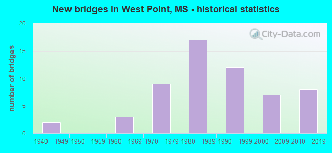
- New bridges - historical statistics
- 21940-1949
- 31960-1969
- 91970-1979
- 171980-1989
- 121990-1999
- 72000-2009
- 82010-2019
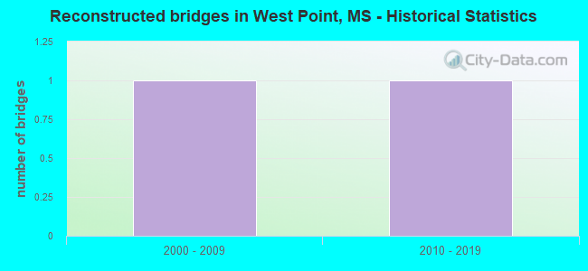
- Reconstructed bridges - Historical Statistics
- 12000-2009
- 12010-2019
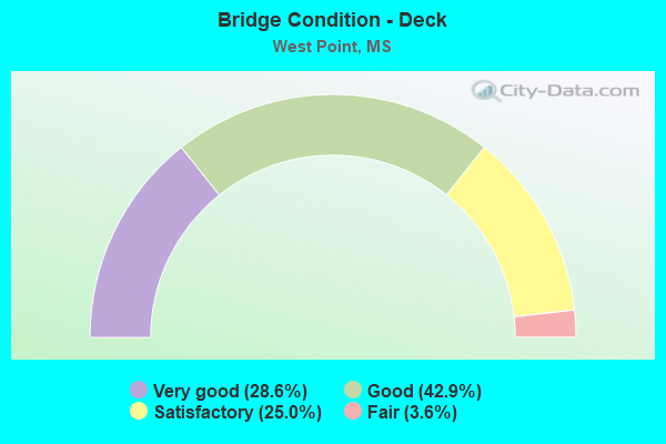
- Bridge Condition - Deck
- 28.6%Very good
- 42.9%Good
- 25.0%Satisfactory
- 3.6%Fair
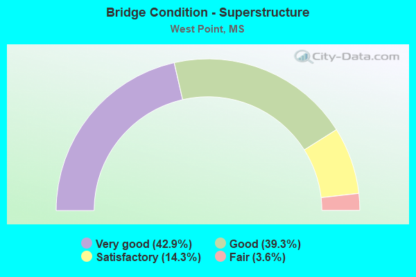
- Bridge Condition - Superstructure
- 42.9%Very good
- 39.3%Good
- 14.3%Satisfactory
- 3.6%Fair
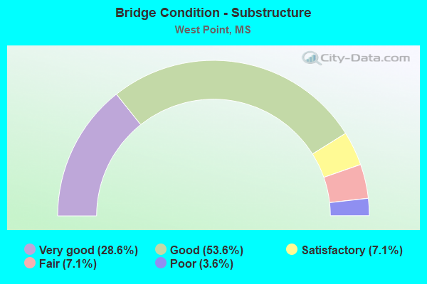
- Bridge Condition - Substructure
- 28.6%Very good
- 53.6%Good
- 7.1%Satisfactory
- 7.1%Fair
- 3.6%Poor
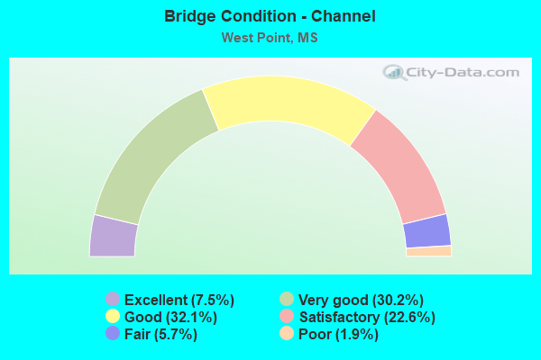
- Bridge Condition - Channel
- 7.5%Excellent
- 30.2%Very good
- 32.1%Good
- 22.6%Satisfactory
- 5.7%Fair
- 1.9%Poor
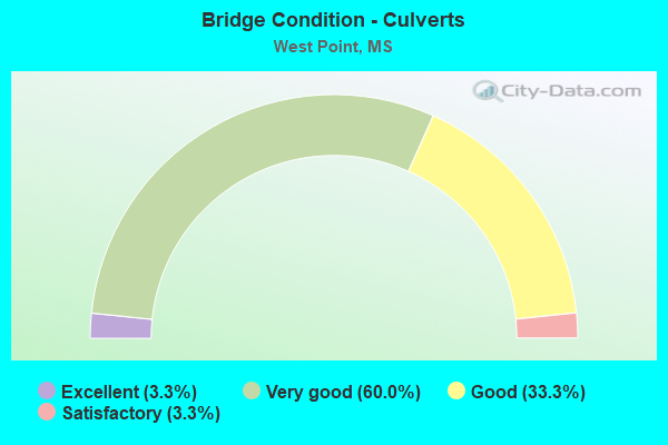
- Bridge Condition - Culverts
- 3.3%Excellent
- 60.0%Very good
- 33.3%Good
- 3.3%Satisfactory
Find on map >> Show street view
Structure Number: 22000450091922A, Location: 5.4 MI N MONROE CL (Lat: 33.943928, Lng: -88.726558), Route carried "on" structure: US 45A, Year Built: 1996, Status: Open, Structure Length: 6.93m (22.74ft), Average Daily Traffic: 4,950 (year 2020), Truck Traffic: 22%, Average Future Daily Traffic: 7,000 (year 2040), Design Load: HS 20, Features Intersected: KCS RR
Minimum Vertical Clearance: 30+ m (98+ ft), Kilometerpoint: 0.851, Lanes on structure: 2, Base Highway Network: Yes (Inventory Route: 45, Subroute: 1), Owner: State Highway Agency, Approaching Roadway Width: 12.8m (42.0ft), Skew: 12 degrees, Material/Design: Prestressed concrete continuous, Design/Construction: Stringer/Multi-beam, Number Of Spans In Main Unit: 3, Length of Maximum Span: 25.9m (85.0ft), Curb-To-Curb Width: 12.2m (40.0ft), Out-to-Out Width: 13.0m (42.7ft)
Condition: Deck: Good, Superstructure: Good, Substructure: Good, Operating Rating: 58.0 metric tons, Method Used To Determine Operating Rating: Load Factor (LF), Inventory Rating: 25.9 metric tons, Method Used To Determine Inventory Rating: Load Factor (LF), Structural Evaluation: Equal to present minimum criteria, Deck Geometry: Better than present minimum criteria, Underclear: Superior to present desirable criteria, Approach Roadway Alignment: Equal to present desirable criteria, Designated Inspection Frequency: Every 24 months, Inspection Date: January 2021, Deck Structure Type: Concrete Cast-file-Place
Find on map >> Show street view
Structure Number: 22000450131643A, Location: 3.1 MI N LOWNDES CL (Lat: 33.554425, Lng: -88.659244), Route carried "on" structure: US 45A, Year Built: 1992, Status: Open, Structure Length: 44.24m (145.14ft), Average Daily Traffic: 9,000 (year 2020), Truck Traffic: 18%, Average Future Daily Traffic: 12,000 (year 2040), Design Load: HS 20, Features Intersected: TIBBEE CREEK
Minimum Vertical Clearance: 30+ m (98+ ft), Kilometerpoint: 8.118, Lanes on structure: 2, Base Highway Network: Yes (Inventory Route: 45, Subroute: 2), Owner: State Highway Agency, Approaching Roadway Width: 12.8m (42.0ft), Skew: 10 degrees, Material/Design: Steel continuous, Design/Construction: Stringer/Multi-beam, Number Of Spans In Main Unit: 3, Number Of Approach Spans: 22, Length of Maximum Span: 48.8m (160.1ft), Curb-To-Curb Width: 12.2m (40.0ft), Out-to-Out Width: 13.0m (42.7ft)
Condition: Deck: Satisfactory, Superstructure: Good, Substructure: Good, Channel: Satisfactory, Operating Rating: 57.7 metric tons, Method Used To Determine Operating Rating: Load Factor (LF), Inventory Rating: 30.4 metric tons, Method Used To Determine Inventory Rating: Load Factor (LF), Structural Evaluation: Better than present minimum criteria, Deck Geometry: Better than present minimum criteria, Waterway Adequacy: Equal to present desirable criteria, Approach Roadway Alignment: Equal to present desirable criteria, Designated Inspection Frequency: Every 24 months, Inspection Date: October 2021, Deck Structure Type: Concrete Cast-file-Place
Find on map >> Show street view
Structure Number: 22000450131643B, Location: 3.1 MI N LOWNDES CL (Lat: 33.550439, Lng: -88.658942), Route carried "on" structure: US 45A, Year Built: 1992, Status: Open, Structure Length: 44.24m (145.14ft), Average Daily Traffic: 9,000 (year 2020), Truck Traffic: 18%, Average Future Daily Traffic: 12,000 (year 2040), Design Load: HS 20, Features Intersected: TIBBEE CREEK
Minimum Vertical Clearance: 30+ m (98+ ft), Kilometerpoint: 4.855, Lanes on structure: 2, Base Highway Network: Yes (Inventory Route: 45, Subroute: 1), Owner: State Highway Agency, Approaching Roadway Width: 12.8m (42.0ft), Skew: 10 degrees, Material/Design: Steel continuous, Design/Construction: Stringer/Multi-beam, Number Of Spans In Main Unit: 3, Number Of Approach Spans: 24, Length of Maximum Span: 48.8m (160.1ft), Curb-To-Curb Width: 12.2m (40.0ft), Out-to-Out Width: 13.0m (42.7ft)
Condition: Deck: Satisfactory, Superstructure: Very good, Substructure: Good, Channel: Satisfactory, Operating Rating: 57.7 metric tons, Method Used To Determine Operating Rating: Load Factor (LF), Inventory Rating: 31.0 metric tons, Method Used To Determine Inventory Rating: Load Factor (LF), Structural Evaluation: Better than present minimum criteria, Deck Geometry: Better than present minimum criteria, Waterway Adequacy: Equal to present desirable criteria, Approach Roadway Alignment: Equal to present desirable criteria, Designated Inspection Frequency: Every 24 months, Inspection Date: October 2021, Deck Structure Type: Concrete Cast-file-Place
Find on map >> Show street view
Structure Number: 22000450131662, Location: 2.0 MI S SR 50 (Lat: 33.578458, Lng: -88.659033), Route carried "on" structure: US 45A, Year Built: 1992, Status: Open, Structure Length: 1.38m (4.53ft), Average Daily Traffic: 18,000 (year 2020), Truck Traffic: 18%, Average Future Daily Traffic: 18,000 (year 2040), Design Load: HS 20, Features Intersected: TOWN CREEK
Minimum Vertical Clearance: 30+ m (98+ ft), Kilometerpoint: 7.965, Lanes on structure: 4, Base Highway Network: Yes (Inventory Route: 45, Subroute: 1), Owner: State Highway Agency, Approaching Roadway Width: 25.6m (84.0ft), Skew: 15 degrees, Material/Design: Concrete, Design/Construction: Culvert, Number Of Spans In Main Unit: 2, Length of Maximum Span: 4.3m (14.1ft)
Condition: Channel: Good, Culverts: Satisfactory, Operating Rating: 84.6 metric tons, Method Used To Determine Operating Rating: Load Factor (LF), Inventory Rating: 50.4 metric tons, Method Used To Determine Inventory Rating: Load Factor (LF), Structural Evaluation: Equal to present minimum criteria, Waterway Adequacy: Equal to present desirable criteria, Approach Roadway Alignment: Equal to present desirable criteria, Designated Inspection Frequency: Every 24 months, Inspection Date: October 2021
Find on map >> Show street view
Structure Number: 22000450131676, Location: 0.6 MI S SR 50 (Lat: 33.599192, Lng: -88.659067), Route carried "on" structure: US 45A, Year Built: 1973, Status: Open, Structure Length: 1.42m (4.66ft), Average Daily Traffic: 26,000 (year 2020), Truck Traffic: 12%, Average Future Daily Traffic: 26,000 (year 2040), Design Load: HS 20, Features Intersected: TOWN CREEK
Minimum Vertical Clearance: 30+ m (98+ ft), Kilometerpoint: 10.266, Lanes on structure: 5, Base Highway Network: Yes (Inventory Route: 45, Subroute: 1), Owner: State Highway Agency, Approaching Roadway Width: 19.5m (64.0ft), Skew: 4 degrees, Material/Design: Concrete, Design/Construction: Culvert, Number Of Spans In Main Unit: 2, Length of Maximum Span: 4.9m (16.1ft)
Condition: Channel: Good, Culverts: Good, Operating Rating: 48.7 metric tons, Method Used To Determine Operating Rating: Load Factor (LF), Inventory Rating: 25.8 metric tons, Method Used To Determine Inventory Rating: Load Factor (LF), Structural Evaluation: Equal to present minimum criteria, Waterway Adequacy: Equal to present desirable criteria, Approach Roadway Alignment: Equal to present desirable criteria, Designated Inspection Frequency: Every 24 months, Inspection Date: October 2021
Find on map >> Show street view
Structure Number: 22000450131704, Location: 2.2 MI N SR 50 (Lat: 33.639158, Lng: -88.662806), Route carried "on" structure: US 45A, Year Built: 1999, Status: Open, Structure Length: 1.59m (5.22ft), Average Daily Traffic: 14,000 (year 2020), Truck Traffic: 22%, Average Future Daily Traffic: 14,000 (year 2040), Design Load: HS 20, Features Intersected: CREEK
Minimum Vertical Clearance: 30+ m (98+ ft), Kilometerpoint: 14.766, Lanes on structure: 4, Base Highway Network: Yes (Inventory Route: 45, Subroute: 1), Owner: State Highway Agency, Approaching Roadway Width: 25.6m (84.0ft), Skew: 4 degrees, Material/Design: Concrete, Design/Construction: Culvert, Number Of Spans In Main Unit: 2, Length of Maximum Span: 5.5m (18.0ft)
Condition: Channel: Very good, Culverts: Good, Operating Rating: 42.4 metric tons, Method Used To Determine Operating Rating: Load Factor (LF), Inventory Rating: 28.4 metric tons, Method Used To Determine Inventory Rating: Load Factor (LF), Structural Evaluation: Better than present minimum criteria, Waterway Adequacy: Equal to present desirable criteria, Approach Roadway Alignment: Equal to present desirable criteria, Designated Inspection Frequency: Every 24 months, Inspection Date: October 2021
Find on map >> Show street view
Structure Number: 31000500130671, Location: 6.0 MI W US 45A (Lat: 33.610147, Lng: -88.758008), Route carried "on" structure: State highway 50, Year Built: 1986, Status: Open, Structure Length: 3.08m (10.10ft), Average Daily Traffic: 2,900 (year 2020), Truck Traffic: 8%, Average Future Daily Traffic: 2,900 (year 2040), Design Load: HS 20, Features Intersected: LONG CREEK
Minimum Vertical Clearance: 30+ m (98+ ft), Kilometerpoint: 25.407, Lanes on structure: 2, Base Highway Network: Yes (Inventory Route: 5, Subroute: 1), Owner: State Highway Agency, Approaching Roadway Width: 12.2m (40.0ft), Material/Design: Prestressed concrete continuous, Design/Construction: Stringer/Multi-beam, Number Of Spans In Main Unit: 1, Number Of Approach Spans: 2, Length of Maximum Span: 12.2m (40.0ft), Curb-To-Curb Width: 12.2m (40.0ft), Out-to-Out Width: 13.0m (42.7ft)
Condition: Deck: Good, Superstructure: Good, Substructure: Good, Channel: Satisfactory, Operating Rating: 58.5 metric tons, Method Used To Determine Operating Rating: Load Factor (LF), Inventory Rating: 35.0 metric tons, Method Used To Determine Inventory Rating: Load Factor (LF), Structural Evaluation: Better than present minimum criteria, Deck Geometry: Equal to present minimum criteria, Waterway Adequacy: Superior to present desirable criteria, Approach Roadway Alignment: Equal to present desirable criteria, Designated Inspection Frequency: Every 24 months, Inspection Date: October 2021, Deck Structure Type: Concrete Cast-file-Place
Find on map >> Show street view
Structure Number: 31000500130673, Location: 5.9 MI W US 45A (Lat: 33.610144, Lng: -88.756022), Route carried "on" structure: State highway 50, Year Built: 1986, Status: Open, Structure Length: 3.71m (12.17ft), Average Daily Traffic: 2,900 (year 2020), Truck Traffic: 8%, Average Future Daily Traffic: 2,900 (year 2040), Design Load: HS 20, Features Intersected: RELIEF
Minimum Vertical Clearance: 30+ m (98+ ft), Kilometerpoint: 25.590, Lanes on structure: 2, Base Highway Network: Yes (Inventory Route: 5, Subroute: 1), Owner: State Highway Agency, Approaching Roadway Width: 12.2m (40.0ft), Material/Design: Prestressed concrete continuous, Design/Construction: Stringer/Multi-beam, Number Of Spans In Main Unit: 3, Length of Maximum Span: 12.2m (40.0ft), Curb-To-Curb Width: 12.2m (40.0ft), Out-to-Out Width: 13.0m (42.7ft)
Condition: Deck: Good, Superstructure: Very good, Substructure: Good, Channel: Good, Operating Rating: 57.5 metric tons, Method Used To Determine Operating Rating: Load Factor (LF), Inventory Rating: 34.4 metric tons, Method Used To Determine Inventory Rating: Load Factor (LF), Structural Evaluation: Better than present minimum criteria, Deck Geometry: Equal to present minimum criteria, Waterway Adequacy: Equal to present desirable criteria, Approach Roadway Alignment: Equal to present desirable criteria, Designated Inspection Frequency: Every 24 months, Underwater Inspection Frequency: Every 60 months, Inspection Date: October 2021, Underwater Inspection Date: September 2019, Deck Structure Type: Concrete Cast-file-Place
Find on map >> Show street view
Structure Number: 31000500130684, Location: 4.8 MI W US 45A (Lat: 33.607994, Lng: -88.735728), Route carried "on" structure: State highway 50, Year Built: 1986, Status: Open, Structure Length: 0.72m (2.36ft), Average Daily Traffic: 4,100 (year 2020), Truck Traffic: 7%, Average Future Daily Traffic: 4,100 (year 2040), Design Load: HS 20, Features Intersected: STREAM
Minimum Vertical Clearance: 30+ m (98+ ft), Kilometerpoint: 27.500, Lanes on structure: 2, Base Highway Network: Yes (Inventory Route: 5, Subroute: 1), Owner: State Highway Agency, Approaching Roadway Width: 12.2m (40.0ft), Skew: 4 degrees, Material/Design: Concrete, Design/Construction: Culvert, Number Of Spans In Main Unit: 2, Length of Maximum Span: 2.4m (7.9ft)
Condition: Channel: Very good, Culverts: Good, Operating Rating: 99.8 metric tons, Method Used To Determine Operating Rating: Load Factor (LF), Inventory Rating: 82.3 metric tons, Method Used To Determine Inventory Rating: Load Factor (LF), Structural Evaluation: Better than present minimum criteria, Waterway Adequacy: Superior to present desirable criteria, Approach Roadway Alignment: Equal to present desirable criteria, Designated Inspection Frequency: Every 24 months, Inspection Date: October 2021
Find on map >> Show street view
Structure Number: 31000500130693, Location: 3.9 MI W US 45A (Lat: 33.607303, Lng: -88.721692), Route carried "on" structure: State highway 50, Year Built: 1940, Status: Open, Structure Length: 9.14m (29.99ft), Average Daily Traffic: 4,100 (year 2020), Truck Traffic: 7%, Average Future Daily Traffic: 4,100 (year 2040), Design Load: H 15, Features Intersected: CHUQUATONCHEE RELIEF
Minimum Vertical Clearance: 30+ m (98+ ft), Kilometerpoint: 28.812, Lanes on structure: 2, Base Highway Network: Yes (Inventory Route: 5, Subroute: 1), Owner: State Highway Agency, Approaching Roadway Width: 9.1m (29.9ft), Material/Design: Steel, Design/Construction: Stringer/Multi-beam, Number Of Spans In Main Unit: 10, Length of Maximum Span: 9.1m (29.9ft), Curb or Sidewalk Widths: Left: 0.2m (0.7ft), Right: 0.2m (0.7ft), Curb-To-Curb Width: 7.3m (24.0ft), Out-to-Out Width: 8.1m (26.6ft)
Condition: Deck: Satisfactory, Superstructure: Satisfactory, Substructure: Fair, Channel: Satisfactory, Operating Rating: 41.7 metric tons, Method Used To Determine Operating Rating: Load Factor (LF), Inventory Rating: 24.9 metric tons, Method Used To Determine Inventory Rating: Load Factor (LF), Structural Evaluation: Somewhat better than minimum adequacy, Deck Geometry: High priority of replacement, Waterway Adequacy: Equal to present minimum criteria, Approach Roadway Alignment: Equal to present desirable criteria, Length Of Structure Improvement: 11.64m (38.19ft), Designated Inspection Frequency: Every 24 months, Inspection Date: October 2021, Bridge Improvement Cost: $999,999,000, Roadway Improvement Cost: $109,000,000, Total Project Cost: $999,999,000, Deck Structure Type: Concrete Cast-file-Place
Find on map >> Show street view
Structure Number: 31000500130699, Location: 3.2 MI W US 45A (Lat: 33.607428, Lng: -88.710169), Route carried "on" structure: State highway 50, Year Built: 1940, Status: Open, Structure Length: 22.56m (74.02ft), Average Daily Traffic: 4,100 (year 2020), Truck Traffic: 7%, Average Future Daily Traffic: 4,100 (year 2040), Design Load: H 15, Features Intersected: CHUQUATONCHEE CREEK
Minimum Vertical Clearance: 30+ m (98+ ft), Kilometerpoint: 29.882, Lanes on structure: 2, Base Highway Network: Yes (Inventory Route: 5, Subroute: 1), Owner: State Highway Agency, Approaching Roadway Width: 9.1m (29.9ft), Material/Design: Steel, Design/Construction: Stringer/Multi-beam, Number Of Spans In Main Unit: 3, Number Of Approach Spans: 18, Length of Maximum Span: 24.4m (80.1ft), Curb or Sidewalk Widths: Left: 0.2m (0.7ft), Right: 0.2m (0.7ft), Curb-To-Curb Width: 7.3m (24.0ft), Out-to-Out Width: 8.1m (26.6ft)
Condition: Deck: Satisfactory, Superstructure: Satisfactory, Substructure: Satisfactory, Channel: Satisfactory, Operating Rating: 39.0 metric tons, Method Used To Determine Operating Rating: Load Factor (LF), Inventory Rating: 23.3 metric tons, Method Used To Determine Inventory Rating: Load Factor (LF), Structural Evaluation: Equal to present minimum criteria, Deck Geometry: High priority of replacement, Waterway Adequacy: Superior to present desirable criteria, Approach Roadway Alignment: Equal to present desirable criteria, Length Of Structure Improvement: 27.43m (89.99ft), Designated Inspection Frequency: Every 24 months, Inspection Date: October 2021, Bridge Improvement Cost: $999,999,000, Roadway Improvement Cost: $270,000,000, Total Project Cost: $999,999,000, Deck Structure Type: Concrete Cast-file-Place
Find on map >> Show street view
Structure Number: 31000500130716, Location: 1.6 MI W US 45A (Lat: 33.607183, Lng: -88.681036), Route carried "on" structure: State highway 50, Year Built: 1986, Status: Open, Structure Length: 1.16m (3.81ft), Average Daily Traffic: 5,500 (year 2020), Truck Traffic: 5%, Average Future Daily Traffic: 5,700 (year 2040), Design Load: HS 20, Features Intersected: STREAM
Minimum Vertical Clearance: 30+ m (98+ ft), Kilometerpoint: 32.586, Lanes on structure: 2, Base Highway Network: Yes (Inventory Route: 5, Subroute: 1), Owner: State Highway Agency, Approaching Roadway Width: 12.2m (40.0ft), Skew: 3 degrees, Material/Design: Concrete, Design/Construction: Culvert, Number Of Spans In Main Unit: 2, Length of Maximum Span: 4.9m (16.1ft)
Condition: Channel: Good, Culverts: Good, Operating Rating: 52.7 metric tons, Method Used To Determine Operating Rating: Load Factor (LF), Inventory Rating: 31.6 metric tons, Method Used To Determine Inventory Rating: Load Factor (LF), Structural Evaluation: Better than present minimum criteria, Waterway Adequacy: Superior to present desirable criteria, Approach Roadway Alignment: Equal to present desirable criteria, Designated Inspection Frequency: Every 24 months, Inspection Date: October 2021
Find on map >> Show street view
Structure Number: 31000500130724, Location: 0.8 MI W US 45A (Lat: 33.607147, Lng: -88.667328), Route carried "on" structure: State highway 50, Year Built: 1986, Status: Open, Structure Length: 0.63m (2.07ft), Average Daily Traffic: 5,500 (year 2020), Truck Traffic: 5%, Average Future Daily Traffic: 5,700 (year 2040), Design Load: HS 20, Features Intersected: CREEK
Minimum Vertical Clearance: 30+ m (98+ ft), Kilometerpoint: 33.857, Lanes on structure: 2, Base Highway Network: Yes (Inventory Route: 5, Subroute: 1), Owner: State Highway Agency, Approaching Roadway Width: 12.2m (40.0ft), Material/Design: Concrete, Design/Construction: Culvert, Number Of Spans In Main Unit: 2, Length of Maximum Span: 3.0m (9.8ft)
Condition: Channel: Good, Culverts: Good, Operating Rating: 74.1 metric tons, Method Used To Determine Operating Rating: Load Factor (LF), Inventory Rating: 44.3 metric tons, Method Used To Determine Inventory Rating: Load Factor (LF), Structural Evaluation: Better than present minimum criteria, Waterway Adequacy: Equal to present desirable criteria, Approach Roadway Alignment: Equal to present desirable criteria, Designated Inspection Frequency: Every 24 months, Inspection Date: October 2021
Find on map >> Show street view
Structure Number: 31000500130748, Location: 1.8 MI E US 45A (Lat: 33.607125, Lng: -88.628894), Route carried "on" structure: State highway 50, Year Built: 1986, Status: Open, Structure Length: 0.63m (2.07ft), Average Daily Traffic: 5,100 (year 2020), Truck Traffic: 4%, Average Future Daily Traffic: 5,300 (year 2040), Design Load: HS 20, Features Intersected: STREAM
Minimum Vertical Clearance: 30+ m (98+ ft), Kilometerpoint: 37.425, Lanes on structure: 2, Base Highway Network: Yes (Inventory Route: 5, Subroute: 1), Owner: State Highway Agency, Approaching Roadway Width: 12.2m (40.0ft), Material/Design: Concrete, Design/Construction: Culvert, Number Of Spans In Main Unit: 2, Length of Maximum Span: 3.0m (9.8ft)
Condition: Channel: Satisfactory, Culverts: Good, Operating Rating: 33.2 metric tons, Method Used To Determine Operating Rating: Load Factor (LF), Inventory Rating: 20.0 metric tons, Method Used To Determine Inventory Rating: Load Factor (LF), Structural Evaluation: Somewhat better than minimum adequacy, Waterway Adequacy: Superior to present desirable criteria, Approach Roadway Alignment: Equal to present desirable criteria, Designated Inspection Frequency: Every 24 months, Inspection Date: October 2021
Find on map >> Show street view
Structure Number: 31000500130758, Location: 2.8 MI E US 45A (Lat: 33.607314, Lng: -88.609567), Route carried "on" structure: State highway 50, Year Built: 1986, Status: Open, Structure Length: 3.73m (12.24ft), Average Daily Traffic: 5,100 (year 2020), Truck Traffic: 4%, Average Future Daily Traffic: 5,100 (year 2040), Design Load: HS 20, Features Intersected: MCGEE CREEK
Minimum Vertical Clearance: 30+ m (98+ ft), Kilometerpoint: 39.220, Lanes on structure: 2, Base Highway Network: Yes (Inventory Route: 5, Subroute: 1), Owner: State Highway Agency, Approaching Roadway Width: 12.2m (40.0ft), Material/Design: Prestressed concrete continuous, Design/Construction: Stringer/Multi-beam, Number Of Spans In Main Unit: 2, Length of Maximum Span: 18.3m (60.0ft), Curb-To-Curb Width: 12.2m (40.0ft), Out-to-Out Width: 13.0m (42.7ft)
Condition: Deck: Good, Superstructure: Very good, Substructure: Good, Channel: Good, Operating Rating: 53.9 metric tons, Method Used To Determine Operating Rating: Load Factor (LF), Inventory Rating: 27.3 metric tons, Method Used To Determine Inventory Rating: Load Factor (LF), Structural Evaluation: Equal to present minimum criteria, Deck Geometry: Somewhat better than minimum adequacy, Waterway Adequacy: Equal to present desirable criteria, Approach Roadway Alignment: Equal to present desirable criteria, Designated Inspection Frequency: Every 24 months, Inspection Date: October 2021, Deck Structure Type: Concrete Cast-file-Place
Find on map >> Show street view
Structure Number: 31000500130759, Location: 2.9 MI E US 45A (Lat: 33.607333, Lng: -88.607461), Route carried "on" structure: State highway 50, Year Built: 1986, Status: Open, Structure Length: 0.63m (2.07ft), Average Daily Traffic: 5,100 (year 2020), Truck Traffic: 4%, Average Future Daily Traffic: 5,100 (year 2040), Design Load: HS 20, Features Intersected: MCGEE CREEK RELIEF
Minimum Vertical Clearance: 30+ m (98+ ft), Kilometerpoint: 39.414, Lanes on structure: 2, Base Highway Network: Yes (Inventory Route: 5, Subroute: 1), Owner: State Highway Agency, Approaching Roadway Width: 12.2m (40.0ft), Material/Design: Concrete, Design/Construction: Culvert, Number Of Spans In Main Unit: 2, Length of Maximum Span: 3.0m (9.8ft)
Condition: Channel: Very good, Culverts: Good, Operating Rating: 65.1 metric tons, Method Used To Determine Operating Rating: Load Factor (LF), Inventory Rating: 39.1 metric tons, Method Used To Determine Inventory Rating: Load Factor (LF), Structural Evaluation: Better than present minimum criteria, Waterway Adequacy: Superior to present desirable criteria, Approach Roadway Alignment: Equal to present desirable criteria, Designated Inspection Frequency: Every 24 months, Inspection Date: October 2021
Find on map >> Show street view
Structure Number: 31000500130765, Location: 3.5 MI E US 45A (Lat: 33.607197, Lng: -88.596883), Route carried "on" structure: State highway 50, Year Built: 1986, Status: Open, Structure Length: 0.75m (2.46ft), Average Daily Traffic: 5,100 (year 2020), Truck Traffic: 4%, Average Future Daily Traffic: 5,100 (year 2040), Design Load: HS 20, Features Intersected: DITCH
Minimum Vertical Clearance: 30+ m (98+ ft), Kilometerpoint: 40.396, Lanes on structure: 2, Base Highway Network: Yes (Inventory Route: 5, Subroute: 1), Owner: State Highway Agency, Approaching Roadway Width: 12.2m (40.0ft), Skew: 4 degrees, Material/Design: Concrete, Design/Construction: Culvert, Number Of Spans In Main Unit: 2, Length of Maximum Span: 2.4m (7.9ft)
Condition: Channel: Satisfactory, Culverts: Good, Operating Rating: 84.6 metric tons, Method Used To Determine Operating Rating: Load Factor (LF), Inventory Rating: 50.7 metric tons, Method Used To Determine Inventory Rating: Load Factor (LF), Structural Evaluation: Better than present minimum criteria, Waterway Adequacy: Equal to present desirable criteria, Approach Roadway Alignment: Equal to present desirable criteria, Designated Inspection Frequency: Every 24 months, Inspection Date: October 2021
Find on map >> Show street view
Structure Number: 31000500130776, Location: 4.6 MI E US 45A (Lat: 33.607147, Lng: -88.577814), Route carried "on" structure: State highway 50, Year Built: 1986, Status: Open, Structure Length: 0.79m (2.59ft), Average Daily Traffic: 5,100 (year 2020), Truck Traffic: 4%, Average Future Daily Traffic: 5,100 (year 2040), Design Load: HS 20, Features Intersected: SPRING CREEK
Minimum Vertical Clearance: 30+ m (98+ ft), Kilometerpoint: 42.168, Lanes on structure: 2, Base Highway Network: Yes (Inventory Route: 5, Subroute: 1), Owner: State Highway Agency, Approaching Roadway Width: 12.2m (40.0ft), Skew: 1 degrees, Material/Design: Concrete, Design/Construction: Culvert, Number Of Spans In Main Unit: 2, Length of Maximum Span: 3.7m (12.1ft)
Condition: Channel: Satisfactory, Culverts: Good, Operating Rating: 73.8 metric tons, Method Used To Determine Operating Rating: Load Factor (LF), Inventory Rating: 44.2 metric tons, Method Used To Determine Inventory Rating: Load Factor (LF), Structural Evaluation: Better than present minimum criteria, Waterway Adequacy: Superior to present desirable criteria, Approach Roadway Alignment: Equal to present desirable criteria, Designated Inspection Frequency: Every 24 months, Inspection Date: October 2021
Find on map >> Show street view
Structure Number: 31000500130782, Location: 5.2 MI E US 45A (Lat: 33.607114, Lng: -88.568275), Route carried "on" structure: State highway 50, Year Built: 1986, Status: Open, Structure Length: 0.65m (2.13ft), Average Daily Traffic: 5,100 (year 2020), Truck Traffic: 4%, Average Future Daily Traffic: 5,100 (year 2040), Design Load: HS 20, Features Intersected: STREAM
Minimum Vertical Clearance: 30+ m (98+ ft), Kilometerpoint: 43.053, Lanes on structure: 2, Base Highway Network: Yes (Inventory Route: 5, Subroute: 1), Owner: State Highway Agency, Approaching Roadway Width: 12.2m (40.0ft), Skew: 1 degrees, Material/Design: Concrete, Design/Construction: Culvert, Number Of Spans In Main Unit: 2, Length of Maximum Span: 3.0m (9.8ft)
Condition: Channel: Satisfactory, Culverts: Good, Operating Rating: 99.8 metric tons, Method Used To Determine Operating Rating: Load Factor (LF), Inventory Rating: 92.9 metric tons, Method Used To Determine Inventory Rating: Load Factor (LF), Structural Evaluation: Better than present minimum criteria, Waterway Adequacy: Superior to present desirable criteria, Approach Roadway Alignment: Equal to present desirable criteria, Designated Inspection Frequency: Every 24 months, Inspection Date: October 2021
Find on map >> Show street view
Structure Number: SA1300000000001, Location: SEC 25 T15S R 3E (Lat: 33.746944, Lng: -88.936944), Route carried "on" structure: County highway 7, Year Built: 1965, Year Reconstructed: 2013, Status: Open, Structure Length: 0.95m (3.12ft), Average Daily Traffic: 100 (year 2021), Truck Traffic: 8%, Average Future Daily Traffic: 150 (year 2043), Design Load: HS 20+Mod, Features Intersected: STANDING CREEK, Facility Carried by Structure: JOE STEVENS ROAD
Minimum Vertical Clearance: 30+ m (98+ ft), Kilometerpoint: 0.965, Lanes on structure: 2, Owner: County Highway Agency, Approaching Roadway Width: 8.5m (27.9ft), Skew: 1 degrees, Material/Design: Concrete, Design/Construction: Culvert, Number Of Spans In Main Unit: 2, Length of Maximum Span: 4.3m (14.1ft), Curb-To-Curb Width: 16.0m (52.5ft), Out-to-Out Width: 16.5m (54.1ft)
Condition: Channel: Good, Culverts: Excellent, Operating Rating: 47.4 metric tons, Method Used To Determine Operating Rating: Load Factor (LF), Inventory Rating: 28.5 metric tons, Method Used To Determine Inventory Rating: Load Factor (LF), Structural Evaluation: Better than present minimum criteria, Waterway Adequacy: Better than present minimum criteria, Approach Roadway Alignment: Better than present minimum criteria, Designated Inspection Frequency: Every 24 months, Inspection Date: December 2021, Deck Structure Type: Concrete Cast-file-Place, Wearing Surface/Protective System: Wearing Surface: Gravel
Find on map >> Show street view
Structure Number: SA1300000000061, Location: SEC 20 T16S R 6E (Lat: 33.668056, Lng: -88.695000), Route carried "on" structure: County highway 110, Year Built: 2003, Status: Open, Structure Length: 1.18m (3.87ft), Average Daily Traffic: 25 (year 2018), Average Future Daily Traffic: 35 (year 2038), Design Load: HS 20, Features Intersected: TRIB OF CHUQUATONCHE CR, Facility Carried by Structure: JAMESON ROAD
Minimum Vertical Clearance: 30+ m (98+ ft), Kilometerpoint: 0.321, Lanes on structure: 2, Owner: County Highway Agency, Approaching Roadway Width: 8.5m (27.9ft), Material/Design: Concrete, Design/Construction: Culvert, Number Of Spans In Main Unit: 2, Length of Maximum Span: 5.5m (18.0ft)
Condition: Channel: Very good, Culverts: Very good, Operating Rating: 56.5 metric tons, Method Used To Determine Operating Rating: Load Factor (LF), Inventory Rating: 34.0 metric tons, Method Used To Determine Inventory Rating: Load Factor (LF), Structural Evaluation: Equal to present desirable criteria, Waterway Adequacy: Equal to present desirable criteria, Approach Roadway Alignment: Equal to present desirable criteria, Designated Inspection Frequency: Every 24 months, Inspection Date: April 2021
Find on map >> Show street view
Structure Number: SA1300000000062, Location: SEC 24 T16S R 6E B (Lat: 33.665556, Lng: -88.631667), Route carried "on" structure: County highway 170, Year Built: 2003, Status: Open, Structure Length: 0.95m (3.12ft), Average Daily Traffic: 50 (year 2021), Truck Traffic: 8%, Average Future Daily Traffic: 75 (year 2043), Design Load: HS 20, Features Intersected: VINTON BRANCH, Facility Carried by Structure: OLD VINTON ROAD
Minimum Vertical Clearance: 30+ m (98+ ft), Kilometerpoint: 0.160, Lanes on structure: 2, Owner: County Highway Agency, Approaching Roadway Width: 8.5m (27.9ft), Skew: 1 degrees, Material/Design: Concrete, Design/Construction: Culvert, Number Of Spans In Main Unit: 2, Length of Maximum Span: 4.3m (14.1ft)
Condition: Channel: Very good, Culverts: Very good, Operating Rating: 54.6 metric tons, Method Used To Determine Operating Rating: Load Factor (LF), Inventory Rating: 32.7 metric tons, Method Used To Determine Inventory Rating: Load Factor (LF), Structural Evaluation: Equal to present desirable criteria, Waterway Adequacy: Better than present minimum criteria, Approach Roadway Alignment: Better than present minimum criteria, Designated Inspection Frequency: Every 24 months, Inspection Date: December 2021
Find on map >> Show street view
Structure Number: SA1300000000063, Location: SEC 24 T16S R 6E B (Lat: 33.665914, Lng: -88.618819), Route carried "on" structure: County highway 170, Year Built: 1997, Status: Open, Structure Length: 0.79m (2.59ft), Average Daily Traffic: 50 (year 2021), Truck Traffic: 8%, Average Future Daily Traffic: 75 (year 2043), Design Load: HS 20, Features Intersected: VINTON CREEK, Facility Carried by Structure: OLD VINTON ROAD
Minimum Vertical Clearance: 30+ m (98+ ft), Kilometerpoint: 1.287, Lanes on structure: 2, Owner: County Highway Agency, Approaching Roadway Width: 6.9m (22.6ft), Material/Design: Concrete, Design/Construction: Culvert, Number Of Spans In Main Unit: 2, Length of Maximum Span: 3.7m (12.1ft), Curb-To-Curb Width: 7.9m (25.9ft), Out-to-Out Width: 8.5m (27.9ft)
Condition: Channel: Very good, Culverts: Very good, Operating Rating: 66.3 metric tons, Method Used To Determine Operating Rating: Load Factor (LF), Inventory Rating: 39.9 metric tons, Method Used To Determine Inventory Rating: Load Factor (LF), Structural Evaluation: Equal to present desirable criteria, Deck Geometry: Equal to present minimum criteria, Waterway Adequacy: Better than present minimum criteria, Approach Roadway Alignment: Equal to present desirable criteria, Designated Inspection Frequency: Every 24 months, Inspection Date: December 2021
Find on map >> Show street view
Structure Number: SA1300000000064, Location: SEC 25 T16S R 6E B (Lat: 33.651194, Lng: -88.623786), Route carried "on" structure: County highway 172, Year Built: 1993, Status: Open, Structure Length: 0.73m (2.40ft), Average Daily Traffic: 950 (year 2021), Truck Traffic: 8%, Average Future Daily Traffic: 1,450 (year 2043), Design Load: HS 20+Mod, Features Intersected: MCGEE CREEK, Facility Carried by Structure: HAZELWOOD ROAD
Minimum Vertical Clearance: 30+ m (98+ ft), Kilometerpoint: 0.804, Lanes on structure: 2, Owner: County Highway Agency, Approaching Roadway Width: 10.4m (34.1ft), Skew: 1 degrees, Material/Design: Concrete, Design/Construction: Culvert, Number Of Spans In Main Unit: 2, Length of Maximum Span: 3.7m (12.1ft), Curb-To-Curb Width: 19.5m (64.0ft), Out-to-Out Width: 19.8m (65.0ft)
Condition: Channel: Very good, Culverts: Very good, Operating Rating: 60.1 metric tons, Method Used To Determine Operating Rating: Load Factor (LF), Inventory Rating: 36.0 metric tons, Method Used To Determine Inventory Rating: Load Factor (LF), Structural Evaluation: Equal to present desirable criteria, Deck Geometry: Superior to present desirable criteria, Waterway Adequacy: Equal to present desirable criteria, Approach Roadway Alignment: Equal to present desirable criteria, Designated Inspection Frequency: Every 24 months, Inspection Date: December 2021, Deck Structure Type: Concrete Cast-file-Place, Wearing Surface/Protective System: Wearing Surface: Bituminous
Find on map >> Show street view
Structure Number: SA1300000000065, Location: SEC 25 T16S R 6E B (Lat: 33.651353, Lng: -88.618156), Route carried "on" structure: County highway 172, Year Built: 1993, Status: Open, Structure Length: 0.73m (2.40ft), Average Daily Traffic: 950 (year 2021), Truck Traffic: 8%, Average Future Daily Traffic: 1,425 (year 2043), Design Load: HS 20+Mod, Features Intersected: MCGEE CREEK, Facility Carried by Structure: HAZELWOOD ROAD
Minimum Vertical Clearance: 30+ m (98+ ft), Kilometerpoint: 1.287, Lanes on structure: 2, Owner: County Highway Agency, Approaching Roadway Width: 10.4m (34.1ft), Material/Design: Concrete, Design/Construction: Culvert, Number Of Spans In Main Unit: 2, Length of Maximum Span: 3.7m (12.1ft), Curb-To-Curb Width: 17.1m (56.1ft), Out-to-Out Width: 17.4m (57.1ft)
Condition: Channel: Very good, Culverts: Very good, Operating Rating: 61.8 metric tons, Method Used To Determine Operating Rating: Load Factor (LF), Inventory Rating: 36.9 metric tons, Method Used To Determine Inventory Rating: Load Factor (LF), Structural Evaluation: Equal to present desirable criteria, Deck Geometry: Superior to present desirable criteria, Waterway Adequacy: Equal to present desirable criteria, Approach Roadway Alignment: Equal to present desirable criteria, Designated Inspection Frequency: Every 24 months, Inspection Date: December 2021, Deck Structure Type: Concrete Cast-file-Place, Wearing Surface/Protective System: Wearing Surface: Bituminous
Find on map >> Show street view
Structure Number: SA1300000000066, Location: SEC 33 T16S R 6E (Lat: 33.643722, Lng: -88.681367), Route carried "on" structure: County highway 113, Year Built: 2001, Status: Open, Structure Length: 1.30m (4.27ft), Average Daily Traffic: 50 (year 2021), Truck Traffic: 8%, Average Future Daily Traffic: 60 (year 2043), Design Load: HS 20, Features Intersected: BOBCAT CREEK, Facility Carried by Structure: OLD BOBCAT ROAD
Minimum Vertical Clearance: 30+ m (98+ ft), Kilometerpoint: 1.609, Lanes on structure: 2, Owner: County Highway Agency, Approaching Roadway Width: 8.5m (27.9ft), Skew: 4 degrees, Material/Design: Concrete, Design/Construction: Culvert, Number Of Spans In Main Unit: 2, Length of Maximum Span: 4.3m (14.1ft), Curb-To-Curb Width: 17.0m (55.8ft), Out-to-Out Width: 17.3m (56.8ft)
Condition: Channel: Good, Culverts: Very good, Operating Rating: 58.0 metric tons, Method Used To Determine Operating Rating: Load Factor (LF) rating reported by rating factor (RF) method using MS18 loading, Inventory Rating: 34.7 metric tons, Method Used To Determine Inventory Rating: Load Factor (LF) rating reported by rating factor (RF) method using MS18 loading, Structural Evaluation: Equal to present desirable criteria, Deck Geometry: Superior to present desirable criteria, Waterway Adequacy: Better than present minimum criteria, Approach Roadway Alignment: Better than present minimum criteria, Designated Inspection Frequency: Every 24 months, Inspection Date: December 2021
Find on map >> Show street view
Structure Number: SA1300000000068, Location: SEC 20 T16S R 7E (Lat: 33.666017, Lng: -88.580003), Route carried "on" structure: County highway 173, Year Built: 2003, Status: Open, Structure Length: 3.66m (12.01ft), Average Daily Traffic: 50 (year 2021), Truck Traffic: 8%, Average Future Daily Traffic: 75 (year 2043), Design Load: HS 20, Features Intersected: TOWN CREEK, Facility Carried by Structure: OLD VINTON ROAD
Minimum Vertical Clearance: 30+ m (98+ ft), Kilometerpoint: 1.448, Lanes on structure: 2, Owner: County Highway Agency, Approaching Roadway Width: 8.5m (27.9ft), Material/Design: Prestressed concrete, Design/Construction: Stringer/Multi-beam, Number Of Spans In Main Unit: 3, Length of Maximum Span: 12.2m (40.0ft), Curb-To-Curb Width: 7.9m (25.9ft), Out-to-Out Width: 8.8m (28.9ft)
Condition: Deck: Very good, Superstructure: Very good, Substructure: Very good, Channel: Good, Operating Rating: 65.0 metric tons, Method Used To Determine Operating Rating: Load Factor (LF), Inventory Rating: 34.3 metric tons, Method Used To Determine Inventory Rating: Load Factor (LF), Structural Evaluation: Equal to present desirable criteria, Deck Geometry: Equal to present minimum criteria, Waterway Adequacy: Better than present minimum criteria, Approach Roadway Alignment: Better than present minimum criteria, Designated Inspection Frequency: Every 24 months, Inspection Date: December 2021, Deck Structure Type: Concrete Cast-file-Place, Wearing Surface/Protective System: Wearing Surface: Monolithic Concrete
Find on map >> Show street view
Structure Number: SA1300000000077, Location: SEC 10 T17S R 5E (Lat: 33.616836, Lng: -88.760239), Route carried "on" structure: County highway 20, Year Built: 1997, Status: Open, Structure Length: 2.83m (9.28ft), Average Daily Traffic: 50 (year 2021), Truck Traffic: 8%, Average Future Daily Traffic: 60 (year 2043), Design Load: HS 20, Features Intersected: LONG CREEK TRIBUTARY, Facility Carried by Structure: OLD HIGHWAY #10
Minimum Vertical Clearance: 30+ m (98+ ft), Kilometerpoint: 2.896, Lanes on structure: 2, Owner: County Highway Agency, Approaching Roadway Width: 7.9m (25.9ft), Material/Design: Concrete, Design/Construction: Channel Beam, Number Of Spans In Main Unit: 3, Length of Maximum Span: 9.4m (30.8ft), Curb-To-Curb Width: 7.3m (24.0ft), Out-to-Out Width: 7.8m (25.6ft)
Condition: Deck: Very good, Superstructure: Very good, Substructure: Very good, Channel: Very good, Operating Rating: 73.8 metric tons, Method Used To Determine Operating Rating: Load Factor (LF), Inventory Rating: 44.1 metric tons, Method Used To Determine Inventory Rating: Load Factor (LF), Structural Evaluation: Equal to present desirable criteria, Deck Geometry: Equal to present minimum criteria, Waterway Adequacy: Better than present minimum criteria, Approach Roadway Alignment: Equal to present desirable criteria, Designated Inspection Frequency: Every 24 months, Inspection Date: December 2021, Deck Structure Type: Concrete Cast-file-Place, Wearing Surface/Protective System: Wearing Surface: Gravel
Find on map >> Show street view
Structure Number: SA1300000000078, Location: SEC 11 T17S R 5E (Lat: 33.617500, Lng: -88.757778), Route carried "on" structure: County highway 20, Year Built: 2009, Status: Open, Structure Length: 0.95m (3.12ft), Average Daily Traffic: 50 (year 2021), Truck Traffic: 8%, Average Future Daily Traffic: 75 (year 2043), Design Load: HS 20, Features Intersected: LONG CREEK TRIBUTARY, Facility Carried by Structure: OLD HWY #10
Minimum Vertical Clearance: 30+ m (98+ ft), Kilometerpoint: 3.057, Lanes on structure: 2, Owner: County Highway Agency, Approaching Roadway Width: 8.5m (27.9ft), Skew: 1 degrees, Material/Design: Concrete, Design/Construction: Culvert, Number Of Spans In Main Unit: 2, Length of Maximum Span: 4.3m (14.1ft), Curb-To-Curb Width: 14.3m (46.9ft), Out-to-Out Width: 14.8m (48.6ft)
Condition: Channel: Good, Culverts: Very good, Operating Rating: 46.1 metric tons, Method Used To Determine Operating Rating: Load Factor (LF), Inventory Rating: 27.5 metric tons, Method Used To Determine Inventory Rating: Load Factor (LF), Structural Evaluation: Equal to present minimum criteria, Deck Geometry: Superior to present desirable criteria, Waterway Adequacy: Equal to present desirable criteria, Approach Roadway Alignment: Equal to present desirable criteria, Designated Inspection Frequency: Every 24 months, Inspection Date: December 2021, Deck Structure Type: Concrete Cast-file-Place, Wearing Surface/Protective System: Wearing Surface: Gravel
Find on map >> Show street view
Structure Number: SA1300000000079, Location: SEC 14 T17S R 5E (Lat: 33.600156, Lng: -88.757692), Route carried "on" structure: County highway 88, Year Built: 1965, Status: Closed, Structure Length: 1.19m (3.90ft), Average Daily Traffic: 50 (year 2020), Truck Traffic: 8%, Average Future Daily Traffic: 75 (year 2043), Features Intersected: LONG CREEK, Facility Carried by Structure: MHOON VALLEY ROAD
Minimum Vertical Clearance: 30+ m (98+ ft), Kilometerpoint: 1.770, Lanes on structure: 1, Owner: County Highway Agency, Approaching Roadway Width: 5.8m (19.0ft), Material/Design: Steel, Design/Construction: Stringer/Multi-beam, Number Of Spans In Main Unit: 1, Length of Maximum Span: 7.6m (24.9ft), Curb-To-Curb Width: 4.7m (15.4ft), Out-to-Out Width: 5.1m (16.7ft)
Condition: Deck: Fair, Superstructure: Fair, Substructure: Poor, Channel: Poor, Deck Geometry: Better than present minimum criteria, Waterway Adequacy: High priority of replacement, Approach Roadway Alignment: Equal to present minimum criteria, Bridge Posting: Required (Relationship of Operating Rating to Maximum Legal Load: > 39.9% below), Length Of Structure Improvement: 12.00m (39.37ft), Designated Inspection Frequency: Every 12 months, Inspection Date: December 2021, Bridge Improvement Cost: $900,000, Roadway Improvement Cost: $200,000, Total Project Cost: $1,100,000 ( Estimate for 2020), Deck Structure Type: Wood or Timber, Wearing Surface/Protective System: Wearing Surface: Gravel
Find on map >> Show street view
Structure Number: SA130000000008, Location: SEC 2 T17S R 6E B (Lat: 33.614472, Lng: -88.652983), Route carried "on" structure: City street 620, Year Built: 1977, Status: Open, Structure Length: 0.94m (3.08ft), Average Daily Traffic: 1,000 (year 2021), Truck Traffic: 8%, Average Future Daily Traffic: 1,500 (year 2043), Design Load: H 15, Features Intersected: TOWN CREEK, Facility Carried by Structure: HALF MILE STREET
Minimum Vertical Clearance: 30+ m (98+ ft), Kilometerpoint: 0.643, Lanes on structure: 2, Owner: City or Municipal Highway Agency, Approaching Roadway Width: 7.9m (25.9ft), Material/Design: Concrete, Design/Construction: Channel Beam, Number Of Spans In Main Unit: 1, Length of Maximum Span: 9.4m (30.8ft), Curb-To-Curb Width: 8.2m (26.9ft), Out-to-Out Width: 8.6m (28.2ft)
Condition: Deck: Good, Superstructure: Good, Substructure: Good, Channel: Good, Operating Rating: 53.9 metric tons, Method Used To Determine Operating Rating: Load Factor (LF), Inventory Rating: 32.4 metric tons, Method Used To Determine Inventory Rating: Load Factor (LF), Structural Evaluation: Better than present minimum criteria, Deck Geometry: Somewhat better than minimum adequacy, Waterway Adequacy: Equal to present desirable criteria, Approach Roadway Alignment: Equal to present desirable criteria, Length Of Structure Improvement: 2.07m (6.79ft), Designated Inspection Frequency: Every 24 months, Inspection Date: November 2021, Bridge Improvement Cost: $61,000, Roadway Improvement Cost: $130,000, Total Project Cost: $235,000 ( Estimate for 2021), Deck Structure Type: Concrete Precast Panels, Wearing Surface/Protective System: Wearing Surface: Monolithic Concrete
Find on map >> Show street view
Structure Number: SA1300000000082, Location: SEC 4 T17S R 6E B (Lat: 33.621844, Lng: -88.671844), Route carried "on" structure: County highway 411, Year Built: 1997, Status: Open, Structure Length: 0.64m (2.10ft), Average Daily Traffic: 900 (year 2021), Truck Traffic: 8%, Average Future Daily Traffic: 925 (year 2043), Design Load: HS 20, Features Intersected: LONE OAK CREEK, Facility Carried by Structure: LONE OAK DRIVE
Minimum Vertical Clearance: 30+ m (98+ ft), Kilometerpoint: 6.115, Lanes on structure: 2, Owner: County Highway Agency, Approaching Roadway Width: 7.9m (25.9ft), Skew: 3 degrees, Material/Design: Concrete, Design/Construction: Culvert, Number Of Spans In Main Unit: 2, Length of Maximum Span: 3.1m (10.2ft), Curb-To-Curb Width: 13.1m (43.0ft), Out-to-Out Width: 13.4m (44.0ft)
Condition: Channel: Good, Culverts: Very good, Operating Rating: 70.9 metric tons, Method Used To Determine Operating Rating: Load Factor (LF), Inventory Rating: 42.5 metric tons, Method Used To Determine Inventory Rating: Load Factor (LF), Structural Evaluation: Equal to present desirable criteria, Deck Geometry: Superior to present desirable criteria, Waterway Adequacy: Better than present minimum criteria, Approach Roadway Alignment: Equal to present desirable criteria, Designated Inspection Frequency: Every 24 months, Inspection Date: November 2021
Find on map >> Show street view
Structure Number: SA1300000000083, Location: SEC 5 T17S R 6E B (Lat: 33.632500, Lng: -88.698056), Route carried "on" structure: County highway 112, Year Built: 1977, Status: Open, Structure Length: 1.22m (4.00ft), Average Daily Traffic: 200 (year 2021), Truck Traffic: 8%, Average Future Daily Traffic: 300 (year 2043), Design Load: HS 20, Features Intersected: POORHOUSE CREEK, Facility Carried by Structure: POORHOUSE ROAD
Minimum Vertical Clearance: 30+ m (98+ ft), Kilometerpoint: 0.321, Lanes on structure: 2, Owner: County Highway Agency, Approaching Roadway Width: 8.5m (27.9ft), Skew: 3 degrees, Material/Design: Concrete, Design/Construction: Culvert, Number Of Spans In Main Unit: 2, Length of Maximum Span: 6.1m (20.0ft), Curb-To-Curb Width: 11.9m (39.0ft), Out-to-Out Width: 12.2m (40.0ft)
Condition: Channel: Very good, Culverts: Very good, Operating Rating: 69.9 metric tons, Method Used To Determine Operating Rating: Load Factor (LF), Inventory Rating: 41.8 metric tons, Method Used To Determine Inventory Rating: Load Factor (LF), Structural Evaluation: Equal to present desirable criteria, Deck Geometry: Superior to present desirable criteria, Waterway Adequacy: Equal to present desirable criteria, Approach Roadway Alignment: Equal to present desirable criteria, Designated Inspection Frequency: Every 24 months, Inspection Date: November 2021
Find on map >> Show street view
Structure Number: SA1300000000084, Location: SEC 10 T17S R 6E (Lat: 33.611614, Lng: -88.655556), Route carried "on" structure: City street 6700, Year Built: 1986, Status: Open, Structure Length: 1.74m (5.71ft), Average Daily Traffic: 800 (year 2021), Truck Traffic: 8%, Average Future Daily Traffic: 1,200 (year 2043), Design Load: H 15, Features Intersected: TOWN CREEK, Facility Carried by Structure: BUGG STREET
Minimum Vertical Clearance: 30+ m (98+ ft), Kilometerpoint: 0.321, Lanes on structure: 2, Owner: Town or Township Highway Agency, Approaching Roadway Width: 7.9m (25.9ft), Material/Design: Concrete, Design/Construction: Channel Beam, Number Of Spans In Main Unit: 3, Length of Maximum Span: 5.8m (19.0ft), Curb-To-Curb Width: 7.9m (25.9ft), Out-to-Out Width: 8.6m (28.2ft)
Condition: Deck: Very good, Superstructure: Very good, Substructure: Good, Channel: Good, Operating Rating: 58.8 metric tons, Method Used To Determine Operating Rating: Load Factor (LF), Inventory Rating: 35.3 metric tons, Method Used To Determine Inventory Rating: Load Factor (LF), Structural Evaluation: Better than present minimum criteria, Deck Geometry: Somewhat better than minimum adequacy, Waterway Adequacy: Equal to present desirable criteria, Approach Roadway Alignment: Equal to present desirable criteria, Length Of Structure Improvement: 3.84m (12.60ft), Designated Inspection Frequency: Every 24 months, Inspection Date: November 2021, Bridge Improvement Cost: $113,000, Roadway Improvement Cost: $130,000, Total Project Cost: $297,000 ( Estimate for 2017), Deck Structure Type: Concrete Precast Panels, Wearing Surface/Protective System: Wearing Surface: Monolithic Concrete
Find on map >> Show street view
Structure Number: SA1300000000085, Location: SEC 10 T17S R 6E (Lat: 33.609131, Lng: -88.657342), Route carried "on" structure: City street 6270, Year Built: 1975, Year Reconstructed: 2018, Status: Posted for load, Structure Length: 0.94m (3.08ft), Average Daily Traffic: 2,500 (year 2018), Truck Traffic: 8%, Average Future Daily Traffic: 3,750 (year 2038), Design Load: H 15, Features Intersected: TOWN CREEK, Facility Carried by Structure: WAL MART ROAD
Minimum Vertical Clearance: 30+ m (98+ ft), Kilometerpoint: 0.321, Lanes on structure: 2, Owner: Town or Township Highway Agency, Approaching Roadway Width: 8.6m (28.2ft), Material/Design: Concrete, Design/Construction: Channel Beam, Number Of Spans In Main Unit: 1, Length of Maximum Span: 9.4m (30.8ft), Curb or Sidewalk Widths: Left: 0.2m (0.7ft), Right: 0.2m (0.7ft), Curb-To-Curb Width: 8.2m (26.9ft), Out-to-Out Width: 8.6m (28.2ft)
Condition: Deck: Good, Superstructure: Good, Substructure: Very good, Channel: Good, Operating Rating: 26.3 metric tons, Method Used To Determine Operating Rating: Load Factor (LF), Inventory Rating: 11.8 metric tons, Method Used To Determine Inventory Rating: Load Factor (LF), Structural Evaluation: High priority of corrective action, Deck Geometry: High priority of corrective action, Waterway Adequacy: Equal to present desirable criteria, Approach Roadway Alignment: Better than present minimum criteria, Bridge Posting: Required (Relationship of Operating Rating to Maximum Legal Load: 20.0 - 29.9% below), Designated Inspection Frequency: Every 24 months, Inspection Date: November 2021, Deck Structure Type: Concrete Precast Panels
Find on map >> Show street view
Structure Number: SA1300000000086, Location: SEC 15 T17S R 6E (Lat: 33.599722, Lng: -88.658333), Route carried "on" structure: City street 650, Year Built: 1979, Status: Open, Structure Length: 1.10m (3.61ft), Average Daily Traffic: 400 (year 2021), Truck Traffic: 8%, Average Future Daily Traffic: 600 (year 2043), Design Load: HS 20, Features Intersected: TOWN CREEK, Facility Carried by Structure: MAYHEW STREET
Minimum Vertical Clearance: 30+ m (98+ ft), Kilometerpoint: 0.482, Lanes on structure: 2, Owner: Town or Township Highway Agency, Approaching Roadway Width: 7.9m (25.9ft), Skew: 1 degrees, Material/Design: Concrete, Design/Construction: Culvert, Number Of Spans In Main Unit: 2, Length of Maximum Span: 5.5m (18.0ft), Curb-To-Curb Width: 9.8m (32.2ft), Out-to-Out Width: 10.0m (32.8ft)
Condition: Channel: Very good, Culverts: Very good, Operating Rating: 62.4 metric tons, Method Used To Determine Operating Rating: Load Factor (LF), Inventory Rating: 37.3 metric tons, Method Used To Determine Inventory Rating: Load Factor (LF), Structural Evaluation: Equal to present desirable criteria, Deck Geometry: Better than present minimum criteria, Waterway Adequacy: Equal to present desirable criteria, Approach Roadway Alignment: Equal to present desirable criteria, Designated Inspection Frequency: Every 24 months, Inspection Date: November 2021
Find on map >> Show street view
Structure Number: SA1300000000087, Location: SEC 4 T17S R 6E (Lat: 33.585769, Lng: -88.628708), Route carried "on" structure: City street 735, Year Built: 1972, Status: Open, Structure Length: 1.74m (5.71ft), Average Daily Traffic: 50 (year 2021), Truck Traffic: 5%, Average Future Daily Traffic: 75 (year 2043), Design Load: H 15, Features Intersected: HICKORY CREEK, Facility Carried by Structure: HICKORY DRIVE
Minimum Vertical Clearance: 30+ m (98+ ft), Kilometerpoint: 0.482, Lanes on structure: 2, Owner: Town or Township Highway Agency, Approaching Roadway Width: 10.1m (33.1ft), Skew: 3 degrees, Material/Design: Concrete, Design/Construction: Channel Beam, Number Of Spans In Main Unit: 3, Length of Maximum Span: 5.8m (19.0ft), Curb-To-Curb Width: 7.1m (23.3ft), Out-to-Out Width: 7.6m (24.9ft)
Condition: Deck: Good, Superstructure: Good, Substructure: Good, Channel: Satisfactory, Operating Rating: 90.2 metric tons, Method Used To Determine Operating Rating: Load Factor (LF), Inventory Rating: 54.3 metric tons, Method Used To Determine Inventory Rating: Load Factor (LF), Structural Evaluation: Better than present minimum criteria, Deck Geometry: Somewhat better than minimum adequacy, Waterway Adequacy: Equal to present desirable criteria, Approach Roadway Alignment: Equal to present desirable criteria, Length Of Structure Improvement: 3.84m (12.60ft), Designated Inspection Frequency: Every 24 months, Inspection Date: November 2021, Bridge Improvement Cost: $113,000, Roadway Improvement Cost: $130,000, Total Project Cost: $297,000 ( Estimate for 2020), Deck Structure Type: Concrete Precast Panels, Wearing Surface/Protective System: Wearing Surface: Monolithic Concrete
Find on map >> Show street view
Structure Number: SA1300000000088, Location: SEC 13 T17S R 6E B (Lat: 33.592481, Lng: -88.627625), Route carried "on" structure: County highway 145, Year Built: 1983, Status: Open, Structure Length: 0.76m (2.49ft), Average Daily Traffic: 790 (year 2021), Truck Traffic: 8%, Average Future Daily Traffic: 1,185 (year 2043), Design Load: HS 20, Features Intersected: STREAM, Facility Carried by Structure: CHURCHILL ROAD
Minimum Vertical Clearance: 30+ m (98+ ft), Kilometerpoint: 3.057, Lanes on structure: 2, Owner: County Highway Agency, Approaching Roadway Width: 7.9m (25.9ft), Material/Design: Concrete, Design/Construction: Culvert, Number Of Spans In Main Unit: 2, Length of Maximum Span: 3.7m (12.1ft), Curb-To-Curb Width: 8.8m (28.9ft), Out-to-Out Width: 9.1m (29.9ft)
Condition: Channel: Very good, Culverts: Very good, Operating Rating: 56.6 metric tons, Method Used To Determine Operating Rating: Load Factor (LF), Inventory Rating: 33.9 metric tons, Method Used To Determine Inventory Rating: Load Factor (LF), Structural Evaluation: Equal to present desirable criteria, Deck Geometry: Somewhat better than minimum adequacy, Waterway Adequacy: Equal to present desirable criteria, Approach Roadway Alignment: Equal to present desirable criteria, Designated Inspection Frequency: Every 24 months, Inspection Date: January 2022
Find on map >> Show street view
Structure Number: SA1300000000089, Location: SEC 22 T17S R 6E B (Lat: 33.592500, Lng: -88.662778), Route carried "on" structure: County highway 121, Year Built: 1980, Status: Open, Structure Length: 0.98m (3.22ft), Average Daily Traffic: 300 (year 2021), Truck Traffic: 8%, Average Future Daily Traffic: 450 (year 2043), Design Load: H 20, Features Intersected: TOWN CREEK, Facility Carried by Structure: CHURCHHILL ROAD
Minimum Vertical Clearance: 30+ m (98+ ft), Kilometerpoint: 1.609, Lanes on structure: 2, Owner: County Highway Agency, Approaching Roadway Width: 7.9m (25.9ft), Skew: 3 degrees, Material/Design: Concrete, Design/Construction: Culvert, Number Of Spans In Main Unit: 2, Length of Maximum Span: 4.9m (16.1ft), Curb-To-Curb Width: 11.8m (38.7ft), Out-to-Out Width: 12.1m (39.7ft)
Condition: Channel: Very good, Culverts: Very good, Operating Rating: 54.6 metric tons, Method Used To Determine Operating Rating: Load Factor (LF), Inventory Rating: 32.7 metric tons, Method Used To Determine Inventory Rating: Load Factor (LF), Structural Evaluation: Equal to present desirable criteria, Deck Geometry: Superior to present desirable criteria, Waterway Adequacy: Equal to present desirable criteria, Approach Roadway Alignment: Equal to present desirable criteria, Designated Inspection Frequency: Every 24 months, Inspection Date: November 2021
Find on map >> Show street view
Structure Number: SA130000000009, Location: SEC 22 T17S R 6E (Lat: 33.585117, Lng: -88.662378), Route carried "on" structure: County highway 122, Year Built: 2002, Status: Open, Structure Length: 0.94m (3.08ft), Average Daily Traffic: 50 (year 2021), Truck Traffic: 8%, Average Future Daily Traffic: 75 (year 2043), Design Load: HS 20, Features Intersected: TOWN CREEK, Facility Carried by Structure: AIRPORT ROAD
Minimum Vertical Clearance: 30+ m (98+ ft), Kilometerpoint: 0.321, Lanes on structure: 2, Owner: County Highway Agency, Approaching Roadway Width: 9.1m (29.9ft), Skew: 3 degrees, Material/Design: Concrete, Design/Construction: Culvert, Number Of Spans In Main Unit: 2, Length of Maximum Span: 3.7m (12.1ft), Curb-To-Curb Width: 16.1m (52.8ft), Out-to-Out Width: 16.4m (53.8ft)
Condition: Channel: Fair, Culverts: Very good, Operating Rating: 44.1 metric tons, Method Used To Determine Operating Rating: Load Factor (LF), Inventory Rating: 26.5 metric tons, Method Used To Determine Inventory Rating: Load Factor (LF), Structural Evaluation: Equal to present minimum criteria, Deck Geometry: Superior to present desirable criteria, Waterway Adequacy: Equal to present desirable criteria, Approach Roadway Alignment: Equal to present desirable criteria, Designated Inspection Frequency: Every 24 months, Inspection Date: January 2022
Find on map >> Show street view
Structure Number: SA1300000000091, Location: SEC 24 T17S R 6E B (Lat: 33.579167, Lng: -88.633056), Route carried "on" structure: County highway 1715, Year Built: 1986, Status: Open, Structure Length: 0.73m (2.40ft), Average Daily Traffic: 870 (year 2021), Truck Traffic: 8%, Average Future Daily Traffic: 1,305 (year 2043), Design Load: HS 20+Mod, Features Intersected: WALERLY CREEK, Facility Carried by Structure: WALERLY RD
Minimum Vertical Clearance: 30+ m (98+ ft), Kilometerpoint: 0.643, Lanes on structure: 2, Owner: County Highway Agency, Approaching Roadway Width: 12.2m (40.0ft), Skew: 3 degrees, Material/Design: Concrete, Design/Construction: Culvert, Number Of Spans In Main Unit: 2, Length of Maximum Span: 3.7m (12.1ft), Curb-To-Curb Width: 10.0m (32.8ft), Out-to-Out Width: 10.3m (33.8ft)
Condition: Channel: Excellent, Culverts: Very good, Operating Rating: 52.9 metric tons, Method Used To Determine Operating Rating: Load Factor (LF), Inventory Rating: 31.7 metric tons, Method Used To Determine Inventory Rating: Load Factor (LF), Structural Evaluation: Better than present minimum criteria, Deck Geometry: Equal to present minimum criteria, Waterway Adequacy: Equal to present desirable criteria, Approach Roadway Alignment: Equal to present desirable criteria, Designated Inspection Frequency: Every 24 months, Inspection Date: January 2022
Find on map >> Show street view
Structure Number: SA1300000000092, Location: SEC 26 T17S R 6E B (Lat: 33.568642, Lng: -88.642067), Route carried "on" structure: County highway 150, Year Built: 1973, Status: Open, Structure Length: 2.10m (6.89ft), Average Daily Traffic: 50 (year 2021), Truck Traffic: 8%, Average Future Daily Traffic: 75 (year 2043), Design Load: H 15, Features Intersected: TOWN CREEK, Facility Carried by Structure: OLD TIBBEE ROAD
Minimum Vertical Clearance: 30+ m (98+ ft), Kilometerpoint: 5.954, Lanes on structure: 2, Owner: County Highway Agency, Approaching Roadway Width: 7.9m (25.9ft), Skew: 1 degrees, Material/Design: Concrete, Design/Construction: Channel Beam, Number Of Spans In Main Unit: 3, Length of Maximum Span: 9.4m (30.8ft), Curb-To-Curb Width: 7.2m (23.6ft), Out-to-Out Width: 7.6m (24.9ft)
Condition: Deck: Good, Superstructure: Very good, Substructure: Good, Channel: Satisfactory, Operating Rating: 59.5 metric tons, Method Used To Determine Operating Rating: Load Factor (LF), Inventory Rating: 35.6 metric tons, Method Used To Determine Inventory Rating: Load Factor (LF), Structural Evaluation: Better than present minimum criteria, Deck Geometry: Somewhat better than minimum adequacy, Waterway Adequacy: Equal to present desirable criteria, Approach Roadway Alignment: Equal to present desirable criteria, Length Of Structure Improvement: 4.63m (15.19ft), Designated Inspection Frequency: Every 24 months, Inspection Date: January 2022, Bridge Improvement Cost: $137,000, Roadway Improvement Cost: $130,000, Total Project Cost: $326,000 ( Estimate for 2021), Deck Structure Type: Concrete Precast Panels, Wearing Surface/Protective System: Wearing Surface: Monolithic Concrete
Find on map >> Show street view
Structure Number: SA1300000000095, Location: SEC 18 T17S R 7E B (Lat: 33.592731, Lng: -88.600503), Route carried "on" structure: County highway 145, Year Built: 1987, Status: Open, Structure Length: 3.72m (12.20ft), Average Daily Traffic: 790 (year 2021), Truck Traffic: 8%, Average Future Daily Traffic: 1,185 (year 2043), Design Load: HS 20, Features Intersected: MCGEE CREEK, Facility Carried by Structure: CHURCHILL ROAD
Minimum Vertical Clearance: 30+ m (98+ ft), Kilometerpoint: 7.563, Lanes on structure: 2, Owner: County Highway Agency, Approaching Roadway Width: 9.1m (29.9ft), Material/Design: Prestressed concrete, Design/Construction: Stringer/Multi-beam, Number Of Spans In Main Unit: 3, Length of Maximum Span: 18.3m (60.0ft), Curb-To-Curb Width: 8.5m (27.9ft), Out-to-Out Width: 9.1m (29.9ft)
Condition: Deck: Good, Superstructure: Good, Substructure: Good, Channel: Excellent, Operating Rating: 68.9 metric tons, Method Used To Determine Operating Rating: Load Factor (LF), Inventory Rating: 41.2 metric tons, Method Used To Determine Inventory Rating: Load Factor (LF), Structural Evaluation: Better than present minimum criteria, Deck Geometry: Somewhat better than minimum adequacy, Waterway Adequacy: Equal to present desirable criteria, Approach Roadway Alignment: Better than present minimum criteria, Designated Inspection Frequency: Every 24 months, Inspection Date: January 2022, Deck Structure Type: Concrete Precast Panels, Wearing Surface/Protective System: Wearing Surface: Monolithic Concrete
Find on map >> Show street view
Structure Number: SA1300000000096, Location: SEC 20 T17S R 7E B (Lat: 33.578097, Lng: -88.596275), Route carried "on" structure: County highway 1715, Year Built: 1972, Status: Open, Structure Length: 3.66m (12.01ft), Average Daily Traffic: 870 (year 2021), Truck Traffic: 8%, Average Future Daily Traffic: 1,305 (year 2043), Design Load: HS 15, Features Intersected: MCGEE CREEK, Facility Carried by Structure: WAVERLY RD
Minimum Vertical Clearance: 30+ m (98+ ft), Kilometerpoint: 4.184, Lanes on structure: 2, Owner: County Highway Agency, Approaching Roadway Width: 9.1m (29.9ft), Material/Design: Prestressed concrete, Design/Construction: Stringer/Multi-beam, Number Of Spans In Main Unit: 3, Length of Maximum Span: 12.2m (40.0ft), Curb-To-Curb Width: 7.9m (25.9ft), Out-to-Out Width: 8.4m (27.6ft)
Condition: Deck: Very good, Superstructure: Very good, Substructure: Very good, Channel: Very good, Operating Rating: 60.8 metric tons, Method Used To Determine Operating Rating: Load Factor (LF), Inventory Rating: 27.5 metric tons, Method Used To Determine Inventory Rating: Load Factor (LF), Structural Evaluation: Equal to present minimum criteria, Deck Geometry: Somewhat better than minimum adequacy, Waterway Adequacy: Equal to present desirable criteria, Approach Roadway Alignment: Equal to present desirable criteria, Length Of Structure Improvement: 4.39m (14.40ft), Designated Inspection Frequency: Every 24 months, Inspection Date: January 2022, Bridge Improvement Cost: $130,000, Roadway Improvement Cost: $130,000, Total Project Cost: $302,000 ( Estimate for 2022), Deck Structure Type: Concrete Cast-file-Place, Wearing Surface/Protective System: Wearing Surface: Monolithic Concrete