Garwood, Texas
Submit your own pictures of this place and show them to the world
- OSM Map
- General Map
- Google Map
- MSN Map

| Males: 1,152 | |
| Females: 1,101 |
| Median resident age: | 40.1 years |
| Texas median age: | 32.3 years |
Zip code: 77442
| Garwood: | $50,259 |
| TX: | $72,284 |
Estimated per capita income in 2022: $35,318 (it was $16,790 in 2000)
Garwood CCD income, earnings, and wages data
Estimated median house or condo value in 2022: $166,503 (it was $50,100 in 2000)
| Garwood: | $166,503 |
| TX: | $275,400 |
Detailed information about poverty and poor residents in Garwood, TX
Compare current foreclosures near Garwood, TX:
| Photo | Address | Area | Beds / Baths | Price | Details |
|---|---|---|---|---|---|

|
#1
Willow Ln
Eagle Lake, TX 77434
|
- sq. feet
|
- baths - beds |
show details | |

|
#2
Jennifer Ln
Columbus, TX 78934
|
1,702 sq. feet
|
- baths - beds |
show details | |

|
#3
Fm 2434
Columbus, TX 78934
|
- sq. feet
|
- baths - beds |
show details | |

|
#4
Brazos St
Glidden, TX 78943
|
- sq. feet
|
- baths - beds |
show details | |

|
Check over 1 million property listings on Foreclosure.com!
|
browse all offers | |||

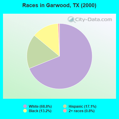
- 1,53868.8%White alone
- 38217.1%Hispanic
- 29413.2%Black alone
- 180.8%Two or more races
- 10.04%Asian alone
- 10.04%Native Hawaiian and Other
Pacific Islander alone
Races in Garwood detailed stats: ancestries, foreign born residents, place of birth
According to our research of Texas and other state lists, there were 9 registered sex offenders living in Garwood, Texas as of June 10, 2024.
The ratio of all residents to sex offenders in Garwood is 250 to 1.
 Recent articles from our blog. Our writers, many of them Ph.D. graduates or candidates, create easy-to-read articles on a wide variety of topics.
Current Local Time: CST time zone
Land area: 261.0 square miles.
Population density: 8.6 people per square mile (very low).

| Garwood CCD: | 0.7% ($341) |
| Texas: | 1.8% ($1,393) |
Nearest city with pop. 50,000+: Victoria, TX  (53.3 miles , pop. 60,603).
Nearest city with pop. 200,000+: Northwest Harris, TX (68.4 miles , pop. 405,444).
Nearest city with pop. 1,000,000+: Houston, TX (71.0 miles , pop. 1,953,631).
Nearest cities:
), ), ), Latitude: 29.46 N, Longitude: 96.51 W
Area code: 979
| Here: | 3.0% |
| Texas: | 3.5% |
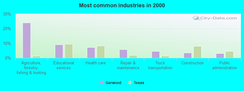
- Agriculture, forestry, fishing & hunting (24.1%)
- Educational services (9.1%)
- Health care (7.3%)
- Repair & maintenance (5.7%)
- Truck transportation (4.5%)
- Construction (3.5%)
- Public administration (3.0%)
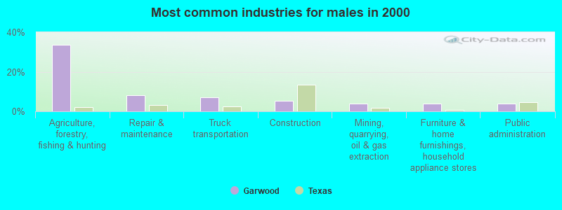
- Agriculture, forestry, fishing & hunting (33.5%)
- Repair & maintenance (8.2%)
- Truck transportation (6.9%)
- Construction (5.4%)
- Mining, quarrying, oil & gas extraction (4.0%)
- Furniture & home furnishings, household appliance stores (3.8%)
- Public administration (3.8%)
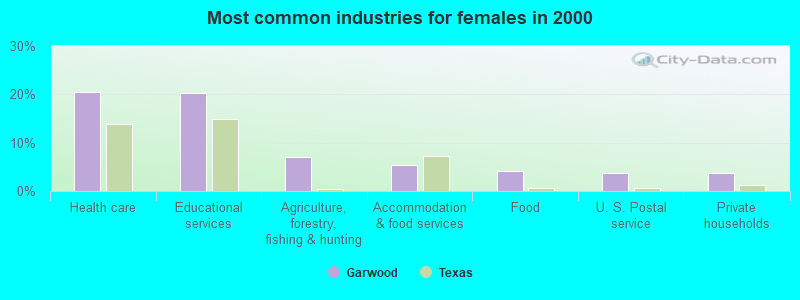
- Health care (20.5%)
- Educational services (20.2%)
- Agriculture, forestry, fishing & hunting (6.9%)
- Accommodation & food services (5.4%)
- Food (4.1%)
- U. S. Postal service (3.8%)
- Private households (3.8%)
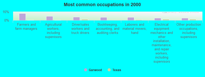
- Farmers and farm managers (13.3%)
- Agricultural workers, including supervisors (7.6%)
- Driver/sales workers and truck drivers (6.4%)
- Bookkeeping, accounting, and auditing clerks (5.8%)
- Laborers and material movers, hand (5.6%)
- Electrical equipment mechanics and other installation, maintenance, and repair workers, including supervisors (4.3%)
- Other production occupations, including supervisors (4.3%)
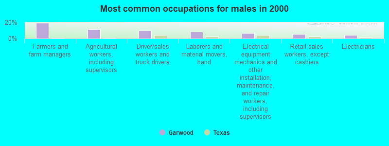
- Farmers and farm managers (19.4%)
- Agricultural workers, including supervisors (11.8%)
- Driver/sales workers and truck drivers (9.9%)
- Laborers and material movers, hand (8.7%)
- Electrical equipment mechanics and other installation, maintenance, and repair workers, including supervisors (6.6%)
- Retail sales workers, except cashiers (5.4%)
- Electricians (4.3%)
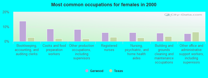
- Bookkeeping, accounting, and auditing clerks (13.9%)
- Cooks and food preparation workers (8.5%)
- Other production occupations, including supervisors (8.2%)
- Registered nurses (6.0%)
- Nursing, psychiatric, and home health aides (6.0%)
- Building and grounds cleaning and maintenance occupations (5.7%)
- Other office and administrative support workers, including supervisors (5.4%)
Average climate in Garwood, Texas
Based on data reported by over 4,000 weather stations


Tornado activity:
Garwood-area historical tornado activity is near Texas state average. It is 36% greater than the overall U.S. average.
On 3/28/1966, a category F3 (max. wind speeds 158-206 mph) tornado 11.1 miles away from the Garwood place center caused between $5000 and $50,000 in damages.
On 9/20/1967, a category F3 tornado 20.3 miles away from the place center injured 3 people and caused between $5000 and $50,000 in damages.
Earthquake activity:
Garwood-area historical earthquake activity is significantly above Texas state average. It is 34% smaller than the overall U.S. average.On 10/20/2011 at 12:24:41, a magnitude 4.8 (4.8 MW, Depth: 3.1 mi, Class: Light, Intensity: IV - V) earthquake occurred 103.2 miles away from the city center
On 4/9/1993 at 12:29:19, a magnitude 4.3 (4.1 MB, 4.3 LG, Depth: 3.1 mi) earthquake occurred 107.3 miles away from the city center
On 5/17/2012 at 08:12:00, a magnitude 4.8 (4.8 MW, Depth: 3.1 mi) earthquake occurred 212.7 miles away from Garwood center
On 5/1/2018 at 16:28:56, a magnitude 4.0 (4.0 MW, Depth: 3.1 mi) earthquake occurred 96.7 miles away from Garwood center
On 4/14/1995 at 00:32:56, a magnitude 5.7 (5.6 MB, 5.7 MS, 5.7 MW, Depth: 11.1 mi, Class: Moderate, Intensity: VI - VII) earthquake occurred 414.8 miles away from the city center
On 6/16/1978 at 11:46:54, a magnitude 5.3 (4.4 MB, 4.6 UK, 5.3 ML) earthquake occurred 352.2 miles away from the city center
Magnitude types: regional Lg-wave magnitude (LG), body-wave magnitude (MB), local magnitude (ML), surface-wave magnitude (MS), moment magnitude (MW)
Natural disasters:
The number of natural disasters in Colorado County (14) is near the US average (15).Major Disasters (Presidential) Declared: 6
Emergencies Declared: 6
Causes of natural disasters: Hurricanes: 6, Floods: 4, Storms: 4, Fires: 3, Tornadoes: 2, Wind: 1, Other: 1 (Note: some incidents may be assigned to more than one category).
Colleges/universities with over 2000 students nearest to Garwood:
- Wharton County Junior College (about 28 miles; Wharton, TX; Full-time enrollment: 5,009)
- Blinn College (about 49 miles; Brenham, TX; FT enrollment: 8,959)
- University of Houston-Victoria (about 53 miles; Victoria, TX; FT enrollment: 3,110)
- Victoria College (about 53 miles; Victoria, TX; FT enrollment: 2,730)
- Prairie View A & M University (about 54 miles; Prairie View, TX; FT enrollment: 7,517)
- Houston Baptist University (about 63 miles; Houston, TX; FT enrollment: 2,340)
- The Art Institute of Houston (about 67 miles; Houston, TX; FT enrollment: 2,429)
Points of interest:
Notable locations in Garwood: Garwood Volunteer Fire Department (A), Rock Island Volunteer Fire Department (B), Calhoun County Public Library (C), Sheridan Volunteer Fire Department (D). Display/hide their locations on the map
Church in Garwood: South Point Church (A). Display/hide its location on the map
Cemeteries: Brownson Cemetery (1), Myrtle Cemetery (2), Nada Cemetery (3), Cheetham Cemetery (4), Garwood Cemetery (5), Garwood Methodist Cemetery (6). Display/hide their locations on the map
Lakes and reservoirs: Muddy Lake (A), Heller Lake (B), Engstrom Lake Number 1 (C), Kallina Reservoir (D), Engstrom Lake Number 2 (E), Rees Reservoir (F). Display/hide their locations on the map
Streams, rivers, and creeks: West Sandy Creek (A), Urmey Branch (B), Skull Creek (C), Sand Branch (D), Marys Branch (E), Jack Branch (F), McKenzie Creek (G), East Sandy Creek (H), Dry Branch (I). Display/hide their locations on the map
| This place: | 2.5 people |
| Texas: | 2.8 people |
| This place: | 66.4% |
| Whole state: | 69.9% |
| This place: | 5.0% |
| Whole state: | 6.0% |
Likely homosexual households (counted as self-reported same-sex unmarried-partner households)
- Lesbian couples: 0.6% of all households
- Gay men: 0.2% of all households
| This place: | 22.9% |
| Whole state: | 15.4% |
| This place: | 7.8% |
| Whole state: | 6.7% |
For population 15 years and over in Garwood:
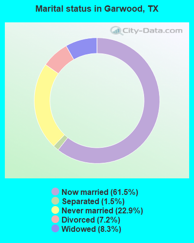
- Never married: 22.9%
- Now married: 61.5%
- Separated: 1.5%
- Widowed: 8.3%
- Divorced: 7.2%
For population 25 years and over in Garwood:
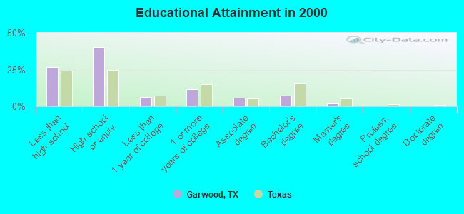
- High school or higher: 73.1%
- Bachelor's degree or higher: 9.4%
- Graduate or professional degree: 2.0%
- Unemployed: 7.3%
- Mean travel time to work (commute): 32.2 minutes
| Here: | 13.7 |
| Texas average: | 15.6 |
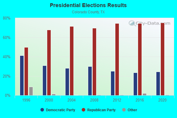
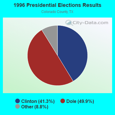
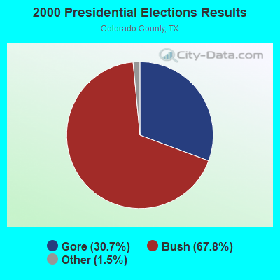

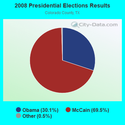
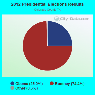
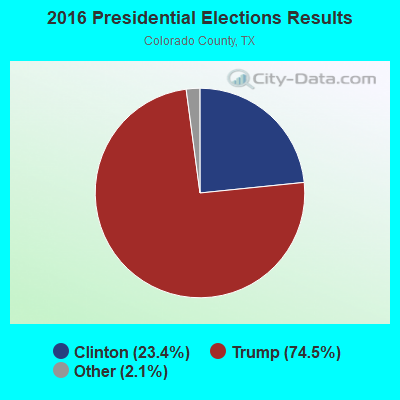
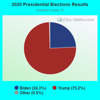
Graphs represent county-level data. Detailed 2008 Election Results
Religion statistics for Garwood, TX (based on Colorado County data)
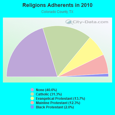
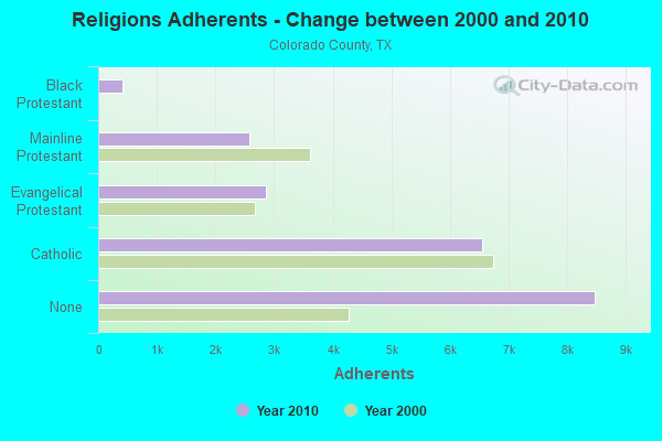
| Religion | Adherents | Congregations |
|---|---|---|
| Catholic | 6,541 | 6 |
| Evangelical Protestant | 2,862 | 23 |
| Mainline Protestant | 2,574 | 15 |
| Black Protestant | 422 | 3 |
| Other | 2 | 1 |
| None | 8,473 | - |
Food Environment Statistics:
| Here: | 2.44 / 10,000 pop. |
| Texas: | 1.47 / 10,000 pop. |
| Colorado County: | 2.93 / 10,000 pop. |
| Texas: | 1.11 / 10,000 pop. |
| Colorado County: | 9.27 / 10,000 pop. |
| Texas: | 3.95 / 10,000 pop. |
| Colorado County: | 6.34 / 10,000 pop. |
| State: | 6.13 / 10,000 pop. |
| Colorado County: | 10.8% |
| State: | 8.9% |
| Colorado County: | 28.2% |
| State: | 26.6% |
| Colorado County: | 14.6% |
| State: | 15.7% |
Strongest AM radio stations in Garwood:
- KILE (1560 AM; 50 kW; BELLAIRE, TX; Owner: THE RAFTT CORPORATION)
- KTMR (1130 AM; daytime; 10 kW; EDNA, TX; Owner: SIGA BROADCASTING CORPORATION)
- KREH (900 AM; 5 kW; PECAN GROVE, TX)
- KTRH (740 AM; 50 kW; HOUSTON, TX; Owner: AMFM TEXAS LICENSES LIMITED PARTNERSHIP)
- KGOL (1180 AM; 50 kW; HUMBLE, TX; Owner: ENTRAVISION HOLDINGS, LLC)
- KTKR (760 AM; 50 kW; SAN ANTONIO, TX; Owner: CCB TEXAS LICENSES, L.P.)
- WOAI (1200 AM; 50 kW; SAN ANTONIO, TX; Owner: CCB TEXAS LICENSES, L.P.)
- KEYH (850 AM; 10 kW; HOUSTON, TX; Owner: LIBERMAN BROADCASTING OF HOUSTON LICENSE CORP.)
- KSEV (700 AM; 15 kW; TOMBALL, TX; Owner: LIBERMAN BROADCASTING OF HOUSTON LICENSE CORP.)
- KCTA (1030 AM; 50 kW; CORPUS CHRISTI, TX; Owner: BROADCASTING CORPORATION OF THE SOUTHWEST)
- KKYX (680 AM; 50 kW; SAN ANTONIO, TX; Owner: CXR HOLDINGS, INC.)
- KRTX (980 AM; 5 kW; ROSENBURG/RICHMOND, TX)
- KKHT (1070 AM; 10 kW; HOUSTON, TX; Owner: SOUTH TEXAS BROADCASTING, INC.)
Strongest FM radio stations in Garwood:
- K216FD (91.1 FM; COLUMBUS, TX; Owner: FAMILY WORSHIP CENTER CHURCH, INC.)
- KRBE (104.1 FM; HOUSTON, TX; Owner: KRBE LICO, INC.)
- KBXX (97.9 FM; HOUSTON, TX; Owner: RADIO ONE LICENSES, LLC)
- KHJZ-FM (95.7 FM; HOUSTON, TX; Owner: TEXAS INFINITY BROADCASTING L.P.)
- KHMX (96.5 FM; HOUSTON, TX; Owner: CITICASTERS LICENSES, L.P.)
- KILT-FM (100.3 FM; HOUSTON, TX; Owner: TEXAS INFINITY BROADCASTING L.P.)
- KKBQ-FM (92.9 FM; PASADENA, TX; Owner: CXR HOLDINGS, INC.)
- KLOL (101.1 FM; HOUSTON, TX; Owner: AMFM TEXAS LICENSES LIMITED PARTNERSHIP)
- KODA (99.1 FM; HOUSTON, TX; Owner: AMFM TEXAS LICENSES LIMITED PARTNERSHIP)
- KTBZ-FM (94.5 FM; HOUSTON, TX; Owner: AMFM TEXAS LICENSES LIMITED PARTNERSHIP)
- KULM-FM (98.3 FM; COLUMBUS, TX; Owner: ROY E. HENDERSON)
- KIOX-FM (96.9 FM; EL CAMPO, TX; Owner: LIBERMAN BROADCASTING OF HOUSTON LICENSE CORP.)
- KGUL (96.1 FM; EDNA, TX; Owner: LAGRANGE BROADCASTING CORPORATION)
- KTXM (99.9 FM; HALLETTSVILLE, TX; Owner: LAGRANGE BROADCASTING CORPORATION)
TV broadcast stations around Garwood:
- KHOU-TV (Channel 11; HOUSTON, TX; Owner: KHOU-TV, L.P.)
- KPRC-TV (Channel 2; HOUSTON, TX; Owner: POST-NEWSWEEK STATIONS, HOUSTON, LP)
- KPXB (Channel 49; CONROE, TX; Owner: PAXSON HOUSTON LICENSE, INC.)
- KFTH (Channel 67; ALVIN, TX; Owner: TELEFUTURA HOUSTON LLC)
- KTBU (Channel 55; CONROE, TX; Owner: HUMANITY INTERESTED MEDIA, INC.)
- KTXH (Channel 20; HOUSTON, TX; Owner: FOX TELEVISION STATIONS, INC.)
- KNWS-TV (Channel 51; KATY, TX; Owner: JOHNSON BROADCASTING, INC.)
- KHWB (Channel 39; HOUSTON, TX; Owner: KHWB, INC.)
- KXLN-TV (Channel 45; ROSENBERG, TX; Owner: KXLN LICENSE PARTNERSHIP, L.P.)
- KRIV (Channel 26; HOUSTON, TX; Owner: FOX TELEVISION STATIONS, INC.)
- KTRK-TV (Channel 13; HOUSTON, TX; Owner: KTRK TELEVISION, INC.)
- KZJL (Channel 61; HOUSTON, TX; Owner: KZJL LICENSE CORP.)
- KETH (Channel 14; HOUSTON, TX; Owner: COMMUNITY EDUCATIONAL TV, INC.)
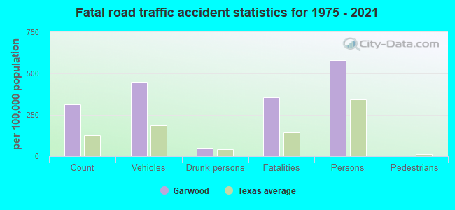
Garwood fatal accident list:
Jun 13, 1998 08:40 PM, Sr-71, Vehicles: 1, Persons: 1, Fatalities: 1, Drunk persons involved: 1
Dec 23, 1993 12:10 AM, Fm950, Vehicles: 2, Persons: 3, Fatalities: 1
Mar 18, 1991 04:15 PM, 71, Vehicles: 2, Persons: 2, Fatalities: 1
Aug 2, 1986 10:40 PM, 71, Vehicles: 1, Persons: 2, Fatalities: 1
Jun 28, 1985 06:25 AM, 71, Vehicles: 2, Persons: 2, Fatalities: 2
Jul 9, 1979 05:40 PM, Vehicles: 1, Persons: 2, Fatalities: 1
FCC Registered Antenna Towers:
39 (See the full list of FCC Registered Antenna Towers in Garwood)FCC Registered Broadcast Land Mobile Towers:
7- Hwy 71 (Lat: 29.374694 Lon: -96.445250), Call Sign: KKA544, Licensee ID: L00085300,
Assigned Frequencies: 37.4600 MHz, Grant Date: 05/17/2003, Expiration Date: 06/01/2013, Cancellation Date: 08/03/2013, Registrant: Garwood Irrigation Co, Box 428, Garwood, TX 77442
- River Pump Station 5 1/2 Mi N (Lat: 29.516083 Lon: -96.413583), Call Sign: KKM463,
Assigned Frequencies: 37.4600 MHz, Grant Date: 12/16/1998, Expiration Date: 02/28/2004, Cancellation Date: 01/23/2002, Registrant: Garwood Irrigation Co, Garwood, TX 77442
- 8 Mi Nw On Fm 1693 (Lat: 29.443306 Lon: -96.508861), Call Sign: WYL795,
Assigned Frequencies: 37.4600 MHz, Grant Date: 09/01/2004, Expiration Date: 02/28/2014, Cancellation Date: 05/03/2014, Registrant: Garwood Irrigation Co Ceo, 7836 Hwy 71, Garwood, TX 77442, Phone: (979) 758-3221, Fax: (979) 758-3844
- 1 Mi N On Hwy 71 (Lat: 29.448861 Lon: -96.405806), Call Sign: WYL796,
Assigned Frequencies: 37.4600 MHz, Grant Date: 09/02/2004, Expiration Date: 02/28/2014, Cancellation Date: 05/03/2014, Registrant: Garwood Irrigation Co Ceo, 7836 Hwy 71, Garwood, TX 77442, Phone: (979) 758-3221, Fax: (979) 758-3844
- GARWOOD, Intersection Of Main And Arthur Streets (Lat: 29.450806 Lon: -96.430806), Type: Mast, Structure height: 25 m, Overall height: 30.9 m, Call Sign: WPWG467,
Assigned Frequencies: 151.250 MHz, Grant Date: 10/07/2022, Expiration Date: 11/12/2032, Certifier: Glenn Jahn, Registrant: Colorado Cunty Oem, 305 Radio Lane Room 103, Columbus, TX 78934, Phone: (979) 733-0184, Fax: (979) 732-9635, Email:
- Lat: 29.625250 Lon: -96.460333, Call Sign: WQXF690,
Assigned Frequencies: 159.495 MHz, 159.585 MHz, 159.705 MHz, 160.035 MHz, Grant Date: 02/22/2016, Expiration Date: 02/22/2026, Certifier: Ray A Windham, Registrant: Skylines Unlimited Inc., 100 Stone Church Road, Carlisle, PA 17015, Phone: (717) 218-5003, Fax: (844) 272-2070, Email:
- Lat: 29.490250 Lon: -96.452472, Call Sign: WRFG613,
Assigned Frequencies: 151.895 MHz, Grant Date: 02/26/2020, Expiration Date: 02/26/2030, Certifier: Kwaku Buakye, Registrant: Washington Radio Reports, Gettysburg, PA 17325, Phone: (717) 334-0668, Fax: (717) 334-6440, Email:
FCC Registered Microwave Towers:
68 (See the full list of FCC Registered Microwave Towers in this town)FCC Registered Amateur Radio Licenses:
1- Call Sign: KF5KWZ, Licensee ID: L01635690, Grant Date: 04/24/2021, Expiration Date: 05/02/2031, Certifier: John F Caldwell, Registrant: John F Caldwell, Garwood, TX 77442
FAA Registered Aircraft:
30 (See the full list of FAA Registered Aircraft in Garwood)
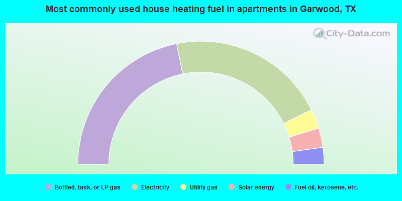
- 60.4%Bottled, tank, or LP gas
- 33.1%Electricity
- 2.3%Utility gas
- 1.4%Wood
- 1.2%Other fuel
- 0.9%No fuel used
- 0.7%Fuel oil, kerosene, etc.
- 43.7%Bottled, tank, or LP gas
- 41.8%Electricity
- 5.1%Utility gas
- 5.1%Solar energy
- 4.4%Fuel oil, kerosene, etc.
Garwood compared to Texas state average:
- Median house value below state average.
- Unemployed percentage below state average.
- Hispanic race population percentage below state average.
- Median age significantly above state average.
- Foreign-born population percentage significantly below state average.
- Renting percentage below state average.
- Length of stay since moving in significantly above state average.
- Number of rooms per house significantly below state average.
- House age significantly below state average.
- Percentage of population with a bachelor's degree or higher significantly below state average.