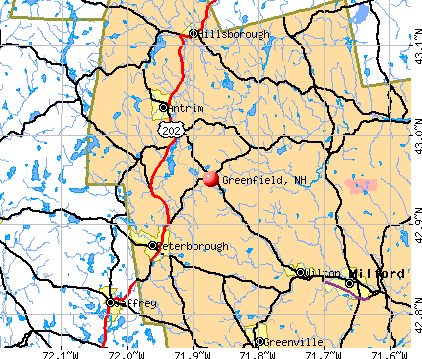
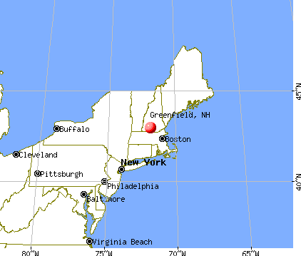
Greenfield, New Hampshire
Submit your own pictures of this town and show them to the world
- OSM Map
- General Map
- Google Map
- MSN Map
Population change since 2000: +5.6%
 |
| Males: 901 | |
| Females: 848 |
| Median resident age: | 42.3 years |
| New Hampshire median age: | 43.9 years |
Zip codes: 03047.
| Greenfield: | $88,658 |
| NH: | $89,992 |
Estimated per capita income in 2022: $39,676 (it was $19,895 in 2000)
Greenfield town income, earnings, and wages data
Estimated median house or condo value in 2022: $373,817 (it was $124,300 in 2000)
| Greenfield: | $373,817 |
| NH: | $384,700 |
Mean prices in 2022: all housing units: $411,252; detached houses: $441,251; townhouses or other attached units: $283,002; in 2-unit structures: $347,377; in 3-to-4-unit structures: $666,663; in 5-or-more-unit structures: $275,798; mobile homes: $132,093
Detailed information about poverty and poor residents in Greenfield, NH


- 1,69997.1%White alone
- 160.9%Hispanic
- 140.8%Two or more races
- 110.6%Asian alone
- 60.3%Black alone
- 30.2%American Indian alone

Races in Greenfield detailed stats: ancestries, foreign born residents, place of birth
According to our research of New Hampshire and other state lists, there were 4 registered sex offenders living in Greenfield, New Hampshire as of June 02, 2024.
The ratio of all residents to sex offenders in Greenfield is 437 to 1.
The ratio of registered sex offenders to all residents in this city is near the state average.
 Recent articles from our blog. Our writers, many of them Ph.D. graduates or candidates, create easy-to-read articles on a wide variety of topics.

 | Nicest towns in Southern NH? (19 replies) |
| Retiring in NH? (12 replies) |
| Looking at Southern NH...Where would you recommend searching? (15 replies) |
| NH: Fastest growing per-capita income in New England (25 replies) |
| Elementary school - ADHD (8 replies) |
| Pelham? (24 replies) |
Latest news from Greenfield, NH collected exclusively by city-data.com from local newspapers, TV, and radio stations
Ancestries: Irish (19.1%), English (18.9%), French (14.2%), Italian (8.4%), German (7.2%), French Canadian (6.3%).
Current Local Time: EST time zone
Incorporated in 1791
Elevation: 843 feet
Land area: 25.5 square miles.
Population density: 69 people per square mile (very low).
52 residents are foreign born (1.2% Europe, 0.7% Latin America, 0.6% North America, 0.4% Africa).
| This town: | 3.1% |
| New Hampshire: | 4.4% |
| Greenfield town: | 2.2% ($2,770) |
| New Hampshire: | 2.3% ($2,946) |
Nearest city with pop. 50,000+: Manchester, NH  (21.0 miles , pop. 107,006).
Nearest city with pop. 200,000+: Boston, MA (58.0 miles , pop. 589,141).
Nearest city with pop. 1,000,000+: Bronx, NY (177.9 miles , pop. 1,332,650).
Nearest cities:
), ), ), Latitude: 42.94 N, Longitude: 71.86 W
Area code: 603


Single-family new house construction building permits:
- 2022: 6 buildings, average cost: $308,700
- 2021: 4 buildings, average cost: $500,000
- 2020: 5 buildings, average cost: $316,000
- 2019: 4 buildings, average cost: $200,000
- 2018: 4 buildings, average cost: $200,000
- 2017: 3 buildings, average cost: $250,000
- 2016: 4 buildings, average cost: $250,000
- 2015: 6 buildings, average cost: $250,000
- 2014: 1 building, cost: $200,000
- 2013: 3 buildings, average cost: $143,300
- 2012: 5 buildings, average cost: $204,100
- 2011: 5 buildings, average cost: $120,600
- 2010: 5 buildings, average cost: $113,000
- 2009: 2 buildings, average cost: $132,500
- 2008: 2 buildings, average cost: $200,000
- 2007: 14 buildings, average cost: $237,400
- 2006: 11 buildings, average cost: $266,200
- 2005: 19 buildings, average cost: $213,200
- 2004: 14 buildings, average cost: $201,700
- 2003: 5 buildings, average cost: $152,600
- 2002: 5 buildings, average cost: $120,000
- 2001: 2 buildings, average cost: $120,700
- 2000: 11 buildings, average cost: $109,500
- 1999: 7 buildings, average cost: $92,600
- 1998: 6 buildings, average cost: $77,800
- 1997: 1 building, cost: $91,700


| Here: | 2.1% |
| New Hampshire: | 2.5% |


- Metal & metal products (9.3%)
- Health care (8.1%)
- Educational services (7.8%)
- Social assistance (7.6%)
- Construction (6.8%)
- Professional, scientific, technical services (6.3%)
- Accommodation & food services (3.3%)

- Metal & metal products (12.7%)
- Construction (12.3%)
- Professional, scientific, technical services (6.0%)
- Social assistance (4.1%)
- Repair & maintenance (3.9%)
- Machinery (3.9%)
- Health care (3.7%)

- Health care (13.6%)
- Educational services (13.4%)
- Social assistance (11.8%)
- Professional, scientific, technical services (6.8%)
- Metal & metal products (5.0%)
- Data processing, libraries, other information services (3.8%)
- Finance & insurance (3.8%)

- Metal workers and plastic workers (5.5%)
- Other office and administrative support workers, including supervisors (4.8%)
- Other management occupations, except farmers and farm managers (4.5%)
- Computer specialists (3.8%)
- Other production occupations, including supervisors (3.8%)
- Electrical equipment mechanics and other installation, maintenance, and repair workers, including supervisors (3.3%)
- Building and grounds cleaning and maintenance occupations (3.3%)

- Metal workers and plastic workers (9.4%)
- Other management occupations, except farmers and farm managers (6.2%)
- Electrical equipment mechanics and other installation, maintenance, and repair workers, including supervisors (6.0%)
- Computer specialists (4.7%)
- Driver/sales workers and truck drivers (4.7%)
- Vehicle and mobile equipment mechanics, installers, and repairers (4.5%)
- Drafters, engineering, and mapping technicians (4.5%)

- Other office and administrative support workers, including supervisors (6.5%)
- Supervisors and other personal care and service workers, except child care workers (4.8%)
- Secretaries and administrative assistants (4.8%)
- Preschool, kindergarten, elementary, and middle school teachers (4.5%)
- Registered nurses (4.0%)
- Other teachers, instructors, education, training, and library occupations (4.0%)
- Customer service representatives (3.5%)
Average climate in Greenfield, New Hampshire
Based on data reported by over 4,000 weather stations


(lower is better)

Air Quality Index (AQI) level in 2022 was 66.8. This is about average.
| City: | 66.8 |
| U.S.: | 72.6 |

Carbon Monoxide (CO) [ppm] level in 2022 was 0.133. This is significantly better than average. Closest monitor was 5.4 miles away from the city center.
| City: | 0.133 |
| U.S.: | 0.251 |

Nitrogen Dioxide (NO2) [ppb] level in 2022 was 2.05. This is significantly better than average. Closest monitor was 5.4 miles away from the city center.
| City: | 2.05 |
| U.S.: | 5.11 |

Sulfur Dioxide (SO2) [ppb] level in 2022 was 0.389. This is significantly better than average. Closest monitor was 5.4 miles away from the city center.
| City: | 0.389 |
| U.S.: | 1.515 |

Ozone [ppb] level in 2022 was 36.2. This is about average. Closest monitor was 5.4 miles away from the city center.
| City: | 36.2 |
| U.S.: | 33.3 |

Particulate Matter (PM10) [µg/m3] level in 2022 was 10.6. This is significantly better than average. Closest monitor was 5.4 miles away from the city center.
| City: | 10.6 |
| U.S.: | 19.2 |

Particulate Matter (PM2.5) [µg/m3] level in 2022 was 4.35. This is significantly better than average. Closest monitor was 5.4 miles away from the city center.
| City: | 4.35 |
| U.S.: | 8.11 |
Tornado activity:
Greenfield-area historical tornado activity is above New Hampshire state average. It is 29% smaller than the overall U.S. average.
On 6/9/1953, a category F4 (max. wind speeds 207-260 mph) tornado 36.0 miles away from the Greenfield town center killed 90 people and injured 1228 people and caused between $50,000,000 and $500,000,000 in damages.
On 6/22/1981, a category F3 (max. wind speeds 158-206 mph) tornado 26.9 miles away from the town center injured 3 people and caused between $5000 and $50,000 in damages.
Earthquake activity:
Greenfield-area historical earthquake activity is significantly above New Hampshire state average. It is 71% smaller than the overall U.S. average.On 4/20/2002 at 10:50:47, a magnitude 5.3 (5.3 ML, Depth: 3.0 mi, Class: Moderate, Intensity: VI - VII) earthquake occurred 142.4 miles away from the city center
On 10/7/1983 at 10:18:46, a magnitude 5.3 (5.1 MB, 5.3 LG, 5.1 ML) earthquake occurred 143.0 miles away from the city center
On 4/20/2002 at 10:50:47, a magnitude 5.2 (5.2 MB, 4.2 MS, 5.2 MW, 5.0 MW) earthquake occurred 141.7 miles away from the city center
On 1/19/1982 at 00:14:42, a magnitude 4.7 (4.5 MB, 4.7 MD, 4.5 LG, Class: Light, Intensity: IV - V) earthquake occurred 41.0 miles away from the city center
On 10/16/2012 at 23:12:25, a magnitude 4.7 (4.7 ML, Depth: 10.0 mi) earthquake occurred 75.9 miles away from the city center
On 10/2/1994 at 11:27:22, a magnitude 3.7 (3.5 LG, 3.7 LG, Depth: 6.2 mi, Class: Light, Intensity: II - III) earthquake occurred 46.0 miles away from Greenfield center
Magnitude types: regional Lg-wave magnitude (LG), body-wave magnitude (MB), duration magnitude (MD), local magnitude (ML), surface-wave magnitude (MS), moment magnitude (MW)
Natural disasters:
The number of natural disasters in Hillsborough County (27) is a lot greater than the US average (15).Major Disasters (Presidential) Declared: 17
Emergencies Declared: 10
Causes of natural disasters: Storms: 13, Floods: 11, Winter Storms: 5, Snowstorms: 4, Hurricanes: 3, Snows: 3, Blizzard: 1, Ice Storm: 1, Snowfall: 1, Wind: 1 (Note: some incidents may be assigned to more than one category).

Hospitals and medical centers in Greenfield:
Other hospitals and medical centers near Greenfield:
- PHEASANT WOOD CARE AND REHABILIATION CENTER (Nursing Home, about 5 miles away; PETERBOROUGH, NH)
- MONADNOCK COMMUNITY HOSPITAL Critical Access Hospitals (about 6 miles away; PETERBOROUGH, NH)
- GOOD SHEPHERD REHABILITATION AND NURSING CENTER (Nursing Home, about 12 miles away; JAFFREY, NH)
- ST JOSEPH HOME AND HOSPICE CARE (Home Health Center, about 13 miles away; MILFORD, NH)
- CRESTWOOD CARE AND REHABILITATION CENTER (Nursing Home, about 13 miles away; MILFORD, NH)
- ELM'S NURSING AND REHAB CENTER (THE) (Nursing Home, about 13 miles away; MILFORD, NH)
Heliports located in Greenfield:
Colleges/universities with over 2000 students nearest to Greenfield:
- Franklin Pierce University (about 15 miles; Rindge, NH; Full-time enrollment: 2,139)
- Saint Anselm College (about 19 miles; Manchester, NH; FT enrollment: 2,059)
- Mount Washington College (about 20 miles; Manchester, NH; FT enrollment: 2,187)
- Keene State College (about 22 miles; Keene, NH; FT enrollment: 5,098)
- Southern New Hampshire University (about 22 miles; Manchester, NH; FT enrollment: 16,552)
- Fitchburg State University (about 25 miles; Fitchburg, MA; FT enrollment: 5,010)
- Mount Wachusett Community College (about 25 miles; Gardner, MA; FT enrollment: 3,143)
Private high school in Greenfield:
Public elementary/middle school in Greenfield:
- GREENFIELD ELEMENTARY SCHOOL (Students: 102, Location: 860 FOREST RD., Grades: PK-4)
Points of interest:
Notable locations in Greenfield: Greenfield Volunteer Fire Department (A), Greenfield State Park Campground Office (B). Display/hide their locations on the map
Church in Greenfield: Union Congregational Church (A). Display/hide its location on the map
Cemetery: Greenvale Cemetery (1). Display/hide its location on the map
Lakes, reservoirs, and swamps: Hogback Pond (A), Mud Pond (B), Otter Lake (C), Sunset Lake (D), Zephyr Lake (E), Otter Brook Pond (F), Beaver Pond (G), Spruce Swamp (H). Display/hide their locations on the map
Parks in Greenfield include: Wapack National Wildlife Refuge (1), Greenfield State Park (2). Display/hide their locations on the map
Beaches: Campers Beach (A), Picnickers Beach (B). Display/hide their locations on the map
Hotel: The Greenfield Inn (749 Forest Road) (1). Display/hide its approximate location on the map
Drinking water stations with addresses in Greenfield and their reported violations in the past:
CROTCHED MOUNTAIN REHAB CENTER (Population served: 1,050, Groundwater):Past health violations:Past monitoring violations:
- MCL, Monthly (TCR) - In DEC-2011, Contaminant: Coliform. Follow-up actions: St Public Notif requested (DEC-27-2011), St Violation/Reminder Notice (DEC-27-2011), St Public Notif received (JAN-09-2012), St Compliance achieved (JUL-18-2012)
- MCL, Monthly (TCR) - In OCT-2005, Contaminant: Coliform. Follow-up actions: St Public Notif requested (OCT-21-2005), St Violation/Reminder Notice (OCT-21-2005), St Public Notif received (NOV-02-2005), St Compliance achieved (APR-30-2006)
- Monitoring and Reporting (DBP) - Between APR-01-2014 and JUL-01-2014, Contaminant: Chlorine
- Monitoring and Reporting (DBP) - Between JUL-01-2009 and OCT-01-2009, Contaminant: Total Haloacetic Acids (HAA5). Follow-up actions: St Violation/Reminder Notice (OCT-28-2009), St Compliance achieved (OCT-30-2009)
- Monitoring and Reporting (DBP) - Between JUL-01-2009 and OCT-01-2009, Contaminant: Chlorine. Follow-up actions: St Violation/Reminder Notice (OCT-28-2009), St Compliance achieved (OCT-30-2009)
- Monitoring and Reporting (DBP) - Between JUL-01-2009 and OCT-01-2009, Contaminant: TTHM. Follow-up actions: St Violation/Reminder Notice (OCT-28-2009), St Compliance achieved (OCT-30-2009)
- One routine major monitoring violation
- One minor monitoring violation
- 47 regular monitoring violations
| This town: | 2.6 people |
| New Hampshire: | 2.5 people |
| This town: | 70.6% |
| Whole state: | 66.3% |
| This town: | 10.2% |
| Whole state: | 8.3% |
Likely homosexual households (counted as self-reported same-sex unmarried-partner households)
- Lesbian couples: 0.5% of all households
- Gay men: 0.5% of all households
| This town: | 5.4% |
| Whole state: | 6.5% |
| This town: | 3.1% |
| Whole state: | 2.8% |
People in group quarters in Greenfield in 2010:
- 83 people in nursing facilities/skilled-nursing facilities
- 26 people in workers' group living quarters and job corps centers
- 25 people in group homes intended for adults
21 people in other noninstitutional group quarters in 2000
For population 15 years and over in Greenfield:

- Never married: 26.7%
- Now married: 56.4%
- Separated: 1.8%
- Widowed: 3.4%
- Divorced: 11.7%
For population 25 years and over in Greenfield:
- High school or higher: 90.9%
- Bachelor's degree or higher: 27.6%
- Graduate or professional degree: 9.0%
- Unemployed: 2.1%
- Mean travel time to work (commute): 29.5 minutes


| Here: | 9.5 |
| New Hampshire average: | 10.9 |


Graphs represent county-level data. Detailed 2008 Election Results
Religion statistics for Greenfield, NH (based on Hillsborough County data)


| Religion | Adherents | Congregations |
|---|---|---|
| Catholic | 124,993 | 40 |
| Evangelical Protestant | 20,588 | 103 |
| Mainline Protestant | 17,794 | 60 |
| Other | 7,365 | 35 |
| Orthodox | 2,990 | 7 |
| Black Protestant | - | 1 |
| None | 226,991 | - |
Food Environment Statistics:
| Hillsborough County: | 1.82 / 10,000 pop. |
| New Hampshire: | 2.14 / 10,000 pop. |
| This county: | 0.12 / 10,000 pop. |
| State: | 0.15 / 10,000 pop. |
| Hillsborough County: | 1.65 / 10,000 pop. |
| State: | 1.78 / 10,000 pop. |
| Here: | 2.67 / 10,000 pop. |
| New Hampshire: | 4.02 / 10,000 pop. |
| Here: | 8.23 / 10,000 pop. |
| New Hampshire: | 9.70 / 10,000 pop. |
| Hillsborough County: | 6.9% |
| New Hampshire: | 7.6% |
| This county: | 24.5% |
| New Hampshire: | 24.4% |
| Hillsborough County: | 15.1% |
| New Hampshire: | 15.9% |
6.73% of this county's 2021 resident taxpayers lived in other counties in 2020 ($92,767 average adjusted gross income)
| Here: | 6.73% |
| New Hampshire average: | 7.66% |
0.01% of residents moved from foreign countries ($183 average AGI)
Hillsborough County: 0.01% New Hampshire average: 0.01%
Top counties from which taxpayers relocated into this county between 2020 and 2021:
| from Middlesex County, MA | |
| from Rockingham County, NH | |
| from Merrimack County, NH |
6.49% of this county's 2020 resident taxpayers moved to other counties in 2021 ($81,100 average adjusted gross income)
| Here: | 6.49% |
| New Hampshire average: | 6.80% |
0.02% of residents moved to foreign countries ($105 average AGI)
Hillsborough County: 0.02% New Hampshire average: 0.01%
Top counties to which taxpayers relocated from this county between 2020 and 2021:
| to Rockingham County, NH | |
| to Merrimack County, NH | |
| to Middlesex County, MA |
Strongest AM radio stations in Greenfield:
- WRKO (680 AM; 50 kW; BOSTON, MA; Owner: ENTERCOM BOSTON LICENSE, LLC)
- WCRN (830 AM; 50 kW; WORCESTER, MA; Owner: CARTER BROADCASTING CORPORATION)
- WGIR (610 AM; 5 kW; MANCHESTER, NH; Owner: CAPSTAR TX LIMITED PARTNERSHIP)
- WEEI (850 AM; 50 kW; BOSTON, MA; Owner: ENTERCOM BOSTON LICENSE, LLC)
- WKOX (1200 AM; 50 kW; FRAMINGHAM, MA; Owner: CAPSTAR TX LIMITED PARTNERSHIP)
- WNNZ (640 AM; 50 kW; WESTFIELD, MA; Owner: CLEAR CHANNEL BROADCASTING LICENSES, INC.)
- WBIX (1060 AM; 40 kW; NATICK, MA; Owner: LANGER BROADCASTING CORPORATION)
- WVNE (760 AM; daytime; 25 kW; LEICESTER, MA; Owner: BLOUNT MASSCOM, INC.)
- WWZN (1510 AM; 50 kW; BOSTON, MA; Owner: ROSE CITY RADIO CORPORATION)
- WKBR (1250 AM; 5 kW; MANCHESTER, NH; Owner: DEVON BROADCASTING COMPANY, INC.)
- WBZ (1030 AM; 50 kW; BOSTON, MA; Owner: INFINITY BROADCASTING OPERATIONS, INC.)
- WALE (990 AM; 50 kW; GREENVILLE, RI; Owner: NORTH AMERICAN BROADCASTING CO., INC.)
- WAMG (890 AM; 25 kW; DEDHAM, MA; Owner: MEGA COMMUNICATIONS OF DEDHAM LICENSEE, LLC)
Strongest FM radio stations in Greenfield:
- WFEX (92.1 FM; PETERBOROUGH, NH; Owner: FNX BROADCASTING OF NEW HAMPSHIRE LLC)
- WGIR-FM (101.1 FM; MANCHESTER, NH; Owner: CAPSTAR TX LIMITED PARTNERSHIP)
- WQLL (96.5 FM; BEDFORD, NH; Owner: SAGA COMMUNICATIONS OF NEW ENGLAND, LLC)
- WLMW (90.7 FM; MANCHESTER, NH; Owner: KNOWLEDGE FOR LIFE)
- WZID (95.7 FM; MANCHESTER, NH; Owner: SAGA COMMUNICATIONS OF NEW ENGLAND, LLC)
- WTPL (107.7 FM; HILLSBORO, NH; Owner: CONCORD BROADCASTING, L.L.C.)
- WHDQ (106.1 FM; CLAREMONT, NH; Owner: GREAT NORTHERN RADIO, L.L.C.)
- WNNH (99.1 FM; HENNIKER, NH; Owner: TELE-MEDIA COMPANY OF NEW HAMPSHIRE, L.L.C.)
- WVPR (89.5 FM; WINDSOR, VT; Owner: VERMONT PUBLIC RADIO)
- WKNE (103.7 FM; KEENE, NH; Owner: SAGA COMMUNICATIONS OF NEW ENGLAND, LLC)
- WEVN (90.7 FM; KEENE, NH; Owner: NEW HAMPSHIRE PUBLIC RADIO, INC.)
- WJJR (98.1 FM; RUTLAND, VT; Owner: 6 JOHNSON ROAD LICENSES, INC.)
- WZRT (97.1 FM; RUTLAND, VT; Owner: CAPSTAR TX LIMITED PARTNERSHIP)
- WEQX (102.7 FM; MANCHESTER, VT; Owner: NORTHSHIRE COMMUNICATIONS, INC.)
- WEBK (105.3 FM; KILLINGTON, VT; Owner: 6 JOHNSON ROAD LICENSES, INC.)
- WJAN (95.1 FM; SUNDERLAND, VT; Owner: 6 JOHNSON ROAD LICENSES, INC.)
- WINQ (97.7 FM; WINCHENDON, MA; Owner: SAGA COMMUNICATIONS OF NEW ENGLAND, LLC)
- WNHI (93.3 FM; BELMONT, NH; Owner: CONCORD BROADCASTING, L.L.C.)
- WVRR (101.7 FM; NEWPORT, NH; Owner: CAPSTAR TX LIMITED PARTNERSHIP)
- WSCY (106.9 FM; MOULTONBOROUGH, NH; Owner: NORTHEAST COMMUNICATIONS CORPORATION)
TV broadcast stations around Greenfield:
- WUNI (Channel 27; WORCESTER, MA; Owner: ENTRAVISION HOLDINGS, LLC)
- WUTF (Channel 66; MARLBOROUGH, MA; Owner: TELEFUTURA BOSTON LLC)
- WMUR-TV (Channel 9; MANCHESTER, NH; Owner: HEARST-ARGYLE PROPERTIES, INC.)
- WFXZ-CA (Channel 24; BOSTON, MA; Owner: BOSTON BROADCASTING CORP.)
- WEKW-TV (Channel 52; KEENE, NH; Owner: UNIVERSITY OF NEW HAMPSHIRE)
- WNDS (Channel 50; DERRY, NH; Owner: CTV OF DERRY, INC)
- WNEU (Channel 60; MERRIMACK, NH; Owner: NBC SUBSIDIARY (NH), INC.)
Greenfield fatal accident list:
Jul 16, 2006 02:00 PM, Crotched Mountain Rd, Harry Greg Lane, Lat: 42.962300, Lon: -71.881270, Vehicles: 1, Persons: 1, Fatalities: 1
Nov 13, 2000 03:00 PM, Old Bennington Road, Vehicles: 1, Persons: 4, Fatalities: 1
Aug 10, 1993 04:55 PM, Route 31, Vehicles: 1, Persons: 2, Fatalities: 1
Sep 18, 1986 10:35 PM, 4094100000, Vehicles: 1, Persons: 1, Fatalities: 1, Drunk persons involved: 1
Dec 5, 1986 05:06 PM, 4097300000, Vehicles: 1, Persons: 2, Fatalities: 1, Drunk persons involved: 1
FCC Registered Antenna Towers:
13 (See the full list of FCC Registered Antenna Towers in Greenfield)FCC Registered Broadcast Land Mobile Towers:
2- Cmrc Admin Building (Lat: 42.971472 Lon: -71.874528), Call Sign: KYB816,
Assigned Frequencies: 152.007 MHz, Grant Date: 07/21/2015, Expiration Date: 09/10/2025, Registrant: Beltronics, Inc., 240 Main Dunstable Rd, Nashua, NH 03062-1914, Phone: (603) 402-4144, Fax: (603) 386-6344, Email:
- Lat: 42.971472 Lon: -71.874528, Call Sign: WQN893,
Assigned Frequencies: 151.895 MHz, 151.955 MHz, 151.595 MHz, 159.735 MHz, 151.910 MHz, 159.862 MHz, Grant Date: 04/21/2023, Expiration Date: 05/04/2033, Registrant: Beltronics, Inc., 240 Main Dunstable Rd, Nashua, NH 03062, Phone: (603) 402-4144, Fax: (603) 386-6433, Email:
FCC Registered Microwave Towers:
1- NH GRE CRO, Lat: 42.972139 Lon: -71.874056, Type: Tower, Structure height: 20 m, Call Sign: WQJH296,
Assigned Frequencies: 3650.00 MHz, Grant Date: 11/07/2018, Expiration Date: 10/17/2020, Cancellation Date: 12/19/2020, Certifier: Brian R Foucher, Registrant: Business Radio Licensing, 30251 Golden Lantern, Suite E # 501, Laguna Niguel, CA 92677, Phone: (949) 348-8510, Fax: (949) 348-8514, Email:
FCC Registered Amateur Radio Licenses:
15 (See the full list of FCC Registered Amateur Radio Licenses in Greenfield)FAA Registered Aircraft:
4- Aircraft: YARBERRY MANUEL CHALLENGER II (Category: Amphibian, Seats: 2, Weight: Up to 12,499 Pounds), Engine: ROTAX 503 DCDI (52 HP) (2 Cycle)
N-Number: 129AY, N129AY, N-129AY, Serial Number: CH2-0206-2719, Year manufactured: 2006, Airworthiness Date: 05/01/2007, Certificate Issue Date: 07/13/2020
Registrant (Individual): Richard E Parker, 81 Gould Hill Rd, Greenfield, NH 03047 - Aircraft: CESSNA 182A (Category: Land, Seats: 4, Weight: Up to 12,499 Pounds, Speed: 119 mph), Engine: CONT MOTOR O-470 SERIES (230 HP) (Reciprocating)
N-Number: 4942D, N4942D, N-4942D, Serial Number: 51042, Year manufactured: 1958, Certificate Issue Date: 07/06/2020
Registrant (LLC): N4942d LLC, 400 New Boston Rd, Greenfield, NH 03047 - Aircraft: CESSNA 182S (Category: Land, Seats: 6, Weight: Up to 12,499 Pounds), Engine: LYCOMING IO-540 SER (300 HP) (Reciprocating)
N-Number: 737AS, N737AS, N-737AS, Serial Number: 18280497, Year manufactured: 1999, Airworthiness Date: 05/18/1999, Certificate Issue Date: 06/13/2002
Registrant (Individual): Raymond M Trustee Cilley, 81 Muzzy Hill Rd, Greenfield, NH 03047 - Aircraft: BALLOON WORKS FIREFLY 7-15 (Category: Land, Weight: Up to 12,499 Pounds), Engine: None
N-Number: 25500, N25500, N-25500, Serial Number: F7-776, Year manufactured: 1992, Airworthiness Date: 04/02/1992, Certificate Issue Date: 05/07/1992
Registrant (Corporation): Grand Openings Inc, 70 Old Lyndeborough Mountain Rd, Greenfield, NH 03047
Deregistered: Cancel Date: 04/18/2018

- 69.1%Fuel oil, kerosene, etc.
- 17.4%Wood
- 11.3%Bottled, tank, or LP gas
- 2.2%Electricity

- 50.0%Fuel oil, kerosene, etc.
- 26.0%Bottled, tank, or LP gas
- 12.5%Electricity
- 11.5%Wood
Greenfield compared to New Hampshire state average:
- Unemployed percentage significantly below state average.
- Black race population percentage significantly below state average.
- Hispanic race population percentage significantly below state average.
- Foreign-born population percentage below state average.
- Length of stay since moving in significantly above state average.
- Number of rooms per house significantly below state average.
- House age significantly below state average.
- Institutionalized population percentage significantly above state average.
Greenfield on our top lists:
- #3 on the list of "Top 101 cities with the largest percentage of people in orthopedic wards and institutions for the physically handicapped (population 1,000+)"
- #6 on the list of "Top 101 counties with the lowest Particulate Matter (PM10) Annual air pollution readings in 2012 (µg/m3)"
- #12 on the list of "Top 101 counties with the lowest Particulate Matter (PM2.5) Annual air pollution readings in 2012 (µg/m3)"
- #15 on the list of "Top 101 counties with the lowest number of infant deaths per 1000 residents 2007-2013 (pop. 50,000+)"
- #24 on the list of "Top 101 counties with the largest decrease in the number of infant deaths per 1000 residents 2000-2006 to 2007-2013 (pop. 50,000+)"
- #44 on the list of "Top 101 counties with the lowest Nitrogen Dioxide air pollution readings in 2012 (ppm)"

|
|
Total of 14 patent applications in 2008-2024.