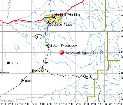
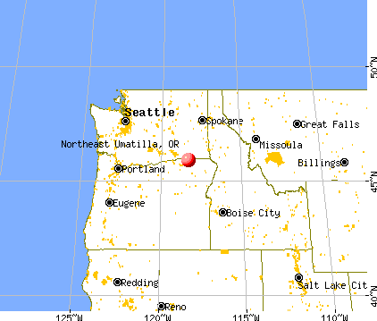
Northeast Umatilla, Oregon
Submit your own pictures of this place and show them to the world
- OSM Map
- General Map
- Google Map
- MSN Map
| Males: 5,296 | |
| Females: 5,490 |
| Median resident age: | 35.5 years |
| Oregon median age: | 36.3 years |
Zip code: 97862
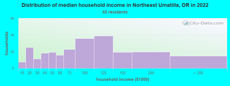
| Northeast Umatilla: | $63,695 |
| OR: | $75,657 |
Estimated per capita income in 2022: $28,091 (it was $14,233 in 2000)
Northeast Umatilla CCD income, earnings, and wages data
Estimated median house or condo value in 2022: $268,262 (it was $85,800 in 2000)
| Northeast Umatilla: | $268,262 |
| OR: | $475,600 |
Northeast Umatilla, OR residents, houses, and apartments details
Detailed information about poverty and poor residents in Northeast Umatilla, OR


- 7,70473.6%White alone
- 2,51824.1%Hispanic
- 1061.0%Two or more races
- 510.5%American Indian alone
- 400.4%Asian alone
- 220.2%Black alone
- 200.2%Other race alone
- 70.07%Native Hawaiian and Other
Pacific Islander alone
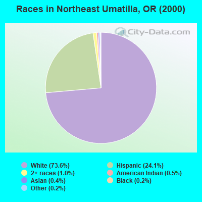
Races in Northeast Umatilla detailed stats: ancestries, foreign born residents, place of birth
 Recent articles from our blog. Our writers, many of them Ph.D. graduates or candidates, create easy-to-read articles on a wide variety of topics.
Current Local Time: PST time zone
Land area: 309.4 square miles.
Population density: 35 people per square mile (very low).
| Northeast Umatilla CCD: | 1.1% ($945) |
| Oregon: | 1.2% ($1,687) |
Nearest city with pop. 50,000+: Kennewick, WA  (46.5 miles , pop. 54,693).
Nearest city with pop. 200,000+: Portland, OR (211.5 miles , pop. 529,121).
Nearest city with pop. 1,000,000+: Los Angeles, CA (817.2 miles , pop. 3,694,820).
Nearest cities:
), )Latitude: 45.90 N, Longitude: 118.29 W
Area code commonly used in this area: 541

| Here: | 4.1% |
| Oregon: | 3.9% |
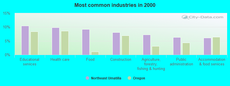
- Educational services (10.5%)
- Health care (9.8%)
- Food (9.3%)
- Construction (8.0%)
- Agriculture, forestry, fishing & hunting (7.2%)
- Public administration (6.3%)
- Accommodation & food services (6.1%)
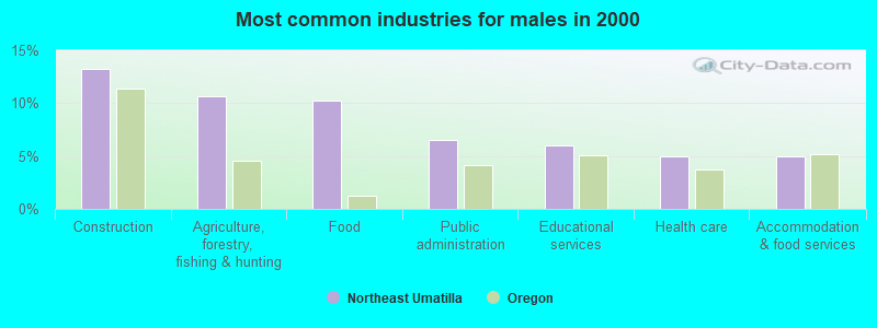
- Construction (13.3%)
- Agriculture, forestry, fishing & hunting (10.7%)
- Food (10.2%)
- Public administration (6.5%)
- Educational services (6.0%)
- Health care (5.0%)
- Accommodation & food services (4.9%)
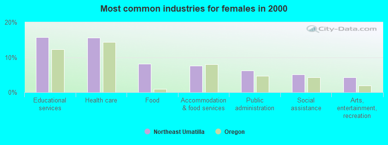
- Educational services (15.8%)
- Health care (15.6%)
- Food (8.1%)
- Accommodation & food services (7.5%)
- Public administration (6.2%)
- Social assistance (5.2%)
- Arts, entertainment, recreation (4.3%)
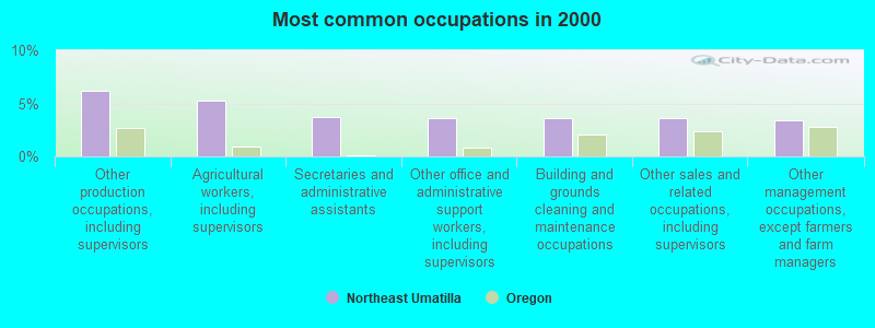
- Other production occupations, including supervisors (6.1%)
- Agricultural workers, including supervisors (5.3%)
- Secretaries and administrative assistants (3.7%)
- Other office and administrative support workers, including supervisors (3.6%)
- Building and grounds cleaning and maintenance occupations (3.6%)
- Other sales and related occupations, including supervisors (3.6%)
- Other management occupations, except farmers and farm managers (3.4%)
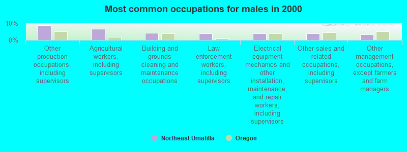
- Other production occupations, including supervisors (8.6%)
- Agricultural workers, including supervisors (6.8%)
- Building and grounds cleaning and maintenance occupations (4.3%)
- Law enforcement workers, including supervisors (4.0%)
- Electrical equipment mechanics and other installation, maintenance, and repair workers, including supervisors (3.9%)
- Other sales and related occupations, including supervisors (3.9%)
- Other management occupations, except farmers and farm managers (3.3%)
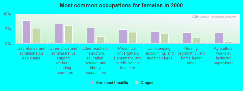
- Secretaries and administrative assistants (7.8%)
- Other office and administrative support workers, including supervisors (6.6%)
- Other teachers, instructors, education, training, and library occupations (5.4%)
- Preschool, kindergarten, elementary, and middle school teachers (4.8%)
- Bookkeeping, accounting, and auditing clerks (4.1%)
- Nursing, psychiatric, and home health aides (3.7%)
- Agricultural workers, including supervisors (3.5%)
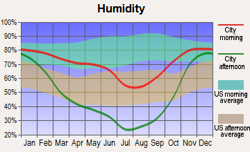
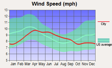
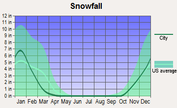
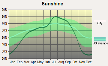
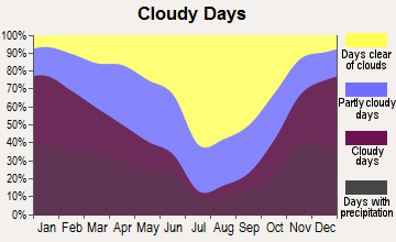
Average climate in Northeast Umatilla, Oregon
Based on data reported by over 4,000 weather stations
(lower is better)
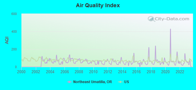
Air Quality Index (AQI) level in 2022 was 54.9. This is better than average.
| City: | 54.9 |
| U.S.: | 72.6 |
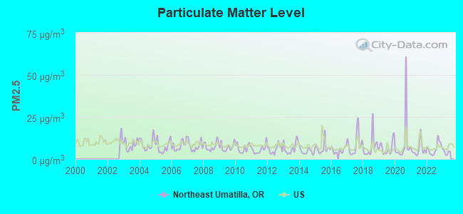
Particulate Matter (PM2.5) [µg/m3] level in 2022 was 6.35. This is better than average. Closest monitor was 11.3 miles away from the city center.
| City: | 6.35 |
| U.S.: | 8.11 |
Earthquake activity:
Northeast Umatilla-area historical earthquake activity is significantly above Oregon state average. It is 1244% greater than the overall U.S. average.On 10/28/1983 at 14:06:06, a magnitude 7.3 (6.2 MB, 7.3 MS, 7.0 MW, Class: Major, Intensity: VIII - XII) earthquake occurred 253.3 miles away from Northeast Umatilla center, causing 2 deaths (2 shaking deaths) and 3 injuries, causing $15,000,000 total damage
On 4/13/1949 at 19:55:42, a magnitude 7.0 (7.0 UK) earthquake occurred 220.6 miles away from the city center, causing $80,000,000 total damage
On 8/18/1959 at 06:37:13, a magnitude 7.7 (7.7 UK) earthquake occurred 383.2 miles away from Northeast Umatilla center, causing $26,000,000 total damage
On 10/3/1915 at 06:52:48, a magnitude 7.6 (7.6 UK) earthquake occurred 375.7 miles away from Northeast Umatilla center
On 2/28/2001 at 18:54:32, a magnitude 6.8 (6.5 MB, 6.6 MS, 6.8 MW, Class: Strong, Intensity: VII - IX) earthquake occurred 220.0 miles away from the city center, causing $2,000,000,000 total damage and $305,000,000 insured losses
On 2/28/2001 at 18:54:32, a magnitude 6.8 (6.8 MD, Depth: 32.2 mi) earthquake occurred 227.9 miles away from the city center
Magnitude types: body-wave magnitude (MB), duration magnitude (MD), surface-wave magnitude (MS), moment magnitude (MW)
Natural disasters:
The number of natural disasters in Umatilla County (10) is smaller than the US average (15).Major Disasters (Presidential) Declared: 5
Emergencies Declared: 2
Causes of natural disasters: Floods: 5, Storms: 3, Landslides: 2, Mudslides: 2, Winter Storms: 2, Drought: 1, Fire: 1, Heavy Rain: 1, Hurricane: 1, Other: 1 (Note: some incidents may be assigned to more than one category).
Hospitals and medical centers near Northeast Umatilla:
- MILTON FREEWATER HEALTH AND REHABILITATION CENTER (Nursing Home, about 6 miles away; MILTON FREEWATER, OR)
- WALLA WALLA VA MEDICAL CENTER (Hospital, Acute Care - Veterans Administration, about 10 miles away; WALLA WALLA, WA)
- PARK MANOR REHABILITATION CTR (Nursing Home, about 11 miles away; WALLA WALLA, WA)
- PROVIDENCE ST MARY HOME HEALTH (Home Health Center, about 12 miles away; WALLA WALLA, WA)
- REGENCY AT THE PARK (Nursing Home, about 12 miles away; COLLEGE PLACE, WA)
- PROVIDENCE ST MARY MEDICAL CENTER Acute Care Hospitals (about 12 miles away; WALLA WALLA, WA)
- ST MARY MEDICAL CENTER T.C.U. (Nursing Home, about 12 miles away; WALLA WALLA, WA)
Colleges/universities with over 2000 students nearest to Northeast Umatilla:
- Walla Walla Community College (about 13 miles; Walla Walla, WA; Full-time enrollment: 4,263)
- Eastern Oregon University (about 42 miles; La Grande, OR; FT enrollment: 3,127)
- Columbia Basin College (about 47 miles; Pasco, WA; FT enrollment: 5,111)
- Lewis-Clark State College (about 71 miles; Lewiston, ID; FT enrollment: 3,199)
- Washington State University (about 79 miles; Pullman, WA; FT enrollment: 25,055)
- University of Idaho (about 84 miles; Moscow, ID; FT enrollment: 10,416)
- Eastern Washington University (about 115 miles; Cheney, WA; FT enrollment: 11,643)
Points of interest:
Notable locations in Northeast Umatilla: South Fork Camp (A), Target Meadows Recreation Site (B), Tollgate Chateau (C), Blue Mountain Lutheran Bible Camp (D), Tollgate Work Center (E), Forest Camp (F), McIntyre Lookout (G), State Line (H), Demaris Cabin (I), Milton Substation (J), Davis Orchards (K), Woodward Recreation Site (L), Tollgate Work Camp (M), Tollgate Guard Station (N), Reser Cabin (O), McDougall Camp (P), Prunedale (Q), Milton - Freewater Sewage Treatment Plant (R), Barrett (S), Morning Creek Sno-Park (T). Display/hide their locations on the map
Cemeteries: Bowlus Cemetery (1), Ford Cemetery (2), Old City Cemetery (3). Display/hide their locations on the map
Reservoirs: Langdon Lake (A), Stone Hill Reservoir (B). Display/hide their locations on the map
Streams, rivers, and creeks: Woodward Creek (A), Johnson Creek (B), Elbow Creek (C), East Fork Coyote Creek (D), Skookum Creek (E), North Fork Walla Walla River (F), Couse Creek (G), Broken Creek (H), Bear Creek (I). Display/hide their locations on the map
Parks in Northeast Umatilla include: Yantis Park (1), Harris Park Recreation Site (2), Freewater Park (3). Display/hide their locations on the map
| This place: | 2.7 people |
| Oregon: | 2.5 people |
| This place: | 49.8% |
| Whole state: | 66.3% |
| This place: | 5.9% |
| Whole state: | 6.3% |
Likely homosexual households (counted as self-reported same-sex unmarried-partner households)
- Lesbian couples: 0.2% of all households
- Gay men: 0.2% of all households
| This place: | 14.5% |
| Whole state: | 11.6% |
| This place: | 5.1% |
| Whole state: | 5.0% |
People in group quarters in Northeast Umatilla in 2000:
- 141 people in agriculture workers' dormitories on farms
- 104 people in nursing homes
- 24 people in unknown juvenile institutions
- 23 people in other group homes
- 5 people in homes for the mentally retarded
For population 15 years and over in Northeast Umatilla:
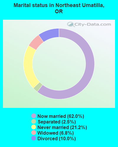
- Never married: 21.2%
- Now married: 62.0%
- Separated: 2.5%
- Widowed: 6.8%
- Divorced: 10.0%
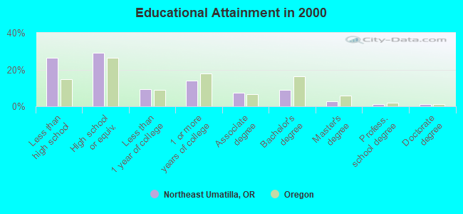
For population 25 years and over in Northeast Umatilla:
- High school or higher: 73.7%
- Bachelor's degree or higher: 14.1%
- Graduate or professional degree: 5.0%
- Unemployed: 11.1%
- Mean travel time to work (commute): 19.4 minutes
| Here: | 14.3 |
| Oregon average: | 11.5 |
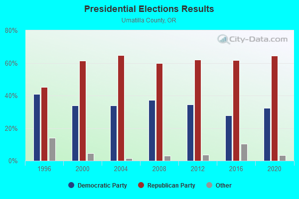
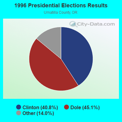

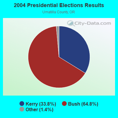
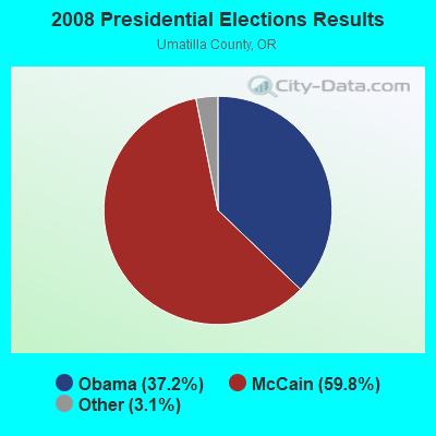

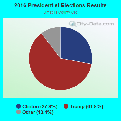
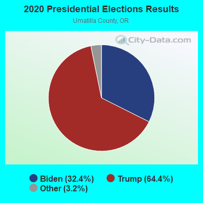
Graphs represent county-level data. Detailed 2008 Election Results
Religion statistics for Northeast Umatilla, OR (based on Umatilla County data)
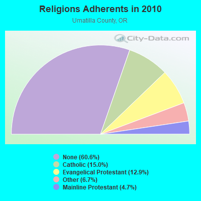
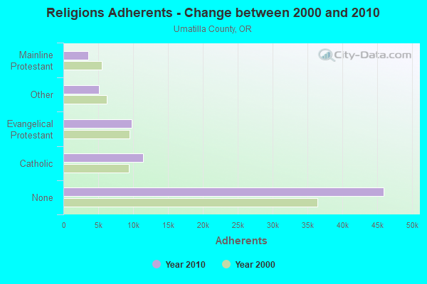
| Religion | Adherents | Congregations |
|---|---|---|
| Catholic | 11,402 | 6 |
| Evangelical Protestant | 9,816 | 75 |
| Other | 5,107 | 17 |
| Mainline Protestant | 3,575 | 24 |
| None | 45,989 | - |
Food Environment Statistics:
| Umatilla County: | 2.18 / 10,000 pop. |
| Oregon: | 2.03 / 10,000 pop. |
| Here: | 0.55 / 10,000 pop. |
| Oregon: | 0.33 / 10,000 pop. |
| Umatilla County: | 1.78 / 10,000 pop. |
| Oregon: | 2.01 / 10,000 pop. |
| Umatilla County: | 1.91 / 10,000 pop. |
| Oregon: | 1.69 / 10,000 pop. |
| Umatilla County: | 7.92 / 10,000 pop. |
| Oregon: | 9.93 / 10,000 pop. |
| This county: | 7.8% |
| State: | 7.4% |
| Umatilla County: | 32.4% |
| Oregon: | 25.6% |
| Umatilla County: | 16.9% |
| State: | 14.2% |
Strongest AM radio stations in Northeast Umatilla:
- KUJ (1420 AM; 5 kW; WALLA WALLA, WA; Owner: ALEXANDRA COMMUNICATIONS)
- KGDC (1320 AM; 1 kW; WALLA WALLA, WA; Owner: BRIDGE BROADCASTING, INC.)
- KTEL (1490 AM; 1 kW; WALLA WALLA, WA; Owner: WW2, L.L.C.)
- KUMA (1290 AM; 5 kW; PENDLETON, OR; Owner: ROUND-UP RADIO, INC.)
- KFLD (870 AM; 10 kW; PASCO, WA; Owner: CAPSTAR TX LIMITED PARTNERSHIP)
- KTBI (810 AM; daytime; 50 kW; EPHRATA, WA; Owner: TACOMA BROADCASTERS, INCORPORATED)
- KONA (610 AM; 5 kW; KENNEWICK-RICHLAND-P, WA; Owner: COMMONWEALTH LICENSE SUBSIDIARY, LLC)
- KQQQ (1150 AM; 25 kW; PULLMAN, WA; Owner: RADIO PALOUSE, INC.)
- KGA (1510 AM; 50 kW; SPOKANE, WA; Owner: CITADEL BROADCASTING COMPANY)
- KWEI (1260 AM; 50 kW; WEISER, ID; Owner: TREASURE VALLEY BROADCASTING CO.)
- KALE (960 AM; 5 kW; RICHLAND, WA; Owner: NEW NORTHWEST BROADCASTERS, LLC)
- KBOI (670 AM; 50 kW; BOISE, ID; Owner: CITADEL BROADCASTING COMPANY)
- KPOJ (620 AM; 50 kW; PORTLAND, OR; Owner: CITICASTERS LICENSES, L.P.)
Strongest FM radio stations in Northeast Umatilla:
- KRKL (93.3 FM; WALLA WALLA, WA; Owner: EDUCATIONAL MEDIA FOUNDATION)
- KNLT (95.7 FM; WALLA WALLA, WA; Owner: NEW NORTHWEST BROADCASTERS, LLC)
- KWWS (89.7 FM; WALLA WALLA, WA; Owner: WASHINGTON STATE UNIVERSITY)
- KGTS (91.3 FM; COLLEGE PLACE, WA; Owner: WALLA WALLA COLLEGE)
- KHSS (100.7 FM; WALLA WALLA, WA; Owner: TWO HEARTS COMMUNICATIONS, LLC)
- KZZM (101.9 FM; WESTON, OR; Owner: BUTTERFIELD BROADCASTING CORPORATION)
- KLRF (88.5 FM; MILTON-FREEWATER, OR; Owner: LIFETALK RADIO, INC.)
- KWHT (103.5 FM; PENDLETON, OR; Owner: KSRV, INC.)
- KOLW (97.9 FM; MILTON-FREEWATER, OR; Owner: CAPSTAR TX LIMITED PARTNERSHIP)
- KUJ-FM (99.1 FM; WALLA WALLA, WA; Owner: ALEXANDRA COMMUNICATIONS)
- KUBQ (98.7 FM; LA GRANDE, OR; Owner: GRANDE RADIO, INC.)
- KUMA-FM (107.7 FM; PENDLETON, OR; Owner: ROUND-UP RADIO, INC.)
- KZHR (92.5 FM; DAYTON, WA; Owner: COMMONWEALTH LICENSE SUBSIDIARY, LLC)
- KONA-FM (105.3 FM; KENNEWICK, WA; Owner: COMMONWEALTH LICENSE SUBSIDIARY, LLC)
- KXRX (97.1 FM; WALLA WALLA, WA; Owner: CAPSTAR TX LIMITED PARTNERSHIP)
- KEYW (98.3 FM; PASCO, WA; Owner: CAPSTAR TX LIMITED PARTNERSHIP)
- K208DB (89.5 FM; ENTERPRISE, ETC., OR; Owner: WALLOWA VALLEY TV ASSOCIATION, INC.)
- KIOK (94.9 FM; RICHLAND, WA; Owner: NEW NORTHWEST BROADCASTERS, LLC)
- K234AD (94.7 FM; ENTERPRISE, OR; Owner: WALLOWA VALLEY TV ASSOCIATION, INC.)
- K261CG (100.1 FM; PASCO, WA; Owner: NORTHWEST CHICANO RADIO NETWORK)
TV broadcast stations around Northeast Umatilla:
- K14HT (Channel 14; WALLA WALLA, ETC., WA; Owner: APPLE VALLEY BROADCASTING, INC.)
- KAZW-TV (Channel 9; WALLA WALLA, WA; Owner: CASA OF WASHINGTON, LLC)
- KFFX-TV (Channel 11; PENDLETON, OR; Owner: MOUNTAIN LICENSES, L.P.)
- K28FT (Channel 28; WALLA WALLA, WA; Owner: BLUE MOUNTAIN BROADCASTING ASSOCIATION)
- K33EJ (Channel 33; WALLA WALLA, WA; Owner: THREE ANGELS BROADCASTING NETWORK, INC.)
- K21EK (Channel 21; WALLA WALLA, WA; Owner: BLUE MOUNTAIN BROADCASTING ASSOCIATION)
- K36EW (Channel 36; COLLEGE PLACE, WA; Owner: BLUE MOUNTAIN BROADCASTING ASSOCIATION)
- K23FH (Channel 23; MILTON-FREEWATER, OR; Owner: CITIZENS T.V., INC.)
- K29EG (Channel 29; MILTON, ETC., OR; Owner: CITIZENS T.V., INC.)
- K35FO (Channel 35; MILTON-FREEWATER, OR; Owner: CITIZENS T.V., INC.)
- K40FM (Channel 40; MILTON-FREEWATER, OR; Owner: CITIZENS T.V., INC.)
- KORX-CA (Channel 16; PENDLETON, OR; Owner: WATCHTV, INC.)
- K51DF (Channel 51; MILTON, ETC., OR; Owner: CITIZENS T.V., INC.)
- K50FX (Channel 50; MILTON-FREEWATER, OR; Owner: OREGON PUBLIC BROADCASTING)
- K22BI (Channel 22; WALLA WALLA, WA; Owner: BLUE MOUNTAIN BROADCASTING ASSOCIATION)
- K46FL (Channel 46; WALLA WALLA, WA; Owner: CITIZENS T.V., INC.)
- K53EK (Channel 53; MILTON-FREEWATER, OR; Owner: CITY OF MILTON-FREEWATER)
- K55GC (Channel 55; MILTON-FREEWATER, OR; Owner: CITY OF MILTON-FREEWATER)
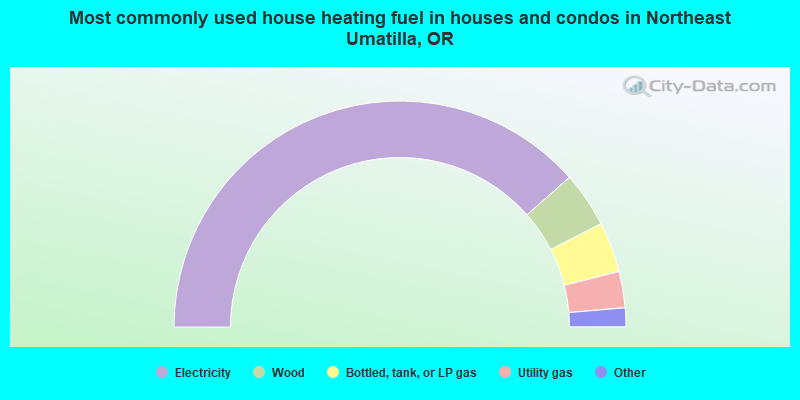
- 77.0%Electricity
- 7.9%Wood
- 7.2%Bottled, tank, or LP gas
- 5.2%Utility gas
- 1.5%Other fuel
- 1.2%Fuel oil, kerosene, etc.
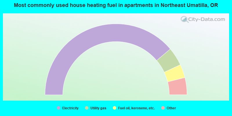
- 77.7%Electricity
- 8.4%Utility gas
- 6.1%Fuel oil, kerosene, etc.
- 3.9%Wood
- 3.3%Bottled, tank, or LP gas
- 0.6%No fuel used
Northeast Umatilla compared to Oregon state average:
- Median house value below state average.
- Black race population percentage significantly below state average.
- Foreign-born population percentage significantly below state average.
- Renting percentage significantly below state average.
- Length of stay since moving in significantly above state average.
- Number of rooms per house significantly below state average.
- House age significantly below state average.
- Institutionalized population percentage significantly above state average.
- Percentage of population with a bachelor's degree or higher below state average.
Northeast Umatilla on our top lists:
- #2 on the list of "Top 101 cities with largest percentage of males in industries: food (population 5,000+)"
- #4 on the list of "Top 101 cities with largest percentage of females in industries: food (population 5,000+)"
- #19 on the list of "Top 101 cities with largest percentage of males in occupations: nursing, psychiatric, and home health aides (population 5,000+)"
- #22 on the list of "Top 101 cities with largest percentage of males in industries: sewing, needlework, and piece goods stores (population 5,000+)"
- #27 on the list of "Top 101 cities with largest percentage of females in occupations: other teachers and instructors, education, training, and library occupations (population 5,000+)"
- #28 on the list of "Top 101 cities with largest percentage of females in occupations: agricultural workers including supervisors (population 5,000+)"
- #38 on the list of "Top 101 cities with largest percentage of males in occupations: agricultural workers including supervisors (population 5,000+)"
- #39 on the list of "Top 101 cities with largest percentage of males in occupations: food processing workers (population 5,000+)"
- #39 on the list of "Top 101 cities with largest percentage of males in occupations: registered nurses (population 5,000+)"
- #50 on the list of "Top 101 cities with largest percentage of males in industries: social assistance (population 5,000+)"
- #68 on the list of "Top 101 cities with largest percentage of females in industries: machinery (population 5,000+)"
- #71 on the list of "Top 101 cities with the largest percentage of people in agriculture workers' dormitories on farms (population 1,000+)"
- #90 on the list of "Top 101 cities with largest percentage of females in industries: building material and garden equipment and supplies dealers (population 5,000+)"
- #51 on the list of "Top 101 counties with highest percentage of residents voting for 3rd party candidates in the 2012 Presidential Election (pop. 50,000+)"