Trementina, New Mexico
Submit your own pictures of this place and show them to the world
- OSM Map
- General Map
- Google Map
- MSN Map

| Males: 116 | |
| Females: 96 |
| Median resident age: | 52.8 years |
| New Mexico median age: | 34.6 years |
Zip code: 87701
| Trementina: | $42,619 |
| NM: | $59,726 |
Estimated per capita income in 2022: $39,730 (it was $19,295 in 2000)
Trementina CCD income, earnings, and wages data
Estimated median house or condo value in 2022: $125,925 (it was $61,300 in 2000)
| Trementina: | $125,925 |
| NM: | $243,100 |
Mean prices in 2022: all housing units: $184,052; detached houses: $234,474; townhouses or other attached units: $281,942; in 3-to-4-unit structures: $216,281; mobile homes: $101,010
Detailed information about poverty and poor residents in Trementina, NM


- 15669.6%Hispanic
- 6529.0%White alone
- 20.9%Two or more races
- 10.4%American Indian alone

Races in Trementina detailed stats: ancestries, foreign born residents, place of birth
 Recent articles from our blog. Our writers, many of them Ph.D. graduates or candidates, create easy-to-read articles on a wide variety of topics.
Current Local Time: MST time zone
Elevation: 4998 feet
Land area: 1094.3 square miles.
Population density: 0.2 people per square mile (very low).

| Trementina CCD: | 0.6% ($350) |
| New Mexico: | 0.7% ($699) |
Nearest city with pop. 50,000+: Santa Fe, NM  (79.5 miles , pop. 62,203).
Nearest city with pop. 200,000+: Albuquerque, NM (117.7 miles , pop. 448,607).
Nearest city with pop. 1,000,000+: Phoenix, AZ (448.2 miles , pop. 1,321,045).
Nearest cities:
), ), )Latitude: 35.47 N, Longitude: 104.57 W
Area code: 505


| Here: | 4.0% |
| New Mexico: | 3.6% |
Average climate in Trementina, New Mexico
Based on data reported by over 4,000 weather stations


Earthquake activity:
Trementina-area historical earthquake activity is significantly above New Mexico state average. It is 543% greater than the overall U.S. average.On 8/23/2011 at 05:46:18, a magnitude 5.3 (5.3 MW, Depth: 2.5 mi, Class: Moderate, Intensity: VI - VII) earthquake occurred 110.5 miles away from the city center
On 8/10/2005 at 22:08:22, a magnitude 5.0 (5.0 MB, 4.7 MS, 5.0 MW) earthquake occurred 101.0 miles away from Trementina center
On 8/10/2005 at 22:08:22, a magnitude 5.0 (5.0 MW, Depth: 3.1 mi) earthquake occurred 103.3 miles away from Trementina center
On 8/22/2011 at 23:30:19, a magnitude 4.7 (4.7 MW, Depth: 3.1 mi, Class: Light, Intensity: IV - V) earthquake occurred 108.2 miles away from Trementina center
On 1/29/1990 at 13:16:10, a magnitude 4.8 (4.5 MB, 4.8 LG, Depth: 7.5 mi) earthquake occurred 148.1 miles away from the city center
On 9/5/2001 at 10:52:07, a magnitude 4.5 (4.5 MB, Depth: 3.1 mi) earthquake occurred 115.9 miles away from Trementina center
Magnitude types: regional Lg-wave magnitude (LG), body-wave magnitude (MB), surface-wave magnitude (MS), moment magnitude (MW)
Natural disasters:
The number of natural disasters in San Miguel County (15) is near the US average (15).Major Disasters (Presidential) Declared: 9
Emergencies Declared: 2
Causes of natural disasters: Floods: 8, Storms: 8, Fires: 5, Snows: 2, Hurricane: 1, Mudslide: 1, Other: 1 (Note: some incidents may be assigned to more than one category).
Colleges/universities with over 2000 students nearest to Trementina:
- New Mexico Highlands University (about 38 miles; Las Vegas, NM; Full-time enrollment: 2,931)
- Santa Fe Community College (about 82 miles; Santa Fe, NM; FT enrollment: 3,047)
- Eastern New Mexico University-Main Campus (about 114 miles; Portales, NM; FT enrollment: 4,263)
- University of Phoenix-Albuquerque Campus (about 116 miles; Albuquerque, NM; FT enrollment: 2,335)
- University of New Mexico-Main Campus (about 119 miles; Albuquerque, NM; FT enrollment: 23,042)
- Central New Mexico Community College (about 120 miles; Albuquerque, NM; FT enrollment: 19,398)
- Eastern New Mexico University-Roswell Campus (about 150 miles; Roswell, NM; FT enrollment: 2,212)
Points of interest:
Notable locations in Trementina: Mesteño Camp (A), Puerto Windmill (B), Quintana Ranch (C), Screw Windmill (D), Thompson Ranch (E), Maes (F), Chavez Ruins (G), Whiskey Windmill (H), Wilson Ranch (I), Simpson (J), Quintana (K), Tuloso (L), Bookout Ranch (M), Boylan Ranch (N), Brito Ranch (O), Reymond (P), Quintana (Q), Sena (R), Cabra Springs Ranch (S), Griego (T). Display/hide their locations on the map
Church in Trementina: San Rafael Church (A). Display/hide its location on the map
Cemeteries: Maes Cemetery (1), Alamosa Plaza Cemetery (2), Juan Torres Cemetery (3), Sagrado Corazon Cemetery (4), Cañon Largo Cemetery (5), Mathews Cemetery (6), Sena Cemetery (7). Display/hide their locations on the map
Lakes and reservoirs: Laguna Huerfana (A), Juan Torres Lake (B), Goetsck Lake (C), Llonidas Lake (D), Elise Tank (E), Lake Tank (F), Picket Pens Tank (G), White Tank (H). Display/hide their locations on the map
Streams, rivers, and creeks: Pino Creek (A), Cabra Creek (B), El Poso Creek (C), Lagartija Creek (D), Saladito Creek (E), Salitre Creek (F), Trementina Creek (G), Mora River (H), Corazon Creek (I). Display/hide their locations on the map
Parks in Trementina include: Canadian Escarpment Historical Marker (1), Sabinoso Wilderness Study Area (2). Display/hide their locations on the map
| This place: | 2.0 people |
| New Mexico: | 2.5 people |
| This place: | 57.4% |
| Whole state: | 65.5% |
| This place: | 4.3% |
| Whole state: | 8.2% |
No gay or lesbian households reported
| This place: | 33.8% |
| Whole state: | 18.4% |
| This place: | 12.3% |
| Whole state: | 7.8% |
For population 15 years and over in Trementina:

- Never married: 7.4%
- Now married: 63.2%
- Separated: 0.0%
- Widowed: 16.7%
- Divorced: 12.7%
For population 25 years and over in Trementina:
- High school or higher: 66.7%
- Bachelor's degree or higher: 12.6%
- Graduate or professional degree: 9.1%
- Unemployed: 8.7%
- Mean travel time to work (commute): 25.8 minutes


| Here: | 18.4 |
| New Mexico average: | 14.5 |

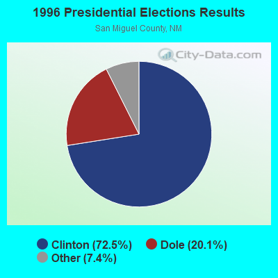
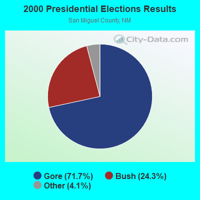
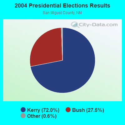
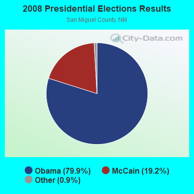
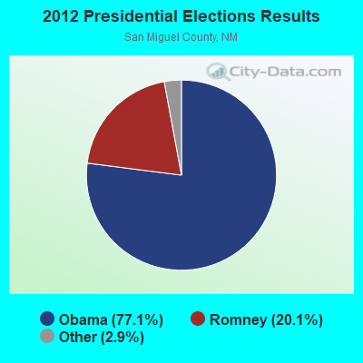
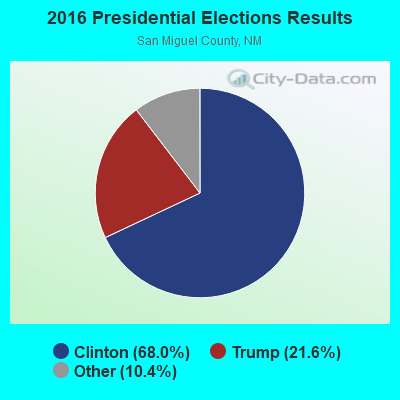
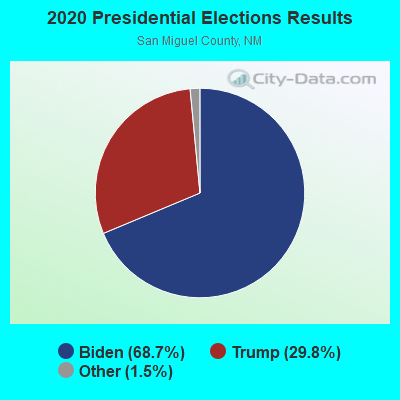
Graphs represent county-level data. Detailed 2008 Election Results
Religion statistics for Trementina, NM (based on San Miguel County data)
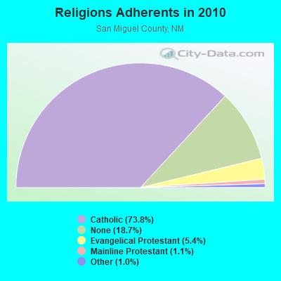
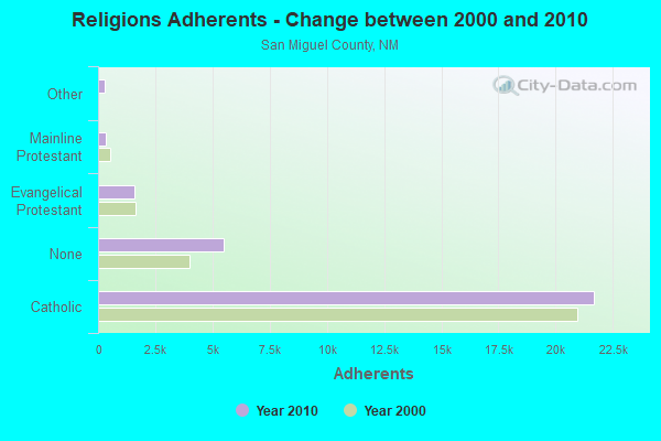
| Religion | Adherents | Congregations |
|---|---|---|
| Catholic | 21,688 | 38 |
| Evangelical Protestant | 1,590 | 21 |
| Mainline Protestant | 337 | 5 |
| Other | 284 | 3 |
| None | 5,494 | - |
Food Environment Statistics:
| San Miguel County: | 1.75 / 10,000 pop. |
| New Mexico: | 1.44 / 10,000 pop. |
| This county: | 0.35 / 10,000 pop. |
| New Mexico: | 0.21 / 10,000 pop. |
| San Miguel County: | 0.35 / 10,000 pop. |
| New Mexico: | 0.32 / 10,000 pop. |
| Here: | 4.54 / 10,000 pop. |
| New Mexico: | 4.06 / 10,000 pop. |
| San Miguel County: | 7.34 / 10,000 pop. |
| State: | 7.12 / 10,000 pop. |
| This county: | 5.6% |
| State: | 6.4% |
| This county: | 19.2% |
| New Mexico: | 22.1% |
Strongest AM radio stations in Trementina:
- KKOB (770 AM; 50 kW; ALBUQUERQUE, NM; Owner: CITADEL BROADCASTING COMPANY)
- KNMX (540 AM; 5 kW; LAS VEGAS, NM; Owner: SANGRE DE CRISTO B/DCASTING CO, INC)
- KICA (980 AM; 50 kW; CLOVIS, NM; Owner: BROADCAST ENTERTAINMENT CORPORATION)
- KMUL (1380 AM; 50 kW; MULESHOE, TX; Owner: BROADCAST ENTERTAINMENT CORPORATION)
- KINF (1020 AM; 50 kW; ROSWELL, NM; Owner: JAMES CRYSTAL HOLDINGS OF NEW MEXICO, INC.)
- KTNN (660 AM; 50 kW; WINDOW ROCK, AZ; Owner: THE NAVAJO NATION)
- KGYN (1210 AM; 50 kW; GUYMON, OK; Owner: TELNS BROADCASTING COMPANY, INC.)
- KSWV (810 AM; 5 kW; SANTA FE, NM; Owner: LA VOZ BROADCASTING CO., INC.)
- KHAC (880 AM; 43 kW; TSE BONITO, NM; Owner: WESTERN INDIAN MINISTRIES, INC.)
- KOA (850 AM; 50 kW; DENVER, CO; Owner: JACOR BROADCASTING OF COLORADO, INC.)
- KLTT (670 AM; 50 kW; COMMERCE CITY, CO; Owner: KLZ RADIO, INC.)
- KKIM (1000 AM; 10 kW; ALBUQUERQUE, NM; Owner: AGM-NEVADA, LLC)
- KIJN (1060 AM; daytime; 10 kW; FARWELL, TX; Owner: METROPOLITIAN RADIO GROUP, INC.)
Strongest FM radio stations in Trementina:
- K288EQ (105.5 FM; CONCHAS DAM, NM; Owner: CONCHAS TELEVISION ASSOCIATION)
- K202CX (88.3 FM; CONCHAS, NM; Owner: EASTERN NEW MEXICO UNIVERSITY)
- KLSK (98.1 FM; LAS VEGAS, NM; Owner: CLEAR CHANNEL BROADCASTING LICENSES, INC.)
- K215DT (90.9 FM; SAN AUGUSTIN, NM; Owner: EASTERN NEW MEXICO UNIVERSITY)
FCC Registered Maritime Coast & Aviation Ground Towers:
1- Lat: 35.516722 Lon: -104.558861, Call Sign: WQAK203,
Assigned Frequencies: 122.900 MHz, Grant Date: 06/17/2004, Expiration Date: 06/17/2009, Cancellation Date: 08/22/2009, Certifier: Jane Mcnairn, Registrant: Mile High Inc, 6400 Canoga Avenue Suite 315, Woodland Hills, CA 91367, Phone: (818) 716-1444, Fax: (811) 888-3926
FCC Registered Amateur Radio Licenses:
1- Call Sign: KJ5AIS, Licensee ID: L02651355, Grant Date: 03/24/2023, Expiration Date: 03/24/2033, Certifier: Yoav Yaron, Registrant: Yoav Yaron, 1055 County Road C56a, Trementina, NM 88439
Trementina compared to New Mexico state average:
- Median house value below state average.
- Unemployed percentage below state average.
- Black race population percentage significantly below state average.
- Median age significantly above state average.
- Foreign-born population percentage significantly below state average.
- Renting percentage below state average.
- Length of stay since moving in significantly above state average.
- Number of rooms per house significantly below state average.
- House age significantly below state average.
- Number of college students significantly below state average.
- Percentage of population with a bachelor's degree or higher below state average.
State forum archive: