Bridge Statistics for Folsom, California (CA)
Condition, Traffic, Stress, Structural Evaluation, Project Costs
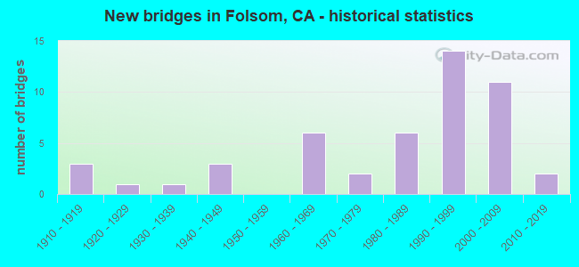
- New bridges - historical statistics
- 31910-1919
- 11920-1929
- 11930-1939
- 31940-1949
- 61960-1969
- 21970-1979
- 61980-1989
- 141990-1999
- 112000-2009
- 22010-2019

- Reconstructed bridges - Historical Statistics
- 11940-1949
- 01950-1959
- 11960-1969
- 01970-1979
- 21980-1989
- 11990-1999
- 22000-2009
- 12010-2019


- Bridge Condition - Deck
- 75.9%Good
- 3.4%Satisfactory
- 17.2%Fair
- 3.4%Poor

- Bridge Condition - Superstructure
- 76.7%Good
- 3.3%Satisfactory
- 16.7%Fair
- 3.3%Poor

- Bridge Condition - Substructure
- 93.3%Good
- 6.7%Fair

- Bridge Condition - Channel
- 27.6%Very good
- 48.3%Good
- 17.2%Satisfactory
- 6.9%Fair

- Bridge Condition - Culverts
- 87.5%Good
- 12.5%Poor
Find on map >> Show street view
Structure Number: 24 0033, Location: 03-SAC-050-16.46 (Lat: 38.636314, Lng: -121.206303), Route carried "on" structure: US 50, Year Built: 1948, Year Reconstructed: 1954, Status: Open, Structure Length: 0.74m (2.43ft), Average Daily Traffic: 115,000 (year 2009), Truck Traffic: 6%, Average Future Daily Traffic: 200,261 (year 2038), Features Intersected: ALDER CREEK
Minimum Vertical Clearance: 30+ m (98+ ft), Kilometerpoint: 16.460, Lanes on structure: 8, Base Highway Network: Yes (, Subroute: 1), Owner: State Highway Agency, Approaching Roadway Width: 22.4m (73.5ft), Skew: 33 degrees, Material/Design: Concrete continuous, Design/Construction: Culvert, Number Of Spans In Main Unit: 2, Length of Maximum Span: 3.0m (9.8ft), Curb-To-Curb Width: 22.4m (73.5ft), Out-to-Out Width: 33.5m (109.9ft)
Condition: Channel: Very good, Culverts: Good, Operating Rating: 54.1 metric tons, Method Used To Determine Operating Rating: Field evaluation and documented engineering judgment, Inventory Rating: 32.4 metric tons, Method Used To Determine Inventory Rating: Field evaluation and documented engineering judgment, Structural Evaluation: Better than present minimum criteria, Deck Geometry: High priority of replacement, Waterway Adequacy: Equal to present desirable criteria, Approach Roadway Alignment: Equal to present desirable criteria, Designated Inspection Frequency: Every 48 months, Underwater Inspection Frequency: Every 60 months, Inspection Date: October 2018, Underwater Inspection Date: September 2017
Find on map >> Show street view
Structure Number: 24 0122L, Location: 03-SAC-050-21.74 (Lat: 38.643564, Lng: -121.110378), Route carried "on" structure: US 50, Year Built: 1965, Year Reconstructed: 2005, Status: Open, Structure Length: 4.96m (16.27ft), Average Daily Traffic: 41,500 (year 2009), Truck Traffic: 7%, Average Future Daily Traffic: 73,943 (year 2038), Design Load: HS 20, Features Intersected: PLACERVILLE RD, OLD RR
Minimum Vertical Clearance: 30+ m (98+ ft), Kilometerpoint: 21.740, Lanes on structure: 5, Lanes under structure: 2, Base Highway Network: Yes (, Subroute: 1), Owner: State Highway Agency, Approaching Roadway Width: 32.3m (106.0ft), Skew: 3 degrees, Material/Design: Concrete continuous, Design/Construction: Slab, Number Of Spans In Main Unit: 4, Length of Maximum Span: 12.6m (41.3ft), Curb-To-Curb Width: 32.3m (106.0ft), Out-to-Out Width: 33.3m (109.3ft)
Condition: Deck: Good, Superstructure: Good, Substructure: Good, Operating Rating: 54.1 metric tons, Method Used To Determine Operating Rating: Assigned rating based on Load Factor Design (LFD) reported in metric tons, Inventory Rating: 32.4 metric tons, Method Used To Determine Inventory Rating: Assigned rating based on Load Factor Design (LFD) reported in metric tons, Structural Evaluation: Better than present minimum criteria, Deck Geometry: Superior to present desirable criteria, Underclear: High priority of corrective action, Approach Roadway Alignment: Equal to present desirable criteria, Designated Inspection Frequency: Every 48 months, Inspection Date: October 2020, Deck Structure Type: Concrete Cast-file-Place, Wearing Surface/Protective System: Wearing Surface: Bituminous
Find on map >> Show street view
Structure Number: 24 0122R, Location: 03-SAC-050-21.74 (Lat: 38.643261, Lng: -121.110075), Route carried "on" structure: US 50, Year Built: 1949, Year Reconstructed: 2005, Status: Open, Structure Length: 4.96m (16.27ft), Average Daily Traffic: 41,500 (year 2009), Truck Traffic: 7%, Average Future Daily Traffic: 73,943 (year 2038), Design Load: HS 20, Features Intersected: PLACERVILLE RD, OLD RR
Minimum Vertical Clearance: 30+ m (98+ ft), Kilometerpoint: 21.740, Lanes on structure: 5, Lanes under structure: 2, Base Highway Network: Yes (, Subroute: 1), Owner: State Highway Agency, Approaching Roadway Width: 28.6m (93.8ft), Skew: 3 degrees, Material/Design: Concrete continuous, Design/Construction: Slab, Number Of Spans In Main Unit: 4, Length of Maximum Span: 12.6m (41.3ft), Curb-To-Curb Width: 28.6m (93.8ft), Out-to-Out Width: 29.6m (97.1ft)
Condition: Deck: Good, Superstructure: Good, Substructure: Good, Operating Rating: 54.1 metric tons, Method Used To Determine Operating Rating: Assigned rating based on Load Factor Design (LFD) reported in metric tons, Inventory Rating: 32.4 metric tons, Method Used To Determine Inventory Rating: Assigned rating based on Load Factor Design (LFD) reported in metric tons, Structural Evaluation: Better than present minimum criteria, Deck Geometry: Superior to present desirable criteria, Underclear: High priority of corrective action, Approach Roadway Alignment: Equal to present desirable criteria, Designated Inspection Frequency: Every 48 months, Inspection Date: October 2020, Deck Structure Type: Concrete Cast-file-Place, Wearing Surface/Protective System: Wearing Surface: Bituminous
Find on map >> Show street view
Structure Number: 24 0363, Location: 03-SAC-050-21.50 (Lat: 38.643736, Lng: -121.115031), Route carried "on" structure: County highway , Year Built: 2000, Status: Open, Structure Length: 9.00m (29.53ft), Average Daily Traffic: 14,000 (year 2010), Truck Traffic: 5%, Average Future Daily Traffic: 20,919 (year 2042), Design Load: HS 20+Mod, Features Intersected: U.S. HIGHWAY 50, Facility Carried by Structure: EAST BIDWELL RD
Minimum Vertical Clearance: 30+ m (98+ ft), Kilometerpoint: 0.000, Lanes on structure: 5, Lanes under structure: 8, Base Highway Network: Yes, Owner: State Highway Agency, Approaching Roadway Width: 22.8m (74.8ft), Material/Design: Prestressed concrete continuous, Design/Construction: Box Beam or Girders - Single/Spread, Number Of Spans In Main Unit: 2, Length of Maximum Span: 45.0m (147.6ft), Curb or Sidewalk Widths: Left: 1.5m (4.9ft), Right: 1.5m (4.9ft), Curb-To-Curb Width: 22.8m (74.8ft), Out-to-Out Width: 26.5m (86.9ft)
Condition: Deck: Good, Superstructure: Fair, Substructure: Good, Operating Rating: 54.1 metric tons, Method Used To Determine Operating Rating: Assigned rating based on Load Factor Design (LFD) reported in metric tons, Inventory Rating: 32.4 metric tons, Method Used To Determine Inventory Rating: Assigned rating based on Load Factor Design (LFD) reported in metric tons, Structural Evaluation: Somewhat better than minimum adequacy, Deck Geometry: Equal to present minimum criteria, Underclear: Better than present minimum criteria, Approach Roadway Alignment: Equal to present desirable criteria, Designated Inspection Frequency: Every 24 months, Inspection Date: October 2020, Deck Structure Type: Concrete Cast-file-Place
Find on map >> Show street view
Structure Number: 24 0364S, Location: 03-SAC-050-19.20-FOL (Lat: 38.642514, Lng: -121.157192), Route carried "on" structure: Ramp US 50, Year Built: 1998, Status: Open, Structure Length: 40.92m (134.25ft), Average Daily Traffic: 8,000 (year 2010), Truck Traffic: 1%, Average Future Daily Traffic: 12,489 (year 2042), Design Load: HS 20+Mod, Features Intersected: US 50, PRAIRIE CITY RD
Minimum Vertical Clearance: 30+ m (98+ ft), Kilometerpoint: 19.200, Lanes on structure: 1, Lanes under structure: 13, Owner: State Highway Agency, Approaching Roadway Width: 8.4m (27.6ft), Material/Design: Prestressed concrete continuous, Design/Construction: Box Beam or Girders - Single/Spread, Number Of Spans In Main Unit: 8, Length of Maximum Span: 53.9m (176.8ft), Curb-To-Curb Width: 8.4m (27.6ft), Out-to-Out Width: 9.4m (30.8ft)
Condition: Deck: Good, Superstructure: Good, Substructure: Fair, Operating Rating: 54.1 metric tons, Method Used To Determine Operating Rating: Assigned rating based on Load Factor Design (LFD) reported in metric tons, Inventory Rating: 32.4 metric tons, Method Used To Determine Inventory Rating: Assigned rating based on Load Factor Design (LFD) reported in metric tons, Structural Evaluation: Somewhat better than minimum adequacy, Deck Geometry: Superior to present desirable criteria, Underclear: Equal to present minimum criteria, Approach Roadway Alignment: Equal to present desirable criteria, Designated Inspection Frequency: Every 24 months, Inspection Date: October 2020, Deck Structure Type: Concrete Cast-file-Place
Find on map >> Show street view
Structure Number: 24 0365, Location: 03-SAC-050-19.23-FOL (Lat: 38.642436, Lng: -121.156683), Route carried "on" structure: City street , Year Built: 1998, Status: Open, Structure Length: 8.10m (26.57ft), Average Daily Traffic: 2,800 (year 2010), Truck Traffic: 1%, Average Future Daily Traffic: 4,475 (year 2042), Design Load: HS 20+Mod, Features Intersected: U.S. HIGHWAY 50, Facility Carried by Structure: PRAIRIE CITY ROAD
Minimum Vertical Clearance: 30+ m (98+ ft), Kilometerpoint: 0.000, Lanes on structure: 5, Lanes under structure: 7, Owner: State Highway Agency, Approaching Roadway Width: 19.2m (63.0ft), Skew: 1 degrees, Material/Design: Prestressed concrete continuous, Design/Construction: Box Beam or Girders - Multiple, Number Of Spans In Main Unit: 2, Length of Maximum Span: 45.0m (147.6ft), Curb or Sidewalk Widths: Left: 1.5m (4.9ft), Right: 0.0m, Curb-To-Curb Width: 19.2m (63.0ft), Out-to-Out Width: 21.6m (70.9ft)
Condition: Deck: Good, Superstructure: Good, Substructure: Good, Operating Rating: 54.1 metric tons, Method Used To Determine Operating Rating: Assigned rating based on Load Factor Design (LFD) reported in metric tons, Inventory Rating: 32.4 metric tons, Method Used To Determine Inventory Rating: Assigned rating based on Load Factor Design (LFD) reported in metric tons, Structural Evaluation: Better than present minimum criteria, Deck Geometry: Meets minimum limits, Underclear: Equal to present minimum criteria, Approach Roadway Alignment: Equal to present desirable criteria, Designated Inspection Frequency: Every 24 months, Inspection Date: October 2020, Deck Structure Type: Concrete Cast-file-Place
Find on map >> Show street view
Structure Number: 24C0058, Location: 0.2 MI S/W OF U.S. 50 (Lat: 38.637481, Lng: -121.198667), Route carried "on" structure: County highway , Year Built: 1960, Status: Open, Structure Length: 0.75m (2.46ft), Average Daily Traffic: 4,545 (year 2009), Truck Traffic: 10%, Average Future Daily Traffic: 8,231 (year 2040), Features Intersected: ALDER CREEK, Facility Carried by Structure: FOLSOM BOULEVARD
Minimum Vertical Clearance: 30+ m (98+ ft), Kilometerpoint: 0.000, Lanes on structure: 6, Owner: County Highway Agency, Approaching Roadway Width: 30.5m (100.1ft), Material/Design: Concrete continuous, Design/Construction: Culvert, Number Of Spans In Main Unit: 2, Length of Maximum Span: 3.7m (12.1ft)
Condition: Channel: Good, Culverts: Good, Operating Rating: 40.5 metric tons, Method Used To Determine Operating Rating: Field evaluation and documented engineering judgment, Inventory Rating: 24.3 metric tons, Method Used To Determine Inventory Rating: Field evaluation and documented engineering judgment, Structural Evaluation: Equal to present minimum criteria, Waterway Adequacy: Superior to present desirable criteria, Approach Roadway Alignment: Equal to present desirable criteria, Designated Inspection Frequency: Every 24 months, Inspection Date: January 2021
Find on map >> Show street view
Structure Number: 24C0064, Location: 0.1 MI SE BLUE RAVINE RD (Lat: 38.669025, Lng: -121.152950), Route carried "on" structure: City street , Year Built: 1925, Year Reconstructed: 1986, Status: Open, Structure Length: 1.92m (6.30ft), Average Daily Traffic: 10,000 (year 2008), Truck Traffic: 10%, Average Future Daily Traffic: 15,903 (year 2038), Features Intersected: HUMBUG CREEK, Facility Carried by Structure: EAST BIDWELL ST
Minimum Vertical Clearance: 30+ m (98+ ft), Kilometerpoint: 0.000, Lanes on structure: 6, Owner: City or Municipal Highway Agency, Approaching Roadway Width: 24.9m (81.7ft), Skew: 20 degrees, Material/Design: Concrete continuous, Design/Construction: Slab, Number Of Spans In Main Unit: 2, Length of Maximum Span: 9.4m (30.8ft), Curb or Sidewalk Widths: Left: 1.8m (5.9ft), Right: 1.8m (5.9ft), Curb-To-Curb Width: 24.9m (81.7ft), Out-to-Out Width: 28.8m (94.5ft)
Condition: Deck: Good, Superstructure: Good, Substructure: Good, Channel: Good, Operating Rating: 26.2 metric tons, Method Used To Determine Operating Rating: Field evaluation and documented engineering judgment, Inventory Rating: 15.6 metric tons, Method Used To Determine Inventory Rating: Field evaluation and documented engineering judgment, Structural Evaluation: High priority of corrective action, Deck Geometry: Somewhat better than minimum adequacy, Waterway Adequacy: Equal to present desirable criteria, Approach Roadway Alignment: Equal to present desirable criteria, Designated Inspection Frequency: Every 24 months, Inspection Date: May 2020, Deck Structure Type: Concrete Cast-file-Place, Wearing Surface/Protective System: Wearing Surface: Bituminous
Find on map >> Show street view
Structure Number: 24C0066, Location: 0.15 MI SE CREEKSIDE DR (Lat: 38.667986, Lng: -121.147456), Route carried "on" structure: City street , Year Built: 1930, Year Reconstructed: 1986, Status: Open, Structure Length: 0.98m (3.22ft), Average Daily Traffic: 10,000 (year 2008), Truck Traffic: 10%, Average Future Daily Traffic: 15,993 (year 2038), Features Intersected: WILLOW CREEK, Facility Carried by Structure: E BIDWELL ST
Minimum Vertical Clearance: 30+ m (98+ ft), Kilometerpoint: 0.000, Lanes on structure: 5, Owner: City or Municipal Highway Agency, Approaching Roadway Width: 23.0m (75.5ft), Material/Design: Concrete, Design/Construction: Arch - Deck, Number Of Spans In Main Unit: 2, Length of Maximum Span: 9.8m (32.2ft), Curb or Sidewalk Widths: Left: 1.9m (6.2ft), Right: 2.0m (6.6ft), Curb-To-Curb Width: 31.7m (104.0ft), Out-to-Out Width: 36.3m (119.1ft)
Condition: Deck: Good, Superstructure: Fair, Substructure: Good, Channel: Good, Operating Rating: 26.2 metric tons, Method Used To Determine Operating Rating: Field evaluation and documented engineering judgment, Inventory Rating: 15.6 metric tons, Method Used To Determine Inventory Rating: Field evaluation and documented engineering judgment, Structural Evaluation: High priority of corrective action, Deck Geometry: Superior to present desirable criteria, Waterway Adequacy: Superior to present desirable criteria, Approach Roadway Alignment: Equal to present desirable criteria, Designated Inspection Frequency: Every 24 months, Inspection Date: May 2020, Deck Structure Type: Concrete Cast-file-Place, Wearing Surface/Protective System: Wearing Surface: Bituminous
Find on map >> Show street view
Structure Number: 24C0067, Location: 0.2 MI E FOLSOM-AUBURN RD (Lat: 38.681756, Lng: -121.175272), Route carried "on" structure: City street , Year Built: 1917, Year Reconstructed: 1969, Status: Open, Structure Length: 15.58m (51.12ft), Average Daily Traffic: 25,000 (year 2016), Truck Traffic: 5%, Average Future Daily Traffic: 64,857 (year 2038), Design Load: H 15, Features Intersected: AMERICAN RIVER, Facility Carried by Structure: GREENBACK LANE
Minimum Vertical Clearance: 30+ m (98+ ft), Kilometerpoint: 0.000, Lanes on structure: 2, Base Highway Network: Yes, Owner: City or Municipal Highway Agency, Approaching Roadway Width: 9.8m (32.2ft), Material/Design: Concrete, Design/Construction: Arch - Deck, Number Of Spans In Main Unit: 1, Number Of Approach Spans: 11, Length of Maximum Span: 63.4m (208.0ft), Curb or Sidewalk Widths: Left: 0.0m, Right: 1.2m (3.9ft), Curb-To-Curb Width: 7.7m (25.3ft), Out-to-Out Width: 9.5m (31.2ft)
Condition: Deck: Good, Superstructure: Good, Substructure: Good, Channel: Very good, Operating Rating: 58.0 metric tons, Method Used To Determine Operating Rating: Load Factor (LF), Inventory Rating: 35.4 metric tons, Method Used To Determine Inventory Rating: Load Factor (LF), Structural Evaluation: Better than present minimum criteria, Deck Geometry: High priority of replacement, Waterway Adequacy: Superior to present desirable criteria, Approach Roadway Alignment: Equal to present desirable criteria, Designated Inspection Frequency: Every 24 months, Inspection Date: March 2021, Deck Structure Type: Concrete Cast-file-Place, Wearing Surface/Protective System: Wearing Surface: Integral Concrete
Find on map >> Show street view
Structure Number: 24C0239, Location: 5.7 MI N LATROBE RD (Lat: 38.592936, Lng: -121.129119), Route carried "on" structure: County highway , Year Built: 1979, Status: Open, Structure Length: 1.79m (5.87ft), Average Daily Traffic: 2,265 (year 2010), Truck Traffic: 10%, Average Future Daily Traffic: 4,172 (year 2041), Design Load: HS 20+Mod, Features Intersected: COYOTE CREEK, Facility Carried by Structure: SCOTT ROAD
Minimum Vertical Clearance: 30+ m (98+ ft), Kilometerpoint: 0.000, Lanes on structure: 2, Owner: County Highway Agency, Approaching Roadway Width: 11.0m (36.1ft), Skew: 1 degrees, Material/Design: Concrete continuous, Design/Construction: Slab, Number Of Spans In Main Unit: 2, Length of Maximum Span: 8.5m (27.9ft), Curb-To-Curb Width: 11.0m (36.1ft), Out-to-Out Width: 11.6m (38.1ft)
Condition: Deck: Good, Superstructure: Good, Substructure: Good, Channel: Satisfactory, Operating Rating: 54.1 metric tons, Method Used To Determine Operating Rating: Field evaluation and documented engineering judgment, Inventory Rating: 32.4 metric tons, Method Used To Determine Inventory Rating: Field evaluation and documented engineering judgment, Structural Evaluation: Better than present minimum criteria, Deck Geometry: Somewhat better than minimum adequacy, Waterway Adequacy: Superior to present desirable criteria, Approach Roadway Alignment: Equal to present desirable criteria, Designated Inspection Frequency: Every 48 months, Inspection Date: January 2019, Deck Structure Type: Concrete Cast-file-Place, Wearing Surface/Protective System: Wearing Surface: Bituminous
Find on map >> Show street view
Structure Number: 24C026, Location: 1 MI N TWIN CITIES RD (Lat: 38.305003, Lng: -121.277172), Route carried "on" structure: County highway , Year Built: 1990, Status: Open, Structure Length: 0.98m (3.22ft), Average Daily Traffic: 244 (year 2009), Truck Traffic: 10%, Average Future Daily Traffic: 298 (year 2038), Features Intersected: SKUNK CREEK, Facility Carried by Structure: WALDO RD
Minimum Vertical Clearance: 30+ m (98+ ft), Kilometerpoint: 0.000, Lanes on structure: 2, Owner: County Highway Agency, Approaching Roadway Width: 6.1m (20.0ft), Material/Design: Steel, Design/Construction: Culvert, Number Of Spans In Main Unit: 6, Length of Maximum Span: 1.5m (4.9ft)
Condition: Channel: Fair, Culverts: Poor, Operating Rating: 54.1 metric tons, Method Used To Determine Operating Rating: Field evaluation and documented engineering judgment, Inventory Rating: 32.4 metric tons, Method Used To Determine Inventory Rating: Field evaluation and documented engineering judgment, Structural Evaluation: Meets minimum limits, Waterway Adequacy: Meets minimum limits, Approach Roadway Alignment: Equal to present desirable criteria, Length Of Structure Improvement: 0.98m (3.22ft), Designated Inspection Frequency: Every 24 months, Inspection Date: October 2020, Bridge Improvement Cost: $151,000, Roadway Improvement Cost: $30,000, Total Project Cost: $253,000 ( Estimate for 2017)
Find on map >> Show street view
Structure Number: 24C0268, Location: 0.1 MI W AMER RIVER CYN (Lat: 38.680778, Lng: -121.194047), Route carried "on" structure: City street , Year Built: 1915, Year Reconstructed: 2017, Status: Open, Structure Length: 4.94m (16.21ft), Average Daily Traffic: 1,000 (year 2008), Truck Traffic: 10%, Average Future Daily Traffic: 1,282 (year 2040), Features Intersected: GOLD CREEK, Facility Carried by Structure: ORANGEVALE AVENUE
Minimum Vertical Clearance: 30+ m (98+ ft), Kilometerpoint: 0.000, Lanes on structure: 2, Owner: City or Municipal Highway Agency, Approaching Roadway Width: 6.4m (21.0ft), Material/Design: Concrete continuous, Design/Construction: Arch - Deck, Number Of Spans In Main Unit: 1, Number Of Approach Spans: 2, Length of Maximum Span: 30.5m (100.1ft), Curb-To-Curb Width: 5.5m (18.0ft), Out-to-Out Width: 6.2m (20.3ft)
Condition: Deck: Fair, Superstructure: Fair, Substructure: Good, Channel: Fair, Operating Rating: 28.5 metric tons, Method Used To Determine Operating Rating: Field evaluation and documented engineering judgment, Inventory Rating: 17.2 metric tons, Method Used To Determine Inventory Rating: Field evaluation and documented engineering judgment, Structural Evaluation: Meets minimum limits, Deck Geometry: High priority of replacement, Waterway Adequacy: Superior to present desirable criteria, Approach Roadway Alignment: Equal to present minimum criteria, Designated Inspection Frequency: Every 24 months, Inspection Date: May 2020, Deck Structure Type: Concrete Cast-file-Place
Find on map >> Show street view
Structure Number: 24C0269, Location: WEST OF RILEY STREET (Lat: 38.676708, Lng: -121.176031), Route carried "on" structure: City street , Year Built: 1916, Status: Open, Structure Length: 2.77m (9.09ft), Average Daily Traffic: 1,000 (year 2008), Truck Traffic: 10%, Average Future Daily Traffic: 1,603 (year 2040), Features Intersected: RILEY RAVINE, Facility Carried by Structure: FIGUEROA STREET
Minimum Vertical Clearance: 30+ m (98+ ft), Kilometerpoint: 0.000, Lanes on structure: 2, Owner: City or Municipal Highway Agency, Approaching Roadway Width: 9.4m (30.8ft), Material/Design: Concrete continuous, Design/Construction: Girder and Floorbeam System, Number Of Spans In Main Unit: 3, Length of Maximum Span: 12.2m (40.0ft), Curb-To-Curb Width: 5.5m (18.0ft), Out-to-Out Width: 6.1m (20.0ft)
Condition: Deck: Fair, Superstructure: Fair, Substructure: Fair, Channel: Good, Operating Rating: 25.3 metric tons, Method Used To Determine Operating Rating: Field evaluation and documented engineering judgment, Inventory Rating: 15.2 metric tons, Method Used To Determine Inventory Rating: Field evaluation and documented engineering judgment, Structural Evaluation: Meets minimum limits, Deck Geometry: High priority of replacement, Waterway Adequacy: Superior to present desirable criteria, Approach Roadway Alignment: Equal to present desirable criteria, Designated Inspection Frequency: Every 24 months, Inspection Date: May 2020, Deck Structure Type: Concrete Cast-file-Place, Wearing Surface/Protective System: Wearing Surface: Bituminous
Find on map >> Show street view
Structure Number: 24C027, Location: 0.1 MI N BLUE RAVINE RD (Lat: 38.657044, Lng: -121.168586), Route carried "on" structure: City street , Year Built: 1986, Status: Open, Structure Length: 1.63m (5.35ft), Average Daily Traffic: 14,000 (year 2016), Truck Traffic: 10%, Average Future Daily Traffic: 6,244 (year 2042), Features Intersected: WILLOW CREEK, Facility Carried by Structure: SIBLEY STREET
Minimum Vertical Clearance: 30+ m (98+ ft), Kilometerpoint: 0.000, Lanes on structure: 5, Owner: City or Municipal Highway Agency, Approaching Roadway Width: 18.6m (61.0ft), Skew: 20 degrees, Material/Design: Concrete continuous, Design/Construction: Slab, Number Of Spans In Main Unit: 2, Length of Maximum Span: 7.7m (25.3ft), Curb or Sidewalk Widths: Left: 1.4m (4.6ft), Right: 1.4m (4.6ft), Curb-To-Curb Width: 25.9m (85.0ft), Out-to-Out Width: 29.3m (96.1ft)
Condition: Deck: Good, Superstructure: Good, Substructure: Good, Channel: Good, Operating Rating: 35.3 metric tons, Method Used To Determine Operating Rating: Load and Resistance Factor Rating (LRFR) rating reported by rating factor(RF) method using HL-93 loadings, Inventory Rating: 27.2 metric tons, Method Used To Determine Inventory Rating: Load and Resistance Factor Rating (LRFR) rating reported by rating factor(RF) method using HL-93 loadings, Structural Evaluation: Equal to present minimum criteria, Deck Geometry: Superior to present desirable criteria, Waterway Adequacy: Superior to present desirable criteria, Approach Roadway Alignment: Equal to present desirable criteria, Designated Inspection Frequency: Every 24 months, Inspection Date: May 2020, Deck Structure Type: Concrete Cast-file-Place
Find on map >> Show street view
Structure Number: 24C0329, Location: 0.1 MI S OF U.S. 50 (Lat: 38.639567, Lng: -121.155769), Route carried "on" structure: County highway , Year Built: 1967, Status: Open, Structure Length: 3.28m (10.76ft), Average Daily Traffic: 968 (year 2010), Truck Traffic: 10%, Average Future Daily Traffic: 1,094 (year 2040), Design Load: HS 20, Features Intersected: ALDER CREEK, Facility Carried by Structure: PRAIRIE CITY ROAD
Minimum Vertical Clearance: 30+ m (98+ ft), Kilometerpoint: 0.000, Lanes on structure: 2, Owner: County Highway Agency, Approaching Roadway Width: 11.0m (36.1ft), Material/Design: Concrete continuous, Design/Construction: Slab, Number Of Spans In Main Unit: 4, Length of Maximum Span: 9.1m (29.9ft), Curb-To-Curb Width: 11.0m (36.1ft), Out-to-Out Width: 11.1m (36.4ft)
Condition: Deck: Good, Superstructure: Good, Substructure: Good, Channel: Good, Operating Rating: 54.1 metric tons, Method Used To Determine Operating Rating: Load Factor (LF), Inventory Rating: 32.7 metric tons, Method Used To Determine Inventory Rating: Load Factor (LF), Structural Evaluation: Better than present minimum criteria, Deck Geometry: Better than present minimum criteria, Waterway Adequacy: Better than present minimum criteria, Approach Roadway Alignment: Equal to present desirable criteria, Designated Inspection Frequency: Every 48 months, Inspection Date: January 2019, Deck Structure Type: Concrete Cast-file-Place, Wearing Surface/Protective System: Wearing Surface: Bituminous
Find on map >> Show street view
Structure Number: 24C038, Location: 0.18 MI W ELK GR FLORIN R (Lat: 38.423414, Lng: -121.375003), Route carried "on" structure: County highway , Year Built: 1973, Year Reconstructed: 1996, Status: Open, Structure Length: 4.53m (14.86ft), Average Daily Traffic: 34,800 (year 2014), Truck Traffic: 6%, Average Future Daily Traffic: 54,875 (year 2037), Design Load: HS 20+Mod, Features Intersected: LAGUNA CREEK, Facility Carried by Structure: BOND ROAD
Minimum Vertical Clearance: 30+ m (98+ ft), Kilometerpoint: 0.000, Lanes on structure: 5, Base Highway Network: Yes, Owner: City or Municipal Highway Agency, Approaching Roadway Width: 20.7m (67.9ft), Skew: 2 degrees, Material/Design: Concrete continuous, Design/Construction: Slab, Number Of Spans In Main Unit: 5, Length of Maximum Span: 9.8m (32.2ft), Curb or Sidewalk Widths: Left: 3.6m (11.8ft), Right: 1.5m (4.9ft), Curb-To-Curb Width: 20.7m (67.9ft), Out-to-Out Width: 27.1m (88.9ft)
Condition: Deck: Good, Superstructure: Good, Substructure: Good, Channel: Satisfactory, Operating Rating: 54.1 metric tons, Method Used To Determine Operating Rating: Assigned rating based on Load Factor Design (LFD) reported in metric tons, Inventory Rating: 32.4 metric tons, Method Used To Determine Inventory Rating: Assigned rating based on Load Factor Design (LFD) reported in metric tons, Structural Evaluation: Better than present minimum criteria, Deck Geometry: Somewhat better than minimum adequacy, Waterway Adequacy: Superior to present desirable criteria, Approach Roadway Alignment: Equal to present desirable criteria, Designated Inspection Frequency: Every 48 months, Inspection Date: May 2019, Deck Structure Type: Concrete Cast-file-Place, Wearing Surface/Protective System: Wearing Surface: Bituminous
Find on map >> Show street view
Structure Number: 24C0384, Location: 0.6 MI S OF E BIDWELL RD (Lat: 38.660567, Lng: -121.157736), Route carried "on" structure: City street , Year Built: 1986, Status: Open, Structure Length: 1.65m (5.41ft), Average Daily Traffic: 18,500 (year 2016), Truck Traffic: 10%, Average Future Daily Traffic: 10,903 (year 2036), Features Intersected: WILLOW CREEK, Facility Carried by Structure: BLUE RAVINE ROAD
Minimum Vertical Clearance: 30+ m (98+ ft), Kilometerpoint: 0.000, Lanes on structure: 5, Owner: City or Municipal Highway Agency, Approaching Roadway Width: 31.1m (102.0ft), Skew: 3 degrees, Material/Design: Concrete continuous, Design/Construction: Slab, Number Of Spans In Main Unit: 2, Length of Maximum Span: 8.2m (26.9ft), Curb or Sidewalk Widths: Left: 1.0m (3.3ft), Right: 1.0m (3.3ft), Curb-To-Curb Width: 32.0m (105.0ft), Out-to-Out Width: 33.5m (109.9ft)
Condition: Deck: Good, Superstructure: Good, Substructure: Good, Channel: Good, Operating Rating: 99.8 metric tons, Method Used To Determine Operating Rating: Load Factor (LF), Inventory Rating: 61.6 metric tons, Method Used To Determine Inventory Rating: Load Factor (LF), Structural Evaluation: Better than present minimum criteria, Deck Geometry: Superior to present desirable criteria, Waterway Adequacy: Superior to present desirable criteria, Approach Roadway Alignment: Equal to present minimum criteria, Designated Inspection Frequency: Every 48 months, Inspection Date: May 2018, Deck Structure Type: Concrete Cast-file-Place
Find on map >> Show street view
Structure Number: 24C0386, Location: 0.5 MI S. OF BLUE RAVINE (Lat: 38.670297, Lng: -121.134786), Route carried "on" structure: City street , Year Built: 1988, Status: Open, Structure Length: 1.28m (4.20ft), Average Daily Traffic: 15,842 (year 2007), Truck Traffic: 10%, Average Future Daily Traffic: 11,132 (year 2039), Features Intersected: WILLOW CREEK, Facility Carried by Structure: OAK AVENUE PARKWAY
Minimum Vertical Clearance: 30+ m (98+ ft), Kilometerpoint: 0.000, Lanes on structure: 6, Owner: City or Municipal Highway Agency, Approaching Roadway Width: 26.2m (86.0ft), Skew: 30 degrees, Material/Design: Concrete continuous, Design/Construction: Culvert, Number Of Spans In Main Unit: 4, Length of Maximum Span: 3.0m (9.8ft), Curb or Sidewalk Widths: Left: 1.3m (4.3ft), Right: 1.3m (4.3ft), Curb-To-Curb Width: 26.3m (86.3ft), Out-to-Out Width: 33.9m (111.2ft)
Condition: Channel: Satisfactory, Culverts: Good, Operating Rating: 54.1 metric tons, Method Used To Determine Operating Rating: Field evaluation and documented engineering judgment, Inventory Rating: 32.4 metric tons, Method Used To Determine Inventory Rating: Field evaluation and documented engineering judgment, Structural Evaluation: Better than present minimum criteria, Deck Geometry: Equal to present minimum criteria, Waterway Adequacy: Equal to present desirable criteria, Approach Roadway Alignment: Equal to present desirable criteria, Designated Inspection Frequency: Every 48 months, Inspection Date: May 2018, Deck Structure Type: Concrete Cast-file-Place, Wearing Surface/Protective System: Wearing Surface: Bituminous
Find on map >> Show street view
Structure Number: 24C0387, Location: 200' S. OF BLUE RAVINE RD (Lat: 38.675364, Lng: -121.136319), Route carried "on" structure: City street , Year Built: 1988, Status: Open, Structure Length: 1.28m (4.20ft), Average Daily Traffic: 14,097 (year 2007), Truck Traffic: 10%, Average Future Daily Traffic: 10,832 (year 2036), Features Intersected: HUMBUG CREEK, Facility Carried by Structure: OAK AVENUE PARKWAY
Minimum Vertical Clearance: 30+ m (98+ ft), Kilometerpoint: 0.000, Lanes on structure: 6, Owner: City or Municipal Highway Agency, Approaching Roadway Width: 25.6m (84.0ft), Skew: 20 degrees, Material/Design: Concrete continuous, Design/Construction: Culvert, Number Of Spans In Main Unit: 4, Length of Maximum Span: 3.0m (9.8ft), Curb-To-Curb Width: 33.5m (109.9ft), Out-to-Out Width: 34.1m (111.9ft)
Condition: Channel: Satisfactory, Culverts: Good, Operating Rating: 54.1 metric tons, Method Used To Determine Operating Rating: Field evaluation and documented engineering judgment, Inventory Rating: 32.4 metric tons, Method Used To Determine Inventory Rating: Field evaluation and documented engineering judgment, Structural Evaluation: Better than present minimum criteria, Deck Geometry: Superior to present desirable criteria, Waterway Adequacy: Equal to present desirable criteria, Approach Roadway Alignment: Equal to present desirable criteria, Designated Inspection Frequency: Every 48 months, Inspection Date: May 2018
Find on map >> Show street view
Structure Number: 24C0401, Location: 0.85 MI N ELVERTA RD (Lat: 38.726239, Lng: -121.469858), Route carried "on" structure: County highway , Year Built: 1963, Status: Open, Structure Length: 1.19m (3.90ft), Average Daily Traffic: 6,300 (year 2018), Truck Traffic: 5%, Average Future Daily Traffic: 7,918 (year 2044), Design Load: HS 20, Features Intersected: NATOMAS E TRIBUTARY NO1, Facility Carried by Structure: RIO LINDA BLVD
Minimum Vertical Clearance: 30+ m (98+ ft), Kilometerpoint: 0.000, Lanes on structure: 2, Owner: County Highway Agency, Approaching Roadway Width: 7.3m (24.0ft), Skew: 1 degrees, Material/Design: Concrete continuous, Design/Construction: Slab, Number Of Spans In Main Unit: 2, Length of Maximum Span: 5.5m (18.0ft), Curb or Sidewalk Widths: Left: 1.5m (4.9ft), Right: 0.0m, Curb-To-Curb Width: 19.0m (62.3ft), Out-to-Out Width: 21.1m (69.2ft)
Condition: Deck: Good, Superstructure: Good, Substructure: Good, Channel: Good, Operating Rating: 54.1 metric tons, Method Used To Determine Operating Rating: Field evaluation and documented engineering judgment, Inventory Rating: 32.4 metric tons, Method Used To Determine Inventory Rating: Field evaluation and documented engineering judgment, Structural Evaluation: Better than present minimum criteria, Deck Geometry: Superior to present desirable criteria, Waterway Adequacy: Meets minimum limits, Approach Roadway Alignment: Equal to present desirable criteria, Designated Inspection Frequency: Every 48 months, Inspection Date: January 2022, Deck Structure Type: Concrete Cast-file-Place, Wearing Surface/Protective System: Wearing Surface: Bituminous
Find on map >> Show street view
Structure Number: 24C0409, Location: 0.1 MI W FOLSOM BLVD (Lat: 38.653572, Lng: -121.183578), Route carried "on" structure: City street , Year Built: 1984, Status: Open, Structure Length: 2.50m (8.20ft), Average Daily Traffic: 11,000 (year 2016), Truck Traffic: 2%, Average Future Daily Traffic: 15,000 (year 2037), Design Load: HS 20+Mod, Features Intersected: WILLOW CREEK, Facility Carried by Structure: BLUE RAVINE ROAD
Minimum Vertical Clearance: 30+ m (98+ ft), Kilometerpoint: 0.000, Lanes on structure: 2, Owner: City or Municipal Highway Agency, Approaching Roadway Width: 9.1m (29.9ft), Material/Design: Concrete continuous, Design/Construction: Slab, Number Of Spans In Main Unit: 3, Length of Maximum Span: 8.5m (27.9ft), Curb or Sidewalk Widths: Left: 1.5m (4.9ft), Right: 0.0m, Curb-To-Curb Width: 9.1m (29.9ft), Out-to-Out Width: 10.9m (35.8ft)
Condition: Deck: Good, Superstructure: Good, Substructure: Good, Channel: Good, Operating Rating: 54.1 metric tons, Method Used To Determine Operating Rating: Field evaluation and documented engineering judgment, Inventory Rating: 32.4 metric tons, Method Used To Determine Inventory Rating: Field evaluation and documented engineering judgment, Structural Evaluation: Better than present minimum criteria, Deck Geometry: High priority of corrective action, Waterway Adequacy: Better than present minimum criteria, Approach Roadway Alignment: Equal to present desirable criteria, Designated Inspection Frequency: Every 48 months, Inspection Date: May 2020, Deck Structure Type: Concrete Cast-file-Place, Wearing Surface/Protective System: Wearing Surface: Bituminous
Find on map >> Show street view
Structure Number: 24C0501, Location: 0.25 MI W OF FRANKLIN BL (Lat: 38.408619, Lng: -121.455100), Route carried "on" structure: County highway , Year Built: 2002, Status: Open, Structure Length: 6.25m (20.51ft), Average Daily Traffic: 10,100 (year 2009), Truck Traffic: 5%, Average Future Daily Traffic: 14,772 (year 2042), Design Load: HS 20+Mod, Features Intersected: UP RR AND BNSF RY, Facility Carried by Structure: ELK GROVE BLVD
Minimum Vertical Clearance: 30+ m (98+ ft), Kilometerpoint: 0.000, Lanes on structure: 5, Base Highway Network: Yes, Owner: City or Municipal Highway Agency, Approaching Roadway Width: 26.8m (87.9ft), Skew: 30 degrees, Material/Design: Prestressed concrete continuous, Design/Construction: Box Beam or Girders - Multiple, Number Of Spans In Main Unit: 2, Length of Maximum Span: 32.1m (105.3ft), Curb or Sidewalk Widths: Left: 1.7m (5.6ft), Right: 0.0m, Curb-To-Curb Width: 23.7m (77.8ft), Out-to-Out Width: 26.8m (87.9ft)
Condition: Deck: Fair, Superstructure: Good, Substructure: Good, Operating Rating: 54.1 metric tons, Method Used To Determine Operating Rating: Field evaluation and documented engineering judgment, Inventory Rating: 32.4 metric tons, Method Used To Determine Inventory Rating: Field evaluation and documented engineering judgment, Structural Evaluation: Better than present minimum criteria, Deck Geometry: Better than present minimum criteria, Underclear: Equal to present desirable criteria, Approach Roadway Alignment: Equal to present desirable criteria, Designated Inspection Frequency: Every 24 months, Inspection Date: October 2020, Deck Structure Type: Concrete Cast-file-Place
Find on map >> Show street view
Structure Number: 24C0504, Location: 0.3 MI SOUTH OF GREENBACK (Lat: 38.677944, Lng: -121.180608), Route carried "on" structure: City street , Year Built: 1999, Status: Open, Structure Length: 69.06m (226.57ft), Average Daily Traffic: 25,000 (year 2016), Truck Traffic: 7%, Average Future Daily Traffic: 29,141 (year 2042), Design Load: HS 20+Mod, Features Intersected: AMERICAN RIVER LK NATOMA, Facility Carried by Structure: FOLSOM -AUBURN BL
Minimum Vertical Clearance: 30+ m (98+ ft), Kilometerpoint: 0.000, Lanes on structure: 4, Owner: City or Municipal Highway Agency, Approaching Roadway Width: 27.7m (90.9ft), Skew: 30 degrees, Material/Design: Prestressed concrete continuous, Design/Construction: Box Beam or Girders - Single/Spread, Number Of Spans In Main Unit: 5, Number Of Approach Spans: 5, Length of Maximum Span: 100.0m (328.1ft), Curb or Sidewalk Widths: Left: 2.4m (7.9ft), Right: 2.4m (7.9ft), Curb-To-Curb Width: 27.7m (90.9ft), Out-to-Out Width: 33.9m (111.2ft)
Condition: Deck: Fair, Superstructure: Good, Substructure: Good, Channel: Very good, Operating Rating: 54.1 metric tons, Method Used To Determine Operating Rating: Assigned rating based on Load Factor Design (LFD) reported in metric tons, Inventory Rating: 32.4 metric tons, Method Used To Determine Inventory Rating: Assigned rating based on Load Factor Design (LFD) reported in metric tons, Structural Evaluation: Better than present minimum criteria, Deck Geometry: Superior to present desirable criteria, Waterway Adequacy: Equal to present minimum criteria, Approach Roadway Alignment: Equal to present desirable criteria, Designated Inspection Frequency: Every 24 months, Underwater Inspection Frequency: Every 60 months, Inspection Date: May 2020, Underwater Inspection Date: September 2017, Deck Structure Type: Concrete Cast-file-Place
Find on map >> Show street view
Structure Number: 24C0505, Location: 0.6 MI SW OF GOLD LAKE RD (Lat: 38.675789, Lng: -121.181061), Route carried "on" structure: City street , Year Built: 1998, Status: Open, Structure Length: 3.22m (10.56ft), Average Daily Traffic: 762 (year 2016), Truck Traffic: 4%, Average Future Daily Traffic: 1,092 (year 2042), Design Load: HS 20, Features Intersected: FOLSOM BLVD, Facility Carried by Structure: LEIDESDORFF ST,LRT
Minimum Vertical Clearance: 30+ m (98+ ft), Kilometerpoint: 0.000, Lanes on structure: 2, Lanes under structure: 4, Owner: City or Municipal Highway Agency, Approaching Roadway Width: 12.9m (42.3ft), Material/Design: Prestressed concrete, Design/Construction: Box Beam or Girders - Multiple, Number Of Spans In Main Unit: 1, Length of Maximum Span: 30.8m (101.0ft), Curb-To-Curb Width: 7.3m (24.0ft), Out-to-Out Width: 107.0m (351.0ft)
Condition: Deck: Good, Superstructure: Good, Substructure: Good, Operating Rating: 54.1 metric tons, Method Used To Determine Operating Rating: Field evaluation and documented engineering judgment, Inventory Rating: 32.4 metric tons, Method Used To Determine Inventory Rating: Field evaluation and documented engineering judgment, Structural Evaluation: Better than present minimum criteria, Deck Geometry: Meets minimum limits, Underclear: Better than present minimum criteria, Approach Roadway Alignment: Equal to present desirable criteria, Designated Inspection Frequency: Every 24 months, Inspection Date: May 2020, Deck Structure Type: Concrete Cast-file-Place
Find on map >> Show street view
Structure Number: 24C0506, Location: FOLSOM BLVD @LEIDESDORFF (Lat: 38.676742, Lng: -121.180814), Route carried "on" structure: Ramp City street , Year Built: 1998, Status: Open, Structure Length: 7.50m (24.61ft), Average Daily Traffic: 2,000 (year 2016), Truck Traffic: 4%, Average Future Daily Traffic: 3,973 (year 2038), Design Load: HS 20, Features Intersected: FOLSOM BLVD MEDIAN, Facility Carried by Structure: FOLSOM-LEIDESDORFF
Minimum Vertical Clearance: 30+ m (98+ ft), Kilometerpoint: 0.000, Lanes on structure: 1, Owner: City or Municipal Highway Agency, Approaching Roadway Width: 4.5m (14.8ft), Material/Design: Prestressed concrete continuous, Design/Construction: Box Beam or Girders - Multiple, Number Of Spans In Main Unit: 3, Length of Maximum Span: 31.1m (102.0ft), Curb-To-Curb Width: 4.5m (14.8ft), Out-to-Out Width: 5.4m (17.7ft)
Condition: Deck: Good, Superstructure: Good, Substructure: Good, Operating Rating: 54.1 metric tons, Method Used To Determine Operating Rating: Field evaluation and documented engineering judgment, Inventory Rating: 32.4 metric tons, Method Used To Determine Inventory Rating: Field evaluation and documented engineering judgment, Structural Evaluation: Better than present minimum criteria, Deck Geometry: High priority of replacement, Approach Roadway Alignment: Equal to present desirable criteria, Designated Inspection Frequency: Every 24 months, Inspection Date: May 2020, Deck Structure Type: Concrete Cast-file-Place
Find on map >> Show street view
Structure Number: 24C0511, Location: EAST OF RAVINE ROAD (Lat: 38.661308, Lng: -121.156481), Route carried "on" structure: Business City street , Year Built: 2003, Status: Open, Structure Length: 4.40m (14.44ft), Average Daily Traffic: 9,500 (year 2016), Truck Traffic: 4%, Average Future Daily Traffic: 30,905 (year 2038), Design Load: HS 20+Mod, Features Intersected: WILLOW CREEK, Facility Carried by Structure: RILEY STREET
Minimum Vertical Clearance: 30+ m (98+ ft), Kilometerpoint: 0.000, Lanes on structure: 4, Owner: City or Municipal Highway Agency, Approaching Roadway Width: 21.6m (70.9ft), Skew: 5 degrees, Material/Design: Concrete continuous, Design/Construction: Slab, Number Of Spans In Main Unit: 4, Length of Maximum Span: 12.2m (40.0ft), Curb or Sidewalk Widths: Left: 1.8m (5.9ft), Right: 1.8m (5.9ft), Curb-To-Curb Width: 21.6m (70.9ft), Out-to-Out Width: 25.9m (85.0ft)
Condition: Deck: Good, Superstructure: Good, Substructure: Good, Channel: Good, Operating Rating: 54.1 metric tons, Method Used To Determine Operating Rating: Assigned rating based on Load Factor Design (LFD) reported in metric tons, Inventory Rating: 32.4 metric tons, Method Used To Determine Inventory Rating: Assigned rating based on Load Factor Design (LFD) reported in metric tons, Structural Evaluation: Better than present minimum criteria, Deck Geometry: Superior to present desirable criteria, Waterway Adequacy: Equal to present minimum criteria, Approach Roadway Alignment: Equal to present desirable criteria, Designated Inspection Frequency: Every 48 months, Inspection Date: May 2018, Deck Structure Type: Concrete Cast-file-Place
Find on map >> Show street view
Structure Number: 24C0531L, Location: NEAR BLUE RAVINE ROAD (Lat: 38.690031, Lng: -121.117000), Route carried "on" structure: Business City street , Year Built: 2005, Status: Open, Structure Length: 2.42m (7.94ft), Average Daily Traffic: 6,000 (year 2016), Truck Traffic: 3%, Average Future Daily Traffic: 7,141 (year 2038), Design Load: HS 20+Mod, Features Intersected: HUMBUG CREEK, Facility Carried by Structure: EAST NATOMA ST WB
Minimum Vertical Clearance: 30+ m (98+ ft), Kilometerpoint: 0.000, Lanes on structure: 2, Owner: City or Municipal Highway Agency, Approaching Roadway Width: 9.8m (32.2ft), Skew: 3 degrees, Material/Design: Concrete continuous, Design/Construction: Slab, Number Of Spans In Main Unit: 3, Length of Maximum Span: 8.9m (29.2ft), Curb or Sidewalk Widths: Left: 2.0m (6.6ft), Right: 0.0m, Curb-To-Curb Width: 9.8m (32.2ft), Out-to-Out Width: 12.7m (41.7ft)
Condition: Deck: Good, Superstructure: Good, Substructure: Good, Channel: Good, Operating Rating: 54.1 metric tons, Method Used To Determine Operating Rating: Assigned rating based on Load Factor Design (LFD) reported in metric tons, Inventory Rating: 32.4 metric tons, Method Used To Determine Inventory Rating: Assigned rating based on Load Factor Design (LFD) reported in metric tons, Structural Evaluation: Better than present minimum criteria, Deck Geometry: Meets minimum limits, Waterway Adequacy: Equal to present minimum criteria, Approach Roadway Alignment: Equal to present desirable criteria, Designated Inspection Frequency: Every 48 months, Inspection Date: May 2020, Deck Structure Type: Concrete Cast-file-Place
Find on map >> Show street view
Structure Number: 24C0531R, Location: NEAR BLUE RAVINE ROAD (Lat: 38.689875, Lng: -121.117003), Route carried "on" structure: Business City street , Year Built: 2003, Status: Open, Structure Length: 2.38m (7.81ft), Average Daily Traffic: 6,500 (year 2016), Truck Traffic: 3%, Average Future Daily Traffic: 7,000 (year 2038), Design Load: HS 20, Features Intersected: HUMBUG CREEK, Facility Carried by Structure: EAST NATOMA ST EB
Minimum Vertical Clearance: 30+ m (98+ ft), Kilometerpoint: 0.000, Lanes on structure: 2, Owner: City or Municipal Highway Agency, Approaching Roadway Width: 10.5m (34.4ft), Skew: 3 degrees, Material/Design: Concrete continuous, Design/Construction: Slab, Number Of Spans In Main Unit: 3, Length of Maximum Span: 9.1m (29.9ft), Curb-To-Curb Width: 10.5m (34.4ft), Out-to-Out Width: 11.6m (38.1ft)
Condition: Deck: Good, Superstructure: Good, Substructure: Good, Channel: Good, Operating Rating: 54.1 metric tons, Method Used To Determine Operating Rating: Assigned rating based on Load Factor Design (LFD) reported in metric tons, Inventory Rating: 32.4 metric tons, Method Used To Determine Inventory Rating: Assigned rating based on Load Factor Design (LFD) reported in metric tons, Structural Evaluation: Better than present minimum criteria, Deck Geometry: Somewhat better than minimum adequacy, Waterway Adequacy: Equal to present minimum criteria, Approach Roadway Alignment: Equal to present desirable criteria, Designated Inspection Frequency: Every 48 months, Inspection Date: May 2020, Deck Structure Type: Concrete Cast-file-Place
Find on map >> Show street view
Structure Number: 24C054, Location: 0.4 MI E OF NORTHGATE BLV (Lat: 38.611100, Lng: -121.467822), Route carried "on" structure: Business City street , Year Built: 2009, Status: Open, Structure Length: 9.93m (32.58ft), Average Daily Traffic: 12,744 (year 2013), Truck Traffic: 3%, Average Future Daily Traffic: 24,000 (year 2037), Design Load: HS 20+Mod, Features Intersected: NATOMAS E MAIN DRAIN CNL, Facility Carried by Structure: WEST EL CAMINO AVE
Minimum Vertical Clearance: 30+ m (98+ ft), Kilometerpoint: 0.000, Lanes on structure: 2, Owner: City or Municipal Highway Agency, Approaching Roadway Width: 11.0m (36.1ft), Skew: 30 degrees, Material/Design: Prestressed concrete continuous, Design/Construction: Slab, Number Of Spans In Main Unit: 6, Length of Maximum Span: 20.7m (67.9ft), Curb or Sidewalk Widths: Left: 2.4m (7.9ft), Right: 2.4m (7.9ft), Curb-To-Curb Width: 11.0m (36.1ft), Out-to-Out Width: 17.2m (56.4ft)
Condition: Deck: Poor, Superstructure: Poor, Substructure: Good, Channel: Very good, Operating Rating: 54.1 metric tons, Method Used To Determine Operating Rating: Assigned rating based on Load Factor Design (LFD) reported in metric tons, Inventory Rating: 32.4 metric tons, Method Used To Determine Inventory Rating: Assigned rating based on Load Factor Design (LFD) reported in metric tons, Structural Evaluation: Meets minimum limits, Deck Geometry: Meets minimum limits, Waterway Adequacy: Equal to present desirable criteria, Approach Roadway Alignment: Equal to present desirable criteria, Designated Inspection Frequency: Every 24 months, Inspection Date: October 2020, Deck Structure Type: Concrete Cast-file-Place
Find on map >> Show street view
Structure Number: 24C0546, Location: BY FOLSOM-AUBURN RD & DAM (Lat: 38.704536, Lng: -121.165667), Route carried "on" structure: City street , Year Built: 2009, Status: Open, Structure Length: 29.57m (97.01ft), Average Daily Traffic: 19,500 (year 2016), Truck Traffic: 3%, Average Future Daily Traffic: 30,605 (year 2038), Design Load: HS 20+Mod, Features Intersected: AMERICAN RIVER, Facility Carried by Structure: FOLSOM LAKE CRSSNG
Minimum Vertical Clearance: 30+ m (98+ ft), Kilometerpoint: 0.000, Lanes on structure: 4, Owner: City or Municipal Highway Agency, Approaching Roadway Width: 24.0m (78.7ft), Material/Design: Prestressed concrete continuous, Design/Construction: Segmental Box Girder, Number Of Spans In Main Unit: 3, Length of Maximum Span: 131.0m (429.8ft), Curb or Sidewalk Widths: Left: 3.6m (11.8ft), Right: 0.0m, Curb-To-Curb Width: 19.5m (64.0ft), Out-to-Out Width: 25.1m (82.3ft)
Condition: Deck: Fair, Superstructure: Satisfactory, Substructure: Good, Channel: Very good, Operating Rating: 54.1 metric tons, Method Used To Determine Operating Rating: Assigned rating based on Load Factor Design (LFD) reported in metric tons, Inventory Rating: 32.4 metric tons, Method Used To Determine Inventory Rating: Assigned rating based on Load Factor Design (LFD) reported in metric tons, Structural Evaluation: Equal to present minimum criteria, Deck Geometry: Better than present minimum criteria, Waterway Adequacy: Equal to present minimum criteria, Approach Roadway Alignment: Equal to present desirable criteria, Designated Inspection Frequency: Every 24 months, Inspection Date: March 2021, Deck Structure Type: Concrete Cast-file-Place
Find on map >> Show street view
Structure Number: 24C058, Location: SACRAMENTO AIRPORT (Lat: 38.678839, Lng: -121.591397), Route carried "on" structure: County highway , Year Built: 1996, Status: Open, Structure Length: 8.20m (26.90ft), Average Daily Traffic: 3,500 (year 2012), Truck Traffic: 10%, Average Future Daily Traffic: 4,177 (year 2042), Features Intersected: AIRPORT BLVD, Facility Carried by Structure: CROSSFIELD DR
Minimum Vertical Clearance: 30+ m (98+ ft), Kilometerpoint: 0.000, Lanes on structure: 5, Lanes under structure: 4, Owner: County Highway Agency, Approaching Roadway Width: 21.7m (71.2ft), Material/Design: Prestressed concrete continuous, Design/Construction: Box Beam or Girders - Multiple, Number Of Spans In Main Unit: 2, Length of Maximum Span: 41.0m (134.5ft), Curb-To-Curb Width: 21.7m (71.2ft), Out-to-Out Width: 22.7m (74.5ft)
Condition: Deck: Satisfactory, Superstructure: Good, Substructure: Good, Operating Rating: 54.1 metric tons, Method Used To Determine Operating Rating: Field evaluation and documented engineering judgment, Inventory Rating: 32.4 metric tons, Method Used To Determine Inventory Rating: Field evaluation and documented engineering judgment, Structural Evaluation: Better than present minimum criteria, Deck Geometry: Somewhat better than minimum adequacy, Underclear: Somewhat better than minimum adequacy, Approach Roadway Alignment: Equal to present desirable criteria, Designated Inspection Frequency: Every 24 months, Inspection Date: January 2022, Deck Structure Type: Concrete Cast-file-Place
Find on map >> Show street view
Structure Number: 24C0627, Location: NORTH OF NEWINGTON WAY (Lat: 38.671803, Lng: -121.125067), Route carried "on" structure: City street , Year Built: 1987, Status: Open, Structure Length: 1.07m (3.51ft), Average Daily Traffic: 1,000 (year 2016), Truck Traffic: 5%, Average Future Daily Traffic: 1,530 (year 2040), Features Intersected: WILLOW CREEK, Facility Carried by Structure: PREWETT DR
Minimum Vertical Clearance: 30+ m (98+ ft), Kilometerpoint: 0.000, Lanes on structure: 2, Owner: City or Municipal Highway Agency, Approaching Roadway Width: 13.7m (44.9ft), Material/Design: Steel, Design/Construction: Arch - Deck, Number Of Spans In Main Unit: 1, Length of Maximum Span: 10.1m (33.1ft), Curb or Sidewalk Widths: Left: 1.4m (4.6ft), Right: 1.4m (4.6ft)
Condition: Superstructure: Fair, Substructure: Good, Channel: Good, Operating Rating: 54.1 metric tons, Method Used To Determine Operating Rating: Field evaluation and documented engineering judgment, Inventory Rating: 32.4 metric tons, Method Used To Determine Inventory Rating: Field evaluation and documented engineering judgment, Structural Evaluation: Somewhat better than minimum adequacy, Waterway Adequacy: Better than present minimum criteria, Approach Roadway Alignment: Equal to present desirable criteria, Designated Inspection Frequency: Every 24 months, Inspection Date: May 2020
Find on map >> Show street view
Structure Number: 24C0628, Location: JUST S OF ALPINE FALLS DR (Lat: 38.712097, Lng: -121.186686), Route carried "on" structure: City street , Year Built: 1999, Status: Open, Structure Length: 0.75m (2.46ft), Average Daily Traffic: 500 (year 2016), Truck Traffic: 5%, Average Future Daily Traffic: 850 (year 2035), Features Intersected: LINDA CREEK TRIBUTARY, Facility Carried by Structure: FLAT ROCK RD
Minimum Vertical Clearance: 30+ m (98+ ft), Kilometerpoint: 0.000, Lanes on structure: 2, Owner: City or Municipal Highway Agency, Approaching Roadway Width: 11.0m (36.1ft), Material/Design: Concrete continuous, Design/Construction: Culvert, Number Of Spans In Main Unit: 2, Length of Maximum Span: 3.6m (11.8ft), Curb or Sidewalk Widths: Left: 1.5m (4.9ft), Right: 1.5m (4.9ft), Curb-To-Curb Width: 11.0m (36.1ft), Out-to-Out Width: 14.6m (47.9ft)
Condition: Channel: Satisfactory, Culverts: Good, Operating Rating: 54.1 metric tons, Method Used To Determine Operating Rating: Field evaluation and documented engineering judgment, Inventory Rating: 32.4 metric tons, Method Used To Determine Inventory Rating: Field evaluation and documented engineering judgment, Structural Evaluation: Better than present minimum criteria, Deck Geometry: Better than present minimum criteria, Waterway Adequacy: Equal to present desirable criteria, Approach Roadway Alignment: Equal to present desirable criteria, Designated Inspection Frequency: Every 48 months, Inspection Date: May 2018, Deck Structure Type: Concrete Cast-file-Place, Wearing Surface/Protective System: Wearing Surface: Bituminous
Find on map >> Show street view
Structure Number: 24C0629, Location: JUST E OF FEATHER FALLS (Lat: 38.710589, Lng: -121.192964), Route carried "on" structure: City street , Year Built: 1999, Status: Open, Structure Length: 0.75m (2.46ft), Average Daily Traffic: 500 (year 2016), Truck Traffic: 5%, Average Future Daily Traffic: 850 (year 2035), Features Intersected: LINDA CREEK TRIBUTARY, Facility Carried by Structure: ALPINE FALLS DR
Minimum Vertical Clearance: 30+ m (98+ ft), Kilometerpoint: 0.000, Lanes on structure: 2, Owner: City or Municipal Highway Agency, Approaching Roadway Width: 11.0m (36.1ft), Material/Design: Concrete continuous, Design/Construction: Culvert, Number Of Spans In Main Unit: 2, Length of Maximum Span: 3.6m (11.8ft), Curb or Sidewalk Widths: Left: 1.5m (4.9ft), Right: 2.4m (7.9ft), Curb-To-Curb Width: 11.0m (36.1ft), Out-to-Out Width: 15.5m (50.9ft)
Condition: Channel: Very good, Culverts: Good, Operating Rating: 54.1 metric tons, Method Used To Determine Operating Rating: Field evaluation and documented engineering judgment, Inventory Rating: 32.4 metric tons, Method Used To Determine Inventory Rating: Field evaluation and documented engineering judgment, Structural Evaluation: Better than present minimum criteria, Deck Geometry: Better than present minimum criteria, Waterway Adequacy: Equal to present desirable criteria, Approach Roadway Alignment: Equal to present desirable criteria, Designated Inspection Frequency: Every 48 months, Inspection Date: May 2018, Deck Structure Type: Concrete Cast-file-Place, Wearing Surface/Protective System: Wearing Surface: Bituminous
Find on map >> Show street view
Structure Number: 24C0631, Location: 0.1 MI N OF PLAZA DR (Lat: 38.657725, Lng: -121.176067), Route carried "on" structure: City street , Year Built: 2000, Status: Open, Structure Length: 2.07m (6.79ft), Average Daily Traffic: 500 (year 2016), Truck Traffic: 8%, Average Future Daily Traffic: 850 (year 2039), Design Load: HS 20+Mod, Features Intersected: WILLOW CREEK, Facility Carried by Structure: PARKSHORE DR
Minimum Vertical Clearance: 30+ m (98+ ft), Kilometerpoint: 0.000, Lanes on structure: 2, Owner: City or Municipal Highway Agency, Approaching Roadway Width: 10.4m (34.1ft), Material/Design: Prestressed concrete, Design/Construction: Stringer/Multi-beam, Number Of Spans In Main Unit: 1, Length of Maximum Span: 20.0m (65.6ft), Curb or Sidewalk Widths: Left: 1.8m (5.9ft), Right: 1.8m (5.9ft), Curb-To-Curb Width: 14.6m (47.9ft), Out-to-Out Width: 18.9m (62.0ft)
Condition: Deck: Good, Superstructure: Good, Substructure: Good, Channel: Good, Operating Rating: 54.1 metric tons, Method Used To Determine Operating Rating: Assigned rating based on Load Factor Design (LFD) reported in metric tons, Inventory Rating: 32.4 metric tons, Method Used To Determine Inventory Rating: Assigned rating based on Load Factor Design (LFD) reported in metric tons, Structural Evaluation: Better than present minimum criteria, Deck Geometry: Superior to present desirable criteria, Waterway Adequacy: Equal to present desirable criteria, Approach Roadway Alignment: Equal to present desirable criteria, Designated Inspection Frequency: Every 48 months, Inspection Date: May 2020, Deck Structure Type: Concrete Cast-file-Place
Find on map >> Show street view
Structure Number: 24C0632, Location: JUST N OF POND VIEW DR (Lat: 38.677183, Lng: -121.126728), Route carried "on" structure: City street , Year Built: 1994, Status: Open, Structure Length: 1.80m (5.91ft), Average Daily Traffic: 500 (year 2016), Truck Traffic: 5%, Average Future Daily Traffic: 840 (year 2035), Features Intersected: HUMBUG CREEK, Facility Carried by Structure: PARKWAY DRIVE
Minimum Vertical Clearance: 30+ m (98+ ft), Kilometerpoint: 0.000, Lanes on structure: 2, Owner: City or Municipal Highway Agency, Approaching Roadway Width: 12.4m (40.7ft), Material/Design: Concrete continuous, Design/Construction: Culvert, Number Of Spans In Main Unit: 6, Length of Maximum Span: 3.0m (9.8ft), Curb or Sidewalk Widths: Left: 2.0m (6.6ft), Right: 2.0m (6.6ft), Curb-To-Curb Width: 12.4m (40.7ft), Out-to-Out Width: 17.4m (57.1ft)
Condition: Channel: Very good, Culverts: Good, Operating Rating: 54.1 metric tons, Method Used To Determine Operating Rating: Field evaluation and documented engineering judgment, Inventory Rating: 32.4 metric tons, Method Used To Determine Inventory Rating: Field evaluation and documented engineering judgment, Structural Evaluation: Better than present minimum criteria, Deck Geometry: Superior to present desirable criteria, Waterway Adequacy: Equal to present desirable criteria, Approach Roadway Alignment: Equal to present desirable criteria, Designated Inspection Frequency: Every 48 months, Inspection Date: May 2018, Deck Structure Type: Concrete Cast-file-Place, Wearing Surface/Protective System: Wearing Surface: Bituminous
Find on map >> Show street view
Structure Number: 24C0633, Location: JUST SOUTH OF SCHEIDEGGER (Lat: 38.679044, Lng: -121.121744), Route carried "on" structure: City street , Year Built: 2005, Status: Open, Structure Length: 2.29m (7.51ft), Average Daily Traffic: 500 (year 2016), Truck Traffic: 5%, Average Future Daily Traffic: 860 (year 2039), Design Load: HS 20+Mod, Features Intersected: HUMBUG CREEK, Facility Carried by Structure: PARKWAY DR
Minimum Vertical Clearance: 30+ m (98+ ft), Kilometerpoint: 0.000, Lanes on structure: 2, Owner: City or Municipal Highway Agency, Approaching Roadway Width: 12.4m (40.7ft), Material/Design: Concrete continuous, Design/Construction: Slab, Number Of Spans In Main Unit: 3, Length of Maximum Span: 6.7m (22.0ft), Curb or Sidewalk Widths: Left: 1.6m (5.2ft), Right: 1.6m (5.2ft), Curb-To-Curb Width: 12.4m (40.7ft), Out-to-Out Width: 17.1m (56.1ft)
Condition: Deck: Good, Superstructure: Good, Substructure: Good, Channel: Very good, Operating Rating: 54.1 metric tons, Method Used To Determine Operating Rating: Assigned rating based on Load Factor Design (LFD) reported in metric tons, Inventory Rating: 32.4 metric tons, Method Used To Determine Inventory Rating: Assigned rating based on Load Factor Design (LFD) reported in metric tons, Structural Evaluation: Better than present minimum criteria, Deck Geometry: Superior to present desirable criteria, Waterway Adequacy: Equal to present desirable criteria, Approach Roadway Alignment: Equal to present desirable criteria, Designated Inspection Frequency: Every 48 months, Inspection Date: May 2018, Deck Structure Type: Concrete Cast-file-Place
Find on map >> Show street view
Structure Number: 24 012, Location: 03-SAC-050-16.75 (Lat: 38.639750, Lng: -121.197492), Route carried "under" structure: County highway , Year Built: 1962, Structure Length: 0. m, Average Daily Traffic: 17,500 (year 2010), Truck Traffic: 1%, Features Intersected: UP RR, FOLSOM BLVD, Facility Carried by Structure: US HIGHWAY 50
Minimum Vertical Clearance: 6.37m (20.90ft), Kilometerpoint: 0.000, Lanes on structure: 7, Lanes under structure: 6, Material/Design: Concrete continuous, Design/Construction: Box Beam or Girders - Multiple, Length of Maximum Span: 25.3m (83.0ft)
Find on map >> Show street view
Structure Number: 24 0122L, Location: 03-SAC-050-21.74 (Lat: 38.643564, Lng: -121.110378), Route carried "under" structure: City street , Year Built: 1965, Structure Length: 0. m, Average Daily Traffic: 200 (year 2000), Truck Traffic: 1%, Features Intersected: PLACERVILLE RD, OLD RR, Facility Carried by Structure: US HIGHWAY 50 WB
Minimum Vertical Clearance: 5.16m (16.93ft), Kilometerpoint: 0.000, Lanes on structure: 5, Lanes under structure: 2, Material/Design: Concrete continuous, Design/Construction: Slab, Length of Maximum Span: 12.6m (41.3ft)
Find on map >> Show street view
Structure Number: 24 0122R, Location: 03-SAC-050-21.74 (Lat: 38.643261, Lng: -121.110075), Route carried "under" structure: City street , Year Built: 1949, Structure Length: 0. m, Average Daily Traffic: 200 (year 2000), Truck Traffic: 1%, Features Intersected: PLACERVILLE RD, OLD RR, Facility Carried by Structure: US HIGHWAY 50 EB
Minimum Vertical Clearance: 5.13m (16.83ft), Kilometerpoint: 0.000, Lanes on structure: 5, Lanes under structure: 2, Material/Design: Concrete continuous, Design/Construction: Slab, Length of Maximum Span: 12.6m (41.3ft)
Find on map >> Show street view
Structure Number: 24 0363, Location: 03-SAC-050-21.50 (Lat: 38.643736, Lng: -121.115031), Route carried "under" structure: US 50, Year Built: 2000, Structure Length: 0. m, Average Daily Traffic: 83,000 (year 2009), Truck Traffic: 7%, Features Intersected: U.S. HIGHWAY 50, Facility Carried by Structure: EAST BIDWELL RD
Minimum Vertical Clearance: 5.18m (16.99ft), Kilometerpoint: 21.500, Lanes on structure: 5, Lanes under structure: 8, Material/Design: Prestressed concrete continuous, Design/Construction: Box Beam or Girders - Single/Spread, Length of Maximum Span: 45.0m (147.6ft)
Find on map >> Show street view
Structure Number: 24 0364S, Location: 03-SAC-050-19.20-FOL (Lat: 38.642514, Lng: -121.157192), Route carried "under" structure: US 50, Year Built: 1998, Structure Length: 0. m, Average Daily Traffic: 100,000 (year 2010), Truck Traffic: 5%, Features Intersected: US 50, PRAIRIE CITY RD
Minimum Vertical Clearance: 10.50m (34.45ft), Kilometerpoint: 19.200, Lanes on structure: 1, Lanes under structure: 7, Material/Design: Prestressed concrete continuous, Design/Construction: Box Beam or Girders - Single/Spread, Length of Maximum Span: 53.9m (176.8ft)
Find on map >> Show street view
Structure Number: 24 0364S, Location: 03-SAC-050-19.20-FOL (Lat: 38.642514, Lng: -121.157192), Route carried "under" structure: Ramp US 50, Year Built: 1998, Structure Length: 0. m, Average Daily Traffic: 1,700 (year 2010), Truck Traffic: 1%, Features Intersected: US 50, PRAIRIE CITY RD
Minimum Vertical Clearance: 6.38m (20.93ft), Kilometerpoint: 19.200, Lanes on structure: 1, Lanes under structure: 3, Material/Design: Prestressed concrete continuous, Design/Construction: Box Beam or Girders - Single/Spread, Length of Maximum Span: 53.9m (176.8ft)