Bridge Statistics for Healdsburg, California (CA)
Condition, Traffic, Stress, Structural Evaluation, Project Costs
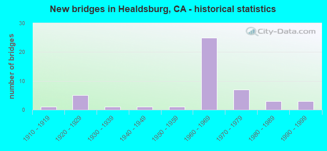
- New bridges - historical statistics
- 11910-1919
- 51920-1929
- 11930-1939
- 11940-1949
- 11950-1959
- 251960-1969
- 71970-1979
- 31980-1989
- 31990-1999

- Reconstructed bridges - Historical Statistics
- 21960-1969
- 21970-1979
- 01980-1989
- 01990-1999
- 12000-2009
- 12010-2019


- Bridge Condition - Deck
- 37.1%Good
- 14.3%Satisfactory
- 40.0%Fair
- 8.6%Poor

- Bridge Condition - Superstructure
- 60.0%Good
- 2.9%Satisfactory
- 37.1%Fair

- Bridge Condition - Substructure
- 65.7%Good
- 2.9%Satisfactory
- 28.6%Fair
- 2.9%Poor

- Bridge Condition - Channel
- 15.0%Excellent
- 10.0%Very good
- 55.0%Good
- 10.0%Satisfactory
- 10.0%Fair

- Bridge Condition - Culverts
- 33.3%Good
- 66.7%Satisfactory
Find on map >> Show street view
Structure Number: 20 004, Location: 04-SON-128-12.19 (Lat: 38.669531, Lng: -122.810394), Route carried "on" structure: State highway 128, Year Built: 1984, Status: Open, Structure Length: 3.26m (10.70ft), Average Daily Traffic: 2,750 (year 2016), Truck Traffic: 6%, Average Future Daily Traffic: 3,200 (year 2038), Design Load: HS 20+Mod, Features Intersected: SAUSAL CREEK
Minimum Vertical Clearance: 30+ m (98+ ft), Kilometerpoint: 12.190, Lanes on structure: 2, Base Highway Network: Yes (Inventory Route: 1, Subroute: 1), Owner: State Highway Agency, Approaching Roadway Width: 7.6m (24.9ft), Skew: 3 degrees, Material/Design: Concrete continuous, Design/Construction: Slab, Number Of Spans In Main Unit: 3, Length of Maximum Span: 10.7m (35.1ft), Curb or Sidewalk Widths: Left: 0.2m (0.7ft), Right: 0.2m (0.7ft), Curb-To-Curb Width: 9.8m (32.2ft), Out-to-Out Width: 10.8m (35.4ft)
Condition: Deck: Fair, Superstructure: Fair, Substructure: Good, Channel: Very good, Operating Rating: 54.1 metric tons, Method Used To Determine Operating Rating: Assigned rating based on Load Factor Design (LFD) reported in metric tons, Inventory Rating: 32.4 metric tons, Method Used To Determine Inventory Rating: Assigned rating based on Load Factor Design (LFD) reported in metric tons, Structural Evaluation: Somewhat better than minimum adequacy, Deck Geometry: Meets minimum limits, Waterway Adequacy: Equal to present desirable criteria, Approach Roadway Alignment: Superior to present desirable criteria, Designated Inspection Frequency: Every 24 months, Inspection Date: October 2020, Deck Structure Type: Concrete Cast-file-Place
Find on map >> Show street view
Structure Number: 20 0066, Location: 04-SON-101-32.79 (Lat: 38.587469, Lng: -122.844225), Route carried "on" structure: County highway , Year Built: 1962, Status: Open, Structure Length: 5.67m (18.60ft), Average Daily Traffic: 1,800 (year 2015), Truck Traffic: 2%, Average Future Daily Traffic: 6,244 (year 2038), Design Load: HS 20, Features Intersected: US HIGHWAY 101, Facility Carried by Structure: LIMERICK LANE
Minimum Vertical Clearance: 30+ m (98+ ft), Kilometerpoint: 0.000, Lanes on structure: 2, Lanes under structure: 4, Owner: State Highway Agency, Approaching Roadway Width: 7.3m (24.0ft), Skew: 3 degrees, Material/Design: Concrete continuous, Design/Construction: Box Beam or Girders - Multiple, Number Of Spans In Main Unit: 2, Length of Maximum Span: 27.4m (89.9ft), Curb or Sidewalk Widths: Left: 1.5m (4.9ft), Right: 0.0m, Curb-To-Curb Width: 9.8m (32.2ft), Out-to-Out Width: 12.3m (40.4ft)
Condition: Deck: Fair, Superstructure: Good, Substructure: Good, Operating Rating: 40.2 metric tons, Method Used To Determine Operating Rating: Load and Resistance Factor Rating (LRFR) rating reported by rating factor(RF) method using HL-93 loadings, Inventory Rating: 30.8 metric tons, Method Used To Determine Inventory Rating: Load and Resistance Factor Rating (LRFR) rating reported by rating factor(RF) method using HL-93 loadings, Structural Evaluation: Better than present minimum criteria, Deck Geometry: Somewhat better than minimum adequacy, Underclear: High priority of corrective action, Approach Roadway Alignment: Equal to present minimum criteria, Designated Inspection Frequency: Every 24 months, Inspection Date: April 2021, Deck Structure Type: Concrete Cast-file-Place
Find on map >> Show street view
Structure Number: 20 0067L, Location: 04-SON-101-33.48 (Lat: 38.594578, Lng: -122.852481), Route carried "on" structure: US 101, Year Built: 1962, Status: Open, Structure Length: 7.50m (24.61ft), Average Daily Traffic: 22,750 (year 2015), Truck Traffic: 13%, Average Future Daily Traffic: 43,153 (year 2038), Design Load: HS 20, Features Intersected: HEALDSBURG AVENUE
Minimum Vertical Clearance: 30+ m (98+ ft), Kilometerpoint: 33.480, Lanes on structure: 2, Lanes under structure: 4, Base Highway Network: Yes (Inventory Route: 1, Subroute: 1), Owner: State Highway Agency, Approaching Roadway Width: 11.3m (37.1ft), Skew: 5 degrees, Material/Design: Prestressed concrete, Design/Construction: Stringer/Multi-beam, Number Of Spans In Main Unit: 2, Number Of Approach Spans: 2, Length of Maximum Span: 23.2m (76.1ft), Curb-To-Curb Width: 11.3m (37.1ft), Out-to-Out Width: 12.1m (39.7ft)
Condition: Deck: Fair, Superstructure: Good, Substructure: Good, Operating Rating: 35.3 metric tons, Method Used To Determine Operating Rating: Load and Resistance Factor Rating (LRFR) rating reported by rating factor(RF) method using HL-93 loadings, Inventory Rating: 20.1 metric tons, Method Used To Determine Inventory Rating: Load and Resistance Factor Rating (LRFR) rating reported by rating factor(RF) method using HL-93 loadings, Structural Evaluation: Somewhat better than minimum adequacy, Deck Geometry: Somewhat better than minimum adequacy, Underclear: Meets minimum limits, Approach Roadway Alignment: Equal to present desirable criteria, Designated Inspection Frequency: Every 24 months, Inspection Date: April 2021, Deck Structure Type: Concrete Cast-file-Place
Find on map >> Show street view
Structure Number: 20 0067R, Location: 04-SON-101-33.48 (Lat: 38.594894, Lng: -122.852633), Route carried "on" structure: US 101, Year Built: 1962, Status: Open, Structure Length: 7.50m (24.61ft), Average Daily Traffic: 22,750 (year 2013), Truck Traffic: 13%, Average Future Daily Traffic: 43,153 (year 2039), Design Load: HS 20, Features Intersected: HEALDSBURG AVENUE
Minimum Vertical Clearance: 30+ m (98+ ft), Kilometerpoint: 33.480, Lanes on structure: 2, Lanes under structure: 4, Base Highway Network: Yes (Inventory Route: 1, Subroute: 1), Owner: State Highway Agency, Approaching Roadway Width: 11.0m (36.1ft), Skew: 5 degrees, Material/Design: Prestressed concrete, Design/Construction: Stringer/Multi-beam, Number Of Spans In Main Unit: 2, Number Of Approach Spans: 2, Length of Maximum Span: 23.2m (76.1ft), Curb-To-Curb Width: 11.3m (37.1ft), Out-to-Out Width: 12.1m (39.7ft)
Condition: Deck: Fair, Superstructure: Good, Substructure: Good, Operating Rating: 43.1 metric tons, Method Used To Determine Operating Rating: Load and Resistance Factor Rating (LRFR) rating reported by rating factor(RF) method using HL-93 loadings, Inventory Rating: 22.0 metric tons, Method Used To Determine Inventory Rating: Load and Resistance Factor Rating (LRFR) rating reported by rating factor(RF) method using HL-93 loadings, Structural Evaluation: Somewhat better than minimum adequacy, Deck Geometry: Somewhat better than minimum adequacy, Underclear: Meets minimum limits, Approach Roadway Alignment: Equal to present desirable criteria, Length Of Structure Improvement: 7.50m (24.61ft), Designated Inspection Frequency: Every 24 months, Inspection Date: April 2021, Deck Structure Type: Concrete Cast-file-Place
Find on map >> Show street view
Structure Number: 20 0082, Location: 04-SON-101-14.02-RNPK (Lat: 38.350481, Lng: -122.712914), Route carried "on" structure: US 101, Year Built: 1968, Year Reconstructed: 1970, Status: Open, Structure Length: 1.46m (4.79ft), Average Daily Traffic: 92,000 (year 2016), Truck Traffic: 6%, Average Future Daily Traffic: 166,227 (year 2038), Design Load: HS 20+Mod, Features Intersected: HINEBAUGH CREEK
Minimum Vertical Clearance: 30+ m (98+ ft), Kilometerpoint: 14.020, Lanes on structure: 11, Base Highway Network: Yes (Inventory Route: 1, Subroute: 1), Owner: State Highway Agency, Approaching Roadway Width: 89.5m (293.6ft), Skew: 10 degrees, Material/Design: Concrete continuous, Design/Construction: Culvert, Number Of Spans In Main Unit: 4, Length of Maximum Span: 3.4m (11.2ft)
Condition: Channel: Excellent, Culverts: Satisfactory, Operating Rating: 54.1 metric tons, Method Used To Determine Operating Rating: Field evaluation and documented engineering judgment, Inventory Rating: 32.4 metric tons, Method Used To Determine Inventory Rating: Field evaluation and documented engineering judgment, Structural Evaluation: Equal to present minimum criteria, Waterway Adequacy: Equal to present desirable criteria, Approach Roadway Alignment: Equal to present desirable criteria, Designated Inspection Frequency: Every 24 months, Inspection Date: April 2020
Find on map >> Show street view
Structure Number: 20 0085L, Location: 04-SON-101-34.55-HLBG (Lat: 38.603906, Lng: -122.868433), Route carried "on" structure: US 101, Year Built: 1960, Status: Open, Structure Length: 3.78m (12.40ft), Average Daily Traffic: 22,500 (year 2015), Truck Traffic: 13%, Average Future Daily Traffic: 34,158 (year 2038), Design Load: HS 20+Mod, Features Intersected: HEALDSBURG AV-S101 ON-RP
Minimum Vertical Clearance: 30+ m (98+ ft), Kilometerpoint: 34.550, Lanes on structure: 2, Lanes under structure: 1, Base Highway Network: Yes (Inventory Route: 1, Subroute: 1), Owner: State Highway Agency, Approaching Roadway Width: 11.3m (37.1ft), Skew: 3 degrees, Material/Design: Concrete continuous, Design/Construction: Tee Beam, Number Of Spans In Main Unit: 3, Length of Maximum Span: 16.5m (54.1ft), Curb or Sidewalk Widths: Left: 0.6m (2.0ft), Right: 0.6m (2.0ft), Curb-To-Curb Width: 11.3m (37.1ft), Out-to-Out Width: 12.7m (41.7ft)
Condition: Deck: Fair, Superstructure: Good, Substructure: Good, Operating Rating: 36.6 metric tons, Method Used To Determine Operating Rating: Load and Resistance Factor Rating (LRFR) rating reported by rating factor(RF) method using HL-93 loadings, Inventory Rating: 28.5 metric tons, Method Used To Determine Inventory Rating: Load and Resistance Factor Rating (LRFR) rating reported by rating factor(RF) method using HL-93 loadings, Structural Evaluation: Better than present minimum criteria, Deck Geometry: Somewhat better than minimum adequacy, Underclear: High priority of corrective action, Approach Roadway Alignment: Equal to present desirable criteria, Designated Inspection Frequency: Every 24 months, Inspection Date: April 2021, Deck Structure Type: Concrete Cast-file-Place
Find on map >> Show street view
Structure Number: 20 0085R, Location: 04-SON-101-34.55-HLBG (Lat: 38.604144, Lng: -122.868381), Route carried "on" structure: US 101, Year Built: 1960, Status: Open, Structure Length: 3.78m (12.40ft), Average Daily Traffic: 22,750 (year 2015), Truck Traffic: 13%, Average Future Daily Traffic: 43,153 (year 2039), Design Load: HS 20, Features Intersected: HEALDSBURG AV-S101 ON-RP
Minimum Vertical Clearance: 30+ m (98+ ft), Kilometerpoint: 34.550, Lanes on structure: 2, Lanes under structure: 4, Base Highway Network: Yes (Inventory Route: 1, Subroute: 1), Owner: State Highway Agency, Approaching Roadway Width: 11.3m (37.1ft), Skew: 3 degrees, Material/Design: Concrete continuous, Design/Construction: Tee Beam, Number Of Spans In Main Unit: 3, Length of Maximum Span: 16.5m (54.1ft), Curb or Sidewalk Widths: Left: 0.6m (2.0ft), Right: 0.6m (2.0ft), Curb-To-Curb Width: 11.3m (37.1ft), Out-to-Out Width: 12.7m (41.7ft)
Condition: Deck: Fair, Superstructure: Good, Substructure: Good, Operating Rating: 36.6 metric tons, Method Used To Determine Operating Rating: Load and Resistance Factor Rating (LRFR) rating reported by rating factor(RF) method using HL-93 loadings, Inventory Rating: 28.5 metric tons, Method Used To Determine Inventory Rating: Load and Resistance Factor Rating (LRFR) rating reported by rating factor(RF) method using HL-93 loadings, Structural Evaluation: Better than present minimum criteria, Deck Geometry: Somewhat better than minimum adequacy, Underclear: Somewhat better than minimum adequacy, Approach Roadway Alignment: Equal to present desirable criteria, Designated Inspection Frequency: Every 24 months, Inspection Date: April 2021, Deck Structure Type: Concrete Cast-file-Place
Find on map >> Show street view
Structure Number: 20 0088L, Location: 04-SON-101-33.22 (Lat: 38.592464, Lng: -122.848556), Route carried "on" structure: US 101, Year Built: 1962, Status: Open, Structure Length: 7.16m (23.49ft), Average Daily Traffic: 22,750 (year 2019), Truck Traffic: 15%, Average Future Daily Traffic: 50,753 (year 2038), Design Load: HS 20+Mod, Features Intersected: NWP RR/NCRRA
Minimum Vertical Clearance: 30+ m (98+ ft), Kilometerpoint: 33.220, Lanes on structure: 2, Base Highway Network: Yes (Inventory Route: 1, Subroute: 1), Owner: State Highway Agency, Approaching Roadway Width: 12.5m (41.0ft), Skew: 5 degrees, Material/Design: Prestressed concrete, Design/Construction: Stringer/Multi-beam, Number Of Spans In Main Unit: 3, Length of Maximum Span: 23.2m (76.1ft), Curb-To-Curb Width: 12.5m (41.0ft), Out-to-Out Width: 13.8m (45.3ft)
Condition: Deck: Fair, Superstructure: Good, Substructure: Good, Operating Rating: 42.1 metric tons, Method Used To Determine Operating Rating: Load and Resistance Factor Rating (LRFR) rating reported by rating factor(RF) method using HL-93 loadings, Inventory Rating: 22.7 metric tons, Method Used To Determine Inventory Rating: Load and Resistance Factor Rating (LRFR) rating reported by rating factor(RF) method using HL-93 loadings, Structural Evaluation: Somewhat better than minimum adequacy, Deck Geometry: Better than present minimum criteria, Underclear: Somewhat better than minimum adequacy, Approach Roadway Alignment: Equal to present desirable criteria, Designated Inspection Frequency: Every 24 months, Inspection Date: April 2021, Deck Structure Type: Concrete Cast-file-Place
Find on map >> Show street view
Structure Number: 20 0088R, Location: 04-SON-101-33.22 (Lat: 38.592800, Lng: -122.848678), Route carried "on" structure: US 101, Year Built: 1962, Status: Open, Structure Length: 6.98m (22.90ft), Average Daily Traffic: 22,750 (year 2017), Truck Traffic: 15%, Average Future Daily Traffic: 50,753 (year 2039), Design Load: HS 20+Mod, Features Intersected: NWP RR/NCRRA
Minimum Vertical Clearance: 30+ m (98+ ft), Kilometerpoint: 33.220, Lanes on structure: 2, Base Highway Network: Yes (Inventory Route: 1, Subroute: 1), Owner: State Highway Agency, Approaching Roadway Width: 11.3m (37.1ft), Skew: 5 degrees, Material/Design: Prestressed concrete, Design/Construction: Stringer/Multi-beam, Number Of Spans In Main Unit: 3, Length of Maximum Span: 22.6m (74.1ft), Curb-To-Curb Width: 11.3m (37.1ft), Out-to-Out Width: 12.1m (39.7ft)
Condition: Deck: Satisfactory, Superstructure: Good, Substructure: Good, Operating Rating: 38.6 metric tons, Method Used To Determine Operating Rating: Load and Resistance Factor Rating (LRFR) rating reported by rating factor(RF) method using HL-93 loadings, Inventory Rating: 21.1 metric tons, Method Used To Determine Inventory Rating: Load and Resistance Factor Rating (LRFR) rating reported by rating factor(RF) method using HL-93 loadings, Structural Evaluation: Somewhat better than minimum adequacy, Deck Geometry: Somewhat better than minimum adequacy, Underclear: Somewhat better than minimum adequacy, Approach Roadway Alignment: Better than present minimum criteria, Designated Inspection Frequency: Every 24 months, Inspection Date: April 2021, Deck Structure Type: Concrete Cast-file-Place
Find on map >> Show street view
Structure Number: 20 0144, Location: 04-SON-101-36.27 (Lat: 38.626025, Lng: -122.878028), Route carried "on" structure: US 101, Year Built: 1960, Status: Open, Structure Length: 5.39m (17.68ft), Average Daily Traffic: 45,500 (year 2015), Truck Traffic: 13%, Average Future Daily Traffic: 86,306 (year 2038), Design Load: HS 20, Features Intersected: DRY CREEK ROAD
Minimum Vertical Clearance: 30+ m (98+ ft), Kilometerpoint: 36.270, Lanes on structure: 4, Lanes under structure: 2, Base Highway Network: Yes (Inventory Route: 1, Subroute: 1), Owner: State Highway Agency, Approaching Roadway Width: 26.2m (86.0ft), Skew: 30 degrees, Material/Design: Concrete continuous, Design/Construction: Box Beam or Girders - Multiple, Number Of Spans In Main Unit: 3, Length of Maximum Span: 26.5m (86.9ft), Curb-To-Curb Width: 22.6m (74.1ft), Out-to-Out Width: 27.8m (91.2ft)
Condition: Deck: Poor, Superstructure: Good, Substructure: Good, Operating Rating: 42.8 metric tons, Method Used To Determine Operating Rating: Load and Resistance Factor Rating (LRFR) rating reported by rating factor(RF) method using HL-93 loadings, Inventory Rating: 33.0 metric tons, Method Used To Determine Inventory Rating: Load and Resistance Factor Rating (LRFR) rating reported by rating factor(RF) method using HL-93 loadings, Structural Evaluation: Better than present minimum criteria, Deck Geometry: Superior to present desirable criteria, Underclear: Better than present minimum criteria, Approach Roadway Alignment: Equal to present desirable criteria, Length Of Structure Improvement: 5.39m (17.68ft), Designated Inspection Frequency: Every 24 months, Inspection Date: April 2021, Deck Structure Type: Concrete Cast-file-Place
Find on map >> Show street view
Structure Number: 20 0146L, Location: 04-SON-101-36.95 (Lat: 38.635886, Lng: -122.877558), Route carried "on" structure: US 101, Year Built: 1960, Status: Open, Structure Length: 4.27m (14.01ft), Average Daily Traffic: 22,500 (year 2019), Truck Traffic: 13%, Average Future Daily Traffic: 34,158 (year 2038), Design Load: HS 20, Features Intersected: CHIQUITA ROAD
Minimum Vertical Clearance: 30+ m (98+ ft), Kilometerpoint: 36.950, Lanes on structure: 2, Lanes under structure: 2, Base Highway Network: Yes (Inventory Route: 1, Subroute: 1), Owner: State Highway Agency, Approaching Roadway Width: 11.4m (37.4ft), Skew: 2 degrees, Material/Design: Concrete continuous, Design/Construction: Tee Beam, Number Of Spans In Main Unit: 3, Length of Maximum Span: 18.9m (62.0ft), Curb or Sidewalk Widths: Left: 0.6m (2.0ft), Right: 0.0m, Curb-To-Curb Width: 11.4m (37.4ft), Out-to-Out Width: 12.8m (42.0ft)
Condition: Deck: Poor, Superstructure: Good, Substructure: Good, Operating Rating: 39.5 metric tons, Method Used To Determine Operating Rating: Load and Resistance Factor Rating (LRFR) rating reported by rating factor(RF) method using HL-93 loadings, Inventory Rating: 30.5 metric tons, Method Used To Determine Inventory Rating: Load and Resistance Factor Rating (LRFR) rating reported by rating factor(RF) method using HL-93 loadings, Structural Evaluation: Better than present minimum criteria, Deck Geometry: Somewhat better than minimum adequacy, Underclear: Somewhat better than minimum adequacy, Approach Roadway Alignment: Equal to present desirable criteria, Length Of Structure Improvement: 4.27m (14.01ft), Designated Inspection Frequency: Every 24 months, Inspection Date: April 2021, Bridge Improvement Cost: $547,000, Roadway Improvement Cost: $109,000, Total Project Cost: $918,000 ( Estimate for 2020), Deck Structure Type: Concrete Cast-file-Place
Find on map >> Show street view
Structure Number: 20 0146R, Location: 04-SON-101-36.95 (Lat: 38.635800, Lng: -122.877392), Route carried "on" structure: US 101, Year Built: 1960, Status: Open, Structure Length: 4.27m (14.01ft), Average Daily Traffic: 22,750 (year 2015), Truck Traffic: 13%, Average Future Daily Traffic: 43,153 (year 2039), Design Load: HS 20, Features Intersected: CHIQUITA ROAD
Minimum Vertical Clearance: 30+ m (98+ ft), Kilometerpoint: 36.950, Lanes on structure: 2, Lanes under structure: 2, Base Highway Network: Yes (Inventory Route: 1, Subroute: 1), Owner: State Highway Agency, Approaching Roadway Width: 11.4m (37.4ft), Skew: 2 degrees, Material/Design: Concrete continuous, Design/Construction: Tee Beam, Number Of Spans In Main Unit: 3, Length of Maximum Span: 18.9m (62.0ft), Curb or Sidewalk Widths: Left: 0.0m, Right: 0.6m (2.0ft), Curb-To-Curb Width: 11.4m (37.4ft), Out-to-Out Width: 12.8m (42.0ft)
Condition: Deck: Fair, Superstructure: Good, Substructure: Good, Operating Rating: 39.5 metric tons, Method Used To Determine Operating Rating: Load and Resistance Factor Rating (LRFR) rating reported by rating factor(RF) method using HL-93 loadings, Inventory Rating: 30.5 metric tons, Method Used To Determine Inventory Rating: Load and Resistance Factor Rating (LRFR) rating reported by rating factor(RF) method using HL-93 loadings, Structural Evaluation: Better than present minimum criteria, Deck Geometry: Somewhat better than minimum adequacy, Underclear: Somewhat better than minimum adequacy, Approach Roadway Alignment: Equal to present desirable criteria, Designated Inspection Frequency: Every 24 months, Inspection Date: April 2021, Deck Structure Type: Concrete Cast-file-Place
Find on map >> Show street view
Structure Number: 20 0147, Location: 04-SON-101-34.88 (Lat: 38.607158, Lng: -122.872703), Route carried "on" structure: US 101, Year Built: 1960, Status: Open, Structure Length: 5.55m (18.21ft), Average Daily Traffic: 45,500 (year 2017), Truck Traffic: 13%, Average Future Daily Traffic: 86,306 (year 2039), Design Load: HS 20+Mod, Features Intersected: WESTSIDE RD
Minimum Vertical Clearance: 30+ m (98+ ft), Kilometerpoint: 34.880, Lanes on structure: 4, Lanes under structure: 2, Base Highway Network: Yes (Inventory Route: 1, Subroute: 1), Owner: State Highway Agency, Approaching Roadway Width: 26.2m (86.0ft), Skew: 31 degrees, Material/Design: Concrete continuous, Design/Construction: Box Beam or Girders - Multiple, Number Of Spans In Main Unit: 3, Length of Maximum Span: 28.0m (91.9ft), Curb-To-Curb Width: 22.6m (74.1ft), Out-to-Out Width: 27.8m (91.2ft)
Condition: Deck: Poor, Superstructure: Good, Substructure: Good, Operating Rating: 41.1 metric tons, Method Used To Determine Operating Rating: Load and Resistance Factor Rating (LRFR) rating reported by rating factor(RF) method using HL-93 loadings, Inventory Rating: 31.8 metric tons, Method Used To Determine Inventory Rating: Load and Resistance Factor Rating (LRFR) rating reported by rating factor(RF) method using HL-93 loadings, Structural Evaluation: Better than present minimum criteria, Deck Geometry: Superior to present desirable criteria, Underclear: Equal to present minimum criteria, Approach Roadway Alignment: Better than present minimum criteria, Designated Inspection Frequency: Every 24 months, Inspection Date: April 2021, Deck Structure Type: Concrete Cast-file-Place
Find on map >> Show street view
Structure Number: 20 0233R, Location: 04-SON-101-R38.56 (Lat: 38.659328, Lng: -122.874139), Route carried "on" structure: US 101, Year Built: 1974, Status: Open, Structure Length: 4.97m (16.31ft), Average Daily Traffic: 14,250 (year 2015), Truck Traffic: 11%, Average Future Daily Traffic: 26,575 (year 2039), Design Load: HS 20, Features Intersected: LYTTON SPRINGS ROAD
Minimum Vertical Clearance: 30+ m (98+ ft), Kilometerpoint: 38.560, Lanes on structure: 2, Lanes under structure: 2, Base Highway Network: Yes (Inventory Route: 1, Subroute: 1), Owner: State Highway Agency, Approaching Roadway Width: 11.9m (39.0ft), Skew: 3 degrees, Material/Design: Prestressed concrete, Design/Construction: Box Beam or Girders - Multiple, Number Of Spans In Main Unit: 1, Length of Maximum Span: 49.1m (161.1ft), Curb-To-Curb Width: 11.9m (39.0ft), Out-to-Out Width: 12.5m (41.0ft)
Condition: Deck: Good, Superstructure: Good, Substructure: Fair, Operating Rating: 51.5 metric tons, Method Used To Determine Operating Rating: Load and Resistance Factor Rating (LRFR) rating reported by rating factor(RF) method using HL-93 loadings, Inventory Rating: 32.1 metric tons, Method Used To Determine Inventory Rating: Load and Resistance Factor Rating (LRFR) rating reported by rating factor(RF) method using HL-93 loadings, Structural Evaluation: Somewhat better than minimum adequacy, Deck Geometry: Better than present minimum criteria, Underclear: Better than present minimum criteria, Approach Roadway Alignment: Superior to present desirable criteria, Designated Inspection Frequency: Every 24 months, Inspection Date: April 2021, Deck Structure Type: Concrete Cast-file-Place
Find on map >> Show street view
Structure Number: 20 0273L, Location: 04-SON-101-33.78-HLBG (Lat: 38.597003, Lng: -122.857175), Route carried "on" structure: US 101, Year Built: 1999, Status: Open, Structure Length: 23.56m (77.30ft), Average Daily Traffic: 22,750 (year 2019), Truck Traffic: 13%, Average Future Daily Traffic: 43,153 (year 2038), Design Load: HS 20+Mod, Features Intersected: RUSSIAN RIVER
Minimum Vertical Clearance: 30+ m (98+ ft), Kilometerpoint: 33.780, Lanes on structure: 2, Base Highway Network: Yes (Inventory Route: 1, Subroute: 1), Owner: State Highway Agency, Approaching Roadway Width: 11.9m (39.0ft), Material/Design: Prestressed concrete continuous, Design/Construction: Box Beam or Girders - Multiple, Number Of Spans In Main Unit: 4, Length of Maximum Span: 66.4m (217.8ft), Curb-To-Curb Width: 11.9m (39.0ft), Out-to-Out Width: 12.9m (42.3ft)
Condition: Deck: Satisfactory, Superstructure: Good, Substructure: Good, Channel: Excellent, Operating Rating: 54.1 metric tons, Method Used To Determine Operating Rating: Assigned rating based on Load Factor Design (LFD) reported in metric tons, Inventory Rating: 32.4 metric tons, Method Used To Determine Inventory Rating: Assigned rating based on Load Factor Design (LFD) reported in metric tons, Structural Evaluation: Better than present minimum criteria, Deck Geometry: Equal to present minimum criteria, Waterway Adequacy: Equal to present desirable criteria, Approach Roadway Alignment: Equal to present desirable criteria, Designated Inspection Frequency: Every 24 months, Inspection Date: April 2021, Deck Structure Type: Concrete Cast-file-Place
Find on map >> Show street view
Structure Number: 20 0273R, Location: 04-SON-101-33.78-HLBG (Lat: 38.597269, Lng: -122.857217), Route carried "on" structure: US 101, Year Built: 1999, Status: Open, Structure Length: 23.56m (77.30ft), Average Daily Traffic: 22,750 (year 2015), Truck Traffic: 13%, Average Future Daily Traffic: 43,153 (year 2039), Design Load: HS 20+Mod, Features Intersected: RUSSIAN RIVER
Minimum Vertical Clearance: 30+ m (98+ ft), Kilometerpoint: 33.780, Lanes on structure: 2, Base Highway Network: Yes (Inventory Route: 1, Subroute: 1), Owner: State Highway Agency, Approaching Roadway Width: 11.9m (39.0ft), Material/Design: Prestressed concrete continuous, Design/Construction: Box Beam or Girders - Multiple, Number Of Spans In Main Unit: 4, Length of Maximum Span: 66.4m (217.8ft), Curb-To-Curb Width: 11.9m (39.0ft), Out-to-Out Width: 12.9m (42.3ft)
Condition: Deck: Satisfactory, Superstructure: Good, Substructure: Good, Channel: Excellent, Operating Rating: 54.1 metric tons, Method Used To Determine Operating Rating: Assigned rating based on Load Factor Design (LFD) reported in metric tons, Inventory Rating: 32.4 metric tons, Method Used To Determine Inventory Rating: Assigned rating based on Load Factor Design (LFD) reported in metric tons, Structural Evaluation: Better than present minimum criteria, Deck Geometry: Equal to present minimum criteria, Waterway Adequacy: Equal to present desirable criteria, Approach Roadway Alignment: Equal to present desirable criteria, Designated Inspection Frequency: Every 24 months, Inspection Date: April 2021, Deck Structure Type: Concrete Cast-file-Place
Find on map >> Show street view
Structure Number: 20C0006, Location: NORTH OF HEALDSBURG (Lat: 38.658339, Lng: -122.830003), Route carried "on" structure: County highway , Year Built: 1949, Status: Open, Structure Length: 42.18m (138.39ft), Average Daily Traffic: 3,300 (year 2012), Truck Traffic: 2%, Average Future Daily Traffic: 3,955 (year 2043), Design Load: HS 20, Features Intersected: RUSSIAN RIVER - JIMTOWN, Facility Carried by Structure: ALEXANDER VALLEY R
Minimum Vertical Clearance: 30+ m (98+ ft), Kilometerpoint: 0.000, Lanes on structure: 2, Owner: County Highway Agency, Approaching Roadway Width: 7.3m (24.0ft), Material/Design: Steel continuous, Design/Construction: Truss - Thru, Number Of Spans In Main Unit: 5, Number Of Approach Spans: 30, Length of Maximum Span: 36.6m (120.1ft), Curb or Sidewalk Widths: Left: 0.5m (1.6ft), Right: 0.5m (1.6ft), Curb-To-Curb Width: 7.3m (24.0ft), Out-to-Out Width: 8.5m (27.9ft)
Condition: Deck: Fair, Superstructure: Fair, Substructure: Good, Channel: Satisfactory, Operating Rating: 33.7 metric tons, Method Used To Determine Operating Rating: Load Factor (LF), Inventory Rating: 15.6 metric tons, Method Used To Determine Inventory Rating: Load Factor (LF), Structural Evaluation: Meets minimum limits, Deck Geometry: High priority of replacement, Waterway Adequacy: Better than present minimum criteria, Approach Roadway Alignment: Better than present minimum criteria, Length Of Structure Improvement: 42.18m (138.39ft), Designated Inspection Frequency: Every 24 months, Critical Feature Inspection Frequency: Every 24 months, Inspection Date: July 2021, Critical Feature Inspection Date: October 2021, Bridge Improvement Cost: $8,245,000, Roadway Improvement Cost: $1,649,000, Total Project Cost: $13,852,000 ( Estimate for 2020), Deck Structure Type: Concrete Cast-file-Place
Find on map >> Show street view
Structure Number: 20C0065, Location: 35.2 MI N MARIN CO LINE (Lat: 38.603878, Lng: -122.860844), Route carried "on" structure: City street , Year Built: 1921, Year Reconstructed: 2016, Status: Open, Structure Length: 13.31m (43.67ft), Average Daily Traffic: 8,204 (year 2015), Truck Traffic: 5%, Average Future Daily Traffic: 8,495 (year 2038), Design Load: HS 20, Features Intersected: RUSSIAN RIVER, Facility Carried by Structure: HEALDSBURG AVE
Minimum Vertical Clearance: 4.54m (14.90ft), Kilometerpoint: 0.000, Lanes on structure: 2, Owner: City or Municipal Highway Agency, Approaching Roadway Width: 7.3m (24.0ft), Material/Design: Steel, Design/Construction: Truss - Thru, Number Of Spans In Main Unit: 2, Number Of Approach Spans: 2, Length of Maximum Span: 60.4m (198.2ft), Curb or Sidewalk Widths: Left: 2.4m (7.9ft), Right: 2.4m (7.9ft), Curb-To-Curb Width: 6.4m (21.0ft), Out-to-Out Width: 11.2m (36.7ft)
Condition: Deck: Fair, Superstructure: Good, Substructure: Good, Channel: Very good, Operating Rating: 54.1 metric tons, Method Used To Determine Operating Rating: Assigned rating based on Load Factor Design (LFD) reported in metric tons, Inventory Rating: 32.4 metric tons, Method Used To Determine Inventory Rating: Assigned rating based on Load Factor Design (LFD) reported in metric tons, Structural Evaluation: Better than present minimum criteria, Deck Geometry: High priority of replacement, Waterway Adequacy: Equal to present desirable criteria, Approach Roadway Alignment: Equal to present minimum criteria, Designated Inspection Frequency: Every 24 months, Critical Feature Inspection Frequency: Every 24 months, Underwater Inspection Frequency: Every 60 months, Inspection Date: May 2021, Critical Feature Inspection Date: October 2021, Underwater Inspection Date: October 2019, Deck Structure Type: Concrete Cast-file-Place
Find on map >> Show street view
Structure Number: 20C0066, Location: INT OF BAILACHE AVE (Lat: 38.603375, Lng: -122.856583), Route carried "on" structure: City street , Year Built: 1987, Status: Open, Structure Length: 4.21m (13.81ft), Average Daily Traffic: 8,204 (year 2010), Truck Traffic: 3%, Average Future Daily Traffic: 8,666 (year 2041), Design Load: HS 20+Mod, Features Intersected: RUSSIAN RIVER OVERFLOW, Facility Carried by Structure: HEALDSBURG AVE
Minimum Vertical Clearance: 30+ m (98+ ft), Kilometerpoint: 0.000, Lanes on structure: 3, Lanes under structure: 3, Base Highway Network: Yes, Owner: City or Municipal Highway Agency, Approaching Roadway Width: 9.8m (32.2ft), Skew: 2 degrees, Material/Design: Concrete continuous, Design/Construction: Slab, Number Of Spans In Main Unit: 5, Length of Maximum Span: 9.1m (29.9ft), Curb or Sidewalk Widths: Left: 1.5m (4.9ft), Right: 1.5m (4.9ft), Curb-To-Curb Width: 14.6m (47.9ft), Out-to-Out Width: 18.3m (60.0ft)
Condition: Deck: Fair, Superstructure: Fair, Substructure: Good, Operating Rating: 35.0 metric tons, Method Used To Determine Operating Rating: Load and Resistance Factor Rating (LRFR) rating reported by rating factor(RF) method using HL-93 loadings, Inventory Rating: 26.9 metric tons, Method Used To Determine Inventory Rating: Load and Resistance Factor Rating (LRFR) rating reported by rating factor(RF) method using HL-93 loadings, Structural Evaluation: Somewhat better than minimum adequacy, Deck Geometry: Somewhat better than minimum adequacy, Underclear: Meets minimum limits, Approach Roadway Alignment: Equal to present minimum criteria, Designated Inspection Frequency: Every 24 months, Inspection Date: May 2021, Deck Structure Type: Concrete Cast-file-Place
Find on map >> Show street view
Structure Number: 20C0071, Location: 0.2 MI N FOREMAN LANE (Lat: 38.582264, Lng: -122.880264), Route carried "on" structure: County highway , Year Built: 1961, Status: Open, Structure Length: 3.51m (11.52ft), Average Daily Traffic: 3,200 (year 2015), Truck Traffic: 1%, Average Future Daily Traffic: 3,226 (year 2040), Design Load: HS 20, Features Intersected: MILL CREEK, Facility Carried by Structure: WESTSIDE ROAD
Minimum Vertical Clearance: 30+ m (98+ ft), Kilometerpoint: 0.000, Lanes on structure: 2, Owner: County Highway Agency, Approaching Roadway Width: 11.6m (38.1ft), Skew: 4 degrees, Material/Design: Concrete continuous, Design/Construction: Tee Beam, Number Of Spans In Main Unit: 3, Length of Maximum Span: 14.0m (45.9ft), Curb-To-Curb Width: 12.3m (40.4ft), Out-to-Out Width: 12.5m (41.0ft)
Condition: Deck: Satisfactory, Superstructure: Good, Substructure: Satisfactory, Channel: Satisfactory, Operating Rating: 28.2 metric tons, Method Used To Determine Operating Rating: Load and Resistance Factor Rating (LRFR) rating reported by rating factor(RF) method using HL-93 loadings, Inventory Rating: 20.1 metric tons, Method Used To Determine Inventory Rating: Load and Resistance Factor Rating (LRFR) rating reported by rating factor(RF) method using HL-93 loadings, Structural Evaluation: Somewhat better than minimum adequacy, Deck Geometry: Equal to present minimum criteria, Waterway Adequacy: Better than present minimum criteria, Approach Roadway Alignment: Equal to present desirable criteria, Designated Inspection Frequency: Every 24 months, Inspection Date: October 2020, Deck Structure Type: Concrete Cast-file-Place
Find on map >> Show street view
Structure Number: 20C0154, Location: INTERSECTION LYTTON RD (Lat: 38.648708, Lng: -122.910233), Route carried "on" structure: County highway , Year Built: 1935, Status: Open, Structure Length: 0.67m (2.20ft), Average Daily Traffic: 2,800 (year 2015), Truck Traffic: 5%, Average Future Daily Traffic: 5,291 (year 2040), Features Intersected: LYTTON SPRINGS CREEK, Facility Carried by Structure: DRY CRK CANYON RD
Minimum Vertical Clearance: 30+ m (98+ ft), Kilometerpoint: 0.000, Lanes on structure: 2, Owner: County Highway Agency, Approaching Roadway Width: 11.3m (37.1ft), Material/Design: Concrete continuous, Design/Construction: Culvert, Number Of Spans In Main Unit: 2, Length of Maximum Span: 3.0m (9.8ft)
Condition: Channel: Good, Culverts: Satisfactory, Operating Rating: 27.2 metric tons, Method Used To Determine Operating Rating: Field evaluation and documented engineering judgment, Inventory Rating: 16.2 metric tons, Method Used To Determine Inventory Rating: Field evaluation and documented engineering judgment, Structural Evaluation: Meets minimum limits, Waterway Adequacy: Somewhat better than minimum adequacy, Approach Roadway Alignment: Equal to present desirable criteria, Designated Inspection Frequency: Every 24 months, Inspection Date: October 2020
Find on map >> Show street view
Structure Number: 20C0177, Location: 1/4 MILE EAST OF SR 101 (Lat: 38.626164, Lng: -122.875286), Route carried "on" structure: County highway , Year Built: 1962, Status: Open, Structure Length: 0.67m (2.20ft), Average Daily Traffic: 17,950 (year 2015), Truck Traffic: 10%, Average Future Daily Traffic: 20,550 (year 2038), Features Intersected: FOSS CREEK, Facility Carried by Structure: DRY CREEK RD
Minimum Vertical Clearance: 30+ m (98+ ft), Kilometerpoint: 0.000, Lanes on structure: 4, Base Highway Network: Yes, Owner: City or Municipal Highway Agency, Approaching Roadway Width: 12.5m (41.0ft), Material/Design: Concrete continuous, Design/Construction: Culvert, Number Of Spans In Main Unit: 2, Length of Maximum Span: 3.1m (10.2ft), Curb or Sidewalk Widths: Left: 0.2m (0.7ft), Right: 2.2m (7.2ft), Curb-To-Curb Width: 20.7m (67.9ft), Out-to-Out Width: 22.7m (74.5ft)
Condition: Channel: Fair, Culverts: Good, Operating Rating: 40.5 metric tons, Method Used To Determine Operating Rating: Field evaluation and documented engineering judgment, Inventory Rating: 24.3 metric tons, Method Used To Determine Inventory Rating: Field evaluation and documented engineering judgment, Structural Evaluation: Equal to present minimum criteria, Deck Geometry: Superior to present desirable criteria, Waterway Adequacy: Better than present minimum criteria, Approach Roadway Alignment: Equal to present desirable criteria, Designated Inspection Frequency: Every 24 months, Inspection Date: May 2021, Deck Structure Type: Concrete Cast-file-Place, Wearing Surface/Protective System: Wearing Surface: Bituminous
Find on map >> Show street view
Structure Number: 20C0248, Location: 0.4 MI W OF DRY CREEK RD (Lat: 38.654019, Lng: -122.927700), Route carried "on" structure: County highway , Year Built: 1915, Status: Open, Structure Length: 5.74m (18.83ft), Average Daily Traffic: 838 (year 2008), Truck Traffic: 1%, Average Future Daily Traffic: 1,301 (year 2043), Features Intersected: DRY CREEK, Facility Carried by Structure: LAMBERT BRIDGE RD
Minimum Vertical Clearance: 3.98m (13.06ft), Kilometerpoint: 0.000, Lanes on structure: 1, Owner: County Highway Agency, Approaching Roadway Width: 5.8m (19.0ft), Material/Design: Steel, Design/Construction: Truss - Thru, Number Of Spans In Main Unit: 1, Length of Maximum Span: 56.5m (185.4ft), Curb-To-Curb Width: 5.0m (16.4ft), Out-to-Out Width: 5.2m (17.1ft)
Condition: Deck: Fair, Superstructure: Fair, Substructure: Fair, Channel: Good, Operating Rating: 30.5 metric tons, Method Used To Determine Operating Rating: Load Factor (LF), Inventory Rating: 18.1 metric tons, Method Used To Determine Inventory Rating: Load Factor (LF), Structural Evaluation: Somewhat better than minimum adequacy, Deck Geometry: High priority of replacement, Waterway Adequacy: Better than present minimum criteria, Approach Roadway Alignment: High priority of corrective action, Designated Inspection Frequency: Every 24 months, Critical Feature Inspection Frequency: Every 24 months, Inspection Date: July 2021, Critical Feature Inspection Date: May 2021, Deck Structure Type: Concrete Cast-file-Place
Find on map >> Show street view
Structure Number: 20C025, Location: NEAR SKIMMER RD (Lat: 38.591258, Lng: -122.865753), Route carried "on" structure: County highway , Year Built: 1979, Status: Open, Structure Length: 3.47m (11.38ft), Average Daily Traffic: 100 (year 2015), Average Future Daily Traffic: 183 (year 2040), Design Load: HS 20, Features Intersected: WEST SLOUGH, Facility Carried by Structure: MAGNOLIA DR
Minimum Vertical Clearance: 30+ m (98+ ft), Kilometerpoint: 0.000, Lanes on structure: 2, Owner: County Highway Agency, Approaching Roadway Width: 3.7m (12.1ft), Skew: 1 degrees, Material/Design: Concrete continuous, Design/Construction: Slab, Number Of Spans In Main Unit: 4, Length of Maximum Span: 9.8m (32.2ft), Curb-To-Curb Width: 8.5m (27.9ft), Out-to-Out Width: 8.7m (28.5ft)
Condition: Deck: Good, Superstructure: Good, Substructure: Good, Channel: Good, Operating Rating: 50.5 metric tons, Method Used To Determine Operating Rating: Load and Resistance Factor Rating (LRFR) rating reported by rating factor(RF) method using HL-93 loadings, Inventory Rating: 39.2 metric tons, Method Used To Determine Inventory Rating: Load and Resistance Factor Rating (LRFR) rating reported by rating factor(RF) method using HL-93 loadings, Structural Evaluation: Better than present minimum criteria, Deck Geometry: Better than present minimum criteria, Waterway Adequacy: Equal to present desirable criteria, Approach Roadway Alignment: Equal to present desirable criteria, Designated Inspection Frequency: Every 48 months, Inspection Date: May 2019, Deck Structure Type: Concrete Cast-file-Place
Find on map >> Show street view
Structure Number: 20C0341, Location: 0.2 MI N OF US HWY 101 (Lat: 38.508986, Lng: -122.769847), Route carried "on" structure: County highway , Year Built: 1971, Status: Open, Structure Length: 4.82m (15.81ft), Average Daily Traffic: 14,650 (year 2015), Truck Traffic: 4%, Average Future Daily Traffic: 26,630 (year 2040), Features Intersected: MARK WEST CREEK, Facility Carried by Structure: FULTON RD
Minimum Vertical Clearance: 30+ m (98+ ft), Kilometerpoint: 0.000, Lanes on structure: 2, Owner: County Highway Agency, Approaching Roadway Width: 11.6m (38.1ft), Material/Design: Concrete continuous, Design/Construction: Box Beam or Girders - Multiple, Number Of Spans In Main Unit: 3, Length of Maximum Span: 18.9m (62.0ft), Curb-To-Curb Width: 12.2m (40.0ft), Out-to-Out Width: 12.4m (40.7ft)
Condition: Deck: Fair, Superstructure: Fair, Substructure: Good, Channel: Good, Operating Rating: 28.2 metric tons, Method Used To Determine Operating Rating: Field evaluation and documented engineering judgment, Inventory Rating: 16.8 metric tons, Method Used To Determine Inventory Rating: Field evaluation and documented engineering judgment, Structural Evaluation: Meets minimum limits, Deck Geometry: Somewhat better than minimum adequacy, Waterway Adequacy: Equal to present desirable criteria, Approach Roadway Alignment: Equal to present desirable criteria, Designated Inspection Frequency: Every 24 months, Inspection Date: June 2021, Deck Structure Type: Concrete Cast-file-Place
Find on map >> Show street view
Structure Number: 20C0343, Location: IN HEALDSBURG (Lat: 38.615814, Lng: -122.876647), Route carried "on" structure: City street , Year Built: 1920, Status: Open, Structure Length: 1.13m (3.71ft), Average Daily Traffic: 1,830 (year 2015), Truck Traffic: 1%, Average Future Daily Traffic: 4,101 (year 2041), Features Intersected: FOSS CREEK, Facility Carried by Structure: GRANT ST
Minimum Vertical Clearance: 30+ m (98+ ft), Kilometerpoint: 0.000, Lanes on structure: 2, Owner: City or Municipal Highway Agency, Approaching Roadway Width: 6.8m (22.3ft), Skew: 3 degrees, Material/Design: Concrete continuous, Design/Construction: Tee Beam, Number Of Spans In Main Unit: 2, Length of Maximum Span: 5.8m (19.0ft), Curb-To-Curb Width: 6.8m (22.3ft), Out-to-Out Width: 6.8m (22.3ft)
Condition: Deck: Good, Superstructure: Good, Substructure: Fair, Channel: Good, Operating Rating: 28.2 metric tons, Method Used To Determine Operating Rating: Load and Resistance Factor Rating (LRFR) rating reported by rating factor(RF) method using HL-93 loadings, Inventory Rating: 19.8 metric tons, Method Used To Determine Inventory Rating: Load and Resistance Factor Rating (LRFR) rating reported by rating factor(RF) method using HL-93 loadings, Structural Evaluation: Somewhat better than minimum adequacy, Deck Geometry: High priority of corrective action, Waterway Adequacy: Better than present minimum criteria, Approach Roadway Alignment: Better than present minimum criteria, Designated Inspection Frequency: Every 24 months, Inspection Date: May 2021, Deck Structure Type: Concrete Cast-file-Place, Wearing Surface/Protective System: Wearing Surface: Bituminous
Find on map >> Show street view
Structure Number: 20C0349, Location: 1.9 MI W OF WESTSIDE RD (Lat: 38.594467, Lng: -122.916319), Route carried "on" structure: County highway , Year Built: 1966, Status: Open, Structure Length: 2.10m (6.89ft), Average Daily Traffic: 210 (year 2015), Truck Traffic: 1%, Average Future Daily Traffic: 661 (year 2040), Design Load: HS 20, Features Intersected: MILL CREEK, Facility Carried by Structure: MILL CREEK RD
Minimum Vertical Clearance: 30+ m (98+ ft), Kilometerpoint: 0.000, Lanes on structure: 2, Owner: County Highway Agency, Approaching Roadway Width: 7.9m (25.9ft), Skew: 2 degrees, Material/Design: Concrete continuous, Design/Construction: Slab, Number Of Spans In Main Unit: 3, Length of Maximum Span: 7.9m (25.9ft), Curb-To-Curb Width: 9.8m (32.2ft), Out-to-Out Width: 10.0m (32.8ft)
Condition: Deck: Satisfactory, Superstructure: Satisfactory, Substructure: Good, Channel: Good, Operating Rating: 54.8 metric tons, Method Used To Determine Operating Rating: Load Factor (LF), Inventory Rating: 33.0 metric tons, Method Used To Determine Inventory Rating: Load Factor (LF), Structural Evaluation: Equal to present minimum criteria, Deck Geometry: Better than present minimum criteria, Waterway Adequacy: Better than present minimum criteria, Approach Roadway Alignment: Equal to present desirable criteria, Designated Inspection Frequency: Every 24 months, Inspection Date: May 2021, Deck Structure Type: Concrete Cast-file-Place
Find on map >> Show street view
Structure Number: 20C035, Location: 0.5 MI W MILL CREEK RD (Lat: 38.599253, Lng: -122.920919), Route carried "on" structure: County highway , Year Built: 1974, Status: Open, Structure Length: 1.58m (5.18ft), Average Daily Traffic: 130 (year 2015), Truck Traffic: 1%, Average Future Daily Traffic: 315 (year 2040), Features Intersected: WALLACE CREEK, Facility Carried by Structure: WALLACE CREEK RD
Minimum Vertical Clearance: 30+ m (98+ ft), Kilometerpoint: 0.000, Lanes on structure: 1, Owner: County Highway Agency, Approaching Roadway Width: 4.6m (15.1ft), Skew: 4 degrees, Material/Design: Steel, Design/Construction: Stringer/Multi-beam, Number Of Spans In Main Unit: 3, Length of Maximum Span: 6.1m (20.0ft), Curb-To-Curb Width: 4.1m (13.5ft), Out-to-Out Width: 4.3m (14.1ft)
Condition: Deck: Good, Superstructure: Fair, Substructure: Fair, Channel: Good, Operating Rating: 63.5 metric tons, Method Used To Determine Operating Rating: Load Factor (LF), Inventory Rating: 37.9 metric tons, Method Used To Determine Inventory Rating: Load Factor (LF), Structural Evaluation: Somewhat better than minimum adequacy, Deck Geometry: High priority of replacement, Waterway Adequacy: Better than present minimum criteria, Approach Roadway Alignment: Equal to present desirable criteria, Designated Inspection Frequency: Every 24 months, Critical Feature Inspection Frequency: Every 24 months, Inspection Date: May 2021, Critical Feature Inspection Date: May 2021, Deck Structure Type: Corrugated Steel, Wearing Surface/Protective System: Wearing Surface: Bituminous
Find on map >> Show street view
Structure Number: 20C0351, Location: 0.3 MI W OF WESTSIDE RD (Lat: 38.580294, Lng: -122.884167), Route carried "on" structure: County highway , Year Built: 1975, Status: Open, Structure Length: 0.88m (2.89ft), Average Daily Traffic: 50 (year 2015), Average Future Daily Traffic: 54 (year 2038), Design Load: HS 20, Features Intersected: FELTA CREEK, Facility Carried by Structure: FELTA RD
Minimum Vertical Clearance: 30+ m (98+ ft), Kilometerpoint: 0.000, Lanes on structure: 2, Owner: County Highway Agency, Approaching Roadway Width: 4.9m (16.1ft), Skew: 4 degrees, Material/Design: Steel, Design/Construction: Stringer/Multi-beam, Number Of Spans In Main Unit: 1, Length of Maximum Span: 8.5m (27.9ft), Curb-To-Curb Width: 8.0m (26.2ft), Out-to-Out Width: 8.2m (26.9ft)
Condition: Deck: Good, Superstructure: Fair, Substructure: Fair, Channel: Good, Operating Rating: 59.6 metric tons, Method Used To Determine Operating Rating: Load Factor (LF), Inventory Rating: 35.6 metric tons, Method Used To Determine Inventory Rating: Load Factor (LF), Structural Evaluation: Somewhat better than minimum adequacy, Deck Geometry: Equal to present minimum criteria, Waterway Adequacy: Better than present minimum criteria, Approach Roadway Alignment: Equal to present desirable criteria, Designated Inspection Frequency: Every 24 months, Critical Feature Inspection Frequency: Every 24 months, Inspection Date: October 2020, Critical Feature Inspection Date: October 2020, Deck Structure Type: Concrete Cast-file-Place
Find on map >> Show street view
Structure Number: 20C0408, Location: 5.38 MI NW WESTSIDE RD (Lat: 38.656422, Lng: -122.938283), Route carried "on" structure: County highway , Year Built: 1928, Year Reconstructed: 1960, Status: Open, Structure Length: 0.83m (2.72ft), Average Daily Traffic: 200 (year 2010), Truck Traffic: 1%, Average Future Daily Traffic: 287 (year 2043), Features Intersected: GRAPE CREEK, Facility Carried by Structure: WEST DRY CREEK RD
Minimum Vertical Clearance: 30+ m (98+ ft), Kilometerpoint: 0.000, Lanes on structure: 2, Owner: County Highway Agency, Approaching Roadway Width: 4.9m (16.1ft), Skew: 2 degrees, Material/Design: Concrete, Design/Construction: Tee Beam, Number Of Spans In Main Unit: 1, Length of Maximum Span: 7.3m (24.0ft), Curb-To-Curb Width: 8.7m (28.5ft), Out-to-Out Width: 8.9m (29.2ft)
Condition: Deck: Good, Superstructure: Good, Substructure: Good, Channel: Fair, Operating Rating: 28.8 metric tons, Method Used To Determine Operating Rating: Field evaluation and documented engineering judgment, Inventory Rating: 17.2 metric tons, Method Used To Determine Inventory Rating: Field evaluation and documented engineering judgment, Structural Evaluation: Somewhat better than minimum adequacy, Deck Geometry: Equal to present minimum criteria, Waterway Adequacy: Better than present minimum criteria, Approach Roadway Alignment: Equal to present minimum criteria, Designated Inspection Frequency: Every 24 months, Inspection Date: July 2021, Deck Structure Type: Concrete Cast-file-Place, Wearing Surface/Protective System: Wearing Surface: Bituminous
Find on map >> Show street view
Structure Number: 20C0409, Location: 4.3 MI NW WESTSIDE ROAD (Lat: 38.647375, Lng: -122.929797), Route carried "on" structure: County highway , Year Built: 1928, Year Reconstructed: 1960, Status: Open, Structure Length: 0.71m (2.33ft), Average Daily Traffic: 200 (year 2010), Truck Traffic: 1%, Average Future Daily Traffic: 287 (year 2043), Features Intersected: CRANE CREEK, Facility Carried by Structure: WEST DRY CREEK RD
Minimum Vertical Clearance: 30+ m (98+ ft), Kilometerpoint: 0.000, Lanes on structure: 2, Owner: County Highway Agency, Approaching Roadway Width: 5.5m (18.0ft), Skew: 2 degrees, Material/Design: Concrete, Design/Construction: Tee Beam, Number Of Spans In Main Unit: 1, Length of Maximum Span: 6.2m (20.3ft), Curb-To-Curb Width: 7.7m (25.3ft), Out-to-Out Width: 8.3m (27.2ft)
Condition: Deck: Good, Superstructure: Good, Substructure: Good, Channel: Good, Operating Rating: 28.2 metric tons, Method Used To Determine Operating Rating: Field evaluation and documented engineering judgment, Inventory Rating: 16.8 metric tons, Method Used To Determine Inventory Rating: Field evaluation and documented engineering judgment, Structural Evaluation: Somewhat better than minimum adequacy, Deck Geometry: Somewhat better than minimum adequacy, Waterway Adequacy: Better than present minimum criteria, Approach Roadway Alignment: Somewhat better than minimum adequacy, Designated Inspection Frequency: Every 24 months, Inspection Date: July 2021, Deck Structure Type: Concrete Cast-file-Place, Wearing Surface/Protective System: Wearing Surface: Bituminous
Find on map >> Show street view
Structure Number: 20C041, Location: 1.35 MI NW WESTSIDE RD (Lat: 38.620611, Lng: -122.893931), Route carried "on" structure: County highway , Year Built: 1928, Year Reconstructed: 1976, Status: Open, Structure Length: 0.67m (2.20ft), Average Daily Traffic: 750 (year 2015), Truck Traffic: 1%, Average Future Daily Traffic: 2,664 (year 2040), Features Intersected: PINE RIDGE CANYON, Facility Carried by Structure: W DRY CREEK ROAD
Minimum Vertical Clearance: 30+ m (98+ ft), Kilometerpoint: 0.000, Lanes on structure: 2, Owner: County Highway Agency, Approaching Roadway Width: 6.1m (20.0ft), Skew: 2 degrees, Material/Design: Concrete, Design/Construction: Tee Beam, Number Of Spans In Main Unit: 1, Length of Maximum Span: 6.4m (21.0ft), Curb-To-Curb Width: 9.1m (29.9ft), Out-to-Out Width: 9.3m (30.5ft)
Condition: Deck: Good, Superstructure: Good, Substructure: Good, Channel: Good, Operating Rating: 28.2 metric tons, Method Used To Determine Operating Rating: Field evaluation and documented engineering judgment, Inventory Rating: 16.8 metric tons, Method Used To Determine Inventory Rating: Field evaluation and documented engineering judgment, Structural Evaluation: Meets minimum limits, Deck Geometry: Equal to present minimum criteria, Waterway Adequacy: Better than present minimum criteria, Approach Roadway Alignment: Equal to present desirable criteria, Designated Inspection Frequency: Every 24 months, Inspection Date: May 2021, Deck Structure Type: Concrete Cast-file-Place, Wearing Surface/Protective System: Wearing Surface: Bituminous
Find on map >> Show street view
Structure Number: 20C0413, Location: 0.63 MI NE OF SR 128 (Lat: 38.677850, Lng: -122.805322), Route carried "on" structure: County highway , Year Built: 1974, Status: Open, Structure Length: 3.14m (10.30ft), Average Daily Traffic: 100 (year 2011), Truck Traffic: 1%, Average Future Daily Traffic: 161 (year 2041), Design Load: HS 20, Features Intersected: SAUSAL CREEK, Facility Carried by Structure: PINE FLAT RD
Minimum Vertical Clearance: 30+ m (98+ ft), Kilometerpoint: 0.000, Lanes on structure: 2, Owner: County Highway Agency, Approaching Roadway Width: 9.8m (32.2ft), Skew: 4 degrees, Material/Design: Concrete continuous, Design/Construction: Slab, Number Of Spans In Main Unit: 3, Length of Maximum Span: 12.2m (40.0ft), Curb-To-Curb Width: 9.8m (32.2ft), Out-to-Out Width: 10.0m (32.8ft)
Condition: Deck: Fair, Superstructure: Fair, Substructure: Poor, Channel: Good, Operating Rating: 89.7 metric tons, Method Used To Determine Operating Rating: Load Factor (LF), Inventory Rating: 53.8 metric tons, Method Used To Determine Inventory Rating: Load Factor (LF), Structural Evaluation: Meets minimum limits, Deck Geometry: Equal to present desirable criteria, Waterway Adequacy: Better than present minimum criteria, Approach Roadway Alignment: Equal to present minimum criteria, Length Of Structure Improvement: 3.14m (10.30ft), Designated Inspection Frequency: Every 24 months, Inspection Date: July 2021, Bridge Improvement Cost: $314,000, Roadway Improvement Cost: $62,000, Total Project Cost: $527,000 ( Estimate for 2020), Deck Structure Type: Concrete Cast-file-Place
Find on map >> Show street view
Structure Number: 20C0415, Location: 1 MI SE ALEXANDER VALY RD (Lat: 38.651103, Lng: -122.815814), Route carried "on" structure: County highway , Year Built: 1968, Status: Open, Structure Length: 1.80m (5.91ft), Average Daily Traffic: 100 (year 2015), Truck Traffic: 1%, Average Future Daily Traffic: 126 (year 2040), Features Intersected: HILLSIDE, Facility Carried by Structure: W SODA ROCK LANE
Minimum Vertical Clearance: 30+ m (98+ ft), Kilometerpoint: 0.000, Lanes on structure: 2, Owner: County Highway Agency, Approaching Roadway Width: 4.9m (16.1ft), Material/Design: Steel, Design/Construction: Stringer/Multi-beam, Number Of Spans In Main Unit: 3, Length of Maximum Span: 5.8m (19.0ft), Curb-To-Curb Width: 8.5m (27.9ft), Out-to-Out Width: 2.8m (9.2ft)
Condition: Deck: Good, Superstructure: Fair, Substructure: Fair, Operating Rating: 47.6 metric tons, Method Used To Determine Operating Rating: Load Factor (LF), Inventory Rating: 28.5 metric tons, Method Used To Determine Inventory Rating: Load Factor (LF), Structural Evaluation: Somewhat better than minimum adequacy, Deck Geometry: Better than present minimum criteria, Approach Roadway Alignment: Equal to present desirable criteria, Designated Inspection Frequency: Every 24 months, Critical Feature Inspection Frequency: Every 24 months, Inspection Date: May 2021, Critical Feature Inspection Date: May 2021, Deck Structure Type: Corrugated Steel, Wearing Surface/Protective System: Wearing Surface: Bituminous
Find on map >> Show street view
Structure Number: 20C0417, Location: 1.6 MI E JCT HEALDSBG AVE (Lat: 38.624100, Lng: -122.847925), Route carried "on" structure: County highway , Year Built: 1970, Status: Open, Structure Length: 3.05m (10.01ft), Average Daily Traffic: 525 (year 2015), Truck Traffic: 1%, Average Future Daily Traffic: 650 (year 2040), Design Load: HS 20, Features Intersected: HILLSIDE, Facility Carried by Structure: FITCH MOUNTAIN RD
Minimum Vertical Clearance: 30+ m (98+ ft), Kilometerpoint: 0.000, Lanes on structure: 2, Owner: County Highway Agency, Approaching Roadway Width: 5.2m (17.1ft), Material/Design: Steel, Design/Construction: Stringer/Multi-beam, Number Of Spans In Main Unit: 5, Length of Maximum Span: 6.2m (20.3ft), Curb-To-Curb Width: 7.3m (24.0ft), Out-to-Out Width: 2.7m (8.9ft)
Condition: Deck: Good, Superstructure: Fair, Substructure: Fair, Operating Rating: 36.6 metric tons, Method Used To Determine Operating Rating: Load Factor (LF), Inventory Rating: 22.0 metric tons, Method Used To Determine Inventory Rating: Load Factor (LF), Structural Evaluation: Somewhat better than minimum adequacy, Deck Geometry: Meets minimum limits, Approach Roadway Alignment: Equal to present desirable criteria, Designated Inspection Frequency: Every 24 months, Critical Feature Inspection Frequency: Every 24 months, Inspection Date: May 2021, Critical Feature Inspection Date: May 2021, Deck Structure Type: Corrugated Steel, Wearing Surface/Protective System: Wearing Surface: Bituminous
Find on map >> Show street view
Structure Number: 20C0418, Location: 1.5 MI E JCT UNV ST HELDG (Lat: 38.613700, Lng: -122.837539), Route carried "on" structure: County highway , Year Built: 1955, Year Reconstructed: 2012, Status: Posted for load, Structure Length: 9.69m (31.79ft), Average Daily Traffic: 525 (year 2015), Truck Traffic: 1%, Average Future Daily Traffic: 650 (year 2040), Features Intersected: HILLSIDE, Facility Carried by Structure: FITCH MOUNTAIN RD
Minimum Vertical Clearance: 30+ m (98+ ft), Kilometerpoint: 0.000, Lanes on structure: 2, Owner: County Highway Agency, Approaching Roadway Width: 4.9m (16.1ft), Material/Design: Steel, Design/Construction: Stringer/Multi-beam, Number Of Spans In Main Unit: 17, Length of Maximum Span: 5.9m (19.4ft), Curb-To-Curb Width: 5.8m (19.0ft), Out-to-Out Width: 7.3m (24.0ft)
Condition: Deck: Good, Superstructure: Fair, Substructure: Fair, Operating Rating: 50.9 metric tons, Method Used To Determine Operating Rating: Load Factor (LF), Inventory Rating: 30.5 metric tons, Method Used To Determine Inventory Rating: Load Factor (LF), Structural Evaluation: Somewhat better than minimum adequacy, Deck Geometry: High priority of replacement, Approach Roadway Alignment: Equal to present desirable criteria, Designated Inspection Frequency: Every 24 months, Critical Feature Inspection Frequency: Every 24 months, Inspection Date: May 2021, Critical Feature Inspection Date: May 2021, Deck Structure Type: Corrugated Steel, Wearing Surface/Protective System: Wearing Surface: Bituminous
Find on map >> Show street view
Structure Number: 20C0518, Location: 1.3 MI E JCT UNV ST HELDG (Lat: 38.613589, Lng: -122.838022), Route carried "on" structure: County highway , Year Built: 1999, Status: Open, Structure Length: 2.31m (7.58ft), Average Daily Traffic: 400 (year 2015), Truck Traffic: 1%, Average Future Daily Traffic: 918 (year 2038), Design Load: HS 20+Mod, Features Intersected: HILLSIDE, Facility Carried by Structure: FITCH MOUNTAIN RD
Minimum Vertical Clearance: 30+ m (98+ ft), Kilometerpoint: 0.000, Lanes on structure: 2, Owner: County Highway Agency, Approaching Roadway Width: 6.5m (21.3ft), Material/Design: Steel, Design/Construction: Stringer/Multi-beam, Number Of Spans In Main Unit: 3, Length of Maximum Span: 7.7m (25.3ft), Curb-To-Curb Width: 8.1m (26.6ft), Out-to-Out Width: 4.9m (16.1ft)
Condition: Deck: Good, Superstructure: Fair, Substructure: Fair, Operating Rating: 49.6 metric tons, Method Used To Determine Operating Rating: Load Factor (LF), Inventory Rating: 29.8 metric tons, Method Used To Determine Inventory Rating: Load Factor (LF), Structural Evaluation: Somewhat better than minimum adequacy, Deck Geometry: Somewhat better than minimum adequacy, Approach Roadway Alignment: Equal to present desirable criteria, Designated Inspection Frequency: Every 24 months, Critical Feature Inspection Frequency: Every 24 months, Inspection Date: October 2020, Critical Feature Inspection Date: October 2020, Deck Structure Type: Concrete Cast-file-Place
Find on map >> Show street view
Structure Number: 20C0525, Location: 2 MI NE OF HEALDSBURG AVE (Lat: 38.612661, Lng: -122.832761), Route carried "on" structure: County highway , Year Built: 1985, Status: Open, Structure Length: 1.80m (5.91ft), Average Daily Traffic: 700 (year 2015), Truck Traffic: 5%, Average Future Daily Traffic: 1,278 (year 2038), Features Intersected: HILLSIDE, Facility Carried by Structure: BAILHACHE ROAD
Minimum Vertical Clearance: 30+ m (98+ ft), Kilometerpoint: 0.000, Lanes on structure: 2, Owner: County Highway Agency, Approaching Roadway Width: 7.2m (23.6ft), Material/Design: Steel, Design/Construction: Stringer/Multi-beam, Number Of Spans In Main Unit: 3, Length of Maximum Span: 5.9m (19.4ft), Curb-To-Curb Width: 7.2m (23.6ft), Out-to-Out Width: 4.6m (15.1ft)
Condition: Deck: Good, Superstructure: Fair, Substructure: Fair, Operating Rating: 69.7 metric tons, Method Used To Determine Operating Rating: Load Factor (LF), Inventory Rating: 41.8 metric tons, Method Used To Determine Inventory Rating: Load Factor (LF), Structural Evaluation: Somewhat better than minimum adequacy, Deck Geometry: Meets minimum limits, Approach Roadway Alignment: Equal to present desirable criteria, Designated Inspection Frequency: Every 24 months, Critical Feature Inspection Frequency: Every 24 months, Inspection Date: October 2020, Critical Feature Inspection Date: October 2020, Deck Structure Type: Corrugated Steel, Wearing Surface/Protective System: Wearing Surface: Bituminous
Find on map >> Show street view
Structure Number: 20 0066, Location: 04-SON-101-32.79 (Lat: 38.587469, Lng: -122.844225), Route carried "under" structure: US 101, Year Built: 1962, Structure Length: 0. m, Average Daily Traffic: 45,500 (year 2019), Truck Traffic: 15%, Features Intersected: US HIGHWAY 101, Facility Carried by Structure: LIMERICK LANE
Minimum Vertical Clearance: 4.65m (15.26ft), Kilometerpoint: 32.790, Lanes on structure: 2, Lanes under structure: 4, Material/Design: Concrete continuous, Design/Construction: Box Beam or Girders - Multiple, Length of Maximum Span: 27.4m (89.9ft)
Find on map >> Show street view
Structure Number: 20 0067L, Location: 04-SON-101-33.48 (Lat: 38.594578, Lng: -122.852481), Route carried "under" structure: County highway , Year Built: 1962, Structure Length: 0. m, Average Daily Traffic: 1,050 (year 2019), Truck Traffic: 1%, Features Intersected: HEALDSBURG AVENUE, Facility Carried by Structure: US HIGHWAY 101 SB
Minimum Vertical Clearance: 5.59m (18.34ft), Kilometerpoint: 0.000, Lanes on structure: 2, Lanes under structure: 4, Material/Design: Prestressed concrete, Design/Construction: Stringer/Multi-beam, Length of Maximum Span: 23.2m (76.1ft)
Find on map >> Show street view
Structure Number: 20 0067R, Location: 04-SON-101-33.48 (Lat: 38.594894, Lng: -122.852633), Route carried "under" structure: City street , Year Built: 1962, Structure Length: 0. m, Average Daily Traffic: 1,000 (year 2017), Truck Traffic: 1%, Features Intersected: HEALDSBURG AVENUE, Facility Carried by Structure: US HIGHWAY 101 NB
Minimum Vertical Clearance: 4.83m (15.85ft), Kilometerpoint: 0.000, Lanes on structure: 2, Lanes under structure: 4, Material/Design: Prestressed concrete, Design/Construction: Stringer/Multi-beam, Length of Maximum Span: 23.2m (76.1ft)
Find on map >> Show street view
Structure Number: 20 0085L, Location: 04-SON-101-34.55-HLBG (Lat: 38.603906, Lng: -122.868433), Route carried "under" structure: Ramp US 101, Year Built: 1960, Structure Length: 0. m, Average Daily Traffic: 13,900 (year 2013), Truck Traffic: 13%, Features Intersected: HEALDSBURG AV-S101 ON-RP
Minimum Vertical Clearance: 4.54m (14.90ft), Kilometerpoint: 34.550, Lanes on structure: 2, Lanes under structure: 1, Material/Design: Concrete continuous, Design/Construction: Tee Beam, Length of Maximum Span: 16.5m (54.1ft)
Find on map >> Show street view
Structure Number: 20 0085R, Location: 04-SON-101-34.55-HLBG (Lat: 38.604144, Lng: -122.868381), Route carried "under" structure: Ramp US 101, Year Built: 1960, Structure Length: 0. m, Average Daily Traffic: 16,000 (year 2017), Truck Traffic: 13%, Features Intersected: HEALDSBURG AV-S101 ON-RP
Minimum Vertical Clearance: 4.80m (15.75ft), Kilometerpoint: 34.550, Lanes on structure: 2, Lanes under structure: 4, Material/Design: Concrete continuous, Design/Construction: Tee Beam, Length of Maximum Span: 16.5m (54.1ft)