Bridge Statistics for Huntington Beach, California (CA)
Condition, Traffic, Stress, Structural Evaluation, Project Costs
- National Bridge Inventory (NBI) Statistics
- 51Number of bridges
- 600ft / 183mTotal length
- $3,847,000Total costs
- 2,440,595Total average daily traffic
- 103,165Total average daily truck traffic
- National Bridge Inventory (NBI) Registered Bridges for Huntington Beach
- No street view available for this location
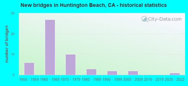
- New bridges - historical statistics
- 61950-1959
- 271960-1969
- 101970-1979
- 31980-1989
- 21990-1999
- 22000-2009
- 12020-2022

- Reconstructed bridges - Historical Statistics
- 51960-1969
- 21970-1979
- 31980-1989
- 21990-1999


- Bridge Condition - Deck
- 75.0%Good
- 3.6%Satisfactory
- 17.9%Fair
- 3.6%Poor

- Bridge Condition - Superstructure
- 78.6%Good
- 14.3%Fair
- 7.1%Poor

- Bridge Condition - Substructure
- 78.6%Good
- 17.9%Fair
- 3.6%Poor

- Bridge Condition - Channel
- 25.0%Excellent
- 70.0%Very good
- 5.0%Good

- Bridge Condition - Culverts
- 68.8%Good
- 31.3%Satisfactory
Find on map >> Show street view
Structure Number: 55 026, Location: 12-ORA-405-13.41-FNV (Lat: 33.701658, Lng: -117.950033), Route carried "on" structure: City street M034, Year Built: 1966, Status: Open, Structure Length: 12.83m (42.09ft), Average Daily Traffic: 10,000 (year 2021), Truck Traffic: 3%, Average Future Daily Traffic: 11,797 (year 2043), Design Load: HS 20+Mod, Features Intersected: ROUTE 405, Facility Carried by Structure: TALBERT AVE
Minimum Vertical Clearance: 30+ m (98+ ft), Kilometerpoint: 0.000, Lanes on structure: 4, Lanes under structure: 12, Owner: State Highway Agency, Approaching Roadway Width: 15.8m (51.8ft), Skew: 5 degrees, Material/Design: Concrete continuous, Design/Construction: Box Beam or Girders - Multiple, Number Of Spans In Main Unit: 4, Length of Maximum Span: 45.1m (148.0ft), Curb or Sidewalk Widths: Left: 0.6m (2.0ft), Right: 1.5m (4.9ft), Curb-To-Curb Width: 15.8m (51.8ft), Out-to-Out Width: 18.6m (61.0ft)
Condition: Deck: Good, Superstructure: Good, Substructure: Good, Operating Rating: 54.1 metric tons, Method Used To Determine Operating Rating: Assigned rating based on Load Factor Design (LFD) reported in metric tons, Inventory Rating: 32.4 metric tons, Method Used To Determine Inventory Rating: Assigned rating based on Load Factor Design (LFD) reported in metric tons, Structural Evaluation: Better than present minimum criteria, Deck Geometry: Meets minimum limits, Underclear: High priority of corrective action, Approach Roadway Alignment: Equal to present desirable criteria, Designated Inspection Frequency: Every 24 months, Inspection Date: August 2021, Deck Structure Type: Concrete Cast-file-Place, Wearing Surface/Protective System: Wearing Surface: Monolithic Concrete
Find on map >> Show street view
Structure Number: 55 0265, Location: 12-ORA-405-15.90-HNTB (Lat: 33.726303, Lng: -117.980675), Route carried "on" structure: City street M073, Year Built: 1966, Status: Open, Structure Length: 8.53m (27.99ft), Average Daily Traffic: 10,000 (year 2011), Truck Traffic: 3%, Average Future Daily Traffic: 11,797 (year 2038), Design Load: HS 20+Mod, Features Intersected: ROUTE 405, Facility Carried by Structure: NEWLAND ST
Minimum Vertical Clearance: 30+ m (98+ ft), Kilometerpoint: 0.000, Lanes on structure: 2, Lanes under structure: 10, Owner: State Highway Agency, Approaching Roadway Width: 8.5m (27.9ft), Skew: 4 degrees, Material/Design: Concrete continuous, Design/Construction: Box Beam or Girders - Multiple, Number Of Spans In Main Unit: 4, Length of Maximum Span: 32.0m (105.0ft), Curb or Sidewalk Widths: Left: 1.5m (4.9ft), Right: 0.6m (2.0ft), Curb-To-Curb Width: 8.5m (27.9ft), Out-to-Out Width: 11.3m (37.1ft)
Condition: Deck: Good, Superstructure: Fair, Substructure: Fair, Operating Rating: 54.1 metric tons, Method Used To Determine Operating Rating: Assigned rating based on Load Factor Design (LFD) reported in metric tons, Inventory Rating: 32.4 metric tons, Method Used To Determine Inventory Rating: Assigned rating based on Load Factor Design (LFD) reported in metric tons, Structural Evaluation: Somewhat better than minimum adequacy, Deck Geometry: Meets minimum limits, Underclear: High priority of corrective action, Approach Roadway Alignment: Equal to present desirable criteria, Designated Inspection Frequency: Every 24 months, Inspection Date: August 2021, Deck Structure Type: Concrete Cast-file-Place
Find on map >> Show street view
Structure Number: 55 0267, Location: 12-ORA-405-16.52-HNTB (Lat: 33.732861, Lng: -117.989008), Route carried "on" structure: Interstate 405, Year Built: 1965, Year Reconstructed: 1989, Status: Open, Structure Length: 8.17m (26.80ft), Average Daily Traffic: 256,000 (year 2013), Truck Traffic: 4%, Average Future Daily Traffic: 343,000 (year 2038), Design Load: HS 20+Mod, Features Intersected: ROUTE 39
Minimum Vertical Clearance: 30+ m (98+ ft), Kilometerpoint: 16.520, Lanes on structure: 14, Lanes under structure: 8, Base Highway Network: Yes (Inventory Route: 4, Subroute: 1), Owner: State Highway Agency, Approaching Roadway Width: 69.6m (228.3ft), Skew: 34 degrees, Material/Design: Concrete continuous, Design/Construction: Box Beam or Girders - Multiple, Number Of Spans In Main Unit: 4, Length of Maximum Span: 28.7m (94.2ft), Curb-To-Curb Width: 69.6m (228.3ft), Out-to-Out Width: 71.3m (233.9ft)
Condition: Deck: Satisfactory, Superstructure: Good, Substructure: Good, Operating Rating: 54.1 metric tons, Method Used To Determine Operating Rating: Assigned rating based on Load Factor Design (LFD) reported in metric tons, Inventory Rating: 32.4 metric tons, Method Used To Determine Inventory Rating: Assigned rating based on Load Factor Design (LFD) reported in metric tons, Structural Evaluation: Better than present minimum criteria, Deck Geometry: Superior to present desirable criteria, Underclear: High priority of corrective action, Approach Roadway Alignment: Equal to present desirable criteria, Designated Inspection Frequency: Every 24 months, Inspection Date: September 2021, Deck Structure Type: Concrete Cast-file-Place
Find on map >> Show street view
Structure Number: 55 0281, Location: 12-ORA-039-5.13-HNTB (Lat: 33.723028, Lng: -117.989000), Route carried "on" structure: State highway 39, Year Built: 1961, Status: Open, Structure Length: 1.07m (3.51ft), Average Daily Traffic: 72,000 (year 2009), Truck Traffic: 1%, Average Future Daily Traffic: 93,667 (year 2044), Design Load: HS 20, Features Intersected: E GARDEN GROVE CHANNEL
Minimum Vertical Clearance: 30+ m (98+ ft), Kilometerpoint: 5.130, Lanes on structure: 8, Base Highway Network: Yes (, Subroute: 1), Owner: State Highway Agency, Approaching Roadway Width: 30.2m (99.1ft), Skew: 22 degrees, Material/Design: Concrete, Design/Construction: Culvert, Number Of Spans In Main Unit: 3, Length of Maximum Span: 3.7m (12.1ft), Curb or Sidewalk Widths: Left: 0.0m, Right: 1.7m (5.6ft), Curb-To-Curb Width: 30.2m (99.1ft), Out-to-Out Width: 31.2m (102.4ft)
Condition: Channel: Very good, Culverts: Satisfactory, Operating Rating: 54.1 metric tons, Method Used To Determine Operating Rating: Field evaluation and documented engineering judgment, Inventory Rating: 32.4 metric tons, Method Used To Determine Inventory Rating: Field evaluation and documented engineering judgment, Structural Evaluation: Equal to present minimum criteria, Deck Geometry: Somewhat better than minimum adequacy, Waterway Adequacy: Equal to present desirable criteria, Approach Roadway Alignment: Equal to present desirable criteria, Designated Inspection Frequency: Every 48 months, Inspection Date: January 2022
Find on map >> Show street view
Structure Number: 55 0479, Location: 12-ORA-405-15.49-HNTB (Lat: 33.722800, Lng: -117.975000), Route carried "on" structure: Interstate 405, Year Built: 1966, Status: Open, Structure Length: 0.70m (2.30ft), Average Daily Traffic: 263,000 (year 2011), Truck Traffic: 7%, Average Future Daily Traffic: 362,000 (year 2038), Features Intersected: HEIL AVE DRAIN
Minimum Vertical Clearance: 30+ m (98+ ft), Kilometerpoint: 15.490, Lanes on structure: 12, Base Highway Network: Yes (Inventory Route: 4, Subroute: 1), Owner: State Highway Agency, Approaching Roadway Width: 45.8m (150.3ft), Skew: 34 degrees, Material/Design: Concrete, Design/Construction: Culvert, Number Of Spans In Main Unit: 3, Length of Maximum Span: 2.4m (7.9ft), Curb-To-Curb Width: 45.8m (150.3ft), Out-to-Out Width: 46.8m (153.5ft)
Condition: Channel: Very good, Culverts: Good, Operating Rating: 54.1 metric tons, Method Used To Determine Operating Rating: Field evaluation and documented engineering judgment, Inventory Rating: 32.4 metric tons, Method Used To Determine Inventory Rating: Field evaluation and documented engineering judgment, Structural Evaluation: Better than present minimum criteria, Deck Geometry: Meets minimum limits, Waterway Adequacy: Equal to present desirable criteria, Approach Roadway Alignment: Equal to present desirable criteria, Designated Inspection Frequency: Every 24 months, Inspection Date: August 2021
Find on map >> Show street view
Structure Number: 55 0658, Location: 12-ORA-001-21.82-HNTB (Lat: 33.633047, Lng: -117.960197), Route carried "on" structure: State highway 1, Year Built: 1991, Status: Open, Structure Length: 5.36m (17.59ft), Average Daily Traffic: 39,000 (year 2012), Average Future Daily Traffic: 51,653 (year 2040), Design Load: HS 20, Features Intersected: TALBERT CHANNEL
Minimum Vertical Clearance: 30+ m (98+ ft), Kilometerpoint: 21.820, Lanes on structure: 6, Base Highway Network: Yes (, Subroute: 1), Owner: State Highway Agency, Approaching Roadway Width: 31.9m (104.7ft), Skew: 30 degrees, Material/Design: Concrete continuous, Design/Construction: Slab, Number Of Spans In Main Unit: 5, Length of Maximum Span: 11.9m (39.0ft), Curb-To-Curb Width: 31.9m (104.7ft), Out-to-Out Width: 33.5m (109.9ft)
Condition: Deck: Fair, Superstructure: Fair, Substructure: Good, Channel: Very good, Operating Rating: 54.1 metric tons, Method Used To Determine Operating Rating: Assigned rating based on Load Factor Design (LFD) reported in metric tons, Inventory Rating: 32.4 metric tons, Method Used To Determine Inventory Rating: Assigned rating based on Load Factor Design (LFD) reported in metric tons, Structural Evaluation: Somewhat better than minimum adequacy, Deck Geometry: Superior to present desirable criteria, Waterway Adequacy: Equal to present desirable criteria, Approach Roadway Alignment: Equal to present desirable criteria, Designated Inspection Frequency: Every 24 months, Inspection Date: June 2021, Deck Structure Type: Concrete Cast-file-Place
Find on map >> Show street view
Structure Number: 55 1046L, Location: 12-ORA-005-33.39-SA (Lat: 33.771556, Lng: -117.870147), Route carried "on" structure: Interstate 5, Year Built: 1996, Status: Open, Structure Length: 5.02m (16.47ft), Average Daily Traffic: 183,000 (year 2016), Truck Traffic: 5%, Average Future Daily Traffic: 200,463 (year 2041), Design Load: HS 20+Mod, Features Intersected: SANTIAGO CREEK
Minimum Vertical Clearance: 30+ m (98+ ft), Kilometerpoint: 33.390, Lanes on structure: 8, Base Highway Network: Yes (, Subroute: 1), Owner: State Highway Agency, Approaching Roadway Width: 48.2m (158.1ft), Skew: 1 degrees, Material/Design: Prestressed concrete continuous, Design/Construction: Box Beam or Girders - Multiple, Number Of Spans In Main Unit: 2, Length of Maximum Span: 25.1m (82.3ft), Curb-To-Curb Width: 48.2m (158.1ft), Out-to-Out Width: 51.7m (169.6ft)
Condition: Deck: Fair, Superstructure: Good, Substructure: Good, Channel: Good, Operating Rating: 54.1 metric tons, Method Used To Determine Operating Rating: Assigned rating based on Load Factor Design (LFD) reported in metric tons, Inventory Rating: 32.4 metric tons, Method Used To Determine Inventory Rating: Assigned rating based on Load Factor Design (LFD) reported in metric tons, Structural Evaluation: Better than present minimum criteria, Deck Geometry: Superior to present desirable criteria, Waterway Adequacy: Equal to present desirable criteria, Approach Roadway Alignment: Equal to present desirable criteria, Designated Inspection Frequency: Every 24 months, Inspection Date: November 2021, Deck Structure Type: Concrete Cast-file-Place
Find on map >> Show street view
Structure Number: 55 1068, Location: 12-ORA-001-27.31 (Lat: 33.682925, Lng: -118.035128), Route carried "on" structure: State highway 1, Year Built: 2006, Status: Open, Structure Length: 12.50m (41.01ft), Average Daily Traffic: 36,000 (year 2012), Average Future Daily Traffic: 53,889 (year 2040), Design Load: HS 20+Mod, Features Intersected: TIDAL INLET CHANNEL
Minimum Vertical Clearance: 30+ m (98+ ft), Kilometerpoint: 27.310, Lanes on structure: 4, Base Highway Network: Yes (, Subroute: 1), Owner: State Highway Agency, Approaching Roadway Width: 24.3m (79.7ft), Material/Design: Concrete continuous, Design/Construction: Slab, Number Of Spans In Main Unit: 13, Length of Maximum Span: 10.0m (32.8ft), Curb or Sidewalk Widths: Left: 6.0m (19.7ft), Right: 0.0m, Curb-To-Curb Width: 24.3m (79.7ft), Out-to-Out Width: 31.9m (104.7ft)
Condition: Deck: Good, Superstructure: Good, Substructure: Good, Channel: Very good, Operating Rating: 54.1 metric tons, Method Used To Determine Operating Rating: Assigned rating based on Load Factor Design (LFD) reported in metric tons, Inventory Rating: 32.4 metric tons, Method Used To Determine Inventory Rating: Assigned rating based on Load Factor Design (LFD) reported in metric tons, Structural Evaluation: Better than present minimum criteria, Deck Geometry: Superior to present desirable criteria, Waterway Adequacy: Equal to present desirable criteria, Approach Roadway Alignment: Equal to present desirable criteria, Designated Inspection Frequency: Every 48 months, Inspection Date: June 2021, Deck Structure Type: Concrete Cast-file-Place
Find on map >> Show street view
Structure Number: 55C0074, Location: 0.2 MI E/O SPRINGDALE AV (Lat: 33.744225, Lng: -118.021978), Route carried "on" structure: City street , Year Built: 1963, Status: Open, Structure Length: 1.19m (3.90ft), Average Daily Traffic: 22,000 (year 2020), Truck Traffic: 1%, Average Future Daily Traffic: 26,368 (year 2039), Design Load: HS 20, Features Intersected: WESTMINSTER CHANNEL, Facility Carried by Structure: BOLSA AVE
Minimum Vertical Clearance: 30+ m (98+ ft), Kilometerpoint: 0.000, Lanes on structure: 7, Base Highway Network: Yes, Owner: City or Municipal Highway Agency, Approaching Roadway Width: 25.5m (83.7ft), Skew: 39 degrees, Material/Design: Concrete, Design/Construction: Culvert, Number Of Spans In Main Unit: 3, Length of Maximum Span: 3.7m (12.1ft), Curb or Sidewalk Widths: Left: 3.3m (10.8ft), Right: 0.2m (0.7ft), Curb-To-Curb Width: 25.5m (83.7ft), Out-to-Out Width: 30.8m (101.0ft)
Condition: Channel: Very good, Culverts: Good, Operating Rating: 54.1 metric tons, Method Used To Determine Operating Rating: Field evaluation and documented engineering judgment, Inventory Rating: 32.4 metric tons, Method Used To Determine Inventory Rating: Field evaluation and documented engineering judgment, Structural Evaluation: Better than present minimum criteria, Deck Geometry: High priority of corrective action, Waterway Adequacy: Superior to present desirable criteria, Approach Roadway Alignment: Equal to present desirable criteria, Designated Inspection Frequency: Every 48 months, Inspection Date: April 2020
Find on map >> Show street view
Structure Number: 55C0075, Location: 100' N/O EDINGER AVE (Lat: 33.729969, Lng: -118.041431), Route carried "on" structure: City street , Year Built: 1960, Year Reconstructed: 1972, Status: Open, Structure Length: 2.65m (8.69ft), Average Daily Traffic: 36,000 (year 2020), Truck Traffic: 1%, Average Future Daily Traffic: 32,695 (year 2039), Design Load: HS 20, Features Intersected: WESTMINSTER CHANNEL, Facility Carried by Structure: BOLSA CHICA ST
Minimum Vertical Clearance: 30+ m (98+ ft), Kilometerpoint: 0.000, Lanes on structure: 7, Base Highway Network: Yes, Owner: City or Municipal Highway Agency, Approaching Roadway Width: 26.0m (85.3ft), Skew: 30 degrees, Material/Design: Concrete continuous, Design/Construction: Slab, Number Of Spans In Main Unit: 3, Length of Maximum Span: 8.5m (27.9ft), Curb or Sidewalk Widths: Left: 1.8m (5.9ft), Right: 1.8m (5.9ft), Curb-To-Curb Width: 26.0m (85.3ft), Out-to-Out Width: 31.1m (102.0ft)
Condition: Deck: Good, Superstructure: Good, Substructure: Good, Channel: Very good, Operating Rating: 60.3 metric tons, Method Used To Determine Operating Rating: Load Factor (LF), Inventory Rating: 36.3 metric tons, Method Used To Determine Inventory Rating: Load Factor (LF), Structural Evaluation: Better than present minimum criteria, Deck Geometry: Meets minimum limits, Waterway Adequacy: Superior to present desirable criteria, Approach Roadway Alignment: Equal to present desirable criteria, Designated Inspection Frequency: Every 48 months, Inspection Date: April 2020, Deck Structure Type: Concrete Cast-file-Place, Wearing Surface/Protective System: Wearing Surface: Bituminous
Find on map >> Show street view
Structure Number: 55C009, Location: 0.3 MI. SW/O JERONIMO RD. (Lat: 33.626142, Lng: -117.693767), Route carried "on" structure: City street , Year Built: 1970, Status: Open, Structure Length: 4.79m (15.72ft), Average Daily Traffic: 54,405 (year 2011), Truck Traffic: 1%, Average Future Daily Traffic: 85,221 (year 2041), Design Load: HS 20+Mod, Features Intersected: BNSF RY,AMTRAK,METROLINK, Facility Carried by Structure: EL TORO ROAD
Minimum Vertical Clearance: 30+ m (98+ ft), Kilometerpoint: 0.000, Lanes on structure: 6, Base Highway Network: Yes, Owner: City or Municipal Highway Agency, Approaching Roadway Width: 23.2m (76.1ft), Skew: 30 degrees, Material/Design: Concrete continuous, Design/Construction: Box Beam or Girders - Multiple, Number Of Spans In Main Unit: 2, Length of Maximum Span: 25.3m (83.0ft), Curb or Sidewalk Widths: Left: 1.2m (3.9ft), Right: 1.2m (3.9ft), Curb-To-Curb Width: 23.2m (76.1ft), Out-to-Out Width: 27.4m (89.9ft)
Condition: Deck: Fair, Superstructure: Good, Substructure: Good, Operating Rating: 48.3 metric tons, Method Used To Determine Operating Rating: Load and Resistance Factor Rating (LRFR) rating reported by rating factor(RF) method using HL-93 loadings, Inventory Rating: 37.3 metric tons, Method Used To Determine Inventory Rating: Load and Resistance Factor Rating (LRFR) rating reported by rating factor(RF) method using HL-93 loadings, Structural Evaluation: Better than present minimum criteria, Deck Geometry: Meets minimum limits, Underclear: Meets minimum limits, Approach Roadway Alignment: Equal to present desirable criteria, Designated Inspection Frequency: Every 24 months, Inspection Date: September 2020, Deck Structure Type: Concrete Cast-file-Place
Find on map >> Show street view
Structure Number: 55C0096, Location: 0.1 MI N/O RTE 1 (Lat: 33.636358, Lng: -117.962906), Route carried "on" structure: City street , Year Built: 1958, Year Reconstructed: 1989, Status: Open, Structure Length: 4.60m (15.09ft), Average Daily Traffic: 14,000 (year 2020), Truck Traffic: 1%, Average Future Daily Traffic: 26,368 (year 2039), Features Intersected: TALBERT CHANNEL, Facility Carried by Structure: BROOKHURST ST
Minimum Vertical Clearance: 30+ m (98+ ft), Kilometerpoint: 0.000, Lanes on structure: 6, Base Highway Network: Yes, Owner: City or Municipal Highway Agency, Approaching Roadway Width: 31.7m (104.0ft), Material/Design: Prestressed concrete, Design/Construction: Slab, Number Of Spans In Main Unit: 5, Length of Maximum Span: 10.1m (33.1ft), Curb or Sidewalk Widths: Left: 2.1m (6.9ft), Right: 2.1m (6.9ft), Curb-To-Curb Width: 31.7m (104.0ft), Out-to-Out Width: 36.6m (120.1ft)
Condition: Deck: Good, Superstructure: Good, Substructure: Good, Channel: Very good, Operating Rating: 23.0 metric tons, Method Used To Determine Operating Rating: Load and Resistance Factor Rating (LRFR) rating reported by rating factor(RF) method using HL-93 loadings, Inventory Rating: 13.0 metric tons, Method Used To Determine Inventory Rating: Load and Resistance Factor Rating (LRFR) rating reported by rating factor(RF) method using HL-93 loadings, Structural Evaluation: High priority of corrective action, Deck Geometry: Superior to present desirable criteria, Waterway Adequacy: Superior to present desirable criteria, Approach Roadway Alignment: Equal to present desirable criteria, Designated Inspection Frequency: Every 24 months, Inspection Date: April 2020, Deck Structure Type: Concrete Precast Panels, Wearing Surface/Protective System: Wearing Surface: Bituminous
Find on map >> Show street view
Structure Number: 55C0102, Location: 0.1 MI. N/O CRESCENT AVE. (Lat: 33.841669, Lng: -117.941450), Route carried "on" structure: City street , Year Built: 1959, Year Reconstructed: 2002, Status: Open, Structure Length: 1.10m (3.61ft), Average Daily Traffic: 40,000 (year 2001), Truck Traffic: 1%, Average Future Daily Traffic: 88,398 (year 2043), Design Load: HS 20, Features Intersected: CARBON CREEK CHANNEL, Facility Carried by Structure: EUCLID STREET
Minimum Vertical Clearance: 30+ m (98+ ft), Kilometerpoint: 0.000, Lanes on structure: 7, Base Highway Network: Yes, Owner: City or Municipal Highway Agency, Approaching Roadway Width: 26.2m (86.0ft), Material/Design: Prestressed concrete, Design/Construction: Slab, Number Of Spans In Main Unit: 1, Length of Maximum Span: 10.7m (35.1ft), Curb or Sidewalk Widths: Left: 2.7m (8.9ft), Right: 2.7m (8.9ft), Curb-To-Curb Width: 26.2m (86.0ft), Out-to-Out Width: 32.2m (105.6ft)
Condition: Deck: Good, Superstructure: Good, Substructure: Good, Channel: Very good, Operating Rating: 50.2 metric tons, Method Used To Determine Operating Rating: Load Factor (LF), Inventory Rating: 32.4 metric tons, Method Used To Determine Inventory Rating: Load Factor (LF), Structural Evaluation: Better than present minimum criteria, Deck Geometry: Meets minimum limits, Waterway Adequacy: Superior to present desirable criteria, Approach Roadway Alignment: Equal to present desirable criteria, Designated Inspection Frequency: Every 48 months, Inspection Date: September 2021, Deck Structure Type: Concrete Precast Panels, Wearing Surface/Protective System: Wearing Surface: Bituminous
Find on map >> Show street view
Structure Number: 55C0103, Location: 0.15 MI E/O BROOKHURST ST (Lat: 33.650489, Lng: -117.952308), Route carried "on" structure: County highway , Year Built: 1979, Year Reconstructed: 1992, Status: Open, Structure Length: 19.40m (63.65ft), Average Daily Traffic: 30,000 (year 2010), Truck Traffic: 2%, Average Future Daily Traffic: 53,039 (year 2044), Design Load: HS 20+Mod, Features Intersected: SANTA ANA RIVER, Facility Carried by Structure: HAMILTON-VICTORIA
Minimum Vertical Clearance: 30+ m (98+ ft), Kilometerpoint: 0.000, Lanes on structure: 4, Owner: County Highway Agency, Approaching Roadway Width: 24.0m (78.7ft), Skew: 1 degrees, Material/Design: Concrete continuous, Design/Construction: Tee Beam, Number Of Spans In Main Unit: 7, Length of Maximum Span: 28.8m (94.5ft), Curb or Sidewalk Widths: Left: 1.5m (4.9ft), Right: 1.5m (4.9ft), Curb-To-Curb Width: 23.8m (78.1ft), Out-to-Out Width: 27.4m (89.9ft)
Condition: Deck: Good, Superstructure: Good, Substructure: Good, Channel: Excellent, Operating Rating: 54.1 metric tons, Method Used To Determine Operating Rating: Assigned rating based on Load Factor Design (LFD) reported in metric tons, Inventory Rating: 32.4 metric tons, Method Used To Determine Inventory Rating: Assigned rating based on Load Factor Design (LFD) reported in metric tons, Structural Evaluation: Better than present minimum criteria, Deck Geometry: Superior to present desirable criteria, Waterway Adequacy: Superior to present desirable criteria, Approach Roadway Alignment: Equal to present desirable criteria, Designated Inspection Frequency: Every 48 months, Inspection Date: January 2022, Deck Structure Type: Concrete Cast-file-Place
Find on map >> Show street view
Structure Number: 55C0109, Location: 0.2 MI W/O SPRINGDALE AVE (Lat: 33.715258, Lng: -118.027147), Route carried "on" structure: City street , Year Built: 1960, Year Reconstructed: 1967, Status: Open, Structure Length: 4.33m (14.21ft), Average Daily Traffic: 31,200 (year 2009), Truck Traffic: 1%, Average Future Daily Traffic: 32,914 (year 2036), Design Load: HS 20, Features Intersected: E GARDEN GRO-WBURG CH, Facility Carried by Structure: WARNER AVE
Minimum Vertical Clearance: 30+ m (98+ ft), Kilometerpoint: 0.000, Lanes on structure: 6, Base Highway Network: Yes, Owner: City or Municipal Highway Agency, Approaching Roadway Width: 27.2m (89.2ft), Skew: 29 degrees, Material/Design: Prestressed concrete, Design/Construction: Slab, Number Of Spans In Main Unit: 4, Length of Maximum Span: 10.4m (34.1ft), Curb or Sidewalk Widths: Left: 1.8m (5.9ft), Right: 1.8m (5.9ft), Curb-To-Curb Width: 27.2m (89.2ft), Out-to-Out Width: 35.4m (116.1ft)
Condition: Deck: Good, Superstructure: Good, Substructure: Good, Channel: Very good, Operating Rating: 49.2 metric tons, Method Used To Determine Operating Rating: Load Factor (LF), Inventory Rating: 32.4 metric tons, Method Used To Determine Inventory Rating: Load Factor (LF), Structural Evaluation: Better than present minimum criteria, Deck Geometry: Better than present minimum criteria, Waterway Adequacy: Superior to present desirable criteria, Approach Roadway Alignment: Equal to present desirable criteria, Designated Inspection Frequency: Every 48 months, Inspection Date: April 2018, Deck Structure Type: Concrete Precast Panels, Wearing Surface/Protective System: Wearing Surface: Bituminous
Find on map >> Show street view
Structure Number: 55C0134, Location: 0.1 MI N/O WARNER AVE (Lat: 33.717378, Lng: -118.006469), Route carried "on" structure: City street , Year Built: 1959, Year Reconstructed: 1970, Status: Open, Structure Length: 2.04m (6.69ft), Average Daily Traffic: 35,520 (year 2020), Truck Traffic: 1%, Average Future Daily Traffic: 39,025 (year 2039), Design Load: H 15, Features Intersected: E GARDEN GRO-WBURG CH, Facility Carried by Structure: GOLDEN WEST STREET
Minimum Vertical Clearance: 30+ m (98+ ft), Kilometerpoint: 0.000, Lanes on structure: 7, Base Highway Network: Yes, Owner: City or Municipal Highway Agency, Approaching Roadway Width: 25.3m (83.0ft), Material/Design: Prestressed concrete, Design/Construction: Slab, Number Of Spans In Main Unit: 2, Length of Maximum Span: 10.1m (33.1ft), Curb or Sidewalk Widths: Left: 1.7m (5.6ft), Right: 1.7m (5.6ft), Curb-To-Curb Width: 25.3m (83.0ft), Out-to-Out Width: 29.6m (97.1ft)
Condition: Deck: Good, Superstructure: Good, Substructure: Good, Channel: Very good, Operating Rating: 71.6 metric tons, Method Used To Determine Operating Rating: Load Factor (LF), Inventory Rating: 32.4 metric tons, Method Used To Determine Inventory Rating: Load Factor (LF), Structural Evaluation: Better than present minimum criteria, Deck Geometry: High priority of corrective action, Waterway Adequacy: Superior to present desirable criteria, Approach Roadway Alignment: Equal to present desirable criteria, Designated Inspection Frequency: Every 48 months, Inspection Date: April 2020, Deck Structure Type: Concrete Precast Panels, Wearing Surface/Protective System: Wearing Surface: Bituminous
Find on map >> Show street view
Structure Number: 55C0136, Location: 0.25 MI E/O MAGNOLIA ST (Lat: 33.686658, Lng: -117.967150), Route carried "on" structure: City street , Year Built: 1970, Status: Open, Structure Length: 1.07m (3.51ft), Average Daily Traffic: 17,420 (year 2020), Truck Traffic: 1%, Average Future Daily Traffic: 20,144 (year 2039), Features Intersected: TALBERT CHANNEL, Facility Carried by Structure: GARFIELD AVENUE
Minimum Vertical Clearance: 30+ m (98+ ft), Kilometerpoint: 0.000, Lanes on structure: 4, Base Highway Network: Yes, Owner: City or Municipal Highway Agency, Approaching Roadway Width: 21.0m (68.9ft), Skew: 30 degrees, Material/Design: Concrete, Design/Construction: Culvert, Number Of Spans In Main Unit: 4, Length of Maximum Span: 2.4m (7.9ft), Curb or Sidewalk Widths: Left: 2.4m (7.9ft), Right: 2.4m (7.9ft), Curb-To-Curb Width: 21.0m (68.9ft), Out-to-Out Width: 30.8m (101.0ft)
Condition: Channel: Very good, Culverts: Good, Operating Rating: 40.5 metric tons, Method Used To Determine Operating Rating: Field evaluation and documented engineering judgment, Inventory Rating: 24.3 metric tons, Method Used To Determine Inventory Rating: Field evaluation and documented engineering judgment, Structural Evaluation: Equal to present minimum criteria, Deck Geometry: Superior to present desirable criteria, Waterway Adequacy: Equal to present desirable criteria, Approach Roadway Alignment: Equal to present desirable criteria, Designated Inspection Frequency: Every 24 months, Inspection Date: April 2020
Find on map >> Show street view
Structure Number: 55C0137, Location: 0.2 MI W/O BROOKHURST ST (Lat: 33.686711, Lng: -117.958486), Route carried "on" structure: City street , Year Built: 1965, Status: Open, Structure Length: 0.98m (3.22ft), Average Daily Traffic: 14,700 (year 2020), Truck Traffic: 1%, Average Future Daily Traffic: 15,900 (year 2039), Features Intersected: FOUNTAIN VALLEY CHANNEL, Facility Carried by Structure: GARFIELD AVENUE
Minimum Vertical Clearance: 30+ m (98+ ft), Kilometerpoint: 0.000, Lanes on structure: 5, Base Highway Network: Yes, Owner: City or Municipal Highway Agency, Approaching Roadway Width: 25.3m (83.0ft), Material/Design: Concrete, Design/Construction: Culvert, Number Of Spans In Main Unit: 3, Length of Maximum Span: 3.0m (9.8ft), Curb or Sidewalk Widths: Left: 2.4m (7.9ft), Right: 2.5m (8.2ft), Curb-To-Curb Width: 25.3m (83.0ft), Out-to-Out Width: 30.8m (101.0ft)
Condition: Channel: Very good, Culverts: Good, Operating Rating: 40.5 metric tons, Method Used To Determine Operating Rating: Field evaluation and documented engineering judgment, Inventory Rating: 24.3 metric tons, Method Used To Determine Inventory Rating: Field evaluation and documented engineering judgment, Structural Evaluation: Equal to present minimum criteria, Deck Geometry: Superior to present desirable criteria, Waterway Adequacy: Equal to present desirable criteria, Approach Roadway Alignment: Equal to present desirable criteria, Designated Inspection Frequency: Every 24 months, Inspection Date: April 2020, Deck Structure Type: Concrete Cast-file-Place, Wearing Surface/Protective System: Wearing Surface: Bituminous
Find on map >> Show street view
Structure Number: 55C0138, Location: 0.25 MI E/O MAGNOLIA ST (Lat: 33.672139, Lng: -117.967039), Route carried "on" structure: City street , Year Built: 1959, Year Reconstructed: 1972, Status: Open, Structure Length: 2.53m (8.30ft), Average Daily Traffic: 32,000 (year 2020), Truck Traffic: 1%, Average Future Daily Traffic: 38,500 (year 2039), Features Intersected: TALBERT CHANNEL, Facility Carried by Structure: ADAMS AVENUE
Minimum Vertical Clearance: 30+ m (98+ ft), Kilometerpoint: 0.000, Lanes on structure: 6, Base Highway Network: Yes, Owner: City or Municipal Highway Agency, Approaching Roadway Width: 24.8m (81.4ft), Skew: 30 degrees, Material/Design: Concrete, Design/Construction: Culvert, Number Of Spans In Main Unit: 8, Length of Maximum Span: 3.0m (9.8ft), Curb or Sidewalk Widths: Left: 1.6m (5.2ft), Right: 1.6m (5.2ft), Curb-To-Curb Width: 24.8m (81.4ft), Out-to-Out Width: 32.9m (107.9ft)
Condition: Channel: Very good, Culverts: Good, Operating Rating: 40.5 metric tons, Method Used To Determine Operating Rating: Field evaluation and documented engineering judgment, Inventory Rating: 24.3 metric tons, Method Used To Determine Inventory Rating: Field evaluation and documented engineering judgment, Structural Evaluation: Equal to present minimum criteria, Deck Geometry: Somewhat better than minimum adequacy, Waterway Adequacy: Equal to present desirable criteria, Approach Roadway Alignment: Equal to present desirable criteria, Designated Inspection Frequency: Every 24 months, Inspection Date: April 2020, Deck Structure Type: Concrete Cast-file-Place, Wearing Surface/Protective System: Wearing Surface: Bituminous
Find on map >> Show street view
Structure Number: 55C0156, Location: 0.4 MI S/O EDINGER AVE (Lat: 33.724789, Lng: -118.041328), Route carried "on" structure: City street , Year Built: 1966, Status: Open, Structure Length: 0.76m (2.49ft), Average Daily Traffic: 29,000 (year 2018), Truck Traffic: 1%, Average Future Daily Traffic: 31,640 (year 2040), Design Load: HS 15, Features Intersected: SUNSET CHANNEL, Facility Carried by Structure: BOLSA CHICA ST
Minimum Vertical Clearance: 30+ m (98+ ft), Kilometerpoint: 0.000, Lanes on structure: 6, Base Highway Network: Yes, Owner: City or Municipal Highway Agency, Approaching Roadway Width: 27.7m (90.9ft), Skew: 39 degrees, Material/Design: Concrete, Design/Construction: Culvert, Number Of Spans In Main Unit: 2, Length of Maximum Span: 2.4m (7.9ft), Curb or Sidewalk Widths: Left: 1.8m (5.9ft), Right: 1.8m (5.9ft), Curb-To-Curb Width: 27.7m (90.9ft), Out-to-Out Width: 34.4m (112.9ft)
Condition: Channel: Excellent, Culverts: Good, Operating Rating: 40.5 metric tons, Method Used To Determine Operating Rating: Field evaluation and documented engineering judgment, Inventory Rating: 24.3 metric tons, Method Used To Determine Inventory Rating: Field evaluation and documented engineering judgment, Structural Evaluation: Equal to present minimum criteria, Deck Geometry: Equal to present desirable criteria, Waterway Adequacy: Superior to present desirable criteria, Approach Roadway Alignment: Equal to present desirable criteria, Designated Inspection Frequency: Every 24 months, Inspection Date: April 2020
Find on map >> Show street view
Structure Number: 55C025, Location: 0.1 M S/O BALL RD (Lat: 33.815192, Lng: -118.054372), Route carried "on" structure: City street , Year Built: 1973, Status: Open, Structure Length: 2.13m (6.99ft), Average Daily Traffic: 6,900 (year 2017), Truck Traffic: 1%, Average Future Daily Traffic: 18,984 (year 2040), Design Load: HS 20, Features Intersected: CARBON CREEK CHANNEL, Facility Carried by Structure: DENNI STREET
Minimum Vertical Clearance: 30+ m (98+ ft), Kilometerpoint: 0.000, Lanes on structure: 4, Owner: City or Municipal Highway Agency, Approaching Roadway Width: 16.5m (54.1ft), Material/Design: Prestressed concrete, Design/Construction: Slab, Number Of Spans In Main Unit: 1, Length of Maximum Span: 21.0m (68.9ft), Curb or Sidewalk Widths: Left: 1.5m (4.9ft), Right: 1.5m (4.9ft), Curb-To-Curb Width: 16.5m (54.1ft), Out-to-Out Width: 19.5m (64.0ft)
Condition: Deck: Good, Superstructure: Good, Substructure: Good, Channel: Excellent, Operating Rating: 67.7 metric tons, Method Used To Determine Operating Rating: Load Factor (LF), Inventory Rating: 32.4 metric tons, Method Used To Determine Inventory Rating: Load Factor (LF), Structural Evaluation: Better than present minimum criteria, Deck Geometry: Meets minimum limits, Waterway Adequacy: Superior to present desirable criteria, Approach Roadway Alignment: Equal to present desirable criteria, Designated Inspection Frequency: Every 48 months, Inspection Date: May 2021, Deck Structure Type: Concrete Precast Panels, Wearing Surface/Protective System: Wearing Surface: Bituminous
Find on map >> Show street view
Structure Number: 55C0258, Location: 0.4 MI E/O ADMIRALTY DR (Lat: 33.718686, Lng: -118.067828), Route carried "on" structure: City street , Year Built: 1963, Status: Open, Structure Length: 5.33m (17.49ft), Average Daily Traffic: 900 (year 2018), Truck Traffic: 1%, Average Future Daily Traffic: 1,066 (year 2038), Design Load: H 15, Features Intersected: SHELTER CHANNEL, Facility Carried by Structure: GILBERT DR
Minimum Vertical Clearance: 30+ m (98+ ft), Kilometerpoint: 0.000, Lanes on structure: 2, Owner: City or Municipal Highway Agency, Approaching Roadway Width: 12.2m (40.0ft), Skew: 2 degrees, Material/Design: Steel continuous, Design/Construction: Stringer/Multi-beam, Number Of Spans In Main Unit: 3, Length of Maximum Span: 20.4m (66.9ft), Curb or Sidewalk Widths: Left: 1.5m (4.9ft), Right: 0.6m (2.0ft), Curb-To-Curb Width: 7.9m (25.9ft), Out-to-Out Width: 10.7m (35.1ft)
Condition: Deck: Good, Superstructure: Fair, Substructure: Fair, Channel: Excellent, Operating Rating: 28.5 metric tons, Method Used To Determine Operating Rating: Load and Resistance Factor Rating (LRFR) rating reported by rating factor(RF) method using HL-93 loadings, Inventory Rating: 22.0 metric tons, Method Used To Determine Inventory Rating: Load and Resistance Factor Rating (LRFR) rating reported by rating factor(RF) method using HL-93 loadings, Structural Evaluation: Somewhat better than minimum adequacy, Deck Geometry: Somewhat better than minimum adequacy, Waterway Adequacy: Superior to present desirable criteria, Approach Roadway Alignment: Equal to present desirable criteria, Designated Inspection Frequency: Every 24 months, Underwater Inspection Frequency: Every 60 months, Inspection Date: April 2020, Underwater Inspection Date: Febuary 2020, Deck Structure Type: Concrete Cast-file-Place, Wearing Surface/Protective System: Wearing Surface: Bituminous
Find on map >> Show street view
Structure Number: 55C0259, Location: 0.3 MI W/O SAYBROOK LN (Lat: 33.716567, Lng: -118.059019), Route carried "on" structure: City street , Year Built: 1965, Year Reconstructed: 1995, Status: Open, Structure Length: 4.75m (15.58ft), Average Daily Traffic: 2,000 (year 2018), Truck Traffic: 1%, Average Future Daily Traffic: 2,109 (year 2041), Design Load: H 15, Features Intersected: WEATHERLY CHANNEL, Facility Carried by Structure: DAVENPORT DR
Minimum Vertical Clearance: 30+ m (98+ ft), Kilometerpoint: 0.000, Lanes on structure: 2, Owner: City or Municipal Highway Agency, Approaching Roadway Width: 12.2m (40.0ft), Material/Design: Steel, Design/Construction: Stringer/Multi-beam, Number Of Spans In Main Unit: 3, Length of Maximum Span: 15.2m (49.9ft), Curb or Sidewalk Widths: Left: 1.5m (4.9ft), Right: 0.6m (2.0ft), Curb-To-Curb Width: 7.9m (25.9ft), Out-to-Out Width: 10.7m (35.1ft)
Condition: Deck: Poor, Superstructure: Poor, Substructure: Poor, Channel: Excellent, Operating Rating: 49.6 metric tons, Method Used To Determine Operating Rating: Load and Resistance Factor Rating (LRFR) rating reported by rating factor(RF) method using HL-93 loadings, Inventory Rating: 38.2 metric tons, Method Used To Determine Inventory Rating: Load and Resistance Factor Rating (LRFR) rating reported by rating factor(RF) method using HL-93 loadings, Structural Evaluation: Meets minimum limits, Deck Geometry: Meets minimum limits, Waterway Adequacy: Superior to present desirable criteria, Approach Roadway Alignment: Equal to present desirable criteria, Length Of Structure Improvement: 4.75m (15.58ft), Designated Inspection Frequency: Every 24 months, Underwater Inspection Frequency: Every 60 months, Inspection Date: April 2020, Underwater Inspection Date: Febuary 2020, Bridge Improvement Cost: $1,122,000, Roadway Improvement Cost: $224,000, Total Project Cost: $1,885,000 ( Estimate for 2019), Deck Structure Type: Concrete Cast-file-Place
Find on map >> Show street view
Structure Number: 55C0282, Location: 0.1 MI NE/O PAC COAST HWY (Lat: 33.721358, Lng: -118.072311), Route carried "on" structure: City street , Year Built: 1963, Status: Open, Structure Length: 4.79m (15.72ft), Average Daily Traffic: 2,000 (year 2020), Truck Traffic: 1%, Average Future Daily Traffic: 2,130 (year 2041), Features Intersected: QUEEN ELIZABETH PASSAGE, Facility Carried by Structure: ADMIRALTY DRIVE
Minimum Vertical Clearance: 30+ m (98+ ft), Kilometerpoint: 0.000, Lanes on structure: 2, Owner: City or Municipal Highway Agency, Approaching Roadway Width: 12.2m (40.0ft), Material/Design: Steel continuous, Design/Construction: Stringer/Multi-beam, Number Of Spans In Main Unit: 3, Length of Maximum Span: 18.3m (60.0ft), Curb or Sidewalk Widths: Left: 1.5m (4.9ft), Right: 1.5m (4.9ft), Curb-To-Curb Width: 12.2m (40.0ft), Out-to-Out Width: 15.8m (51.8ft)
Condition: Deck: Fair, Superstructure: Fair, Substructure: Good, Channel: Excellent, Operating Rating: 51.2 metric tons, Method Used To Determine Operating Rating: Load and Resistance Factor Rating (LRFR) rating reported by rating factor(RF) method using HL-93 loadings, Inventory Rating: 39.5 metric tons, Method Used To Determine Inventory Rating: Load and Resistance Factor Rating (LRFR) rating reported by rating factor(RF) method using HL-93 loadings, Structural Evaluation: Somewhat better than minimum adequacy, Deck Geometry: Better than present minimum criteria, Waterway Adequacy: Superior to present desirable criteria, Approach Roadway Alignment: Equal to present minimum criteria, Designated Inspection Frequency: Every 24 months, Underwater Inspection Frequency: Every 60 months, Inspection Date: April 2020, Underwater Inspection Date: Febuary 2020, Deck Structure Type: Concrete Cast-file-Place
Find on map >> Show street view
Structure Number: 55C0284, Location: 0.1 MI W/O SAYBROOK LN (Lat: 33.724989, Lng: -118.057375), Route carried "on" structure: City street , Year Built: 1963, Status: Open, Structure Length: 4.75m (15.58ft), Average Daily Traffic: 3,000 (year 2020), Truck Traffic: 1%, Average Future Daily Traffic: 3,165 (year 2041), Design Load: HS 20, Features Intersected: SHORT CHANNEL, Facility Carried by Structure: HUMBOLDT DRIVE
Minimum Vertical Clearance: 30+ m (98+ ft), Kilometerpoint: 0.000, Lanes on structure: 2, Owner: City or Municipal Highway Agency, Approaching Roadway Width: 12.2m (40.0ft), Material/Design: Steel, Design/Construction: Stringer/Multi-beam, Number Of Spans In Main Unit: 3, Length of Maximum Span: 15.5m (50.9ft), Curb or Sidewalk Widths: Left: 1.5m (4.9ft), Right: 0.6m (2.0ft), Curb-To-Curb Width: 7.9m (25.9ft), Out-to-Out Width: 10.7m (35.1ft)
Condition: Deck: Fair, Superstructure: Poor, Substructure: Fair, Channel: Excellent, Operating Rating: 49.2 metric tons, Method Used To Determine Operating Rating: Load Factor (LF), Inventory Rating: 29.5 metric tons, Method Used To Determine Inventory Rating: Load Factor (LF), Structural Evaluation: Meets minimum limits, Deck Geometry: High priority of corrective action, Waterway Adequacy: Superior to present desirable criteria, Approach Roadway Alignment: Equal to present desirable criteria, Length Of Structure Improvement: 4.75m (15.58ft), Designated Inspection Frequency: Every 24 months, Underwater Inspection Frequency: Every 60 months, Inspection Date: April 2020, Underwater Inspection Date: Febuary 2020, Bridge Improvement Cost: $1,168,000, Roadway Improvement Cost: $233,000, Total Project Cost: $1,962,000 ( Estimate for 2017), Deck Structure Type: Concrete Cast-file-Place
Find on map >> Show street view
Structure Number: 55C0344, Location: 0.5 MI E/O BROOKHURST ST (Lat: 33.672317, Lng: -117.946094), Route carried "on" structure: County highway , Year Built: 1977, Status: Open, Structure Length: 16.46m (54.00ft), Average Daily Traffic: 39,000 (year 2019), Truck Traffic: 2%, Average Future Daily Traffic: 90,704 (year 2039), Design Load: HS 20, Features Intersected: SANTA ANA RIVER CHANNEL, Facility Carried by Structure: ADAMS AVENUE
Minimum Vertical Clearance: 30+ m (98+ ft), Kilometerpoint: 0.000, Lanes on structure: 6, Base Highway Network: Yes, Owner: County Highway Agency, Approaching Roadway Width: 24.4m (80.1ft), Skew: 31 degrees, Material/Design: Prestressed concrete continuous, Design/Construction: Box Beam or Girders - Multiple, Number Of Spans In Main Unit: 5, Length of Maximum Span: 36.0m (118.1ft), Curb or Sidewalk Widths: Left: 1.2m (3.9ft), Right: 1.2m (3.9ft), Curb-To-Curb Width: 24.4m (80.1ft), Out-to-Out Width: 28.7m (94.2ft)
Condition: Deck: Good, Superstructure: Good, Substructure: Good, Channel: Very good, Operating Rating: 70.3 metric tons, Method Used To Determine Operating Rating: Load Factor (LF), Inventory Rating: 32.4 metric tons, Method Used To Determine Inventory Rating: Load Factor (LF), Structural Evaluation: Better than present minimum criteria, Deck Geometry: Somewhat better than minimum adequacy, Waterway Adequacy: Equal to present desirable criteria, Approach Roadway Alignment: Equal to present desirable criteria, Designated Inspection Frequency: Every 24 months, Inspection Date: January 2022, Deck Structure Type: Concrete Cast-file-Place
Find on map >> Show street view
Structure Number: 55C0375, Location: 0.25 MI W/O BUSHARD ST (Lat: 33.643150, Lng: -117.966642), Route carried "on" structure: City street , Year Built: 1959, Year Reconstructed: 1976, Status: Open, Structure Length: 2.41m (7.91ft), Average Daily Traffic: 3,000 (year 2018), Truck Traffic: 1%, Average Future Daily Traffic: 8,437 (year 2040), Design Load: HS 20, Features Intersected: TALBERT CHANNEL, Facility Carried by Structure: BANNING AVENUE
Minimum Vertical Clearance: 30+ m (98+ ft), Kilometerpoint: 0.000, Lanes on structure: 2, Owner: City or Municipal Highway Agency, Approaching Roadway Width: 19.5m (64.0ft), Material/Design: Concrete, Design/Construction: Culvert, Number Of Spans In Main Unit: 8, Length of Maximum Span: 2.7m (8.9ft), Curb or Sidewalk Widths: Left: 2.3m (7.5ft), Right: 2.1m (6.9ft), Curb-To-Curb Width: 19.5m (64.0ft), Out-to-Out Width: 24.4m (80.1ft)
Condition: Channel: Very good, Culverts: Good, Operating Rating: 40.5 metric tons, Method Used To Determine Operating Rating: Field evaluation and documented engineering judgment, Inventory Rating: 24.3 metric tons, Method Used To Determine Inventory Rating: Field evaluation and documented engineering judgment, Structural Evaluation: Equal to present minimum criteria, Deck Geometry: Superior to present desirable criteria, Waterway Adequacy: Superior to present desirable criteria, Approach Roadway Alignment: Equal to present desirable criteria, Designated Inspection Frequency: Every 24 months, Inspection Date: April 2020, Deck Structure Type: Concrete Cast-file-Place, Wearing Surface/Protective System: Wearing Surface: Bituminous
Find on map >> Show street view
Structure Number: 55C0376, Location: 0.25 MI W/O BUSHARD ST (Lat: 33.650375, Lng: -117.966914), Route carried "on" structure: City street , Year Built: 1976, Status: Open, Structure Length: 2.71m (8.89ft), Average Daily Traffic: 12,000 (year 2020), Truck Traffic: 2%, Average Future Daily Traffic: 17,929 (year 2040), Design Load: HS 20, Features Intersected: TALBERT CHANNEL, Facility Carried by Structure: HAMILTON AVENUE
Minimum Vertical Clearance: 30+ m (98+ ft), Kilometerpoint: 0.000, Lanes on structure: 5, Base Highway Network: Yes, Owner: City or Municipal Highway Agency, Approaching Roadway Width: 22.6m (74.1ft), Material/Design: Concrete, Design/Construction: Culvert, Number Of Spans In Main Unit: 8, Length of Maximum Span: 3.0m (9.8ft), Curb or Sidewalk Widths: Left: 3.0m (9.8ft), Right: 2.2m (7.2ft), Curb-To-Curb Width: 23.8m (78.1ft), Out-to-Out Width: 30.5m (100.1ft)
Condition: Channel: Very good, Culverts: Satisfactory, Operating Rating: 54.1 metric tons, Method Used To Determine Operating Rating: Field evaluation and documented engineering judgment, Inventory Rating: 32.4 metric tons, Method Used To Determine Inventory Rating: Field evaluation and documented engineering judgment, Structural Evaluation: Equal to present minimum criteria, Deck Geometry: Better than present minimum criteria, Waterway Adequacy: Superior to present desirable criteria, Approach Roadway Alignment: Equal to present desirable criteria, Designated Inspection Frequency: Every 48 months, Inspection Date: April 2020, Deck Structure Type: Concrete Cast-file-Place, Wearing Surface/Protective System: Wearing Surface: Bituminous
Find on map >> Show street view
Structure Number: 55C0377, Location: 0.25 MI W/O BUSHARD ST (Lat: 33.657628, Lng: -117.966844), Route carried "on" structure: City street , Year Built: 1970, Status: Open, Structure Length: 2.71m (8.89ft), Average Daily Traffic: 15,000 (year 2020), Truck Traffic: 1%, Average Future Daily Traffic: 14,766 (year 2040), Design Load: HS 20, Features Intersected: TALBERT CHANNEL, Facility Carried by Structure: ATLANTA AVENUE
Minimum Vertical Clearance: 30+ m (98+ ft), Kilometerpoint: 0.000, Lanes on structure: 4, Owner: City or Municipal Highway Agency, Approaching Roadway Width: 25.6m (84.0ft), Material/Design: Concrete, Design/Construction: Culvert, Number Of Spans In Main Unit: 8, Length of Maximum Span: 3.0m (9.8ft), Curb or Sidewalk Widths: Left: 2.3m (7.5ft), Right: 2.3m (7.5ft), Curb-To-Curb Width: 25.6m (84.0ft), Out-to-Out Width: 30.5m (100.1ft)
Condition: Channel: Very good, Culverts: Satisfactory, Operating Rating: 54.1 metric tons, Method Used To Determine Operating Rating: Field evaluation and documented engineering judgment, Inventory Rating: 32.4 metric tons, Method Used To Determine Inventory Rating: Field evaluation and documented engineering judgment, Structural Evaluation: Equal to present minimum criteria, Deck Geometry: Superior to present desirable criteria, Waterway Adequacy: Superior to present desirable criteria, Approach Roadway Alignment: Equal to present desirable criteria, Designated Inspection Frequency: Every 48 months, Inspection Date: April 2020, Deck Structure Type: Concrete Cast-file-Place, Wearing Surface/Protective System: Wearing Surface: Bituminous
Find on map >> Show street view
Structure Number: 55C0378, Location: 0.25 MI W/O BUSHARD ST (Lat: 33.664919, Lng: -117.966942), Route carried "on" structure: City street , Year Built: 1970, Status: Open, Structure Length: 2.65m (8.69ft), Average Daily Traffic: 8,000 (year 2018), Truck Traffic: 1%, Average Future Daily Traffic: 15,820 (year 2040), Design Load: HS 20, Features Intersected: TALBERT CHANNEL, Facility Carried by Structure: INDIANAPOLIS AVENU
Minimum Vertical Clearance: 30+ m (98+ ft), Kilometerpoint: 0.000, Lanes on structure: 3, Owner: City or Municipal Highway Agency, Approaching Roadway Width: 19.5m (64.0ft), Material/Design: Concrete, Design/Construction: Culvert, Number Of Spans In Main Unit: 8, Length of Maximum Span: 3.0m (9.8ft), Curb or Sidewalk Widths: Left: 1.7m (5.6ft), Right: 1.7m (5.6ft), Curb-To-Curb Width: 19.5m (64.0ft), Out-to-Out Width: 26.5m (86.9ft)
Condition: Channel: Very good, Culverts: Satisfactory, Operating Rating: 40.5 metric tons, Method Used To Determine Operating Rating: Field evaluation and documented engineering judgment, Inventory Rating: 24.3 metric tons, Method Used To Determine Inventory Rating: Field evaluation and documented engineering judgment, Structural Evaluation: Equal to present minimum criteria, Deck Geometry: Superior to present desirable criteria, Waterway Adequacy: Equal to present desirable criteria, Approach Roadway Alignment: Equal to present desirable criteria, Designated Inspection Frequency: Every 24 months, Inspection Date: April 2020, Deck Structure Type: Concrete Cast-file-Place, Wearing Surface/Protective System: Wearing Surface: Bituminous
Find on map >> Show street view
Structure Number: 55C0388, Location: 0.2 MI N/O RTE 1 (Lat: 33.642256, Lng: -117.972075), Route carried "on" structure: City street , Year Built: 1973, Status: Open, Structure Length: 2.74m (8.99ft), Average Daily Traffic: 9,000 (year 2018), Truck Traffic: 1%, Average Future Daily Traffic: 10,617 (year 2040), Design Load: HS 20, Features Intersected: HUNTINGTON BEACH CHANNEL, Facility Carried by Structure: MAGNOLIA ST
Minimum Vertical Clearance: 30+ m (98+ ft), Kilometerpoint: 0.000, Lanes on structure: 4, Base Highway Network: Yes, Owner: City or Municipal Highway Agency, Approaching Roadway Width: 25.6m (84.0ft), Material/Design: Concrete, Design/Construction: Slab, Number Of Spans In Main Unit: 3, Length of Maximum Span: 10.7m (35.1ft), Curb or Sidewalk Widths: Left: 2.1m (6.9ft), Right: 2.1m (6.9ft), Curb-To-Curb Width: 25.6m (84.0ft), Out-to-Out Width: 30.5m (100.1ft)
Condition: Deck: Good, Superstructure: Good, Substructure: Fair, Channel: Excellent, Operating Rating: 91.4 metric tons, Method Used To Determine Operating Rating: Load Factor (LF), Inventory Rating: 55.1 metric tons, Method Used To Determine Inventory Rating: Load Factor (LF), Structural Evaluation: Somewhat better than minimum adequacy, Deck Geometry: Superior to present desirable criteria, Waterway Adequacy: Superior to present desirable criteria, Approach Roadway Alignment: Equal to present desirable criteria, Designated Inspection Frequency: Every 24 months, Inspection Date: April 2020, Deck Structure Type: Concrete Cast-file-Place, Wearing Surface/Protective System: Wearing Surface: Bituminous
Find on map >> Show street view
Structure Number: 55C0389, Location: 0.1 MI E/O RTE 39 (Lat: 33.657533, Lng: -117.986736), Route carried "on" structure: City street , Year Built: 1966, Status: Open, Structure Length: 1.87m (6.14ft), Average Daily Traffic: 18,000 (year 2015), Truck Traffic: 1%, Average Future Daily Traffic: 12,657 (year 2037), Features Intersected: HUNTINGTON BEACH CHANNEL, Facility Carried by Structure: ATLANTA AVENUE
Minimum Vertical Clearance: 30+ m (98+ ft), Kilometerpoint: 0.000, Lanes on structure: 5, Owner: City or Municipal Highway Agency, Approaching Roadway Width: 18.0m (59.1ft), Material/Design: Concrete, Design/Construction: Culvert, Number Of Spans In Main Unit: 4, Length of Maximum Span: 4.3m (14.1ft), Curb or Sidewalk Widths: Left: 1.6m (5.2ft), Right: 1.6m (5.2ft), Curb-To-Curb Width: 21.3m (69.9ft), Out-to-Out Width: 25.0m (82.0ft)
Condition: Channel: Very good, Culverts: Good, Operating Rating: 54.1 metric tons, Method Used To Determine Operating Rating: Field evaluation and documented engineering judgment, Inventory Rating: 32.4 metric tons, Method Used To Determine Inventory Rating: Field evaluation and documented engineering judgment, Structural Evaluation: Better than present minimum criteria, Deck Geometry: Somewhat better than minimum adequacy, Waterway Adequacy: Superior to present desirable criteria, Approach Roadway Alignment: Equal to present desirable criteria, Designated Inspection Frequency: Every 48 months, Inspection Date: May 2018, Deck Structure Type: Concrete Cast-file-Place, Wearing Surface/Protective System: Wearing Surface: Bituminous
Find on map >> Show street view
Structure Number: 55C0417, Location: 0.2 MI E/O ROUTE 1 (Lat: 33.711567, Lng: -118.060447), Route carried "on" structure: City street , Year Built: 1981, Status: Open, Structure Length: 2.74m (8.99ft), Average Daily Traffic: 24,000 (year 2018), Truck Traffic: 1%, Average Future Daily Traffic: 29,729 (year 2040), Design Load: HS 20, Features Intersected: BOLSA CHICA BEACH CHANEL, Facility Carried by Structure: WARNER AVENUE
Minimum Vertical Clearance: 30+ m (98+ ft), Kilometerpoint: 0.000, Lanes on structure: 4, Base Highway Network: Yes, Owner: City or Municipal Highway Agency, Approaching Roadway Width: 19.8m (65.0ft), Material/Design: Prestressed concrete, Design/Construction: Slab, Number Of Spans In Main Unit: 3, Length of Maximum Span: 9.1m (29.9ft), Curb or Sidewalk Widths: Left: 2.1m (6.9ft), Right: 0.0m, Curb-To-Curb Width: 21.9m (71.9ft), Out-to-Out Width: 24.7m (81.0ft)
Condition: Deck: Good, Superstructure: Good, Substructure: Good, Channel: Excellent, Operating Rating: 56.1 metric tons, Method Used To Determine Operating Rating: Load Factor (LF), Inventory Rating: 32.4 metric tons, Method Used To Determine Inventory Rating: Load Factor (LF), Structural Evaluation: Better than present minimum criteria, Deck Geometry: Superior to present desirable criteria, Waterway Adequacy: Superior to present desirable criteria, Approach Roadway Alignment: Equal to present desirable criteria, Designated Inspection Frequency: Every 48 months, Underwater Inspection Frequency: Every 60 months, Inspection Date: April 2018, Underwater Inspection Date: Febuary 2020, Deck Structure Type: Concrete Precast Panels, Wearing Surface/Protective System: Wearing Surface: Bituminous
Find on map >> Show street view
Structure Number: 55C0428, Location: 0.1 MI N/O WARNER AVE (Lat: 33.717175, Lng: -118.023842), Route carried "on" structure: City street , Year Built: 1960, Year Reconstructed: 1969, Status: Open, Structure Length: 4.05m (13.29ft), Average Daily Traffic: 18,000 (year 2018), Truck Traffic: 1%, Average Future Daily Traffic: 27,604 (year 2040), Design Load: HS 20, Features Intersected: E GRDN GRVE-WINTRBG CHAN, Facility Carried by Structure: SPRINGDALE STREET
Minimum Vertical Clearance: 30+ m (98+ ft), Kilometerpoint: 0.000, Lanes on structure: 4, Owner: City or Municipal Highway Agency, Approaching Roadway Width: 21.1m (69.2ft), Skew: 20 degrees, Material/Design: Prestressed concrete, Design/Construction: Slab, Number Of Spans In Main Unit: 4, Length of Maximum Span: 10.1m (33.1ft), Curb or Sidewalk Widths: Left: 1.7m (5.6ft), Right: 1.8m (5.9ft), Curb-To-Curb Width: 21.1m (69.2ft), Out-to-Out Width: 29.3m (96.1ft)
Condition: Deck: Good, Superstructure: Good, Substructure: Good, Channel: Very good, Operating Rating: 78.4 metric tons, Method Used To Determine Operating Rating: Load Factor (LF), Inventory Rating: 32.4 metric tons, Method Used To Determine Inventory Rating: Load Factor (LF), Structural Evaluation: Better than present minimum criteria, Deck Geometry: Superior to present desirable criteria, Waterway Adequacy: Superior to present desirable criteria, Approach Roadway Alignment: Equal to present desirable criteria, Designated Inspection Frequency: Every 48 months, Inspection Date: April 2018, Deck Structure Type: Concrete Precast Panels, Wearing Surface/Protective System: Wearing Surface: Bituminous
Find on map >> Show street view
Structure Number: 55C0431, Location: 0.4 MI S/O WARNER AVE (Lat: 33.710294, Lng: -118.032486), Route carried "on" structure: City street , Year Built: 1961, Status: Open, Structure Length: 4.72m (15.49ft), Average Daily Traffic: 8,000 (year 2018), Truck Traffic: 1%, Average Future Daily Traffic: 8,965 (year 2040), Features Intersected: E GRDN GRVE-WNTERBG CHAN, Facility Carried by Structure: GRAHAM STREET
Minimum Vertical Clearance: 30+ m (98+ ft), Kilometerpoint: 0.000, Lanes on structure: 2, Owner: City or Municipal Highway Agency, Approaching Roadway Width: 15.8m (51.8ft), Skew: 1 degrees, Material/Design: Concrete continuous, Design/Construction: Slab, Number Of Spans In Main Unit: 4, Length of Maximum Span: 12.8m (42.0ft), Curb or Sidewalk Widths: Left: 1.2m (3.9ft), Right: 1.2m (3.9ft), Curb-To-Curb Width: 15.8m (51.8ft), Out-to-Out Width: 18.9m (62.0ft)
Condition: Deck: Good, Superstructure: Good, Substructure: Fair, Channel: Very good, Operating Rating: 30.5 metric tons, Method Used To Determine Operating Rating: Field evaluation and documented engineering judgment, Inventory Rating: 18.5 metric tons, Method Used To Determine Inventory Rating: Field evaluation and documented engineering judgment, Structural Evaluation: Meets minimum limits, Deck Geometry: Superior to present desirable criteria, Waterway Adequacy: Superior to present desirable criteria, Approach Roadway Alignment: Somewhat better than minimum adequacy, Designated Inspection Frequency: Every 24 months, Inspection Date: April 2020, Deck Structure Type: Concrete Cast-file-Place, Wearing Surface/Protective System: Wearing Surface: Bituminous
Find on map >> Show street view
Structure Number: 55C0432, Location: 0.1 MI N/O WARNER AVENUE (Lat: 33.717239, Lng: -118.015192), Route carried "on" structure: City street , Year Built: 1960, Year Reconstructed: 1971, Status: Open, Structure Length: 4.02m (13.19ft), Average Daily Traffic: 17,000 (year 2015), Truck Traffic: 1%, Average Future Daily Traffic: 19,111 (year 2036), Design Load: H 15, Features Intersected: E GRDN GRVE-WNTRBG CHAN, Facility Carried by Structure: EDWARDS STREET
Minimum Vertical Clearance: 30+ m (98+ ft), Kilometerpoint: 0.000, Lanes on structure: 5, Owner: City or Municipal Highway Agency, Approaching Roadway Width: 19.5m (64.0ft), Material/Design: Prestressed concrete, Design/Construction: Slab, Number Of Spans In Main Unit: 4, Length of Maximum Span: 10.1m (33.1ft), Curb or Sidewalk Widths: Left: 2.5m (8.2ft), Right: 2.3m (7.5ft), Curb-To-Curb Width: 19.5m (64.0ft), Out-to-Out Width: 24.7m (81.0ft)
Condition: Deck: Good, Superstructure: Good, Substructure: Good, Channel: Very good, Operating Rating: 78.4 metric tons, Method Used To Determine Operating Rating: Load Factor (LF), Inventory Rating: 32.4 metric tons, Method Used To Determine Inventory Rating: Load Factor (LF), Structural Evaluation: Better than present minimum criteria, Deck Geometry: Meets minimum limits, Waterway Adequacy: Superior to present desirable criteria, Approach Roadway Alignment: Equal to present desirable criteria, Designated Inspection Frequency: Every 48 months, Inspection Date: May 2018, Deck Structure Type: Concrete Precast Panels, Wearing Surface/Protective System: Wearing Surface: Bituminous
Find on map >> Show street view
Structure Number: 55C0433, Location: 0.2 MI N/O WARNER AVE (Lat: 33.717433, Lng: -117.999986), Route carried "on" structure: City street , Year Built: 1964, Status: Open, Structure Length: 1.95m (6.40ft), Average Daily Traffic: 18,000 (year 2015), Truck Traffic: 1%, Average Future Daily Traffic: 18,049 (year 2036), Design Load: H 15, Features Intersected: E GRDN GRVE-WNTRBG CHAN, Facility Carried by Structure: GOTHARD STREET
Minimum Vertical Clearance: 30+ m (98+ ft), Kilometerpoint: 0.000, Lanes on structure: 5, Owner: City or Municipal Highway Agency, Approaching Roadway Width: 19.2m (63.0ft), Material/Design: Prestressed concrete, Design/Construction: Slab, Number Of Spans In Main Unit: 2, Length of Maximum Span: 9.8m (32.2ft), Curb or Sidewalk Widths: Left: 1.8m (5.9ft), Right: 1.8m (5.9ft), Curb-To-Curb Width: 19.2m (63.0ft), Out-to-Out Width: 23.2m (76.1ft)
Condition: Deck: Good, Superstructure: Good, Substructure: Good, Channel: Very good, Operating Rating: 58.0 metric tons, Method Used To Determine Operating Rating: Load Factor (LF), Inventory Rating: 32.4 metric tons, Method Used To Determine Inventory Rating: Load Factor (LF), Structural Evaluation: Better than present minimum criteria, Deck Geometry: Meets minimum limits, Waterway Adequacy: Superior to present desirable criteria, Approach Roadway Alignment: Equal to present desirable criteria, Designated Inspection Frequency: Every 48 months, Inspection Date: May 2018, Deck Structure Type: Concrete Precast Panels, Wearing Surface/Protective System: Wearing Surface: Bituminous
Find on map >> Show street view
Structure Number: 55C0446, Location: AT HAZARD AVE (Lat: 33.752361, Lng: -117.929106), Route carried "on" structure: City street , Year Built: 1950, Status: Open, Structure Length: 0.76m (2.49ft), Average Daily Traffic: 30,000 (year 2021), Truck Traffic: 1%, Average Future Daily Traffic: 68,633 (year 2041), Features Intersected: EAST GG-WINTERSBURG CHAN, Facility Carried by Structure: NEWHOPE STREET
Minimum Vertical Clearance: 30+ m (98+ ft), Kilometerpoint: 0.000, Lanes on structure: 5, Owner: City or Municipal Highway Agency, Approaching Roadway Width: 18.9m (62.0ft), Skew: 4 degrees, Material/Design: Concrete, Design/Construction: Culvert, Number Of Spans In Main Unit: 2, Length of Maximum Span: 3.8m (12.5ft), Curb or Sidewalk Widths: Left: 3.0m (9.8ft), Right: 3.0m (9.8ft), Curb-To-Curb Width: 18.9m (62.0ft), Out-to-Out Width: 25.3m (83.0ft)
Condition: Channel: Very good, Culverts: Good, Operating Rating: 40.5 metric tons, Method Used To Determine Operating Rating: Field evaluation and documented engineering judgment, Inventory Rating: 24.3 metric tons, Method Used To Determine Inventory Rating: Field evaluation and documented engineering judgment, Structural Evaluation: Equal to present minimum criteria, Deck Geometry: Meets minimum limits, Waterway Adequacy: Equal to present desirable criteria, Approach Roadway Alignment: Equal to present desirable criteria, Designated Inspection Frequency: Every 24 months, Inspection Date: Febuary 2021
Find on map >> Show street view
Structure Number: 55C0449, Location: 0.25 MI E/O MAGNOLIA ST (Lat: 33.679439, Lng: -117.967136), Route carried "on" structure: City street , Year Built: 1970, Status: Open, Structure Length: 2.65m (8.69ft), Average Daily Traffic: 13,000 (year 2017), Truck Traffic: 1%, Average Future Daily Traffic: 25,312 (year 2038), Design Load: HS 20, Features Intersected: TALBERT CHANNEL, Facility Carried by Structure: YORKTOWN AVE
Minimum Vertical Clearance: 30+ m (98+ ft), Kilometerpoint: 0.000, Lanes on structure: 5, Owner: City or Municipal Highway Agency, Approaching Roadway Width: 19.7m (64.6ft), Material/Design: Concrete, Design/Construction: Culvert, Number Of Spans In Main Unit: 8, Length of Maximum Span: 3.0m (9.8ft), Curb or Sidewalk Widths: Left: 1.7m (5.6ft), Right: 1.7m (5.6ft), Curb-To-Curb Width: 19.7m (64.6ft), Out-to-Out Width: 23.5m (77.1ft)
Condition: Channel: Very good, Culverts: Satisfactory, Operating Rating: 54.1 metric tons, Method Used To Determine Operating Rating: Field evaluation and documented engineering judgment, Inventory Rating: 32.4 metric tons, Method Used To Determine Inventory Rating: Field evaluation and documented engineering judgment, Structural Evaluation: Equal to present minimum criteria, Deck Geometry: Meets minimum limits, Waterway Adequacy: Equal to present desirable criteria, Approach Roadway Alignment: Equal to present desirable criteria, Designated Inspection Frequency: Every 48 months, Inspection Date: May 2020
Find on map >> Show street view
Structure Number: 55C0453, Location: 50' N/O EDINGER AVE (Lat: 33.730039, Lng: -118.032569), Route carried "on" structure: City street , Year Built: 1963, Status: Open, Structure Length: 2.19m (7.19ft), Average Daily Traffic: 10,000 (year 2018), Truck Traffic: 1%, Average Future Daily Traffic: 10,086 (year 2040), Design Load: HS 20, Features Intersected: WESTMINSTER CHANNEL, Facility Carried by Structure: GRAHAM STREET
Minimum Vertical Clearance: 30+ m (98+ ft), Kilometerpoint: 0.000, Lanes on structure: 5, Owner: City or Municipal Highway Agency, Approaching Roadway Width: 19.5m (64.0ft), Material/Design: Prestressed concrete, Design/Construction: Slab, Number Of Spans In Main Unit: 3, Length of Maximum Span: 7.3m (24.0ft), Curb or Sidewalk Widths: Left: 1.8m (5.9ft), Right: 1.8m (5.9ft), Curb-To-Curb Width: 19.5m (64.0ft), Out-to-Out Width: 23.2m (76.1ft)
Condition: Deck: Good, Superstructure: Good, Substructure: Good, Channel: Very good, Operating Rating: 51.8 metric tons, Method Used To Determine Operating Rating: Load Factor (LF), Inventory Rating: 32.4 metric tons, Method Used To Determine Inventory Rating: Load Factor (LF), Structural Evaluation: Better than present minimum criteria, Deck Geometry: Meets minimum limits, Waterway Adequacy: Superior to present desirable criteria, Approach Roadway Alignment: Equal to present desirable criteria, Designated Inspection Frequency: Every 48 months, Inspection Date: April 2018, Deck Structure Type: Concrete Precast Panels, Wearing Surface/Protective System: Wearing Surface: Bituminous