Bridge Statistics for Santa Clarita, California (CA)
Condition, Traffic, Stress, Structural Evaluation, Project Costs
- National Bridge Inventory (NBI) Statistics
- 153Number of bridges
- 2,106ft / 642mTotal length
- $83,260,000Total costs
- 6,120,994Total average daily traffic
- 465,187Total average daily truck traffic
- National Bridge Inventory (NBI) Registered Bridges for Santa Clarita
- No street view available for this location
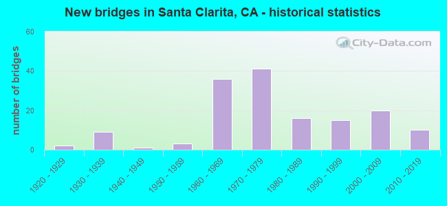
- New bridges - historical statistics
- 21920-1929
- 91930-1939
- 11940-1949
- 31950-1959
- 361960-1969
- 411970-1979
- 161980-1989
- 151990-1999
- 202000-2009
- 102010-2019

- Reconstructed bridges - Historical Statistics
- 11950-1959
- 01960-1969
- 01970-1979
- 21980-1989
- 151990-1999
- 22000-2009
- 62010-2019


- Bridge Condition - Deck
- 69.0%Good
- 9.2%Satisfactory
- 19.5%Fair
- 2.3%Poor

- Bridge Condition - Superstructure
- 2.2%Very good
- 86.5%Good
- 3.4%Satisfactory
- 7.9%Fair

- Bridge Condition - Substructure
- 89.9%Good
- 5.6%Satisfactory
- 4.5%Fair

- Bridge Condition - Channel
- 37.2%Excellent
- 37.2%Very good
- 8.1%Good
- 16.3%Satisfactory
- 1.2%Fair

- Bridge Condition - Culverts
- 10.0%Very good
- 73.3%Good
- 13.3%Satisfactory
- 3.3%Poor
Find on map >> Show street view
Structure Number: 53 0009L, Location: 07-LA-005-R56.26 (Lat: 34.451242, Lng: -118.614583), Route carried "on" structure: Interstate 5, Year Built: 1968, Year Reconstructed: 2010, Status: Open, Structure Length: 7.60m (24.93ft), Average Daily Traffic: 54,420 (year 2011), Truck Traffic: 17%, Average Future Daily Traffic: 73,584 (year 2038), Design Load: HS 20, Features Intersected: CASTAIC CREEK
Minimum Vertical Clearance: 30+ m (98+ ft), Kilometerpoint: 56.260, Lanes on structure: 5, Base Highway Network: Yes (, Subroute: 1), Owner: State Highway Agency, Approaching Roadway Width: 23.4m (76.8ft), Material/Design: Concrete continuous, Design/Construction: Box Beam or Girders - Multiple, Number Of Spans In Main Unit: 3, Length of Maximum Span: 32.2m (105.6ft), Curb-To-Curb Width: 23.4m (76.8ft), Out-to-Out Width: 24.3m (79.7ft)
Condition: Deck: Good, Superstructure: Good, Substructure: Good, Channel: Satisfactory, Operating Rating: 84.6 metric tons, Method Used To Determine Operating Rating: Load Factor (LF), Inventory Rating: 50.9 metric tons, Method Used To Determine Inventory Rating: Load Factor (LF), Structural Evaluation: Better than present minimum criteria, Deck Geometry: Equal to present minimum criteria, Waterway Adequacy: Equal to present desirable criteria, Approach Roadway Alignment: Equal to present desirable criteria, Designated Inspection Frequency: Every 24 months, Inspection Date: April 2021, Deck Structure Type: Concrete Cast-file-Place
Find on map >> Show street view
Structure Number: 53 0009R, Location: 07-LA-005-R56.26 (Lat: 34.451381, Lng: -118.614275), Route carried "on" structure: Interstate 5, Year Built: 1968, Year Reconstructed: 2010, Status: Open, Structure Length: 7.60m (24.93ft), Average Daily Traffic: 54,420 (year 2011), Truck Traffic: 17%, Average Future Daily Traffic: 73,584 (year 2038), Design Load: HS 20, Features Intersected: CASTAIC CREEK
Minimum Vertical Clearance: 30+ m (98+ ft), Kilometerpoint: 56.260, Lanes on structure: 5, Base Highway Network: Yes (, Subroute: 1), Owner: State Highway Agency, Approaching Roadway Width: 25.5m (83.7ft), Material/Design: Concrete continuous, Design/Construction: Box Beam or Girders - Multiple, Number Of Spans In Main Unit: 3, Length of Maximum Span: 32.2m (105.6ft), Curb-To-Curb Width: 25.5m (83.7ft), Out-to-Out Width: 26.4m (86.6ft)
Condition: Deck: Good, Superstructure: Good, Substructure: Good, Channel: Satisfactory, Operating Rating: 84.6 metric tons, Method Used To Determine Operating Rating: Load Factor (LF), Inventory Rating: 50.9 metric tons, Method Used To Determine Inventory Rating: Load Factor (LF), Structural Evaluation: Better than present minimum criteria, Deck Geometry: Better than present minimum criteria, Waterway Adequacy: Equal to present desirable criteria, Approach Roadway Alignment: Equal to present desirable criteria, Designated Inspection Frequency: Every 24 months, Inspection Date: April 2021, Deck Structure Type: Concrete Cast-file-Place
Find on map >> Show street view
Structure Number: 53 0363L, Location: 07-LA-014U-T27.37 (Lat: 34.372300, Lng: -118.499981), Route carried "on" structure: State highway 14, Year Built: 1969, Status: Open, Structure Length: 5.21m (17.09ft), Average Daily Traffic: 74,000 (year 2021), Truck Traffic: 4%, Average Future Daily Traffic: 117,382 (year 2039), Design Load: HS 20, Features Intersected: LOS ANGELES AQUEDUCT SHV
Minimum Vertical Clearance: 30+ m (98+ ft), Kilometerpoint: 27.370, Lanes on structure: 2, Base Highway Network: Yes, Owner: State Highway Agency, Approaching Roadway Width: 26.2m (86.0ft), Skew: 4 degrees, Material/Design: Concrete continuous, Design/Construction: Tee Beam, Number Of Spans In Main Unit: 3, Length of Maximum Span: 22.9m (75.1ft), Curb or Sidewalk Widths: Left: 1.5m (4.9ft), Right: 0.0m, Curb-To-Curb Width: 26.2m (86.0ft), Out-to-Out Width: 14.6m (47.9ft)
Condition: Deck: Fair, Superstructure: Good, Substructure: Good, Operating Rating: 38.6 metric tons, Method Used To Determine Operating Rating: Load and Resistance Factor Rating (LRFR) rating reported by rating factor(RF) method using HL-93 loadings, Inventory Rating: 29.8 metric tons, Method Used To Determine Inventory Rating: Load and Resistance Factor Rating (LRFR) rating reported by rating factor(RF) method using HL-93 loadings, Structural Evaluation: Better than present minimum criteria, Deck Geometry: Superior to present desirable criteria, Approach Roadway Alignment: Superior to present desirable criteria, Designated Inspection Frequency: Every 24 months, Inspection Date: January 2021, Deck Structure Type: Concrete Cast-file-Place
Find on map >> Show street view
Structure Number: 53 0363M, Location: 07-LA-014U-T27.37 (Lat: 34.372464, Lng: -118.499844), Route carried "on" structure: State highway 14, Year Built: 1938, Status: Open, Structure Length: 1.43m (4.69ft), Average Daily Traffic: 5,500 (year 2021), Truck Traffic: 2%, Average Future Daily Traffic: 6,907 (year 2043), Features Intersected: LOS ANGELES AQUEDUCT, Facility Carried by Structure: SIERRA HWY
Minimum Vertical Clearance: 30+ m (98+ ft), Kilometerpoint: 27.370, Lanes on structure: 2, Base Highway Network: Yes (, Subroute: 1), Owner: State Highway Agency, Approaching Roadway Width: 10.7m (35.1ft), Skew: 4 degrees, Material/Design: Concrete, Design/Construction: Culvert, Number Of Spans In Main Unit: 1, Length of Maximum Span: 12.8m (42.0ft), Curb-To-Curb Width: 10.7m (35.1ft), Out-to-Out Width: 10.7m (35.1ft)
Condition: Channel: Excellent, Culverts: Good, Operating Rating: 40.5 metric tons, Method Used To Determine Operating Rating: Field evaluation and documented engineering judgment, Inventory Rating: 24.3 metric tons, Method Used To Determine Inventory Rating: Field evaluation and documented engineering judgment, Structural Evaluation: Equal to present minimum criteria, Deck Geometry: Meets minimum limits, Waterway Adequacy: Equal to present desirable criteria, Approach Roadway Alignment: Equal to present desirable criteria, Designated Inspection Frequency: Every 24 months, Inspection Date: January 2021, Deck Structure Type: Concrete Cast-file-Place
Find on map >> Show street view
Structure Number: 53 0688, Location: 07-LA-005-R53.94-SCTA (Lat: 34.428272, Lng: -118.585711), Route carried "on" structure: Interstate 5, Year Built: 1964, Year Reconstructed: 2004, Status: Open, Structure Length: 4.85m (15.91ft), Average Daily Traffic: 134,090 (year 2011), Truck Traffic: 16%, Average Future Daily Traffic: 202,800 (year 2038), Design Load: HS 20, Features Intersected: ABANDONED RR
Minimum Vertical Clearance: 30+ m (98+ ft), Kilometerpoint: 53.940, Lanes on structure: 8, Base Highway Network: Yes (, Subroute: 1), Owner: State Highway Agency, Approaching Roadway Width: 46.2m (151.6ft), Skew: 32 degrees, Material/Design: Concrete, Design/Construction: Tee Beam, Number Of Spans In Main Unit: 3, Length of Maximum Span: 19.2m (63.0ft), Curb-To-Curb Width: 45.7m (149.9ft), Out-to-Out Width: 47.1m (154.5ft)
Condition: Deck: Fair, Superstructure: Good, Substructure: Good, Operating Rating: 39.2 metric tons, Method Used To Determine Operating Rating: Load and Resistance Factor Rating (LRFR) rating reported by rating factor(RF) method using HL-93 loadings, Inventory Rating: 30.1 metric tons, Method Used To Determine Inventory Rating: Load and Resistance Factor Rating (LRFR) rating reported by rating factor(RF) method using HL-93 loadings, Structural Evaluation: Better than present minimum criteria, Deck Geometry: Superior to present desirable criteria, Approach Roadway Alignment: Equal to present desirable criteria, Designated Inspection Frequency: Every 24 months, Inspection Date: April 2021, Deck Structure Type: Concrete Cast-file-Place
Find on map >> Show street view
Structure Number: 53 1539, Location: 07-LA-014-33.94 (Lat: 34.427547, Lng: -118.415378), Route carried "on" structure: State highway 14, Year Built: 1963, Year Reconstructed: 1998, Status: Open, Structure Length: 2.83m (9.28ft), Average Daily Traffic: 101,000 (year 2019), Truck Traffic: 6%, Average Future Daily Traffic: 205,286 (year 2039), Design Load: HS 20, Features Intersected: OAK SPRINGS RD
Minimum Vertical Clearance: 30+ m (98+ ft), Kilometerpoint: 33.940, Lanes on structure: 6, Lanes under structure: 2, Base Highway Network: Yes (, Subroute: 1), Owner: State Highway Agency, Approaching Roadway Width: 40.2m (131.9ft), Skew: 30 degrees, Material/Design: Concrete continuous, Design/Construction: Tee Beam, Number Of Spans In Main Unit: 3, Length of Maximum Span: 12.2m (40.0ft), Curb-To-Curb Width: 40.2m (131.9ft), Out-to-Out Width: 41.8m (137.1ft)
Condition: Deck: Good, Superstructure: Good, Substructure: Good, Operating Rating: 64.8 metric tons, Method Used To Determine Operating Rating: Load Factor (LF), Inventory Rating: 38.9 metric tons, Method Used To Determine Inventory Rating: Load Factor (LF), Structural Evaluation: Better than present minimum criteria, Deck Geometry: Superior to present desirable criteria, Underclear: Meets minimum limits, Approach Roadway Alignment: Equal to present desirable criteria, Designated Inspection Frequency: Every 48 months, Inspection Date: Febuary 2021, Deck Structure Type: Concrete Cast-file-Place
Find on map >> Show street view
Structure Number: 53 1547, Location: 07-LA-014-35.34 (Lat: 34.433328, Lng: -118.392364), Route carried "on" structure: State highway 14, Year Built: 1963, Year Reconstructed: 1999, Status: Open, Structure Length: 3.48m (11.42ft), Average Daily Traffic: 101,000 (year 2019), Truck Traffic: 6%, Average Future Daily Traffic: 205,286 (year 2039), Design Load: HS 20, Features Intersected: TICK CANYON WASH
Minimum Vertical Clearance: 30+ m (98+ ft), Kilometerpoint: 35.340, Lanes on structure: 6, Base Highway Network: Yes (, Subroute: 1), Owner: State Highway Agency, Approaching Roadway Width: 40.2m (131.9ft), Skew: 1 degrees, Material/Design: Concrete continuous, Design/Construction: Tee Beam, Number Of Spans In Main Unit: 3, Length of Maximum Span: 17.1m (56.1ft), Curb-To-Curb Width: 40.2m (131.9ft), Out-to-Out Width: 41.9m (137.5ft)
Condition: Deck: Good, Superstructure: Good, Substructure: Good, Channel: Satisfactory, Operating Rating: 33.7 metric tons, Method Used To Determine Operating Rating: Load and Resistance Factor Rating (LRFR) rating reported by rating factor(RF) method using HL-93 loadings, Inventory Rating: 25.3 metric tons, Method Used To Determine Inventory Rating: Load and Resistance Factor Rating (LRFR) rating reported by rating factor(RF) method using HL-93 loadings, Structural Evaluation: Equal to present minimum criteria, Deck Geometry: Superior to present desirable criteria, Waterway Adequacy: Equal to present desirable criteria, Approach Roadway Alignment: Equal to present desirable criteria, Designated Inspection Frequency: Every 24 months, Inspection Date: Febuary 2021, Deck Structure Type: Concrete Cast-file-Place
Find on map >> Show street view
Structure Number: 53 1549, Location: 07-LA-014-35.71 (Lat: 34.433461, Lng: -118.385844), Route carried "on" structure: State highway 14, Year Built: 1963, Year Reconstructed: 1998, Status: Open, Structure Length: 6.44m (21.13ft), Average Daily Traffic: 100,000 (year 2019), Truck Traffic: 14%, Average Future Daily Traffic: 194,155 (year 2039), Design Load: HS 20, Features Intersected: SOLEDAD CANYON RD, Facility Carried by Structure: SOLEDAD CANYON RD
Minimum Vertical Clearance: 30+ m (98+ ft), Kilometerpoint: 35.710, Lanes on structure: 6, Lanes under structure: 4, Base Highway Network: Yes (, Subroute: 1), Owner: State Highway Agency, Approaching Roadway Width: 40.2m (131.9ft), Skew: 4 degrees, Material/Design: Concrete continuous, Design/Construction: Tee Beam, Number Of Spans In Main Unit: 4, Length of Maximum Span: 16.8m (55.1ft), Curb-To-Curb Width: 40.2m (131.9ft), Out-to-Out Width: 41.9m (137.5ft)
Condition: Deck: Good, Superstructure: Good, Substructure: Good, Operating Rating: 70.0 metric tons, Method Used To Determine Operating Rating: Load Factor (LF), Inventory Rating: 42.1 metric tons, Method Used To Determine Inventory Rating: Load Factor (LF), Structural Evaluation: Better than present minimum criteria, Deck Geometry: Superior to present desirable criteria, Underclear: Meets minimum limits, Approach Roadway Alignment: Equal to present desirable criteria, Designated Inspection Frequency: Every 24 months, Inspection Date: Febuary 2021, Deck Structure Type: Concrete Cast-file-Place
Find on map >> Show street view
Structure Number: 53 1621, Location: 07-LA-014-32.53-SCTA (Lat: 34.418742, Lng: -118.437181), Route carried "on" structure: State highway 14, Year Built: 1963, Year Reconstructed: 1998, Status: Open, Structure Length: 2.83m (9.28ft), Average Daily Traffic: 113,000 (year 2019), Truck Traffic: 6%, Average Future Daily Traffic: 205,286 (year 2039), Design Load: HS 20, Features Intersected: LOST CANYON ROAD UC
Minimum Vertical Clearance: 30+ m (98+ ft), Kilometerpoint: 32.530, Lanes on structure: 8, Lanes under structure: 2, Base Highway Network: Yes (, Subroute: 1), Owner: State Highway Agency, Approaching Roadway Width: 41.5m (136.2ft), Skew: 30 degrees, Material/Design: Concrete continuous, Design/Construction: Tee Beam, Number Of Spans In Main Unit: 3, Length of Maximum Span: 12.2m (40.0ft), Curb-To-Curb Width: 41.5m (136.2ft), Out-to-Out Width: 43.1m (141.4ft)
Condition: Deck: Good, Superstructure: Good, Substructure: Good, Operating Rating: 71.0 metric tons, Method Used To Determine Operating Rating: Load Factor (LF), Inventory Rating: 42.8 metric tons, Method Used To Determine Inventory Rating: Load Factor (LF), Structural Evaluation: Better than present minimum criteria, Deck Geometry: Superior to present desirable criteria, Underclear: Meets minimum limits, Approach Roadway Alignment: Equal to present desirable criteria, Designated Inspection Frequency: Every 48 months, Inspection Date: Febuary 2021, Deck Structure Type: Concrete Cast-file-Place
Find on map >> Show street view
Structure Number: 53 1639, Location: 07-LA-126-R5.66 (Lat: 34.441569, Lng: -118.607789), Route carried "on" structure: State highway 126, Year Built: 1964, Year Reconstructed: 2005, Status: Open, Structure Length: 4.86m (15.94ft), Average Daily Traffic: 51,000 (year 2018), Truck Traffic: 17%, Average Future Daily Traffic: 89,728 (year 2042), Design Load: HS 20, Features Intersected: THE OLD ROAD
Minimum Vertical Clearance: 30+ m (98+ ft), Kilometerpoint: 5.660, Lanes on structure: 10, Lanes under structure: 4, Base Highway Network: Yes (Inventory Route: 1, Subroute: 1), Owner: State Highway Agency, Approaching Roadway Width: 51.0m (167.3ft), Skew: 10 degrees, Material/Design: Prestressed concrete continuous, Design/Construction: Stringer/Multi-beam, Number Of Spans In Main Unit: 3, Length of Maximum Span: 25.5m (83.7ft), Curb-To-Curb Width: 51.0m (167.3ft), Out-to-Out Width: 52.5m (172.2ft)
Condition: Deck: Good, Superstructure: Good, Substructure: Good, Operating Rating: 35.6 metric tons, Method Used To Determine Operating Rating: Load and Resistance Factor Rating (LRFR) rating reported by rating factor(RF) method using HL-93 loadings, Inventory Rating: 24.9 metric tons, Method Used To Determine Inventory Rating: Load and Resistance Factor Rating (LRFR) rating reported by rating factor(RF) method using HL-93 loadings, Structural Evaluation: Equal to present minimum criteria, Deck Geometry: Superior to present desirable criteria, Underclear: Meets minimum limits, Approach Roadway Alignment: Superior to present desirable criteria, Designated Inspection Frequency: Every 24 months, Inspection Date: October 2020, Deck Structure Type: Concrete Cast-file-Place
Find on map >> Show street view
Structure Number: 53 168, Location: 07-LA-101-28.29-LA (Lat: 34.153161, Lng: -118.651825), Route carried "on" structure: City street , Year Built: 1965, Year Reconstructed: 1996, Status: Open, Structure Length: 8.26m (27.10ft), Average Daily Traffic: 15,000 (year 2018), Truck Traffic: 1%, Average Future Daily Traffic: 22,001 (year 2040), Design Load: HS 20+Mod, Features Intersected: US 101, Facility Carried by Structure: PARKWAY CALABASAS
Minimum Vertical Clearance: 30+ m (98+ ft), Kilometerpoint: 0.000, Lanes on structure: 5, Lanes under structure: 8, Owner: State Highway Agency, Approaching Roadway Width: 23.1m (75.8ft), Material/Design: Prestressed concrete continuous, Design/Construction: Box Beam or Girders - Multiple, Number Of Spans In Main Unit: 3, Number Of Approach Spans: 2, Length of Maximum Span: 25.6m (84.0ft), Curb or Sidewalk Widths: Left: 0.0m, Right: 1.5m (4.9ft), Curb-To-Curb Width: 23.1m (75.8ft), Out-to-Out Width: 23.1m (75.8ft)
Condition: Deck: Good, Superstructure: Good, Substructure: Good, Operating Rating: 71.0 metric tons, Method Used To Determine Operating Rating: Load Factor (LF), Inventory Rating: 32.4 metric tons, Method Used To Determine Inventory Rating: Load Factor (LF), Structural Evaluation: Better than present minimum criteria, Deck Geometry: Better than present minimum criteria, Underclear: Meets minimum limits, Approach Roadway Alignment: Equal to present minimum criteria, Designated Inspection Frequency: Every 48 months, Inspection Date: May 2020, Deck Structure Type: Concrete Cast-file-Place, Wearing Surface/Protective System: Wearing Surface: Monolithic Concrete
Find on map >> Show street view
Structure Number: 53 1688, Location: 07-LA-005-R54.17-SCTA (Lat: 34.431106, Lng: -118.587789), Route carried "on" structure: Interstate 5, Year Built: 1964, Year Reconstructed: 2003, Status: Open, Structure Length: 4.88m (16.01ft), Average Daily Traffic: 134,080 (year 2011), Truck Traffic: 16%, Average Future Daily Traffic: 202,800 (year 2038), Design Load: HS 20, Features Intersected: RYE CANYON ROAD
Minimum Vertical Clearance: 30+ m (98+ ft), Kilometerpoint: 54.170, Lanes on structure: 8, Lanes under structure: 5, Base Highway Network: Yes (, Subroute: 1), Owner: State Highway Agency, Approaching Roadway Width: 45.7m (149.9ft), Skew: 30 degrees, Material/Design: Concrete continuous, Design/Construction: Tee Beam, Number Of Spans In Main Unit: 3, Length of Maximum Span: 25.6m (84.0ft), Curb-To-Curb Width: 45.7m (149.9ft), Out-to-Out Width: 47.1m (154.5ft)
Condition: Deck: Fair, Superstructure: Good, Substructure: Good, Operating Rating: 28.2 metric tons, Method Used To Determine Operating Rating: Load and Resistance Factor Rating (LRFR) rating reported by rating factor(RF) method using HL-93 loadings, Inventory Rating: 0.6 metric tons, Method Used To Determine Inventory Rating: Load and Resistance Factor Rating (LRFR) rating reported by rating factor(RF) method using HL-93 loadings, Structural Evaluation: High priority of corrective action, Deck Geometry: Superior to present desirable criteria, Underclear: Meets minimum limits, Approach Roadway Alignment: Equal to present desirable criteria, Designated Inspection Frequency: Every 24 months, Inspection Date: April 2021, Deck Structure Type: Concrete Cast-file-Place
Find on map >> Show street view
Structure Number: 53 1792L, Location: 07-LA-005-R49.03-SCTA (Lat: 34.362050, Lng: -118.555203), Route carried "on" structure: Interstate 5, Year Built: 1967, Year Reconstructed: 2015, Status: Open, Structure Length: 4.45m (14.60ft), Average Daily Traffic: 97,478 (year 2011), Truck Traffic: 13%, Average Future Daily Traffic: 119,654 (year 2041), Design Load: HS 20, Features Intersected: CALGROVE BLVD
Minimum Vertical Clearance: 30+ m (98+ ft), Kilometerpoint: 49.030, Lanes on structure: 5, Lanes under structure: 3, Base Highway Network: Yes (, Subroute: 1), Owner: State Highway Agency, Approaching Roadway Width: 25.7m (84.3ft), Skew: 3 degrees, Material/Design: Prestressed concrete, Design/Construction: Box Beam or Girders - Multiple, Number Of Spans In Main Unit: 1, Length of Maximum Span: 44.3m (145.3ft), Curb-To-Curb Width: 25.7m (84.3ft), Out-to-Out Width: 26.5m (86.9ft)
Condition: Deck: Good, Superstructure: Good, Substructure: Good, Operating Rating: 98.5 metric tons, Method Used To Determine Operating Rating: Load Factor (LF), Inventory Rating: 32.4 metric tons, Method Used To Determine Inventory Rating: Load Factor (LF), Structural Evaluation: Better than present minimum criteria, Deck Geometry: Better than present minimum criteria, Underclear: Somewhat better than minimum adequacy, Approach Roadway Alignment: Equal to present desirable criteria, Designated Inspection Frequency: Every 24 months, Inspection Date: March 2021, Deck Structure Type: Concrete Cast-file-Place
Find on map >> Show street view
Structure Number: 53 1792R, Location: 07-LA-005-R49.03-SCTA (Lat: 34.362333, Lng: -118.554881), Route carried "on" structure: Interstate 5, Year Built: 1967, Year Reconstructed: 2015, Status: Open, Structure Length: 4.45m (14.60ft), Average Daily Traffic: 97,478 (year 2011), Truck Traffic: 9%, Average Future Daily Traffic: 119,654 (year 2041), Design Load: HS 20, Features Intersected: CALGROVE BLVD
Minimum Vertical Clearance: 30+ m (98+ ft), Kilometerpoint: 49.030, Lanes on structure: 4, Lanes under structure: 3, Base Highway Network: Yes (, Subroute: 1), Owner: State Highway Agency, Approaching Roadway Width: 25.7m (84.3ft), Skew: 3 degrees, Material/Design: Prestressed concrete, Design/Construction: Box Beam or Girders - Multiple, Number Of Spans In Main Unit: 1, Length of Maximum Span: 44.3m (145.3ft), Curb-To-Curb Width: 25.7m (84.3ft), Out-to-Out Width: 26.5m (86.9ft)
Condition: Deck: Good, Superstructure: Good, Substructure: Good, Operating Rating: 98.5 metric tons, Method Used To Determine Operating Rating: Load Factor (LF), Inventory Rating: 32.4 metric tons, Method Used To Determine Inventory Rating: Load Factor (LF), Structural Evaluation: Better than present minimum criteria, Deck Geometry: Superior to present desirable criteria, Underclear: Somewhat better than minimum adequacy, Approach Roadway Alignment: Equal to present desirable criteria, Designated Inspection Frequency: Every 24 months, Inspection Date: March 2021, Deck Structure Type: Concrete Cast-file-Place
Find on map >> Show street view
Structure Number: 53 1796, Location: 07-LA-005-R46.58 (Lat: 34.340706, Lng: -118.522856), Route carried "on" structure: County highway , Year Built: 1967, Status: Open, Structure Length: 6.71m (22.01ft), Average Daily Traffic: 812 (year 2011), Truck Traffic: 1%, Average Future Daily Traffic: 1,069 (year 2041), Design Load: HS 20, Features Intersected: INTERSTATE 5, Facility Carried by Structure: WELDON CANYON OC
Minimum Vertical Clearance: 30+ m (98+ ft), Kilometerpoint: 0.000, Lanes on structure: 2, Lanes under structure: 10, Owner: State Highway Agency, Approaching Roadway Width: 12.8m (42.0ft), Material/Design: Concrete continuous, Design/Construction: Box Beam or Girders - Multiple, Number Of Spans In Main Unit: 2, Length of Maximum Span: 33.4m (109.6ft), Curb or Sidewalk Widths: Left: 0.0m, Right: 1.5m (4.9ft), Curb-To-Curb Width: 9.8m (32.2ft), Out-to-Out Width: 12.1m (39.7ft)
Condition: Deck: Good, Superstructure: Good, Substructure: Good, Operating Rating: 61.9 metric tons, Method Used To Determine Operating Rating: Load and Resistance Factor Rating (LRFR) rating reported by rating factor(RF) method using HL-93 loadings, Inventory Rating: 48.0 metric tons, Method Used To Determine Inventory Rating: Load and Resistance Factor Rating (LRFR) rating reported by rating factor(RF) method using HL-93 loadings, Structural Evaluation: Better than present minimum criteria, Deck Geometry: Equal to present minimum criteria, Underclear: High priority of corrective action, Approach Roadway Alignment: Equal to present minimum criteria, Designated Inspection Frequency: Every 24 months, Inspection Date: Febuary 2021, Deck Structure Type: Concrete Cast-file-Place
Find on map >> Show street view
Structure Number: 53 1807, Location: 07-LA-005-R56.12 (Lat: 34.449344, Lng: -118.613803), Route carried "on" structure: County highway , Year Built: 1968, Status: Open, Structure Length: 8.46m (27.76ft), Average Daily Traffic: 1,647 (year 2011), Truck Traffic: 1%, Average Future Daily Traffic: 2,150 (year 2038), Design Load: HS 20, Features Intersected: ROUTE 5, Facility Carried by Structure: HONOR RANCHO RD
Minimum Vertical Clearance: 30+ m (98+ ft), Kilometerpoint: 0.000, Lanes on structure: 2, Lanes under structure: 8, Owner: State Highway Agency, Approaching Roadway Width: 8.5m (27.9ft), Material/Design: Steel, Design/Construction: Stringer/Multi-beam, Number Of Spans In Main Unit: 3, Length of Maximum Span: 32.3m (106.0ft), Curb or Sidewalk Widths: Left: 0.6m (2.0ft), Right: 0.6m (2.0ft), Curb-To-Curb Width: 8.5m (27.9ft), Out-to-Out Width: 10.4m (34.1ft)
Condition: Deck: Good, Superstructure: Good, Substructure: Good, Operating Rating: 74.8 metric tons, Method Used To Determine Operating Rating: Load Factor (LF), Inventory Rating: 44.7 metric tons, Method Used To Determine Inventory Rating: Load Factor (LF), Structural Evaluation: Better than present minimum criteria, Deck Geometry: Somewhat better than minimum adequacy, Underclear: Meets minimum limits, Approach Roadway Alignment: Equal to present minimum criteria, Designated Inspection Frequency: Every 24 months, Other Special Inspection Frequency: Every 48 months, Inspection Date: April 2021, Other Special Inspection Date: April 2020, Deck Structure Type: Concrete Cast-file-Place
Find on map >> Show street view
Structure Number: 53 1936F, Location: 07-LA-014-R25.13 (Lat: 34.338714, Lng: -118.507572), Route carried "on" structure: Ramp State highway 14, Year Built: 1971, Status: Open, Structure Length: 5.61m (18.41ft), Average Daily Traffic: 9,700 (year 2021), Truck Traffic: 14%, Average Future Daily Traffic: 11,858 (year 2041), Design Load: HS 20, Features Intersected: SIERRA HWY
Minimum Vertical Clearance: 30+ m (98+ ft), Kilometerpoint: 25.130, Lanes on structure: 2, Lanes under structure: 4, Owner: State Highway Agency, Approaching Roadway Width: 11.9m (39.0ft), Material/Design: Concrete continuous, Design/Construction: Box Beam or Girders - Multiple, Number Of Spans In Main Unit: 3, Length of Maximum Span: 31.9m (104.7ft), Curb-To-Curb Width: 11.9m (39.0ft), Out-to-Out Width: 12.5m (41.0ft)
Condition: Deck: Satisfactory, Superstructure: Good, Substructure: Good, Operating Rating: 43.1 metric tons, Method Used To Determine Operating Rating: Load and Resistance Factor Rating (LRFR) rating reported by rating factor(RF) method using HL-93 loadings, Inventory Rating: 33.4 metric tons, Method Used To Determine Inventory Rating: Load and Resistance Factor Rating (LRFR) rating reported by rating factor(RF) method using HL-93 loadings, Structural Evaluation: Better than present minimum criteria, Deck Geometry: Superior to present desirable criteria, Underclear: Better than present minimum criteria, Approach Roadway Alignment: Equal to present desirable criteria, Designated Inspection Frequency: Every 24 months, Inspection Date: January 2021, Deck Structure Type: Concrete Cast-file-Place
Find on map >> Show street view
Structure Number: 53 2027, Location: 07-LA-014-R31.88 (Lat: 34.413419, Lng: -118.444847), Route carried "on" structure: State highway 14, Year Built: 1972, Year Reconstructed: 1998, Status: Open, Structure Length: 28.33m (92.95ft), Average Daily Traffic: 113,000 (year 2019), Truck Traffic: 6%, Average Future Daily Traffic: 205,286 (year 2039), Design Load: HS 20, Features Intersected: SANTA CLARA RIVER
Minimum Vertical Clearance: 30+ m (98+ ft), Kilometerpoint: 31.880, Lanes on structure: 8, Base Highway Network: Yes (, Subroute: 1), Owner: State Highway Agency, Approaching Roadway Width: 45.7m (149.9ft), Skew: 9 degrees, Material/Design: Concrete continuous, Design/Construction: Box Beam or Girders - Multiple, Number Of Spans In Main Unit: 10, Length of Maximum Span: 29.3m (96.1ft), Curb-To-Curb Width: 45.7m (149.9ft), Out-to-Out Width: 47.2m (154.9ft)
Condition: Deck: Good, Superstructure: Good, Substructure: Good, Channel: Very good, Operating Rating: 75.2 metric tons, Method Used To Determine Operating Rating: Load Factor (LF), Inventory Rating: 45.4 metric tons, Method Used To Determine Inventory Rating: Load Factor (LF), Structural Evaluation: Better than present minimum criteria, Deck Geometry: Superior to present desirable criteria, Waterway Adequacy: Equal to present minimum criteria, Approach Roadway Alignment: Equal to present desirable criteria, Designated Inspection Frequency: Every 24 months, Inspection Date: Febuary 2021, Deck Structure Type: Concrete Cast-file-Place
Find on map >> Show street view
Structure Number: 53 2029, Location: 07-LA-014-R31.62-SCTA (Lat: 34.409831, Lng: -118.446147), Route carried "on" structure: State highway 14, Year Built: 1972, Year Reconstructed: 1998, Status: Open, Structure Length: 6.10m (20.01ft), Average Daily Traffic: 113,000 (year 2019), Truck Traffic: 6%, Average Future Daily Traffic: 205,286 (year 2039), Design Load: HS 20, Features Intersected: METROLINK & UP RR
Minimum Vertical Clearance: 30+ m (98+ ft), Kilometerpoint: 31.620, Lanes on structure: 8, Base Highway Network: Yes (, Subroute: 1), Owner: State Highway Agency, Approaching Roadway Width: 53.0m (173.9ft), Skew: 39 degrees, Material/Design: Concrete continuous, Design/Construction: Box Beam or Girders - Multiple, Number Of Spans In Main Unit: 3, Length of Maximum Span: 28.3m (92.8ft), Curb-To-Curb Width: 53.0m (173.9ft), Out-to-Out Width: 54.2m (177.8ft)
Condition: Deck: Good, Superstructure: Good, Substructure: Good, Operating Rating: 44.7 metric tons, Method Used To Determine Operating Rating: Load and Resistance Factor Rating (LRFR) rating reported by rating factor(RF) method using HL-93 loadings, Inventory Rating: 33.7 metric tons, Method Used To Determine Inventory Rating: Load and Resistance Factor Rating (LRFR) rating reported by rating factor(RF) method using HL-93 loadings, Structural Evaluation: Better than present minimum criteria, Deck Geometry: Superior to present desirable criteria, Underclear: Superior to present desirable criteria, Approach Roadway Alignment: Equal to present desirable criteria, Designated Inspection Frequency: Every 48 months, Inspection Date: Febuary 2021, Deck Structure Type: Concrete Cast-file-Place
Find on map >> Show street view
Structure Number: 53 2066, Location: 07-LA-014-R29.28 (Lat: 34.392606, Lng: -118.473108), Route carried "on" structure: County highway Q067, Year Built: 1972, Year Reconstructed: 2016, Status: Open, Structure Length: 7.96m (26.12ft), Average Daily Traffic: 2,300 (year 2021), Truck Traffic: 14%, Average Future Daily Traffic: 2,568 (year 2043), Design Load: HS 20, Features Intersected: STATE ROUTE 14, Facility Carried by Structure: GOLDEN VALLEY ROAD
Minimum Vertical Clearance: 30+ m (98+ ft), Kilometerpoint: 0.000, Lanes on structure: 2, Lanes under structure: 8, Owner: State Highway Agency, Approaching Roadway Width: 25.0m (82.0ft), Skew: 1 degrees, Material/Design: Prestressed concrete continuous, Design/Construction: Box Beam or Girders - Multiple, Number Of Spans In Main Unit: 2, Length of Maximum Span: 41.4m (135.8ft), Curb or Sidewalk Widths: Left: 1.8m (5.9ft), Right: 0.0m, Curb-To-Curb Width: 25.0m (82.0ft), Out-to-Out Width: 32.9m (107.9ft)
Condition: Deck: Good, Superstructure: Good, Substructure: Good, Operating Rating: 57.3 metric tons, Method Used To Determine Operating Rating: Load and Resistance Factor Rating (LRFR) rating reported by rating factor(RF) method using HL-93 loadings, Inventory Rating: 39.5 metric tons, Method Used To Determine Inventory Rating: Load and Resistance Factor Rating (LRFR) rating reported by rating factor(RF) method using HL-93 loadings, Structural Evaluation: Better than present minimum criteria, Deck Geometry: Superior to present desirable criteria, Underclear: Meets minimum limits, Approach Roadway Alignment: Equal to present desirable criteria, Designated Inspection Frequency: Every 24 months, Inspection Date: January 2021, Deck Structure Type: Concrete Cast-file-Place
Find on map >> Show street view
Structure Number: 53 2070S, Location: 07-LA-014-R27.04 (Lat: 34.364814, Lng: -118.503217), Route carried "on" structure: Ramp State highway 14, Year Built: 1971, Status: Open, Structure Length: 4.63m (15.19ft), Average Daily Traffic: 1,500 (year 2021), Truck Traffic: 14%, Average Future Daily Traffic: 1,834 (year 2041), Design Load: HS 20, Features Intersected: NEWHALL AVENUE
Minimum Vertical Clearance: 30+ m (98+ ft), Kilometerpoint: 27.040, Lanes on structure: 2, Lanes under structure: 5, Owner: State Highway Agency, Approaching Roadway Width: 11.0m (36.1ft), Material/Design: Prestressed concrete, Design/Construction: Box Beam or Girders - Multiple, Number Of Spans In Main Unit: 1, Length of Maximum Span: 45.8m (150.3ft), Curb-To-Curb Width: 11.0m (36.1ft), Out-to-Out Width: 11.6m (38.1ft)
Condition: Deck: Good, Superstructure: Good, Substructure: Good, Operating Rating: 51.2 metric tons, Method Used To Determine Operating Rating: Load and Resistance Factor Rating (LRFR) rating reported by rating factor(RF) method using HL-93 loadings, Inventory Rating: 32.4 metric tons, Method Used To Determine Inventory Rating: Load and Resistance Factor Rating (LRFR) rating reported by rating factor(RF) method using HL-93 loadings, Structural Evaluation: Better than present minimum criteria, Deck Geometry: Better than present minimum criteria, Underclear: Somewhat better than minimum adequacy, Approach Roadway Alignment: Equal to present desirable criteria, Designated Inspection Frequency: Every 24 months, Inspection Date: January 2021, Deck Structure Type: Concrete Cast-file-Place
Find on map >> Show street view
Structure Number: 53 2076, Location: 07-LA-014-R28.08 (Lat: 34.377347, Lng: -118.493533), Route carried "on" structure: State highway 14, Year Built: 1972, Year Reconstructed: 1998, Status: Open, Structure Length: 4.66m (15.29ft), Average Daily Traffic: 148,000 (year 2021), Truck Traffic: 4%, Average Future Daily Traffic: 234,766 (year 2041), Design Load: HS 20, Features Intersected: PLACERITA CANYON RD
Minimum Vertical Clearance: 30+ m (98+ ft), Kilometerpoint: 28.080, Lanes on structure: 10, Lanes under structure: 4, Base Highway Network: Yes (, Subroute: 1), Owner: State Highway Agency, Approaching Roadway Width: 55.1m (180.8ft), Skew: 30 degrees, Material/Design: Prestressed concrete, Design/Construction: Box Beam or Girders - Multiple, Number Of Spans In Main Unit: 1, Length of Maximum Span: 45.7m (149.9ft), Curb-To-Curb Width: 55.1m (180.8ft), Out-to-Out Width: 56.0m (183.7ft)
Condition: Deck: Good, Superstructure: Good, Substructure: Good, Operating Rating: 46.3 metric tons, Method Used To Determine Operating Rating: Load and Resistance Factor Rating (LRFR) rating reported by rating factor(RF) method using HL-93 loadings, Inventory Rating: 26.6 metric tons, Method Used To Determine Inventory Rating: Load and Resistance Factor Rating (LRFR) rating reported by rating factor(RF) method using HL-93 loadings, Structural Evaluation: Equal to present minimum criteria, Deck Geometry: Superior to present desirable criteria, Underclear: Somewhat better than minimum adequacy, Approach Roadway Alignment: Equal to present desirable criteria, Designated Inspection Frequency: Every 24 months, Inspection Date: January 2021, Deck Structure Type: Concrete Cast-file-Place
Find on map >> Show street view
Structure Number: 53 2094, Location: 07-LA-014-R28.20 (Lat: 34.378275, Lng: -118.492519), Route carried "on" structure: State highway 14, Year Built: 1969, Status: Open, Structure Length: 0.64m (2.10ft), Average Daily Traffic: 148,000 (year 2021), Truck Traffic: 4%, Average Future Daily Traffic: 234,766 (year 2041), Features Intersected: PLACERITA CREEK
Minimum Vertical Clearance: 30+ m (98+ ft), Kilometerpoint: 28.200, Lanes on structure: 8, Base Highway Network: Yes (, Subroute: 1), Owner: State Highway Agency, Approaching Roadway Width: 49.7m (163.1ft), Material/Design: Steel, Design/Construction: Culvert, Number Of Spans In Main Unit: 1, Length of Maximum Span: 6.1m (20.0ft), Curb-To-Curb Width: 49.7m (163.1ft), Out-to-Out Width: 219.5m (720.1ft)
Condition: Channel: Very good, Culverts: Good, Structural Evaluation: Better than present minimum criteria, Deck Geometry: Superior to present desirable criteria, Waterway Adequacy: Equal to present desirable criteria, Approach Roadway Alignment: Equal to present desirable criteria, Designated Inspection Frequency: Every 24 months, Inspection Date: January 2021
Find on map >> Show street view
Structure Number: 53 2096, Location: 07-LA-014-R25.97-SCTA (Lat: 34.350361, Lng: -118.503942), Route carried "on" structure: State highway 14, Year Built: 1971, Year Reconstructed: 2001, Status: Open, Structure Length: 4.21m (13.81ft), Average Daily Traffic: 159,000 (year 2021), Truck Traffic: 8%, Average Future Daily Traffic: 241,131 (year 2041), Design Load: HS 20, Features Intersected: LOS PINETOS ROAD
Minimum Vertical Clearance: 30+ m (98+ ft), Kilometerpoint: 25.970, Lanes on structure: 11, Lanes under structure: 2, Base Highway Network: Yes (, Subroute: 1), Owner: State Highway Agency, Approaching Roadway Width: 53.0m (173.9ft), Skew: 31 degrees, Material/Design: Prestressed concrete, Design/Construction: Box Beam or Girders - Multiple, Number Of Spans In Main Unit: 1, Length of Maximum Span: 41.5m (136.2ft), Curb-To-Curb Width: 53.0m (173.9ft), Out-to-Out Width: 54.3m (178.1ft)
Condition: Deck: Good, Superstructure: Good, Substructure: Good, Operating Rating: 71.6 metric tons, Method Used To Determine Operating Rating: Load Factor (LF), Inventory Rating: 27.5 metric tons, Method Used To Determine Inventory Rating: Load Factor (LF), Structural Evaluation: Equal to present minimum criteria, Deck Geometry: Superior to present desirable criteria, Underclear: Superior to present desirable criteria, Approach Roadway Alignment: Equal to present desirable criteria, Designated Inspection Frequency: Every 24 months, Inspection Date: January 2021, Deck Structure Type: Concrete Cast-file-Place
Find on map >> Show street view
Structure Number: 53 2139M, Location: 07-LA-005-R49.20 (Lat: 34.362967, Lng: -118.555881), Route carried "on" structure: Interstate 5, Year Built: 1967, Status: Open, Structure Length: 2.32m (7.61ft), Average Daily Traffic: 206,377 (year 2011), Truck Traffic: 13%, Average Future Daily Traffic: 407,038 (year 2041), Design Load: HS 20, Features Intersected: WILEY CANYON CHANNEL
Minimum Vertical Clearance: 30+ m (98+ ft), Kilometerpoint: 49.200, Lanes on structure: 10, Base Highway Network: Yes (, Subroute: 1), Owner: State Highway Agency, Approaching Roadway Width: 52.4m (171.9ft), Skew: 6 degrees, Material/Design: Concrete continuous, Design/Construction: Culvert, Number Of Spans In Main Unit: 3, Length of Maximum Span: 7.9m (25.9ft), Curb-To-Curb Width: 52.4m (171.9ft), Out-to-Out Width: 100.0m (328.1ft)
Condition: Channel: Very good, Culverts: Good, Operating Rating: 54.1 metric tons, Method Used To Determine Operating Rating: Field evaluation and documented engineering judgment, Inventory Rating: 32.4 metric tons, Method Used To Determine Inventory Rating: Field evaluation and documented engineering judgment, Structural Evaluation: Better than present minimum criteria, Deck Geometry: Superior to present desirable criteria, Waterway Adequacy: Equal to present desirable criteria, Approach Roadway Alignment: Equal to present desirable criteria, Designated Inspection Frequency: Every 24 months, Inspection Date: March 2021
Find on map >> Show street view
Structure Number: 53 2146, Location: 07-LA-014-R27.55-SCTA (Lat: 34.371517, Lng: -118.499681), Route carried "on" structure: State highway 14, Year Built: 1972, Year Reconstructed: 1998, Status: Open, Structure Length: 10.94m (35.89ft), Average Daily Traffic: 148,000 (year 2021), Truck Traffic: 4%, Average Future Daily Traffic: 234,766 (year 2041), Design Load: HS 20, Features Intersected: LA AQUEDUCT
Minimum Vertical Clearance: 30+ m (98+ ft), Kilometerpoint: 27.550, Lanes on structure: 8, Lanes under structure: 1, Base Highway Network: Yes (, Subroute: 1), Owner: State Highway Agency, Approaching Roadway Width: 45.7m (149.9ft), Skew: 39 degrees, Material/Design: Concrete continuous, Design/Construction: Box Beam or Girders - Single/Spread, Number Of Spans In Main Unit: 5, Length of Maximum Span: 25.3m (83.0ft), Curb-To-Curb Width: 45.7m (149.9ft), Out-to-Out Width: 46.9m (153.9ft)
Condition: Deck: Fair, Superstructure: Good, Substructure: Good, Channel: Excellent, Operating Rating: 54.1 metric tons, Method Used To Determine Operating Rating: Assigned rating based on Load Factor Design (LFD) reported in metric tons, Inventory Rating: 32.4 metric tons, Method Used To Determine Inventory Rating: Assigned rating based on Load Factor Design (LFD) reported in metric tons, Structural Evaluation: Better than present minimum criteria, Deck Geometry: Superior to present desirable criteria, Underclear: Equal to present minimum criteria, Waterway Adequacy: Equal to present desirable criteria, Approach Roadway Alignment: Equal to present desirable criteria, Designated Inspection Frequency: Every 24 months, Inspection Date: January 2021, Deck Structure Type: Concrete Cast-file-Place
Find on map >> Show street view
Structure Number: 53 2166, Location: 07-LA-014-R30.89 (Lat: 34.402308, Lng: -118.454964), Route carried "on" structure: State highway 14, Year Built: 1972, Year Reconstructed: 1998, Status: Open, Structure Length: 4.84m (15.88ft), Average Daily Traffic: 143,000 (year 2021), Truck Traffic: 9%, Average Future Daily Traffic: 225,232 (year 2041), Design Load: HS 20, Features Intersected: VIA PRINCESSA
Minimum Vertical Clearance: 30+ m (98+ ft), Kilometerpoint: 30.890, Lanes on structure: 8, Lanes under structure: 5, Base Highway Network: Yes (, Subroute: 1), Owner: State Highway Agency, Approaching Roadway Width: 45.7m (149.9ft), Skew: 39 degrees, Material/Design: Prestressed concrete, Design/Construction: Box Beam or Girders - Multiple, Number Of Spans In Main Unit: 1, Length of Maximum Span: 48.0m (157.5ft), Curb-To-Curb Width: 45.7m (149.9ft), Out-to-Out Width: 46.9m (153.9ft)
Condition: Deck: Good, Superstructure: Good, Substructure: Fair, Operating Rating: 62.2 metric tons, Method Used To Determine Operating Rating: Load and Resistance Factor Rating (LRFR) rating reported by rating factor(RF) method using HL-93 loadings, Inventory Rating: 32.4 metric tons, Method Used To Determine Inventory Rating: Load and Resistance Factor Rating (LRFR) rating reported by rating factor(RF) method using HL-93 loadings, Structural Evaluation: Somewhat better than minimum adequacy, Deck Geometry: Superior to present desirable criteria, Underclear: Meets minimum limits, Approach Roadway Alignment: Equal to present desirable criteria, Designated Inspection Frequency: Every 24 months, Inspection Date: January 2021, Deck Structure Type: Concrete Cast-file-Place
Find on map >> Show street view
Structure Number: 53 2167, Location: 07-LA-014-R31.40-SCTA (Lat: 34.406664, Lng: -118.447794), Route carried "on" structure: State highway 14, Year Built: 1972, Year Reconstructed: 1996, Status: Open, Structure Length: 4.19m (13.75ft), Average Daily Traffic: 113,000 (year 2021), Truck Traffic: 6%, Average Future Daily Traffic: 205,286 (year 2041), Design Load: HS 20, Features Intersected: CANYON PARK BLVD
Minimum Vertical Clearance: 30+ m (98+ ft), Kilometerpoint: 31.400, Lanes on structure: 9, Lanes under structure: 4, Base Highway Network: Yes (, Subroute: 1), Owner: State Highway Agency, Approaching Roadway Width: 56.3m (184.7ft), Skew: 39 degrees, Material/Design: Prestressed concrete, Design/Construction: Box Beam or Girders - Multiple, Number Of Spans In Main Unit: 1, Length of Maximum Span: 41.3m (135.5ft), Curb-To-Curb Width: 56.3m (184.7ft), Out-to-Out Width: 57.6m (189.0ft)
Condition: Deck: Fair, Superstructure: Good, Substructure: Good, Operating Rating: 45.7 metric tons, Method Used To Determine Operating Rating: Load and Resistance Factor Rating (LRFR) rating reported by rating factor(RF) method using HL-93 loadings, Inventory Rating: 30.1 metric tons, Method Used To Determine Inventory Rating: Load and Resistance Factor Rating (LRFR) rating reported by rating factor(RF) method using HL-93 loadings, Structural Evaluation: Better than present minimum criteria, Deck Geometry: Superior to present desirable criteria, Underclear: Somewhat better than minimum adequacy, Approach Roadway Alignment: Equal to present desirable criteria, Designated Inspection Frequency: Every 24 months, Inspection Date: January 2021, Deck Structure Type: Concrete Cast-file-Place
Find on map >> Show street view
Structure Number: 53 2201K, Location: 07-LA-014-R30.91 (Lat: 34.403050, Lng: -118.457267), Route carried "on" structure: Bypass US 14, Year Built: 1972, Status: Open, Structure Length: 5.61m (18.41ft), Average Daily Traffic: 6,500 (year 2021), Truck Traffic: 2%, Average Future Daily Traffic: 8,241 (year 2041), Design Load: HS 20, Features Intersected: VIA PRINCESSA
Minimum Vertical Clearance: 30+ m (98+ ft), Kilometerpoint: 30.910, Lanes on structure: 2, Lanes under structure: 5, Base Highway Network: Yes (, Subroute: 1), Owner: State Highway Agency, Approaching Roadway Width: 16.2m (53.1ft), Skew: 9 degrees, Material/Design: Concrete continuous, Design/Construction: Box Beam or Girders - Multiple, Number Of Spans In Main Unit: 3, Length of Maximum Span: 33.5m (109.9ft), Curb-To-Curb Width: 14.6m (47.9ft), Out-to-Out Width: 15.2m (49.9ft)
Condition: Deck: Poor, Superstructure: Good, Substructure: Good, Operating Rating: 50.9 metric tons, Method Used To Determine Operating Rating: Load and Resistance Factor Rating (LRFR) rating reported by rating factor(RF) method using HL-93 loadings, Inventory Rating: 39.2 metric tons, Method Used To Determine Inventory Rating: Load and Resistance Factor Rating (LRFR) rating reported by rating factor(RF) method using HL-93 loadings, Structural Evaluation: Better than present minimum criteria, Deck Geometry: Superior to present desirable criteria, Underclear: Meets minimum limits, Approach Roadway Alignment: Equal to present desirable criteria, Designated Inspection Frequency: Every 24 months, Inspection Date: January 2021, Deck Structure Type: Concrete Cast-file-Place
Find on map >> Show street view
Structure Number: 53 2608, Location: 07-LA-014-R27.10 (Lat: 34.365967, Lng: -118.502803), Route carried "on" structure: State highway 14, Year Built: 1971, Status: Open, Structure Length: 0.67m (2.20ft), Average Daily Traffic: 148,000 (year 2009), Truck Traffic: 4%, Average Future Daily Traffic: 233,209 (year 2037), Design Load: HS 20, Features Intersected: WHITNEY CREEK
Minimum Vertical Clearance: 30+ m (98+ ft), Kilometerpoint: 27.100, Lanes on structure: 9, Base Highway Network: Yes (, Subroute: 1), Owner: State Highway Agency, Approaching Roadway Width: 41.5m (136.2ft), Skew: 1 degrees, Material/Design: Concrete continuous, Design/Construction: Culvert, Number Of Spans In Main Unit: 2, Length of Maximum Span: 3.0m (9.8ft), Curb-To-Curb Width: 41.5m (136.2ft), Out-to-Out Width: 279.0m (915.4ft)
Condition: Channel: Very good, Culverts: Good, Operating Rating: 54.1 metric tons, Method Used To Determine Operating Rating: Field evaluation and documented engineering judgment, Inventory Rating: 32.4 metric tons, Method Used To Determine Inventory Rating: Field evaluation and documented engineering judgment, Structural Evaluation: Better than present minimum criteria, Deck Geometry: Superior to present desirable criteria, Waterway Adequacy: Equal to present minimum criteria, Approach Roadway Alignment: Equal to present desirable criteria, Designated Inspection Frequency: Every 48 months, Inspection Date: January 2019
Find on map >> Show street view
Structure Number: 53 2790R, Location: 07-LA-005-R47.83 (Lat: 34.349883, Lng: -118.540756), Route carried "on" structure: Interstate 5, Year Built: 1994, Year Reconstructed: 2015, Status: Open, Structure Length: 23.32m (76.51ft), Average Daily Traffic: 96,663 (year 2011), Truck Traffic: 9%, Average Future Daily Traffic: 98,869 (year 2038), Design Load: HS 20, Features Intersected: THE OLD ROAD
Minimum Vertical Clearance: 30+ m (98+ ft), Kilometerpoint: 47.830, Lanes on structure: 5, Lanes under structure: 4, Base Highway Network: Yes (, Subroute: 1), Owner: State Highway Agency, Approaching Roadway Width: 25.7m (84.3ft), Skew: 4 degrees, Material/Design: Prestressed concrete continuous, Design/Construction: Box Beam or Girders - Multiple, Number Of Spans In Main Unit: 3, Length of Maximum Span: 88.4m (290.0ft), Curb-To-Curb Width: 25.7m (84.3ft), Out-to-Out Width: 26.7m (87.6ft)
Condition: Deck: Good, Superstructure: Good, Substructure: Good, Operating Rating: 54.1 metric tons, Method Used To Determine Operating Rating: Assigned rating based on Load Factor Design (LFD) reported in metric tons, Inventory Rating: 32.4 metric tons, Method Used To Determine Inventory Rating: Assigned rating based on Load Factor Design (LFD) reported in metric tons, Structural Evaluation: Better than present minimum criteria, Deck Geometry: Better than present minimum criteria, Underclear: Meets minimum limits, Approach Roadway Alignment: Superior to present desirable criteria, Designated Inspection Frequency: Every 24 months, Inspection Date: Febuary 2021, Deck Structure Type: Concrete Cast-file-Place, Wearing Surface/Protective System: Wearing Surface: Integral Concrete
Find on map >> Show street view
Structure Number: 53 2809L, Location: 07-LA-005-R50.80 (Lat: 34.385864, Lng: -118.568894), Route carried "on" structure: Interstate 5, Year Built: 1994, Status: Open, Structure Length: 4.63m (15.19ft), Average Daily Traffic: 96,576 (year 2011), Truck Traffic: 10%, Average Future Daily Traffic: 105,268 (year 2041), Design Load: HS 20+Mod, Features Intersected: BUTTE CANYON
Minimum Vertical Clearance: 30+ m (98+ ft), Kilometerpoint: 50.800, Lanes on structure: 4, Base Highway Network: Yes (, Subroute: 1), Owner: State Highway Agency, Approaching Roadway Width: 20.7m (67.9ft), Skew: 3 degrees, Material/Design: Prestressed concrete, Design/Construction: Box Beam or Girders - Multiple, Number Of Spans In Main Unit: 1, Length of Maximum Span: 45.8m (150.3ft), Curb-To-Curb Width: 20.7m (67.9ft), Out-to-Out Width: 21.8m (71.5ft)
Condition: Deck: Good, Superstructure: Good, Substructure: Good, Channel: Excellent, Operating Rating: 54.1 metric tons, Method Used To Determine Operating Rating: Assigned rating based on Load Factor Design (LFD) reported in metric tons, Inventory Rating: 32.4 metric tons, Method Used To Determine Inventory Rating: Assigned rating based on Load Factor Design (LFD) reported in metric tons, Structural Evaluation: Better than present minimum criteria, Deck Geometry: Equal to present minimum criteria, Waterway Adequacy: Superior to present desirable criteria, Approach Roadway Alignment: Superior to present desirable criteria, Designated Inspection Frequency: Every 24 months, Inspection Date: March 2021, Deck Structure Type: Concrete Cast-file-Place
Find on map >> Show street view
Structure Number: 53 2809R, Location: 07-LA-005-R50.80 (Lat: 34.385875, Lng: -118.568522), Route carried "on" structure: Interstate 5, Year Built: 1994, Status: Open, Structure Length: 3.96m (12.99ft), Average Daily Traffic: 96,576 (year 2011), Truck Traffic: 10%, Average Future Daily Traffic: 105,268 (year 2041), Design Load: HS 20+Mod, Features Intersected: BUTTE CANYON
Minimum Vertical Clearance: 30+ m (98+ ft), Kilometerpoint: 50.800, Lanes on structure: 4, Base Highway Network: Yes (, Subroute: 1), Owner: State Highway Agency, Approaching Roadway Width: 20.7m (67.9ft), Skew: 1 degrees, Material/Design: Prestressed concrete, Design/Construction: Box Beam or Girders - Multiple, Number Of Spans In Main Unit: 1, Length of Maximum Span: 39.2m (128.6ft), Curb-To-Curb Width: 20.7m (67.9ft), Out-to-Out Width: 21.8m (71.5ft)
Condition: Deck: Fair, Superstructure: Good, Substructure: Good, Channel: Excellent, Operating Rating: 54.1 metric tons, Method Used To Determine Operating Rating: Assigned rating based on Load Factor Design (LFD) reported in metric tons, Inventory Rating: 32.4 metric tons, Method Used To Determine Inventory Rating: Assigned rating based on Load Factor Design (LFD) reported in metric tons, Structural Evaluation: Better than present minimum criteria, Deck Geometry: Equal to present minimum criteria, Waterway Adequacy: Superior to present desirable criteria, Approach Roadway Alignment: Superior to present desirable criteria, Designated Inspection Frequency: Every 24 months, Inspection Date: March 2021, Deck Structure Type: Concrete Cast-file-Place
Find on map >> Show street view
Structure Number: 53 2810K, Location: 07-LA-405-7.71-LBCH (Lat: 33.825978, Lng: -118.209439), Route carried "on" structure: Ramp Interstate 405, Year Built: 2001, Status: Open, Structure Length: 4.00m (13.12ft), Average Daily Traffic: 14,800 (year 2019), Truck Traffic: 2%, Average Future Daily Traffic: 18,921 (year 2038), Design Load: HS 20+Mod, Features Intersected: S405-S710 RAMP
Minimum Vertical Clearance: 30+ m (98+ ft), Kilometerpoint: 7.710, Lanes on structure: 1, Lanes under structure: 1, Base Highway Network: Yes, Owner: State Highway Agency, Approaching Roadway Width: 7.4m (24.3ft), Skew: 4 degrees, Material/Design: Prestressed concrete, Design/Construction: Box Beam or Girders - Single/Spread, Number Of Spans In Main Unit: 1, Length of Maximum Span: 40.0m (131.2ft), Curb-To-Curb Width: 7.4m (24.3ft), Out-to-Out Width: 11.4m (37.4ft)
Condition: Deck: Good, Superstructure: Good, Substructure: Good, Operating Rating: 54.1 metric tons, Method Used To Determine Operating Rating: Assigned rating based on Load Factor Design (LFD) reported in metric tons, Inventory Rating: 32.4 metric tons, Method Used To Determine Inventory Rating: Assigned rating based on Load Factor Design (LFD) reported in metric tons, Structural Evaluation: Better than present minimum criteria, Deck Geometry: Better than present minimum criteria, Underclear: Better than present minimum criteria, Approach Roadway Alignment: Equal to present desirable criteria, Designated Inspection Frequency: Every 24 months, Inspection Date: July 2020, Deck Structure Type: Concrete Cast-file-Place
Find on map >> Show street view
Structure Number: 53 2816, Location: 07-LA-014-33.42-SCTA (Lat: 34.425469, Lng: -118.423789), Route carried "on" structure: County highway , Year Built: 1998, Status: Open, Structure Length: 6.70m (21.98ft), Average Daily Traffic: 5,000 (year 2019), Truck Traffic: 2%, Average Future Daily Traffic: 6,112 (year 2041), Design Load: HS 20+Mod, Features Intersected: STATE ROUTE 14, Facility Carried by Structure: SAND CANYON ROAD
Minimum Vertical Clearance: 30+ m (98+ ft), Kilometerpoint: 0.000, Lanes on structure: 5, Lanes under structure: 7, Owner: State Highway Agency, Approaching Roadway Width: 25.6m (84.0ft), Skew: 12 degrees, Material/Design: Concrete continuous, Design/Construction: Box Beam or Girders - Multiple, Number Of Spans In Main Unit: 2, Length of Maximum Span: 37.2m (122.0ft), Curb or Sidewalk Widths: Left: 1.8m (5.9ft), Right: 1.8m (5.9ft), Curb-To-Curb Width: 25.6m (84.0ft), Out-to-Out Width: 29.3m (96.1ft)
Condition: Deck: Good, Superstructure: Good, Substructure: Good, Operating Rating: 54.1 metric tons, Method Used To Determine Operating Rating: Assigned rating based on Load Factor Design (LFD) reported in metric tons, Inventory Rating: 32.4 metric tons, Method Used To Determine Inventory Rating: Assigned rating based on Load Factor Design (LFD) reported in metric tons, Structural Evaluation: Better than present minimum criteria, Deck Geometry: Superior to present desirable criteria, Underclear: Somewhat better than minimum adequacy, Approach Roadway Alignment: Equal to present desirable criteria, Designated Inspection Frequency: Every 24 months, Inspection Date: Febuary 2021, Deck Structure Type: Concrete Cast-file-Place, Wearing Surface/Protective System: Wearing Surface: Monolithic Concrete
Find on map >> Show street view
Structure Number: 53 2925, Location: 07-LA-005-R53.70-SCTA (Lat: 34.424861, Lng: -118.583772), Route carried "on" structure: Interstate 5, Year Built: 2005, Status: Open, Structure Length: 23.02m (75.52ft), Average Daily Traffic: 134,090 (year 2011), Truck Traffic: 16%, Average Future Daily Traffic: 202,800 (year 2038), Design Load: HS 20+Mod, Features Intersected: SANTA CLARA RIVER
Minimum Vertical Clearance: 30+ m (98+ ft), Kilometerpoint: 53.700, Lanes on structure: 8, Base Highway Network: Yes (, Subroute: 1), Owner: State Highway Agency, Approaching Roadway Width: 57.0m (187.0ft), Skew: 34 degrees, Material/Design: Prestressed concrete continuous, Design/Construction: Box Beam or Girders - Multiple, Number Of Spans In Main Unit: 5, Length of Maximum Span: 51.0m (167.3ft), Curb-To-Curb Width: 57.0m (187.0ft), Out-to-Out Width: 58.0m (190.3ft)
Condition: Deck: Good, Superstructure: Good, Substructure: Good, Channel: Excellent, Operating Rating: 54.1 metric tons, Method Used To Determine Operating Rating: Assigned rating based on Load Factor Design (LFD) reported in metric tons, Inventory Rating: 32.4 metric tons, Method Used To Determine Inventory Rating: Assigned rating based on Load Factor Design (LFD) reported in metric tons, Structural Evaluation: Better than present minimum criteria, Deck Geometry: Superior to present desirable criteria, Waterway Adequacy: Superior to present desirable criteria, Approach Roadway Alignment: Better than present minimum criteria, Designated Inspection Frequency: Every 24 months, Inspection Date: April 2021, Deck Structure Type: Concrete Cast-file-Place
Find on map >> Show street view
Structure Number: 53 2927, Location: 07-LA-005-R52.47-SCTA (Lat: 34.407958, Lng: -118.576814), Route carried "on" structure: City street , Year Built: 2001, Status: Open, Structure Length: 10.40m (34.12ft), Average Daily Traffic: 25,685 (year 2011), Truck Traffic: 2%, Average Future Daily Traffic: 32,712 (year 2041), Design Load: HS 20+Mod, Features Intersected: INTERSTATE 5, Facility Carried by Structure: VALENCIA BOULEVARD
Minimum Vertical Clearance: 30+ m (98+ ft), Kilometerpoint: 52.470, Lanes on structure: 7, Lanes under structure: 10, Owner: State Highway Agency, Approaching Roadway Width: 30.6m (100.4ft), Skew: 20 degrees, Material/Design: Concrete continuous, Design/Construction: Box Beam or Girders - Multiple, Number Of Spans In Main Unit: 2, Length of Maximum Span: 56.0m (183.7ft), Curb or Sidewalk Widths: Left: 3.0m (9.8ft), Right: 1.8m (5.9ft), Curb-To-Curb Width: 30.6m (100.4ft), Out-to-Out Width: 36.5m (119.8ft)
Condition: Deck: Good, Superstructure: Good, Substructure: Good, Operating Rating: 54.1 metric tons, Method Used To Determine Operating Rating: Assigned rating based on Load Factor Design (LFD) reported in metric tons, Inventory Rating: 32.4 metric tons, Method Used To Determine Inventory Rating: Assigned rating based on Load Factor Design (LFD) reported in metric tons, Structural Evaluation: Better than present minimum criteria, Deck Geometry: Better than present minimum criteria, Underclear: High priority of corrective action, Approach Roadway Alignment: Equal to present desirable criteria, Designated Inspection Frequency: Every 24 months, Inspection Date: March 2021, Deck Structure Type: Concrete Cast-file-Place
Find on map >> Show street view
Structure Number: 53 2928, Location: 07-LA-005-R53.33-SCTA (Lat: 34.423008, Lng: -118.582953), Route carried "on" structure: Interstate 5, Year Built: 2005, Status: Open, Structure Length: 9.40m (30.84ft), Average Daily Traffic: 148,959 (year 2011), Truck Traffic: 13%, Average Future Daily Traffic: 223,342 (year 2041), Design Load: HS 20+Mod, Features Intersected: MAGIC MOUNTAIN PARKWAY
Minimum Vertical Clearance: 30+ m (98+ ft), Kilometerpoint: 53.330, Lanes on structure: 8, Lanes under structure: 7, Base Highway Network: Yes (, Subroute: 1), Owner: State Highway Agency, Approaching Roadway Width: 46.3m (151.9ft), Skew: 32 degrees, Material/Design: Prestressed concrete continuous, Design/Construction: Box Beam or Girders - Multiple, Number Of Spans In Main Unit: 4, Length of Maximum Span: 29.0m (95.1ft), Curb-To-Curb Width: 45.7m (149.9ft), Out-to-Out Width: 47.2m (154.9ft)
Condition: Deck: Good, Superstructure: Good, Substructure: Good, Operating Rating: 54.1 metric tons, Method Used To Determine Operating Rating: Assigned rating based on Load Factor Design (LFD) reported in metric tons, Inventory Rating: 32.4 metric tons, Method Used To Determine Inventory Rating: Assigned rating based on Load Factor Design (LFD) reported in metric tons, Structural Evaluation: Better than present minimum criteria, Deck Geometry: Superior to present desirable criteria, Underclear: Somewhat better than minimum adequacy, Approach Roadway Alignment: Better than present minimum criteria, Designated Inspection Frequency: Every 24 months, Inspection Date: March 2021, Deck Structure Type: Concrete Cast-file-Place
Find on map >> Show street view
Structure Number: 53 2944, Location: 07-LA-126-R5.84-SCTA (Lat: 34.443047, Lng: -118.605939), Route carried "on" structure: State highway 126, Year Built: 2005, Status: Open, Structure Length: 10.18m (33.40ft), Average Daily Traffic: 51,000 (year 2018), Truck Traffic: 16%, Average Future Daily Traffic: 89,728 (year 2042), Design Load: HS 20+Mod, Features Intersected: INTERSTATE 5
Minimum Vertical Clearance: 30+ m (98+ ft), Kilometerpoint: 5.840, Lanes on structure: 8, Lanes under structure: 10, Base Highway Network: Yes (Inventory Route: 1, Subroute: 1), Owner: State Highway Agency, Approaching Roadway Width: 46.8m (153.5ft), Skew: 33 degrees, Material/Design: Prestressed concrete continuous, Design/Construction: Box Beam or Girders - Multiple, Number Of Spans In Main Unit: 2, Length of Maximum Span: 56.8m (186.4ft), Curb-To-Curb Width: 42.8m (140.4ft), Out-to-Out Width: 43.8m (143.7ft)
Condition: Deck: Good, Superstructure: Good, Substructure: Good, Operating Rating: 61.9 metric tons, Method Used To Determine Operating Rating: Load and Resistance Factor Rating (LRFR) rating reported by rating factor(RF) method using HL-93 loadings, Inventory Rating: 47.6 metric tons, Method Used To Determine Inventory Rating: Load and Resistance Factor Rating (LRFR) rating reported by rating factor(RF) method using HL-93 loadings, Structural Evaluation: Better than present minimum criteria, Deck Geometry: Superior to present desirable criteria, Underclear: Meets minimum limits, Approach Roadway Alignment: Better than present minimum criteria, Designated Inspection Frequency: Every 24 months, Inspection Date: October 2020, Deck Structure Type: Concrete Cast-file-Place
Find on map >> Show street view
Structure Number: 53 3087K, Location: 07-LA-101-9.61-LA (Lat: 34.132611, Lng: -118.351889), Route carried "on" structure: Ramp US 101, Year Built: 2016, Status: Open, Structure Length: 5.52m (18.11ft), Average Daily Traffic: 20,000 (year 2021), Truck Traffic: 5%, Average Future Daily Traffic: 28,660 (year 2042), Design Load: HL 93, Features Intersected: GRADED EARTH
Minimum Vertical Clearance: 30+ m (98+ ft), Kilometerpoint: 9.610, Lanes on structure: 1, Owner: State Highway Agency, Approaching Roadway Width: 7.3m (24.0ft), Material/Design: Concrete continuous, Design/Construction: Slab, Number Of Spans In Main Unit: 6, Length of Maximum Span: 11.7m (38.4ft), Curb-To-Curb Width: 7.3m (24.0ft), Out-to-Out Width: 8.2m (26.9ft)
Condition: Deck: Good, Superstructure: Good, Substructure: Good, Operating Rating: 42.1 metric tons, Method Used To Determine Operating Rating: Assigned ratings based on Load and Resistance Factor Design (LRFD) reported by rating factor (RF) using HL93 loadings, Inventory Rating: 32.4 metric tons, Method Used To Determine Inventory Rating: Assigned ratings based on Load and Resistance Factor Design (LRFD) reported by rating factor (RF) using HL93 loadings, Structural Evaluation: Better than present minimum criteria, Deck Geometry: Better than present minimum criteria, Approach Roadway Alignment: Equal to present desirable criteria, Designated Inspection Frequency: Every 48 months, Inspection Date: Febuary 2020, Deck Structure Type: Concrete Cast-file-Place