Bridge Statistics for Waipahu, Hawaii (HI)
Condition, Traffic, Stress, Structural Evaluation, Project Costs
- National Bridge Inventory (NBI) Statistics
- 53Number of bridges
- 1,211ft / 369mTotal length
- $68,384,000Total costs
- 3,379,304Total average daily traffic
- 116,849Total average daily truck traffic
- 3,812,306Total future (year 2025) average daily traffic
- National Bridge Inventory (NBI) Registered Bridges for Waipahu
- No street view available for this location
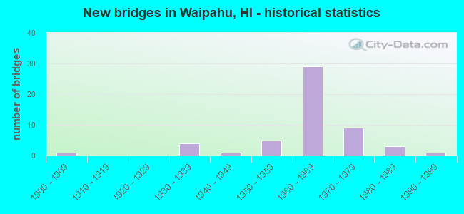
- New bridges - historical statistics
- 11900-1909
- 41930-1939
- 11940-1949
- 51950-1959
- 291960-1969
- 91970-1979
- 31980-1989
- 11990-1999


- Bridge Condition - Deck
- 19.6%Good
- 65.2%Satisfactory
- 15.2%Fair

- Bridge Condition - Superstructure
- 2.1%Very good
- 40.4%Good
- 46.8%Satisfactory
- 10.6%Fair

- Bridge Condition - Substructure
- 55.3%Good
- 38.3%Satisfactory
- 6.4%Fair

- Bridge Condition - Channel
- 3.8%Very good
- 61.5%Good
- 19.2%Satisfactory
- 11.5%Fair
- 3.8%Poor

- Bridge Condition - Culverts
- 16.7%Good
- 16.7%Satisfactory
- 50.0%Fair
- 16.7%Poor
Find on map >> Show street view
Structure Number: 3000990401679, Location: 0.11MI S/BEG DIVIDED HWY (Lat: 21.399808, Lng: -157.992808), Route carried "on" structure: US 99, Year Built: 1953, Status: Open, Structure Length: 1.98m (6.50ft), Average Daily Traffic: 34,200 (year 2017), Truck Traffic: 2%, Average Future Daily Traffic: 47,319 (year 2025), Design Load: HS 20, Features Intersected: CANE HAUL RD (I.B), Facility Carried by Structure: KAM HWY
Minimum Vertical Clearance: 30+ m (98+ ft), Kilometerpoint: 26.988, Lanes on structure: 2, Lanes under structure: 2, Base Highway Network: Yes, Owner: State Highway Agency, Approaching Roadway Width: 12.2m (40.0ft), Skew: 14 degrees, Material/Design: Steel, Design/Construction: Stringer/Multi-beam, Number Of Spans In Main Unit: 1, Length of Maximum Span: 18.3m (60.0ft), Curb or Sidewalk Widths: Left: 0.6m (2.0ft), Right: 1.2m (3.9ft), Curb-To-Curb Width: 8.5m (27.9ft), Out-to-Out Width: 11.1m (36.4ft)
Condition: Deck: Satisfactory, Superstructure: Good, Substructure: Good, Operating Rating: 44.7 metric tons, Method Used To Determine Operating Rating: Load and Resistance Factor Rating (LRFR) rating reported by rating factor(RF) method using HL-93 loadings, Inventory Rating: 34.3 metric tons, Method Used To Determine Inventory Rating: Load and Resistance Factor Rating (LRFR) rating reported by rating factor(RF) method using HL-93 loadings, Structural Evaluation: Better than present minimum criteria, Deck Geometry: High priority of replacement, Underclear: High priority of corrective action, Approach Roadway Alignment: Somewhat better than minimum adequacy, Length Of Structure Improvement: 2.68m (8.79ft), Designated Inspection Frequency: Every 24 months, Inspection Date: December 2020, Bridge Improvement Cost: $3,535,000, Roadway Improvement Cost: $118,000, Total Project Cost: $4,525,000, Deck Structure Type: Concrete Cast-file-Place
Find on map >> Show street view
Structure Number: 3000990401688, Location: 0.05MI S/RD TO WAIPAHU (Lat: 21.398022, Lng: -157.991858), Route carried "on" structure: US 99, Year Built: 1968, Status: Open, Structure Length: 14.90m (48.88ft), Average Daily Traffic: 13,700 (year 2017), Truck Traffic: 2%, Average Future Daily Traffic: 50,323 (year 2025), Design Load: HS 20, Features Intersected: FAI-H1 WAIAWA IC #4B, Facility Carried by Structure: KAM HWY
Minimum Vertical Clearance: 30+ m (98+ ft), Kilometerpoint: 27.149, Lanes on structure: 2, Lanes under structure: 8, Base Highway Network: Yes, Owner: State Highway Agency, Approaching Roadway Width: 11.0m (36.1ft), Skew: 2 degrees, Material/Design: Concrete continuous, Design/Construction: Box Beam or Girders - Multiple, Number Of Spans In Main Unit: 5, Length of Maximum Span: 38.1m (125.0ft), Curb-To-Curb Width: 10.4m (34.1ft), Out-to-Out Width: 11.4m (37.4ft)
Condition: Deck: Fair, Superstructure: Fair, Substructure: Satisfactory, Operating Rating: 24.0 metric tons, Method Used To Determine Operating Rating: Load and Resistance Factor Rating (LRFR) rating reported by rating factor(RF) method using HL-93 loadings, Inventory Rating: 18.5 metric tons, Method Used To Determine Inventory Rating: Load and Resistance Factor Rating (LRFR) rating reported by rating factor(RF) method using HL-93 loadings, Structural Evaluation: Meets minimum limits, Deck Geometry: Meets minimum limits, Underclear: Equal to present desirable criteria, Approach Roadway Alignment: Somewhat better than minimum adequacy, Designated Inspection Frequency: Every 24 months, Inspection Date: December 2020, Deck Structure Type: Concrete Cast-file-Place
Find on map >> Show street view
Structure Number: 3000990401689, Location: 0.05MI S/RD TO WAIPAHU (Lat: 21.397961, Lng: -157.991642), Route carried "on" structure: US 99, Year Built: 1968, Status: Open, Structure Length: 14.90m (48.88ft), Average Daily Traffic: 13,700 (year 2017), Truck Traffic: 2%, Average Future Daily Traffic: 50,323 (year 2025), Design Load: HS 20, Features Intersected: FAI-H1 WAIAWA IC #4A, Facility Carried by Structure: KAM HWY
Minimum Vertical Clearance: 30+ m (98+ ft), Kilometerpoint: 27.165, Lanes on structure: 2, Lanes under structure: 8, Base Highway Network: Yes, Owner: State Highway Agency, Approaching Roadway Width: 11.0m (36.1ft), Skew: 2 degrees, Material/Design: Concrete continuous, Design/Construction: Box Beam or Girders - Multiple, Number Of Spans In Main Unit: 5, Length of Maximum Span: 38.1m (125.0ft), Curb-To-Curb Width: 10.4m (34.1ft), Out-to-Out Width: 11.4m (37.4ft)
Condition: Deck: Fair, Superstructure: Fair, Substructure: Satisfactory, Operating Rating: 22.7 metric tons, Method Used To Determine Operating Rating: Load and Resistance Factor Rating (LRFR) rating reported by rating factor(RF) method using HL-93 loadings, Inventory Rating: 17.5 metric tons, Method Used To Determine Inventory Rating: Load and Resistance Factor Rating (LRFR) rating reported by rating factor(RF) method using HL-93 loadings, Structural Evaluation: Meets minimum limits, Deck Geometry: Meets minimum limits, Underclear: Better than present minimum criteria, Approach Roadway Alignment: Somewhat better than minimum adequacy, Length Of Structure Improvement: 15.68m (51.44ft), Designated Inspection Frequency: Every 24 months, Inspection Date: December 2020, Roadway Improvement Cost: $147,000, Total Project Cost: $2,198,000, Deck Structure Type: Concrete Cast-file-Place
Find on map >> Show street view
Structure Number: 3000990401724, Location: 0.08MI S/RAMP E (Lat: 21.393914, Lng: -157.989392), Route carried "on" structure: US 99, Year Built: 1969, Status: Open, Structure Length: 5.64m (18.50ft), Average Daily Traffic: 13,700 (year 2017), Truck Traffic: 2%, Average Future Daily Traffic: 50,323 (year 2025), Design Load: HS 20, Features Intersected: FARR HWY-WAIAWA IC #10A, Facility Carried by Structure: KAM HWY
Minimum Vertical Clearance: 30+ m (98+ ft), Kilometerpoint: 27.712, Lanes on structure: 1, Lanes under structure: 4, Base Highway Network: Yes, Owner: State Highway Agency, Approaching Roadway Width: 26.2m (86.0ft), Skew: 11 degrees, Material/Design: Prestressed concrete, Design/Construction: Stringer/Multi-beam, Number Of Spans In Main Unit: 2, Length of Maximum Span: 27.4m (89.9ft), Curb-To-Curb Width: 7.0m (23.0ft), Out-to-Out Width: 11.1m (36.4ft)
Condition: Deck: Satisfactory, Superstructure: Satisfactory, Substructure: Satisfactory, Operating Rating: 73.5 metric tons, Method Used To Determine Operating Rating: Load and Resistance Factor Rating (LRFR) rating reported by rating factor(RF) method using HL-93 loadings, Inventory Rating: 26.9 metric tons, Method Used To Determine Inventory Rating: Load and Resistance Factor Rating (LRFR) rating reported by rating factor(RF) method using HL-93 loadings, Structural Evaluation: Equal to present minimum criteria, Deck Geometry: High priority of replacement, Underclear: Better than present minimum criteria, Approach Roadway Alignment: Equal to present desirable criteria, Length Of Structure Improvement: 6.68m (21.92ft), Designated Inspection Frequency: Every 24 months, Inspection Date: December 2020, Roadway Improvement Cost: $61,000, Total Project Cost: $911,000, Deck Structure Type: Concrete Cast-file-Place
Find on map >> Show street view
Structure Number: 3000990401725, Location: 0.08MI S/RAMP D-1 (Lat: 21.393831, Lng: -157.989508), Route carried "on" structure: US 99, Year Built: 1969, Status: Open, Structure Length: 5.64m (18.50ft), Average Daily Traffic: 13,700 (year 2017), Truck Traffic: 2%, Average Future Daily Traffic: 50,323 (year 2025), Design Load: HS 20, Features Intersected: FARR HWY-WAIAWA IC #10B, Facility Carried by Structure: KAM HWY
Minimum Vertical Clearance: 30+ m (98+ ft), Kilometerpoint: 27.728, Lanes on structure: 2, Lanes under structure: 4, Base Highway Network: Yes, Owner: State Highway Agency, Approaching Roadway Width: 11.6m (38.1ft), Skew: 11 degrees, Material/Design: Prestressed concrete, Design/Construction: Stringer/Multi-beam, Number Of Spans In Main Unit: 2, Length of Maximum Span: 27.4m (89.9ft), Curb-To-Curb Width: 10.1m (33.1ft), Out-to-Out Width: 11.1m (36.4ft)
Condition: Deck: Satisfactory, Superstructure: Satisfactory, Substructure: Good, Operating Rating: 56.7 metric tons, Method Used To Determine Operating Rating: Load and Resistance Factor Rating (LRFR) rating reported by rating factor(RF) method using HL-93 loadings, Inventory Rating: 27.2 metric tons, Method Used To Determine Inventory Rating: Load and Resistance Factor Rating (LRFR) rating reported by rating factor(RF) method using HL-93 loadings, Structural Evaluation: Equal to present minimum criteria, Deck Geometry: High priority of corrective action, Underclear: Equal to present minimum criteria, Approach Roadway Alignment: Meets minimum limits, Length Of Structure Improvement: 6.68m (21.92ft), Designated Inspection Frequency: Every 24 months, Inspection Date: December 2020, Roadway Improvement Cost: $61,000, Total Project Cost: $911,000, Deck Structure Type: Concrete Cast-file-Place
Find on map >> Show street view
Structure Number: 3000990401745, Location: 0.39MI W/FARR HWY (Lat: 21.398275, Lng: -157.984586), Route carried "on" structure: US 99, Year Built: 1949, Status: Open, Structure Length: 5.94m (19.49ft), Average Daily Traffic: 13,700 (year 2017), Truck Traffic: 2%, Average Future Daily Traffic: 50,323 (year 2025), Design Load: H 20, Features Intersected: WAIAWA STRM (E.B), Facility Carried by Structure: OLD KAM HWY
Minimum Vertical Clearance: 30+ m (98+ ft), Kilometerpoint: 28.082, Lanes on structure: 2, Base Highway Network: Yes, Owner: State Highway Agency, Approaching Roadway Width: 13.1m (43.0ft), Skew: 14 degrees, Material/Design: Concrete continuous, Design/Construction: Tee Beam, Number Of Spans In Main Unit: 7, Length of Maximum Span: 11.0m (36.1ft), Curb or Sidewalk Widths: Left: 0.6m (2.0ft), Right: 1.2m (3.9ft), Curb-To-Curb Width: 8.5m (27.9ft), Out-to-Out Width: 11.1m (36.4ft)
Condition: Deck: Satisfactory, Superstructure: Satisfactory, Substructure: Satisfactory, Channel: Fair, Operating Rating: 44.1 metric tons, Method Used To Determine Operating Rating: Load and Resistance Factor Rating (LRFR) rating reported by rating factor(RF) method using HL-93 loadings, Inventory Rating: 34.0 metric tons, Method Used To Determine Inventory Rating: Load and Resistance Factor Rating (LRFR) rating reported by rating factor(RF) method using HL-93 loadings, Structural Evaluation: Equal to present minimum criteria, Deck Geometry: High priority of corrective action, Waterway Adequacy: Somewhat better than minimum adequacy, Approach Roadway Alignment: Somewhat better than minimum adequacy, Length Of Structure Improvement: 6.98m (22.90ft), Designated Inspection Frequency: Every 24 months, Inspection Date: December 2020, Roadway Improvement Cost: $64,000, Total Project Cost: $953,000, Deck Structure Type: Concrete Cast-file-Place, Wearing Surface/Protective System: Wearing Surface: Bituminous
Find on map >> Show street view
Structure Number: 3000990401746, Location: 0.39MI W/FARR HWY (Lat: 21.398428, Lng: -157.984667), Route carried "on" structure: US 99, Year Built: 1953, Status: Open, Structure Length: 5.91m (19.39ft), Average Daily Traffic: 13,700 (year 2017), Truck Traffic: 2%, Average Future Daily Traffic: 50,323 (year 2025), Design Load: HS 20, Features Intersected: WAIAWA STRM (W.B), Facility Carried by Structure: OLD KAM HWY
Minimum Vertical Clearance: 30+ m (98+ ft), Kilometerpoint: 28.098, Lanes on structure: 2, Base Highway Network: Yes, Owner: State Highway Agency, Approaching Roadway Width: 14.6m (47.9ft), Skew: 11 degrees, Material/Design: Concrete continuous, Design/Construction: Tee Beam, Number Of Spans In Main Unit: 7, Length of Maximum Span: 11.0m (36.1ft), Curb or Sidewalk Widths: Left: 0.6m (2.0ft), Right: 1.2m (3.9ft), Curb-To-Curb Width: 8.5m (27.9ft), Out-to-Out Width: 11.2m (36.7ft)
Condition: Deck: Satisfactory, Superstructure: Satisfactory, Substructure: Fair, Channel: Poor, Operating Rating: 46.3 metric tons, Method Used To Determine Operating Rating: Load and Resistance Factor Rating (LRFR) rating reported by rating factor(RF) method using HL-93 loadings, Inventory Rating: 36.0 metric tons, Method Used To Determine Inventory Rating: Load and Resistance Factor Rating (LRFR) rating reported by rating factor(RF) method using HL-93 loadings, Structural Evaluation: Somewhat better than minimum adequacy, Deck Geometry: High priority of corrective action, Waterway Adequacy: Better than present minimum criteria, Approach Roadway Alignment: Somewhat better than minimum adequacy, Length Of Structure Improvement: 6.95m (22.80ft), Designated Inspection Frequency: Every 24 months, Inspection Date: December 2020, Roadway Improvement Cost: $64,000, Total Project Cost: $957,000, Deck Structure Type: Concrete Cast-file-Place
Find on map >> Show street view
Structure Number: 3000990401802, Location: 0.12MI E/LEEWARD COLL ACC (Lat: 21.396406, Lng: -157.980097), Route carried "on" structure: US 99, Year Built: 1933, Status: Open, Structure Length: 10.12m (33.20ft), Average Daily Traffic: 59,100 (year 2017), Truck Traffic: 3%, Average Future Daily Traffic: 52,385 (year 2025), Design Load: H 15, Features Intersected: WAIAWA STRM(WEST BN), Facility Carried by Structure: FARR HWY
Minimum Vertical Clearance: 30+ m (98+ ft), Kilometerpoint: 29.000, Lanes on structure: 2, Base Highway Network: Yes, Owner: State Highway Agency, Approaching Roadway Width: 11.9m (39.0ft), Material/Design: Concrete continuous, Design/Construction: Tee Beam, Number Of Spans In Main Unit: 6, Length of Maximum Span: 16.8m (55.1ft), Curb-To-Curb Width: 9.2m (30.2ft), Out-to-Out Width: 10.3m (33.8ft)
Condition: Deck: Satisfactory, Superstructure: Satisfactory, Substructure: Satisfactory, Channel: Fair, Operating Rating: 32.7 metric tons, Method Used To Determine Operating Rating: Load and Resistance Factor Rating (LRFR) rating reported by rating factor(RF) method using HL-93 loadings, Inventory Rating: 25.3 metric tons, Method Used To Determine Inventory Rating: Load and Resistance Factor Rating (LRFR) rating reported by rating factor(RF) method using HL-93 loadings, Structural Evaluation: Equal to present minimum criteria, Deck Geometry: Meets minimum limits, Waterway Adequacy: Better than present minimum criteria, Approach Roadway Alignment: Equal to present minimum criteria, Length Of Structure Improvement: 11.13m (36.52ft), Designated Inspection Frequency: Every 24 months, Inspection Date: December 2020, Total Project Cost: $8,213,000, Deck Structure Type: Concrete Cast-file-Place
Find on map >> Show street view
Structure Number: 3000990401804, Location: 0.04MI E/LEEWARD COLL ACC (Lat: 21.395636, Lng: -157.978611), Route carried "on" structure: US 99, Year Built: 1952, Status: Open, Structure Length: 6.10m (20.01ft), Average Daily Traffic: 59,100 (year 2017), Truck Traffic: 3%, Average Future Daily Traffic: 52,385 (year 2025), Design Load: HS 20, Features Intersected: WAIAWA STRM(EAST BN), Facility Carried by Structure: FARR HWY
Minimum Vertical Clearance: 30+ m (98+ ft), Kilometerpoint: 29.032, Lanes on structure: 2, Base Highway Network: Yes, Owner: State Highway Agency, Approaching Roadway Width: 11.9m (39.0ft), Material/Design: Concrete continuous, Design/Construction: Tee Beam, Number Of Spans In Main Unit: 3, Length of Maximum Span: 22.9m (75.1ft), Curb or Sidewalk Widths: Left: 0.6m (2.0ft), Right: 1.2m (3.9ft), Curb-To-Curb Width: 8.5m (27.9ft), Out-to-Out Width: 11.1m (36.4ft)
Condition: Deck: Satisfactory, Superstructure: Satisfactory, Substructure: Satisfactory, Channel: Satisfactory, Operating Rating: 44.7 metric tons, Method Used To Determine Operating Rating: Load and Resistance Factor Rating (LRFR) rating reported by rating factor(RF) method using HL-93 loadings, Inventory Rating: 34.7 metric tons, Method Used To Determine Inventory Rating: Load and Resistance Factor Rating (LRFR) rating reported by rating factor(RF) method using HL-93 loadings, Structural Evaluation: Equal to present minimum criteria, Deck Geometry: High priority of corrective action, Waterway Adequacy: Equal to present minimum criteria, Approach Roadway Alignment: Equal to present minimum criteria, Length Of Structure Improvement: 7.14m (23.43ft), Designated Inspection Frequency: Every 24 months, Inspection Date: December 2020, Roadway Improvement Cost: $65,000, Total Project Cost: $975,000, Deck Structure Type: Concrete Cast-file-Place, Wearing Surface/Protective System: Wearing Surface: Bituminous
Find on map >> Show street view
Structure Number: 3000990401815, Location: 0.25MI E/LEEWARD COLL ACC (Lat: 21.396478, Lng: -157.978744), Route carried "on" structure: US 99, Year Built: 1953, Status: Open, Structure Length: 4.69m (15.39ft), Average Daily Traffic: 59,100 (year 2017), Truck Traffic: 3%, Average Future Daily Traffic: 52,385 (year 2025), Design Load: HS 20, Features Intersected: WAIAWA SEP(HWY UP), Facility Carried by Structure: KAM HWY
Minimum Vertical Clearance: 5.11m (16.77ft), Kilometerpoint: 29.209, Lanes on structure: 2, Lanes under structure: 2, Base Highway Network: Yes, Owner: State Highway Agency, Approaching Roadway Width: 10.4m (34.1ft), Material/Design: Concrete continuous, Design/Construction: Tee Beam, Number Of Spans In Main Unit: 3, Length of Maximum Span: 20.1m (65.9ft), Curb or Sidewalk Widths: Left: 0.6m (2.0ft), Right: 1.2m (3.9ft), Curb-To-Curb Width: 8.5m (27.9ft), Out-to-Out Width: 12.1m (39.7ft)
Condition: Deck: Satisfactory, Superstructure: Satisfactory, Substructure: Satisfactory, Operating Rating: 37.3 metric tons, Method Used To Determine Operating Rating: Load and Resistance Factor Rating (LRFR) rating reported by rating factor(RF) method using HL-93 loadings, Inventory Rating: 28.5 metric tons, Method Used To Determine Inventory Rating: Load and Resistance Factor Rating (LRFR) rating reported by rating factor(RF) method using HL-93 loadings, Structural Evaluation: Equal to present minimum criteria, Deck Geometry: High priority of corrective action, Underclear: Meets minimum limits, Approach Roadway Alignment: Somewhat better than minimum adequacy, Length Of Structure Improvement: 5.64m (18.50ft), Designated Inspection Frequency: Every 24 months, Inspection Date: December 2020, Total Project Cost: $4,995,000, Deck Structure Type: Concrete Cast-file-Place
Find on map >> Show street view
Structure Number: 3000H10100537, Location: 2.21MI E/PALEHUA RD (Lat: 21.383667, Lng: -158.032056), Route carried "on" structure: Interstate H1, Year Built: 1967, Status: Open, Structure Length: 5.00m (16.40ft), Average Daily Traffic: 119,500 (year 2017), Truck Traffic: 5%, Average Future Daily Traffic: 118,342 (year 2025), Design Load: HS 20, Features Intersected: KUNIA SEP IB
Minimum Vertical Clearance: 30+ m (98+ ft), Kilometerpoint: 8.642, Lanes on structure: 3, Lanes under structure: 3, Base Highway Network: Yes, Owner: State Highway Agency, Approaching Roadway Width: 15.2m (49.9ft), Skew: 10 degrees, Material/Design: Prestressed concrete, Design/Construction: Stringer/Multi-beam, Number Of Spans In Main Unit: 2, Length of Maximum Span: 24.4m (80.1ft), Curb-To-Curb Width: 15.4m (50.5ft), Out-to-Out Width: 16.6m (54.5ft)
Condition: Deck: Satisfactory, Superstructure: Good, Substructure: Good, Operating Rating: 65.1 metric tons, Method Used To Determine Operating Rating: Load and Resistance Factor Rating (LRFR) rating reported by rating factor(RF) method using HL-93 loadings, Inventory Rating: 33.0 metric tons, Method Used To Determine Inventory Rating: Load and Resistance Factor Rating (LRFR) rating reported by rating factor(RF) method using HL-93 loadings, Structural Evaluation: Better than present minimum criteria, Deck Geometry: Somewhat better than minimum adequacy, Underclear: Somewhat better than minimum adequacy, Approach Roadway Alignment: Equal to present minimum criteria, Designated Inspection Frequency: Every 24 months, Inspection Date: March 2020, Total Project Cost: $1,464,000, Deck Structure Type: Concrete Cast-file-Place
Find on map >> Show street view
Structure Number: 3000H10100538, Location: 2.21MI E/PALEHUA RD (Lat: 21.383839, Lng: -158.032206), Route carried "on" structure: Interstate H1, Year Built: 1967, Status: Open, Structure Length: 5.00m (16.40ft), Average Daily Traffic: 119,500 (year 2017), Truck Traffic: 5%, Average Future Daily Traffic: 118,342 (year 2025), Design Load: HS 20, Features Intersected: KUNIA SEP OB
Minimum Vertical Clearance: 30+ m (98+ ft), Kilometerpoint: 8.658, Lanes on structure: 4, Lanes under structure: 3, Base Highway Network: Yes, Owner: State Highway Agency, Approaching Roadway Width: 18.9m (62.0ft), Skew: 10 degrees, Material/Design: Prestressed concrete, Design/Construction: Stringer/Multi-beam, Number Of Spans In Main Unit: 2, Length of Maximum Span: 24.4m (80.1ft), Curb-To-Curb Width: 19.1m (62.7ft), Out-to-Out Width: 20.3m (66.6ft)
Condition: Deck: Satisfactory, Superstructure: Good, Substructure: Good, Operating Rating: 64.8 metric tons, Method Used To Determine Operating Rating: Load and Resistance Factor Rating (LRFR) rating reported by rating factor(RF) method using HL-93 loadings, Inventory Rating: 33.7 metric tons, Method Used To Determine Inventory Rating: Load and Resistance Factor Rating (LRFR) rating reported by rating factor(RF) method using HL-93 loadings, Structural Evaluation: Better than present minimum criteria, Deck Geometry: Somewhat better than minimum adequacy, Underclear: Somewhat better than minimum adequacy, Approach Roadway Alignment: Equal to present minimum criteria, Designated Inspection Frequency: Every 24 months, Inspection Date: March 2020, Total Project Cost: $1,923,000, Deck Structure Type: Concrete Cast-file-Place
Find on map >> Show street view
Structure Number: 3000H10100586, Location: 0.49MI E/KUNIA RD (Lat: 21.387497, Lng: -158.025747), Route carried "on" structure: Interstate H1, Year Built: 1967, Status: Open, Structure Length: 1.52m (4.99ft), Average Daily Traffic: 174,200 (year 2017), Truck Traffic: 4%, Average Future Daily Traffic: 176,247 (year 2025), Design Load: HS 20, Features Intersected: STRM-TRPL 168" STL PL
Minimum Vertical Clearance: 30+ m (98+ ft), Kilometerpoint: 9.430, Lanes on structure: 8, Base Highway Network: Yes, Owner: State Highway Agency, Approaching Roadway Width: 47.5m (155.8ft), Skew: 21 degrees, Material/Design: Steel, Design/Construction: Culvert, Number Of Spans In Main Unit: 3, Length of Maximum Span: 4.3m (14.1ft), Curb-To-Curb Width: 47.5m (155.8ft), Out-to-Out Width: 49.4m (162.1ft)
Condition: Channel: Good, Culverts: Fair, Operating Rating: 43.5 metric tons, Method Used To Determine Operating Rating: Allowable Stress (AS), Inventory Rating: 32.7 metric tons, Method Used To Determine Inventory Rating: Allowable Stress (AS), Structural Evaluation: Somewhat better than minimum adequacy, Deck Geometry: Superior to present desirable criteria, Waterway Adequacy: Equal to present desirable criteria, Approach Roadway Alignment: Equal to present minimum criteria, Designated Inspection Frequency: Every 24 months, Inspection Date: December 2020, Roadway Improvement Cost: $89,000, Total Project Cost: $1,337,000, Wearing Surface/Protective System: Wearing Surface: Bituminous
Find on map >> Show street view
Structure Number: 3000H10100604, Location: 0.67MI E/KUNIA RD (Lat: 21.388678, Lng: -158.023175), Route carried "on" structure: Interstate H1, Year Built: 1967, Status: Open, Structure Length: 3.17m (10.40ft), Average Daily Traffic: 174,200 (year 2017), Truck Traffic: 4%, Average Future Daily Traffic: 176,247 (year 2025), Design Load: HS 20, Features Intersected: AIKI SEP IB (HOAEAE)
Minimum Vertical Clearance: 30+ m (98+ ft), Kilometerpoint: 9.736, Lanes on structure: 4, Lanes under structure: 2, Base Highway Network: Yes, Owner: State Highway Agency, Approaching Roadway Width: 21.9m (71.9ft), Skew: 11 degrees, Material/Design: Prestressed concrete, Design/Construction: Stringer/Multi-beam, Number Of Spans In Main Unit: 1, Length of Maximum Span: 30.5m (100.1ft), Curb or Sidewalk Widths: Left: 0.5m (1.6ft), Right: 0.5m (1.6ft), Curb-To-Curb Width: 18.9m (62.0ft), Out-to-Out Width: 20.6m (67.6ft)
Condition: Deck: Fair, Superstructure: Satisfactory, Substructure: Satisfactory, Operating Rating: 40.8 metric tons, Method Used To Determine Operating Rating: Allowable Stress (AS), Inventory Rating: 25.4 metric tons, Method Used To Determine Inventory Rating: Allowable Stress (AS), Structural Evaluation: Equal to present minimum criteria, Deck Geometry: Meets minimum limits, Underclear: High priority of corrective action, Approach Roadway Alignment: Equal to present desirable criteria, Designated Inspection Frequency: Every 24 months, Inspection Date: December 2020, Deck Structure Type: Concrete Cast-file-Place
Find on map >> Show street view
Structure Number: 3000H10100605, Location: 0.67MI E/KUNIA RD (Lat: 21.388917, Lng: -158.023267), Route carried "on" structure: Interstate H1, Year Built: 1967, Status: Open, Structure Length: 3.17m (10.40ft), Average Daily Traffic: 174,200 (year 2017), Truck Traffic: 4%, Average Future Daily Traffic: 176,247 (year 2025), Design Load: HS 20, Features Intersected: AIKI SEP OB (HOAEAE)
Minimum Vertical Clearance: 30+ m (98+ ft), Kilometerpoint: 9.752, Lanes on structure: 4, Lanes under structure: 2, Base Highway Network: Yes, Owner: State Highway Agency, Approaching Roadway Width: 21.9m (71.9ft), Skew: 11 degrees, Material/Design: Prestressed concrete, Design/Construction: Stringer/Multi-beam, Number Of Spans In Main Unit: 1, Length of Maximum Span: 30.5m (100.1ft), Curb or Sidewalk Widths: Left: 0.5m (1.6ft), Right: 0.5m (1.6ft), Curb-To-Curb Width: 18.9m (62.0ft), Out-to-Out Width: 20.6m (67.6ft)
Condition: Deck: Satisfactory, Superstructure: Fair, Substructure: Satisfactory, Operating Rating: 40.8 metric tons, Method Used To Determine Operating Rating: Allowable Stress (AS), Inventory Rating: 25.4 metric tons, Method Used To Determine Inventory Rating: Allowable Stress (AS), Structural Evaluation: Somewhat better than minimum adequacy, Deck Geometry: Meets minimum limits, Underclear: High priority of corrective action, Approach Roadway Alignment: Equal to present desirable criteria, Designated Inspection Frequency: Every 24 months, Inspection Date: December 2020, Deck Structure Type: Concrete Cast-file-Place
Find on map >> Show street view
Structure Number: 3000H10100635, Location: 0.97MI E/KUNIA RD (Lat: 21.390731, Lng: -158.017844), Route carried "on" structure: Interstate H1, Year Built: 1968, Status: Open, Structure Length: 26.70m (87.60ft), Average Daily Traffic: 174,200 (year 2017), Truck Traffic: 4%, Average Future Daily Traffic: 176,247 (year 2025), Design Load: HS 20, Features Intersected: WAIKELE STRM IB
Minimum Vertical Clearance: 30+ m (98+ ft), Kilometerpoint: 10.219, Lanes on structure: 4, Base Highway Network: Yes, Owner: State Highway Agency, Approaching Roadway Width: 21.3m (69.9ft), Skew: 10 degrees, Material/Design: Prestressed concrete, Design/Construction: Stringer/Multi-beam, Number Of Spans In Main Unit: 9, Number Of Approach Spans: 1, Length of Maximum Span: 29.0m (95.1ft), Curb-To-Curb Width: 19.3m (63.3ft), Out-to-Out Width: 20.3m (66.6ft)
Condition: Deck: Satisfactory, Superstructure: Satisfactory, Substructure: Good, Channel: Good, Operating Rating: 40.8 metric tons, Method Used To Determine Operating Rating: Allowable Stress (AS), Inventory Rating: 24.5 metric tons, Method Used To Determine Inventory Rating: Allowable Stress (AS), Structural Evaluation: Equal to present minimum criteria, Deck Geometry: Somewhat better than minimum adequacy, Waterway Adequacy: Better than present minimum criteria, Approach Roadway Alignment: Equal to present desirable criteria, Designated Inspection Frequency: Every 24 months, Inspection Date: January 2021, Deck Structure Type: Concrete Cast-file-Place
Find on map >> Show street view
Structure Number: 3000H10100636, Location: 0.97MI E/KUNIA RD (Lat: 21.390989, Lng: -158.017911), Route carried "on" structure: Interstate H1, Year Built: 1968, Status: Open, Structure Length: 25.36m (83.20ft), Average Daily Traffic: 174,200 (year 2017), Truck Traffic: 4%, Average Future Daily Traffic: 176,247 (year 2025), Design Load: HS 20, Features Intersected: WAIKELE STRM OB
Minimum Vertical Clearance: 30+ m (98+ ft), Kilometerpoint: 10.235, Lanes on structure: 4, Base Highway Network: Yes, Owner: State Highway Agency, Approaching Roadway Width: 20.7m (67.9ft), Skew: 10 degrees, Material/Design: Prestressed concrete, Design/Construction: Stringer/Multi-beam, Number Of Spans In Main Unit: 9, Length of Maximum Span: 29.0m (95.1ft), Curb-To-Curb Width: 19.3m (63.3ft), Out-to-Out Width: 20.3m (66.6ft)
Condition: Deck: Satisfactory, Superstructure: Satisfactory, Substructure: Good, Channel: Good, Operating Rating: 73.5 metric tons, Method Used To Determine Operating Rating: Load and Resistance Factor Rating (LRFR) rating reported by rating factor(RF) method using HL-93 loadings, Inventory Rating: 39.5 metric tons, Method Used To Determine Inventory Rating: Load and Resistance Factor Rating (LRFR) rating reported by rating factor(RF) method using HL-93 loadings, Structural Evaluation: Equal to present minimum criteria, Deck Geometry: Somewhat better than minimum adequacy, Waterway Adequacy: Better than present minimum criteria, Approach Roadway Alignment: Equal to present desirable criteria, Designated Inspection Frequency: Every 24 months, Inspection Date: January 2021, Deck Structure Type: Concrete Cast-file-Place
Find on map >> Show street view
Structure Number: 3000H10100707, Location: 0.30MI E/MANAGERS DR (Lat: 21.396131, Lng: -158.009561), Route carried "on" structure: Interstate H1, Year Built: 1968, Status: Open, Structure Length: 6.10m (20.01ft), Average Daily Traffic: 151,600 (year 2017), Truck Traffic: 4%, Average Future Daily Traffic: 152,698 (year 2025), Design Load: HS 20, Features Intersected: CANE HAUL RD 414 IB
Minimum Vertical Clearance: 30+ m (98+ ft), Kilometerpoint: 11.378, Lanes on structure: 4, Lanes under structure: 2, Base Highway Network: Yes, Owner: State Highway Agency, Approaching Roadway Width: 21.3m (69.9ft), Skew: 11 degrees, Material/Design: Concrete continuous, Design/Construction: Tee Beam, Number Of Spans In Main Unit: 4, Length of Maximum Span: 19.8m (65.0ft), Curb-To-Curb Width: 21.1m (69.2ft), Out-to-Out Width: 22.2m (72.8ft)
Condition: Deck: Fair, Superstructure: Satisfactory, Substructure: Satisfactory, Operating Rating: 57.2 metric tons, Method Used To Determine Operating Rating: Allowable Stress (AS), Inventory Rating: 35.4 metric tons, Method Used To Determine Inventory Rating: Allowable Stress (AS), Structural Evaluation: Equal to present minimum criteria, Deck Geometry: Better than present minimum criteria, Underclear: High priority of corrective action, Approach Roadway Alignment: Equal to present desirable criteria, Designated Inspection Frequency: Every 24 months, Inspection Date: December 2020, Deck Structure Type: Concrete Cast-file-Place
Find on map >> Show street view
Structure Number: 3000H10100708, Location: 0.30MI E/MANAGERS DR (Lat: 21.396381, Lng: -158.009667), Route carried "on" structure: Interstate H1, Year Built: 1968, Status: Open, Structure Length: 6.10m (20.01ft), Average Daily Traffic: 151,600 (year 2017), Truck Traffic: 4%, Average Future Daily Traffic: 152,698 (year 2025), Design Load: HS 20, Features Intersected: CANE HAUL RD 414 OB
Minimum Vertical Clearance: 30+ m (98+ ft), Kilometerpoint: 11.394, Lanes on structure: 4, Lanes under structure: 2, Base Highway Network: Yes, Owner: State Highway Agency, Approaching Roadway Width: 20.7m (67.9ft), Skew: 11 degrees, Material/Design: Concrete continuous, Design/Construction: Tee Beam, Number Of Spans In Main Unit: 4, Length of Maximum Span: 19.8m (65.0ft), Curb-To-Curb Width: 21.1m (69.2ft), Out-to-Out Width: 22.2m (72.8ft)
Condition: Deck: Fair, Superstructure: Satisfactory, Substructure: Satisfactory, Operating Rating: 57.2 metric tons, Method Used To Determine Operating Rating: Allowable Stress (AS), Inventory Rating: 35.4 metric tons, Method Used To Determine Inventory Rating: Allowable Stress (AS), Structural Evaluation: Equal to present minimum criteria, Deck Geometry: Better than present minimum criteria, Underclear: High priority of corrective action, Approach Roadway Alignment: Equal to present desirable criteria, Designated Inspection Frequency: Every 24 months, Inspection Date: December 2020, Deck Structure Type: Concrete Cast-file-Place
Find on map >> Show street view
Structure Number: 3000H10100775, Location: 0.98MI E/MANAGERS DR (Lat: 21.399053, Lng: -157.999842), Route carried "on" structure: Interstate H1, Year Built: 1968, Status: Open, Structure Length: 4.82m (15.81ft), Average Daily Traffic: 171,500 (year 2017), Truck Traffic: 4%, Average Future Daily Traffic: 152,698 (year 2025), Design Load: HS 20, Features Intersected: CANE HAUL RD 451 IB
Minimum Vertical Clearance: 30+ m (98+ ft), Kilometerpoint: 12.472, Lanes on structure: 4, Lanes under structure: 2, Base Highway Network: Yes, Owner: State Highway Agency, Approaching Roadway Width: 21.3m (69.9ft), Skew: 10 degrees, Material/Design: Prestressed concrete, Design/Construction: Stringer/Multi-beam, Number Of Spans In Main Unit: 3, Length of Maximum Span: 26.2m (86.0ft), Curb-To-Curb Width: 21.1m (69.2ft), Out-to-Out Width: 22.2m (72.8ft)
Condition: Deck: Satisfactory, Superstructure: Satisfactory, Substructure: Satisfactory, Channel: Good, Operating Rating: 55.1 metric tons, Method Used To Determine Operating Rating: Load and Resistance Factor Rating (LRFR) rating reported by rating factor(RF) method using HL-93 loadings, Inventory Rating: 32.4 metric tons, Method Used To Determine Inventory Rating: Load and Resistance Factor Rating (LRFR) rating reported by rating factor(RF) method using HL-93 loadings, Structural Evaluation: Equal to present minimum criteria, Deck Geometry: Better than present minimum criteria, Underclear: Superior to present desirable criteria, Waterway Adequacy: Equal to present desirable criteria, Approach Roadway Alignment: Equal to present desirable criteria, Designated Inspection Frequency: Every 24 months, Inspection Date: December 2020, Roadway Improvement Cost: $106,000, Total Project Cost: $1,592,000, Deck Structure Type: Concrete Cast-file-Place
Find on map >> Show street view
Structure Number: 3000H10100776, Location: 0.98MI E/MANAGERS DR (Lat: 21.399306, Lng: -157.999783), Route carried "on" structure: Interstate H1, Year Built: 1968, Status: Open, Structure Length: 4.82m (15.81ft), Average Daily Traffic: 171,500 (year 2017), Truck Traffic: 4%, Average Future Daily Traffic: 152,698 (year 2025), Design Load: HS 20, Features Intersected: CANE HAUL RD 451 OB
Minimum Vertical Clearance: 30+ m (98+ ft), Kilometerpoint: 12.488, Lanes on structure: 4, Lanes under structure: 2, Base Highway Network: Yes, Owner: State Highway Agency, Approaching Roadway Width: 20.7m (67.9ft), Skew: 10 degrees, Material/Design: Prestressed concrete, Design/Construction: Stringer/Multi-beam, Number Of Spans In Main Unit: 3, Length of Maximum Span: 26.2m (86.0ft), Curb-To-Curb Width: 21.1m (69.2ft), Out-to-Out Width: 22.2m (72.8ft)
Condition: Deck: Satisfactory, Superstructure: Good, Substructure: Good, Channel: Good, Operating Rating: 54.1 metric tons, Method Used To Determine Operating Rating: Load and Resistance Factor Rating (LRFR) rating reported by rating factor(RF) method using HL-93 loadings, Inventory Rating: 31.1 metric tons, Method Used To Determine Inventory Rating: Load and Resistance Factor Rating (LRFR) rating reported by rating factor(RF) method using HL-93 loadings, Structural Evaluation: Better than present minimum criteria, Deck Geometry: Better than present minimum criteria, Underclear: High priority of corrective action, Waterway Adequacy: Equal to present desirable criteria, Approach Roadway Alignment: Equal to present desirable criteria, Designated Inspection Frequency: Every 24 months, Inspection Date: December 2020, Roadway Improvement Cost: $106,000, Total Project Cost: $1,592,000, Deck Structure Type: Concrete Cast-file-Place
Find on map >> Show street view
Structure Number: 3000H10200832, Location: 1.55MI E/MANAGERS DR (Lat: 21.398089, Lng: -157.990581), Route carried "on" structure: Interstate H1, Year Built: 1970, Status: Open, Structure Length: 9.14m (29.99ft), Average Daily Traffic: 128,800 (year 2017), Truck Traffic: 4%, Average Future Daily Traffic: 162,194 (year 2025), Design Load: HS 20, Features Intersected: WAIAWA IC #8 FAI-H2
Minimum Vertical Clearance: 30+ m (98+ ft), Kilometerpoint: 13.389, Lanes on structure: 3, Lanes under structure: 2, Base Highway Network: Yes, Owner: State Highway Agency, Approaching Roadway Width: 16.5m (54.1ft), Skew: 26 degrees, Material/Design: Concrete, Design/Construction: Frame, Number Of Spans In Main Unit: 1, Length of Maximum Span: 15.2m (49.9ft), Curb-To-Curb Width: 17.7m (58.1ft), Out-to-Out Width: 18.6m (61.0ft)
Condition: Deck: Satisfactory, Superstructure: Good, Substructure: Good, Operating Rating: 89.8 metric tons, Method Used To Determine Operating Rating: Allowable Stress (AS), Inventory Rating: 49.0 metric tons, Method Used To Determine Inventory Rating: Allowable Stress (AS), Structural Evaluation: Better than present minimum criteria, Deck Geometry: Better than present minimum criteria, Underclear: Superior to present desirable criteria, Approach Roadway Alignment: Equal to present desirable criteria, Designated Inspection Frequency: Every 24 months, Inspection Date: January 2021, Deck Structure Type: Concrete Cast-file-Place, Wearing Surface/Protective System: Wearing Surface: Bituminous
Find on map >> Show street view
Structure Number: 3000H10200854, Location: 1.77MI E/MANAGERS DR (Lat: 21.397842, Lng: -157.987458), Route carried "on" structure: Interstate H1, Year Built: 1971, Status: Open, Structure Length: 10.36m (33.99ft), Average Daily Traffic: 128,800 (year 2017), Truck Traffic: 4%, Average Future Daily Traffic: 162,194 (year 2025), Design Load: HS 20, Features Intersected: WAIAWA IC #5 FAI-H1, Facility Carried by Structure: FAI-H2
Minimum Vertical Clearance: 4.98m (16.34ft), Kilometerpoint: 13.743, Lanes on structure: 2, Lanes under structure: 4, Base Highway Network: Yes, Owner: State Highway Agency, Approaching Roadway Width: 17.7m (58.1ft), Skew: 6 degrees, Material/Design: Concrete continuous, Design/Construction: Box Beam or Girders - Multiple, Number Of Spans In Main Unit: 3, Length of Maximum Span: 39.6m (129.9ft), Curb-To-Curb Width: 11.6m (38.1ft), Out-to-Out Width: 12.6m (41.3ft)
Condition: Deck: Good, Superstructure: Satisfactory, Substructure: Good, Operating Rating: 25.3 metric tons, Method Used To Determine Operating Rating: Load and Resistance Factor Rating (LRFR) rating reported by rating factor(RF) method using HL-93 loadings, Inventory Rating: 19.4 metric tons, Method Used To Determine Inventory Rating: Load and Resistance Factor Rating (LRFR) rating reported by rating factor(RF) method using HL-93 loadings, Structural Evaluation: Meets minimum limits, Deck Geometry: Equal to present minimum criteria, Underclear: Equal to present desirable criteria, Approach Roadway Alignment: Equal to present desirable criteria, Designated Inspection Frequency: Every 24 months, Inspection Date: January 2021, Roadway Improvement Cost: $116,000, Total Project Cost: $1,747,000, Deck Structure Type: Concrete Cast-file-Place
Find on map >> Show street view
Structure Number: 3000H10200865, Location: 1.89MI E/MANAGERS DR (Lat: 21.398044, Lng: -157.986550), Route carried "on" structure: Interstate H1, Year Built: 1971, Status: Open, Structure Length: 2.68m (8.79ft), Average Daily Traffic: 128,800 (year 2017), Truck Traffic: 4%, Average Future Daily Traffic: 162,194 (year 2025), Design Load: HS 20, Features Intersected: WAIAWA IC #6 OLD KAM HWY
Minimum Vertical Clearance: 30+ m (98+ ft), Kilometerpoint: 13.920, Lanes on structure: 2, Lanes under structure: 1, Base Highway Network: Yes, Owner: State Highway Agency, Approaching Roadway Width: 14.6m (47.9ft), Skew: 2 degrees, Material/Design: Prestressed concrete, Design/Construction: Stringer/Multi-beam, Number Of Spans In Main Unit: 1, Length of Maximum Span: 25.9m (85.0ft), Curb-To-Curb Width: 14.4m (47.2ft), Out-to-Out Width: 15.7m (51.5ft)
Condition: Deck: Good, Superstructure: Good, Substructure: Good, Operating Rating: 57.7 metric tons, Method Used To Determine Operating Rating: Load and Resistance Factor Rating (LRFR) rating reported by rating factor(RF) method using HL-93 loadings, Inventory Rating: 44.4 metric tons, Method Used To Determine Inventory Rating: Load and Resistance Factor Rating (LRFR) rating reported by rating factor(RF) method using HL-93 loadings, Structural Evaluation: Better than present minimum criteria, Deck Geometry: Superior to present desirable criteria, Underclear: Superior to present desirable criteria, Approach Roadway Alignment: Equal to present desirable criteria, Designated Inspection Frequency: Every 24 months, Inspection Date: January 2021, Roadway Improvement Cost: $46,000, Total Project Cost: $694,000, Deck Structure Type: Concrete Cast-file-Place
Find on map >> Show street view
Structure Number: 3000H10400875, Location: 0.58MI E/WAIPAHU ST SEP (Lat: 21.396086, Lng: -157.984594), Route carried "on" structure: Alternate US 99, Year Built: 1969, Status: Open, Structure Length: 16.06m (52.69ft), Average Daily Traffic: 19,300 (year 2017), Truck Traffic: 3%, Average Future Daily Traffic: 34,530 (year 2025), Design Load: HS 20, Features Intersected: WAIAWA IC #3A FAI-H1, Facility Carried by Structure: FARR HWY
Minimum Vertical Clearance: 7.62m (25.00ft), Kilometerpoint: 14.081, Lanes on structure: 3, Lanes under structure: 9, Base Highway Network: Yes, Owner: State Highway Agency, Approaching Roadway Width: 11.6m (38.1ft), Skew: 14 degrees, Material/Design: Concrete continuous, Design/Construction: Box Beam or Girders - Multiple, Number Of Spans In Main Unit: 5, Length of Maximum Span: 36.6m (120.1ft), Curb-To-Curb Width: 11.6m (38.1ft), Out-to-Out Width: 12.6m (41.3ft)
Condition: Deck: Satisfactory, Superstructure: Satisfactory, Substructure: Satisfactory, Operating Rating: 53.5 metric tons, Method Used To Determine Operating Rating: Load and Resistance Factor Rating (LRFR) rating reported by rating factor(RF) method using HL-93 loadings, Inventory Rating: 41.1 metric tons, Method Used To Determine Inventory Rating: Load and Resistance Factor Rating (LRFR) rating reported by rating factor(RF) method using HL-93 loadings, Structural Evaluation: Equal to present minimum criteria, Deck Geometry: High priority of replacement, Underclear: Equal to present desirable criteria, Approach Roadway Alignment: Meets minimum limits, Length Of Structure Improvement: 16.86m (55.31ft), Designated Inspection Frequency: Every 24 months, Inspection Date: November 2020, Total Project Cost: $12,443,000, Deck Structure Type: Concrete Cast-file-Place, Wearing Surface/Protective System: Wearing Surface: Bituminous
Find on map >> Show street view
Structure Number: 3000H10400877, Location: 0.60MI E/WAIPAHU ST SEP (Lat: 21.395922, Lng: -157.984500), Route carried "on" structure: Alternate US 99, Year Built: 1969, Status: Open, Structure Length: 16.12m (52.89ft), Average Daily Traffic: 19,300 (year 2017), Truck Traffic: 3%, Average Future Daily Traffic: 34,530 (year 2025), Design Load: HS 20, Features Intersected: WAIAWA IC #3B FAI-H1, Facility Carried by Structure: KAMEHAMEHA HWY
Minimum Vertical Clearance: 7.11m (23.33ft), Kilometerpoint: 14.114, Lanes on structure: 2, Lanes under structure: 9, Base Highway Network: Yes, Owner: State Highway Agency, Approaching Roadway Width: 11.6m (38.1ft), Skew: 12 degrees, Material/Design: Concrete continuous, Design/Construction: Box Beam or Girders - Multiple, Number Of Spans In Main Unit: 5, Length of Maximum Span: 37.2m (122.0ft), Curb-To-Curb Width: 11.6m (38.1ft), Out-to-Out Width: 12.6m (41.3ft)
Condition: Deck: Satisfactory, Superstructure: Satisfactory, Substructure: Satisfactory, Operating Rating: 53.5 metric tons, Method Used To Determine Operating Rating: Load and Resistance Factor Rating (LRFR) rating reported by rating factor(RF) method using HL-93 loadings, Inventory Rating: 41.1 metric tons, Method Used To Determine Inventory Rating: Load and Resistance Factor Rating (LRFR) rating reported by rating factor(RF) method using HL-93 loadings, Structural Evaluation: Equal to present minimum criteria, Deck Geometry: Better than present minimum criteria, Underclear: Better than present minimum criteria, Approach Roadway Alignment: Equal to present minimum criteria, Designated Inspection Frequency: Every 24 months, Inspection Date: November 2020, Roadway Improvement Cost: $174,000, Total Project Cost: $2,614,000, Deck Structure Type: Concrete Cast-file-Place, Wearing Surface/Protective System: Wearing Surface: Bituminous
Find on map >> Show street view
Structure Number: 3000H11100677, Location: 0.43MI E/NAVAL ACC RD (Lat: 21.393075, Lng: -158.013378), Route carried "on" structure: Other road , Year Built: 1968, Status: Open, Structure Length: 6.83m (22.41ft), Average Daily Traffic: 3,500 (year 2007), Average Future Daily Traffic: 4,750 (year 2025), Design Load: HS 20, Features Intersected: FAI-H1(LUMIAINA ST OP), Facility Carried by Structure: LUMIAINA ST.
Minimum Vertical Clearance: 6.71m (22.01ft), Kilometerpoint: 10.895, Lanes on structure: 2, Lanes under structure: 8, Owner: State Highway Agency, Approaching Roadway Width: 46.3m (151.9ft), Material/Design: Concrete continuous, Design/Construction: Box Beam or Girders - Multiple, Number Of Spans In Main Unit: 2, Length of Maximum Span: 36.6m (120.1ft), Curb or Sidewalk Widths: Left: 1.7m (5.6ft), Right: 2.1m (6.9ft), Curb-To-Curb Width: 17.3m (56.8ft), Out-to-Out Width: 17.9m (58.7ft)
Condition: Deck: Satisfactory, Superstructure: Satisfactory, Substructure: Good, Operating Rating: 38.9 metric tons, Method Used To Determine Operating Rating: Load and Resistance Factor Rating (LRFR) rating reported by rating factor(RF) method using HL-93 loadings, Inventory Rating: 30.1 metric tons, Method Used To Determine Inventory Rating: Load and Resistance Factor Rating (LRFR) rating reported by rating factor(RF) method using HL-93 loadings, Structural Evaluation: Equal to present minimum criteria, Deck Geometry: Superior to present desirable criteria, Underclear: Superior to present desirable criteria, Approach Roadway Alignment: Equal to present minimum criteria, Designated Inspection Frequency: Every 24 months, Inspection Date: November 2020, Roadway Improvement Cost: $72,000, Total Project Cost: $1,074,000, Deck Structure Type: Concrete Cast-file-Place
Find on map >> Show street view
Structure Number: 3000H11100817, Location: 1.41MI E/MANAGERS DR (Lat: 21.397950, Lng: -157.993644), Route carried "on" structure: County highway , Year Built: 1968, Status: Open, Structure Length: 10.21m (33.50ft), Average Daily Traffic: 20,000 (year 2007), Average Future Daily Traffic: 25,000 (year 2025), Design Load: HS 20, Features Intersected: FAI-H1(WAIAWA IC #12), Facility Carried by Structure: WAIPAHU ST
Minimum Vertical Clearance: 6.58m (21.59ft), Kilometerpoint: 13.148, Lanes on structure: 2, Lanes under structure: 9, Owner: State Highway Agency, Approaching Roadway Width: 48.2m (158.1ft), Skew: 3 degrees, Material/Design: Concrete continuous, Design/Construction: Box Beam or Girders - Multiple, Number Of Spans In Main Unit: 4, Length of Maximum Span: 30.5m (100.1ft), Curb-To-Curb Width: 11.3m (37.1ft), Out-to-Out Width: 11.9m (39.0ft)
Condition: Deck: Satisfactory, Superstructure: Satisfactory, Substructure: Good, Operating Rating: 37.9 metric tons, Method Used To Determine Operating Rating: Load and Resistance Factor Rating (LRFR) rating reported by rating factor(RF) method using HL-93 loadings, Inventory Rating: 24.3 metric tons, Method Used To Determine Inventory Rating: Load and Resistance Factor Rating (LRFR) rating reported by rating factor(RF) method using HL-93 loadings, Structural Evaluation: Equal to present minimum criteria, Deck Geometry: Somewhat better than minimum adequacy, Underclear: Superior to present desirable criteria, Approach Roadway Alignment: Equal to present desirable criteria, Designated Inspection Frequency: Every 24 months, Inspection Date: November 2020, Roadway Improvement Cost: $109,000, Total Project Cost: $1,629,000, Deck Structure Type: Concrete Cast-file-Place, Wearing Surface/Protective System: Wearing Surface: Bituminous
Find on map >> Show street view
Structure Number: 3000H11100913, Location: 0.96MI E/WAIPAHU ST SEP (Lat: 21.393758, Lng: -157.979839), Route carried "on" structure: Bypass State highway , Year Built: 1969, Status: Open, Structure Length: 7.22m (23.69ft), Average Daily Traffic: 7,000 (year 2007), Average Future Daily Traffic: 6,250 (year 2025), Design Load: HS 20, Features Intersected: WAIAWA IC #1 FAI-H1, Facility Carried by Structure: WAIAWA RD
Minimum Vertical Clearance: 5.11m (16.77ft), Kilometerpoint: 14.693, Lanes on structure: 2, Lanes under structure: 8, Owner: State Highway Agency, Approaching Roadway Width: 41.5m (136.2ft), Material/Design: Concrete continuous, Design/Construction: Box Beam or Girders - Multiple, Number Of Spans In Main Unit: 2, Length of Maximum Span: 37.5m (123.0ft), Curb-To-Curb Width: 11.0m (36.1ft), Out-to-Out Width: 11.7m (38.4ft)
Condition: Deck: Satisfactory, Superstructure: Satisfactory, Substructure: Good, Operating Rating: 48.0 metric tons, Method Used To Determine Operating Rating: Load and Resistance Factor Rating (LRFR) rating reported by rating factor(RF) method using HL-93 loadings, Inventory Rating: 36.9 metric tons, Method Used To Determine Inventory Rating: Load and Resistance Factor Rating (LRFR) rating reported by rating factor(RF) method using HL-93 loadings, Structural Evaluation: Equal to present minimum criteria, Deck Geometry: Meets minimum limits, Underclear: Superior to present desirable criteria, Approach Roadway Alignment: Equal to present desirable criteria, Designated Inspection Frequency: Every 24 months, Inspection Date: November 2020, Roadway Improvement Cost: $79,000, Total Project Cost: $1,187,000, Deck Structure Type: Concrete Cast-file-Place
Find on map >> Show street view
Structure Number: 3000H20200021, Location: 0.19MI S/URBAN BOUNDARY (Lat: 21.401058, Lng: -157.988644), Route carried "on" structure: Interstate H2, Year Built: 1973, Status: Open, Structure Length: 16.76m (54.99ft), Average Daily Traffic: 111,100 (year 2017), Truck Traffic: 2%, Average Future Daily Traffic: 94,604 (year 2025), Design Load: HS 20, Features Intersected: CANEHAUL RD & STRM #16
Minimum Vertical Clearance: 30+ m (98+ ft), Kilometerpoint: 0.338, Lanes on structure: 2, Lanes under structure: 2, Base Highway Network: Yes, Owner: State Highway Agency, Approaching Roadway Width: 9.4m (30.8ft), Material/Design: Prestressed concrete continuous, Design/Construction: Stringer/Multi-beam, Number Of Spans In Main Unit: 6, Length of Maximum Span: 33.5m (109.9ft), Curb-To-Curb Width: 8.5m (27.9ft), Out-to-Out Width: 9.5m (31.2ft)
Condition: Deck: Good, Superstructure: Good, Substructure: Good, Channel: Good, Operating Rating: 59.0 metric tons, Method Used To Determine Operating Rating: Load and Resistance Factor Rating (LRFR) rating reported by rating factor(RF) method using HL-93 loadings, Inventory Rating: 24.9 metric tons, Method Used To Determine Inventory Rating: Load and Resistance Factor Rating (LRFR) rating reported by rating factor(RF) method using HL-93 loadings, Structural Evaluation: Equal to present minimum criteria, Deck Geometry: Meets minimum limits, Underclear: Somewhat better than minimum adequacy, Waterway Adequacy: Better than present minimum criteria, Approach Roadway Alignment: Better than present minimum criteria, Designated Inspection Frequency: Every 24 months, Inspection Date: January 2021, Roadway Improvement Cost: $141,000, Total Project Cost: $2,108,000, Deck Structure Type: Concrete Cast-file-Place
Find on map >> Show street view
Structure Number: 3000H20200022, Location: 0.19MI S/URBAN BOUNDARY (Lat: 21.401203, Lng: -157.987656), Route carried "on" structure: Interstate H2, Year Built: 1974, Status: Open, Structure Length: 16.76m (54.99ft), Average Daily Traffic: 111,100 (year 2017), Truck Traffic: 2%, Average Future Daily Traffic: 94,604 (year 2025), Design Load: HS 20, Features Intersected: CANEHAUL RD&STRM #13
Minimum Vertical Clearance: 30+ m (98+ ft), Kilometerpoint: 0.354, Lanes on structure: 2, Lanes under structure: 2, Base Highway Network: Yes, Owner: State Highway Agency, Approaching Roadway Width: 12.5m (41.0ft), Material/Design: Prestressed concrete continuous, Design/Construction: Stringer/Multi-beam, Number Of Spans In Main Unit: 6, Length of Maximum Span: 30.5m (100.1ft), Curb-To-Curb Width: 11.6m (38.1ft), Out-to-Out Width: 12.6m (41.3ft)
Condition: Deck: Satisfactory, Superstructure: Good, Substructure: Good, Channel: Good, Operating Rating: 72.3 metric tons, Method Used To Determine Operating Rating: Load and Resistance Factor Rating (LRFR) rating reported by rating factor(RF) method using HL-93 loadings, Inventory Rating: 25.3 metric tons, Method Used To Determine Inventory Rating: Load and Resistance Factor Rating (LRFR) rating reported by rating factor(RF) method using HL-93 loadings, Structural Evaluation: Equal to present minimum criteria, Deck Geometry: Somewhat better than minimum adequacy, Underclear: Somewhat better than minimum adequacy, Waterway Adequacy: Better than present minimum criteria, Approach Roadway Alignment: Better than present minimum criteria, Designated Inspection Frequency: Every 24 months, Inspection Date: January 2021, Roadway Improvement Cost: $181,000, Total Project Cost: $2,711,000, Deck Structure Type: Concrete Cast-file-Place
Find on map >> Show street view
Structure Number: 3000H20200023, Location: 0.19MI S/URBAN BOUNDARY (Lat: 21.401186, Lng: -157.988019), Route carried "on" structure: Interstate H2, Year Built: 1974, Status: Open, Structure Length: 15.54m (50.98ft), Average Daily Traffic: 111,100 (year 2017), Truck Traffic: 2%, Average Future Daily Traffic: 94,604 (year 2025), Design Load: HS 20, Features Intersected: WAIAWA STRM & RD #14
Minimum Vertical Clearance: 30+ m (98+ ft), Kilometerpoint: 0.370, Lanes on structure: 1, Lanes under structure: 2, Base Highway Network: Yes, Owner: State Highway Agency, Approaching Roadway Width: 9.4m (30.8ft), Material/Design: Prestressed concrete continuous, Design/Construction: Stringer/Multi-beam, Number Of Spans In Main Unit: 6, Length of Maximum Span: 30.5m (100.1ft), Curb-To-Curb Width: 8.5m (27.9ft), Out-to-Out Width: 9.5m (31.2ft)
Condition: Deck: Good, Superstructure: Good, Substructure: Good, Channel: Good, Operating Rating: 62.9 metric tons, Method Used To Determine Operating Rating: Load and Resistance Factor Rating (LRFR) rating reported by rating factor(RF) method using HL-93 loadings, Inventory Rating: 27.2 metric tons, Method Used To Determine Inventory Rating: Load and Resistance Factor Rating (LRFR) rating reported by rating factor(RF) method using HL-93 loadings, Structural Evaluation: Equal to present minimum criteria, Deck Geometry: Meets minimum limits, Underclear: Equal to present minimum criteria, Waterway Adequacy: Better than present minimum criteria, Approach Roadway Alignment: Equal to present desirable criteria, Length Of Structure Improvement: 16.30m (53.48ft), Designated Inspection Frequency: Every 24 months, Inspection Date: January 2021, Roadway Improvement Cost: $131,000, Total Project Cost: $1,965,000, Deck Structure Type: Concrete Cast-file-Place
Find on map >> Show street view
Structure Number: 3000H20200024, Location: 0.19MI S/URBAN BOUNDARY (Lat: 21.400892, Lng: -157.988328), Route carried "on" structure: Interstate H2, Year Built: 1974, Status: Open, Structure Length: 22.83m (74.90ft), Average Daily Traffic: 111,100 (year 2017), Truck Traffic: 2%, Average Future Daily Traffic: 94,604 (year 2025), Design Load: HS 20, Features Intersected: CANEHAUL RD & STRM #15
Minimum Vertical Clearance: 30+ m (98+ ft), Kilometerpoint: 0.386, Lanes on structure: 2, Lanes under structure: 2, Base Highway Network: Yes, Owner: State Highway Agency, Approaching Roadway Width: 12.5m (41.0ft), Material/Design: Prestressed concrete continuous, Design/Construction: Box Beam or Girders - Multiple, Number Of Spans In Main Unit: 8, Length of Maximum Span: 42.7m (140.1ft), Curb-To-Curb Width: 11.6m (38.1ft), Out-to-Out Width: 12.6m (41.3ft)
Condition: Deck: Fair, Superstructure: Very good, Substructure: Good, Channel: Good, Operating Rating: 57.7 metric tons, Method Used To Determine Operating Rating: Load and Resistance Factor Rating (LRFR) rating reported by rating factor(RF) method using HL-93 loadings, Inventory Rating: 27.9 metric tons, Method Used To Determine Inventory Rating: Load and Resistance Factor Rating (LRFR) rating reported by rating factor(RF) method using HL-93 loadings, Structural Evaluation: Better than present minimum criteria, Deck Geometry: Somewhat better than minimum adequacy, Underclear: Superior to present desirable criteria, Waterway Adequacy: Better than present minimum criteria, Approach Roadway Alignment: Equal to present desirable criteria, Designated Inspection Frequency: Every 24 months, Inspection Date: January 2021, Roadway Improvement Cost: $235,000, Total Project Cost: $3,532,000, Deck Structure Type: Concrete Cast-file-Place
Find on map >> Show street view
Structure Number: 3076001400436, Location: 0.37MI N/RENTON RD (Lat: 21.353369, Lng: -158.028239), Route carried "on" structure: US 76, Year Built: 1983, Status: Open, Structure Length: 3.11m (10.20ft), Average Daily Traffic: 53,800 (year 2017), Truck Traffic: 2%, Average Future Daily Traffic: 68,408 (year 2025), Design Load: HS 20, Features Intersected: CANE HAUL ROAD, Facility Carried by Structure: FT WEAVER RD(NB)
Minimum Vertical Clearance: 30+ m (98+ ft), Kilometerpoint: 7.017, Lanes on structure: 2, Lanes under structure: 2, Owner: State Highway Agency, Approaching Roadway Width: 12.2m (40.0ft), Skew: 10 degrees, Material/Design: Prestressed concrete, Design/Construction: Stringer/Multi-beam, Number Of Spans In Main Unit: 1, Length of Maximum Span: 29.9m (98.1ft), Curb or Sidewalk Widths: Left: 3.0m (9.8ft), Right: 0.0m, Curb-To-Curb Width: 12.3m (40.4ft), Out-to-Out Width: 16.5m (54.1ft)
Condition: Deck: Satisfactory, Superstructure: Good, Substructure: Good, Operating Rating: 73.9 metric tons, Method Used To Determine Operating Rating: Load and Resistance Factor Rating (LRFR) rating reported by rating factor(RF) method using HL-93 loadings, Inventory Rating: 48.0 metric tons, Method Used To Determine Inventory Rating: Load and Resistance Factor Rating (LRFR) rating reported by rating factor(RF) method using HL-93 loadings, Structural Evaluation: Better than present minimum criteria, Deck Geometry: Better than present minimum criteria, Underclear: High priority of corrective action, Approach Roadway Alignment: Equal to present desirable criteria, Designated Inspection Frequency: Every 24 months, Inspection Date: March 2020, Deck Structure Type: Concrete Cast-file-Place
Find on map >> Show street view
Structure Number: 3076001400601, Location: 0.63MI S/INT/H1 (Lat: 21.376006, Lng: -158.026711), Route carried "on" structure: US 76, Year Built: 1980, Status: Open, Structure Length: 8.29m (27.20ft), Average Daily Traffic: 53,800 (year 2017), Truck Traffic: 3%, Average Future Daily Traffic: 68,408 (year 2025), Design Load: HS 20, Features Intersected: FARR HWY (S.B.), Facility Carried by Structure: FORT WEAVER RD
Minimum Vertical Clearance: 5.41m (17.75ft), Kilometerpoint: 9.672, Lanes on structure: 3, Lanes under structure: 4, Owner: State Highway Agency, Approaching Roadway Width: 17.1m (56.1ft), Skew: 10 degrees, Material/Design: Prestressed concrete, Design/Construction: Stringer/Multi-beam, Number Of Spans In Main Unit: 1, Number Of Approach Spans: 2, Length of Maximum Span: 40.2m (131.9ft), Curb-To-Curb Width: 16.0m (52.5ft), Out-to-Out Width: 20.3m (66.6ft)
Condition: Deck: Satisfactory, Superstructure: Good, Substructure: Good, Operating Rating: 74.5 metric tons, Method Used To Determine Operating Rating: Load and Resistance Factor Rating (LRFR) rating reported by rating factor(RF) method using HL-93 loadings, Inventory Rating: 40.2 metric tons, Method Used To Determine Inventory Rating: Load and Resistance Factor Rating (LRFR) rating reported by rating factor(RF) method using HL-93 loadings, Structural Evaluation: Better than present minimum criteria, Deck Geometry: Equal to present minimum criteria, Underclear: Equal to present desirable criteria, Approach Roadway Alignment: Equal to present desirable criteria, Designated Inspection Frequency: Every 24 months, Inspection Date: March 2020, Deck Structure Type: Concrete Cast-file-Place
Find on map >> Show street view
Structure Number: 3076001400602, Location: 0.63MI S/INT/H1 (Lat: 21.376111, Lng: -158.026547), Route carried "on" structure: US 76, Year Built: 1980, Status: Open, Structure Length: 8.29m (27.20ft), Average Daily Traffic: 57,600 (year 2017), Truck Traffic: 3%, Average Future Daily Traffic: 118,700 (year 2025), Design Load: HS 20, Features Intersected: FARR HWY (N.B.), Facility Carried by Structure: FORT WEAVER RD
Minimum Vertical Clearance: 5.41m (17.75ft), Kilometerpoint: 9.688, Lanes on structure: 2, Lanes under structure: 4, Owner: State Highway Agency, Approaching Roadway Width: 13.4m (44.0ft), Skew: 10 degrees, Material/Design: Prestressed concrete, Design/Construction: Stringer/Multi-beam, Number Of Spans In Main Unit: 1, Number Of Approach Spans: 2, Length of Maximum Span: 40.2m (131.9ft), Curb-To-Curb Width: 13.0m (42.7ft), Out-to-Out Width: 13.6m (44.6ft)
Condition: Deck: Fair, Superstructure: Good, Substructure: Good, Operating Rating: 73.2 metric tons, Method Used To Determine Operating Rating: Load and Resistance Factor Rating (LRFR) rating reported by rating factor(RF) method using HL-93 loadings, Inventory Rating: 38.6 metric tons, Method Used To Determine Inventory Rating: Load and Resistance Factor Rating (LRFR) rating reported by rating factor(RF) method using HL-93 loadings, Structural Evaluation: Better than present minimum criteria, Deck Geometry: Superior to present desirable criteria, Underclear: Equal to present desirable criteria, Approach Roadway Alignment: Equal to present desirable criteria, Designated Inspection Frequency: Every 24 months, Inspection Date: March 2020, Deck Structure Type: Concrete Cast-file-Place
Find on map >> Show street view
Structure Number: 3083661400001, Location: 250'W/HIANAKIU ST (Lat: 21.394072, Lng: -157.998706), Route carried "on" structure: City street 7142, Year Built: 1971, Status: Open, Structure Length: 2.04m (6.69ft), Average Daily Traffic: 7,950 (year 1980), Average Future Daily Traffic: 9,938 (year 2025), Design Load: HS 20, Features Intersected: DRAINAGE CANAL #1, Facility Carried by Structure: WAIPAHU ST
Minimum Vertical Clearance: 30+ m (98+ ft), Kilometerpoint: 0.016, Lanes on structure: 2, Owner: County Highway Agency, Approaching Roadway Width: 10.4m (34.1ft), Skew: 5 degrees, Material/Design: Prestressed concrete, Design/Construction: Tee Beam, Number Of Spans In Main Unit: 1, Length of Maximum Span: 18.9m (62.0ft), Curb or Sidewalk Widths: Left: 2.7m (8.9ft), Right: 2.7m (8.9ft), Curb-To-Curb Width: 12.2m (40.0ft), Out-to-Out Width: 18.3m (60.0ft)
Condition: Deck: Good, Superstructure: Good, Substructure: Good, Channel: Good, Operating Rating: 36.0 metric tons, Method Used To Determine Operating Rating: Load and Resistance Factor Rating (LRFR) rating reported by rating factor(RF) method using HL-93 loadings, Inventory Rating: 21.7 metric tons, Method Used To Determine Inventory Rating: Load and Resistance Factor Rating (LRFR) rating reported by rating factor(RF) method using HL-93 loadings, Structural Evaluation: Somewhat better than minimum adequacy, Deck Geometry: Somewhat better than minimum adequacy, Waterway Adequacy: Equal to present minimum criteria, Approach Roadway Alignment: Better than present minimum criteria, Designated Inspection Frequency: Every 24 months, Inspection Date: August 2021, Deck Structure Type: Concrete Cast-file-Place, Wearing Surface/Protective System: Wearing Surface: Bituminous
Find on map >> Show street view
Structure Number: 3083661400002, Location: 250'E/LEOKU ST/WAIPAHU ST (Lat: 21.381375, Lng: -158.024533), Route carried "on" structure: City street 7142, Year Built: 1967, Status: Open, Structure Length: 1.22m (4.00ft), Average Daily Traffic: 7,835 (year 1989), Average Future Daily Traffic: 9,794 (year 2025), Design Load: HS 20, Features Intersected: DRAINAGE CANAL #3, Facility Carried by Structure: WAIPAHU ST
Minimum Vertical Clearance: 30+ m (98+ ft), Kilometerpoint: 0.032, Lanes on structure: 2, Owner: County Highway Agency, Approaching Roadway Width: 12.2m (40.0ft), Skew: 22 degrees, Material/Design: Prestressed concrete, Design/Construction: Tee Beam, Number Of Spans In Main Unit: 1, Length of Maximum Span: 10.4m (34.1ft), Curb or Sidewalk Widths: Left: 2.0m (6.6ft), Right: 2.0m (6.6ft), Curb-To-Curb Width: 12.2m (40.0ft), Out-to-Out Width: 17.1m (56.1ft)
Condition: Deck: Good, Superstructure: Good, Substructure: Good, Channel: Good, Operating Rating: 38.2 metric tons, Method Used To Determine Operating Rating: Load and Resistance Factor Rating (LRFR) rating reported by rating factor(RF) method using HL-93 loadings, Inventory Rating: 29.2 metric tons, Method Used To Determine Inventory Rating: Load and Resistance Factor Rating (LRFR) rating reported by rating factor(RF) method using HL-93 loadings, Structural Evaluation: Better than present minimum criteria, Deck Geometry: Somewhat better than minimum adequacy, Waterway Adequacy: Better than present minimum criteria, Approach Roadway Alignment: Better than present minimum criteria, Designated Inspection Frequency: Every 24 months, Inspection Date: August 2021, Deck Structure Type: Concrete Cast-file-Place, Wearing Surface/Protective System: Wearing Surface: Bituminous
Find on map >> Show street view
Structure Number: 3083661400104, Location: 3300'E/WAIKELE/WAIPAHU ST (Lat: 21.387275, Lng: -158.012800), Route carried "on" structure: City street 7142, Year Built: 1905, Status: Posted for load, Structure Length: 1.65m (5.41ft), Average Daily Traffic: 11,182 (year 1989), Average Future Daily Traffic: 13,978 (year 2025), Features Intersected: WAIKELE STRM, Facility Carried by Structure: WAIPAHU ST
Minimum Vertical Clearance: 30+ m (98+ ft), Kilometerpoint: 1.674, Lanes on structure: 2, Owner: County Highway Agency, Approaching Roadway Width: 8.8m (28.9ft), Material/Design: Concrete, Design/Construction: Arch - Deck, Number Of Spans In Main Unit: 1, Length of Maximum Span: 12.2m (40.0ft), Curb-To-Curb Width: 7.2m (23.6ft), Out-to-Out Width: 8.4m (27.6ft)
Condition: Superstructure: Fair, Substructure: Satisfactory, Channel: Fair, Operating Rating: 21.7 metric tons, Method Used To Determine Operating Rating: Load and Resistance Factor Rating (LRFR) rating reported by rating factor(RF) method using HL-93 loadings, Inventory Rating: 16.5 metric tons, Method Used To Determine Inventory Rating: Load and Resistance Factor Rating (LRFR) rating reported by rating factor(RF) method using HL-93 loadings, Structural Evaluation: Meets minimum limits, Deck Geometry: High priority of replacement, Waterway Adequacy: Somewhat better than minimum adequacy, Approach Roadway Alignment: High priority of corrective action, Bridge Posting: Required (Relationship of Operating Rating to Maximum Legal Load: 20.0 - 29.9% below), Length Of Structure Improvement: 2.34m (7.68ft), Designated Inspection Frequency: Every 24 months, Underwater Inspection Frequency: Every 60 months, Inspection Date: September 2021, Underwater Inspection Date: Febuary 2018, Roadway Improvement Cost: $19,000, Total Project Cost: $282,000, Deck Structure Type: Concrete Cast-file-Place, Wearing Surface/Protective System: Wearing Surface: Bituminous