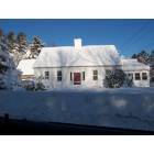
Lamoine, Maine
Lamoine: Lamoine Town Hall
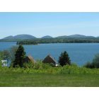
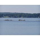
Lamoine: View from Marlboro Beach Road, Lamoine
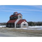
Lamoine: Mud Creek Road Barn, Lamoine, Me
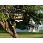
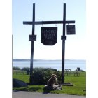
Lamoine: "This is Lamoine"
Lamoine: The view from Lamoine Beach
Lamoine: This is the entrance to Lamoine Park, a small but pretty beach with calm water for saltwater swimming.
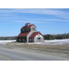
Lamoine: Barn on Mud Creek Road, Lamoine ME
Lamoine: Lamoine Beach Road, Lamoine, Maine
- add
your
Submit your own pictures of this town and show them to the world
- OSM Map
- Google Map
- MSN Map
Population change since 2000: +7.2%
 |
| Males: 781 | |
| Females: 821 |
| Median resident age: | 48.0 years |
| Maine median age: | 43.0 years |
Zip codes: 04605.
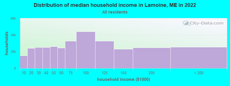
| Lamoine: | $72,613 |
| ME: | $69,543 |
Estimated per capita income in 2022: $40,024 (it was $19,712 in 2000)
Lamoine town income, earnings, and wages data
Estimated median house or condo value in 2022: $301,278 (it was $105,200 in 2000)
| Lamoine: | $301,278 |
| ME: | $290,600 |
Mean prices in 2022: all housing units: $379,336; detached houses: $396,802; townhouses or other attached units: $600,716; in 2-unit structures: $274,479; in 3-to-4-unit structures: $212,346; in 5-or-more-unit structures: $146,369; mobile homes: $158,183; occupied boats, rvs, vans, etc.: $16,454
Detailed information about poverty and poor residents in Lamoine, ME


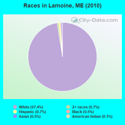
- 1,56097.4%White alone
- 120.7%Two or more races
- 110.7%Hispanic
- 80.5%Black alone
- 80.5%Asian alone
- 20.1%American Indian alone
- 10.06%Other race alone
Races in Lamoine detailed stats: ancestries, foreign born residents, place of birth
According to our research of Maine and other state lists, there were 3 registered sex offenders living in Lamoine, Maine as of June 12, 2024.
The ratio of all residents to sex offenders in Lamoine is 534 to 1.
The ratio of registered sex offenders to all residents in this city is near the state average.
 Recent articles from our blog. Our writers, many of them Ph.D. graduates or candidates, create easy-to-read articles on a wide variety of topics.
Lamoine, ME City Guides:
Ancestries: English (22.7%), Irish (13.2%), United States (11.0%), German (10.0%), Scottish (7.0%), French (6.8%).
Current Local Time: EST time zone
Incorporated on 02/11/1870
Land area: 17.9 square miles.
Population density: 90 people per square mile (very low).
46 residents are foreign born (0.9% Europe, 0.8% North America, 0.6% Latin America, 0.4% Asia, 0.3% Africa).
| This town: | 3.1% |
| Maine: | 2.9% |
| Lamoine town: | 0.8% ($809) |
| Maine: | 1.5% ($1,417) |
Nearest city with pop. 50,000+: Portland, ME  (112.5 miles , pop. 64,249).
Nearest city with pop. 200,000+: Boston, MA (204.7 miles , pop. 589,141).
Nearest city with pop. 1,000,000+: Bronx, NY (378.4 miles , pop. 1,332,650).
Nearest cities:
), )Latitude: 44.49 N, Longitude: 68.32 W
Area code commonly used in this area: 207
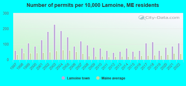
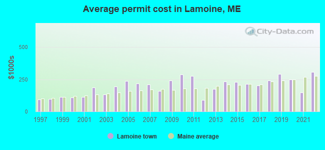
Single-family new house construction building permits:
- 2022: 16 buildings, average cost: $305,000
- 2021: 13 buildings, average cost: $146,200
- 2020: 12 buildings, average cost: $248,700
- 2019: 9 buildings, average cost: $290,100
- 2018: 17 buildings, average cost: $238,500
- 2017: 16 buildings, average cost: $201,400
- 2016: 9 buildings, average cost: $212,100
- 2015: 8 buildings, average cost: $227,200
- 2014: 11 buildings, average cost: $234,300
- 2013: 8 buildings, average cost: $175,400
- 2012: 7 buildings, average cost: $90,600
- 2011: 9 buildings, average cost: $276,900
- 2010: 11 buildings, average cost: $286,700
- 2009: 12 buildings, average cost: $239,700
- 2008: 14 buildings, average cost: $160,400
- 2007: 18 buildings, average cost: $209,400
- 2006: 13 buildings, average cost: $216,300
- 2005: 22 buildings, average cost: $237,200
- 2004: 28 buildings, average cost: $194,500
- 2003: 34 buildings, average cost: $132,700
- 2002: 27 buildings, average cost: $187,800
- 2001: 19 buildings, average cost: $112,200
- 2000: 13 buildings, average cost: $108,800
- 1999: 16 buildings, average cost: $113,100
- 1998: 11 buildings, average cost: $97,500
- 1997: 9 buildings, average cost: $91,700
| Here: | 4.6% |
| Maine: | 3.4% |
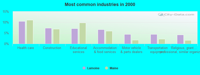
- Health care (10.4%)
- Construction (7.3%)
- Educational services (7.1%)
- Accommodation & food services (6.7%)
- Motor vehicle & parts dealers (4.4%)
- Transportation equipment (4.4%)
- Religious, grantmaking, civic, professional, similar organizations (4.1%)
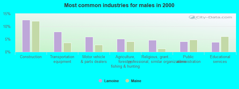
- Construction (12.5%)
- Transportation equipment (7.9%)
- Motor vehicle & parts dealers (5.9%)
- Agriculture, forestry, fishing & hunting (5.1%)
- Religious, grantmaking, civic, professional, similar organizations (4.6%)
- Public administration (4.1%)
- Educational services (3.8%)
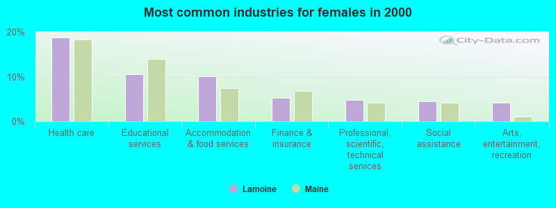
- Health care (18.7%)
- Educational services (10.6%)
- Accommodation & food services (10.1%)
- Finance & insurance (5.3%)
- Professional, scientific, technical services (4.7%)
- Social assistance (4.5%)
- Arts, entertainment, recreation (4.2%)
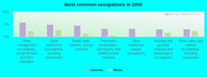
- Other management occupations, except farmers and farm managers (5.7%)
- Other production occupations, including supervisors (4.9%)
- Retail sales workers, except cashiers (4.5%)
- Preschool, kindergarten, elementary, and middle school teachers (3.3%)
- Other healthcare support occupations (3.3%)
- Building and grounds cleaning and maintenance occupations (3.1%)
- Other sales and related occupations, including supervisors (3.1%)
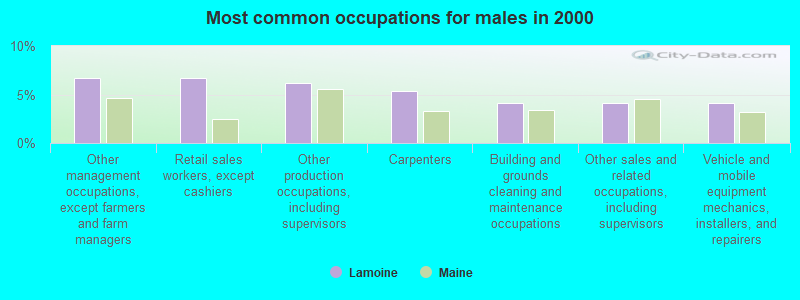
- Other management occupations, except farmers and farm managers (6.6%)
- Retail sales workers, except cashiers (6.6%)
- Other production occupations, including supervisors (6.1%)
- Carpenters (5.4%)
- Building and grounds cleaning and maintenance occupations (4.1%)
- Other sales and related occupations, including supervisors (4.1%)
- Vehicle and mobile equipment mechanics, installers, and repairers (4.1%)

- Preschool, kindergarten, elementary, and middle school teachers (5.6%)
- Secretaries and administrative assistants (5.0%)
- Registered nurses (5.0%)
- Other management occupations, except farmers and farm managers (4.7%)
- Other healthcare support occupations (4.7%)
- Bookkeeping, accounting, and auditing clerks (4.5%)
- Waiters and waitresses (4.2%)
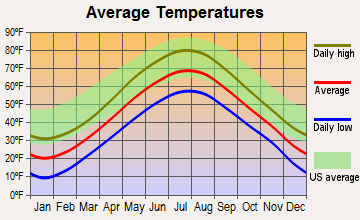
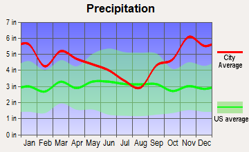
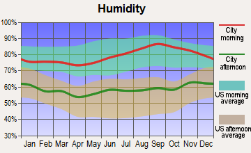
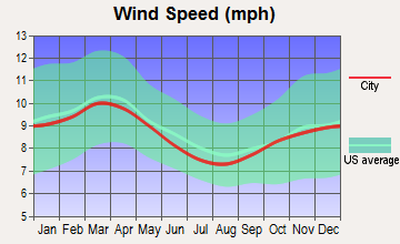
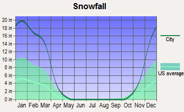
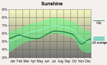
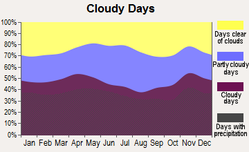
Average climate in Lamoine, Maine
Based on data reported by over 4,000 weather stations
(lower is better)
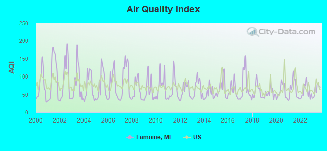
Air Quality Index (AQI) level in 2023 was 61.9. This is about average.
| City: | 61.9 |
| U.S.: | 72.6 |
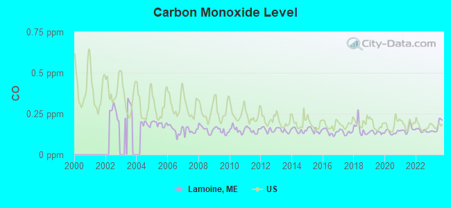
Carbon Monoxide (CO) [ppm] level in 2023 was 0.172. This is significantly better than average. Closest monitor was 8.4 miles away from the city center.
| City: | 0.172 |
| U.S.: | 0.251 |
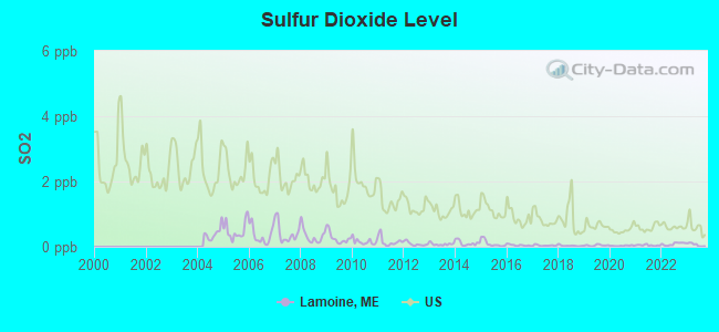
Sulfur Dioxide (SO2) [ppb] level in 2023 was 0.0636. This is significantly better than average. Closest monitor was 8.4 miles away from the city center.
| City: | 0.0636 |
| U.S.: | 1.5147 |
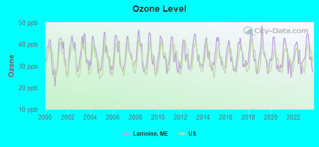
Ozone [ppb] level in 2023 was 36.6. This is about average. Closest monitor was 8.4 miles away from the city center.
| City: | 36.6 |
| U.S.: | 33.3 |
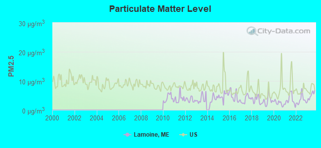
Particulate Matter (PM2.5) [µg/m3] level in 2023 was 4.90. This is significantly better than average. Closest monitor was 8.4 miles away from the city center.
| City: | 4.90 |
| U.S.: | 8.11 |
Earthquake activity:
Lamoine-area historical earthquake activity is significantly above Maine state average. It is 81% smaller than the overall U.S. average.On 10/16/2012 at 23:12:25, a magnitude 4.7 (4.7 ML, Depth: 10.0 mi, Class: Light, Intensity: IV - V) earthquake occurred 131.6 miles away from Lamoine center
On 4/20/2002 at 10:50:47, a magnitude 5.3 (5.3 ML, Depth: 3.0 mi, Class: Moderate, Intensity: VI - VII) earthquake occurred 265.3 miles away from Lamoine center
On 4/20/2002 at 10:50:47, a magnitude 5.2 (5.2 MB, 4.2 MS, 5.2 MW, 5.0 MW) earthquake occurred 266.3 miles away from Lamoine center
On 1/19/1982 at 00:14:42, a magnitude 4.7 (4.5 MB, 4.7 MD, 4.5 LG) earthquake occurred 177.0 miles away from Lamoine center
On 10/7/1983 at 10:18:46, a magnitude 5.3 (5.1 MB, 5.3 LG, 5.1 ML) earthquake occurred 300.8 miles away from the city center
On 10/3/2006 at 00:07:38, a magnitude 3.7 (3.7 MD, Depth: 6.2 mi, Class: Light, Intensity: II - III) earthquake occurred 12.1 miles away from Lamoine center
Magnitude types: regional Lg-wave magnitude (LG), body-wave magnitude (MB), duration magnitude (MD), local magnitude (ML), surface-wave magnitude (MS), moment magnitude (MW)
Natural disasters:
The number of natural disasters in Hancock County (18) is near the US average (15).Major Disasters (Presidential) Declared: 11
Emergencies Declared: 6
Causes of natural disasters: Floods: 9, Storms: 8, Snows: 5, Blizzard: 1, Heavy Rain: 1, Hurricane: 1, Ice Storm: 1, Landslide: 1, Snowfall: 1, Wind: 1, Winter Storm: 1, Other: 2 (Note: some incidents may be assigned to more than one category).
Hospitals and medical centers near Lamoine:
- BIRCHWOOD LIVING CENTER (Hospital, about 6 miles away; ELLSWORTH, ME)
- COLLIER'S REHAB AND NURSING CTR (Nursing Home, about 7 miles away; ELLSWORTH, ME)
- COURTLAND REHAB AND LIVING CENTER (Nursing Home, about 7 miles away; ELLSWORTH, ME)
- SONOGEE ESTATES (Nursing Home, about 8 miles away; BAR HARBOR, ME)
- SONOGEE REHABILITATION AND LIVING CENTER (Nursing Home, about 8 miles away; BAR HARBOR, ME)
- MOUNT DESERT ISLAND HOSPITAL Critical Access Hospitals (about 10 miles away; BAR HARBOR, ME)
Colleges/universities with over 2000 students nearest to Lamoine:
- Husson University (about 33 miles; Bangor, ME; Full-time enrollment: 2,421)
- University of Maine (about 33 miles; Orono, ME; FT enrollment: 8,931)
- University of Maine at Augusta (about 74 miles; Augusta, ME; FT enrollment: 3,204)
- University of Maine at Farmington (about 91 miles; Farmington, ME; FT enrollment: 2,036)
- Southern Maine Community College (about 112 miles; South Portland, ME; FT enrollment: 4,666)
- University of Southern Maine (about 113 miles; Portland, ME; FT enrollment: 6,647)
- Saint Joseph's College of Maine (about 117 miles; Standish, ME; FT enrollment: 2,010)
Public elementary/middle school in Lamoine:
- LAMOINE CONSOLIDATED SCHOOL (Location: 53 LAMOINE BEACH ROAD, Grades: KG-8)
Points of interest:
Notable locations in Lamoine: Lamoine Beach Marina (A), Lamoine Volunteer Fire Department (B). Display/hide their locations on the map
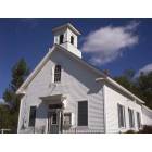
Church in Lamoine: Lamoine Baptist Church (A). Display/hide its location on the map
Cemeteries: Forest Hill Cemetery (1), East Lamoine Cemetery (2). Display/hide their locations on the map
Lake: Blunts Pond (A). Display/hide its location on the map
Streams, rivers, and creeks: Jordan River (A), Spring Brook (B), Mud Creek (C), Martins Brook (D), Archer Brook (E). Display/hide their locations on the map
Park in Lamoine: Lamoine State Park (1). Display/hide its location on the map
Beaches: Marlboro Beach (A), Lamoine Beach (B). Display/hide their locations on the map
Drinking water stations with addresses in Lamoine and their reported violations in the past:
LUNTS LOBSTER POUND (Population served: 225, Groundwater):Past health violations:COLD SPRING WATER COMPANY (Population served: 138, Groundwater):Past monitoring violations:
- MCL, Monthly (TCR) - In JUN-2011, Contaminant: Coliform. Follow-up actions: St Formal NOV issued (JUL-08-2011), St Public Notif requested (JUL-08-2011)
- 8 routine major monitoring violations
- One regular monitoring violation
Past health violations:BLUEBERRY HILL DAIRY BAR (Population served: 87, Groundwater):Past monitoring violations:
- MCL, Monthly (TCR) - In OCT-2007, Contaminant: Coliform. Follow-up actions: St Public Notif requested (NOV-02-2007), St Formal NOV issued (NOV-02-2007), St Public Notif received (NOV-19-2007), St Compliance achieved (AUG-06-2008)
- 3 routine major monitoring violations
- One regular monitoring violation
Past health violations:ELLSWORTH GIANT SUB (Population served: 80, Groundwater):Past monitoring violations:
- MCL, Monthly (TCR) - In SEP-2012, Contaminant: Coliform. Follow-up actions: St Public Notif requested (SEP-24-2012), St Formal NOV issued (SEP-24-2012), St Compliance achieved (OCT-16-2012), St Public Notif received (DEC-20-2012)
- MCL, Monthly (TCR) - In JUL-2009, Contaminant: Coliform. Follow-up actions: St Public Notif requested (JUL-30-2009), St Formal NOV issued (JUL-30-2009), St Compliance achieved (SEP-07-2011), St Intentional no-action (SEP-09-2011)
- MCL, Monthly (TCR) - Between JUL-2007 and SEP-2007, Contaminant: Coliform. Follow-up actions: St Public Notif requested (AUG-03-2007), St Violation/Reminder Notice (AUG-03-2007), St Public Notif received (AUG-14-2007), St Compliance achieved (SEP-07-2011), St Intentional no-action (SEP-09-2011)
- 3 routine major monitoring violations
Past monitoring violations:
- One regular monitoring violation
| This town: | 2.2 people |
| Maine: | 2.3 people |
| This town: | 64.6% |
| Whole state: | 62.9% |
| This town: | 12.1% |
| Whole state: | 9.4% |
Likely homosexual households (counted as self-reported same-sex unmarried-partner households)
- Lesbian couples: 1.4% of all households
- Gay men: 0.3% of all households
| This town: | 8.8% |
| Whole state: | 10.9% |
| This town: | 5.6% |
| Whole state: | 4.1% |
For population 15 years and over in Lamoine:
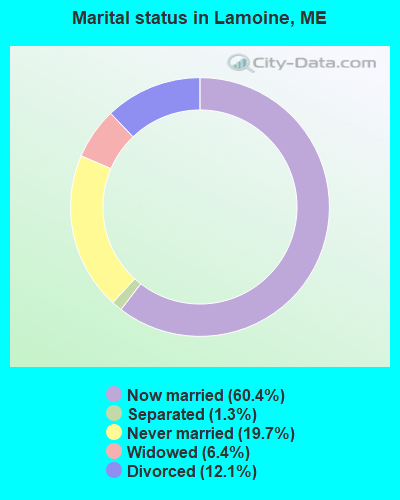
- Never married: 19.7%
- Now married: 60.4%
- Separated: 1.3%
- Widowed: 6.4%
- Divorced: 12.1%
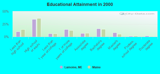
For population 25 years and over in Lamoine:
- High school or higher: 89.9%
- Bachelor's degree or higher: 27.9%
- Graduate or professional degree: 11.7%
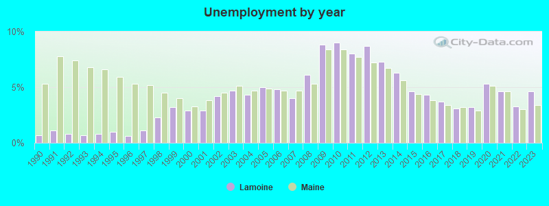
- Unemployed: 3.6%
- Mean travel time to work (commute): 21.5 minutes
| Here: | 10.1 |
| Maine average: | 11.2 |


Graphs represent county-level data. Detailed 2008 Election Results
Religion statistics for Lamoine, ME (based on Hancock County data)


| Religion | Adherents | Congregations |
|---|---|---|
| Mainline Protestant | 4,691 | 58 |
| Catholic | 2,523 | 9 |
| Evangelical Protestant | 1,288 | 23 |
| Other | 820 | 11 |
| None | 45,096 | - |
Food Environment Statistics:
| Hancock County: | 6.01 / 10,000 pop. |
| State: | 2.80 / 10,000 pop. |
| Hancock County: | 1.69 / 10,000 pop. |
| Maine: | 2.20 / 10,000 pop. |
| Hancock County: | 4.89 / 10,000 pop. |
| State: | 5.75 / 10,000 pop. |
| Hancock County: | 21.61 / 10,000 pop. |
| Maine: | 11.02 / 10,000 pop. |
| Here: | 7.4% |
| Maine: | 8.2% |
| Hancock County: | 25.4% |
| Maine: | 25.0% |
Businesses in Lamoine, ME
- Dunkin Donuts: 1
- Home Depot: 1
- Walmart: 1
Strongest AM radio stations in Lamoine:
- WDEA (1370 AM; 5 kW; ELLSWORTH, ME; Owner: CUMULUS LICENSING CORP.)
- WZON (620 AM; 5 kW; BANGOR, ME; Owner: THE ZONE CORPORATION)
- WABI (910 AM; 5 kW; BANGOR, ME; Owner: CLEAR CHANNEL BROADCASTING LICENSES, INC.)
- WSKW (1160 AM; 10 kW; SKOWHEGAN, ME; Owner: MOUNTAIN WIRELESS, INCORPORATED)
- WRKO (680 AM; 50 kW; BOSTON, MA; Owner: ENTERCOM BOSTON LICENSE, LLC)
- WEEI (850 AM; 50 kW; BOSTON, MA; Owner: ENTERCOM BOSTON LICENSE, LLC)
- WBZ (1030 AM; 50 kW; BOSTON, MA; Owner: INFINITY BROADCASTING OPERATIONS, INC.)
- WTME (780 AM; 10 kW; RUMFORD, ME; Owner: MOUNTAIN VALLEY BROADCASTING, INC.)
- WCRN (830 AM; 50 kW; WORCESTER, MA; Owner: CARTER BROADCASTING CORPORATION)
- WNNZ (640 AM; 50 kW; WESTFIELD, MA; Owner: CLEAR CHANNEL BROADCASTING LICENSES, INC.)
- WKOX (1200 AM; 50 kW; FRAMINGHAM, MA; Owner: CAPSTAR TX LIMITED PARTNERSHIP)
- WALE (990 AM; 50 kW; GREENVILLE, RI; Owner: NORTH AMERICAN BROADCASTING CO., INC.)
- WNZS (1340 AM; 1 kW; VEAZIE, ME; Owner: WATERFRONT COMMUNICATIONS INC.)
Strongest FM radio stations in Lamoine:
- WLKE (99.1 FM; BAR HARBOR, ME; Owner: CLEAR CHANNEL BROADCASTING LICENSES, INC.)
- WNSX (97.7 FM; WINTER HARBOR, ME; Owner: CLEAR CHANNEL BROADCASTING LICENSES, INC.)
- WERU-FM (89.9 FM; BLUE HILL, ME; Owner: SALT POND COMMUNITY B/C COMPANY)
- WWMJ (95.7 FM; ELLSWORTH, ME; Owner: CUMULUS LICENSING CORP.)
- WBQI (107.7 FM; BAR HARBOR, ME; Owner: MARINER BROADCASTING, L.P.)
- WMEH (90.9 FM; BANGOR, ME; Owner: MAINE PUBLIC BROADCASTING CORPORATION)
- WEZQ (92.9 FM; BANGOR, ME; Owner: CUMULUS LICENSING CORP.)
- WBFB (104.7 FM; BELFAST, ME; Owner: CLEAR CHANNEL BROADCASTING LICENSES, INC.)
- WKIT-FM (100.3 FM; BREWER, ME; Owner: THE ZONE CORPORATION)
- WFZX (101.7 FM; SEARSPORT, ME; Owner: CLEAR CHANNEL BROADCASTING LICENSES, INC.)
- WHCF (88.5 FM; BANGOR, ME; Owner: BANGOR BAPTIST CHURCH)
- WWBX (97.1 FM; BANGOR, ME; Owner: CLEAR CHANNEL BROADCASTING LICENSES, INC.)
- WVOM (103.9 FM; HOWLAND, ME; Owner: CLEAR CHANNEL BROADCASTING LICENSES, INC.)
- WMEP (90.5 FM; CAMDEN, ME; Owner: MAINE PUBLIC BROADCASTING CORP.)
- WQSS (102.5 FM; CAMDEN, ME; Owner: CLEAR CHANNEL BROADCASTING LICENSES, INC.)
TV broadcast stations around Lamoine:
- WMEB-TV (Channel 12; ORONO, ME; Owner: MAINE PUBLIC BROADCASTING CORPORATION)
- WCKD-LP (Channel 30; BANGOR/DEDHAM, ME; Owner: J. MCLEOD, ME FAMILY B/CING., INC.)
Lamoine fatal accident list:
Jun 9, 2008 01:10 PM, Sr-184, Lat: 44.480530, Lon: -68.269390, Vehicles: 1, Persons: 1, Fatalities: 1
- National Bridge Inventory (NBI) Statistics
- 1Number of bridges
- 10ft / 3.1mTotal length
- 27,700Total average daily traffic
- 2,770Total average daily truck traffic
- 38,780Total future (year 2036) average daily traffic
FCC Registered Antenna Towers:
10 (See the full list of FCC Registered Antenna Towers in Lamoine)FCC Registered Amateur Radio Licenses:
23 (See the full list of FCC Registered Amateur Radio Licenses in Lamoine)FAA Registered Aircraft:
1- Aircraft: CESSNA 172K (Category: Land, Seats: 4, Weight: Up to 12,499 Pounds, Speed: 105 mph), Engine: LYCOMING 0-320 SERIES (180 HP) (4 Cycle)
N-Number: 46643, N46643, N-46643, Serial Number: 17257406, Year manufactured: 1968, Airworthiness Date: 09/04/1968, Certificate Issue Date: 01/16/2003
Registrant (Corporation): Porcupine Islands Flyers, C/O Nathaniel R Fenton / 46 Tamarack Ln, Lamoine, ME 04605
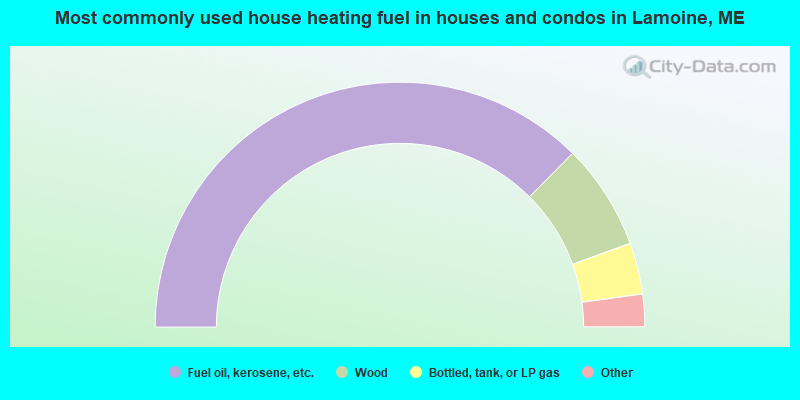
- 75.0%Fuel oil, kerosene, etc.
- 14.0%Wood
- 6.8%Bottled, tank, or LP gas
- 3.5%Electricity
- 0.8%Other fuel
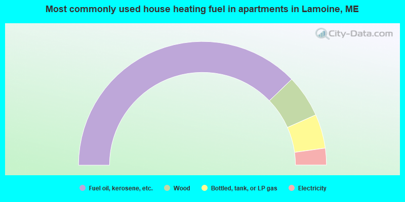
- 75.6%Fuel oil, kerosene, etc.
- 11.1%Wood
- 8.9%Bottled, tank, or LP gas
- 4.4%Electricity
Lamoine compared to Maine state average:
- Unemployed percentage significantly below state average.
- Black race population percentage significantly below state average.
- Hispanic race population percentage below state average.
- Median age above state average.
- Renting percentage below state average.
- Length of stay since moving in significantly above state average.
- Number of rooms per house significantly below state average.
- House age significantly below state average.

|
Total of 5 patent applications in 2008-2024.