Ualapu'e, Hawaii
Submit your own pictures of this place and show them to the world
- OSM Map
- Google Map
- MSN Map
| Males: 206 | |
| Females: 219 |
| Median resident age: | 43.3 years |
| Hawaii median age: | 40.8 years |
| Ualapu'e: | $94,760 |
| HI: | $92,458 |
Estimated per capita income in 2022: $44,225
Ualapu'e CDP income, earnings, and wages data
Estimated median house or condo value in 2022: $922,700
| Ualapu'e: | $922,700 |
| HI: | $820,100 |
Mean prices in 2022: all housing units: $426,967; detached houses: $471,628; in 5-or-more-unit structures: $204,974
Median gross rent in 2022: $1,815.
(6.4% for White Non-Hispanic residents, 17.0% for two or more races residents)
Detailed information about poverty and poor residents in Ualapu'e, HI


- 15933.3%Two or more races
- 13728.7%White alone
- 13127.4%Native Hawaiian and Other
Pacific Islander alone - 306.3%Asian alone
- 245.0%Hispanic

Races in Ualapu'e detailed stats: ancestries, foreign born residents, place of birth
 Recent articles from our blog. Our writers, many of them Ph.D. graduates or candidates, create easy-to-read articles on a wide variety of topics.
Ancestries: German (3.4%), British (1.2%).
Current Local Time: HST (no DST) time zone
14 residents are foreign born (1.5% Asia, 1.0% Europe).
| This place: | 2.9% |
| Hawaii: | 18.0% |
Median real estate property taxes paid for housing units with mortgages in 2022: $573 (0.1%)
Median real estate property taxes paid for housing units with no mortgage in 2022: $774 (0.4%)
Nearest city with pop. 50,000+: Koolaupoko, HI (64.8 miles  , pop. 117,994).
Nearest city with pop. 200,000+: Honolulu, HI (66.0 miles , pop. 371,657).
Nearest city with pop. 1,000,000+: Los Angeles, CA (2505.9 miles , pop. 3,694,820).
Nearest cities:
), ), ), )Latitude: 21.07 N, Longitude: 156.83 W
Area code commonly used in this area: 808


| Here: | 5.3% |
| Hawaii: | 2.9% |
Earthquake activity:
Ualapu'e-area historical earthquake activity is significantly above Hawaii state average. It is 1542% greater than the overall U.S. average.On 11/29/1975 at 14:47:40, a magnitude 7.2 (6.0 MB, 7.1 MS, 7.2 UK, 7.2 MS, Class: Major, Intensity: VIII - XII) earthquake occurred 161.9 miles away from Ualapu'e center, causing 2 deaths (2 shaking deaths)
On 8/21/1951 at 10:57:00, a magnitude 6.9 (6.9 UK, Class: Strong, Intensity: VII - IX) earthquake occurred 106.3 miles away from the city center
On 10/15/2006 at 17:07:49, a magnitude 6.7 (6.2 MB, 6.6 MS, 6.7 MW) earthquake occurred 100.1 miles away from the city center
On 10/15/2006 at 17:07:49, a magnitude 6.7 (6.7 MD, Depth: 23.7 mi) earthquake occurred 101.2 miles away from the city center
On 5/4/2018 at 22:32:54, a magnitude 6.9 (6.9 MW, Depth: 3.6 mi) earthquake occurred 170.0 miles away from Ualapu'e center
On 11/16/1983 at 16:13:00, a magnitude 6.7 (6.4 MB, 6.7 MS, 6.7 MW) earthquake occurred 147.4 miles away from Ualapu'e center, causing $6,000,000 total damage
Magnitude types: body-wave magnitude (MB), duration magnitude (MD), surface-wave magnitude (MS), moment magnitude (MW)
Natural disasters:
The number of natural disasters in Maui County (16) is near the US average (15).Major Disasters (Presidential) Declared: 10
Causes of natural disasters: Floods: 6, Fires: 4, Storms: 4, Heavy Rains: 2, High Surfs: 2, Hurricanes: 2, Landslides: 2, Mudslides: 2, Earthquake: 1, Tropical Storm: 1, Tsunami Wave: 1, Other: 1 (Note: some incidents may be assigned to more than one category).
Colleges/universities with over 2000 students nearest to Ualapu'e:
- University of Hawaii Maui College (about 27 miles; Kahului, HI; Full-time enrollment: 2,492)
- Kapiolani Community College (about 64 miles; Honolulu, HI; FT enrollment: 5,069)
- Chaminade University of Honolulu (about 65 miles; Honolulu, HI; FT enrollment: 2,610)
- University of Hawaii at Manoa (about 66 miles; Honolulu, HI; FT enrollment: 16,461)
- Hawaii Pacific University (about 69 miles; Honolulu, HI; FT enrollment: 5,506)
- Honolulu Community College (about 70 miles; Honolulu, HI; FT enrollment: 2,538)
- Leeward Community College (about 78 miles; Pearl City, HI; FT enrollment: 4,589)
Points of interest:
Notable locations in Ualapu'e: Hōkūkano Heiau (A), Kalauonākukui Heiau (B), Kaluaokapi‘ioho Heiau (C), Pāku‘i Heiau (D). Display/hide their locations on the map
Reservoir: Kaopeahina Fishpond (A). Display/hide its location on the map
| This place: | 2.7 people |
| Hawaii: | 2.9 people |
| This place: | 65.6% |
| Whole state: | 68.9% |
| This place: | 7.6% |
| Whole state: | 7.3% |
No gay or lesbian households reported
For population 15 years and over in Ualapu'e:

- Never married: 26.5%
- Now married: 57.9%
- Separated: 1.1%
- Widowed: 6.7%
- Divorced: 7.8%
For population 25 years and over in Ualapu'e:
- High school or higher: 98.8%
- Bachelor's degree or higher: 32.3%
- Graduate or professional degree: 12.3%
- Mean travel time to work (commute): 21.3 minutes


| Here: | 7.1 |
| Hawaii average: | 11.2 |
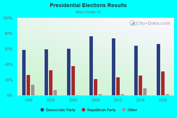
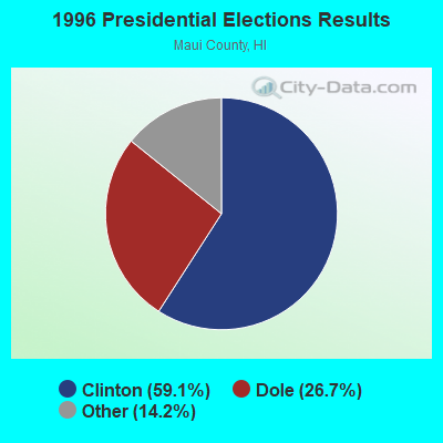
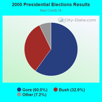
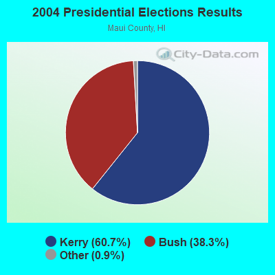
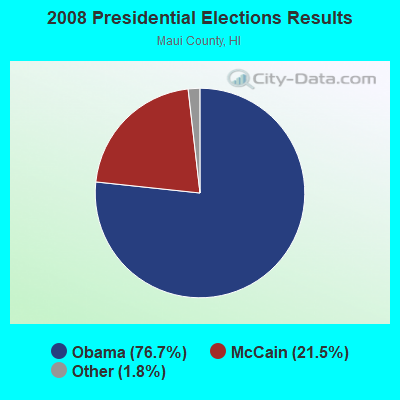
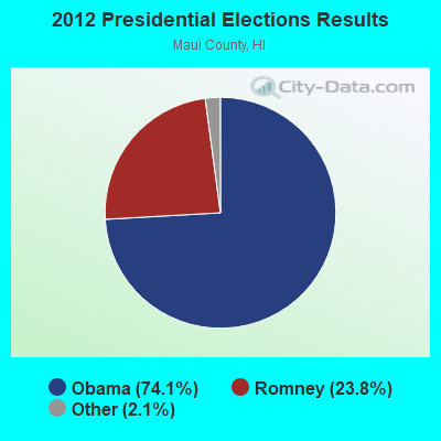
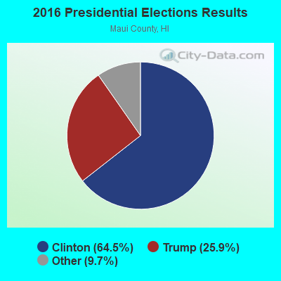
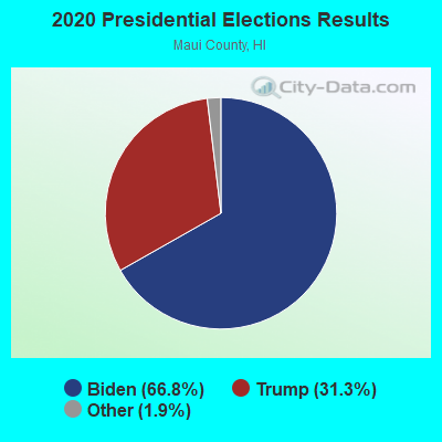
Graphs represent county-level data. Detailed 2008 Election Results
Religion statistics for Ualapu'e, HI (based on Maui County data)
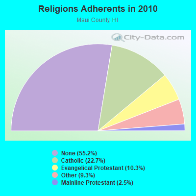
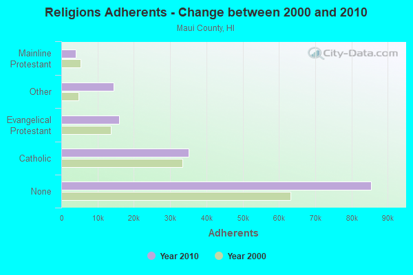
| Religion | Adherents | Congregations |
|---|---|---|
| Catholic | 35,179 | 22 |
| Evangelical Protestant | 15,928 | 76 |
| Other | 14,353 | 53 |
| Mainline Protestant | 3,902 | 37 |
| Orthodox | 15 | 1 |
| None | 85,457 | - |
Food Environment Statistics:
| This county: | 2.90 / 10,000 pop. |
| Hawaii: | 2.30 / 10,000 pop. |
| Here: | 0.07 / 10,000 pop. |
| Hawaii: | 0.09 / 10,000 pop. |
| Here: | 1.84 / 10,000 pop. |
| Hawaii: | 1.57 / 10,000 pop. |
| Maui County: | 2.12 / 10,000 pop. |
| State: | 1.72 / 10,000 pop. |
| Maui County: | 13.44 / 10,000 pop. |
| Hawaii: | 9.00 / 10,000 pop. |
| Maui County: | 7.4% |
| Hawaii: | 8.1% |
| Maui County: | 22.6% |
| Hawaii: | 20.8% |
| Here: | 10.6% |
| Hawaii: | 9.2% |
Strongest AM radio stations in Ualapu'e:
- KAIM (870 AM; 50 kW; HONOLULU, HI; Owner: SALEM MEDIA OF HAWAII, INC.)
- KUAU (1570 AM; 50 kW; HAIKU, HI; Owner: FIRST ASSEMBLY OF GOD-KAHULUI, MAUI)
- KMVI (550 AM; 5 kW; WAILUKU, HI; Owner: PACIFIC RADIO GROUP,INC.)
- KNUI (900 AM; 5 kW; KAHULUI, HI; Owner: PACIFIC RADIO GROUP, INC.)
- KAOI (1110 AM; 5 kW; KIHEI, HI; Owner: VISIONARY RELATED ENTERTAINMENT, INC)
- KORL (690 AM; 10 kW; HONOLULU, HI; Owner: NEW WAVE BROADCASTING, L.P.)
- KGU (760 AM; 10 kW; HONOLULU, HI; Owner: SALEM MEDIA OF HAWAII, INC.)
- KSSK (590 AM; 8 kW; HONOLULU, HI; Owner: CAPSTAR TX LIMITED PARTNERSHIP)
- KHVH (830 AM; 10 kW; HONOLULU, HI; Owner: CAPSTAR TX LIMITED PARTNERSHIP)
- KHNR (650 AM; 10 kW; HONOLULU, HI; Owner: SALEM MEDIA OF HAWAII, INC.)
- KLHT (1040 AM; 10 kW; HONOLULU, HI; Owner: CALVARY CHAPEL OF HONOLULU, INC.)
- KHCM (940 AM; 10 kW; WAIPAHU, HI; Owner: SALEM MEDIA OF HAWAII, INC.)
- KUMU (1500 AM; 10 kW; HONOLULU, HI; Owner: MAVERICK MEDIA OF OAHU LICENSE LLC)
Strongest FM radio stations in Ualapu'e:
- KPOA (93.5 FM; LAHAINA, HI; Owner: PACIFIC RADIO GROUP, INC.)
- KKUA (90.7 FM; WAILUKU, HI; Owner: HAWAII PUBLIC RADIO, INC.)
- KONI (104.7 FM; LANAI CITY, HI; Owner: HOCHMAN HAWAII PUBLISHING, INC.)
- K220HA (91.9 FM; KIHEI, HI; Owner: CALVARY CHAPEL OF TWIN FALLS, INC.)
- K210CM (89.9 FM; KIHEI, HI; Owner: CALVARY CHAPEL OF TWIN FALLS, INC.)
- KLHI-FM (101.1 FM; LAHAINA, HI; Owner: PACIFIC RADIO GROUP, INC.)
- KNUI-FM (99.9 FM; KAHULUI, HI; Owner: PACIFIC RADIO GROUP, INC.)
- KJMD (98.3 FM; PUKALANI, HI; Owner: PACIFIC RADIO GROUP,INC.)
- KXME (104.3 FM; KANEOHE, HI; Owner: CXR HOLDINGS, INC.)
- KRTR-FM (96.3 FM; KAILUA, HI; Owner: CXR HOLDINGS, INC.)
- KAOI-FM (95.1 FM; WAILUKU, HI; Owner: VISIONARY RELATED ENTERTAINMENT INC)
- National Bridge Inventory (NBI) Statistics
- 1Number of bridges
- 3ft / 0.8mTotal length
- $170,000Total costs
- 850Total average daily traffic
- 25Total average daily truck traffic
- 515Total future (year 2025) average daily traffic

- 84.6%No fuel used
- 10.7%Electricity
- 4.7%Solar energy

- 40.0%No fuel used
- 27.3%Bottled, tank, or LP gas
- 18.2%Utility gas
- 14.5%Electricity
Ualapu'e compared to Hawaii state average:
- Median house value significantly below state average.
- Unemployed percentage significantly below state average.
- Black race population percentage significantly below state average.
- Hispanic race population percentage below state average.
- Foreign-born population percentage significantly below state average.
- Length of stay since moving in significantly above state average.
- Number of rooms per house significantly below state average.