Bridge Statistics for Chesapeake, Virginia (VA)
Condition, Traffic, Stress, Structural Evaluation, Project Costs
- National Bridge Inventory (NBI) Statistics
- 299Number of bridges
- 6,457ft / 1,968mTotal length
- $97,440,000Total costs
- 5,554,851Total average daily traffic
- 235,746Total average daily truck traffic
- National Bridge Inventory (NBI) Registered Bridges for Chesapeake
- No street view available for this location
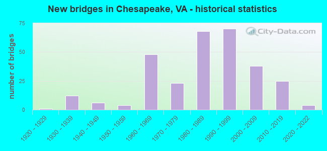
- New bridges - historical statistics
- 11920-1929
- 121930-1939
- 61940-1949
- 41950-1959
- 481960-1969
- 231970-1979
- 681980-1989
- 701990-1999
- 382000-2009
- 252010-2019
- 42020-2022

- Reconstructed bridges - Historical Statistics
- 11940-1949
- 01950-1959
- 11960-1969
- 01970-1979
- 71980-1989
- 11990-1999
- 22000-2009
- 42010-2019
- 12020-2022


- Bridge Condition - Deck
- 3.6%Excellent
- 47.0%Very good
- 40.5%Good
- 7.7%Satisfactory
- 1.2%Fair
- 0.6%Poor

- Bridge Condition - Superstructure
- 0.6%Excellent
- 4.8%Very good
- 48.8%Good
- 29.8%Satisfactory
- 13.7%Fair
- 2.4%Poor

- Bridge Condition - Substructure
- 1.2%Very good
- 45.8%Good
- 34.5%Satisfactory
- 14.3%Fair
- 4.2%Poor

- Bridge Condition - Channel
- 16.8%Excellent
- 47.2%Very good
- 25.6%Good
- 8.8%Satisfactory
- 1.6%Fair
- 0.8%Poor

- Bridge Condition - Culverts
- 6.5%Very good
- 58.7%Good
- 26.1%Satisfactory
- 4.3%Fair
- 4.3%Poor
Find on map >> Show street view
Structure Number: 73, Location: 00.02FR29SBL/00.02TO29NBL (Lat: 38.898292, Lng: -77.070758), Route carried "on" structure: State highway , Year Built: 1983, Status: Open, Structure Length: 3.17m (10.40ft), Average Daily Traffic: 15,315 (year 2020), Truck Traffic: 2%, Average Future Daily Traffic: 16,846 (year 2040), Design Load: HS 20, Features Intersected: I-66_ROSSLYN TUNNEL, Facility Carried by Structure: NORTH LYNN STREET
Minimum Vertical Clearance: 30+ m (98+ ft), Kilometerpoint: 0.000, Lanes on structure: 5, Lanes under structure: 4, Base Highway Network: Yes, Owner: State Highway Agency, Approaching Roadway Width: 24.4m (80.1ft), Material/Design: Steel continuous, Design/Construction: Stringer/Multi-beam, Number Of Spans In Main Unit: 2, Length of Maximum Span: 15.8m (51.8ft), Curb or Sidewalk Widths: Left: 2.7m (8.9ft), Right: 3.0m (9.8ft), Curb-To-Curb Width: 19.2m (63.0ft), Out-to-Out Width: 25.0m (82.0ft)
Condition: Deck: Good, Superstructure: Good, Substructure: Satisfactory, Operating Rating: 62.6 metric tons, Method Used To Determine Operating Rating: Load and Resistance Factor (LRFR), Inventory Rating: 48.1 metric tons, Method Used To Determine Inventory Rating: Load and Resistance Factor (LRFR), Structural Evaluation: Equal to present minimum criteria, Deck Geometry: Meets minimum limits, Underclear: Equal to present minimum criteria, Approach Roadway Alignment: Equal to present desirable criteria, Length Of Structure Improvement: 3.17m (10.40ft), Designated Inspection Frequency: Every 24 months, Inspection Date: May 2021, Bridge Improvement Cost: $99,000, Roadway Improvement Cost: $199,000, Total Project Cost: $310,000 ( Estimate for 2015), Deck Structure Type: Concrete Cast-file-Place, Wearing Surface/Protective System: Wearing Surface: Monolithic Concrete, Deck Protection: Epoxy Coated Reinforcing
Find on map >> Show street view
Structure Number: 88, Location: 00.75 N OF 50 (Lat: 38.874194, Lng: -77.116414), Route carried "on" structure: County highway , Year Built: 1960, Status: Open, Structure Length: 0.64m (2.10ft), Average Daily Traffic: 15,967 (year 2020), Average Future Daily Traffic: 22,354 (year 2040), Design Load: HS 20, Features Intersected: LUBBER RUN, Facility Carried by Structure: GEORGE MASON DRIVE
Minimum Vertical Clearance: 30+ m (98+ ft), Kilometerpoint: 0.000, Lanes on structure: 4, Owner: County Highway Agency, Approaching Roadway Width: 15.2m (49.9ft), Material/Design: Concrete, Design/Construction: Culvert, Number Of Spans In Main Unit: 2, Length of Maximum Span: 3.0m (9.8ft)
Condition: Channel: Satisfactory, Culverts: Satisfactory, Operating Rating: 87.1 metric tons, Method Used To Determine Operating Rating: Load Factor (LF), Inventory Rating: 51.7 metric tons, Method Used To Determine Inventory Rating: Load Factor (LF), Structural Evaluation: Equal to present minimum criteria, Waterway Adequacy: Equal to present desirable criteria, Approach Roadway Alignment: Equal to present desirable criteria, Length Of Structure Improvement: 0.30m (0.98ft), Designated Inspection Frequency: Every 24 months, Inspection Date: March 2020, Bridge Improvement Cost: $1,000, Roadway Improvement Cost: $1,000, Total Project Cost: $3,000 ( Estimate for 2016)
Find on map >> Show street view
Structure Number: 183, Location: 01.90FR7/00.42TO237 (Lat: 38.891619, Lng: -77.166603), Route carried "on" structure: Interstate 66, Year Built: 1981, Status: Open, Structure Length: 6.80m (22.31ft), Average Daily Traffic: 35,481 (year 2020), Truck Traffic: 1%, Average Future Daily Traffic: 49,673 (year 2040), Design Load: HS 20, Features Intersected: 00-06780 WESTMORELAND ST
Minimum Vertical Clearance: 30+ m (98+ ft), Kilometerpoint: 109.702, Lanes on structure: 3, Lanes under structure: 4, Base Highway Network: Yes, Owner: State Highway Agency, Approaching Roadway Width: 18.3m (60.0ft), Skew: 4 degrees, Material/Design: Steel, Design/Construction: Stringer/Multi-beam, Number Of Spans In Main Unit: 3, Number Of Approach Spans: 2, Length of Maximum Span: 28.0m (91.9ft), Curb or Sidewalk Widths: Left: 0.2m (0.7ft), Right: 0.2m (0.7ft), Curb-To-Curb Width: 17.1m (56.1ft), Out-to-Out Width: 18.1m (59.4ft)
Condition: Deck: Good, Superstructure: Satisfactory, Substructure: Satisfactory, Operating Rating: 62.7 metric tons, Method Used To Determine Operating Rating: Load and Resistance Factor (LRFR), Inventory Rating: 48.4 metric tons, Method Used To Determine Inventory Rating: Load and Resistance Factor (LRFR), Structural Evaluation: Equal to present minimum criteria, Deck Geometry: Equal to present minimum criteria, Underclear: Meets minimum limits, Approach Roadway Alignment: Equal to present desirable criteria, Length Of Structure Improvement: 1.52m (4.99ft), Designated Inspection Frequency: Every 24 months, Inspection Date: July 2021, Bridge Improvement Cost: $100,000, Roadway Improvement Cost: $20,000, Total Project Cost: $150,000 ( Estimate for 2015), Deck Structure Type: Concrete Cast-file-Place, Wearing Surface/Protective System: Wearing Surface: Monolithic Concrete, Deck Protection: Epoxy Coated Reinforcing
Find on map >> Show street view
Structure Number: 258, Location: 01.00FR120/00.39TO27 (Lat: 38.859472, Lng: -77.070211), Route carried "on" structure: Interstate 395, Year Built: 1973, Status: Open, Structure Length: 1.98m (6.50ft), Average Daily Traffic: 55,203 (year 2020), Truck Traffic: 3%, Average Future Daily Traffic: 77,284 (year 2040), Design Load: HS 20, Features Intersected: COUNTRY CLUB ROAD, Facility Carried by Structure: SBL-SHIRLEY MEM.HY
Minimum Vertical Clearance: 30+ m (98+ ft), Kilometerpoint: 12.679, Lanes on structure: 4, Lanes under structure: 2, Base Highway Network: Yes, Owner: State Highway Agency, Approaching Roadway Width: 19.2m (63.0ft), Material/Design: Steel, Design/Construction: Stringer/Multi-beam, Number Of Spans In Main Unit: 1, Length of Maximum Span: 19.8m (65.0ft), Curb or Sidewalk Widths: Left: 0.2m (0.7ft), Right: 0.2m (0.7ft), Curb-To-Curb Width: 19.2m (63.0ft), Out-to-Out Width: 20.2m (66.3ft)
Condition: Deck: Satisfactory, Superstructure: Satisfactory, Substructure: Satisfactory, Operating Rating: 66.0 metric tons, Method Used To Determine Operating Rating: Load and Resistance Factor (LRFR), Inventory Rating: 50.9 metric tons, Method Used To Determine Inventory Rating: Load and Resistance Factor (LRFR), Structural Evaluation: Equal to present minimum criteria, Deck Geometry: Somewhat better than minimum adequacy, Underclear: Equal to present minimum criteria, Approach Roadway Alignment: Equal to present desirable criteria, Length Of Structure Improvement: 1.98m (6.50ft), Designated Inspection Frequency: Every 24 months, Inspection Date: September 2020, Bridge Improvement Cost: $183,000, Roadway Improvement Cost: $60,000, Total Project Cost: $253,000 ( Estimate for 2014), Deck Structure Type: Concrete Cast-file-Place, Wearing Surface/Protective System: Wearing Surface: Monolithic Concrete
Find on map >> Show street view
Structure Number: 374, Location: 0.02 fr 690/1.28 to 701 (Lat: 37.883386, Lng: -75.618219), Route carried "on" structure: County highway 692, Year Built: 1968, Status: Open, Structure Length: 1.34m (4.40ft), Average Daily Traffic: 216 (year 2020), Truck Traffic: 2%, Average Future Daily Traffic: 238 (year 2040), Design Load: HS 20+Mod, Features Intersected: Messongo Creek, Facility Carried by Structure: Savannah Road
Minimum Vertical Clearance: 30+ m (98+ ft), Kilometerpoint: 7.015, Lanes on structure: 2, Owner: State Highway Agency, Approaching Roadway Width: 5.5m (18.0ft), Material/Design: Concrete, Design/Construction: Slab, Number Of Spans In Main Unit: 2, Length of Maximum Span: 6.7m (22.0ft), Curb-To-Curb Width: 8.5m (27.9ft), Out-to-Out Width: 9.1m (29.9ft)
Condition: Deck: Good, Superstructure: Good, Substructure: Satisfactory, Channel: Good, Operating Rating: 56.3 metric tons, Method Used To Determine Operating Rating: Load and Resistance Factor (LRFR), Inventory Rating: 43.5 metric tons, Method Used To Determine Inventory Rating: Load and Resistance Factor (LRFR), Structural Evaluation: Equal to present minimum criteria, Deck Geometry: Equal to present minimum criteria, Waterway Adequacy: Better than present minimum criteria, Approach Roadway Alignment: Equal to present desirable criteria, Length Of Structure Improvement: 1.31m (4.30ft), Designated Inspection Frequency: Every 24 months, Inspection Date: April 2020, Bridge Improvement Cost: $99,000, Roadway Improvement Cost: $20,000, Total Project Cost: $120,000, Deck Structure Type: Concrete Cast-file-Place, Wearing Surface/Protective System: Wearing Surface: Epoxy Overlay, Membrane: Epoxy
Find on map >> Show street view
Structure Number: 375, Location: 0.15 TO 690 / 1.30 TO 779 (Lat: 37.882481, Lng: -75.615550), Route carried "on" structure: County highway 692, Year Built: 1987, Status: Open, Structure Length: 1.83m (6.00ft), Average Daily Traffic: 200 (year 2020), Truck Traffic: 2%, Average Future Daily Traffic: 220 (year 2040), Design Load: HS 20, Features Intersected: Messongo Creek, Facility Carried by Structure: Savanna Road
Minimum Vertical Clearance: 30+ m (98+ ft), Kilometerpoint: 7.289, Lanes on structure: 2, Owner: State Highway Agency, Approaching Roadway Width: 6.4m (21.0ft), Skew: 6 degrees, Material/Design: Steel, Design/Construction: Culvert, Number Of Spans In Main Unit: 4, Length of Maximum Span: 3.7m (12.1ft)
Condition: Channel: Fair, Culverts: Good, Operating Rating: 44.5 metric tons, Method Used To Determine Operating Rating: Load Factor (LF), Inventory Rating: 32.7 metric tons, Method Used To Determine Inventory Rating: Load Factor (LF), Structural Evaluation: Better than present minimum criteria, Waterway Adequacy: Equal to present desirable criteria, Approach Roadway Alignment: Equal to present desirable criteria, Designated Inspection Frequency: Every 24 months, Inspection Date: December 2020
Find on map >> Show street view
Structure Number: 441, Location: 0.18 FR 713 / 0.63 TO 714 (Lat: 37.841092, Lng: -78.548508), Route carried "on" structure: State highway 20, Year Built: 1974, Status: Open, Structure Length: 0.88m (2.89ft), Average Daily Traffic: 6,385 (year 2020), Truck Traffic: 3%, Average Future Daily Traffic: 8,146 (year 2040), Design Load: HS 20, Features Intersected: BRANCH OF TOTIER CREEK, Facility Carried by Structure: SCOTTSVILLE ROAD
Minimum Vertical Clearance: 30+ m (98+ ft), Kilometerpoint: 38.077, Lanes on structure: 2, Base Highway Network: Yes, Owner: State Highway Agency, Approaching Roadway Width: 7.3m (24.0ft), Skew: 4 degrees, Material/Design: Steel, Design/Construction: Culvert, Number Of Spans In Main Unit: 2, Length of Maximum Span: 4.0m (13.1ft)
Condition: Channel: Fair, Culverts: Satisfactory, Operating Rating: 44.5 metric tons, Method Used To Determine Operating Rating: Field evaluation and documented engineering judgment, Inventory Rating: 32.7 metric tons, Method Used To Determine Inventory Rating: Field evaluation and documented engineering judgment, Structural Evaluation: Equal to present minimum criteria, Waterway Adequacy: Equal to present minimum criteria, Approach Roadway Alignment: Equal to present desirable criteria, Designated Inspection Frequency: Every 24 months, Inspection Date: April 2021
Find on map >> Show street view
Structure Number: 677, Location: 1.07 FR 708 / 2.84 TO 706 (Lat: 37.946908, Lng: -78.570481), Route carried "on" structure: County highway 631, Year Built: 1932, Year Reconstructed: 2000, Status: Open, Structure Length: 1.34m (4.40ft), Average Daily Traffic: 1,249 (year 2020), Truck Traffic: 3%, Average Future Daily Traffic: 1,582 (year 2040), Design Load: H 20, Features Intersected: NORTH FORK HARDWARE RVR, Facility Carried by Structure: OLD LYNCHBURG ROAD
Minimum Vertical Clearance: 30+ m (98+ ft), Kilometerpoint: 8.515, Lanes on structure: 2, Owner: State Highway Agency, Approaching Roadway Width: 5.5m (18.0ft), Material/Design: Prestressed concrete, Design/Construction: Slab, Number Of Spans In Main Unit: 1, Length of Maximum Span: 12.8m (42.0ft), Curb-To-Curb Width: 7.2m (23.6ft), Out-to-Out Width: 7.3m (24.0ft)
Condition: Deck: Good, Superstructure: Good, Substructure: Satisfactory, Channel: Satisfactory, Operating Rating: 82.6 metric tons, Method Used To Determine Operating Rating: Load and Resistance Factor (LRFR), Inventory Rating: 63.5 metric tons, Method Used To Determine Inventory Rating: Load and Resistance Factor (LRFR), Structural Evaluation: Equal to present minimum criteria, Deck Geometry: High priority of corrective action, Waterway Adequacy: Equal to present minimum criteria, Approach Roadway Alignment: Equal to present minimum criteria, Length Of Structure Improvement: 1.52m (4.99ft), Designated Inspection Frequency: Every 24 months, Inspection Date: July 2020, Bridge Improvement Cost: $250,000, Roadway Improvement Cost: $75,000, Total Project Cost: $350,000, Deck Structure Type: Other, Wearing Surface/Protective System: Wearing Surface: Bituminous
Find on map >> Show street view
Structure Number: 746, Location: 0.02 FR 240 / 0.51 TO 802 (Lat: 38.062578, Lng: -78.648119), Route carried "on" structure: County highway 680, Year Built: 1932, Year Reconstructed: 1989, Status: Open, Structure Length: 0.88m (2.89ft), Average Daily Traffic: 571 (year 2015), Average Future Daily Traffic: 642 (year 2040), Features Intersected: LICKINGHOLE CREEK, Facility Carried by Structure: BROWNS GAP TURNPIK
Minimum Vertical Clearance: 30+ m (98+ ft), Kilometerpoint: 0.040, Lanes on structure: 1, Owner: State Highway Agency, Approaching Roadway Width: 4.6m (15.1ft), Skew: 2 degrees, Material/Design: Steel, Design/Construction: Stringer/Multi-beam, Number Of Spans In Main Unit: 1, Length of Maximum Span: 8.8m (28.9ft), Curb-To-Curb Width: 4.0m (13.1ft), Out-to-Out Width: 4.7m (15.4ft)
Condition: Deck: Satisfactory, Superstructure: Satisfactory, Substructure: Poor, Channel: Fair, Operating Rating: 49.9 metric tons, Method Used To Determine Operating Rating: Allowable Stress (AS), Inventory Rating: 34.5 metric tons, Method Used To Determine Inventory Rating: Allowable Stress (AS), Structural Evaluation: Meets minimum limits, Deck Geometry: High priority of replacement, Waterway Adequacy: Equal to present minimum criteria, Approach Roadway Alignment: Equal to present minimum criteria, Length Of Structure Improvement: 1.52m (4.99ft), Designated Inspection Frequency: Every 12 months, Inspection Date: November 2021, Bridge Improvement Cost: $125,000, Roadway Improvement Cost: $20,000, Total Project Cost: $160,000, Deck Structure Type: Wood or Timber
Find on map >> Show street view
Structure Number: 848, Location: 0.60 FR 231 / 0.10 TO 22 (Lat: 38.056736, Lng: -78.300175), Route carried "on" structure: County highway 783, Year Built: 1932, Year Reconstructed: 2012, Status: Open, Structure Length: 0.79m (2.59ft), Average Daily Traffic: 14 (year 2018), Average Future Daily Traffic: 16 (year 2040), Design Load: HS 20+Mod, Features Intersected: BRANCH MECHUNK CREEK, Facility Carried by Structure: MILLWOOD LANE
Minimum Vertical Clearance: 30+ m (98+ ft), Kilometerpoint: 0.965, Lanes on structure: 1, Owner: State Highway Agency, Approaching Roadway Width: 6.0m (19.7ft), Skew: 2 degrees, Material/Design: Concrete, Design/Construction: Slab, Number Of Spans In Main Unit: 1, Length of Maximum Span: 7.9m (25.9ft), Curb-To-Curb Width: 4.1m (13.5ft), Out-to-Out Width: 4.3m (14.1ft)
Condition: Deck: Good, Superstructure: Good, Substructure: Good, Channel: Good, Operating Rating: 51.7 metric tons, Method Used To Determine Operating Rating: Load and Resistance Factor (LRFR), Inventory Rating: 39.0 metric tons, Method Used To Determine Inventory Rating: Load and Resistance Factor (LRFR), Structural Evaluation: Better than present minimum criteria, Deck Geometry: Somewhat better than minimum adequacy, Waterway Adequacy: Equal to present minimum criteria, Approach Roadway Alignment: Equal to present minimum criteria, Length Of Structure Improvement: 0.91m (2.99ft), Designated Inspection Frequency: Every 24 months, Inspection Date: Febuary 2022, Bridge Improvement Cost: $85,000, Roadway Improvement Cost: $15,000, Total Project Cost: $115,000, Deck Structure Type: Concrete Precast Panels, Wearing Surface/Protective System: Wearing Surface: Bituminous, Membrane: Epoxy, Deck Protection: Other
Find on map >> Show street view
Structure Number: 936, Location: 0.23 TO 627 & 0.17 TO 671 (Lat: 37.819239, Lng: -79.800183), Route carried "on" structure: US 60, Year Built: 1985, Status: Open, Structure Length: 4.02m (13.19ft), Average Daily Traffic: 3,604 (year 2020), Truck Traffic: 2%, Average Future Daily Traffic: 3,964 (year 2040), Design Load: HS 20+Mod, Features Intersected: RTE 220
Minimum Vertical Clearance: 30+ m (98+ ft), Kilometerpoint: 22.365, Lanes on structure: 2, Lanes under structure: 2, Owner: State Highway Agency, Approaching Roadway Width: 11.0m (36.1ft), Skew: 3 degrees, Material/Design: Steel, Design/Construction: Stringer/Multi-beam, Number Of Spans In Main Unit: 1, Length of Maximum Span: 38.7m (127.0ft), Curb-To-Curb Width: 19.1m (62.7ft), Out-to-Out Width: 20.1m (65.9ft)
Condition: Deck: Good, Superstructure: Good, Substructure: Satisfactory, Operating Rating: 89.8 metric tons, Method Used To Determine Operating Rating: Load and Resistance Factor (LRFR), Inventory Rating: 70.8 metric tons, Method Used To Determine Inventory Rating: Load and Resistance Factor (LRFR), Structural Evaluation: Equal to present minimum criteria, Deck Geometry: Superior to present desirable criteria, Underclear: High priority of corrective action, Approach Roadway Alignment: Equal to present desirable criteria, Designated Inspection Frequency: Every 24 months, Inspection Date: October 2020, Deck Structure Type: Concrete Cast-file-Place, Wearing Surface/Protective System: Deck Protection: Epoxy Coated Reinforcing
Find on map >> Show street view
Structure Number: 975, Location: 1.89 TO 661 & 1.03 TO 159 (Lat: 37.815231, Lng: -80.078583), Route carried "on" structure: Interstate 64, Year Built: 1966, Status: Open, Structure Length: 0.63m (2.07ft), Average Daily Traffic: 7,653 (year 2020), Truck Traffic: 24%, Average Future Daily Traffic: 8,873 (year 2040), Design Load: HS 20, Features Intersected: THORNY BRANCH
Minimum Vertical Clearance: 30+ m (98+ ft), Kilometerpoint: 14.561, Lanes on structure: 4, Base Highway Network: Yes, Owner: State Highway Agency, Approaching Roadway Width: 32.9m (107.9ft), Skew: 3 degrees, Material/Design: Concrete, Design/Construction: Culvert, Number Of Spans In Main Unit: 2, Length of Maximum Span: 2.4m (7.9ft)
Condition: Channel: Satisfactory, Culverts: Satisfactory, Operating Rating: 89.8 metric tons, Method Used To Determine Operating Rating: Field evaluation and documented engineering judgment, Inventory Rating: 88.9 metric tons, Method Used To Determine Inventory Rating: Field evaluation and documented engineering judgment, Structural Evaluation: Equal to present minimum criteria, Waterway Adequacy: Equal to present desirable criteria, Approach Roadway Alignment: Equal to present desirable criteria, Designated Inspection Frequency: Every 24 months, Inspection Date: Febuary 2021
Find on map >> Show street view
Structure Number: 1123, Location: 0.07 TO 622 & 2.93 TO 623 (Lat: 37.740031, Lng: -79.911994), Route carried "on" structure: County highway 616, Year Built: 1966, Status: Open, Structure Length: 0.78m (2.56ft), Average Daily Traffic: 631 (year 2020), Truck Traffic: 7%, Average Future Daily Traffic: 726 (year 2040), Design Load: HS 20, Features Intersected: KARNES CREEK, Facility Carried by Structure: RICH PATCH ROAD
Minimum Vertical Clearance: 30+ m (98+ ft), Kilometerpoint: 24.338, Lanes on structure: 2, Owner: State Highway Agency, Approaching Roadway Width: 5.5m (18.0ft), Material/Design: Concrete, Design/Construction: Culvert, Number Of Spans In Main Unit: 4, Length of Maximum Span: 1.8m (5.9ft)
Condition: Channel: Fair, Culverts: Good, Operating Rating: 30.5 metric tons, Method Used To Determine Operating Rating: Load and Resistance Factor (LRFR), Inventory Rating: 23.5 metric tons, Method Used To Determine Inventory Rating: Load and Resistance Factor (LRFR), Structural Evaluation: Equal to present minimum criteria, Waterway Adequacy: Better than present minimum criteria, Approach Roadway Alignment: Better than present minimum criteria, Length Of Structure Improvement: 0.79m (2.59ft), Designated Inspection Frequency: Every 24 months, Inspection Date: May 2020, Bridge Improvement Cost: $125,000, Roadway Improvement Cost: $50,000, Total Project Cost: $175,000
Find on map >> Show street view
Structure Number: 1763, Location: 6.08 RCKBR CO- 1.58 RT 11 (Lat: 38.009939, Lng: -79.163719), Route carried "on" structure: Interstate 81, Year Built: 1966, Status: Open, Structure Length: 3.77m (12.37ft), Average Daily Traffic: 21,677 (year 2020), Truck Traffic: 29%, Average Future Daily Traffic: 30,348 (year 2040), Design Load: HS 20+Mod, Features Intersected: STOVER SCHOOL RD (662)
Minimum Vertical Clearance: 5.26m (17.26ft), Kilometerpoint: 341.301, Lanes on structure: 2, Lanes under structure: 2, Base Highway Network: Yes, Owner: State Highway Agency, Approaching Roadway Width: 12.8m (42.0ft), Skew: 2 degrees, Material/Design: Concrete, Design/Construction: Tee Beam, Number Of Spans In Main Unit: 3, Length of Maximum Span: 14.8m (48.6ft), Curb-To-Curb Width: 12.2m (40.0ft), Out-to-Out Width: 12.8m (42.0ft)
Condition: Deck: Satisfactory, Superstructure: Satisfactory, Substructure: Satisfactory, Operating Rating: 55.3 metric tons, Method Used To Determine Operating Rating: Load and Resistance Factor (LRFR), Inventory Rating: 42.6 metric tons, Method Used To Determine Inventory Rating: Load and Resistance Factor (LRFR), Structural Evaluation: Equal to present minimum criteria, Deck Geometry: Better than present minimum criteria, Underclear: Meets minimum limits, Approach Roadway Alignment: Equal to present desirable criteria, Designated Inspection Frequency: Every 24 months, Inspection Date: June 2021, Bridge Improvement Cost: $42,000, Total Project Cost: $44,000, Deck Structure Type: Concrete Cast-file-Place, Wearing Surface/Protective System: Wearing Surface: Latex Concrete
Find on map >> Show street view
Structure Number: 1818, Location: DEEP CREEK (Lat: 36.741072, Lng: -76.344878), Route carried "on" structure: Business US 17, Year Built: 1934, Status: Posted for load, Structure Length: 3.95m (12.96ft), Average Daily Traffic: 33,000 (year 2018), Truck Traffic: 5%, Average Future Daily Traffic: 51,000 (year 2040), Design Load: H 15, Features Intersected: DISMAL SWAMP CANAL
Minimum Vertical Clearance: 30+ m (98+ ft), Kilometerpoint: 32.731, Lanes on structure: 2, Owner: Corps of Engineers (Civil), Approaching Roadway Width: 6.0m (19.7ft), Navigation Control: Yes ( Vertical Clearance: 1.1m (3.6ft), Horizontal Clearance: 15.2m (49.9ft)), Material/Design: Steel, Design/Construction: Movable - Bascule, Number Of Spans In Main Unit: 1, Number Of Approach Spans: 2, Length of Maximum Span: 19.5m (64.0ft), Curb or Sidewalk Widths: Left: 0.3m (1.0ft), Right: 1.1m (3.6ft), Curb-To-Curb Width: 6.0m (19.7ft), Out-to-Out Width: 6.4m (21.0ft)
Condition: Deck: Fair, Superstructure: Fair, Substructure: Good, Channel: Excellent, Operating Rating: 36.5 metric tons, Method Used To Determine Operating Rating: Allowable Stress (AS), Inventory Rating: 25.1 metric tons, Method Used To Determine Inventory Rating: Allowable Stress (AS), Structural Evaluation: Somewhat better than minimum adequacy, Deck Geometry: High priority of replacement, Waterway Adequacy: Superior to present desirable criteria, Approach Roadway Alignment: Equal to present minimum criteria, Bridge Posting: Required (Relationship of Operating Rating to Maximum Legal Load: 20.0 - 29.9% below), Length Of Structure Improvement: 3.95m (12.96ft), Designated Inspection Frequency: Every 24 months, Critical Feature Inspection Frequency: Every 24 months, Underwater Inspection Frequency: Every 24 months, Inspection Date: September 2020, Critical Feature Inspection Date: September 2020, Underwater Inspection Date: January 2021, Bridge Improvement Cost: $21,722,000, Roadway Improvement Cost: $8,838,000, Total Project Cost: $47,998,000 ( Estimate for 2018), Deck Structure Type: Open Grating
Find on map >> Show street view
Structure Number: 3078, Location: 0.25 FR 631 - 2.65 TO 611 (Lat: 37.177392, Lng: -80.982131), Route carried "on" structure: County highway 612, Year Built: 1932, Year Reconstructed: 2019, Status: Open, Structure Length: 1.51m (4.95ft), Average Daily Traffic: 143 (year 2015), Average Future Daily Traffic: 164 (year 2040), Design Load: HL 93, Features Intersected: KIMBERLING CREEK, Facility Carried by Structure: KIMBERLING ROAD
Minimum Vertical Clearance: 30+ m (98+ ft), Kilometerpoint: 17.874, Lanes on structure: 1, Owner: State Highway Agency, Approaching Roadway Width: 6.1m (20.0ft), Skew: 2 degrees, Material/Design: Concrete, Design/Construction: Slab, Number Of Spans In Main Unit: 2, Length of Maximum Span: 6.9m (22.6ft), Curb-To-Curb Width: 4.1m (13.5ft), Out-to-Out Width: 4.2m (13.8ft)
Condition: Deck: Good, Superstructure: Good, Substructure: Satisfactory, Channel: Satisfactory, Operating Rating: 69.9 metric tons, Method Used To Determine Operating Rating: Load and Resistance Factor (LRFR), Inventory Rating: 53.5 metric tons, Method Used To Determine Inventory Rating: Load and Resistance Factor (LRFR), Structural Evaluation: Equal to present minimum criteria, Deck Geometry: High priority of replacement, Waterway Adequacy: Better than present minimum criteria, Approach Roadway Alignment: Better than present minimum criteria, Designated Inspection Frequency: Every 24 months, Inspection Date: June 2021, Deck Structure Type: Concrete Precast Panels, Wearing Surface/Protective System: Wearing Surface: Bituminous, Membrane: Epoxy
Find on map >> Show street view
Structure Number: 3743, Location: .5 FR 690 & 1.3 TO 602 (Lat: 36.592556, Lng: -77.766986), Route carried "on" structure: County highway 672, Year Built: 1950, Year Reconstructed: 1974, Status: Posted for load, Structure Length: 1.26m (4.13ft), Average Daily Traffic: 80 (year 2016), Average Future Daily Traffic: 90 (year 2040), Features Intersected: RATTLESNAKE CREEK, Facility Carried by Structure: TRIPLET ROAD
Minimum Vertical Clearance: 30+ m (98+ ft), Kilometerpoint: 1.598, Lanes on structure: 2, Owner: State Highway Agency, Approaching Roadway Width: 6.1m (20.0ft), Material/Design: Steel, Design/Construction: Stringer/Multi-beam, Number Of Spans In Main Unit: 1, Length of Maximum Span: 12.2m (40.0ft), Curb or Sidewalk Widths: Left: 0.2m (0.7ft), Right: 0.2m (0.7ft), Curb-To-Curb Width: 5.9m (19.4ft), Out-to-Out Width: 6.2m (20.3ft)
Condition: Deck: Good, Superstructure: Satisfactory, Substructure: Fair, Channel: Poor, Operating Rating: 11.8 metric tons, Method Used To Determine Operating Rating: Field evaluation and documented engineering judgment, Inventory Rating: 6.4 metric tons, Method Used To Determine Inventory Rating: Field evaluation and documented engineering judgment, Structural Evaluation: High priority of corrective action, Deck Geometry: Meets minimum limits, Waterway Adequacy: Meets minimum limits, Approach Roadway Alignment: Equal to present minimum criteria, Bridge Posting: Required (Relationship of Operating Rating to Maximum Legal Load: > 39.9% below), Length Of Structure Improvement: 1.28m (4.20ft), Designated Inspection Frequency: Every 12 months, Underwater Inspection Frequency: Every 60 months, Inspection Date: November 2021, Underwater Inspection Date: May 2021, Bridge Improvement Cost: $100,000, Roadway Improvement Cost: $30,000, Total Project Cost: $210,000 ( Estimate for 2015), Deck Structure Type: Wood or Timber, Wearing Surface/Protective System: Wearing Surface: Bituminous
Find on map >> Show street view
Structure Number: 4412, Location: 0.6M RTE619-1.0M RTE608 (Lat: 38.058881, Lng: -77.341861), Route carried "on" structure: Business US 301, Year Built: 1965, Status: Open, Structure Length: 0.70m (2.30ft), Average Daily Traffic: 3,681 (year 2020), Truck Traffic: 7%, Average Future Daily Traffic: 5,155 (year 2040), Design Load: H 15, Features Intersected: MARACOSSIC CREEK, Facility Carried by Structure: SBL A.P HILL BLVD.
Minimum Vertical Clearance: 30+ m (98+ ft), Kilometerpoint: 2.407, Lanes on structure: 4, Owner: State Highway Agency, Approaching Roadway Width: 7.3m (24.0ft), Skew: 2 degrees, Material/Design: Concrete, Design/Construction: Culvert, Number Of Spans In Main Unit: 2, Length of Maximum Span: 3.0m (9.8ft)
Condition: Channel: Satisfactory, Culverts: Satisfactory, Operating Rating: 89.8 metric tons, Method Used To Determine Operating Rating: Field evaluation and documented engineering judgment, Inventory Rating: 89.8 metric tons, Method Used To Determine Inventory Rating: Field evaluation and documented engineering judgment, Structural Evaluation: Equal to present minimum criteria, Waterway Adequacy: Equal to present minimum criteria, Approach Roadway Alignment: Equal to present desirable criteria, Designated Inspection Frequency: Every 24 months, Inspection Date: January 2021
Find on map >> Show street view
Structure Number: 4649, Location: 1.90 RT 736; 0.05 RT 733 (Lat: 36.768806, Lng: -80.907906), Route carried "on" structure: County highway 635, Year Built: 1967, Status: Open, Structure Length: 3.30m (10.83ft), Average Daily Traffic: 193 (year 2020), Truck Traffic: 1%, Average Future Daily Traffic: 212 (year 2040), Design Load: HS 20+Mod, Features Intersected: CROOKED CREEK
Minimum Vertical Clearance: 30+ m (98+ ft), Kilometerpoint: 10.780, Lanes on structure: 2, Owner: State Highway Agency, Approaching Roadway Width: 6.1m (20.0ft), Material/Design: Concrete continuous, Design/Construction: Frame, Number Of Spans In Main Unit: 3, Length of Maximum Span: 11.3m (37.1ft), Curb or Sidewalk Widths: Left: 0.0m, Right: 0.2m (0.7ft), Curb-To-Curb Width: 9.0m (29.5ft), Out-to-Out Width: 11.1m (36.4ft)
Condition: Deck: Satisfactory, Superstructure: Satisfactory, Substructure: Good, Channel: Satisfactory, Operating Rating: 52.6 metric tons, Method Used To Determine Operating Rating: Load and Resistance Factor (LRFR), Inventory Rating: 39.9 metric tons, Method Used To Determine Inventory Rating: Load and Resistance Factor (LRFR), Structural Evaluation: Equal to present minimum criteria, Deck Geometry: Equal to present minimum criteria, Waterway Adequacy: Equal to present minimum criteria, Approach Roadway Alignment: Equal to present minimum criteria, Designated Inspection Frequency: Every 24 months, Inspection Date: January 2021, Deck Structure Type: Concrete Cast-file-Place
Find on map >> Show street view
Structure Number: 4662, Location: 0.75-Rte644; 0.70-Rte643 (Lat: 36.672475, Lng: -80.523794), Route carried "on" structure: County highway 640, Year Built: 1967, Status: Open, Structure Length: 0.76m (2.49ft), Average Daily Traffic: 50 (year 2019), Average Future Daily Traffic: 55 (year 2040), Features Intersected: Br Big Reed Island Creek
Minimum Vertical Clearance: 30+ m (98+ ft), Kilometerpoint: 9.567, Lanes on structure: 2, Owner: State Highway Agency, Approaching Roadway Width: 3.7m (12.1ft), Material/Design: Steel, Design/Construction: Stringer/Multi-beam, Number Of Spans In Main Unit: 1, Length of Maximum Span: 7.6m (24.9ft), Curb or Sidewalk Widths: Left: 0.2m (0.7ft), Right: 0.2m (0.7ft), Curb-To-Curb Width: 6.1m (20.0ft), Out-to-Out Width: 6.4m (21.0ft)
Condition: Deck: Good, Superstructure: Very good, Substructure: Good, Channel: Satisfactory, Operating Rating: 68.9 metric tons, Method Used To Determine Operating Rating: Load and Resistance Factor (LRFR), Inventory Rating: 52.6 metric tons, Method Used To Determine Inventory Rating: Load and Resistance Factor (LRFR), Structural Evaluation: Better than present minimum criteria, Deck Geometry: Somewhat better than minimum adequacy, Waterway Adequacy: Somewhat better than minimum adequacy, Approach Roadway Alignment: Equal to present desirable criteria, Designated Inspection Frequency: Every 24 months, Inspection Date: March 2020, Deck Structure Type: Wood or Timber, Wearing Surface/Protective System: Wearing Surface: Bituminous
Find on map >> Show street view
Structure Number: 6574, Location: 0.10FR495 S / 0.05TO395 N (Lat: 38.791278, Lng: -77.172100), Route carried "on" structure: Ramp Interstate 495, Year Built: 1977, Year Reconstructed: 2018, Status: Open, Structure Length: 6.40m (21.00ft), Average Daily Traffic: 23,000 (year 2003), Truck Traffic: 5%, Average Future Daily Traffic: 41,380 (year 2040), Design Load: HS 20, Features Intersected: I-495; IL
Minimum Vertical Clearance: 30+ m (98+ ft), Kilometerpoint: 0.000, Lanes on structure: 2, Lanes under structure: 6, Base Highway Network: Yes, Owner: State Highway Agency, Approaching Roadway Width: 12.8m (42.0ft), Material/Design: Steel, Design/Construction: Stringer/Multi-beam, Number Of Spans In Main Unit: 3, Length of Maximum Span: 30.5m (100.1ft), Curb or Sidewalk Widths: Left: 0.3m (1.0ft), Right: 0.3m (1.0ft), Curb-To-Curb Width: 12.8m (42.0ft), Out-to-Out Width: 13.4m (44.0ft)
Condition: Deck: Good, Superstructure: Good, Substructure: Good, Operating Rating: 60.0 metric tons, Method Used To Determine Operating Rating: Load and Resistance Factor (LRFR), Inventory Rating: 46.3 metric tons, Method Used To Determine Inventory Rating: Load and Resistance Factor (LRFR), Structural Evaluation: Better than present minimum criteria, Deck Geometry: Superior to present desirable criteria, Underclear: High priority of corrective action, Approach Roadway Alignment: Better than present minimum criteria, Length Of Structure Improvement: 6.40m (21.00ft), Designated Inspection Frequency: Every 24 months, Inspection Date: August 2020, Bridge Improvement Cost: $100,000, Roadway Improvement Cost: $100,000, Total Project Cost: $500,000, Deck Structure Type: Concrete Cast-file-Place, Wearing Surface/Protective System: Wearing Surface: Monolithic Concrete
Find on map >> Show street view
Structure Number: 72, Location: 2.36 Fr 17N & 2.67 To 17S (Lat: 38.868967, Lng: -77.889428), Route carried "on" structure: Interstate 66, Year Built: 1978, Status: Open, Structure Length: 3.90m (12.80ft), Average Daily Traffic: 21,995 (year 2020), Truck Traffic: 8%, Average Future Daily Traffic: 30,793 (year 2040), Design Load: HS 20+Mod, Features Intersected: Route 732
Minimum Vertical Clearance: 30+ m (98+ ft), Kilometerpoint: 42.156, Lanes on structure: 2, Lanes under structure: 2, Base Highway Network: Yes, Owner: State Highway Agency, Approaching Roadway Width: 12.2m (40.0ft), Material/Design: Steel, Design/Construction: Stringer/Multi-beam, Number Of Spans In Main Unit: 3, Length of Maximum Span: 15.8m (51.8ft), Curb-To-Curb Width: 12.2m (40.0ft), Out-to-Out Width: 13.4m (44.0ft)
Condition: Deck: Satisfactory, Superstructure: Good, Substructure: Fair, Operating Rating: 66.2 metric tons, Method Used To Determine Operating Rating: Load and Resistance Factor (LRFR), Inventory Rating: 50.8 metric tons, Method Used To Determine Inventory Rating: Load and Resistance Factor (LRFR), Structural Evaluation: Somewhat better than minimum adequacy, Deck Geometry: Better than present minimum criteria, Underclear: Equal to present minimum criteria, Approach Roadway Alignment: Equal to present desirable criteria, Length Of Structure Improvement: 3.90m (12.80ft), Designated Inspection Frequency: Every 24 months, Inspection Date: Febuary 2021, Bridge Improvement Cost: $60,000, Roadway Improvement Cost: $5,000, Total Project Cost: $70,000, Deck Structure Type: Concrete Cast-file-Place, Wearing Surface/Protective System: Wearing Surface: Epoxy Overlay, Deck Protection: Epoxy Coated Reinforcing
Find on map >> Show street view
Structure Number: 8033, Location: 0.00 RT 684; 0.04 RT 1613 (Lat: 37.118100, Lng: -79.941300), Route carried "on" structure: County highway 1612, Year Built: 1969, Year Reconstructed: 2015, Status: Open, Structure Length: 1.15m (3.77ft), Average Daily Traffic: 131 (year 2017), Average Future Daily Traffic: 146 (year 2040), Design Load: HL 93, Features Intersected: Maggodee Creek
Minimum Vertical Clearance: 30+ m (98+ ft), Kilometerpoint: 0.016, Lanes on structure: 1, Owner: State Highway Agency, Approaching Roadway Width: 4.3m (14.1ft), Material/Design: Steel, Design/Construction: Stringer/Multi-beam, Number Of Spans In Main Unit: 1, Length of Maximum Span: 11.0m (36.1ft), Curb-To-Curb Width: 4.3m (14.1ft), Out-to-Out Width: 4.9m (16.1ft)
Condition: Deck: Very good, Superstructure: Very good, Substructure: Good, Channel: Very good, Operating Rating: 78.9 metric tons, Method Used To Determine Operating Rating: Load and Resistance Factor (LRFR), Inventory Rating: 60.8 metric tons, Method Used To Determine Inventory Rating: Load and Resistance Factor (LRFR), Structural Evaluation: Better than present minimum criteria, Deck Geometry: High priority of replacement, Waterway Adequacy: Somewhat better than minimum adequacy, Approach Roadway Alignment: Equal to present desirable criteria, Length Of Structure Improvement: 1.16m (3.81ft), Designated Inspection Frequency: Every 24 months, Inspection Date: September 2021, Bridge Improvement Cost: $219,000, Roadway Improvement Cost: $77,000, Total Project Cost: $713,000 ( Estimate for 2017), Deck Structure Type: Wood or Timber, Wearing Surface/Protective System: Wearing Surface: Bituminous
Find on map >> Show street view
Structure Number: 8036, Location: 0.10 TO 659N - 0.10TO659S (Lat: 39.181847, Lng: -78.084011), Route carried "on" structure: State highway 7, Year Built: 1969, Status: Open, Structure Length: 1.49m (4.89ft), Average Daily Traffic: 12,054 (year 2020), Truck Traffic: 6%, Average Future Daily Traffic: 16,876 (year 2040), Design Load: HS 20, Features Intersected: ABRAMS CREEK, Facility Carried by Structure: BERRYVILLE PIKE
Minimum Vertical Clearance: 30+ m (98+ ft), Kilometerpoint: 7.837, Lanes on structure: 4, Base Highway Network: Yes, Owner: State Highway Agency, Approaching Roadway Width: 14.6m (47.9ft), Skew: 3 degrees, Material/Design: Concrete, Design/Construction: Culvert, Number Of Spans In Main Unit: 4, Length of Maximum Span: 3.0m (9.8ft)
Condition: Channel: Fair, Culverts: Good, Operating Rating: 60.8 metric tons, Method Used To Determine Operating Rating: Load Factor (LF), Inventory Rating: 36.3 metric tons, Method Used To Determine Inventory Rating: Load Factor (LF), Structural Evaluation: Better than present minimum criteria, Waterway Adequacy: Equal to present minimum criteria, Approach Roadway Alignment: Better than present minimum criteria, Designated Inspection Frequency: Every 24 months, Inspection Date: October 2020
Find on map >> Show street view
Structure Number: 8094, Location: 2.80 TO 11 - 2.29 TO 50 (Lat: 39.158611, Lng: -78.211086), Route carried "on" structure: Bypass State highway 37, Year Built: 1977, Status: Open, Structure Length: 3.93m (12.89ft), Average Daily Traffic: 14,060 (year 2020), Truck Traffic: 6%, Average Future Daily Traffic: 19,685 (year 2040), Design Load: HS 20+Mod, Features Intersected: CEDAR CREEK GRADE-RT 622, Facility Carried by Structure: J K ROBINSON - SBL
Minimum Vertical Clearance: 30+ m (98+ ft), Kilometerpoint: 5.052, Lanes on structure: 2, Lanes under structure: 2, Base Highway Network: Yes, Owner: State Highway Agency, Approaching Roadway Width: 7.9m (25.9ft), Skew: 1 degrees, Material/Design: Prestressed concrete, Design/Construction: Stringer/Multi-beam, Number Of Spans In Main Unit: 3, Length of Maximum Span: 17.7m (58.1ft), Curb-To-Curb Width: 11.6m (38.1ft), Out-to-Out Width: 12.8m (42.0ft)
Condition: Deck: Good, Superstructure: Good, Substructure: Good, Operating Rating: 89.8 metric tons, Method Used To Determine Operating Rating: Load and Resistance Factor (LRFR), Inventory Rating: 73.5 metric tons, Method Used To Determine Inventory Rating: Load and Resistance Factor (LRFR), Structural Evaluation: Better than present minimum criteria, Deck Geometry: Better than present minimum criteria, Underclear: Equal to present minimum criteria, Approach Roadway Alignment: Equal to present desirable criteria, Designated Inspection Frequency: Every 24 months, Inspection Date: April 2020, Deck Structure Type: Concrete Cast-file-Place, Wearing Surface/Protective System: Wearing Surface: Epoxy Overlay
Find on map >> Show street view
Structure Number: 8478, Location: 0.00-RT 604; 0.20-RT 783 (Lat: 37.311217, Lng: -80.516164), Route carried "on" structure: County highway 700, Year Built: 1949, Status: Open, Structure Length: 3.84m (12.60ft), Average Daily Traffic: 584 (year 2020), Truck Traffic: 3%, Average Future Daily Traffic: 642 (year 2040), Design Load: H 15, Features Intersected: SINKING CREEK
Minimum Vertical Clearance: 30+ m (98+ ft), Kilometerpoint: 0.515, Lanes on structure: 2, Owner: State Highway Agency, Approaching Roadway Width: 5.5m (18.0ft), Skew: 4 degrees, Material/Design: Concrete, Design/Construction: Tee Beam, Number Of Spans In Main Unit: 3, Length of Maximum Span: 12.8m (42.0ft), Curb or Sidewalk Widths: Left: 0.3m (1.0ft), Right: 0.3m (1.0ft), Curb-To-Curb Width: 6.7m (22.0ft), Out-to-Out Width: 7.2m (23.6ft)
Condition: Deck: Satisfactory, Superstructure: Fair, Substructure: Satisfactory, Channel: Satisfactory, Operating Rating: 39.0 metric tons, Method Used To Determine Operating Rating: Load Factor (LF), Inventory Rating: 22.7 metric tons, Method Used To Determine Inventory Rating: Load Factor (LF), Structural Evaluation: Somewhat better than minimum adequacy, Deck Geometry: Meets minimum limits, Waterway Adequacy: Better than present minimum criteria, Approach Roadway Alignment: Equal to present minimum criteria, Length Of Structure Improvement: 3.84m (12.60ft), Designated Inspection Frequency: Every 24 months, Inspection Date: January 2021, Bridge Improvement Cost: $1,260,000, Roadway Improvement Cost: $441,000, Total Project Cost: $4,094,000 ( Estimate for 2019), Deck Structure Type: Concrete Cast-file-Place, Wearing Surface/Protective System: Wearing Surface: Epoxy Overlay
Find on map >> Show street view
Structure Number: 8481, Location: 0.42-RT 42;0.06- DEAD END (Lat: 37.307369, Lng: -80.468236), Route carried "on" structure: County highway 703, Year Built: 1932, Status: Open, Structure Length: 1.95m (6.40ft), Average Daily Traffic: 50 (year 2014), Average Future Daily Traffic: 76 (year 2040), Features Intersected: Sinking Creek
Minimum Vertical Clearance: 30+ m (98+ ft), Kilometerpoint: 0.644, Lanes on structure: 1, Owner: State Highway Agency, Approaching Roadway Width: 3.4m (11.2ft), Material/Design: Steel, Design/Construction: Culvert, Number Of Spans In Main Unit: 20, Length of Maximum Span: 0.9m (3.0ft), Curb-To-Curb Width: 3.4m (11.2ft), Out-to-Out Width: 3.7m (12.1ft)
Condition: Channel: Satisfactory, Culverts: Fair, Operating Rating: 44.5 metric tons, Method Used To Determine Operating Rating: Field evaluation and documented engineering judgment, Inventory Rating: 32.7 metric tons, Method Used To Determine Inventory Rating: Field evaluation and documented engineering judgment, Structural Evaluation: Somewhat better than minimum adequacy, Deck Geometry: High priority of corrective action, Waterway Adequacy: Meets minimum limits, Approach Roadway Alignment: Somewhat better than minimum adequacy, Length Of Structure Improvement: 2.13m (6.99ft), Designated Inspection Frequency: Every 12 months, Inspection Date: August 2021, Bridge Improvement Cost: $371,000, Roadway Improvement Cost: $13,000, Total Project Cost: $1,206,000 ( Estimate for 2018)
Find on map >> Show street view
Structure Number: 8484, Location: 0.00-Rte652; 0.50-Narrows (Lat: 37.319506, Lng: -80.796225), Route carried "on" structure: County highway 710, Year Built: 1932, Year Reconstructed: 2010, Status: Open, Structure Length: 0.75m (2.46ft), Average Daily Traffic: 189 (year 2017), Average Future Daily Traffic: 211 (year 2040), Design Load: HS 20+Mod, Features Intersected: Mill Creek
Minimum Vertical Clearance: 30+ m (98+ ft), Kilometerpoint: 0.026, Lanes on structure: 1, Owner: State Highway Agency, Approaching Roadway Width: 4.3m (14.1ft), Material/Design: Steel, Design/Construction: Stringer/Multi-beam, Number Of Spans In Main Unit: 1, Length of Maximum Span: 6.9m (22.6ft), Curb or Sidewalk Widths: Left: 0.3m (1.0ft), Right: 0.3m (1.0ft), Curb-To-Curb Width: 6.1m (20.0ft), Out-to-Out Width: 6.7m (22.0ft)
Condition: Deck: Good, Superstructure: Very good, Substructure: Good, Channel: Satisfactory, Operating Rating: 78.0 metric tons, Method Used To Determine Operating Rating: Load and Resistance Factor (LRFR), Inventory Rating: 59.9 metric tons, Method Used To Determine Inventory Rating: Load and Resistance Factor (LRFR), Structural Evaluation: Better than present minimum criteria, Deck Geometry: Meets minimum limits, Waterway Adequacy: Equal to present minimum criteria, Approach Roadway Alignment: Meets minimum limits, Designated Inspection Frequency: Every 24 months, Inspection Date: Febuary 2021, Deck Structure Type: Wood or Timber
Find on map >> Show street view
Structure Number: 8664, Location: 0.61 FR 6 W & .12 TO 6 E (Lat: 37.645889, Lng: -77.825497), Route carried "on" structure: State highway 645, Year Built: 1952, Status: Open, Structure Length: 2.97m (9.74ft), Average Daily Traffic: 350 (year 2020), Average Future Daily Traffic: 480 (year 2020), Design Load: H 15, Features Intersected: BEAVERDAM CREEK, Facility Carried by Structure: STATE FARM ROAD
Minimum Vertical Clearance: 30+ m (98+ ft), Kilometerpoint: 0.965, Lanes on structure: 2, Owner: State Highway Agency, Approaching Roadway Width: 9.1m (29.9ft), Material/Design: Concrete, Design/Construction: Tee Beam, Number Of Spans In Main Unit: 3, Length of Maximum Span: 9.5m (31.2ft), Curb or Sidewalk Widths: Left: 0.2m (0.7ft), Right: 0.2m (0.7ft), Curb-To-Curb Width: 7.3m (24.0ft), Out-to-Out Width: 8.0m (26.2ft)
Condition: Deck: Fair, Superstructure: Fair, Substructure: Fair, Channel: Satisfactory, Operating Rating: 34.3 metric tons, Method Used To Determine Operating Rating: Load and Resistance Factor (LRFR), Inventory Rating: 26.5 metric tons, Method Used To Determine Inventory Rating: Load and Resistance Factor (LRFR), Structural Evaluation: Somewhat better than minimum adequacy, Deck Geometry: Somewhat better than minimum adequacy, Waterway Adequacy: Equal to present minimum criteria, Approach Roadway Alignment: Equal to present minimum criteria, Designated Inspection Frequency: Every 24 months, Inspection Date: June 2021, Deck Structure Type: Concrete Cast-file-Place, Wearing Surface/Protective System: Wearing Surface: Bituminous
Find on map >> Show street view
Structure Number: 89, Location: 2.3 FR 58 - 1.3 TO 601 (Lat: 36.606478, Lng: -81.223558), Route carried "on" structure: County highway 711, Year Built: 1976, Status: Posted for load, Structure Length: 0.98m (3.22ft), Average Daily Traffic: 241 (year 2014), Average Future Daily Traffic: 272 (year 2040), Design Load: HS 20, Features Intersected: SADDLE CREEK, Facility Carried by Structure: BATTLEFIELD DRIVE
Minimum Vertical Clearance: 30+ m (98+ ft), Kilometerpoint: 15.237, Lanes on structure: 2, Owner: State Highway Agency, Approaching Roadway Width: 5.5m (18.0ft), Material/Design: Steel, Design/Construction: Stringer/Multi-beam, Number Of Spans In Main Unit: 1, Length of Maximum Span: 8.5m (27.9ft), Curb or Sidewalk Widths: Left: 0.2m (0.7ft), Right: 0.2m (0.7ft), Curb-To-Curb Width: 7.3m (24.0ft), Out-to-Out Width: 7.6m (24.9ft)
Condition: Deck: Good, Superstructure: Fair, Substructure: Satisfactory, Channel: Fair, Operating Rating: 44.5 metric tons, Method Used To Determine Operating Rating: Load Factor (LF), Inventory Rating: 26.3 metric tons, Method Used To Determine Inventory Rating: Load Factor (LF), Structural Evaluation: Somewhat better than minimum adequacy, Deck Geometry: Somewhat better than minimum adequacy, Waterway Adequacy: Better than present minimum criteria, Approach Roadway Alignment: Better than present minimum criteria, Designated Inspection Frequency: Every 24 months, Inspection Date: September 2020, Deck Structure Type: Wood or Timber, Wearing Surface/Protective System: Wearing Surface: Bituminous
Find on map >> Show street view
Structure Number: 8912, Location: 1.05MFRT.736;.05MTORT.658 (Lat: 36.654272, Lng: -81.367700), Route carried "on" structure: County highway 734, Year Built: 1932, Status: Posted for load, Structure Length: 1.92m (6.30ft), Average Daily Traffic: 47 (year 2014), Average Future Daily Traffic: 53 (year 2040), Design Load: H 15, Features Intersected: FOX CREEK, Facility Carried by Structure: CHESTNUT GROVE RD
Minimum Vertical Clearance: 30+ m (98+ ft), Kilometerpoint: 5.551, Lanes on structure: 1, Owner: State Highway Agency, Approaching Roadway Width: 3.7m (12.1ft), Material/Design: Steel, Design/Construction: Stringer/Multi-beam, Number Of Spans In Main Unit: 3, Length of Maximum Span: 6.4m (21.0ft), Curb or Sidewalk Widths: Left: 0.2m (0.7ft), Right: 0.2m (0.7ft), Curb-To-Curb Width: 3.4m (11.2ft), Out-to-Out Width: 3.7m (12.1ft)
Condition: Deck: Good, Superstructure: Fair, Substructure: Fair, Channel: Satisfactory, Operating Rating: 26.3 metric tons, Method Used To Determine Operating Rating: Load Factor (LF), Inventory Rating: 15.4 metric tons, Method Used To Determine Inventory Rating: Load Factor (LF), Structural Evaluation: Meets minimum limits, Deck Geometry: High priority of corrective action, Waterway Adequacy: Better than present minimum criteria, Approach Roadway Alignment: Meets minimum limits, Bridge Posting: Required (Relationship of Operating Rating to Maximum Legal Load: 30.0 - 39.9% below), Length Of Structure Improvement: 1.92m (6.30ft), Designated Inspection Frequency: Every 24 months, Inspection Date: May 2020, Bridge Improvement Cost: $132,000, Roadway Improvement Cost: $25,000, Total Project Cost: $204,000 ( Estimate for 2015), Deck Structure Type: Wood or Timber, Wearing Surface/Protective System: Wearing Surface: Bituminous
Find on map >> Show street view
Structure Number: 9078, Location: 0.02 fr 58EB/0.68 to 607 (Lat: 36.737528, Lng: -77.619975), Route carried "on" structure: County highway 605, Year Built: 1969, Status: Open, Structure Length: 0.79m (2.59ft), Average Daily Traffic: 122 (year 2017), Average Future Daily Traffic: 136 (year 2040), Design Load: HS 20, Features Intersected: Maclins Creek, Facility Carried by Structure: Chapmans Ford Road
Minimum Vertical Clearance: 30+ m (98+ ft), Kilometerpoint: 6.565, Lanes on structure: 2, Owner: State Highway Agency, Approaching Roadway Width: 4.9m (16.1ft), Material/Design: Concrete, Design/Construction: Culvert, Number Of Spans In Main Unit: 3, Length of Maximum Span: 2.4m (7.9ft)
Condition: Channel: Fair, Culverts: Satisfactory, Operating Rating: 89.8 metric tons, Method Used To Determine Operating Rating: Load Factor (LF), Inventory Rating: 62.6 metric tons, Method Used To Determine Inventory Rating: Load Factor (LF), Structural Evaluation: Equal to present minimum criteria, Waterway Adequacy: Equal to present desirable criteria, Approach Roadway Alignment: Equal to present desirable criteria, Designated Inspection Frequency: Every 24 months, Inspection Date: January 2022
Find on map >> Show street view
Structure Number: 9255, Location: 0.00 TO 646 - 0.60 TO 644 (Lat: 36.945553, Lng: -78.953058), Route carried "on" structure: County highway 645, Year Built: 1954, Status: Open, Structure Length: 0.65m (2.13ft), Average Daily Traffic: 467 (year 2020), Truck Traffic: 19%, Average Future Daily Traffic: 468 (year 2040), Design Load: HS 20, Features Intersected: Catawba creek, Facility Carried by Structure: Acorn Road
Minimum Vertical Clearance: 30+ m (98+ ft), Kilometerpoint: 0.965, Lanes on structure: 2, Owner: State Highway Agency, Approaching Roadway Width: 7.3m (24.0ft), Skew: 2 degrees, Material/Design: Concrete, Design/Construction: Culvert, Number Of Spans In Main Unit: 2, Length of Maximum Span: 3.2m (10.5ft)
Condition: Channel: Satisfactory, Culverts: Good, Operating Rating: 73.5 metric tons, Method Used To Determine Operating Rating: Load Factor (LF), Inventory Rating: 43.5 metric tons, Method Used To Determine Inventory Rating: Load Factor (LF), Structural Evaluation: Better than present minimum criteria, Waterway Adequacy: Somewhat better than minimum adequacy, Approach Roadway Alignment: Equal to present desirable criteria, Designated Inspection Frequency: Every 24 months, Inspection Date: Febuary 2021
Find on map >> Show street view
Structure Number: 9361, Location: 0.64 TO 738 & .46 TO 641 (Lat: 37.806703, Lng: -77.473017), Route carried "on" structure: US 1, Year Built: 1925, Status: Open, Structure Length: 8.50m (27.89ft), Average Daily Traffic: 8,596 (year 2020), Truck Traffic: 7%, Average Future Daily Traffic: 10,241 (year 2040), Design Load: H 15, Features Intersected: SOUTH ANNA RIVER, Facility Carried by Structure: WASHINGTON HIGHWAY
Minimum Vertical Clearance: 30+ m (98+ ft), Kilometerpoint: 180.237, Lanes on structure: 4, Base Highway Network: Yes, Owner: State Highway Agency, Approaching Roadway Width: 13.7m (44.9ft), Material/Design: Concrete, Design/Construction: Arch - Deck, Number Of Spans In Main Unit: 3, Length of Maximum Span: 29.0m (95.1ft), Curb or Sidewalk Widths: Left: 0.2m (0.7ft), Right: 0.2m (0.7ft), Curb-To-Curb Width: 13.1m (43.0ft), Out-to-Out Width: 14.0m (45.9ft)
Condition: Deck: Fair, Superstructure: Fair, Substructure: Fair, Channel: Satisfactory, Operating Rating: 34.5 metric tons, Method Used To Determine Operating Rating: Load and Resistance Factor (LRFR), Inventory Rating: 26.3 metric tons, Method Used To Determine Inventory Rating: Load and Resistance Factor (LRFR), Structural Evaluation: Somewhat better than minimum adequacy, Deck Geometry: High priority of replacement, Waterway Adequacy: Equal to present desirable criteria, Approach Roadway Alignment: Equal to present desirable criteria, Designated Inspection Frequency: Every 24 months, Inspection Date: August 2020, Deck Structure Type: Concrete Cast-file-Place, Wearing Surface/Protective System: Wearing Surface: Bituminous
Find on map >> Show street view
Structure Number: 10163, Location: 0.40-Rte695 & 3.10-Rte692 (Lat: 36.601036, Lng: -79.995497), Route carried "on" structure: County highway 694, Year Built: 1976, Status: Open, Structure Length: 1.55m (5.09ft), Average Daily Traffic: 281 (year 2015), Average Future Daily Traffic: 316 (year 2040), Design Load: HS 20+Mod, Features Intersected: Horsepasture Creek
Minimum Vertical Clearance: 30+ m (98+ ft), Kilometerpoint: 0.629, Lanes on structure: 2, Owner: State Highway Agency, Approaching Roadway Width: 5.5m (18.0ft), Material/Design: Steel, Design/Construction: Stringer/Multi-beam, Number Of Spans In Main Unit: 1, Length of Maximum Span: 14.9m (48.9ft), Curb or Sidewalk Widths: Left: 0.3m (1.0ft), Right: 0.3m (1.0ft), Curb-To-Curb Width: 7.3m (24.0ft), Out-to-Out Width: 7.9m (25.9ft)
Condition: Deck: Satisfactory, Superstructure: Fair, Substructure: Good, Channel: Very good, Operating Rating: 43.5 metric tons, Method Used To Determine Operating Rating: Load and Resistance Factor (LRFR), Inventory Rating: 33.6 metric tons, Method Used To Determine Inventory Rating: Load and Resistance Factor (LRFR), Structural Evaluation: Somewhat better than minimum adequacy, Deck Geometry: Somewhat better than minimum adequacy, Waterway Adequacy: Meets minimum limits, Approach Roadway Alignment: Equal to present desirable criteria, Length Of Structure Improvement: 1.55m (5.09ft), Designated Inspection Frequency: Every 24 months, Inspection Date: March 2020, Bridge Improvement Cost: $479,000, Roadway Improvement Cost: $168,000, Total Project Cost: $1,558,000 ( Estimate for 2018), Deck Structure Type: Wood or Timber, Wearing Surface/Protective System: Wearing Surface: Bituminous
Find on map >> Show street view
Structure Number: 18348, Location: .50 from 608/1.40 to 634 (Lat: 36.878211, Lng: -77.226231), Route carried "on" structure: County highway 632, Year Built: 1932, Year Reconstructed: 2021, Status: Open, Structure Length: 1.40m (4.59ft), Average Daily Traffic: 86 (year 2014), Average Future Daily Traffic: 110 (year 2040), Design Load: HL 93, Features Intersected: Hunting Quarter Creek, Facility Carried by Structure: Hunting Quarter Rd
Minimum Vertical Clearance: 30+ m (98+ ft), Kilometerpoint: 5.780, Lanes on structure: 2, Owner: State Highway Agency, Approaching Roadway Width: 6.6m (21.7ft), Material/Design: Steel continuous, Design/Construction: Stringer/Multi-beam, Number Of Spans In Main Unit: 2, Length of Maximum Span: 7.2m (23.6ft), Curb or Sidewalk Widths: Left: 0.3m (1.0ft), Right: 0.3m (1.0ft), Curb-To-Curb Width: 6.5m (21.3ft), Out-to-Out Width: 7.3m (24.0ft)
Condition: Deck: Very good, Superstructure: Very good, Substructure: Satisfactory, Channel: Good, Operating Rating: 89.8 metric tons, Method Used To Determine Operating Rating: Load and Resistance Factor (LRFR), Inventory Rating: 89.8 metric tons, Method Used To Determine Inventory Rating: Load and Resistance Factor (LRFR), Structural Evaluation: Equal to present minimum criteria, Deck Geometry: Somewhat better than minimum adequacy, Waterway Adequacy: Equal to present minimum criteria, Approach Roadway Alignment: Somewhat better than minimum adequacy, Length Of Structure Improvement: 1.52m (4.99ft), Designated Inspection Frequency: Every 24 months, Inspection Date: March 2021, Bridge Improvement Cost: $84,000, Roadway Improvement Cost: $9,000, Total Project Cost: $126,000 ( Estimate for 2018), Deck Structure Type: Wood or Timber
Find on map >> Show street view
Structure Number: 21045, Location: 3.53 fr US13/1.16 to 264 (Lat: 36.822844, Lng: -76.279939), Route carried "on" structure: Interstate 464, Year Built: 1988, Status: Open, Structure Length: 16.06m (52.69ft), Average Daily Traffic: 22,322 (year 2020), Truck Traffic: 5%, Average Future Daily Traffic: 31,251 (year 2040), Design Load: HS 20+Mod, Features Intersected: N&P RR & Buchanan St
Minimum Vertical Clearance: 30+ m (98+ ft), Kilometerpoint: 7.305, Lanes on structure: 2, Lanes under structure: 4, Base Highway Network: Yes, Owner: State Highway Agency, Approaching Roadway Width: 12.8m (42.0ft), Material/Design: Steel continuous, Design/Construction: Stringer/Multi-beam, Number Of Spans In Main Unit: 3, Number Of Approach Spans: 1, Length of Maximum Span: 53.0m (173.9ft), Curb-To-Curb Width: 12.3m (40.4ft), Out-to-Out Width: 13.4m (44.0ft)
Condition: Deck: Satisfactory, Superstructure: Satisfactory, Substructure: Satisfactory, Operating Rating: 89.8 metric tons, Method Used To Determine Operating Rating: Load and Resistance Factor (LRFR), Inventory Rating: 88.9 metric tons, Method Used To Determine Inventory Rating: Load and Resistance Factor (LRFR), Structural Evaluation: Equal to present minimum criteria, Deck Geometry: Better than present minimum criteria, Underclear: Meets minimum limits, Approach Roadway Alignment: Equal to present desirable criteria, Designated Inspection Frequency: Every 24 months, Inspection Date: May 2020, Deck Structure Type: Concrete Cast-file-Place, Wearing Surface/Protective System: Wearing Surface: Monolithic Concrete, Deck Protection: Epoxy Coated Reinforcing
Find on map >> Show street view
Structure Number: 21047, Location: 3.53 fr US13/1.16 to 264 (Lat: 36.822733, Lng: -76.280192), Route carried "on" structure: Interstate 464, Year Built: 1988, Status: Open, Structure Length: 14.81m (48.59ft), Average Daily Traffic: 21,791 (year 2020), Truck Traffic: 5%, Average Future Daily Traffic: 30,507 (year 2040), Design Load: HS 20+Mod, Features Intersected: N&P RR & Buchanan St
Minimum Vertical Clearance: 30+ m (98+ ft), Kilometerpoint: 7.466, Lanes on structure: 2, Lanes under structure: 4, Base Highway Network: Yes, Owner: State Highway Agency, Approaching Roadway Width: 12.8m (42.0ft), Material/Design: Steel continuous, Design/Construction: Stringer/Multi-beam, Number Of Spans In Main Unit: 2, Number Of Approach Spans: 2, Length of Maximum Span: 48.8m (160.1ft), Curb-To-Curb Width: 12.3m (40.4ft), Out-to-Out Width: 13.4m (44.0ft)
Condition: Deck: Good, Superstructure: Good, Substructure: Satisfactory, Operating Rating: 99.8 metric tons, Method Used To Determine Operating Rating: Load and Resistance Factor (LRFR), Inventory Rating: 90.7 metric tons, Method Used To Determine Inventory Rating: Load and Resistance Factor (LRFR), Structural Evaluation: Equal to present minimum criteria, Deck Geometry: Better than present minimum criteria, Underclear: Meets minimum limits, Approach Roadway Alignment: Equal to present desirable criteria, Designated Inspection Frequency: Every 24 months, Inspection Date: May 2020, Deck Structure Type: Concrete Cast-file-Place, Wearing Surface/Protective System: Wearing Surface: Monolithic Concrete, Deck Protection: Epoxy Coated Reinforcing
Find on map >> Show street view
Structure Number: 21791, Location: 0.66 MI FROM SR 190 (Lat: 36.769325, Lng: -76.273050), Route carried "on" structure: City street , Year Built: 1966, Status: Open, Structure Length: 10.38m (34.06ft), Average Daily Traffic: 5,374 (year 2020), Truck Traffic: 4%, Average Future Daily Traffic: 5,911 (year 2040), Design Load: HS 20+Mod, Features Intersected: IS 464, Facility Carried by Structure: Campostella Road
Minimum Vertical Clearance: 30+ m (98+ ft), Kilometerpoint: 0.917, Lanes on structure: 2, Lanes under structure: 6, Owner: State Highway Agency, Approaching Roadway Width: 11.0m (36.1ft), Skew: 3 degrees, Material/Design: Prestressed concrete, Design/Construction: Stringer/Multi-beam, Number Of Spans In Main Unit: 6, Length of Maximum Span: 21.6m (70.9ft), Curb or Sidewalk Widths: Left: 0.5m (1.6ft), Right: 1.5m (4.9ft), Curb-To-Curb Width: 9.1m (29.9ft), Out-to-Out Width: 11.8m (38.7ft)
Condition: Deck: Fair, Superstructure: Satisfactory, Substructure: Fair, Operating Rating: 80.7 metric tons, Method Used To Determine Operating Rating: Load and Resistance Factor (LRFR), Inventory Rating: 61.7 metric tons, Method Used To Determine Inventory Rating: Load and Resistance Factor (LRFR), Structural Evaluation: Somewhat better than minimum adequacy, Deck Geometry: Meets minimum limits, Underclear: Meets minimum limits, Approach Roadway Alignment: Equal to present desirable criteria, Length Of Structure Improvement: 11.28m (37.01ft), Designated Inspection Frequency: Every 24 months, Inspection Date: May 2021, Bridge Improvement Cost: $2,000,000, Roadway Improvement Cost: $75,000, Total Project Cost: $3,000,000 ( Estimate for 2018), Deck Structure Type: Concrete Cast-file-Place, Wearing Surface/Protective System: Wearing Surface: Epoxy Overlay, Membrane: Epoxy
Find on map >> Show street view
Structure Number: 21793, Location: 0.76 Mi from Rte 13 (Lat: 36.784931, Lng: -76.233728), Route carried "on" structure: City street , Year Built: 1978, Status: Open, Structure Length: 9.20m (30.18ft), Average Daily Traffic: 61,869 (year 2020), Truck Traffic: 3%, Average Future Daily Traffic: 86,617 (year 2040), Design Load: HS 20+Mod, Features Intersected: IS 64, Facility Carried by Structure: Greenbrier Pkwy
Minimum Vertical Clearance: 30.45m (99.90ft), Kilometerpoint: 0.000, Lanes on structure: 8, Lanes under structure: 14, Owner: State Highway Agency, Approaching Roadway Width: 37.8m (124.0ft), Skew: 31 degrees, Material/Design: Steel continuous, Design/Construction: Stringer/Multi-beam, Number Of Spans In Main Unit: 2, Length of Maximum Span: 46.0m (150.9ft), Curb-To-Curb Width: 36.1m (118.4ft), Out-to-Out Width: 38.4m (126.0ft)
Condition: Deck: Good, Superstructure: Good, Substructure: Satisfactory, Operating Rating: 83.5 metric tons, Method Used To Determine Operating Rating: Load and Resistance Factor (LRFR), Inventory Rating: 64.4 metric tons, Method Used To Determine Inventory Rating: Load and Resistance Factor (LRFR), Structural Evaluation: Equal to present minimum criteria, Deck Geometry: Superior to present desirable criteria, Underclear: Equal to present minimum criteria, Approach Roadway Alignment: Equal to present desirable criteria, Designated Inspection Frequency: Every 24 months, Inspection Date: January 2021, Deck Structure Type: Concrete Cast-file-Place, Wearing Surface/Protective System: Wearing Surface: Epoxy Overlay, Membrane: Epoxy