Bridge Statistics for Elk Grove, California (CA)
Condition, Traffic, Stress, Structural Evaluation, Project Costs
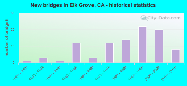
- New bridges - historical statistics
- 11920-1929
- 31930-1939
- 11940-1949
- 121950-1959
- 31960-1969
- 121970-1979
- 141980-1989
- 221990-1999
- 202000-2009
- 82010-2019

- Reconstructed bridges - Historical Statistics
- 11920-1929
- 01930-1939
- 01940-1949
- 01950-1959
- 01960-1969
- 01970-1979
- 71980-1989
- 51990-1999
- 52000-2009


- Bridge Condition - Deck
- 61.7%Good
- 8.5%Satisfactory
- 29.8%Fair

- Bridge Condition - Superstructure
- 72.2%Good
- 13.0%Satisfactory
- 14.8%Fair

- Bridge Condition - Substructure
- 87.0%Good
- 9.3%Satisfactory
- 3.7%Fair

- Bridge Condition - Channel
- 49.4%Excellent
- 16.9%Very good
- 13.0%Good
- 20.8%Satisfactory

- Bridge Condition - Culverts
- 50.0%Good
- 50.0%Satisfactory
Find on map >> Show street view
Structure Number: 24 0017, Location: 03-SAC-099-14.63 (Lat: 38.434603, Lng: -121.400181), Route carried "on" structure: State highway 99, Year Built: 1956, Year Reconstructed: 2007, Status: Open, Structure Length: 1.22m (4.00ft), Average Daily Traffic: 120,000 (year 2009), Truck Traffic: 18%, Average Future Daily Traffic: 196,312 (year 2040), Design Load: HS 20, Features Intersected: WHITEHOUSE CREEK
Minimum Vertical Clearance: 30+ m (98+ ft), Kilometerpoint: 14.630, Lanes on structure: 6, Base Highway Network: Yes (, Subroute: 1), Owner: State Highway Agency, Approaching Roadway Width: 50.0m (164.0ft), Skew: 30 degrees, Material/Design: Concrete continuous, Design/Construction: Slab, Number Of Spans In Main Unit: 3, Length of Maximum Span: 3.7m (12.1ft), Curb-To-Curb Width: 50.0m (164.0ft), Out-to-Out Width: 75.1m (246.4ft)
Condition: Deck: Good, Superstructure: Good, Substructure: Good, Channel: Very good, Operating Rating: 43.4 metric tons, Method Used To Determine Operating Rating: Load Factor (LF), Inventory Rating: 26.2 metric tons, Method Used To Determine Inventory Rating: Load Factor (LF), Structural Evaluation: Equal to present minimum criteria, Deck Geometry: Superior to present desirable criteria, Waterway Adequacy: Equal to present desirable criteria, Approach Roadway Alignment: Equal to present desirable criteria, Designated Inspection Frequency: Every 24 months, Inspection Date: January 2022
Find on map >> Show street view
Structure Number: 24 0018, Location: 03-SAC-099-14.32 (Lat: 38.430511, Lng: -121.398233), Route carried "on" structure: State highway 99, Year Built: 1995, Status: Open, Structure Length: 8.56m (28.08ft), Average Daily Traffic: 120,000 (year 2009), Truck Traffic: 18%, Average Future Daily Traffic: 196,312 (year 2040), Design Load: HS 20+Mod, Features Intersected: LAGUNA CREEK
Minimum Vertical Clearance: 30+ m (98+ ft), Kilometerpoint: 14.320, Lanes on structure: 6, Base Highway Network: Yes (, Subroute: 1), Owner: State Highway Agency, Approaching Roadway Width: 41.5m (136.2ft), Skew: 30 degrees, Material/Design: Concrete continuous, Design/Construction: Slab, Number Of Spans In Main Unit: 7, Length of Maximum Span: 11.0m (36.1ft), Curb-To-Curb Width: 41.5m (136.2ft), Out-to-Out Width: 43.1m (141.4ft)
Condition: Deck: Good, Superstructure: Good, Substructure: Good, Channel: Very good, Operating Rating: 54.1 metric tons, Method Used To Determine Operating Rating: Assigned rating based on Load Factor Design (LFD) reported in metric tons, Inventory Rating: 32.4 metric tons, Method Used To Determine Inventory Rating: Assigned rating based on Load Factor Design (LFD) reported in metric tons, Structural Evaluation: Better than present minimum criteria, Deck Geometry: Superior to present desirable criteria, Waterway Adequacy: Equal to present desirable criteria, Approach Roadway Alignment: Equal to present desirable criteria, Designated Inspection Frequency: Every 24 months, Inspection Date: January 2022, Deck Structure Type: Concrete Cast-file-Place
Find on map >> Show street view
Structure Number: 24 0019, Location: 03-SAC-099-13.00 (Lat: 38.412267, Lng: -121.389950), Route carried "on" structure: State highway 99, Year Built: 1956, Status: Open, Structure Length: 0.76m (2.49ft), Average Daily Traffic: 62,000 (year 2009), Truck Traffic: 15%, Average Future Daily Traffic: 108,598 (year 2040), Features Intersected: ELK GROVE CREEK
Minimum Vertical Clearance: 30+ m (98+ ft), Kilometerpoint: 13.000, Lanes on structure: 8, Base Highway Network: Yes (, Subroute: 1), Owner: State Highway Agency, Approaching Roadway Width: 33.5m (109.9ft), Skew: 32 degrees, Material/Design: Concrete continuous, Design/Construction: Culvert, Number Of Spans In Main Unit: 2, Length of Maximum Span: 3.7m (12.1ft)
Condition: Channel: Satisfactory, Culverts: Good, Operating Rating: 54.1 metric tons, Method Used To Determine Operating Rating: Field evaluation and documented engineering judgment, Inventory Rating: 32.4 metric tons, Method Used To Determine Inventory Rating: Field evaluation and documented engineering judgment, Structural Evaluation: Better than present minimum criteria, Waterway Adequacy: Equal to present minimum criteria, Approach Roadway Alignment: Equal to present desirable criteria, Designated Inspection Frequency: Every 24 months, Inspection Date: January 2022
Find on map >> Show street view
Structure Number: 24 0020R, Location: 03-SAC-099-8.40 (Lat: 38.357411, Lng: -121.343161), Route carried "on" structure: State highway 99, Year Built: 1958, Year Reconstructed: 1993, Status: Open, Structure Length: 20.15m (66.11ft), Average Daily Traffic: 31,500 (year 2009), Truck Traffic: 18%, Average Future Daily Traffic: 55,865 (year 2040), Design Load: HS 20, Features Intersected: COSUMNES RIVER
Minimum Vertical Clearance: 30+ m (98+ ft), Kilometerpoint: 8.400, Lanes on structure: 2, Base Highway Network: Yes (, Subroute: 1), Owner: State Highway Agency, Approaching Roadway Width: 11.8m (38.7ft), Skew: 2 degrees, Material/Design: Concrete continuous, Design/Construction: Tee Beam, Number Of Spans In Main Unit: 4, Number Of Approach Spans: 18, Length of Maximum Span: 16.5m (54.1ft), Curb-To-Curb Width: 11.8m (38.7ft), Out-to-Out Width: 12.7m (41.7ft)
Condition: Deck: Fair, Superstructure: Good, Substructure: Good, Channel: Good, Operating Rating: 29.2 metric tons, Method Used To Determine Operating Rating: Load and Resistance Factor Rating (LRFR) rating reported by rating factor(RF) method using HL-93 loadings, Inventory Rating: 22.4 metric tons, Method Used To Determine Inventory Rating: Load and Resistance Factor Rating (LRFR) rating reported by rating factor(RF) method using HL-93 loadings, Structural Evaluation: Somewhat better than minimum adequacy, Deck Geometry: Better than present minimum criteria, Waterway Adequacy: Equal to present desirable criteria, Approach Roadway Alignment: Equal to present desirable criteria, Designated Inspection Frequency: Every 24 months, Inspection Date: January 2022, Deck Structure Type: Concrete Cast-file-Place
Find on map >> Show street view
Structure Number: 24 0021L, Location: 03-SAC-099-7.92 (Lat: 38.350933, Lng: -121.339817), Route carried "on" structure: State highway 99, Year Built: 1958, Status: Open, Structure Length: 19.51m (64.01ft), Average Daily Traffic: 31,500 (year 2009), Truck Traffic: 18%, Average Future Daily Traffic: 55,865 (year 2040), Design Load: HS 20, Features Intersected: COSUMNES RIVER OVERFLOW
Minimum Vertical Clearance: 30+ m (98+ ft), Kilometerpoint: 7.920, Lanes on structure: 2, Base Highway Network: Yes (, Subroute: 1), Owner: State Highway Agency, Approaching Roadway Width: 8.4m (27.6ft), Skew: 2 degrees, Material/Design: Concrete continuous, Design/Construction: Slab, Number Of Spans In Main Unit: 25, Length of Maximum Span: 7.9m (25.9ft), Curb or Sidewalk Widths: Left: 0.6m (2.0ft), Right: 0.6m (2.0ft), Curb-To-Curb Width: 8.4m (27.6ft), Out-to-Out Width: 9.8m (32.2ft)
Condition: Deck: Good, Superstructure: Good, Substructure: Satisfactory, Channel: Good, Operating Rating: 60.6 metric tons, Method Used To Determine Operating Rating: Load Factor (LF), Inventory Rating: 36.3 metric tons, Method Used To Determine Inventory Rating: Load Factor (LF), Structural Evaluation: Equal to present minimum criteria, Deck Geometry: High priority of corrective action, Waterway Adequacy: Equal to present desirable criteria, Approach Roadway Alignment: Equal to present desirable criteria, Designated Inspection Frequency: Every 24 months, Inspection Date: January 2022, Deck Structure Type: Concrete Cast-file-Place, Wearing Surface/Protective System: Wearing Surface: Bituminous
Find on map >> Show street view
Structure Number: 24 0021R, Location: 03-SAC-099-7.92 (Lat: 38.351144, Lng: -121.339631), Route carried "on" structure: State highway 99, Year Built: 1958, Year Reconstructed: 1993, Status: Open, Structure Length: 19.51m (64.01ft), Average Daily Traffic: 31,500 (year 2009), Truck Traffic: 18%, Average Future Daily Traffic: 55,865 (year 2040), Design Load: HS 20, Features Intersected: COSUMNES RIVER OVERFLOW
Minimum Vertical Clearance: 30+ m (98+ ft), Kilometerpoint: 7.920, Lanes on structure: 2, Base Highway Network: Yes (, Subroute: 1), Owner: State Highway Agency, Approaching Roadway Width: 11.9m (39.0ft), Skew: 2 degrees, Material/Design: Concrete continuous, Design/Construction: Slab, Number Of Spans In Main Unit: 25, Length of Maximum Span: 7.9m (25.9ft), Curb-To-Curb Width: 11.9m (39.0ft), Out-to-Out Width: 12.8m (42.0ft)
Condition: Deck: Satisfactory, Superstructure: Satisfactory, Substructure: Satisfactory, Channel: Very good, Operating Rating: 54.1 metric tons, Method Used To Determine Operating Rating: Assigned rating based on Load Factor Design (LFD) reported in metric tons, Inventory Rating: 32.4 metric tons, Method Used To Determine Inventory Rating: Assigned rating based on Load Factor Design (LFD) reported in metric tons, Structural Evaluation: Equal to present minimum criteria, Deck Geometry: Better than present minimum criteria, Waterway Adequacy: Equal to present desirable criteria, Approach Roadway Alignment: Equal to present desirable criteria, Designated Inspection Frequency: Every 24 months, Inspection Date: January 2022, Deck Structure Type: Concrete Cast-file-Place
Find on map >> Show street view
Structure Number: 24 0022L, Location: 03-SAC-099-7.45 (Lat: 38.344586, Lng: -121.336303), Route carried "on" structure: State highway 99, Year Built: 1958, Year Reconstructed: 1989, Status: Open, Structure Length: 4.79m (15.72ft), Average Daily Traffic: 31,500 (year 2009), Truck Traffic: 18%, Average Future Daily Traffic: 55,865 (year 2040), Design Load: HS 20, Features Intersected: COSUMNES RIVER OVERFLOW
Minimum Vertical Clearance: 30+ m (98+ ft), Kilometerpoint: 7.450, Lanes on structure: 2, Base Highway Network: Yes (, Subroute: 1), Owner: State Highway Agency, Approaching Roadway Width: 12.9m (42.3ft), Skew: 2 degrees, Material/Design: Concrete continuous, Design/Construction: Tee Beam, Number Of Spans In Main Unit: 4, Length of Maximum Span: 13.4m (44.0ft), Curb-To-Curb Width: 11.6m (38.1ft), Out-to-Out Width: 12.5m (41.0ft)
Condition: Deck: Fair, Superstructure: Good, Substructure: Good, Channel: Good, Operating Rating: 41.8 metric tons, Method Used To Determine Operating Rating: Load and Resistance Factor Rating (LRFR) rating reported by rating factor(RF) method using HL-93 loadings, Inventory Rating: 32.4 metric tons, Method Used To Determine Inventory Rating: Load and Resistance Factor Rating (LRFR) rating reported by rating factor(RF) method using HL-93 loadings, Structural Evaluation: Better than present minimum criteria, Deck Geometry: Better than present minimum criteria, Waterway Adequacy: Better than present minimum criteria, Approach Roadway Alignment: Equal to present desirable criteria, Designated Inspection Frequency: Every 24 months, Inspection Date: January 2022, Deck Structure Type: Concrete Cast-file-Place
Find on map >> Show street view
Structure Number: 24 0022R, Location: 03-SAC-099-7.45 (Lat: 38.344747, Lng: -121.336097), Route carried "on" structure: State highway 99, Year Built: 1957, Year Reconstructed: 1994, Status: Open, Structure Length: 4.78m (15.68ft), Average Daily Traffic: 31,500 (year 2009), Truck Traffic: 18%, Average Future Daily Traffic: 55,865 (year 2040), Design Load: HS 20, Features Intersected: COSUMNES RIVER OVERFLOW
Minimum Vertical Clearance: 30+ m (98+ ft), Kilometerpoint: 7.450, Lanes on structure: 2, Base Highway Network: Yes (, Subroute: 1), Owner: State Highway Agency, Approaching Roadway Width: 11.8m (38.7ft), Skew: 2 degrees, Material/Design: Concrete continuous, Design/Construction: Tee Beam, Number Of Spans In Main Unit: 4, Length of Maximum Span: 13.4m (44.0ft), Curb-To-Curb Width: 11.8m (38.7ft), Out-to-Out Width: 12.8m (42.0ft)
Condition: Deck: Fair, Superstructure: Good, Substructure: Good, Channel: Good, Operating Rating: 41.5 metric tons, Method Used To Determine Operating Rating: Load and Resistance Factor Rating (LRFR) rating reported by rating factor(RF) method using HL-93 loadings, Inventory Rating: 29.2 metric tons, Method Used To Determine Inventory Rating: Load and Resistance Factor Rating (LRFR) rating reported by rating factor(RF) method using HL-93 loadings, Structural Evaluation: Better than present minimum criteria, Deck Geometry: Better than present minimum criteria, Waterway Adequacy: Better than present minimum criteria, Approach Roadway Alignment: Equal to present desirable criteria, Designated Inspection Frequency: Every 24 months, Inspection Date: January 2022, Deck Structure Type: Concrete Cast-file-Place
Find on map >> Show street view
Structure Number: 24 0025, Location: 03-SAC-099-6.96 (Lat: 38.337972, Lng: -121.332967), Route carried "on" structure: State highway 99, Year Built: 1993, Status: Open, Structure Length: 6.46m (21.19ft), Average Daily Traffic: 63,000 (year 2009), Truck Traffic: 18%, Average Future Daily Traffic: 111,731 (year 2040), Design Load: HS 20+Mod, Features Intersected: BADGER CREEK
Minimum Vertical Clearance: 30+ m (98+ ft), Kilometerpoint: 6.960, Lanes on structure: 4, Base Highway Network: Yes (, Subroute: 1), Owner: State Highway Agency, Approaching Roadway Width: 34.1m (111.9ft), Skew: 30 degrees, Material/Design: Concrete continuous, Design/Construction: Slab, Number Of Spans In Main Unit: 7, Length of Maximum Span: 9.4m (30.8ft), Curb-To-Curb Width: 34.1m (111.9ft), Out-to-Out Width: 35.7m (117.1ft)
Condition: Deck: Satisfactory, Superstructure: Satisfactory, Substructure: Good, Channel: Very good, Operating Rating: 54.1 metric tons, Method Used To Determine Operating Rating: Assigned rating based on Load Factor Design (LFD) reported in metric tons, Inventory Rating: 32.4 metric tons, Method Used To Determine Inventory Rating: Assigned rating based on Load Factor Design (LFD) reported in metric tons, Structural Evaluation: Equal to present minimum criteria, Deck Geometry: Superior to present desirable criteria, Waterway Adequacy: Superior to present desirable criteria, Approach Roadway Alignment: Equal to present desirable criteria, Designated Inspection Frequency: Every 24 months, Inspection Date: January 2022, Deck Structure Type: Concrete Cast-file-Place
Find on map >> Show street view
Structure Number: 24 0073R, Location: 03-SAC-099-8.81 (Lat: 38.362458, Lng: -121.346886), Route carried "on" structure: State highway 99, Year Built: 1958, Year Reconstructed: 1993, Status: Open, Structure Length: 8.41m (27.59ft), Average Daily Traffic: 31,500 (year 2009), Truck Traffic: 18%, Average Future Daily Traffic: 55,865 (year 2040), Design Load: HS 20, Features Intersected: UP RR, BNSF RY, & AMTRAK
Minimum Vertical Clearance: 30+ m (98+ ft), Kilometerpoint: 8.810, Lanes on structure: 2, Base Highway Network: Yes (, Subroute: 1), Owner: State Highway Agency, Approaching Roadway Width: 11.9m (39.0ft), Skew: 6 degrees, Material/Design: Steel, Design/Construction: Stringer/Multi-beam, Number Of Spans In Main Unit: 3, Length of Maximum Span: 27.9m (91.5ft), Curb-To-Curb Width: 11.9m (39.0ft), Out-to-Out Width: 12.9m (42.3ft)
Condition: Deck: Fair, Superstructure: Satisfactory, Substructure: Good, Operating Rating: 71.0 metric tons, Method Used To Determine Operating Rating: Load Factor (LF), Inventory Rating: 42.4 metric tons, Method Used To Determine Inventory Rating: Load Factor (LF), Structural Evaluation: Equal to present minimum criteria, Deck Geometry: Better than present minimum criteria, Underclear: Meets minimum limits, Approach Roadway Alignment: Equal to present desirable criteria, Designated Inspection Frequency: Every 24 months, Inspection Date: January 2022, Deck Structure Type: Concrete Cast-file-Place
Find on map >> Show street view
Structure Number: 24 0163, Location: 03-SAC-099-7.36 (Lat: 38.343417, Lng: -121.335914), Route carried "on" structure: County highway , Year Built: 1958, Status: Open, Structure Length: 5.30m (17.39ft), Average Daily Traffic: 2,470 (year 1998), Truck Traffic: 12%, Average Future Daily Traffic: 5,379 (year 2042), Design Load: HS 20, Features Intersected: STATE ROUTE 99, Facility Carried by Structure: DILLARD ROAD
Minimum Vertical Clearance: 30+ m (98+ ft), Kilometerpoint: 0.000, Lanes on structure: 2, Lanes under structure: 4, Owner: State Highway Agency, Approaching Roadway Width: 9.8m (32.2ft), Material/Design: Prestressed concrete, Design/Construction: Tee Beam, Number Of Spans In Main Unit: 2, Number Of Approach Spans: 2, Length of Maximum Span: 18.0m (59.1ft), Curb-To-Curb Width: 9.8m (32.2ft), Out-to-Out Width: 10.9m (35.8ft)
Condition: Deck: Good, Superstructure: Good, Substructure: Good, Operating Rating: 32.4 metric tons, Method Used To Determine Operating Rating: Load and Resistance Factor Rating (LRFR) rating reported by rating factor(RF) method using HL-93 loadings, Inventory Rating: 26.2 metric tons, Method Used To Determine Inventory Rating: Load and Resistance Factor Rating (LRFR) rating reported by rating factor(RF) method using HL-93 loadings, Structural Evaluation: Equal to present minimum criteria, Deck Geometry: Meets minimum limits, Underclear: Meets minimum limits, Approach Roadway Alignment: Equal to present desirable criteria, Designated Inspection Frequency: Every 24 months, Inspection Date: January 2022, Deck Structure Type: Concrete Cast-file-Place, Wearing Surface/Protective System: Wearing Surface: Bituminous
Find on map >> Show street view
Structure Number: 24 0262L, Location: 03-SAC-005-12.92 (Lat: 38.438864, Lng: -121.490078), Route carried "on" structure: Interstate 5, Year Built: 1975, Year Reconstructed: 1996, Status: Open, Structure Length: 17.59m (57.71ft), Average Daily Traffic: 46,500 (year 2015), Average Future Daily Traffic: 36,140 (year 2040), Design Load: HS 20, Features Intersected: BEACH LAKE
Minimum Vertical Clearance: 30+ m (98+ ft), Kilometerpoint: 12.920, Lanes on structure: 3, Base Highway Network: Yes (, Subroute: 1), Owner: State Highway Agency, Approaching Roadway Width: 20.0m (65.6ft), Skew: 3 degrees, Material/Design: Concrete continuous, Design/Construction: Tee Beam, Number Of Spans In Main Unit: 13, Length of Maximum Span: 13.7m (44.9ft), Curb-To-Curb Width: 17.1m (56.1ft), Out-to-Out Width: 18.1m (59.4ft)
Condition: Deck: Good, Superstructure: Good, Substructure: Good, Channel: Satisfactory, Operating Rating: 40.8 metric tons, Method Used To Determine Operating Rating: Load Factor (LF), Inventory Rating: 24.6 metric tons, Method Used To Determine Inventory Rating: Load Factor (LF), Structural Evaluation: Equal to present minimum criteria, Deck Geometry: Equal to present minimum criteria, Waterway Adequacy: Equal to present desirable criteria, Approach Roadway Alignment: Equal to present desirable criteria, Designated Inspection Frequency: Every 24 months, Inspection Date: June 2020, Deck Structure Type: Concrete Cast-file-Place, Wearing Surface/Protective System: Wearing Surface: Epoxy Overlay
Find on map >> Show street view
Structure Number: 24 0262R, Location: 03-SAC-005-12.93 (Lat: 38.439031, Lng: -121.489775), Route carried "on" structure: Interstate 5, Year Built: 1975, Year Reconstructed: 1996, Status: Open, Structure Length: 17.59m (57.71ft), Average Daily Traffic: 46,500 (year 2015), Average Future Daily Traffic: 36,140 (year 2040), Design Load: HS 20, Features Intersected: BEACH LAKE
Minimum Vertical Clearance: 30+ m (98+ ft), Kilometerpoint: 12.930, Lanes on structure: 3, Base Highway Network: Yes (, Subroute: 1), Owner: State Highway Agency, Approaching Roadway Width: 20.0m (65.6ft), Skew: 3 degrees, Material/Design: Concrete continuous, Design/Construction: Tee Beam, Number Of Spans In Main Unit: 13, Length of Maximum Span: 13.7m (44.9ft), Curb-To-Curb Width: 17.1m (56.1ft), Out-to-Out Width: 18.1m (59.4ft)
Condition: Deck: Good, Superstructure: Good, Substructure: Good, Channel: Satisfactory, Operating Rating: 40.8 metric tons, Method Used To Determine Operating Rating: Load Factor (LF), Inventory Rating: 24.6 metric tons, Method Used To Determine Inventory Rating: Load Factor (LF), Structural Evaluation: Equal to present minimum criteria, Deck Geometry: Equal to present minimum criteria, Waterway Adequacy: Equal to present desirable criteria, Approach Roadway Alignment: Equal to present desirable criteria, Designated Inspection Frequency: Every 24 months, Inspection Date: June 2020, Deck Structure Type: Concrete Cast-file-Place, Wearing Surface/Protective System: Wearing Surface: Epoxy Overlay
Find on map >> Show street view
Structure Number: 24 0346, Location: 03-SAC-005-9.38 (Lat: 38.388108, Lng: -121.479192), Route carried "on" structure: Interstate 5, Year Built: 1975, Status: Open, Structure Length: 1.19m (3.90ft), Average Daily Traffic: 55,000 (year 2015), Truck Traffic: 21%, Average Future Daily Traffic: 113,616 (year 2040), Features Intersected: STONE LAKE
Minimum Vertical Clearance: 30+ m (98+ ft), Kilometerpoint: 9.380, Lanes on structure: 4, Base Highway Network: Yes (, Subroute: 1), Owner: State Highway Agency, Approaching Roadway Width: 24.2m (79.4ft), Skew: 20 degrees, Material/Design: Concrete continuous, Design/Construction: Culvert, Number Of Spans In Main Unit: 3, Length of Maximum Span: 3.7m (12.1ft)
Condition: Channel: Satisfactory, Culverts: Satisfactory, Operating Rating: 54.1 metric tons, Method Used To Determine Operating Rating: Field evaluation and documented engineering judgment, Inventory Rating: 32.4 metric tons, Method Used To Determine Inventory Rating: Field evaluation and documented engineering judgment, Structural Evaluation: Equal to present minimum criteria, Waterway Adequacy: Equal to present desirable criteria, Approach Roadway Alignment: Equal to present desirable criteria, Designated Inspection Frequency: Every 24 months, Inspection Date: May 2020
Find on map >> Show street view
Structure Number: 24 0347, Location: 03-SAC-005-12.40 (Lat: 38.431361, Lng: -121.488164), Route carried "on" structure: Interstate 5, Year Built: 1975, Status: Open, Structure Length: 1.16m (3.81ft), Average Daily Traffic: 93,000 (year 2015), Average Future Daily Traffic: 106,090 (year 2040), Features Intersected: SOUTH REACH BEACH LAKE
Minimum Vertical Clearance: 30+ m (98+ ft), Kilometerpoint: 12.400, Lanes on structure: 9, Base Highway Network: Yes (, Subroute: 1), Owner: State Highway Agency, Approaching Roadway Width: 58.4m (191.6ft), Skew: 30 degrees, Material/Design: Concrete continuous, Design/Construction: Culvert, Number Of Spans In Main Unit: 3, Length of Maximum Span: 3.7m (12.1ft)
Condition: Channel: Satisfactory, Culverts: Good, Operating Rating: 54.1 metric tons, Method Used To Determine Operating Rating: Field evaluation and documented engineering judgment, Inventory Rating: 32.4 metric tons, Method Used To Determine Inventory Rating: Field evaluation and documented engineering judgment, Structural Evaluation: Better than present minimum criteria, Waterway Adequacy: Equal to present desirable criteria, Approach Roadway Alignment: Equal to present desirable criteria, Designated Inspection Frequency: Every 24 months, Inspection Date: June 2020
Find on map >> Show street view
Structure Number: 24 0358, Location: 03-SAC-099-13.66 (Lat: 38.423708, Lng: -121.395803), Route carried "on" structure: County highway , Year Built: 1990, Status: Open, Structure Length: 7.31m (23.98ft), Average Daily Traffic: 10,000 (year 1998), Truck Traffic: 5%, Average Future Daily Traffic: 21,519 (year 2042), Design Load: HS 20+Mod, Features Intersected: STATE ROUTE 99, Facility Carried by Structure: LAGUNA BLVD
Minimum Vertical Clearance: 30+ m (98+ ft), Kilometerpoint: 0.000, Lanes on structure: 7, Lanes under structure: 6, Owner: State Highway Agency, Approaching Roadway Width: 28.4m (93.2ft), Skew: 31 degrees, Material/Design: Prestressed concrete continuous, Design/Construction: Box Beam or Girders - Multiple, Number Of Spans In Main Unit: 2, Length of Maximum Span: 36.2m (118.8ft), Curb or Sidewalk Widths: Left: 1.5m (4.9ft), Right: 1.5m (4.9ft), Curb-To-Curb Width: 28.4m (93.2ft), Out-to-Out Width: 32.6m (107.0ft)
Condition: Deck: Fair, Superstructure: Satisfactory, Substructure: Satisfactory, Operating Rating: 54.1 metric tons, Method Used To Determine Operating Rating: Assigned rating based on Load Factor Design (LFD) reported in metric tons, Inventory Rating: 32.4 metric tons, Method Used To Determine Inventory Rating: Assigned rating based on Load Factor Design (LFD) reported in metric tons, Structural Evaluation: Equal to present minimum criteria, Deck Geometry: Somewhat better than minimum adequacy, Underclear: Equal to present minimum criteria, Approach Roadway Alignment: Equal to present desirable criteria, Designated Inspection Frequency: Every 24 months, Inspection Date: January 2022, Deck Structure Type: Concrete Cast-file-Place
Find on map >> Show street view
Structure Number: 24 0359, Location: 03-SAC-005-12.04 (Lat: 38.426283, Lng: -121.487792), Route carried "on" structure: County highway , Year Built: 1992, Status: Open, Structure Length: 8.41m (27.59ft), Average Daily Traffic: 5,000 (year 2015), Truck Traffic: 5%, Average Future Daily Traffic: 10,547 (year 2040), Design Load: HS 20+Mod, Features Intersected: INTERSTATE 5, Facility Carried by Structure: LAGUNA BLVD
Minimum Vertical Clearance: 30+ m (98+ ft), Kilometerpoint: 0.000, Lanes on structure: 3, Lanes under structure: 6, Base Highway Network: Yes, Owner: State Highway Agency, Approaching Roadway Width: 18.0m (59.1ft), Skew: 9 degrees, Material/Design: Concrete continuous, Design/Construction: Box Beam or Girders - Multiple, Number Of Spans In Main Unit: 2, Length of Maximum Span: 45.1m (148.0ft), Curb-To-Curb Width: 17.7m (58.1ft), Out-to-Out Width: 18.7m (61.4ft)
Condition: Deck: Good, Superstructure: Good, Substructure: Good, Operating Rating: 54.1 metric tons, Method Used To Determine Operating Rating: Assigned rating based on Load Factor Design (LFD) reported in metric tons, Inventory Rating: 32.4 metric tons, Method Used To Determine Inventory Rating: Assigned rating based on Load Factor Design (LFD) reported in metric tons, Structural Evaluation: Better than present minimum criteria, Deck Geometry: Superior to present desirable criteria, Underclear: Better than present minimum criteria, Approach Roadway Alignment: Equal to present desirable criteria, Designated Inspection Frequency: Every 24 months, Inspection Date: June 2020, Deck Structure Type: Concrete Cast-file-Place
Find on map >> Show street view
Structure Number: 24 036, Location: 03-SAC-099-15.80-SAC (Lat: 38.456714, Lng: -121.410889), Route carried "on" structure: County highway , Year Built: 1995, Status: Open, Structure Length: 8.63m (28.31ft), Average Daily Traffic: 2,000 (year 1998), Truck Traffic: 5%, Average Future Daily Traffic: 5,508 (year 2042), Features Intersected: STATE ROUTE 99, Facility Carried by Structure: CALVINE ROAD
Minimum Vertical Clearance: 30+ m (98+ ft), Kilometerpoint: 0.000, Lanes on structure: 8, Lanes under structure: 6, Owner: State Highway Agency, Approaching Roadway Width: 33.6m (110.2ft), Skew: 23 degrees, Material/Design: Prestressed concrete continuous, Design/Construction: Box Beam or Girders - Multiple, Number Of Spans In Main Unit: 2, Length of Maximum Span: 43.1m (141.4ft), Curb or Sidewalk Widths: Left: 0.0m, Right: 1.8m (5.9ft), Curb-To-Curb Width: 33.6m (110.2ft), Out-to-Out Width: 36.8m (120.7ft)
Condition: Deck: Satisfactory, Superstructure: Good, Substructure: Fair, Operating Rating: 54.1 metric tons, Method Used To Determine Operating Rating: Field evaluation and documented engineering judgment, Inventory Rating: 32.4 metric tons, Method Used To Determine Inventory Rating: Field evaluation and documented engineering judgment, Structural Evaluation: Somewhat better than minimum adequacy, Deck Geometry: Equal to present minimum criteria, Underclear: Equal to present minimum criteria, Approach Roadway Alignment: Equal to present desirable criteria, Designated Inspection Frequency: Every 24 months, Inspection Date: January 2022, Deck Structure Type: Concrete Cast-file-Place
Find on map >> Show street view
Structure Number: 24 0361, Location: 03-SAC-099-12.76 (Lat: 38.408972, Lng: -121.388975), Route carried "on" structure: City street , Year Built: 1997, Status: Open, Structure Length: 6.60m (21.65ft), Average Daily Traffic: 1,200 (year 2003), Truck Traffic: 1%, Average Future Daily Traffic: 4,303 (year 2042), Design Load: HS 20+Mod, Features Intersected: STATE ROUTE 99, Facility Carried by Structure: ELK GROVE BLVD
Minimum Vertical Clearance: 30+ m (98+ ft), Kilometerpoint: 0.000, Lanes on structure: 7, Lanes under structure: 6, Base Highway Network: Yes, Owner: State Highway Agency, Approaching Roadway Width: 33.3m (109.3ft), Skew: 21 degrees, Material/Design: Prestressed concrete continuous, Design/Construction: Box Beam or Girders - Multiple, Number Of Spans In Main Unit: 2, Length of Maximum Span: 34.6m (113.5ft), Curb or Sidewalk Widths: Left: 1.5m (4.9ft), Right: 1.5m (4.9ft), Curb-To-Curb Width: 28.6m (93.8ft), Out-to-Out Width: 36.6m (120.1ft)
Condition: Deck: Good, Superstructure: Good, Substructure: Good, Operating Rating: 54.1 metric tons, Method Used To Determine Operating Rating: Assigned rating based on Load Factor Design (LFD) reported in metric tons, Inventory Rating: 32.4 metric tons, Method Used To Determine Inventory Rating: Assigned rating based on Load Factor Design (LFD) reported in metric tons, Structural Evaluation: Better than present minimum criteria, Deck Geometry: Somewhat better than minimum adequacy, Underclear: Equal to present minimum criteria, Approach Roadway Alignment: Equal to present desirable criteria, Designated Inspection Frequency: Every 24 months, Inspection Date: January 2022, Deck Structure Type: Concrete Cast-file-Place
Find on map >> Show street view
Structure Number: 24 0367, Location: 03-SAC-099-10.07-ELKG (Lat: 38.376097, Lng: -121.362250), Route carried "on" structure: City street , Year Built: 2009, Status: Open, Structure Length: 8.21m (26.94ft), Average Daily Traffic: 1,500 (year 2010), Truck Traffic: 1%, Average Future Daily Traffic: 3,123 (year 2042), Design Load: HS 20+Mod, Features Intersected: STATE ROUTE 99, Facility Carried by Structure: GRANT LINE ROAD
Minimum Vertical Clearance: 30+ m (98+ ft), Kilometerpoint: 0.000, Lanes on structure: 7, Lanes under structure: 4, Base Highway Network: Yes, Owner: State Highway Agency, Approaching Roadway Width: 39.0m (128.0ft), Skew: 20 degrees, Material/Design: Prestressed concrete continuous, Design/Construction: Box Beam or Girders - Multiple, Number Of Spans In Main Unit: 2, Length of Maximum Span: 41.5m (136.2ft), Curb or Sidewalk Widths: Left: 1.5m (4.9ft), Right: 1.5m (4.9ft), Curb-To-Curb Width: 39.0m (128.0ft), Out-to-Out Width: 42.6m (139.8ft)
Condition: Deck: Good, Superstructure: Good, Substructure: Good, Operating Rating: 54.1 metric tons, Method Used To Determine Operating Rating: Assigned rating based on Load Factor Design (LFD) reported in metric tons, Inventory Rating: 32.4 metric tons, Method Used To Determine Inventory Rating: Assigned rating based on Load Factor Design (LFD) reported in metric tons, Structural Evaluation: Better than present minimum criteria, Deck Geometry: Superior to present desirable criteria, Underclear: Equal to present minimum criteria, Approach Roadway Alignment: Equal to present desirable criteria, Designated Inspection Frequency: Every 24 months, Inspection Date: January 2022, Deck Structure Type: Concrete Cast-file-Place
Find on map >> Show street view
Structure Number: 24 0374, Location: 03-SAC-099-14.87-ELKG (Lat: 38.437633, Lng: -121.402164), Route carried "on" structure: City street , Year Built: 2010, Status: Open, Structure Length: 8.30m (27.23ft), Average Daily Traffic: 12,000 (year 2010), Truck Traffic: 16%, Average Future Daily Traffic: 20,814 (year 2042), Design Load: HS 20, Features Intersected: STATE ROUTE 99, Facility Carried by Structure: SHELDON ROAD
Minimum Vertical Clearance: 30+ m (98+ ft), Kilometerpoint: 14.870, Lanes on structure: 9, Lanes under structure: 9, Owner: State Highway Agency, Approaching Roadway Width: 41.1m (134.8ft), Skew: 22 degrees, Material/Design: Prestressed concrete continuous, Design/Construction: Box Beam or Girders - Multiple, Number Of Spans In Main Unit: 2, Length of Maximum Span: 43.5m (142.7ft), Curb or Sidewalk Widths: Left: 1.8m (5.9ft), Right: 1.8m (5.9ft), Curb-To-Curb Width: 41.1m (134.8ft), Out-to-Out Width: 45.3m (148.6ft)
Condition: Deck: Satisfactory, Superstructure: Good, Substructure: Good, Operating Rating: 54.1 metric tons, Method Used To Determine Operating Rating: Assigned rating based on Load Factor Design (LFD) reported in metric tons, Inventory Rating: 32.4 metric tons, Method Used To Determine Inventory Rating: Assigned rating based on Load Factor Design (LFD) reported in metric tons, Structural Evaluation: Better than present minimum criteria, Deck Geometry: Superior to present desirable criteria, Underclear: Equal to present minimum criteria, Approach Roadway Alignment: Better than present minimum criteria, Designated Inspection Frequency: Every 24 months, Inspection Date: January 2022, Deck Structure Type: Concrete Cast-file-Place
Find on map >> Show street view
Structure Number: 24C0018, Location: 0.4 MI SW CALVINE RD (Lat: 38.448717, Lng: -121.280703), Route carried "on" structure: County highway , Year Built: 1939, Year Reconstructed: 1990, Status: Open, Structure Length: 2.50m (8.20ft), Average Daily Traffic: 14,664 (year 2014), Truck Traffic: 10%, Average Future Daily Traffic: 23,751 (year 2043), Features Intersected: EAST BRANCH LAGUNA CREEK, Facility Carried by Structure: GRANT LINE RD
Minimum Vertical Clearance: 30+ m (98+ ft), Kilometerpoint: 0.000, Lanes on structure: 2, Owner: City or Municipal Highway Agency, Approaching Roadway Width: 12.8m (42.0ft), Material/Design: Concrete continuous, Design/Construction: Slab, Number Of Spans In Main Unit: 5, Length of Maximum Span: 6.7m (22.0ft), Curb or Sidewalk Widths: Left: 0.7m (2.3ft), Right: 0.1m (0.3ft), Curb-To-Curb Width: 12.2m (40.0ft), Out-to-Out Width: 13.0m (42.7ft)
Condition: Deck: Good, Superstructure: Good, Substructure: Good, Channel: Satisfactory, Operating Rating: 36.3 metric tons, Method Used To Determine Operating Rating: Load Factor (LF), Inventory Rating: 21.7 metric tons, Method Used To Determine Inventory Rating: Load Factor (LF), Structural Evaluation: Somewhat better than minimum adequacy, Deck Geometry: Somewhat better than minimum adequacy, Waterway Adequacy: Equal to present minimum criteria, Approach Roadway Alignment: Equal to present desirable criteria, Designated Inspection Frequency: Every 24 months, Inspection Date: April 2021, Deck Structure Type: Concrete Cast-file-Place, Wearing Surface/Protective System: Wearing Surface: Bituminous
Find on map >> Show street view
Structure Number: 24C005, Location: 0.9 MI N OF ELK GROVE BL (Lat: 38.421294, Lng: -121.371467), Route carried "on" structure: County highway , Year Built: 1947, Year Reconstructed: 1993, Status: Open, Structure Length: 3.75m (12.30ft), Average Daily Traffic: 19,800 (year 2014), Truck Traffic: 5%, Average Future Daily Traffic: 32,497 (year 2043), Design Load: HS 20, Features Intersected: LAGUNA CREEK, Facility Carried by Structure: ELK GROVE-FLORIN R
Minimum Vertical Clearance: 30+ m (98+ ft), Kilometerpoint: 0.000, Lanes on structure: 4, Owner: City or Municipal Highway Agency, Approaching Roadway Width: 20.7m (67.9ft), Material/Design: Concrete continuous, Design/Construction: Slab, Number Of Spans In Main Unit: 6, Length of Maximum Span: 6.7m (22.0ft), Curb or Sidewalk Widths: Left: 3.6m (11.8ft), Right: 1.5m (4.9ft), Curb-To-Curb Width: 20.7m (67.9ft), Out-to-Out Width: 27.1m (88.9ft)
Condition: Deck: Good, Superstructure: Good, Substructure: Satisfactory, Channel: Satisfactory, Operating Rating: 43.4 metric tons, Method Used To Determine Operating Rating: Load Factor (LF), Inventory Rating: 25.9 metric tons, Method Used To Determine Inventory Rating: Load Factor (LF), Structural Evaluation: Equal to present minimum criteria, Deck Geometry: Superior to present desirable criteria, Waterway Adequacy: Better than present minimum criteria, Approach Roadway Alignment: Equal to present desirable criteria, Length Of Structure Improvement: 3.69m (12.11ft), Designated Inspection Frequency: Every 24 months, Inspection Date: April 2021, Deck Structure Type: Concrete Cast-file-Place, Wearing Surface/Protective System: Wearing Surface: Bituminous
Find on map >> Show street view
Structure Number: 24C0051, Location: 0.3 MI S ELK GROVE BLVD (Lat: 38.403147, Lng: -121.371375), Route carried "on" structure: County highway , Year Built: 1976, Status: Open, Structure Length: 0.75m (2.46ft), Average Daily Traffic: 8,900 (year 2014), Truck Traffic: 10%, Average Future Daily Traffic: 13,537 (year 2041), Features Intersected: ELK GROVE CREEK, Facility Carried by Structure: ELK GRVE-FLORIN RD
Minimum Vertical Clearance: 30+ m (98+ ft), Kilometerpoint: 0.000, Lanes on structure: 2, Owner: City or Municipal Highway Agency, Approaching Roadway Width: 17.4m (57.1ft), Material/Design: Concrete continuous, Design/Construction: Culvert, Number Of Spans In Main Unit: 2, Length of Maximum Span: 3.7m (12.1ft), Curb or Sidewalk Widths: Left: 1.5m (4.9ft), Right: 1.8m (5.9ft), Curb-To-Curb Width: 17.4m (57.1ft), Out-to-Out Width: 21.3m (69.9ft)
Condition: Channel: Excellent, Culverts: Good, Operating Rating: 54.1 metric tons, Method Used To Determine Operating Rating: Field evaluation and documented engineering judgment, Inventory Rating: 32.4 metric tons, Method Used To Determine Inventory Rating: Field evaluation and documented engineering judgment, Structural Evaluation: Better than present minimum criteria, Deck Geometry: Superior to present desirable criteria, Waterway Adequacy: Equal to present desirable criteria, Approach Roadway Alignment: Equal to present desirable criteria, Designated Inspection Frequency: Every 48 months, Inspection Date: April 2019
Find on map >> Show street view
Structure Number: 24C0079, Location: 1.0 MI E GRANT LINE RD (Lat: 38.420592, Lng: -121.285486), Route carried "on" structure: County highway , Year Built: 1957, Year Reconstructed: 1993, Status: Open, Structure Length: 29.34m (96.26ft), Average Daily Traffic: 11,000 (year 2007), Truck Traffic: 3%, Average Future Daily Traffic: 17,445 (year 2043), Design Load: HS 20+Mod, Features Intersected: DEER CREEK, Facility Carried by Structure: WILTON RD
Minimum Vertical Clearance: 30+ m (98+ ft), Kilometerpoint: 0.000, Lanes on structure: 2, Owner: City or Municipal Highway Agency, Approaching Roadway Width: 10.1m (33.1ft), Material/Design: Concrete continuous, Design/Construction: Slab, Number Of Spans In Main Unit: 40, Length of Maximum Span: 7.3m (24.0ft), Curb-To-Curb Width: 9.1m (29.9ft), Out-to-Out Width: 9.3m (30.5ft)
Condition: Deck: Fair, Superstructure: Fair, Substructure: Good, Channel: Very good, Operating Rating: 54.1 metric tons, Method Used To Determine Operating Rating: Assigned rating based on Load Factor Design (LFD) reported in metric tons, Inventory Rating: 32.4 metric tons, Method Used To Determine Inventory Rating: Assigned rating based on Load Factor Design (LFD) reported in metric tons, Structural Evaluation: Somewhat better than minimum adequacy, Deck Geometry: Meets minimum limits, Waterway Adequacy: Superior to present desirable criteria, Approach Roadway Alignment: Equal to present desirable criteria, Designated Inspection Frequency: Every 24 months, Inspection Date: April 2021, Deck Structure Type: Concrete Cast-file-Place
Find on map >> Show street view
Structure Number: 24C0151, Location: 50 FT N OF LAMBERT RD (Lat: 38.321150, Lng: -121.444556), Route carried "on" structure: County highway , Year Built: 1925, Year Reconstructed: 1933, Status: Open, Structure Length: 0.73m (2.40ft), Average Daily Traffic: 2,346 (year 2009), Truck Traffic: 10%, Average Future Daily Traffic: 2,886 (year 2040), Features Intersected: DRAINAGE DITCH, Facility Carried by Structure: FRANKLIN BLVD
Minimum Vertical Clearance: 30+ m (98+ ft), Kilometerpoint: 0.000, Lanes on structure: 2, Owner: County Highway Agency, Approaching Roadway Width: 10.4m (34.1ft), Material/Design: Concrete continuous, Design/Construction: Slab, Number Of Spans In Main Unit: 2, Length of Maximum Span: 3.2m (10.5ft), Curb or Sidewalk Widths: Left: 0.7m (2.3ft), Right: 0.7m (2.3ft), Curb-To-Curb Width: 10.7m (35.1ft), Out-to-Out Width: 12.3m (40.4ft)
Condition: Deck: Good, Superstructure: Good, Substructure: Good, Channel: Satisfactory, Operating Rating: 26.9 metric tons, Method Used To Determine Operating Rating: Field evaluation and documented engineering judgment, Inventory Rating: 16.2 metric tons, Method Used To Determine Inventory Rating: Field evaluation and documented engineering judgment, Structural Evaluation: Meets minimum limits, Deck Geometry: Somewhat better than minimum adequacy, Waterway Adequacy: Equal to present minimum criteria, Approach Roadway Alignment: Equal to present desirable criteria, Designated Inspection Frequency: Every 24 months, Inspection Date: October 2020, Deck Structure Type: Concrete Cast-file-Place, Wearing Surface/Protective System: Wearing Surface: Bituminous
Find on map >> Show street view
Structure Number: 24C0157, Location: 0.8 MI N HOOD-FRANKLIN RD (Lat: 38.390253, Lng: -121.452836), Route carried "on" structure: County highway , Year Built: 1933, Status: Open, Structure Length: 1.04m (3.41ft), Average Daily Traffic: 2,346 (year 2009), Truck Traffic: 10%, Average Future Daily Traffic: 2,971 (year 2039), Features Intersected: STONE LAKE DRAIN, Facility Carried by Structure: FRANKLIN BLVD
Minimum Vertical Clearance: 30+ m (98+ ft), Kilometerpoint: 0.000, Lanes on structure: 2, Owner: County Highway Agency, Approaching Roadway Width: 9.1m (29.9ft), Material/Design: Concrete continuous, Design/Construction: Slab, Number Of Spans In Main Unit: 3, Length of Maximum Span: 3.6m (11.8ft), Curb-To-Curb Width: 9.1m (29.9ft), Out-to-Out Width: 10.1m (33.1ft)
Condition: Deck: Good, Superstructure: Good, Substructure: Fair, Channel: Satisfactory, Operating Rating: 52.5 metric tons, Method Used To Determine Operating Rating: Load Factor (LF), Inventory Rating: 31.8 metric tons, Method Used To Determine Inventory Rating: Load Factor (LF), Structural Evaluation: Somewhat better than minimum adequacy, Deck Geometry: Meets minimum limits, Waterway Adequacy: Equal to present minimum criteria, Approach Roadway Alignment: Equal to present desirable criteria, Designated Inspection Frequency: Every 24 months, Inspection Date: October 2020, Deck Structure Type: Concrete Cast-file-Place, Wearing Surface/Protective System: Wearing Surface: Bituminous
Find on map >> Show street view
Structure Number: 24C0158, Location: 0.2 MI S ELK GROVE BLVD (Lat: 38.406589, Lng: -121.450072), Route carried "on" structure: County highway , Year Built: 2003, Status: Open, Structure Length: 1.05m (3.44ft), Average Daily Traffic: 6,440 (year 2007), Truck Traffic: 10%, Average Future Daily Traffic: 8,177 (year 2042), Features Intersected: SHED A CHNNL (EHRHARDT), Facility Carried by Structure: FRANKLIN BLVD
Minimum Vertical Clearance: 30+ m (98+ ft), Kilometerpoint: 0.000, Lanes on structure: 5, Owner: City or Municipal Highway Agency, Approaching Roadway Width: 16.5m (54.1ft), Skew: 20 degrees, Material/Design: Concrete continuous, Design/Construction: Culvert, Number Of Spans In Main Unit: 4, Length of Maximum Span: 2.4m (7.9ft), Curb or Sidewalk Widths: Left: 0.2m (0.7ft), Right: 2.0m (6.6ft), Curb-To-Curb Width: 27.4m (89.9ft), Out-to-Out Width: 32.3m (106.0ft)
Condition: Channel: Satisfactory, Culverts: Satisfactory, Operating Rating: 54.1 metric tons, Method Used To Determine Operating Rating: Field evaluation and documented engineering judgment, Inventory Rating: 32.4 metric tons, Method Used To Determine Inventory Rating: Field evaluation and documented engineering judgment, Structural Evaluation: Equal to present minimum criteria, Deck Geometry: Superior to present desirable criteria, Waterway Adequacy: Equal to present minimum criteria, Approach Roadway Alignment: Equal to present desirable criteria, Length Of Structure Improvement: 1.74m (5.71ft), Designated Inspection Frequency: Every 48 months, Inspection Date: October 2020, Deck Structure Type: Concrete Cast-file-Place, Wearing Surface/Protective System: Wearing Surface: Bituminous
Find on map >> Show street view
Structure Number: 24C0192, Location: 0.4 MI E OF SH 99 (Lat: 38.346075, Lng: -121.331497), Route carried "on" structure: County highway , Year Built: 1973, Status: Open, Structure Length: 3.73m (12.24ft), Average Daily Traffic: 2,920 (year 2007), Truck Traffic: 10%, Average Future Daily Traffic: 3,712 (year 2042), Design Load: HS 20, Features Intersected: COSUMNES RIVER OVERFLOW, Facility Carried by Structure: DILLARD RD
Minimum Vertical Clearance: 30+ m (98+ ft), Kilometerpoint: 0.000, Lanes on structure: 2, Owner: County Highway Agency, Approaching Roadway Width: 7.6m (24.9ft), Material/Design: Concrete continuous, Design/Construction: Slab, Number Of Spans In Main Unit: 5, Length of Maximum Span: 8.2m (26.9ft), Curb-To-Curb Width: 11.0m (36.1ft), Out-to-Out Width: 11.2m (36.7ft)
Condition: Deck: Good, Superstructure: Good, Substructure: Good, Channel: Satisfactory, Operating Rating: 45.0 metric tons, Method Used To Determine Operating Rating: Load and Resistance Factor Rating (LRFR) rating reported by rating factor(RF) method using HL-93 loadings, Inventory Rating: 31.8 metric tons, Method Used To Determine Inventory Rating: Load and Resistance Factor Rating (LRFR) rating reported by rating factor(RF) method using HL-93 loadings, Structural Evaluation: Better than present minimum criteria, Deck Geometry: Somewhat better than minimum adequacy, Waterway Adequacy: Superior to present desirable criteria, Approach Roadway Alignment: Equal to present desirable criteria, Designated Inspection Frequency: Every 24 months, Inspection Date: October 2020, Deck Structure Type: Concrete Cast-file-Place, Wearing Surface/Protective System: Wearing Surface: Bituminous
Find on map >> Show street view
Structure Number: 24C0193, Location: 0.5 MI EAST OF S.R. 99 (Lat: 38.408853, Lng: -121.378642), Route carried "on" structure: County highway , Year Built: 1976, Status: Open, Structure Length: 2.03m (6.66ft), Average Daily Traffic: 29,869 (year 2011), Truck Traffic: 10%, Average Future Daily Traffic: 49,000 (year 2036), Design Load: HS 20, Features Intersected: ELK GROVE CREEK, Facility Carried by Structure: ELK GROVE BLVD
Minimum Vertical Clearance: 30+ m (98+ ft), Kilometerpoint: 0.000, Lanes on structure: 5, Base Highway Network: Yes, Owner: City or Municipal Highway Agency, Approaching Roadway Width: 22.9m (75.1ft), Material/Design: Concrete continuous, Design/Construction: Slab, Number Of Spans In Main Unit: 2, Length of Maximum Span: 9.8m (32.2ft), Curb or Sidewalk Widths: Left: 1.5m (4.9ft), Right: 1.5m (4.9ft), Curb-To-Curb Width: 23.4m (76.8ft), Out-to-Out Width: 27.0m (88.6ft)
Condition: Deck: Good, Superstructure: Good, Substructure: Good, Channel: Satisfactory, Operating Rating: 82.6 metric tons, Method Used To Determine Operating Rating: Load Factor (LF), Inventory Rating: 49.6 metric tons, Method Used To Determine Inventory Rating: Load Factor (LF), Structural Evaluation: Better than present minimum criteria, Deck Geometry: Better than present minimum criteria, Waterway Adequacy: Superior to present desirable criteria, Approach Roadway Alignment: Equal to present desirable criteria, Designated Inspection Frequency: Every 48 months, Inspection Date: April 2019, Deck Structure Type: Concrete Cast-file-Place, Wearing Surface/Protective System: Wearing Surface: Bituminous
Find on map >> Show street view
Structure Number: 24C0243, Location: 100 YD SOUTH S.R. 16 (Lat: 38.504542, Lng: -121.242272), Route carried "on" structure: County highway , Year Built: 1967, Status: Open, Structure Length: 1.58m (5.18ft), Average Daily Traffic: 10,676 (year 2014), Truck Traffic: 10%, Average Future Daily Traffic: 17,287 (year 2043), Design Load: HS 20, Features Intersected: LAGUNA CREEK, Facility Carried by Structure: SUNRISE BLVD
Minimum Vertical Clearance: 30+ m (98+ ft), Kilometerpoint: 0.000, Lanes on structure: 2, Owner: County Highway Agency, Approaching Roadway Width: 10.1m (33.1ft), Material/Design: Concrete continuous, Design/Construction: Slab, Number Of Spans In Main Unit: 2, Length of Maximum Span: 7.6m (24.9ft), Curb-To-Curb Width: 10.7m (35.1ft), Out-to-Out Width: 11.2m (36.7ft)
Condition: Deck: Good, Superstructure: Good, Substructure: Good, Channel: Satisfactory, Operating Rating: 37.9 metric tons, Method Used To Determine Operating Rating: Load and Resistance Factor Rating (LRFR) rating reported by rating factor(RF) method using HL-93 loadings, Inventory Rating: 29.2 metric tons, Method Used To Determine Inventory Rating: Load and Resistance Factor Rating (LRFR) rating reported by rating factor(RF) method using HL-93 loadings, Structural Evaluation: Better than present minimum criteria, Deck Geometry: Meets minimum limits, Waterway Adequacy: Equal to present minimum criteria, Approach Roadway Alignment: Equal to present desirable criteria, Length Of Structure Improvement: 1.62m (5.31ft), Designated Inspection Frequency: Every 24 months, Inspection Date: April 2021, Deck Structure Type: Concrete Cast-file-Place, Wearing Surface/Protective System: Wearing Surface: Bituminous
Find on map >> Show street view
Structure Number: 24C0248, Location: 0.4 MI N SHELDON RD (Lat: 38.443783, Lng: -121.325244), Route carried "on" structure: County highway , Year Built: 1986, Status: Open, Structure Length: 1.91m (6.27ft), Average Daily Traffic: 1,180 (year 2007), Truck Traffic: 10%, Average Future Daily Traffic: 2,227 (year 2043), Design Load: HS 20+Mod, Features Intersected: EAST BRANCH LAGUNA CREEK, Facility Carried by Structure: BADER RD
Minimum Vertical Clearance: 30+ m (98+ ft), Kilometerpoint: 0.000, Lanes on structure: 2, Owner: City or Municipal Highway Agency, Approaching Roadway Width: 6.4m (21.0ft), Material/Design: Concrete continuous, Design/Construction: Slab, Number Of Spans In Main Unit: 2, Length of Maximum Span: 9.1m (29.9ft), Curb-To-Curb Width: 11.0m (36.1ft), Out-to-Out Width: 11.2m (36.7ft)
Condition: Deck: Fair, Superstructure: Fair, Substructure: Good, Channel: Good, Operating Rating: 54.1 metric tons, Method Used To Determine Operating Rating: Assigned rating based on Load Factor Design (LFD) reported in metric tons, Inventory Rating: 32.4 metric tons, Method Used To Determine Inventory Rating: Assigned rating based on Load Factor Design (LFD) reported in metric tons, Structural Evaluation: Somewhat better than minimum adequacy, Deck Geometry: Equal to present minimum criteria, Waterway Adequacy: Equal to present desirable criteria, Approach Roadway Alignment: Equal to present desirable criteria, Designated Inspection Frequency: Every 24 months, Inspection Date: April 2021, Deck Structure Type: Concrete Cast-file-Place
Find on map >> Show street view
Structure Number: 24C0285, Location: EAST WATERMAN RD (Lat: 38.423461, Lng: -121.352717), Route carried "on" structure: County highway , Year Built: 1981, Year Reconstructed: 2005, Status: Open, Structure Length: 5.20m (17.06ft), Average Daily Traffic: 4,720 (year 2007), Truck Traffic: 10%, Average Future Daily Traffic: 6,630 (year 2043), Design Load: HS 20, Features Intersected: LAGUNA CREEK, Facility Carried by Structure: BOND RD
Minimum Vertical Clearance: 30+ m (98+ ft), Kilometerpoint: 0.000, Lanes on structure: 7, Owner: City or Municipal Highway Agency, Approaching Roadway Width: 21.5m (70.5ft), Skew: 20 degrees, Material/Design: Concrete continuous, Design/Construction: Slab, Number Of Spans In Main Unit: 6, Length of Maximum Span: 8.5m (27.9ft), Curb or Sidewalk Widths: Left: 2.0m (6.6ft), Right: 2.0m (6.6ft), Curb-To-Curb Width: 29.3m (96.1ft), Out-to-Out Width: 33.8m (110.9ft)
Condition: Deck: Good, Superstructure: Good, Substructure: Good, Channel: Good, Operating Rating: 54.1 metric tons, Method Used To Determine Operating Rating: Assigned rating based on Load Factor Design (LFD) reported in metric tons, Inventory Rating: 32.4 metric tons, Method Used To Determine Inventory Rating: Assigned rating based on Load Factor Design (LFD) reported in metric tons, Structural Evaluation: Better than present minimum criteria, Deck Geometry: Somewhat better than minimum adequacy, Waterway Adequacy: Better than present minimum criteria, Approach Roadway Alignment: Equal to present desirable criteria, Designated Inspection Frequency: Every 48 months, Inspection Date: April 2021, Deck Structure Type: Concrete Cast-file-Place, Wearing Surface/Protective System: Wearing Surface: Bituminous
Find on map >> Show street view
Structure Number: 24C0286, Location: SOUTH OF BOND RD (Lat: 38.422675, Lng: -121.353006), Route carried "on" structure: County highway , Year Built: 1981, Year Reconstructed: 2005, Status: Open, Structure Length: 4.80m (15.75ft), Average Daily Traffic: 650 (year 2007), Truck Traffic: 10%, Average Future Daily Traffic: 1,326 (year 2043), Design Load: HS 20, Features Intersected: LAGUNA CREEK, Facility Carried by Structure: WATERMAN RD
Minimum Vertical Clearance: 30+ m (98+ ft), Kilometerpoint: 0.000, Lanes on structure: 6, Owner: City or Municipal Highway Agency, Approaching Roadway Width: 7.6m (24.9ft), Skew: 20 degrees, Material/Design: Concrete continuous, Design/Construction: Slab, Number Of Spans In Main Unit: 5, Length of Maximum Span: 9.4m (30.8ft), Curb or Sidewalk Widths: Left: 2.3m (7.5ft), Right: 2.3m (7.5ft), Curb-To-Curb Width: 29.3m (96.1ft), Out-to-Out Width: 33.8m (110.9ft)
Condition: Deck: Good, Superstructure: Good, Substructure: Satisfactory, Channel: Satisfactory, Operating Rating: 82.0 metric tons, Method Used To Determine Operating Rating: Load Factor (LF), Inventory Rating: 48.9 metric tons, Method Used To Determine Inventory Rating: Load Factor (LF), Structural Evaluation: Equal to present minimum criteria, Deck Geometry: Superior to present desirable criteria, Waterway Adequacy: Superior to present desirable criteria, Approach Roadway Alignment: Equal to present desirable criteria, Designated Inspection Frequency: Every 48 months, Inspection Date: April 2021, Deck Structure Type: Concrete Cast-file-Place, Wearing Surface/Protective System: Wearing Surface: Bituminous
Find on map >> Show street view
Structure Number: 24C0381, Location: 0.1 MI N ELK GROVE BLVD (Lat: 38.410781, Lng: -121.384047), Route carried "on" structure: County highway , Year Built: 1977, Status: Open, Structure Length: 2.16m (7.09ft), Average Daily Traffic: 11,470 (year 2007), Truck Traffic: 10%, Average Future Daily Traffic: 14,997 (year 2041), Design Load: HS 20, Features Intersected: ELK GROVE CREEK, Facility Carried by Structure: EMERALD VISTA DR
Minimum Vertical Clearance: 30+ m (98+ ft), Kilometerpoint: 0.000, Lanes on structure: 3, Owner: City or Municipal Highway Agency, Approaching Roadway Width: 16.5m (54.1ft), Skew: 2 degrees, Material/Design: Concrete continuous, Design/Construction: Slab, Number Of Spans In Main Unit: 2, Length of Maximum Span: 10.4m (34.1ft), Curb or Sidewalk Widths: Left: 1.5m (4.9ft), Right: 1.5m (4.9ft), Curb-To-Curb Width: 16.5m (54.1ft), Out-to-Out Width: 20.1m (65.9ft)
Condition: Deck: Good, Superstructure: Good, Substructure: Good, Channel: Good, Operating Rating: 99.8 metric tons, Method Used To Determine Operating Rating: Load Factor (LF), Inventory Rating: 65.1 metric tons, Method Used To Determine Inventory Rating: Load Factor (LF), Structural Evaluation: Better than present minimum criteria, Deck Geometry: Better than present minimum criteria, Waterway Adequacy: Equal to present minimum criteria, Approach Roadway Alignment: Equal to present minimum criteria, Designated Inspection Frequency: Every 48 months, Inspection Date: May 2021, Deck Structure Type: Concrete Cast-file-Place
Find on map >> Show street view
Structure Number: 24C0405, Location: 0.15 MI S SHELDON RD (Lat: 38.434992, Lng: -121.417439), Route carried "on" structure: County highway , Year Built: 1970, Year Reconstructed: 1998, Status: Open, Structure Length: 7.12m (23.36ft), Average Daily Traffic: 6,060 (year 2009), Truck Traffic: 5%, Average Future Daily Traffic: 8,124 (year 2042), Features Intersected: LAGUNA CREEK, Facility Carried by Structure: BRUCEVILLE RD
Minimum Vertical Clearance: 30+ m (98+ ft), Kilometerpoint: 0.000, Lanes on structure: 4, Owner: City or Municipal Highway Agency, Approaching Roadway Width: 12.5m (41.0ft), Skew: 30 degrees, Material/Design: Concrete continuous, Design/Construction: Slab, Number Of Spans In Main Unit: 7, Length of Maximum Span: 10.1m (33.1ft), Curb or Sidewalk Widths: Left: 1.8m (5.9ft), Right: 1.8m (5.9ft), Curb-To-Curb Width: 24.2m (79.4ft), Out-to-Out Width: 29.3m (96.1ft)
Condition: Deck: Good, Superstructure: Good, Substructure: Good, Channel: Good, Operating Rating: 54.1 metric tons, Method Used To Determine Operating Rating: Field evaluation and documented engineering judgment, Inventory Rating: 32.4 metric tons, Method Used To Determine Inventory Rating: Field evaluation and documented engineering judgment, Structural Evaluation: Better than present minimum criteria, Deck Geometry: Superior to present desirable criteria, Waterway Adequacy: Equal to present desirable criteria, Approach Roadway Alignment: Equal to present desirable criteria, Designated Inspection Frequency: Every 48 months, Inspection Date: November 2020, Deck Structure Type: Concrete Cast-file-Place, Wearing Surface/Protective System: Wearing Surface: Bituminous
Find on map >> Show street view
Structure Number: 24C0421, Location: NORTH OF POCKET ROAD (Lat: 38.482403, Lng: -121.535114), Route carried "on" structure: City street , Year Built: 1986, Status: Open, Structure Length: 1.49m (4.89ft), Average Daily Traffic: 4,529 (year 2009), Truck Traffic: 3%, Average Future Daily Traffic: 7,973 (year 2041), Design Load: HS 20+Mod, Features Intersected: POCKET CANAL, Facility Carried by Structure: WINDBRIDGE DRIVE
Minimum Vertical Clearance: 30+ m (98+ ft), Kilometerpoint: 0.000, Lanes on structure: 3, Owner: City or Municipal Highway Agency, Approaching Roadway Width: 19.0m (62.3ft), Skew: 3 degrees, Material/Design: Concrete continuous, Design/Construction: Slab, Number Of Spans In Main Unit: 2, Length of Maximum Span: 7.1m (23.3ft), Curb or Sidewalk Widths: Left: 1.5m (4.9ft), Right: 1.5m (4.9ft), Curb-To-Curb Width: 15.2m (49.9ft), Out-to-Out Width: 18.9m (62.0ft)
Condition: Deck: Fair, Superstructure: Fair, Substructure: Good, Channel: Very good, Operating Rating: 35.6 metric tons, Method Used To Determine Operating Rating: Load and Resistance Factor Rating (LRFR) rating reported by rating factor(RF) method using HL-93 loadings, Inventory Rating: 27.5 metric tons, Method Used To Determine Inventory Rating: Load and Resistance Factor Rating (LRFR) rating reported by rating factor(RF) method using HL-93 loadings, Structural Evaluation: Somewhat better than minimum adequacy, Deck Geometry: Equal to present minimum criteria, Waterway Adequacy: Equal to present desirable criteria, Approach Roadway Alignment: Equal to present desirable criteria, Designated Inspection Frequency: Every 24 months, Inspection Date: January 2021, Deck Structure Type: Concrete Cast-file-Place
Find on map >> Show street view
Structure Number: 24C0428, Location: 0.2 MI E SHELDON WOODS RD (Lat: 38.440239, Lng: -121.290147), Route carried "on" structure: County highway , Year Built: 1960, Status: Open, Structure Length: 0.68m (2.23ft), Average Daily Traffic: 12,000 (year 2007), Truck Traffic: 5%, Average Future Daily Traffic: 21,808 (year 2043), Features Intersected: DRAINAGE CANAL, Facility Carried by Structure: GRANT LINE RD
Minimum Vertical Clearance: 30+ m (98+ ft), Kilometerpoint: 0.000, Lanes on structure: 2, Owner: City or Municipal Highway Agency, Approaching Roadway Width: 11.0m (36.1ft), Material/Design: Steel, Design/Construction: Culvert, Number Of Spans In Main Unit: 4, Length of Maximum Span: 1.4m (4.6ft), Curb-To-Curb Width: 11.0m (36.1ft), Out-to-Out Width: 16.6m (54.5ft)
Condition: Channel: Satisfactory, Culverts: Satisfactory, Operating Rating: 40.5 metric tons, Method Used To Determine Operating Rating: Field evaluation and documented engineering judgment, Inventory Rating: 24.3 metric tons, Method Used To Determine Inventory Rating: Field evaluation and documented engineering judgment, Structural Evaluation: Equal to present minimum criteria, Deck Geometry: Meets minimum limits, Waterway Adequacy: Equal to present minimum criteria, Approach Roadway Alignment: Equal to present desirable criteria, Designated Inspection Frequency: Every 24 months, Inspection Date: May 2021
Find on map >> Show street view
Structure Number: 24C0436, Location: 100' S BEDFORD COVE WAY (Lat: 38.456967, Lng: -121.380633), Route carried "on" structure: County highway , Year Built: 1994, Status: Open, Structure Length: 0.73m (2.40ft), Average Daily Traffic: 2,000 (year 2007), Truck Traffic: 3%, Average Future Daily Traffic: 3,176 (year 2042), Features Intersected: STRAWBERRY CREEK, Facility Carried by Structure: VINTAGE PARK DR
Minimum Vertical Clearance: 30+ m (98+ ft), Kilometerpoint: 0.000, Lanes on structure: 2, Owner: County Highway Agency, Approaching Roadway Width: 14.0m (45.9ft), Material/Design: Concrete continuous, Design/Construction: Culvert, Number Of Spans In Main Unit: 3, Length of Maximum Span: 1.8m (5.9ft), Curb-To-Curb Width: 14.0m (45.9ft), Out-to-Out Width: 22.4m (73.5ft)
Condition: Channel: Very good, Culverts: Good, Operating Rating: 54.1 metric tons, Method Used To Determine Operating Rating: Field evaluation and documented engineering judgment, Inventory Rating: 32.4 metric tons, Method Used To Determine Inventory Rating: Field evaluation and documented engineering judgment, Structural Evaluation: Better than present minimum criteria, Deck Geometry: Superior to present desirable criteria, Waterway Adequacy: Equal to present desirable criteria, Approach Roadway Alignment: Equal to present minimum criteria, Designated Inspection Frequency: Every 48 months, Inspection Date: November 2020, Deck Structure Type: Concrete Cast-file-Place, Wearing Surface/Protective System: Wearing Surface: Bituminous
Find on map >> Show street view
Structure Number: 24C045, Location: 100 N/O GERBER RD (Lat: 38.482261, Lng: -121.396081), Route carried "on" structure: County highway , Year Built: 1999, Status: Open, Structure Length: 2.45m (8.04ft), Average Daily Traffic: 2,570 (year 2006), Truck Traffic: 10%, Average Future Daily Traffic: 3,229 (year 2042), Design Load: HS 20+Mod, Features Intersected: ELDER CREEK, Facility Carried by Structure: REESE ROAD
Minimum Vertical Clearance: 30+ m (98+ ft), Kilometerpoint: 0.000, Lanes on structure: 2, Owner: County Highway Agency, Approaching Roadway Width: 15.5m (50.9ft), Material/Design: Concrete continuous, Design/Construction: Slab, Number Of Spans In Main Unit: 3, Length of Maximum Span: 8.5m (27.9ft), Curb or Sidewalk Widths: Left: 1.7m (5.6ft), Right: 1.7m (5.6ft), Curb-To-Curb Width: 15.5m (50.9ft), Out-to-Out Width: 19.2m (63.0ft)
Condition: Deck: Fair, Superstructure: Fair, Substructure: Good, Channel: Very good, Operating Rating: 54.1 metric tons, Method Used To Determine Operating Rating: Assigned rating based on Load Factor Design (LFD) reported in metric tons, Inventory Rating: 32.4 metric tons, Method Used To Determine Inventory Rating: Assigned rating based on Load Factor Design (LFD) reported in metric tons, Structural Evaluation: Somewhat better than minimum adequacy, Deck Geometry: Superior to present desirable criteria, Waterway Adequacy: Equal to present desirable criteria, Approach Roadway Alignment: Equal to present desirable criteria, Designated Inspection Frequency: Every 24 months, Inspection Date: November 2020, Deck Structure Type: Concrete Cast-file-Place