Bridge Statistics for La Mesa, California (CA)
Condition, Traffic, Stress, Structural Evaluation, Project Costs
- National Bridge Inventory (NBI) Statistics
- 119Number of bridges
- 1,775ft / 541mTotal length
- $6,764,000Total costs
- 6,109,172Total average daily traffic
- 166,192Total average daily truck traffic
- National Bridge Inventory (NBI) Registered Bridges for La Mesa
- No street view available for this location
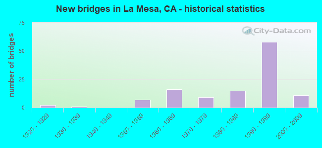
- New bridges - historical statistics
- 21920-1929
- 11930-1939
- 71950-1959
- 161960-1969
- 91970-1979
- 151980-1989
- 581990-1999
- 112000-2009

- Reconstructed bridges - Historical Statistics
- 21950-1959
- 01960-1969
- 01970-1979
- 01980-1989
- 11990-1999
- 12000-2009
- 12010-2019


- Bridge Condition - Deck
- 66.7%Good
- 27.1%Fair
- 6.3%Poor

- Bridge Condition - Superstructure
- 95.8%Good
- 4.2%Fair

- Bridge Condition - Substructure
- 81.3%Good
- 18.8%Fair
Find on map >> Show street view
Structure Number: 57 0309, Location: 11-SD-125-13.80-LMSA (Lat: 32.756125, Lng: -117.008139), Route carried "on" structure: State highway 125, Year Built: 1957, Year Reconstructed: 2002, Status: Open, Structure Length: 5.03m (16.50ft), Average Daily Traffic: 183,000 (year 2018), Truck Traffic: 4%, Average Future Daily Traffic: 273,293 (year 2042), Design Load: HS 20, Features Intersected: PANORAMA DRIVE
Minimum Vertical Clearance: 30+ m (98+ ft), Kilometerpoint: 13.800, Lanes on structure: 8, Lanes under structure: 2, Base Highway Network: Yes (Inventory Route: 1, Subroute: 1), Owner: State Highway Agency, Approaching Roadway Width: 43.0m (141.1ft), Skew: 34 degrees, Material/Design: Steel, Design/Construction: Stringer/Multi-beam, Number Of Spans In Main Unit: 3, Length of Maximum Span: 24.4m (80.1ft), Curb-To-Curb Width: 43.0m (141.1ft), Out-to-Out Width: 44.6m (146.3ft)
Condition: Deck: Poor, Superstructure: Good, Substructure: Good, Operating Rating: 32.4 metric tons, Method Used To Determine Operating Rating: Load and Resistance Factor Rating (LRFR) rating reported by rating factor(RF) method using HL-93 loadings, Inventory Rating: 24.9 metric tons, Method Used To Determine Inventory Rating: Load and Resistance Factor Rating (LRFR) rating reported by rating factor(RF) method using HL-93 loadings, Structural Evaluation: Equal to present minimum criteria, Deck Geometry: Superior to present desirable criteria, Underclear: Somewhat better than minimum adequacy, Approach Roadway Alignment: Equal to present desirable criteria, Length Of Structure Improvement: 5.03m (16.50ft), Designated Inspection Frequency: Every 24 months, Inspection Date: July 2020, Bridge Improvement Cost: $2,250,000, Roadway Improvement Cost: $450,000, Total Project Cost: $3,780,000 ( Estimate for 2021), Deck Structure Type: Concrete Cast-file-Place
Find on map >> Show street view
Structure Number: 57 0311L, Location: 11-SD-125-14.74-LMSA (Lat: 32.768086, Lng: -117.002208), Route carried "on" structure: State highway 125, Year Built: 1990, Status: Open, Structure Length: 3.96m (12.99ft), Average Daily Traffic: 91,500 (year 2018), Truck Traffic: 4%, Average Future Daily Traffic: 133,500 (year 2037), Design Load: HS 20, Features Intersected: LEMON AVE
Minimum Vertical Clearance: 30+ m (98+ ft), Kilometerpoint: 14.740, Lanes on structure: 4, Lanes under structure: 5, Base Highway Network: Yes (Inventory Route: 1, Subroute: 1), Owner: State Highway Agency, Approaching Roadway Width: 27.2m (89.2ft), Material/Design: Prestressed concrete, Design/Construction: Box Beam or Girders - Multiple, Number Of Spans In Main Unit: 1, Length of Maximum Span: 39.0m (128.0ft), Curb-To-Curb Width: 27.2m (89.2ft), Out-to-Out Width: 28.2m (92.5ft)
Condition: Deck: Good, Superstructure: Good, Substructure: Good, Operating Rating: 54.1 metric tons, Method Used To Determine Operating Rating: Assigned rating based on Load Factor Design (LFD) reported in metric tons, Inventory Rating: 32.4 metric tons, Method Used To Determine Inventory Rating: Assigned rating based on Load Factor Design (LFD) reported in metric tons, Structural Evaluation: Better than present minimum criteria, Deck Geometry: Superior to present desirable criteria, Underclear: Meets minimum limits, Approach Roadway Alignment: Equal to present desirable criteria, Designated Inspection Frequency: Every 24 months, Inspection Date: July 2020, Deck Structure Type: Concrete Cast-file-Place
Find on map >> Show street view
Structure Number: 57 0311R, Location: 11-SD-125-14.74-LMSA (Lat: 32.768083, Lng: -117.001858), Route carried "on" structure: State highway 125, Year Built: 1990, Status: Open, Structure Length: 3.96m (12.99ft), Average Daily Traffic: 91,500 (year 2018), Truck Traffic: 4%, Average Future Daily Traffic: 133,500 (year 2037), Design Load: HS 20, Features Intersected: LEMON AVE
Minimum Vertical Clearance: 30+ m (98+ ft), Kilometerpoint: 14.740, Lanes on structure: 5, Lanes under structure: 5, Base Highway Network: Yes (Inventory Route: 1, Subroute: 1), Owner: State Highway Agency, Approaching Roadway Width: 23.6m (77.4ft), Material/Design: Prestressed concrete, Design/Construction: Box Beam or Girders - Multiple, Number Of Spans In Main Unit: 1, Length of Maximum Span: 39.0m (128.0ft), Curb-To-Curb Width: 23.6m (77.4ft), Out-to-Out Width: 24.6m (80.7ft)
Condition: Deck: Good, Superstructure: Good, Substructure: Good, Operating Rating: 54.1 metric tons, Method Used To Determine Operating Rating: Assigned rating based on Load Factor Design (LFD) reported in metric tons, Inventory Rating: 32.4 metric tons, Method Used To Determine Inventory Rating: Assigned rating based on Load Factor Design (LFD) reported in metric tons, Structural Evaluation: Better than present minimum criteria, Deck Geometry: Equal to present minimum criteria, Underclear: Meets minimum limits, Approach Roadway Alignment: Equal to present desirable criteria, Designated Inspection Frequency: Every 24 months, Inspection Date: July 2020, Deck Structure Type: Concrete Cast-file-Place
Find on map >> Show street view
Structure Number: 57 0312L, Location: 11-SD-125-R15.09-LMSA (Lat: 32.773219, Lng: -117.002350), Route carried "on" structure: State highway 125, Year Built: 1990, Status: Open, Structure Length: 3.81m (12.50ft), Average Daily Traffic: 79,500 (year 2010), Average Future Daily Traffic: 103,899 (year 2042), Design Load: HS 20, Features Intersected: GROSSMONT BLVD
Minimum Vertical Clearance: 30+ m (98+ ft), Kilometerpoint: 15.090, Lanes on structure: 5, Lanes under structure: 5, Base Highway Network: Yes (Inventory Route: 1, Subroute: 1), Owner: State Highway Agency, Approaching Roadway Width: 29.7m (97.4ft), Skew: 2 degrees, Material/Design: Prestressed concrete, Design/Construction: Box Beam or Girders - Multiple, Number Of Spans In Main Unit: 1, Length of Maximum Span: 37.5m (123.0ft), Curb-To-Curb Width: 29.7m (97.4ft), Out-to-Out Width: 30.7m (100.7ft)
Condition: Deck: Good, Superstructure: Good, Substructure: Fair, Operating Rating: 54.1 metric tons, Method Used To Determine Operating Rating: Assigned rating based on Load Factor Design (LFD) reported in metric tons, Inventory Rating: 32.4 metric tons, Method Used To Determine Inventory Rating: Assigned rating based on Load Factor Design (LFD) reported in metric tons, Structural Evaluation: Somewhat better than minimum adequacy, Deck Geometry: Superior to present desirable criteria, Underclear: Better than present minimum criteria, Approach Roadway Alignment: Equal to present desirable criteria, Designated Inspection Frequency: Every 24 months, Inspection Date: August 2020, Deck Structure Type: Concrete Cast-file-Place
Find on map >> Show street view
Structure Number: 57 0312R, Location: 11-SD-125-R15.09-LMSA (Lat: 32.773183, Lng: -117.001911), Route carried "on" structure: State highway 125, Year Built: 1990, Status: Open, Structure Length: 3.81m (12.50ft), Average Daily Traffic: 79,500 (year 2010), Average Future Daily Traffic: 103,899 (year 2042), Design Load: HS 20, Features Intersected: GROSSMONT BLVD
Minimum Vertical Clearance: 30+ m (98+ ft), Kilometerpoint: 15.090, Lanes on structure: 6, Lanes under structure: 5, Base Highway Network: Yes (Inventory Route: 1, Subroute: 1), Owner: State Highway Agency, Approaching Roadway Width: 27.4m (89.9ft), Skew: 2 degrees, Material/Design: Prestressed concrete, Design/Construction: Box Beam or Girders - Multiple, Number Of Spans In Main Unit: 1, Length of Maximum Span: 37.5m (123.0ft), Curb-To-Curb Width: 27.4m (89.9ft), Out-to-Out Width: 28.4m (93.2ft)
Condition: Deck: Good, Superstructure: Good, Substructure: Fair, Operating Rating: 54.1 metric tons, Method Used To Determine Operating Rating: Assigned rating based on Load Factor Design (LFD) reported in metric tons, Inventory Rating: 32.4 metric tons, Method Used To Determine Inventory Rating: Assigned rating based on Load Factor Design (LFD) reported in metric tons, Structural Evaluation: Somewhat better than minimum adequacy, Deck Geometry: Equal to present minimum criteria, Underclear: Better than present minimum criteria, Approach Roadway Alignment: Equal to present desirable criteria, Designated Inspection Frequency: Every 24 months, Inspection Date: August 2020, Deck Structure Type: Concrete Cast-file-Place
Find on map >> Show street view
Structure Number: 57 0322, Location: 11-SD-094-9.26-LMGR (Lat: 32.747125, Lng: -117.026633), Route carried "on" structure: City street , Year Built: 1957, Year Reconstructed: 2018, Status: Open, Structure Length: 6.58m (21.59ft), Average Daily Traffic: 2,040 (year 2020), Truck Traffic: 1%, Average Future Daily Traffic: 5,273 (year 2041), Design Load: HS 20, Features Intersected: STATE ROUTE 94, Facility Carried by Structure: GROVE STREET
Minimum Vertical Clearance: 30+ m (98+ ft), Kilometerpoint: 0.000, Lanes on structure: 2, Lanes under structure: 8, Owner: State Highway Agency, Approaching Roadway Width: 10.0m (32.8ft), Skew: 4 degrees, Material/Design: Concrete continuous, Design/Construction: Box Beam or Girders - Multiple, Number Of Spans In Main Unit: 2, Length of Maximum Span: 35.4m (116.1ft), Curb or Sidewalk Widths: Left: 1.8m (5.9ft), Right: 0.0m, Curb-To-Curb Width: 10.0m (32.8ft), Out-to-Out Width: 12.7m (41.7ft)
Condition: Deck: Fair, Superstructure: Good, Substructure: Good, Operating Rating: 82.6 metric tons, Method Used To Determine Operating Rating: Load Factor (LF), Inventory Rating: 48.6 metric tons, Method Used To Determine Inventory Rating: Load Factor (LF), Structural Evaluation: Better than present minimum criteria, Deck Geometry: Meets minimum limits, Underclear: Meets minimum limits, Approach Roadway Alignment: Equal to present desirable criteria, Designated Inspection Frequency: Every 24 months, Inspection Date: January 2021, Deck Structure Type: Concrete Cast-file-Place
Find on map >> Show street view
Structure Number: 57 0327, Location: 11-SD-008-10.61-LMSA (Lat: 32.772942, Lng: -117.029553), Route carried "on" structure: Interstate 8, Year Built: 1939, Year Reconstructed: 1961, Status: Open, Structure Length: 0.98m (3.22ft), Average Daily Traffic: 175,000 (year 2010), Truck Traffic: 4%, Average Future Daily Traffic: 198,000 (year 2037), Features Intersected: ALVARADO CANYON CREEK
Minimum Vertical Clearance: 30+ m (98+ ft), Kilometerpoint: 10.610, Lanes on structure: 9, Base Highway Network: Yes (, Subroute: 1), Owner: State Highway Agency, Approaching Roadway Width: 46.9m (153.9ft), Skew: 33 degrees, Material/Design: Concrete continuous, Design/Construction: Culvert, Number Of Spans In Main Unit: 3, Length of Maximum Span: 2.4m (7.9ft), Curb-To-Curb Width: 47.9m (157.2ft), Out-to-Out Width: 54.6m (179.1ft)
Condition: Channel: Very good, Culverts: Satisfactory, Operating Rating: 40.5 metric tons, Method Used To Determine Operating Rating: Field evaluation and documented engineering judgment, Inventory Rating: 24.3 metric tons, Method Used To Determine Inventory Rating: Field evaluation and documented engineering judgment, Structural Evaluation: Equal to present minimum criteria, Deck Geometry: Superior to present desirable criteria, Waterway Adequacy: Superior to present desirable criteria, Approach Roadway Alignment: Equal to present desirable criteria, Designated Inspection Frequency: Every 24 months, Inspection Date: April 2020
Find on map >> Show street view
Structure Number: 57 0329, Location: 11-SD-008-10.57-LMSA (Lat: 32.773469, Lng: -117.029850), Route carried "on" structure: City street S128, Year Built: 1956, Year Reconstructed: 1961, Status: Open, Structure Length: 8.23m (27.00ft), Average Daily Traffic: 28,323 (year 2011), Truck Traffic: 1%, Average Future Daily Traffic: 29,000 (year 2037), Design Load: HS 20, Features Intersected: INTERSTATE 8, Facility Carried by Structure: FLETCHER PARKWAY
Minimum Vertical Clearance: 30+ m (98+ ft), Kilometerpoint: 0.000, Lanes on structure: 3, Lanes under structure: 9, Base Highway Network: Yes, Owner: State Highway Agency, Approaching Roadway Width: 13.0m (42.7ft), Skew: 3 degrees, Material/Design: Steel, Design/Construction: Stringer/Multi-beam, Number Of Spans In Main Unit: 3, Number Of Approach Spans: 2, Length of Maximum Span: 24.4m (80.1ft), Curb or Sidewalk Widths: Left: 0.5m (1.6ft), Right: 0.5m (1.6ft), Curb-To-Curb Width: 12.7m (41.7ft), Out-to-Out Width: 13.9m (45.6ft)
Condition: Deck: Good, Superstructure: Good, Substructure: Good, Operating Rating: 53.1 metric tons, Method Used To Determine Operating Rating: Load Factor (LF), Inventory Rating: 31.8 metric tons, Method Used To Determine Inventory Rating: Load Factor (LF), Structural Evaluation: Better than present minimum criteria, Deck Geometry: Meets minimum limits, Underclear: Meets minimum limits, Approach Roadway Alignment: Equal to present desirable criteria, Designated Inspection Frequency: Every 24 months, Other Special Inspection Frequency: Every 48 months, Inspection Date: April 2020, Other Special Inspection Date: April 2019, Deck Structure Type: Concrete Cast-file-Place, Wearing Surface/Protective System: Wearing Surface: Monolithic Concrete
Find on map >> Show street view
Structure Number: 57 0342, Location: 11-SD-008-13.04-LMSA (Lat: 32.779394, Lng: -116.990492), Route carried "on" structure: City street , Year Built: 1990, Status: Open, Structure Length: 6.89m (22.60ft), Average Daily Traffic: 19,600 (year 2010), Truck Traffic: 1%, Average Future Daily Traffic: 26,018 (year 2037), Design Load: HS 20+Mod, Features Intersected: INTERSTATE 8, Facility Carried by Structure: GROSSMONT BLVD
Minimum Vertical Clearance: 30+ m (98+ ft), Kilometerpoint: 0.000, Lanes on structure: 2, Lanes under structure: 12, Owner: State Highway Agency, Approaching Roadway Width: 12.2m (40.0ft), Material/Design: Prestressed concrete continuous, Design/Construction: Box Beam or Girders - Multiple, Number Of Spans In Main Unit: 2, Length of Maximum Span: 33.8m (110.9ft), Curb or Sidewalk Widths: Left: 1.5m (4.9ft), Right: 1.5m (4.9ft), Curb-To-Curb Width: 12.2m (40.0ft), Out-to-Out Width: 15.8m (51.8ft)
Condition: Deck: Good, Superstructure: Good, Substructure: Good, Operating Rating: 54.1 metric tons, Method Used To Determine Operating Rating: Assigned rating based on Load Factor Design (LFD) reported in metric tons, Inventory Rating: 32.4 metric tons, Method Used To Determine Inventory Rating: Assigned rating based on Load Factor Design (LFD) reported in metric tons, Structural Evaluation: Better than present minimum criteria, Deck Geometry: Somewhat better than minimum adequacy, Underclear: Meets minimum limits, Approach Roadway Alignment: Equal to present desirable criteria, Designated Inspection Frequency: Every 24 months, Inspection Date: May 2020, Deck Structure Type: Concrete Cast-file-Place
Find on map >> Show street view
Structure Number: 57 0404, Location: 11-SD-008-10.97-LMSA (Lat: 32.771378, Lng: -117.024067), Route carried "on" structure: City street S157, Year Built: 1962, Status: Open, Structure Length: 7.74m (25.39ft), Average Daily Traffic: 39,100 (year 2010), Truck Traffic: 1%, Average Future Daily Traffic: 46,214 (year 2037), Design Load: HS 20, Features Intersected: INTERSTATE 8, Facility Carried by Structure: SPRING ST SB
Minimum Vertical Clearance: 30+ m (98+ ft), Kilometerpoint: 0.000, Lanes on structure: 1, Lanes under structure: 10, Owner: State Highway Agency, Approaching Roadway Width: 6.8m (22.3ft), Skew: 3 degrees, Material/Design: Concrete continuous, Design/Construction: Box Beam or Girders - Multiple, Number Of Spans In Main Unit: 3, Length of Maximum Span: 25.9m (85.0ft), Curb or Sidewalk Widths: Left: 0.6m (2.0ft), Right: 0.6m (2.0ft), Curb-To-Curb Width: 6.8m (22.3ft), Out-to-Out Width: 8.6m (28.2ft)
Condition: Deck: Good, Superstructure: Fair, Substructure: Good, Operating Rating: 48.9 metric tons, Method Used To Determine Operating Rating: Load and Resistance Factor Rating (LRFR) rating reported by rating factor(RF) method using HL-93 loadings, Inventory Rating: 37.9 metric tons, Method Used To Determine Inventory Rating: Load and Resistance Factor Rating (LRFR) rating reported by rating factor(RF) method using HL-93 loadings, Structural Evaluation: Somewhat better than minimum adequacy, Deck Geometry: High priority of replacement, Underclear: Meets minimum limits, Approach Roadway Alignment: Meets minimum limits, Designated Inspection Frequency: Every 24 months, Inspection Date: April 2020, Deck Structure Type: Concrete Cast-file-Place
Find on map >> Show street view
Structure Number: 57 0431, Location: 11-SD-008-11.10-LMSA (Lat: 32.771222, Lng: -117.021264), Route carried "on" structure: Ramp Interstate 8, Year Built: 1962, Status: Open, Structure Length: 11.03m (36.19ft), Average Daily Traffic: 15,800 (year 2010), Truck Traffic: 4%, Average Future Daily Traffic: 16,945 (year 2037), Design Load: HS 20, Features Intersected: INTERSTATE 8
Minimum Vertical Clearance: 30+ m (98+ ft), Kilometerpoint: 11.100, Lanes on structure: 2, Lanes under structure: 8, Base Highway Network: Yes (, Subroute: 1), Owner: State Highway Agency, Approaching Roadway Width: 8.6m (28.2ft), Skew: 5 degrees, Material/Design: Prestressed concrete continuous, Design/Construction: Box Beam or Girders - Multiple, Number Of Spans In Main Unit: 2, Number Of Approach Spans: 2, Length of Maximum Span: 39.6m (129.9ft), Curb or Sidewalk Widths: Left: 0.6m (2.0ft), Right: 0.6m (2.0ft), Curb-To-Curb Width: 8.6m (28.2ft), Out-to-Out Width: 10.4m (34.1ft)
Condition: Deck: Good, Superstructure: Good, Substructure: Good, Operating Rating: 94.9 metric tons, Method Used To Determine Operating Rating: Load Factor (LF), Inventory Rating: 32.4 metric tons, Method Used To Determine Inventory Rating: Load Factor (LF), Structural Evaluation: Better than present minimum criteria, Deck Geometry: Meets minimum limits, Underclear: Somewhat better than minimum adequacy, Approach Roadway Alignment: Equal to present desirable criteria, Designated Inspection Frequency: Every 24 months, Inspection Date: April 2020, Deck Structure Type: Concrete Cast-file-Place
Find on map >> Show street view
Structure Number: 57 0432, Location: 11-SD-008-11.03-LMSA (Lat: 32.771203, Lng: -117.022989), Route carried "on" structure: Ramp City street , Year Built: 1962, Status: Open, Structure Length: 6.52m (21.39ft), Average Daily Traffic: 8,000 (year 2010), Truck Traffic: 1%, Average Future Daily Traffic: 15,405 (year 2037), Design Load: HS 20, Features Intersected: INTERSTATE 8, Facility Carried by Structure: SPRING ST-W8 ONRMP
Minimum Vertical Clearance: 30+ m (98+ ft), Kilometerpoint: 0.000, Lanes on structure: 2, Lanes under structure: 8, Base Highway Network: Yes, Owner: State Highway Agency, Approaching Roadway Width: 8.6m (28.2ft), Skew: 9 degrees, Material/Design: Concrete continuous, Design/Construction: Box Beam or Girders - Multiple, Number Of Spans In Main Unit: 4, Length of Maximum Span: 22.6m (74.1ft), Curb or Sidewalk Widths: Left: 0.6m (2.0ft), Right: 0.6m (2.0ft), Curb-To-Curb Width: 8.6m (28.2ft), Out-to-Out Width: 10.4m (34.1ft)
Condition: Deck: Good, Superstructure: Good, Substructure: Good, Operating Rating: 71.3 metric tons, Method Used To Determine Operating Rating: Load Factor (LF), Inventory Rating: 42.8 metric tons, Method Used To Determine Inventory Rating: Load Factor (LF), Structural Evaluation: Better than present minimum criteria, Deck Geometry: Meets minimum limits, Underclear: Meets minimum limits, Approach Roadway Alignment: Equal to present minimum criteria, Designated Inspection Frequency: Every 48 months, Inspection Date: April 2020, Deck Structure Type: Concrete Cast-file-Place
Find on map >> Show street view
Structure Number: 57 053, Location: 11-SD-005-R40.12 (Lat: 33.029297, Lng: -117.277250), Route carried "on" structure: County highway S342, Year Built: 1964, Status: Open, Structure Length: 15.30m (50.20ft), Average Daily Traffic: 6,860 (year 2020), Truck Traffic: 2%, Average Future Daily Traffic: 10,304 (year 2040), Design Load: HS 20, Features Intersected: INTERSTATE 5, Facility Carried by Structure: MACKINNON AVE
Minimum Vertical Clearance: 30+ m (98+ ft), Kilometerpoint: 0.000, Lanes on structure: 2, Lanes under structure: 8, Owner: State Highway Agency, Approaching Roadway Width: 8.5m (27.9ft), Skew: 6 degrees, Material/Design: Prestressed concrete continuous, Design/Construction: Box Beam or Girders - Multiple, Number Of Spans In Main Unit: 2, Number Of Approach Spans: 2, Length of Maximum Span: 50.6m (166.0ft), Curb or Sidewalk Widths: Left: 1.5m (4.9ft), Right: 1.5m (4.9ft), Curb-To-Curb Width: 8.5m (27.9ft), Out-to-Out Width: 12.2m (40.0ft)
Condition: Deck: Good, Superstructure: Good, Substructure: Good, Operating Rating: 99.8 metric tons, Method Used To Determine Operating Rating: Load Factor (LF), Inventory Rating: 32.4 metric tons, Method Used To Determine Inventory Rating: Load Factor (LF), Structural Evaluation: Better than present minimum criteria, Deck Geometry: Meets minimum limits, Underclear: Meets minimum limits, Approach Roadway Alignment: Equal to present desirable criteria, Designated Inspection Frequency: Every 24 months, Inspection Date: March 2021, Deck Structure Type: Concrete Cast-file-Place
Find on map >> Show street view
Structure Number: 57 0538L, Location: 11-SD-094-R11.08-LMSA (Lat: 32.750400, Lng: -117.001722), Route carried "on" structure: State highway 94, Year Built: 1966, Year Reconstructed: 2000, Status: Open, Structure Length: 3.84m (12.60ft), Average Daily Traffic: 51,000 (year 2019), Truck Traffic: 4%, Average Future Daily Traffic: 61,000 (year 2041), Design Load: HS 20, Features Intersected: BANCROFT DRIVE
Minimum Vertical Clearance: 30+ m (98+ ft), Kilometerpoint: 11.080, Lanes on structure: 3, Lanes under structure: 3, Base Highway Network: Yes (, Subroute: 1), Owner: State Highway Agency, Approaching Roadway Width: 17.1m (56.1ft), Skew: 1 degrees, Material/Design: Concrete continuous, Design/Construction: Box Beam or Girders - Multiple, Number Of Spans In Main Unit: 3, Length of Maximum Span: 19.2m (63.0ft), Curb-To-Curb Width: 17.1m (56.1ft), Out-to-Out Width: 18.1m (59.4ft)
Condition: Deck: Good, Superstructure: Good, Substructure: Good, Operating Rating: 54.0 metric tons, Method Used To Determine Operating Rating: Field evaluation and documented engineering judgment, Inventory Rating: 32.4 metric tons, Method Used To Determine Inventory Rating: Field evaluation and documented engineering judgment, Structural Evaluation: Better than present minimum criteria, Deck Geometry: Equal to present minimum criteria, Underclear: Meets minimum limits, Approach Roadway Alignment: Equal to present desirable criteria, Designated Inspection Frequency: Every 48 months, Inspection Date: January 2021, Deck Structure Type: Concrete Cast-file-Place
Find on map >> Show street view
Structure Number: 57 0538R, Location: 11-SD-094-R11.08-LMSA (Lat: 32.750208, Lng: -117.001542), Route carried "on" structure: State highway 94, Year Built: 1966, Status: Open, Structure Length: 3.84m (12.60ft), Average Daily Traffic: 51,000 (year 2019), Truck Traffic: 5%, Average Future Daily Traffic: 66,311 (year 2041), Design Load: HS 20, Features Intersected: BANCROFT DRIVE
Minimum Vertical Clearance: 30+ m (98+ ft), Kilometerpoint: 11.080, Lanes on structure: 2, Lanes under structure: 3, Base Highway Network: Yes (, Subroute: 1), Owner: State Highway Agency, Approaching Roadway Width: 11.3m (37.1ft), Skew: 1 degrees, Material/Design: Concrete continuous, Design/Construction: Box Beam or Girders - Multiple, Number Of Spans In Main Unit: 3, Length of Maximum Span: 19.2m (63.0ft), Curb-To-Curb Width: 11.3m (37.1ft), Out-to-Out Width: 11.9m (39.0ft)
Condition: Deck: Fair, Superstructure: Good, Substructure: Good, Operating Rating: 35.6 metric tons, Method Used To Determine Operating Rating: Load and Resistance Factor Rating (LRFR) rating reported by rating factor(RF) method using HL-93 loadings, Inventory Rating: 27.5 metric tons, Method Used To Determine Inventory Rating: Load and Resistance Factor Rating (LRFR) rating reported by rating factor(RF) method using HL-93 loadings, Structural Evaluation: Equal to present minimum criteria, Deck Geometry: Somewhat better than minimum adequacy, Underclear: Meets minimum limits, Approach Roadway Alignment: Equal to present desirable criteria, Designated Inspection Frequency: Every 24 months, Inspection Date: January 2021, Deck Structure Type: Concrete Cast-file-Place
Find on map >> Show street view
Structure Number: 57 0790K, Location: 11-SD-805-11.22-NATC (Lat: 32.687292, Lng: -117.093619), Route carried "on" structure: Ramp Interstate 805, Year Built: 1975, Status: Open, Structure Length: 27.43m (89.99ft), Average Daily Traffic: 5,600 (year 2018), Truck Traffic: 1%, Average Future Daily Traffic: 7,189 (year 2040), Design Load: HS 20+Mod, Features Intersected: DIVISION ST & 47TH ST
Minimum Vertical Clearance: 30+ m (98+ ft), Kilometerpoint: 11.220, Lanes on structure: 2, Lanes under structure: 8, Base Highway Network: Yes, Owner: State Highway Agency, Approaching Roadway Width: 12.2m (40.0ft), Skew: 3 degrees, Material/Design: Concrete continuous, Design/Construction: Box Beam or Girders - Multiple, Number Of Spans In Main Unit: 8, Number Of Approach Spans: 1, Length of Maximum Span: 43.2m (141.7ft), Curb-To-Curb Width: 12.2m (40.0ft), Out-to-Out Width: 12.8m (42.0ft)
Condition: Deck: Fair, Superstructure: Good, Substructure: Good, Operating Rating: 86.2 metric tons, Method Used To Determine Operating Rating: Load Factor (LF), Inventory Rating: 32.4 metric tons, Method Used To Determine Inventory Rating: Load Factor (LF), Structural Evaluation: Better than present minimum criteria, Deck Geometry: Superior to present desirable criteria, Underclear: Equal to present minimum criteria, Approach Roadway Alignment: Equal to present desirable criteria, Designated Inspection Frequency: Every 24 months, Inspection Date: July 2020, Deck Structure Type: Concrete Cast-file-Place
Find on map >> Show street view
Structure Number: 57 0798R, Location: 11-SD-094-R10.49R-LMSA (Lat: 32.753503, Lng: -117.009133), Route carried "on" structure: State highway 94, Year Built: 1976, Status: Open, Structure Length: 10.33m (33.89ft), Average Daily Traffic: 73,000 (year 2020), Truck Traffic: 6%, Average Future Daily Traffic: 66,311 (year 2041), Design Load: HS 20, Features Intersected: CAMPO ROAD-N125 ON RAMP
Minimum Vertical Clearance: 30+ m (98+ ft), Kilometerpoint: 10.490, Lanes on structure: 3, Lanes under structure: 3, Base Highway Network: Yes (, Subroute: 1), Owner: State Highway Agency, Approaching Roadway Width: 19.8m (65.0ft), Skew: 9 degrees, Material/Design: Concrete continuous, Design/Construction: Box Beam or Girders - Multiple, Number Of Spans In Main Unit: 4, Length of Maximum Span: 39.6m (129.9ft), Curb-To-Curb Width: 19.8m (65.0ft), Out-to-Out Width: 20.9m (68.6ft)
Condition: Deck: Fair, Superstructure: Good, Substructure: Fair, Operating Rating: 99.8 metric tons, Method Used To Determine Operating Rating: Load Factor (LF), Inventory Rating: 59.3 metric tons, Method Used To Determine Inventory Rating: Load Factor (LF), Structural Evaluation: Somewhat better than minimum adequacy, Deck Geometry: Superior to present desirable criteria, Underclear: Superior to present desirable criteria, Approach Roadway Alignment: Equal to present desirable criteria, Designated Inspection Frequency: Every 24 months, Inspection Date: January 2021, Deck Structure Type: Concrete Cast-file-Place
Find on map >> Show street view
Structure Number: 57 0802K, Location: 11-SD-094-M10.47L-LMSA (Lat: 32.755772, Lng: -117.009147), Route carried "on" structure: Ramp State highway 94, Year Built: 1976, Status: Open, Structure Length: 14.11m (46.29ft), Average Daily Traffic: 3,400 (year 2020), Truck Traffic: 2%, Average Future Daily Traffic: 8,043 (year 2041), Design Load: HS 20+Mod, Features Intersected: STATE ROUTE 125 & RAMPS
Minimum Vertical Clearance: 30+ m (98+ ft), Kilometerpoint: 10.470, Lanes on structure: 1, Lanes under structure: 9, Base Highway Network: Yes (, Subroute: 1), Owner: State Highway Agency, Approaching Roadway Width: 10.4m (34.1ft), Skew: 9 degrees, Material/Design: Prestressed concrete continuous, Design/Construction: Box Beam or Girders - Multiple, Number Of Spans In Main Unit: 3, Length of Maximum Span: 55.2m (181.1ft), Curb-To-Curb Width: 10.4m (34.1ft), Out-to-Out Width: 11.4m (37.4ft)
Condition: Deck: Good, Superstructure: Good, Substructure: Good, Operating Rating: 84.2 metric tons, Method Used To Determine Operating Rating: Load Factor (LF), Inventory Rating: 32.4 metric tons, Method Used To Determine Inventory Rating: Load Factor (LF), Structural Evaluation: Better than present minimum criteria, Deck Geometry: Superior to present desirable criteria, Underclear: Equal to present minimum criteria, Approach Roadway Alignment: Equal to present desirable criteria, Designated Inspection Frequency: Every 24 months, Inspection Date: January 2021, Deck Structure Type: Concrete Cast-file-Place
Find on map >> Show street view
Structure Number: 57 0803, Location: 11-SD-094-R10.72R-LMSA (Lat: 32.752689, Lng: -117.006267), Route carried "on" structure: County highway , Year Built: 1976, Status: Open, Structure Length: 20.06m (65.81ft), Average Daily Traffic: 19,900 (year 2019), Truck Traffic: 2%, Average Future Daily Traffic: 26,810 (year 2041), Design Load: HS 20, Features Intersected: STATE ROUTE 94, Facility Carried by Structure: CAMPO ROAD
Minimum Vertical Clearance: 30+ m (98+ ft), Kilometerpoint: 0.000, Lanes on structure: 2, Lanes under structure: 7, Owner: State Highway Agency, Approaching Roadway Width: 11.9m (39.0ft), Skew: 9 degrees, Material/Design: Prestressed concrete continuous, Design/Construction: Box Beam or Girders - Multiple, Number Of Spans In Main Unit: 5, Length of Maximum Span: 56.1m (184.1ft), Curb or Sidewalk Widths: Left: 0.0m, Right: 1.5m (4.9ft), Curb-To-Curb Width: 12.2m (40.0ft), Out-to-Out Width: 14.6m (47.9ft)
Condition: Deck: Good, Superstructure: Good, Substructure: Good, Operating Rating: 99.8 metric tons, Method Used To Determine Operating Rating: Load Factor (LF), Inventory Rating: 32.4 metric tons, Method Used To Determine Inventory Rating: Load Factor (LF), Structural Evaluation: Better than present minimum criteria, Deck Geometry: Somewhat better than minimum adequacy, Underclear: Equal to present minimum criteria, Approach Roadway Alignment: Equal to present desirable criteria, Designated Inspection Frequency: Every 24 months, Inspection Date: January 2021, Deck Structure Type: Concrete Cast-file-Place
Find on map >> Show street view
Structure Number: 57 0863, Location: 11-SD-008-10.78-LMSA (Lat: 32.772422, Lng: -117.027172), Route carried "on" structure: City street S272, Year Built: 1973, Status: Open, Structure Length: 13.84m (45.41ft), Average Daily Traffic: 26,000 (year 2010), Truck Traffic: 1%, Average Future Daily Traffic: 35,944 (year 2037), Design Load: HS 20, Features Intersected: INTERSTATE 8, Facility Carried by Structure: BALTIMORE DR
Minimum Vertical Clearance: 30+ m (98+ ft), Kilometerpoint: 0.000, Lanes on structure: 4, Lanes under structure: 10, Owner: State Highway Agency, Approaching Roadway Width: 23.6m (77.4ft), Skew: 39 degrees, Material/Design: Prestressed concrete continuous, Design/Construction: Box Beam or Girders - Multiple, Number Of Spans In Main Unit: 3, Length of Maximum Span: 53.3m (174.9ft), Curb or Sidewalk Widths: Left: 1.5m (4.9ft), Right: 1.5m (4.9ft), Curb-To-Curb Width: 17.8m (58.4ft), Out-to-Out Width: 24.2m (79.4ft)
Condition: Deck: Good, Superstructure: Good, Substructure: Good, Operating Rating: 63.5 metric tons, Method Used To Determine Operating Rating: Load and Resistance Factor Rating (LRFR) rating reported by rating factor(RF) method using HL-93 loadings, Inventory Rating: 48.9 metric tons, Method Used To Determine Inventory Rating: Load and Resistance Factor Rating (LRFR) rating reported by rating factor(RF) method using HL-93 loadings, Structural Evaluation: Better than present minimum criteria, Deck Geometry: Somewhat better than minimum adequacy, Underclear: Meets minimum limits, Approach Roadway Alignment: Equal to present desirable criteria, Designated Inspection Frequency: Every 24 months, Inspection Date: April 2020, Deck Structure Type: Concrete Cast-file-Place
Find on map >> Show street view
Structure Number: 57 0950R, Location: 11-SD-125-R15.35-LMSA (Lat: 32.776989, Lng: -117.003189), Route carried "on" structure: State highway 125, Year Built: 1990, Status: Open, Structure Length: 16.49m (54.10ft), Average Daily Traffic: 79,500 (year 2010), Average Future Daily Traffic: 103,899 (year 2042), Design Load: HS 20, Features Intersected: INTERSTATE 8 & RAMPS
Minimum Vertical Clearance: 5.64m (18.50ft), Kilometerpoint: 15.350, Lanes on structure: 4, Lanes under structure: 13, Base Highway Network: Yes (Inventory Route: 1, Subroute: 1), Owner: State Highway Agency, Approaching Roadway Width: 20.2m (66.3ft), Skew: 1 degrees, Material/Design: Prestressed concrete continuous, Design/Construction: Box Beam or Girders - Multiple, Number Of Spans In Main Unit: 4, Length of Maximum Span: 52.1m (170.9ft), Curb-To-Curb Width: 20.2m (66.3ft), Out-to-Out Width: 21.2m (69.6ft)
Condition: Deck: Good, Superstructure: Good, Substructure: Good, Operating Rating: 54.1 metric tons, Method Used To Determine Operating Rating: Assigned rating based on Load Factor Design (LFD) reported in metric tons, Inventory Rating: 32.4 metric tons, Method Used To Determine Inventory Rating: Assigned rating based on Load Factor Design (LFD) reported in metric tons, Structural Evaluation: Better than present minimum criteria, Deck Geometry: Equal to present minimum criteria, Underclear: High priority of corrective action, Approach Roadway Alignment: Equal to present desirable criteria, Designated Inspection Frequency: Every 24 months, Inspection Date: August 2020, Deck Structure Type: Concrete Cast-file-Place
Find on map >> Show street view
Structure Number: 57 0951G, Location: 11-SD-008-11.94-LMSA (Lat: 32.775619, Lng: -117.007906), Route carried "on" structure: Ramp Interstate 8, Year Built: 1990, Status: Open, Structure Length: 48.07m (157.71ft), Average Daily Traffic: 11,100 (year 2010), Truck Traffic: 2%, Average Future Daily Traffic: 12,500 (year 2037), Design Load: HS 20+Mod, Features Intersected: LA MESA BL & S125-GRSMNT
Minimum Vertical Clearance: 30+ m (98+ ft), Kilometerpoint: 11.940, Lanes on structure: 1, Lanes under structure: 1, Base Highway Network: Yes, Owner: State Highway Agency, Approaching Roadway Width: 7.9m (25.9ft), Skew: 9 degrees, Material/Design: Prestressed concrete continuous, Design/Construction: Box Beam or Girders - Multiple, Number Of Spans In Main Unit: 9, Length of Maximum Span: 65.5m (214.9ft), Curb-To-Curb Width: 8.1m (26.6ft), Out-to-Out Width: 9.1m (29.9ft)
Condition: Deck: Good, Superstructure: Good, Substructure: Good, Operating Rating: 54.1 metric tons, Method Used To Determine Operating Rating: Assigned rating based on Load Factor Design (LFD) reported in metric tons, Inventory Rating: 32.4 metric tons, Method Used To Determine Inventory Rating: Assigned rating based on Load Factor Design (LFD) reported in metric tons, Structural Evaluation: Better than present minimum criteria, Deck Geometry: Superior to present desirable criteria, Underclear: Equal to present desirable criteria, Approach Roadway Alignment: Equal to present desirable criteria, Designated Inspection Frequency: Every 24 months, Inspection Date: April 2020, Deck Structure Type: Concrete Cast-file-Place
Find on map >> Show street view
Structure Number: 57 0952F, Location: 11-SD-008-12.32-LMSA (Lat: 32.775525, Lng: -117.003383), Route carried "on" structure: Ramp Interstate 8, Year Built: 1989, Status: Open, Structure Length: 42.49m (139.40ft), Average Daily Traffic: 40,000 (year 2010), Truck Traffic: 5%, Average Future Daily Traffic: 45,000 (year 2037), Design Load: HS 20+Mod, Features Intersected: I 8 & SR 125, & CONNS
Minimum Vertical Clearance: 30+ m (98+ ft), Kilometerpoint: 12.320, Lanes on structure: 3, Lanes under structure: 7, Base Highway Network: Yes (, Subroute: 1), Owner: State Highway Agency, Approaching Roadway Width: 16.0m (52.5ft), Skew: 9 degrees, Material/Design: Prestressed concrete continuous, Design/Construction: Box Beam or Girders - Multiple, Number Of Spans In Main Unit: 9, Length of Maximum Span: 61.6m (202.1ft), Curb-To-Curb Width: 15.5m (50.9ft), Out-to-Out Width: 16.5m (54.1ft)
Condition: Deck: Good, Superstructure: Good, Substructure: Good, Operating Rating: 54.1 metric tons, Method Used To Determine Operating Rating: Assigned rating based on Load Factor Design (LFD) reported in metric tons, Inventory Rating: 32.4 metric tons, Method Used To Determine Inventory Rating: Assigned rating based on Load Factor Design (LFD) reported in metric tons, Structural Evaluation: Better than present minimum criteria, Deck Geometry: Superior to present desirable criteria, Underclear: Equal to present minimum criteria, Approach Roadway Alignment: Equal to present desirable criteria, Designated Inspection Frequency: Every 24 months, Inspection Date: April 2020, Deck Structure Type: Concrete Cast-file-Place
Find on map >> Show street view
Structure Number: 57 0953, Location: 11-SD-008-12.12-LMSA (Lat: 32.777033, Lng: -117.004678), Route carried "on" structure: Interstate 8, Year Built: 1989, Status: Open, Structure Length: 3.75m (12.30ft), Average Daily Traffic: 186,000 (year 2010), Average Future Daily Traffic: 220,000 (year 2037), Design Load: HS 20+Mod, Features Intersected: LA MESA BLVD
Minimum Vertical Clearance: 30+ m (98+ ft), Kilometerpoint: 12.120, Lanes on structure: 8, Lanes under structure: 6, Base Highway Network: Yes (, Subroute: 1), Owner: State Highway Agency, Approaching Roadway Width: 43.0m (141.1ft), Skew: 31 degrees, Material/Design: Prestressed concrete, Design/Construction: Box Beam or Girders - Multiple, Number Of Spans In Main Unit: 1, Length of Maximum Span: 36.3m (119.1ft), Curb-To-Curb Width: 42.9m (140.7ft), Out-to-Out Width: 44.5m (146.0ft)
Condition: Deck: Good, Superstructure: Good, Substructure: Good, Operating Rating: 54.1 metric tons, Method Used To Determine Operating Rating: Assigned rating based on Load Factor Design (LFD) reported in metric tons, Inventory Rating: 32.4 metric tons, Method Used To Determine Inventory Rating: Assigned rating based on Load Factor Design (LFD) reported in metric tons, Structural Evaluation: Better than present minimum criteria, Deck Geometry: Superior to present desirable criteria, Underclear: Meets minimum limits, Approach Roadway Alignment: Equal to present desirable criteria, Designated Inspection Frequency: Every 24 months, Inspection Date: April 2020, Deck Structure Type: Concrete Cast-file-Place
Find on map >> Show street view
Structure Number: 57 0953G, Location: 11-SD-125-R15.43-LMSA (Lat: 32.777414, Lng: -117.004975), Route carried "on" structure: Ramp State highway 125, Year Built: 1989, Status: Open, Structure Length: 11.64m (38.19ft), Average Daily Traffic: 9,700 (year 2010), Truck Traffic: 2%, Average Future Daily Traffic: 16,139 (year 2042), Design Load: HS 20, Features Intersected: LA MESA BL & W8-LA MESA
Minimum Vertical Clearance: 5.76m (18.90ft), Kilometerpoint: 15.430, Lanes on structure: 2, Lanes under structure: 8, Base Highway Network: Yes, Owner: State Highway Agency, Approaching Roadway Width: 11.4m (37.4ft), Material/Design: Prestressed concrete continuous, Design/Construction: Box Beam or Girders - Multiple, Number Of Spans In Main Unit: 2, Length of Maximum Span: 57.6m (189.0ft), Curb-To-Curb Width: 11.4m (37.4ft), Out-to-Out Width: 12.4m (40.7ft)
Condition: Deck: Fair, Superstructure: Good, Substructure: Good, Operating Rating: 54.1 metric tons, Method Used To Determine Operating Rating: Assigned rating based on Load Factor Design (LFD) reported in metric tons, Inventory Rating: 32.4 metric tons, Method Used To Determine Inventory Rating: Assigned rating based on Load Factor Design (LFD) reported in metric tons, Structural Evaluation: Better than present minimum criteria, Deck Geometry: Superior to present desirable criteria, Underclear: Equal to present minimum criteria, Approach Roadway Alignment: Equal to present desirable criteria, Designated Inspection Frequency: Every 24 months, Inspection Date: August 2020, Deck Structure Type: Concrete Cast-file-Place
Find on map >> Show street view
Structure Number: 57 0953S, Location: 11-SD-008-12.12-LMSA (Lat: 32.776897, Lng: -117.004772), Route carried "on" structure: Ramp Interstate 8, Year Built: 1989, Status: Open, Structure Length: 3.72m (12.20ft), Average Daily Traffic: 6,200 (year 2010), Truck Traffic: 1%, Average Future Daily Traffic: 7,702 (year 2037), Design Load: HS 20+Mod, Features Intersected: LA MESA BLVD
Minimum Vertical Clearance: 5.61m (18.41ft), Kilometerpoint: 12.120, Lanes on structure: 1, Lanes under structure: 6, Base Highway Network: Yes (, Subroute: 1), Owner: State Highway Agency, Approaching Roadway Width: 7.3m (24.0ft), Material/Design: Prestressed concrete, Design/Construction: Box Beam or Girders - Multiple, Number Of Spans In Main Unit: 1, Length of Maximum Span: 36.0m (118.1ft), Curb-To-Curb Width: 7.3m (24.0ft), Out-to-Out Width: 8.3m (27.2ft)
Condition: Deck: Good, Superstructure: Good, Substructure: Fair, Operating Rating: 54.1 metric tons, Method Used To Determine Operating Rating: Assigned rating based on Load Factor Design (LFD) reported in metric tons, Inventory Rating: 32.4 metric tons, Method Used To Determine Inventory Rating: Assigned rating based on Load Factor Design (LFD) reported in metric tons, Structural Evaluation: Somewhat better than minimum adequacy, Deck Geometry: Better than present minimum criteria, Underclear: Meets minimum limits, Approach Roadway Alignment: Equal to present desirable criteria, Designated Inspection Frequency: Every 24 months, Inspection Date: April 2020, Deck Structure Type: Concrete Cast-file-Place
Find on map >> Show street view
Structure Number: 57 0954G, Location: 11-SD-125-R15.46-LMSA (Lat: 32.777667, Lng: -117.001947), Route carried "on" structure: Ramp State highway 125, Year Built: 1990, Status: Open, Structure Length: 11.89m (39.01ft), Average Daily Traffic: 30,800 (year 2010), Truck Traffic: 2%, Average Future Daily Traffic: 53,798 (year 2042), Design Load: HS 20, Features Intersected: E8-SEVERIN OFF & LA MESA
Minimum Vertical Clearance: 30+ m (98+ ft), Kilometerpoint: 15.460, Lanes on structure: 3, Lanes under structure: 2, Base Highway Network: Yes, Owner: State Highway Agency, Approaching Roadway Width: 15.5m (50.9ft), Material/Design: Prestressed concrete continuous, Design/Construction: Box Beam or Girders - Multiple, Number Of Spans In Main Unit: 3, Length of Maximum Span: 51.8m (169.9ft), Curb-To-Curb Width: 15.5m (50.9ft), Out-to-Out Width: 16.5m (54.1ft)
Condition: Deck: Good, Superstructure: Good, Substructure: Good, Operating Rating: 54.1 metric tons, Method Used To Determine Operating Rating: Assigned rating based on Load Factor Design (LFD) reported in metric tons, Inventory Rating: 32.4 metric tons, Method Used To Determine Inventory Rating: Assigned rating based on Load Factor Design (LFD) reported in metric tons, Structural Evaluation: Better than present minimum criteria, Deck Geometry: Superior to present desirable criteria, Underclear: Superior to present desirable criteria, Approach Roadway Alignment: Equal to present desirable criteria, Designated Inspection Frequency: Every 24 months, Inspection Date: August 2020, Deck Structure Type: Concrete Cast-file-Place
Find on map >> Show street view
Structure Number: 57 0955, Location: 11-SD-008-12.65-LMSA (Lat: 32.779733, Lng: -116.997258), Route carried "on" structure: City street S151, Year Built: 1989, Status: Open, Structure Length: 8.72m (28.61ft), Average Daily Traffic: 30,400 (year 2010), Truck Traffic: 1%, Average Future Daily Traffic: 41,080 (year 2037), Design Load: HS 20+Mod, Features Intersected: INTERSTATE 8, Facility Carried by Structure: SEVERIN DR
Minimum Vertical Clearance: 30+ m (98+ ft), Kilometerpoint: 0.000, Lanes on structure: 6, Lanes under structure: 14, Owner: State Highway Agency, Approaching Roadway Width: 24.0m (78.7ft), Material/Design: Prestressed concrete continuous, Design/Construction: Box Beam or Girders - Multiple, Number Of Spans In Main Unit: 2, Length of Maximum Span: 43.3m (142.1ft), Curb or Sidewalk Widths: Left: 1.5m (4.9ft), Right: 1.5m (4.9ft), Curb-To-Curb Width: 24.0m (78.7ft), Out-to-Out Width: 27.6m (90.6ft)
Condition: Deck: Good, Superstructure: Good, Substructure: Good, Operating Rating: 54.1 metric tons, Method Used To Determine Operating Rating: Assigned rating based on Load Factor Design (LFD) reported in metric tons, Inventory Rating: 32.4 metric tons, Method Used To Determine Inventory Rating: Assigned rating based on Load Factor Design (LFD) reported in metric tons, Structural Evaluation: Better than present minimum criteria, Deck Geometry: Somewhat better than minimum adequacy, Underclear: Equal to present minimum criteria, Approach Roadway Alignment: Equal to present desirable criteria, Designated Inspection Frequency: Every 24 months, Inspection Date: May 2020, Deck Structure Type: Concrete Cast-file-Place
Find on map >> Show street view
Structure Number: 57 0960G, Location: 11-SD-163-R11.32 (Lat: 32.858514, Lng: -117.112489), Route carried "on" structure: Bypass State highway 163, Year Built: 1986, Status: Open, Structure Length: 18.44m (60.50ft), Average Daily Traffic: 1,000 (year 2011), Truck Traffic: 5%, Average Future Daily Traffic: 2,153 (year 2043), Design Load: HS 20, Features Intersected: N163-N15 CONNECTOR
Minimum Vertical Clearance: 30+ m (98+ ft), Kilometerpoint: 11.320, Lanes on structure: 1, Lanes under structure: 4, Base Highway Network: Yes (Inventory Route: 1, Subroute: 1), Owner: State Highway Agency, Approaching Roadway Width: 7.3m (24.0ft), Material/Design: Prestressed concrete continuous, Design/Construction: Box Beam or Girders - Multiple, Number Of Spans In Main Unit: 4, Length of Maximum Span: 61.3m (201.1ft), Curb-To-Curb Width: 7.3m (24.0ft), Out-to-Out Width: 8.4m (27.6ft)
Condition: Deck: Fair, Superstructure: Good, Substructure: Good, Operating Rating: 99.8 metric tons, Method Used To Determine Operating Rating: Load Factor (LF), Inventory Rating: 32.4 metric tons, Method Used To Determine Inventory Rating: Load Factor (LF), Structural Evaluation: Better than present minimum criteria, Deck Geometry: Meets minimum limits, Underclear: Superior to present desirable criteria, Approach Roadway Alignment: Equal to present desirable criteria, Designated Inspection Frequency: Every 24 months, Inspection Date: January 2021, Deck Structure Type: Concrete Cast-file-Place
Find on map >> Show street view
Structure Number: 57 0969S, Location: 11-SD-125-R15.21-LMSA (Lat: 32.774928, Lng: -117.002178), Route carried "on" structure: Ramp State highway 125, Year Built: 1993, Status: Open, Structure Length: 14.66m (48.10ft), Average Daily Traffic: 2,000 (year 2010), Truck Traffic: 1%, Average Future Daily Traffic: 4,303 (year 2042), Design Load: HS 20, Features Intersected: N125-E8 CONNECTOR RAMP
Minimum Vertical Clearance: 30+ m (98+ ft), Kilometerpoint: 15.210, Lanes on structure: 1, Lanes under structure: 3, Base Highway Network: Yes (Inventory Route: 1, Subroute: 1), Owner: State Highway Agency, Approaching Roadway Width: 7.3m (24.0ft), Material/Design: Prestressed concrete continuous, Design/Construction: Box Beam or Girders - Multiple, Number Of Spans In Main Unit: 3, Length of Maximum Span: 66.8m (219.2ft), Curb-To-Curb Width: 7.3m (24.0ft), Out-to-Out Width: 8.3m (27.2ft)
Condition: Deck: Good, Superstructure: Good, Substructure: Fair, Operating Rating: 54.1 metric tons, Method Used To Determine Operating Rating: Assigned rating based on Load Factor Design (LFD) reported in metric tons, Inventory Rating: 32.4 metric tons, Method Used To Determine Inventory Rating: Assigned rating based on Load Factor Design (LFD) reported in metric tons, Structural Evaluation: Somewhat better than minimum adequacy, Deck Geometry: Better than present minimum criteria, Underclear: Equal to present desirable criteria, Approach Roadway Alignment: Equal to present desirable criteria, Designated Inspection Frequency: Every 24 months, Inspection Date: August 2020, Deck Structure Type: Concrete Cast-file-Place, Wearing Surface/Protective System: Wearing Surface: Integral Concrete
Find on map >> Show street view
Structure Number: 57 0971F, Location: 11-SD-125-R15.56-LMSA (Lat: 32.779733, Lng: -117.004811), Route carried "on" structure: Ramp State highway 125, Year Built: 1993, Status: Open, Structure Length: 4.08m (13.39ft), Average Daily Traffic: 2,001 (year 2010), Truck Traffic: 4%, Average Future Daily Traffic: 4,303 (year 2042), Design Load: HS 20, Features Intersected: MURRAY DRIVE
Minimum Vertical Clearance: 30+ m (98+ ft), Kilometerpoint: 15.560, Lanes on structure: 2, Lanes under structure: 4, Base Highway Network: Yes, Owner: State Highway Agency, Approaching Roadway Width: 13.9m (45.6ft), Material/Design: Prestressed concrete, Design/Construction: Box Beam or Girders - Multiple, Number Of Spans In Main Unit: 1, Length of Maximum Span: 39.9m (130.9ft), Curb-To-Curb Width: 13.9m (45.6ft), Out-to-Out Width: 14.9m (48.9ft)
Condition: Deck: Fair, Superstructure: Good, Substructure: Good, Operating Rating: 54.1 metric tons, Method Used To Determine Operating Rating: Assigned rating based on Load Factor Design (LFD) reported in metric tons, Inventory Rating: 32.4 metric tons, Method Used To Determine Inventory Rating: Assigned rating based on Load Factor Design (LFD) reported in metric tons, Structural Evaluation: Better than present minimum criteria, Deck Geometry: Superior to present desirable criteria, Underclear: Meets minimum limits, Approach Roadway Alignment: Equal to present desirable criteria, Designated Inspection Frequency: Every 24 months, Inspection Date: August 2020, Deck Structure Type: Concrete Cast-file-Place
Find on map >> Show street view
Structure Number: 57 0971L, Location: 11-SD-125-R15.56-LMSA (Lat: 32.779794, Lng: -117.004436), Route carried "on" structure: State highway 125, Year Built: 1993, Status: Open, Structure Length: 4.18m (13.71ft), Average Daily Traffic: 43,000 (year 2010), Truck Traffic: 4%, Average Future Daily Traffic: 43,126 (year 2042), Design Load: HS 20, Features Intersected: MURRAY DRIVE
Minimum Vertical Clearance: 30+ m (98+ ft), Kilometerpoint: 15.560, Lanes on structure: 3, Lanes under structure: 4, Base Highway Network: Yes (Inventory Route: 1, Subroute: 1), Owner: State Highway Agency, Approaching Roadway Width: 20.3m (66.6ft), Material/Design: Prestressed concrete, Design/Construction: Box Beam or Girders - Multiple, Number Of Spans In Main Unit: 1, Length of Maximum Span: 40.8m (133.9ft), Curb-To-Curb Width: 20.3m (66.6ft), Out-to-Out Width: 21.3m (69.9ft)
Condition: Deck: Fair, Superstructure: Good, Substructure: Fair, Operating Rating: 54.1 metric tons, Method Used To Determine Operating Rating: Assigned rating based on Load Factor Design (LFD) reported in metric tons, Inventory Rating: 32.4 metric tons, Method Used To Determine Inventory Rating: Assigned rating based on Load Factor Design (LFD) reported in metric tons, Structural Evaluation: Somewhat better than minimum adequacy, Deck Geometry: Superior to present desirable criteria, Underclear: Meets minimum limits, Approach Roadway Alignment: Equal to present desirable criteria, Designated Inspection Frequency: Every 24 months, Inspection Date: August 2020, Deck Structure Type: Concrete Cast-file-Place
Find on map >> Show street view
Structure Number: 57 0971R, Location: 11-SD-125-R15.56-LMSA (Lat: 32.779861, Lng: -117.004150), Route carried "on" structure: State highway 125, Year Built: 1990, Status: Open, Structure Length: 3.93m (12.89ft), Average Daily Traffic: 43,000 (year 2010), Truck Traffic: 4%, Average Future Daily Traffic: 43,126 (year 2042), Design Load: HS 20, Features Intersected: MURRAY DRIVE
Minimum Vertical Clearance: 30+ m (98+ ft), Kilometerpoint: 15.560, Lanes on structure: 3, Lanes under structure: 4, Base Highway Network: Yes (Inventory Route: 1, Subroute: 1), Owner: State Highway Agency, Approaching Roadway Width: 16.3m (53.5ft), Material/Design: Prestressed concrete, Design/Construction: Box Beam or Girders - Multiple, Number Of Spans In Main Unit: 1, Length of Maximum Span: 38.7m (127.0ft), Curb-To-Curb Width: 16.3m (53.5ft), Out-to-Out Width: 17.3m (56.8ft)
Condition: Deck: Fair, Superstructure: Good, Substructure: Good, Operating Rating: 54.1 metric tons, Method Used To Determine Operating Rating: Assigned rating based on Load Factor Design (LFD) reported in metric tons, Inventory Rating: 32.4 metric tons, Method Used To Determine Inventory Rating: Assigned rating based on Load Factor Design (LFD) reported in metric tons, Structural Evaluation: Better than present minimum criteria, Deck Geometry: Equal to present minimum criteria, Underclear: Meets minimum limits, Approach Roadway Alignment: Equal to present desirable criteria, Designated Inspection Frequency: Every 24 months, Inspection Date: August 2020, Deck Structure Type: Concrete Cast-file-Place
Find on map >> Show street view
Structure Number: 57 0972L, Location: 11-SD-125-18.42-LMSA (Lat: 32.783431, Lng: -117.005567), Route carried "on" structure: State highway 125, Year Built: 2001, Status: Open, Structure Length: 20.70m (67.91ft), Average Daily Traffic: 19,500 (year 2010), Truck Traffic: 1%, Average Future Daily Traffic: 32,279 (year 2042), Design Load: HS 20, Features Intersected: FLETCHER PKWY & LRT
Minimum Vertical Clearance: 30+ m (98+ ft), Kilometerpoint: 18.420, Lanes on structure: 4, Lanes under structure: 8, Base Highway Network: Yes (Inventory Route: 1, Subroute: 1), Owner: State Highway Agency, Approaching Roadway Width: 24.4m (80.1ft), Skew: 39 degrees, Material/Design: Prestressed concrete continuous, Design/Construction: Box Beam or Girders - Multiple, Number Of Spans In Main Unit: 4, Length of Maximum Span: 58.5m (191.9ft), Curb-To-Curb Width: 24.4m (80.1ft), Out-to-Out Width: 25.4m (83.3ft)
Condition: Deck: Good, Superstructure: Good, Substructure: Good, Operating Rating: 54.1 metric tons, Method Used To Determine Operating Rating: Assigned rating based on Load Factor Design (LFD) reported in metric tons, Inventory Rating: 32.4 metric tons, Method Used To Determine Inventory Rating: Assigned rating based on Load Factor Design (LFD) reported in metric tons, Structural Evaluation: Better than present minimum criteria, Deck Geometry: Superior to present desirable criteria, Underclear: Somewhat better than minimum adequacy, Approach Roadway Alignment: Equal to present desirable criteria, Designated Inspection Frequency: Every 24 months, Inspection Date: August 2020, Deck Structure Type: Concrete Cast-file-Place
Find on map >> Show street view
Structure Number: 57 0972R, Location: 11-SD-125-18.42-LMSA (Lat: 32.783639, Lng: -117.005244), Route carried "on" structure: State highway 125, Year Built: 1993, Status: Open, Structure Length: 19.96m (65.49ft), Average Daily Traffic: 19,500 (year 2010), Truck Traffic: 1%, Average Future Daily Traffic: 32,279 (year 2042), Design Load: HS 20, Features Intersected: FLETCHER PKWY & LRT
Minimum Vertical Clearance: 30+ m (98+ ft), Kilometerpoint: 18.420, Lanes on structure: 5, Lanes under structure: 8, Base Highway Network: Yes (Inventory Route: 1, Subroute: 1), Owner: State Highway Agency, Approaching Roadway Width: 23.8m (78.1ft), Skew: 1 degrees, Material/Design: Prestressed concrete continuous, Design/Construction: Box Beam or Girders - Multiple, Number Of Spans In Main Unit: 4, Length of Maximum Span: 61.6m (202.1ft), Curb-To-Curb Width: 23.8m (78.1ft), Out-to-Out Width: 24.8m (81.4ft)
Condition: Deck: Fair, Superstructure: Good, Substructure: Good, Operating Rating: 54.1 metric tons, Method Used To Determine Operating Rating: Assigned rating based on Load Factor Design (LFD) reported in metric tons, Inventory Rating: 32.4 metric tons, Method Used To Determine Inventory Rating: Assigned rating based on Load Factor Design (LFD) reported in metric tons, Structural Evaluation: Better than present minimum criteria, Deck Geometry: Equal to present minimum criteria, Underclear: Somewhat better than minimum adequacy, Approach Roadway Alignment: Equal to present desirable criteria, Designated Inspection Frequency: Every 24 months, Inspection Date: August 2020, Deck Structure Type: Concrete Cast-file-Place
Find on map >> Show street view
Structure Number: 57 0973G, Location: 11-SD-008-11.96-LMSA (Lat: 32.776208, Lng: -117.006200), Route carried "on" structure: Ramp Interstate 8, Year Built: 1993, Status: Open, Structure Length: 43.13m (141.50ft), Average Daily Traffic: 8,100 (year 2010), Truck Traffic: 4%, Average Future Daily Traffic: 12,324 (year 2037), Design Load: HS 20+Mod, Features Intersected: I 8 & SR 125, & CONNS
Minimum Vertical Clearance: 30+ m (98+ ft), Kilometerpoint: 11.960, Lanes on structure: 2, Lanes under structure: 17, Base Highway Network: Yes, Owner: State Highway Agency, Approaching Roadway Width: 11.8m (38.7ft), Skew: 9 degrees, Material/Design: Prestressed concrete continuous, Design/Construction: Box Beam or Girders - Multiple, Number Of Spans In Main Unit: 8, Length of Maximum Span: 73.2m (240.2ft), Curb-To-Curb Width: 11.8m (38.7ft), Out-to-Out Width: 12.8m (42.0ft)
Condition: Deck: Good, Superstructure: Good, Substructure: Good, Operating Rating: 54.1 metric tons, Method Used To Determine Operating Rating: Assigned rating based on Load Factor Design (LFD) reported in metric tons, Inventory Rating: 32.4 metric tons, Method Used To Determine Inventory Rating: Assigned rating based on Load Factor Design (LFD) reported in metric tons, Structural Evaluation: Better than present minimum criteria, Deck Geometry: Superior to present desirable criteria, Underclear: Meets minimum limits, Approach Roadway Alignment: Equal to present desirable criteria, Designated Inspection Frequency: Every 24 months, Inspection Date: April 2020, Deck Structure Type: Concrete Cast-file-Place
Find on map >> Show street view
Structure Number: 57 0974F, Location: 11-SD-008-12.40-LMSA (Lat: 32.779256, Lng: -117.003106), Route carried "on" structure: Ramp Interstate 8, Year Built: 1992, Status: Open, Structure Length: 12.71m (41.70ft), Average Daily Traffic: 12,200 (year 2010), Truck Traffic: 2%, Average Future Daily Traffic: 15,000 (year 2037), Design Load: HS 20+Mod, Features Intersected: N125-W8 & SEVERIN DR-W8
Minimum Vertical Clearance: 30+ m (98+ ft), Kilometerpoint: 12.400, Lanes on structure: 1, Lanes under structure: 2, Base Highway Network: Yes (, Subroute: 1), Owner: State Highway Agency, Approaching Roadway Width: 7.9m (25.9ft), Skew: 9 degrees, Material/Design: Prestressed concrete continuous, Design/Construction: Box Beam or Girders - Multiple, Number Of Spans In Main Unit: 4, Length of Maximum Span: 39.6m (129.9ft), Curb-To-Curb Width: 8.1m (26.6ft), Out-to-Out Width: 9.1m (29.9ft)
Condition: Deck: Good, Superstructure: Good, Substructure: Good, Operating Rating: 54.1 metric tons, Method Used To Determine Operating Rating: Assigned rating based on Load Factor Design (LFD) reported in metric tons, Inventory Rating: 32.4 metric tons, Method Used To Determine Inventory Rating: Assigned rating based on Load Factor Design (LFD) reported in metric tons, Structural Evaluation: Better than present minimum criteria, Deck Geometry: Superior to present desirable criteria, Underclear: Superior to present desirable criteria, Approach Roadway Alignment: Equal to present desirable criteria, Designated Inspection Frequency: Every 24 months, Inspection Date: April 2020, Deck Structure Type: Concrete Cast-file-Place
Find on map >> Show street view
Structure Number: 57 0975F, Location: 11-SD-125-R15.47-LMSA (Lat: 32.777839, Lng: -117.005567), Route carried "on" structure: Ramp State highway 125, Year Built: 1993, Status: Open, Structure Length: 4.75m (15.58ft), Average Daily Traffic: 5,700 (year 2010), Truck Traffic: 2%, Average Future Daily Traffic: 10,760 (year 2042), Design Load: HS 20, Features Intersected: GROSSMONT CENTER DRIVE
Minimum Vertical Clearance: 30+ m (98+ ft), Kilometerpoint: 15.470, Lanes on structure: 2, Lanes under structure: 4, Base Highway Network: Yes, Owner: State Highway Agency, Approaching Roadway Width: 10.6m (34.8ft), Skew: 1 degrees, Material/Design: Prestressed concrete, Design/Construction: Box Beam or Girders - Multiple, Number Of Spans In Main Unit: 1, Length of Maximum Span: 46.9m (153.9ft), Curb-To-Curb Width: 10.6m (34.8ft), Out-to-Out Width: 11.6m (38.1ft)
Condition: Deck: Good, Superstructure: Good, Substructure: Good, Operating Rating: 54.1 metric tons, Method Used To Determine Operating Rating: Assigned rating based on Load Factor Design (LFD) reported in metric tons, Inventory Rating: 32.4 metric tons, Method Used To Determine Inventory Rating: Assigned rating based on Load Factor Design (LFD) reported in metric tons, Structural Evaluation: Better than present minimum criteria, Deck Geometry: Better than present minimum criteria, Underclear: Meets minimum limits, Approach Roadway Alignment: Equal to present desirable criteria, Designated Inspection Frequency: Every 24 months, Inspection Date: August 2020, Deck Structure Type: Concrete Cast-file-Place
Find on map >> Show street view
Structure Number: 57 0985, Location: 11-SD-125-18.33-LMSA (Lat: 32.782214, Lng: -117.005533), Route carried "on" structure: City street , Year Built: 1992, Status: Open, Structure Length: 8.26m (27.10ft), Average Daily Traffic: 3,240 (year 2010), Truck Traffic: 1%, Average Future Daily Traffic: 5,379 (year 2042), Design Load: HS 20, Features Intersected: ROUTE 125, Facility Carried by Structure: WAKARUSA STREET
Minimum Vertical Clearance: 30+ m (98+ ft), Kilometerpoint: 0.000, Lanes on structure: 2, Lanes under structure: 9, Owner: State Highway Agency, Approaching Roadway Width: 9.8m (32.2ft), Skew: 22 degrees, Material/Design: Prestressed concrete continuous, Design/Construction: Box Beam or Girders - Multiple, Number Of Spans In Main Unit: 2, Length of Maximum Span: 41.8m (137.1ft), Curb or Sidewalk Widths: Left: 1.5m (4.9ft), Right: 1.5m (4.9ft), Curb-To-Curb Width: 9.8m (32.2ft), Out-to-Out Width: 13.4m (44.0ft)
Condition: Deck: Fair, Superstructure: Good, Substructure: Fair, Operating Rating: 54.1 metric tons, Method Used To Determine Operating Rating: Assigned rating based on Load Factor Design (LFD) reported in metric tons, Inventory Rating: 32.4 metric tons, Method Used To Determine Inventory Rating: Assigned rating based on Load Factor Design (LFD) reported in metric tons, Structural Evaluation: Somewhat better than minimum adequacy, Deck Geometry: Meets minimum limits, Underclear: Meets minimum limits, Approach Roadway Alignment: Equal to present desirable criteria, Designated Inspection Frequency: Every 24 months, Inspection Date: August 2020, Deck Structure Type: Concrete Cast-file-Place
Find on map >> Show street view
Structure Number: 57 0988H, Location: 11-SD-008-12.30-LMSA (Lat: 32.780231, Lng: -117.004122), Route carried "on" structure: Ramp Interstate 8, Year Built: 1992, Status: Open, Structure Length: 9.78m (32.09ft), Average Daily Traffic: 23,300 (year 2010), Truck Traffic: 2%, Average Future Daily Traffic: 24,500 (year 2037), Design Load: HS 20+Mod, Features Intersected: N125-W8 CONN & MURRAY DR
Minimum Vertical Clearance: 30+ m (98+ ft), Kilometerpoint: 12.300, Lanes on structure: 3, Lanes under structure: 5, Base Highway Network: Yes (, Subroute: 1), Owner: State Highway Agency, Approaching Roadway Width: 18.0m (59.1ft), Skew: 9 degrees, Material/Design: Prestressed concrete continuous, Design/Construction: Box Beam or Girders - Multiple, Number Of Spans In Main Unit: 2, Length of Maximum Span: 48.8m (160.1ft), Curb-To-Curb Width: 17.6m (57.7ft), Out-to-Out Width: 18.6m (61.0ft)
Condition: Deck: Good, Superstructure: Good, Substructure: Good, Operating Rating: 54.1 metric tons, Method Used To Determine Operating Rating: Assigned rating based on Load Factor Design (LFD) reported in metric tons, Inventory Rating: 32.4 metric tons, Method Used To Determine Inventory Rating: Assigned rating based on Load Factor Design (LFD) reported in metric tons, Structural Evaluation: Better than present minimum criteria, Deck Geometry: Superior to present desirable criteria, Underclear: Somewhat better than minimum adequacy, Approach Roadway Alignment: Equal to present desirable criteria, Designated Inspection Frequency: Every 24 months, Inspection Date: April 2020, Deck Structure Type: Concrete Cast-file-Place
Find on map >> Show street view
Structure Number: 57 1044, Location: 11-SD-125-18.66-LMSA (Lat: 32.787028, Lng: -117.006869), Route carried "on" structure: City street , Year Built: 2001, Status: Open, Structure Length: 11.09m (36.38ft), Average Daily Traffic: 14,300 (year 2010), Truck Traffic: 1%, Average Future Daily Traffic: 21,519 (year 2042), Design Load: HS 20, Features Intersected: STATE ROUTE 125, Facility Carried by Structure: AMAYA DRIVE
Minimum Vertical Clearance: 30+ m (98+ ft), Kilometerpoint: 0.000, Lanes on structure: 3, Lanes under structure: 10, Owner: State Highway Agency, Approaching Roadway Width: 21.2m (69.6ft), Skew: 32 degrees, Material/Design: Prestressed concrete continuous, Design/Construction: Box Beam or Girders - Multiple, Number Of Spans In Main Unit: 2, Length of Maximum Span: 58.4m (191.6ft), Curb-To-Curb Width: 19.1m (62.7ft), Out-to-Out Width: 21.2m (69.6ft)
Condition: Deck: Good, Superstructure: Good, Substructure: Good, Operating Rating: 54.1 metric tons, Method Used To Determine Operating Rating: Assigned rating based on Load Factor Design (LFD) reported in metric tons, Inventory Rating: 32.4 metric tons, Method Used To Determine Inventory Rating: Assigned rating based on Load Factor Design (LFD) reported in metric tons, Structural Evaluation: Better than present minimum criteria, Deck Geometry: Superior to present desirable criteria, Underclear: Better than present minimum criteria, Approach Roadway Alignment: Equal to present desirable criteria, Designated Inspection Frequency: Every 24 months, Inspection Date: August 2020, Deck Structure Type: Concrete Cast-file-Place