Bridge Statistics for Troy, Ohio (OH)
Condition, Traffic, Stress, Structural Evaluation, Project Costs
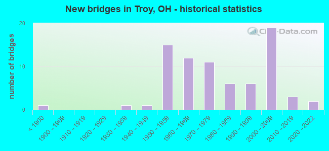
- New bridges - historical statistics
- 1Before 1900
- 11930-1939
- 11940-1949
- 151950-1959
- 121960-1969
- 111970-1979
- 61980-1989
- 61990-1999
- 192000-2009
- 32010-2019
- 22020-2022

- Reconstructed bridges - Historical Statistics
- 11970-1979
- 31980-1989
- 71990-1999
- 12000-2009


- Bridge Condition - Deck
- 19.0%Excellent
- 24.1%Very good
- 34.5%Good
- 17.2%Satisfactory
- 5.2%Poor

- Bridge Condition - Superstructure
- 20.7%Excellent
- 34.5%Very good
- 27.6%Good
- 8.6%Satisfactory
- 5.2%Fair
- 3.4%Poor

- Bridge Condition - Substructure
- 19.0%Excellent
- 22.4%Very good
- 39.7%Good
- 12.1%Satisfactory
- 3.4%Fair
- 3.4%Poor

- Bridge Condition - Channel
- 21.0%Excellent
- 25.8%Very good
- 29.0%Good
- 24.2%Satisfactory

- Bridge Condition - Culverts
- 8.3%Excellent
- 16.7%Very good
- 33.3%Good
- 41.7%Satisfactory
Find on map >> Show street view
Structure Number: 550132, Location: JUST WEST OF CR 17 (Lat: 39.203711, Lng: -82.116650), Route carried "on" structure: County highway C0069, Year Built: 1935, Status: Posted for load, Structure Length: 0.67m (2.20ft), Average Daily Traffic: 209 (year 2015), Truck Traffic: 7%, Average Future Daily Traffic: 290 (year 2035), Design Load: HS 20, Features Intersected: TRIB TO SHADE RIVER, Facility Carried by Structure: CHASE RD
Minimum Vertical Clearance: 30+ m (98+ ft), Kilometerpoint: 6.228, Lanes on structure: 1, Owner: County Highway Agency, Approaching Roadway Width: 6.1m (20.0ft), Skew: 3 degrees, Material/Design: Concrete, Design/Construction: Slab, Number Of Spans In Main Unit: 1, Length of Maximum Span: 6.4m (21.0ft), Curb-To-Curb Width: 4.6m (15.1ft), Out-to-Out Width: 5.2m (17.1ft)
Condition: Deck: Satisfactory, Superstructure: Satisfactory, Substructure: Satisfactory, Channel: Satisfactory, Operating Rating: 13.1 metric tons, Method Used To Determine Operating Rating: Field evaluation and documented engineering judgment, Inventory Rating: 9.2 metric tons, Method Used To Determine Inventory Rating: Field evaluation and documented engineering judgment, Structural Evaluation: High priority of replacement, Deck Geometry: High priority of replacement, Waterway Adequacy: Better than present minimum criteria, Approach Roadway Alignment: Meets minimum limits, Bridge Posting: Required (Relationship of Operating Rating to Maximum Legal Load: > 39.9% below), Length Of Structure Improvement: 0.76m (2.49ft), Designated Inspection Frequency: Every 12 months, Inspection Date: October 2021, Bridge Improvement Cost: $35,000, Roadway Improvement Cost: $4,000, Total Project Cost: $42,000, Deck Structure Type: Concrete Cast-file-Place
Find on map >> Show street view
Structure Number: 5500613, Location: 1.34 MI.E. OF SR.201 (Lat: 40.020311, Lng: -84.154131), Route carried "on" structure: State highway 41, Year Built: 2002, Status: Open, Structure Length: 6.24m (20.47ft), Average Daily Traffic: 3,413 (year 2015), Truck Traffic: 3%, Average Future Daily Traffic: 4,737 (year 2035), Design Load: HS 20+Mod, Features Intersected: LOST CREEK
Minimum Vertical Clearance: 30+ m (98+ ft), Kilometerpoint: 10.364, Lanes on structure: 2, Owner: State Highway Agency, Approaching Roadway Width: 7.3m (24.0ft), Skew: 2 degrees, Material/Design: Steel continuous, Design/Construction: Stringer/Multi-beam, Number Of Spans In Main Unit: 3, Length of Maximum Span: 23.5m (77.1ft), Curb-To-Curb Width: 13.4m (44.0ft), Out-to-Out Width: 13.4m (44.0ft)
Condition: Deck: Good, Superstructure: Very good, Substructure: Very good, Channel: Excellent, Operating Rating: 42.1 metric tons, Method Used To Determine Operating Rating: Load Factor (LF) rating reported by rating factor (RF) method using MS18 loading, Inventory Rating: 32.4 metric tons, Method Used To Determine Inventory Rating: Load Factor (LF) rating reported by rating factor (RF) method using MS18 loading, Structural Evaluation: Equal to present desirable criteria, Deck Geometry: Better than present minimum criteria, Waterway Adequacy: Equal to present desirable criteria, Approach Roadway Alignment: Equal to present minimum criteria, Designated Inspection Frequency: Every 24 months, Inspection Date: March 2021, Deck Structure Type: Concrete Cast-file-Place, Wearing Surface/Protective System: Wearing Surface: Monolithic Concrete, Deck Protection: Epoxy Coated Reinforcing
Find on map >> Show street view
Structure Number: 5500699, Location: .58M W.OF SR202 (Lat: 40.030019, Lng: -84.185769), Route carried "on" structure: State highway 41, Year Built: 1960, Status: Open, Structure Length: 23.10m (75.79ft), Average Daily Traffic: 6,525 (year 2018), Truck Traffic: 4%, Average Future Daily Traffic: 9,057 (year 2038), Design Load: H 20, Features Intersected: GREAT MIAMI RIVER
Minimum Vertical Clearance: 30+ m (98+ ft), Kilometerpoint: 13.406, Lanes on structure: 2, Owner: State Highway Agency, Approaching Roadway Width: 13.1m (43.0ft), Skew: 5 degrees, Material/Design: Steel continuous, Design/Construction: Stringer/Multi-beam, Number Of Spans In Main Unit: 9, Length of Maximum Span: 26.5m (86.9ft), Curb or Sidewalk Widths: Left: 0.9m (3.0ft), Right: 0.9m (3.0ft), Curb-To-Curb Width: 9.1m (29.9ft), Out-to-Out Width: 11.7m (38.4ft)
Condition: Deck: Satisfactory, Superstructure: Good, Substructure: Good, Channel: Satisfactory, Operating Rating: 32.4 metric tons, Method Used To Determine Operating Rating: Load Factor (LF) rating reported by rating factor (RF) method using MS18 loading, Inventory Rating: 25.9 metric tons, Method Used To Determine Inventory Rating: Load Factor (LF) rating reported by rating factor (RF) method using MS18 loading, Structural Evaluation: Equal to present minimum criteria, Deck Geometry: Meets minimum limits, Waterway Adequacy: Superior to present desirable criteria, Approach Roadway Alignment: Equal to present desirable criteria, Designated Inspection Frequency: Every 12 months, Inspection Date: May 2021, Deck Structure Type: Concrete Cast-file-Place, Wearing Surface/Protective System: Wearing Surface: Integral Concrete
Find on map >> Show street view
Structure Number: 5500753, Location: JCT. IR-75 (Lat: 40.052050, Lng: -84.231869), Route carried "on" structure: State highway 41, Year Built: 1957, Year Reconstructed: 1977, Status: Open, Structure Length: 8.56m (28.08ft), Average Daily Traffic: 28,958 (year 2015), Truck Traffic: 6%, Average Future Daily Traffic: 40,194 (year 2035), Design Load: HL 93, Features Intersected: IR 75
Minimum Vertical Clearance: 30+ m (98+ ft), Kilometerpoint: 18.089, Lanes on structure: 4, Lanes under structure: 4, Owner: State Highway Agency, Approaching Roadway Width: 20.7m (67.9ft), Skew: 3 degrees, Material/Design: Steel continuous, Design/Construction: Stringer/Multi-beam, Number Of Spans In Main Unit: 4, Length of Maximum Span: 27.4m (89.9ft), Curb or Sidewalk Widths: Left: 1.5m (4.9ft), Right: 1.5m (4.9ft), Curb-To-Curb Width: 24.4m (80.1ft), Out-to-Out Width: 25.0m (82.0ft)
Condition: Deck: Satisfactory, Superstructure: Good, Substructure: Satisfactory, Operating Rating: 22.7 metric tons, Method Used To Determine Operating Rating: Load and Resistance Factor Rating (LRFR) rating reported by rating factor(RF) method using HL-93 loadings, Inventory Rating: 16.2 metric tons, Method Used To Determine Inventory Rating: Load and Resistance Factor Rating (LRFR) rating reported by rating factor(RF) method using HL-93 loadings, Structural Evaluation: Meets minimum limits, Deck Geometry: Superior to present desirable criteria, Underclear: Equal to present minimum criteria, Approach Roadway Alignment: Equal to present desirable criteria, Designated Inspection Frequency: Every 12 months, Inspection Date: March 2021, Deck Structure Type: Concrete Cast-file-Place, Wearing Surface/Protective System: Wearing Surface: Integral Concrete
Find on map >> Show street view
Structure Number: 5501326, Location: .9MI.W. OF JCT. IR-75 (Lat: 40.019211, Lng: -84.246469), Route carried "on" structure: State highway 55, Year Built: 1968, Status: Open, Structure Length: 2.07m (6.79ft), Average Daily Traffic: 6,881 (year 2015), Truck Traffic: 3%, Average Future Daily Traffic: 9,551 (year 2035), Design Load: H 15, Features Intersected: WEST BR.OF PETERS CREEK
Minimum Vertical Clearance: 30+ m (98+ ft), Kilometerpoint: 14.355, Lanes on structure: 2, Owner: State Highway Agency, Approaching Roadway Width: 13.1m (43.0ft), Skew: 2 degrees, Material/Design: Concrete continuous, Design/Construction: Slab, Number Of Spans In Main Unit: 3, Length of Maximum Span: 7.6m (24.9ft), Curb-To-Curb Width: 13.4m (44.0ft), Out-to-Out Width: 13.4m (44.0ft)
Condition: Deck: Good, Superstructure: Good, Substructure: Good, Channel: Very good, Operating Rating: 45.4 metric tons, Method Used To Determine Operating Rating: Load Factor (LF) rating reported by rating factor (RF) method using MS18 loading, Inventory Rating: 25.9 metric tons, Method Used To Determine Inventory Rating: Load Factor (LF) rating reported by rating factor (RF) method using MS18 loading, Structural Evaluation: Equal to present minimum criteria, Deck Geometry: Equal to present minimum criteria, Waterway Adequacy: Better than present minimum criteria, Approach Roadway Alignment: Better than present minimum criteria, Designated Inspection Frequency: Every 24 months, Inspection Date: March 2021, Deck Structure Type: Concrete Cast-file-Place, Wearing Surface/Protective System: Wearing Surface: Bituminous, Membrane: Preformed Fabric
Find on map >> Show street view
Structure Number: 550135, Location: JCT. IR-75 (Lat: 40.025150, Lng: -84.231239), Route carried "on" structure: State highway 55, Year Built: 1968, Year Reconstructed: 2002, Status: Open, Structure Length: 7.56m (24.80ft), Average Daily Traffic: 8,933 (year 2015), Truck Traffic: 4%, Average Future Daily Traffic: 12,399 (year 2035), Design Load: HS 20+Mod, Features Intersected: IR 75
Minimum Vertical Clearance: 30+ m (98+ ft), Kilometerpoint: 15.804, Lanes on structure: 2, Lanes under structure: 6, Owner: State Highway Agency, Approaching Roadway Width: 16.0m (52.5ft), Skew: 2 degrees, Material/Design: Steel continuous, Design/Construction: Stringer/Multi-beam, Number Of Spans In Main Unit: 4, Length of Maximum Span: 23.2m (76.1ft), Curb-To-Curb Width: 16.0m (52.5ft), Out-to-Out Width: 16.9m (55.4ft)
Condition: Deck: Satisfactory, Superstructure: Very good, Substructure: Satisfactory, Operating Rating: 42.1 metric tons, Method Used To Determine Operating Rating: Load Factor (LF) rating reported by rating factor (RF) method using MS18 loading, Inventory Rating: 32.4 metric tons, Method Used To Determine Inventory Rating: Load Factor (LF) rating reported by rating factor (RF) method using MS18 loading, Structural Evaluation: Equal to present minimum criteria, Deck Geometry: Superior to present desirable criteria, Underclear: Equal to present minimum criteria, Approach Roadway Alignment: Equal to present desirable criteria, Designated Inspection Frequency: Every 12 months, Inspection Date: March 2021, Deck Structure Type: Concrete Cast-file-Place, Wearing Surface/Protective System: Wearing Surface: Monolithic Concrete, Deck Protection: Epoxy Coated Reinforcing
Find on map >> Show street view
Structure Number: 5501385, Location: JCT.IR-75 (Lat: 40.024969, Lng: -84.231231), Route carried "on" structure: State highway 55, Year Built: 1957, Year Reconstructed: 2002, Status: Open, Structure Length: 7.45m (24.44ft), Average Daily Traffic: 8,933 (year 2015), Truck Traffic: 4%, Average Future Daily Traffic: 12,399 (year 2035), Design Load: HS 20+Mod, Features Intersected: IR 75
Minimum Vertical Clearance: 30+ m (98+ ft), Kilometerpoint: 15.804, Lanes on structure: 2, Lanes under structure: 4, Owner: State Highway Agency, Approaching Roadway Width: 16.0m (52.5ft), Skew: 2 degrees, Material/Design: Steel continuous, Design/Construction: Stringer/Multi-beam, Number Of Spans In Main Unit: 4, Length of Maximum Span: 22.9m (75.1ft), Curb-To-Curb Width: 16.0m (52.5ft), Out-to-Out Width: 16.9m (55.4ft)
Condition: Deck: Satisfactory, Superstructure: Very good, Substructure: Good, Operating Rating: 42.1 metric tons, Method Used To Determine Operating Rating: Load Factor (LF) rating reported by rating factor (RF) method using MS18 loading, Inventory Rating: 32.4 metric tons, Method Used To Determine Inventory Rating: Load Factor (LF) rating reported by rating factor (RF) method using MS18 loading, Structural Evaluation: Better than present minimum criteria, Deck Geometry: Superior to present desirable criteria, Underclear: Equal to present minimum criteria, Approach Roadway Alignment: Equal to present desirable criteria, Designated Inspection Frequency: Every 12 months, Inspection Date: March 2021, Deck Structure Type: Concrete Cast-file-Place, Wearing Surface/Protective System: Wearing Surface: Monolithic Concrete, Deck Protection: Epoxy Coated Reinforcing
Find on map >> Show street view
Structure Number: 5501415, Location: .27MI.E. OF JCT. IR-75 (Lat: 40.026889, Lng: -84.226769), Route carried "on" structure: State highway 55, Year Built: 1968, Status: Open, Structure Length: 3.66m (12.01ft), Average Daily Traffic: 5,088 (year 2015), Truck Traffic: 4%, Average Future Daily Traffic: 7,062 (year 2035), Design Load: H 20, Features Intersected: PETERS CREEK
Minimum Vertical Clearance: 30+ m (98+ ft), Kilometerpoint: 16.238, Lanes on structure: 2, Owner: State Highway Agency, Approaching Roadway Width: 11.9m (39.0ft), Skew: 2 degrees, Material/Design: Concrete continuous, Design/Construction: Slab, Number Of Spans In Main Unit: 3, Length of Maximum Span: 13.7m (44.9ft), Curb-To-Curb Width: 12.2m (40.0ft), Out-to-Out Width: 12.2m (40.0ft)
Condition: Deck: Good, Superstructure: Good, Substructure: Good, Channel: Very good, Operating Rating: 55.1 metric tons, Method Used To Determine Operating Rating: Load Factor (LF) rating reported by rating factor (RF) method using MS18 loading, Inventory Rating: 32.4 metric tons, Method Used To Determine Inventory Rating: Load Factor (LF) rating reported by rating factor (RF) method using MS18 loading, Structural Evaluation: Better than present minimum criteria, Deck Geometry: Better than present minimum criteria, Waterway Adequacy: Equal to present desirable criteria, Approach Roadway Alignment: Better than present minimum criteria, Designated Inspection Frequency: Every 24 months, Inspection Date: March 2021, Deck Structure Type: Concrete Cast-file-Place, Wearing Surface/Protective System: Wearing Surface: Bituminous
Find on map >> Show street view
Structure Number: 5501474, Location: .27MI.E. OF JCT. IR-75 (Lat: 40.026769, Lng: -84.226581), Route carried "on" structure: State highway 55, Year Built: 1968, Status: Open, Structure Length: 3.66m (12.01ft), Average Daily Traffic: 5,088 (year 2015), Truck Traffic: 4%, Average Future Daily Traffic: 7,062 (year 2035), Design Load: H 20, Features Intersected: PETERS CREEK
Minimum Vertical Clearance: 30+ m (98+ ft), Kilometerpoint: 16.238, Lanes on structure: 2, Owner: State Highway Agency, Approaching Roadway Width: 11.9m (39.0ft), Skew: 2 degrees, Material/Design: Concrete continuous, Design/Construction: Slab, Number Of Spans In Main Unit: 3, Length of Maximum Span: 13.7m (44.9ft), Curb-To-Curb Width: 12.2m (40.0ft), Out-to-Out Width: 12.2m (40.0ft)
Condition: Deck: Good, Superstructure: Good, Substructure: Good, Channel: Very good, Operating Rating: 55.1 metric tons, Method Used To Determine Operating Rating: Load Factor (LF) rating reported by rating factor (RF) method using MS18 loading, Inventory Rating: 32.4 metric tons, Method Used To Determine Inventory Rating: Load Factor (LF) rating reported by rating factor (RF) method using MS18 loading, Structural Evaluation: Better than present minimum criteria, Deck Geometry: Better than present minimum criteria, Waterway Adequacy: Equal to present desirable criteria, Approach Roadway Alignment: Better than present minimum criteria, Designated Inspection Frequency: Every 24 months, Inspection Date: March 2021, Deck Structure Type: Concrete Cast-file-Place, Wearing Surface/Protective System: Wearing Surface: Bituminous
Find on map >> Show street view
Structure Number: 5501504, Location: .1MI.N. OF JCT. SR-41 (Lat: 40.041100, Lng: -84.202139), Route carried "on" structure: State highway 55, Year Built: 1961, Status: Open, Structure Length: 15.12m (49.61ft), Average Daily Traffic: 14,392 (year 2015), Truck Traffic: 3%, Average Future Daily Traffic: 19,976 (year 2035), Design Load: H 20, Features Intersected: GREAT MIAMI RIVER
Minimum Vertical Clearance: 30+ m (98+ ft), Kilometerpoint: 19.039, Lanes on structure: 4, Owner: State Highway Agency, Approaching Roadway Width: 15.9m (52.2ft), Skew: 1 degrees, Material/Design: Steel continuous, Design/Construction: Stringer/Multi-beam, Number Of Spans In Main Unit: 6, Length of Maximum Span: 26.8m (87.9ft), Curb or Sidewalk Widths: Left: 1.8m (5.9ft), Right: 1.8m (5.9ft), Curb-To-Curb Width: 15.9m (52.2ft), Out-to-Out Width: 20.2m (66.3ft)
Condition: Deck: Satisfactory, Superstructure: Good, Substructure: Good, Channel: Very good, Operating Rating: 38.9 metric tons, Method Used To Determine Operating Rating: Load and Resistance Factor Rating (LRFR) rating reported by rating factor(RF) method using HL-93 loadings, Inventory Rating: 29.2 metric tons, Method Used To Determine Inventory Rating: Load and Resistance Factor Rating (LRFR) rating reported by rating factor(RF) method using HL-93 loadings, Structural Evaluation: Better than present minimum criteria, Deck Geometry: Meets minimum limits, Waterway Adequacy: Equal to present desirable criteria, Approach Roadway Alignment: Better than present minimum criteria, Designated Inspection Frequency: Every 12 months, Inspection Date: March 2021, Deck Structure Type: Concrete Cast-file-Place, Wearing Surface/Protective System: Wearing Surface: Latex Concrete
Find on map >> Show street view
Structure Number: 5501547, Location: .35MI.E. OF JCT. SR-202 (Lat: 40.042419, Lng: -84.176181), Route carried "on" structure: State highway 55, Year Built: 1982, Status: Open, Structure Length: 0.91m (2.99ft), Average Daily Traffic: 5,407 (year 2015), Truck Traffic: 2%, Average Future Daily Traffic: 7,505 (year 2035), Design Load: HS 20, Features Intersected: TRIB TO MIAMI RIVER
Minimum Vertical Clearance: 30+ m (98+ ft), Kilometerpoint: 21.517, Lanes on structure: 2, Owner: State Highway Agency, Approaching Roadway Width: 12.2m (40.0ft), Skew: 1 degrees, Material/Design: Concrete, Design/Construction: Culvert, Number Of Spans In Main Unit: 2, Length of Maximum Span: 3.7m (12.1ft)
Condition: Channel: Good, Culverts: Satisfactory, Operating Rating: 42.1 metric tons, Method Used To Determine Operating Rating: Load Factor (LF) rating reported by rating factor (RF) method using MS18 loading, Inventory Rating: 32.4 metric tons, Method Used To Determine Inventory Rating: Load Factor (LF) rating reported by rating factor (RF) method using MS18 loading, Structural Evaluation: Equal to present minimum criteria, Waterway Adequacy: Equal to present desirable criteria, Approach Roadway Alignment: Equal to present desirable criteria, Designated Inspection Frequency: Every 12 months, Inspection Date: March 2021
Find on map >> Show street view
Structure Number: 5501954, Location: 1.62MI.S. OF JCT. SR-55 (Lat: 40.002600, Lng: -84.224500), Route carried "on" structure: Interstate 75, Year Built: 1957, Year Reconstructed: 2002, Status: Open, Structure Length: 2.07m (6.79ft), Average Daily Traffic: 33,420 (year 2015), Truck Traffic: 12%, Average Future Daily Traffic: 46,387 (year 2035), Design Load: HS 20+Mod, Features Intersected: STANLEY RENCH DITCH
Minimum Vertical Clearance: 30+ m (98+ ft), Kilometerpoint: 10.026, Lanes on structure: 3, Base Highway Network: Yes, Owner: State Highway Agency, Approaching Roadway Width: 21.2m (69.6ft), Skew: 2 degrees, Material/Design: Concrete continuous, Design/Construction: Slab, Number Of Spans In Main Unit: 3, Length of Maximum Span: 7.6m (24.9ft), Curb-To-Curb Width: 20.2m (66.3ft), Out-to-Out Width: 21.2m (69.6ft)
Condition: Deck: Very good, Superstructure: Very good, Substructure: Good, Channel: Very good, Operating Rating: 64.8 metric tons, Method Used To Determine Operating Rating: Load Factor (LF) rating reported by rating factor (RF) method using MS18 loading, Inventory Rating: 38.9 metric tons, Method Used To Determine Inventory Rating: Load Factor (LF) rating reported by rating factor (RF) method using MS18 loading, Structural Evaluation: Better than present minimum criteria, Deck Geometry: Superior to present desirable criteria, Waterway Adequacy: Superior to present desirable criteria, Approach Roadway Alignment: Better than present minimum criteria, Designated Inspection Frequency: Every 24 months, Inspection Date: March 2021, Deck Structure Type: Concrete Cast-file-Place, Wearing Surface/Protective System: Wearing Surface: Monolithic Concrete, Deck Protection: Epoxy Coated Reinforcing
Find on map >> Show street view
Structure Number: 5501989, Location: 1.62MI.S. OF JCT. SR-55 (Lat: 40.002750, Lng: -84.224419), Route carried "on" structure: Interstate 75, Year Built: 1957, Year Reconstructed: 2002, Status: Open, Structure Length: 2.07m (6.79ft), Average Daily Traffic: 33,420 (year 2015), Truck Traffic: 12%, Average Future Daily Traffic: 46,387 (year 2035), Design Load: HS 20+Mod, Features Intersected: STANLEY RENCH DITCH
Minimum Vertical Clearance: 30+ m (98+ ft), Kilometerpoint: 10.026, Lanes on structure: 3, Base Highway Network: Yes, Owner: State Highway Agency, Approaching Roadway Width: 20.2m (66.3ft), Skew: 2 degrees, Material/Design: Concrete continuous, Design/Construction: Slab, Number Of Spans In Main Unit: 3, Length of Maximum Span: 7.6m (24.9ft), Curb-To-Curb Width: 20.2m (66.3ft), Out-to-Out Width: 21.2m (69.6ft)
Condition: Deck: Very good, Superstructure: Very good, Substructure: Good, Channel: Very good, Operating Rating: 64.8 metric tons, Method Used To Determine Operating Rating: Load Factor (LF) rating reported by rating factor (RF) method using MS18 loading, Inventory Rating: 38.9 metric tons, Method Used To Determine Inventory Rating: Load Factor (LF) rating reported by rating factor (RF) method using MS18 loading, Structural Evaluation: Better than present minimum criteria, Deck Geometry: Superior to present desirable criteria, Waterway Adequacy: Superior to present desirable criteria, Approach Roadway Alignment: Better than present minimum criteria, Designated Inspection Frequency: Every 24 months, Inspection Date: March 2021, Deck Structure Type: Concrete Cast-file-Place, Wearing Surface/Protective System: Wearing Surface: Monolithic Concrete, Deck Protection: Epoxy Coated Reinforcing
Find on map >> Show street view
Structure Number: 550202, Location: 1.39 MILES S OF JCT 55 (Lat: 40.005561, Lng: -84.227319), Route carried "on" structure: Interstate 75, Year Built: 2001, Status: Open, Structure Length: 4.02m (13.19ft), Average Daily Traffic: 66,840 (year 2015), Truck Traffic: 12%, Average Future Daily Traffic: 92,774 (year 2035), Design Load: HS 20, Features Intersected: EXT OF BOONE CREEK
Minimum Vertical Clearance: 30+ m (98+ ft), Kilometerpoint: 10.396, Lanes on structure: 6, Base Highway Network: Yes, Owner: State Highway Agency, Approaching Roadway Width: 70.9m (232.6ft), Skew: 3 degrees, Material/Design: Concrete, Design/Construction: Culvert, Number Of Spans In Main Unit: 2, Length of Maximum Span: 9.8m (32.2ft)
Condition: Channel: Good, Culverts: Very good, Operating Rating: 42.1 metric tons, Method Used To Determine Operating Rating: Load Factor (LF) rating reported by rating factor (RF) method using MS18 loading, Inventory Rating: 32.4 metric tons, Method Used To Determine Inventory Rating: Load Factor (LF) rating reported by rating factor (RF) method using MS18 loading, Structural Evaluation: Equal to present desirable criteria, Waterway Adequacy: Superior to present desirable criteria, Approach Roadway Alignment: Meets minimum limits, Designated Inspection Frequency: Every 24 months, Inspection Date: March 2021
Find on map >> Show street view
Structure Number: 5502055, Location: 2.41MI N.OF 25A RAMP (Lat: 40.010119, Lng: -84.230081), Route carried "on" structure: County highway CR137, Year Built: 2002, Status: Open, Structure Length: 5.69m (18.67ft), Average Daily Traffic: 2,307 (year 2015), Truck Traffic: 5%, Average Future Daily Traffic: 92,774 (year 2035), Design Load: HS 20+Mod, Features Intersected: I-75, Facility Carried by Structure: SWAILES ROAD
Minimum Vertical Clearance: 30+ m (98+ ft), Kilometerpoint: 2.414, Lanes on structure: 2, Lanes under structure: 6, Owner: State Highway Agency, Approaching Roadway Width: 13.4m (44.0ft), Skew: 1 degrees, Material/Design: Prestressed concrete continuous, Design/Construction: Stringer/Multi-beam, Number Of Spans In Main Unit: 2, Length of Maximum Span: 27.8m (91.2ft), Curb-To-Curb Width: 13.4m (44.0ft), Out-to-Out Width: 14.3m (46.9ft)
Condition: Deck: Good, Superstructure: Very good, Substructure: Good, Operating Rating: 64.8 metric tons, Method Used To Determine Operating Rating: Load and Resistance Factor Rating (LRFR) rating reported by rating factor(RF) method using HL-93 loadings, Inventory Rating: 38.9 metric tons, Method Used To Determine Inventory Rating: Load and Resistance Factor Rating (LRFR) rating reported by rating factor(RF) method using HL-93 loadings, Structural Evaluation: Better than present minimum criteria, Deck Geometry: Better than present minimum criteria, Underclear: Equal to present minimum criteria, Approach Roadway Alignment: Meets minimum limits, Designated Inspection Frequency: Every 24 months, Inspection Date: March 2021, Deck Structure Type: Concrete Cast-file-Place, Wearing Surface/Protective System: Wearing Surface: Monolithic Concrete, Deck Protection: Epoxy Coated Reinforcing
Find on map >> Show street view
Structure Number: 5502071, Location: .71MI.S. OF JCT. SR-55 (Lat: 40.014711, Lng: -84.230300), Route carried "on" structure: Interstate 75, Year Built: 1957, Status: Open, Structure Length: 0.98m (3.22ft), Average Daily Traffic: 66,840 (year 2015), Truck Traffic: 12%, Average Future Daily Traffic: 92,774 (year 2035), Design Load: HS 20, Features Intersected: CLAYTON EXT. OF PETERS C
Minimum Vertical Clearance: 30+ m (98+ ft), Kilometerpoint: 11.491, Lanes on structure: 4, Base Highway Network: Yes, Owner: State Highway Agency, Approaching Roadway Width: 39.0m (128.0ft), Skew: 1 degrees, Material/Design: Steel, Design/Construction: Culvert, Number Of Spans In Main Unit: 4, Length of Maximum Span: 1.8m (5.9ft)
Condition: Channel: Good, Culverts: Good, Operating Rating: 42.1 metric tons, Method Used To Determine Operating Rating: Load Factor (LF) rating reported by rating factor (RF) method using MS18 loading, Inventory Rating: 32.4 metric tons, Method Used To Determine Inventory Rating: Load Factor (LF) rating reported by rating factor (RF) method using MS18 loading, Structural Evaluation: Better than present minimum criteria, Waterway Adequacy: Superior to present desirable criteria, Approach Roadway Alignment: Superior to present desirable criteria, Designated Inspection Frequency: Every 24 months, Inspection Date: April 2021
Find on map >> Show street view
Structure Number: 5502101, Location: .57MI.S. OF JCT. SR-55 (Lat: 40.016931, Lng: -84.230411), Route carried "on" structure: Interstate 75, Year Built: 1957, Status: Open, Structure Length: 0.64m (2.10ft), Average Daily Traffic: 66,840 (year 2015), Truck Traffic: 12%, Average Future Daily Traffic: 92,774 (year 2035), Design Load: HS 20, Features Intersected: W. BRANCH OF PETERS CREE
Minimum Vertical Clearance: 30+ m (98+ ft), Kilometerpoint: 11.716, Lanes on structure: 4, Base Highway Network: Yes, Owner: State Highway Agency, Approaching Roadway Width: 39.0m (128.0ft), Material/Design: Steel, Design/Construction: Culvert, Number Of Spans In Main Unit: 2, Length of Maximum Span: 2.7m (8.9ft)
Condition: Channel: Good, Culverts: Good, Operating Rating: 97.2 metric tons, Method Used To Determine Operating Rating: Load Factor (LF) rating reported by rating factor (RF) method using MS18 loading, Inventory Rating: 68.0 metric tons, Method Used To Determine Inventory Rating: Load Factor (LF) rating reported by rating factor (RF) method using MS18 loading, Structural Evaluation: Better than present minimum criteria, Waterway Adequacy: Superior to present desirable criteria, Approach Roadway Alignment: Superior to present desirable criteria, Designated Inspection Frequency: Every 24 months, Inspection Date: April 2021
Find on map >> Show street view
Structure Number: 5502225, Location: RAMP SB I-75 TO SR-55 (Lat: 40.026000, Lng: -84.232200), Route carried "on" structure: Ramp Interstate 75, Year Built: 1968, Year Reconstructed: 2002, Status: Open, Structure Length: 3.65m (11.98ft), Average Daily Traffic: 23,630 (year 1975), Average Future Daily Traffic: 32,798 (year 1995), Design Load: HS 20+Mod, Features Intersected: RAMP C OVER PETERS CREEK
Minimum Vertical Clearance: 30+ m (98+ ft), Kilometerpoint: 12.762, Lanes on structure: 1, Owner: State Highway Agency, Approaching Roadway Width: 11.6m (38.1ft), Skew: 3 degrees, Material/Design: Concrete continuous, Design/Construction: Slab, Number Of Spans In Main Unit: 3, Length of Maximum Span: 13.7m (44.9ft), Curb-To-Curb Width: 11.6m (38.1ft), Out-to-Out Width: 12.5m (41.0ft)
Condition: Deck: Good, Superstructure: Good, Substructure: Satisfactory, Channel: Very good, Operating Rating: 42.1 metric tons, Method Used To Determine Operating Rating: Load Factor (LF) rating reported by rating factor (RF) method using MS18 loading, Inventory Rating: 32.4 metric tons, Method Used To Determine Inventory Rating: Load Factor (LF) rating reported by rating factor (RF) method using MS18 loading, Structural Evaluation: Equal to present minimum criteria, Deck Geometry: Superior to present desirable criteria, Waterway Adequacy: Superior to present desirable criteria, Approach Roadway Alignment: Better than present minimum criteria, Designated Inspection Frequency: Every 12 months, Inspection Date: March 2021, Deck Structure Type: Concrete Cast-file-Place, Wearing Surface/Protective System: Wearing Surface: Monolithic Concrete, Deck Protection: Epoxy Coated Reinforcing
Find on map >> Show street view
Structure Number: 5502284, Location: 7.93 MI. N. OF MOT.CO. LN (Lat: 40.026239, Lng: -84.231011), Route carried "on" structure: Interstate 75, Year Built: 1957, Year Reconstructed: 2002, Status: Open, Structure Length: 3.01m (9.88ft), Average Daily Traffic: 31,637 (year 2015), Truck Traffic: 12%, Average Future Daily Traffic: 43,912 (year 2035), Design Load: HS 20+Mod, Features Intersected: PETERS CREEK
Minimum Vertical Clearance: 30+ m (98+ ft), Kilometerpoint: 12.762, Lanes on structure: 3, Base Highway Network: Yes, Owner: State Highway Agency, Approaching Roadway Width: 20.2m (66.3ft), Skew: 1 degrees, Material/Design: Concrete continuous, Design/Construction: Slab, Number Of Spans In Main Unit: 3, Length of Maximum Span: 11.4m (37.4ft), Curb-To-Curb Width: 20.2m (66.3ft), Out-to-Out Width: 21.2m (69.6ft)
Condition: Deck: Very good, Superstructure: Very good, Substructure: Good, Channel: Very good, Operating Rating: 71.3 metric tons, Method Used To Determine Operating Rating: Load Factor (LF) rating reported by rating factor (RF) method using MS18 loading, Inventory Rating: 42.1 metric tons, Method Used To Determine Inventory Rating: Load Factor (LF) rating reported by rating factor (RF) method using MS18 loading, Structural Evaluation: Better than present minimum criteria, Deck Geometry: Superior to present desirable criteria, Waterway Adequacy: Superior to present desirable criteria, Approach Roadway Alignment: Better than present minimum criteria, Designated Inspection Frequency: Every 24 months, Inspection Date: March 2021, Deck Structure Type: Concrete Cast-file-Place, Wearing Surface/Protective System: Wearing Surface: Monolithic Concrete, Deck Protection: Epoxy Coated Reinforcing
Find on map >> Show street view
Structure Number: 5502314, Location: 7.93 MI.N. OF MOT. CO. LN (Lat: 40.026289, Lng: -84.230800), Route carried "on" structure: Interstate 75, Year Built: 1957, Year Reconstructed: 2002, Status: Open, Structure Length: 3.01m (9.88ft), Average Daily Traffic: 31,637 (year 2015), Truck Traffic: 12%, Average Future Daily Traffic: 43,912 (year 2035), Design Load: HS 20+Mod, Features Intersected: PETERS CREEK
Minimum Vertical Clearance: 30+ m (98+ ft), Kilometerpoint: 12.762, Lanes on structure: 3, Base Highway Network: Yes, Owner: State Highway Agency, Approaching Roadway Width: 20.2m (66.3ft), Skew: 1 degrees, Material/Design: Concrete continuous, Design/Construction: Slab, Number Of Spans In Main Unit: 3, Length of Maximum Span: 11.4m (37.4ft), Curb-To-Curb Width: 20.2m (66.3ft), Out-to-Out Width: 21.2m (69.6ft)
Condition: Deck: Good, Superstructure: Good, Substructure: Good, Channel: Good, Operating Rating: 71.3 metric tons, Method Used To Determine Operating Rating: Load Factor (LF) rating reported by rating factor (RF) method using MS18 loading, Inventory Rating: 42.1 metric tons, Method Used To Determine Inventory Rating: Load Factor (LF) rating reported by rating factor (RF) method using MS18 loading, Structural Evaluation: Better than present minimum criteria, Deck Geometry: Superior to present desirable criteria, Waterway Adequacy: Superior to present desirable criteria, Approach Roadway Alignment: Better than present minimum criteria, Designated Inspection Frequency: Every 24 months, Inspection Date: March 2021, Deck Structure Type: Concrete Cast-file-Place, Wearing Surface/Protective System: Wearing Surface: Monolithic Concrete, Deck Protection: Epoxy Coated Reinforcing
Find on map >> Show street view
Structure Number: 5502357, Location: RAMP SR-55 TO NB 75 (Lat: 40.026600, Lng: -84.230050), Route carried "on" structure: Ramp Interstate 75, Year Built: 2002, Status: Open, Structure Length: 3.61m (11.84ft), Average Daily Traffic: 4,042 (year 1998), Truck Traffic: 5%, Average Future Daily Traffic: 5,610 (year 2018), Design Load: HS 20+Mod, Features Intersected: PETER'S CREEK
Minimum Vertical Clearance: 30+ m (98+ ft), Kilometerpoint: 12.762, Lanes on structure: 1, Owner: State Highway Agency, Approaching Roadway Width: 7.6m (24.9ft), Skew: 2 degrees, Material/Design: Concrete continuous, Design/Construction: Slab, Number Of Spans In Main Unit: 3, Length of Maximum Span: 13.7m (44.9ft), Curb-To-Curb Width: 9.1m (29.9ft), Out-to-Out Width: 10.1m (33.1ft)
Condition: Deck: Very good, Superstructure: Very good, Substructure: Very good, Channel: Excellent, Operating Rating: 38.9 metric tons, Method Used To Determine Operating Rating: Load and Resistance Factor Rating (LRFR) rating reported by rating factor(RF) method using HL-93 loadings, Inventory Rating: 29.2 metric tons, Method Used To Determine Inventory Rating: Load and Resistance Factor Rating (LRFR) rating reported by rating factor(RF) method using HL-93 loadings, Structural Evaluation: Better than present minimum criteria, Deck Geometry: Superior to present desirable criteria, Waterway Adequacy: Superior to present desirable criteria, Approach Roadway Alignment: Equal to present desirable criteria, Designated Inspection Frequency: Every 24 months, Inspection Date: March 2021, Deck Structure Type: Concrete Cast-file-Place, Wearing Surface/Protective System: Wearing Surface: Monolithic Concrete, Deck Protection: Epoxy Coated Reinforcing
Find on map >> Show street view
Structure Number: 5502438, Location: 1.0 MI N OF SR 55 (Lat: 40.039581, Lng: -84.231900), Route carried "on" structure: County highway C0133, Year Built: 2000, Status: Open, Structure Length: 5.61m (18.41ft), Average Daily Traffic: 4,978 (year 2015), Truck Traffic: 1%, Average Future Daily Traffic: 87,823 (year 2035), Design Load: HS 20+Mod, Features Intersected: I-75, Facility Carried by Structure: MCKAIG ROAD
Minimum Vertical Clearance: 30+ m (98+ ft), Kilometerpoint: 24.623, Lanes on structure: 2, Lanes under structure: 6, Owner: State Highway Agency, Approaching Roadway Width: 7.3m (24.0ft), Material/Design: Prestressed concrete continuous, Design/Construction: Stringer/Multi-beam, Number Of Spans In Main Unit: 2, Length of Maximum Span: 27.6m (90.6ft), Curb-To-Curb Width: 13.4m (44.0ft), Out-to-Out Width: 14.3m (46.9ft)
Condition: Deck: Good, Superstructure: Good, Substructure: Good, Operating Rating: 55.1 metric tons, Method Used To Determine Operating Rating: Load and Resistance Factor Rating (LRFR) rating reported by rating factor(RF) method using HL-93 loadings, Inventory Rating: 42.1 metric tons, Method Used To Determine Inventory Rating: Load and Resistance Factor Rating (LRFR) rating reported by rating factor(RF) method using HL-93 loadings, Structural Evaluation: Better than present minimum criteria, Deck Geometry: Better than present minimum criteria, Underclear: Equal to present minimum criteria, Approach Roadway Alignment: Equal to present desirable criteria, Designated Inspection Frequency: Every 24 months, Inspection Date: March 2021, Deck Structure Type: Concrete Cast-file-Place, Wearing Surface/Protective System: Wearing Surface: Monolithic Concrete, Deck Protection: Epoxy Coated Reinforcing
Find on map >> Show street view
Structure Number: 5502519, Location: 1.75MI.N. OF JCT. SR-41 (Lat: 40.077481, Lng: -84.234011), Route carried "on" structure: County highway C0033, Year Built: 2004, Status: Open, Structure Length: 7.01m (23.00ft), Average Daily Traffic: 4,210 (year 2015), Truck Traffic: 8%, Average Future Daily Traffic: 75,105 (year 2035), Design Load: HS 20+Mod, Features Intersected: IR-75, Facility Carried by Structure: ELDEAN RD. CR-33
Minimum Vertical Clearance: 30+ m (98+ ft), Kilometerpoint: 0.000, Lanes on structure: 2, Lanes under structure: 4, Owner: State Highway Agency, Approaching Roadway Width: 13.4m (44.0ft), Material/Design: Steel continuous, Design/Construction: Stringer/Multi-beam, Number Of Spans In Main Unit: 2, Length of Maximum Span: 35.1m (115.2ft), Curb-To-Curb Width: 13.4m (44.0ft), Out-to-Out Width: 14.3m (46.9ft)
Condition: Deck: Good, Superstructure: Excellent, Substructure: Very good, Operating Rating: 45.4 metric tons, Method Used To Determine Operating Rating: Load and Resistance Factor Rating (LRFR) rating reported by rating factor(RF) method using HL-93 loadings, Inventory Rating: 35.6 metric tons, Method Used To Determine Inventory Rating: Load and Resistance Factor Rating (LRFR) rating reported by rating factor(RF) method using HL-93 loadings, Structural Evaluation: Equal to present desirable criteria, Deck Geometry: Better than present minimum criteria, Underclear: High priority of corrective action, Approach Roadway Alignment: Equal to present desirable criteria, Designated Inspection Frequency: Every 24 months, Inspection Date: March 2021, Deck Structure Type: Concrete Cast-file-Place, Wearing Surface/Protective System: Wearing Surface: Monolithic Concrete, Deck Protection: Epoxy Coated Reinforcing
Find on map >> Show street view
Structure Number: 5502551, Location: 1.78MI.N.OF JCT. SR-41 (Lat: 40.077819, Lng: -84.233619), Route carried "on" structure: Interstate 75, Year Built: 1957, Status: Open, Structure Length: 1.10m (3.61ft), Average Daily Traffic: 54,110 (year 2015), Truck Traffic: 12%, Average Future Daily Traffic: 75,105 (year 2035), Design Load: HS 20, Features Intersected: BRANCH GREAT MIAMI RIVER
Minimum Vertical Clearance: 30+ m (98+ ft), Kilometerpoint: 18.491, Lanes on structure: 4, Base Highway Network: Yes, Owner: State Highway Agency, Approaching Roadway Width: 39.0m (128.0ft), Material/Design: Steel, Design/Construction: Culvert, Number Of Spans In Main Unit: 3, Length of Maximum Span: 3.0m (9.8ft)
Condition: Channel: Satisfactory, Culverts: Satisfactory, Operating Rating: 42.1 metric tons, Method Used To Determine Operating Rating: Load Factor (LF) rating reported by rating factor (RF) method using MS18 loading, Inventory Rating: 32.4 metric tons, Method Used To Determine Inventory Rating: Load Factor (LF) rating reported by rating factor (RF) method using MS18 loading, Structural Evaluation: Equal to present minimum criteria, Waterway Adequacy: Somewhat better than minimum adequacy, Approach Roadway Alignment: Superior to present desirable criteria, Designated Inspection Frequency: Every 12 months, Inspection Date: March 2021
Find on map >> Show street view
Structure Number: 5502586, Location: 1.87MI.N. OF JCT. SR-41 (Lat: 40.079269, Lng: -84.233700), Route carried "on" structure: Interstate 75, Year Built: 1957, Status: Open, Structure Length: 0.64m (2.10ft), Average Daily Traffic: 54,110 (year 2015), Truck Traffic: 12%, Average Future Daily Traffic: 75,105 (year 2035), Design Load: HS 20, Features Intersected: COUNTY DITCH
Minimum Vertical Clearance: 30+ m (98+ ft), Kilometerpoint: 18.636, Lanes on structure: 4, Base Highway Network: Yes, Owner: State Highway Agency, Approaching Roadway Width: 39.0m (128.0ft), Skew: 4 degrees, Material/Design: Steel, Design/Construction: Culvert, Number Of Spans In Main Unit: 2, Length of Maximum Span: 2.7m (8.9ft)
Condition: Channel: Very good, Culverts: Satisfactory, Operating Rating: 42.1 metric tons, Method Used To Determine Operating Rating: Load Factor (LF) rating reported by rating factor (RF) method using MS18 loading, Inventory Rating: 32.4 metric tons, Method Used To Determine Inventory Rating: Load Factor (LF) rating reported by rating factor (RF) method using MS18 loading, Structural Evaluation: Equal to present minimum criteria, Waterway Adequacy: Better than present minimum criteria, Approach Roadway Alignment: Superior to present desirable criteria, Designated Inspection Frequency: Every 12 months, Inspection Date: March 2021
Find on map >> Show street view
Structure Number: 5502616, Location: 2.83MI.N. OF JCT. SR-41 (Lat: 40.092800, Lng: -84.231789), Route carried "on" structure: Interstate 75, Year Built: 1957, Status: Open, Structure Length: 1.07m (3.51ft), Average Daily Traffic: 54,110 (year 2015), Truck Traffic: 12%, Average Future Daily Traffic: 75,105 (year 2035), Design Load: HS 20, Features Intersected: HOWELL EXTENSION DITCH
Minimum Vertical Clearance: 30+ m (98+ ft), Kilometerpoint: 20.181, Lanes on structure: 4, Base Highway Network: Yes, Owner: State Highway Agency, Approaching Roadway Width: 39.0m (128.0ft), Skew: 4 degrees, Material/Design: Steel, Design/Construction: Culvert, Number Of Spans In Main Unit: 2, Length of Maximum Span: 4.9m (16.1ft)
Condition: Channel: Good, Culverts: Good, Operating Rating: 42.1 metric tons, Method Used To Determine Operating Rating: Load Factor (LF) rating reported by rating factor (RF) method using MS18 loading, Inventory Rating: 32.4 metric tons, Method Used To Determine Inventory Rating: Load Factor (LF) rating reported by rating factor (RF) method using MS18 loading, Structural Evaluation: Better than present minimum criteria, Waterway Adequacy: Superior to present desirable criteria, Approach Roadway Alignment: Superior to present desirable criteria, Designated Inspection Frequency: Every 24 months, Inspection Date: March 2021
Find on map >> Show street view
Structure Number: 550409, Location: .53MI.S. OF JCT. SR-55 (Lat: 40.033400, Lng: -84.177231), Route carried "on" structure: State highway 202, Year Built: 1982, Status: Open, Structure Length: 2.19m (7.19ft), Average Daily Traffic: 3,330 (year 2015), Truck Traffic: 1%, Average Future Daily Traffic: 4,622 (year 2035), Design Load: HS 20+Mod, Features Intersected: TRIB. TO MIAMI RIVER
Minimum Vertical Clearance: 30+ m (98+ ft), Kilometerpoint: 17.880, Lanes on structure: 2, Owner: State Highway Agency, Approaching Roadway Width: 13.4m (44.0ft), Material/Design: Concrete continuous, Design/Construction: Slab, Number Of Spans In Main Unit: 3, Length of Maximum Span: 7.9m (25.9ft), Curb-To-Curb Width: 13.4m (44.0ft), Out-to-Out Width: 13.4m (44.0ft)
Condition: Deck: Good, Superstructure: Good, Substructure: Good, Channel: Very good, Operating Rating: 42.1 metric tons, Method Used To Determine Operating Rating: Load Factor (LF) rating reported by rating factor (RF) method using MS18 loading, Inventory Rating: 32.4 metric tons, Method Used To Determine Inventory Rating: Load Factor (LF) rating reported by rating factor (RF) method using MS18 loading, Structural Evaluation: Better than present minimum criteria, Deck Geometry: Better than present minimum criteria, Waterway Adequacy: Superior to present desirable criteria, Approach Roadway Alignment: Equal to present desirable criteria, Designated Inspection Frequency: Every 24 months, Inspection Date: March 2021, Deck Structure Type: Concrete Cast-file-Place, Wearing Surface/Protective System: Wearing Surface: Monolithic Concrete, Deck Protection: Epoxy Coated Reinforcing
Find on map >> Show street view
Structure Number: 5504678, Location: .95MI.W. OF JCT. SR-55 (Lat: 40.030981, Lng: -84.240289), Route carried "on" structure: State highway 718, Year Built: 1993, Status: Open, Structure Length: 0.79m (2.59ft), Average Daily Traffic: 3,244 (year 2015), Truck Traffic: 2%, Average Future Daily Traffic: 4,503 (year 2035), Design Load: HS 20+Mod, Features Intersected: PETERS CREEK
Minimum Vertical Clearance: 30+ m (98+ ft), Kilometerpoint: 15.595, Lanes on structure: 2, Owner: State Highway Agency, Approaching Roadway Width: 6.7m (22.0ft), Skew: 2 degrees, Material/Design: Concrete, Design/Construction: Culvert, Number Of Spans In Main Unit: 1, Length of Maximum Span: 7.3m (24.0ft)
Condition: Channel: Good, Culverts: Very good, Operating Rating: 42.1 metric tons, Method Used To Determine Operating Rating: Load Factor (LF) rating reported by rating factor (RF) method using MS18 loading, Inventory Rating: 32.4 metric tons, Method Used To Determine Inventory Rating: Load Factor (LF) rating reported by rating factor (RF) method using MS18 loading, Structural Evaluation: Equal to present desirable criteria, Waterway Adequacy: Superior to present desirable criteria, Approach Roadway Alignment: Equal to present desirable criteria, Designated Inspection Frequency: Every 24 months, Inspection Date: March 2021
Find on map >> Show street view
Structure Number: 5504724, Location: SR718 OVER IR75 (Lat: 40.030250, Lng: -84.231431), Route carried "on" structure: State highway 718, Year Built: 2001, Status: Open, Structure Length: 6.13m (20.11ft), Average Daily Traffic: 3,244 (year 2015), Truck Traffic: 2%, Average Future Daily Traffic: 4,503 (year 2035), Design Load: HS 20+Mod, Features Intersected: IR75
Minimum Vertical Clearance: 30+ m (98+ ft), Kilometerpoint: 16.335, Lanes on structure: 2, Lanes under structure: 6, Owner: State Highway Agency, Approaching Roadway Width: 7.3m (24.0ft), Material/Design: Prestressed concrete continuous, Design/Construction: Stringer/Multi-beam, Number Of Spans In Main Unit: 2, Length of Maximum Span: 32.6m (107.0ft), Curb-To-Curb Width: 13.4m (44.0ft), Out-to-Out Width: 14.3m (46.9ft)
Condition: Deck: Very good, Superstructure: Very good, Substructure: Good, Operating Rating: 45.4 metric tons, Method Used To Determine Operating Rating: Load and Resistance Factor Rating (LRFR) rating reported by rating factor(RF) method using HL-93 loadings, Inventory Rating: 35.6 metric tons, Method Used To Determine Inventory Rating: Load and Resistance Factor Rating (LRFR) rating reported by rating factor(RF) method using HL-93 loadings, Structural Evaluation: Better than present minimum criteria, Deck Geometry: Better than present minimum criteria, Underclear: Equal to present minimum criteria, Approach Roadway Alignment: Equal to present minimum criteria, Designated Inspection Frequency: Every 24 months, Inspection Date: March 2021, Deck Structure Type: Concrete Cast-file-Place, Wearing Surface/Protective System: Wearing Surface: Monolithic Concrete, Deck Protection: Epoxy Coated Reinforcing
Find on map >> Show street view
Structure Number: 553, Location: 0.89 mi. E of CR49 (Lat: 40.013081, Lng: -84.203889), Route carried "on" structure: County highway 137, Year Built: 2014, Status: Open, Structure Length: 1.98m (6.50ft), Average Daily Traffic: 2,062 (year 2015), Truck Traffic: 5%, Average Future Daily Traffic: 2,862 (year 2038), Design Load: HL 93, Features Intersected: Troy-Concord Ditch
Minimum Vertical Clearance: 30+ m (98+ ft), Kilometerpoint: 4.731, Lanes on structure: 2, Owner: County Highway Agency, Approaching Roadway Width: 7.0m (23.0ft), Skew: 1 degrees, Material/Design: Prestressed concrete, Design/Construction: Box Beam or Girders - Multiple, Number Of Spans In Main Unit: 1, Length of Maximum Span: 19.5m (64.0ft), Curb-To-Curb Width: 11.0m (36.1ft), Out-to-Out Width: 11.0m (36.1ft)
Condition: Deck: Excellent, Superstructure: Excellent, Substructure: Excellent, Channel: Excellent, Operating Rating: 97.2 metric tons, Method Used To Determine Operating Rating: Load and Resistance Factor Rating (LRFR) rating reported by rating factor(RF) method using HL-93 loadings, Inventory Rating: 68.0 metric tons, Method Used To Determine Inventory Rating: Load and Resistance Factor Rating (LRFR) rating reported by rating factor(RF) method using HL-93 loadings, Structural Evaluation: Superior to present desirable criteria, Deck Geometry: Somewhat better than minimum adequacy, Waterway Adequacy: Superior to present desirable criteria, Approach Roadway Alignment: Equal to present desirable criteria, Length Of Structure Improvement: 1.98m (6.50ft), Designated Inspection Frequency: Every 24 months, Inspection Date: April 2021, Bridge Improvement Cost: $268,989,000, Total Project Cost: $268,989,000, Deck Structure Type: Concrete Cast-file-Place, Wearing Surface/Protective System: Wearing Surface: Bituminous, Membrane: Built-up, Deck Protection: Epoxy Coated Reinforcing
Find on map >> Show street view
Structure Number: 5530628, Location: 1.10 N OF ADAMS ST (Lat: 40.070511, Lng: -84.204011), Route carried "on" structure: County highway 14, Year Built: 1962, Status: Open, Structure Length: 2.50m (8.20ft), Average Daily Traffic: 1,074 (year 2015), Truck Traffic: 5%, Average Future Daily Traffic: 1,491 (year 2038), Design Load: H 20, Features Intersected: SPRING CREEK, Facility Carried by Structure: TROY-SIDNEY
Minimum Vertical Clearance: 30+ m (98+ ft), Kilometerpoint: 1.931, Lanes on structure: 2, Owner: County Highway Agency, Approaching Roadway Width: 8.2m (26.9ft), Material/Design: Steel, Design/Construction: Stringer/Multi-beam, Number Of Spans In Main Unit: 2, Length of Maximum Span: 11.6m (38.1ft), Curb-To-Curb Width: 7.2m (23.6ft), Out-to-Out Width: 7.3m (24.0ft)
Condition: Deck: Poor, Superstructure: Poor, Substructure: Poor, Channel: Good, Operating Rating: 29.2 metric tons, Method Used To Determine Operating Rating: Load Factor (LF) rating reported by rating factor (RF) method using MS18 loading, Inventory Rating: 19.4 metric tons, Method Used To Determine Inventory Rating: Load Factor (LF) rating reported by rating factor (RF) method using MS18 loading, Structural Evaluation: Meets minimum limits, Deck Geometry: High priority of corrective action, Waterway Adequacy: Equal to present desirable criteria, Approach Roadway Alignment: Equal to present minimum criteria, Designated Inspection Frequency: Every 12 months, Inspection Date: March 2021, Deck Structure Type: Concrete Cast-file-Place, Wearing Surface/Protective System: Wearing Surface: Bituminous
Find on map >> Show street view
Structure Number: 5531519, Location: 0.66 N. OF CR39A (Lat: 40.005089, Lng: -84.200719), Route carried "on" structure: County highway 25A, Year Built: 2001, Status: Open, Structure Length: 1.04m (3.41ft), Average Daily Traffic: 11,310 (year 2015), Truck Traffic: 4%, Average Future Daily Traffic: 15,698 (year 2038), Design Load: HS 20+Mod, Features Intersected: BOONE CREEK
Minimum Vertical Clearance: 30+ m (98+ ft), Kilometerpoint: 9.141, Lanes on structure: 4, Owner: County Highway Agency, Approaching Roadway Width: 16.8m (55.1ft), Material/Design: Concrete, Design/Construction: Culvert, Number Of Spans In Main Unit: 1, Length of Maximum Span: 9.8m (32.2ft)
Condition: Channel: Very good, Culverts: Excellent, Operating Rating: 42.1 metric tons, Method Used To Determine Operating Rating: Load Factor (LF) rating reported by rating factor (RF) method using MS18 loading, Inventory Rating: 32.4 metric tons, Method Used To Determine Inventory Rating: Load Factor (LF) rating reported by rating factor (RF) method using MS18 loading, Structural Evaluation: Equal to present desirable criteria, Waterway Adequacy: Equal to present desirable criteria, Approach Roadway Alignment: Equal to present desirable criteria, Designated Inspection Frequency: Every 24 months, Inspection Date: April 2021
Find on map >> Show street view
Structure Number: 5531543, Location: 0.32 S. OF CR137 (Lat: 40.008631, Lng: -84.200739), Route carried "on" structure: County highway 25A, Year Built: 2001, Status: Open, Structure Length: 1.62m (5.31ft), Average Daily Traffic: 11,310 (year 2015), Truck Traffic: 4%, Average Future Daily Traffic: 15,698 (year 2038), Design Load: HS 20+Mod, Features Intersected: TROY-CONCORD DITCH
Minimum Vertical Clearance: 30+ m (98+ ft), Kilometerpoint: 9.543, Lanes on structure: 4, Owner: County Highway Agency, Approaching Roadway Width: 16.8m (55.1ft), Skew: 1 degrees, Material/Design: Prestressed concrete, Design/Construction: Box Beam or Girders - Multiple, Number Of Spans In Main Unit: 1, Length of Maximum Span: 15.5m (50.9ft), Curb-To-Curb Width: 19.2m (63.0ft), Out-to-Out Width: 19.2m (63.0ft)
Condition: Deck: Excellent, Superstructure: Excellent, Substructure: Excellent, Channel: Excellent, Operating Rating: 42.1 metric tons, Method Used To Determine Operating Rating: Load Factor (LF) rating reported by rating factor (RF) method using MS18 loading, Inventory Rating: 32.4 metric tons, Method Used To Determine Inventory Rating: Load Factor (LF) rating reported by rating factor (RF) method using MS18 loading, Structural Evaluation: Equal to present desirable criteria, Deck Geometry: Equal to present minimum criteria, Waterway Adequacy: Equal to present desirable criteria, Approach Roadway Alignment: Equal to present desirable criteria, Designated Inspection Frequency: Every 24 months, Inspection Date: April 2021, Deck Structure Type: Concrete Cast-file-Place, Wearing Surface/Protective System: Wearing Surface: Bituminous, Membrane: Built-up
Find on map >> Show street view
Structure Number: 5531551, Location: 0.34 N OF CR228 (Lat: 40.025311, Lng: -84.204511), Route carried "on" structure: County highway 25A, Year Built: 1973, Status: Open, Structure Length: 0.91m (2.99ft), Average Daily Traffic: 11,176 (year 2015), Truck Traffic: 4%, Average Future Daily Traffic: 15,512 (year 2038), Design Load: HS 20, Features Intersected: BRANCH TROY CONCORD DITC
Minimum Vertical Clearance: 30+ m (98+ ft), Kilometerpoint: 11.459, Lanes on structure: 2, Owner: County Highway Agency, Approaching Roadway Width: 11.0m (36.1ft), Skew: 6 degrees, Material/Design: Concrete, Design/Construction: Culvert, Number Of Spans In Main Unit: 3, Length of Maximum Span: 8.5m (27.9ft)
Condition: Channel: Good, Culverts: Good, Operating Rating: 81.0 metric tons, Method Used To Determine Operating Rating: Load Factor (LF) rating reported by rating factor (RF) method using MS18 loading, Inventory Rating: 64.8 metric tons, Method Used To Determine Inventory Rating: Load Factor (LF) rating reported by rating factor (RF) method using MS18 loading, Structural Evaluation: Better than present minimum criteria, Waterway Adequacy: Equal to present desirable criteria, Approach Roadway Alignment: Equal to present desirable criteria, Designated Inspection Frequency: Every 24 months, Inspection Date: April 2021
Find on map >> Show street view
Structure Number: 553195, Location: 0.42 MI E. OF CR 36 (Lat: 40.077469, Lng: -84.232389), Route carried "on" structure: County highway 33, Year Built: 1955, Status: Open, Structure Length: 1.01m (3.31ft), Average Daily Traffic: 5,010 (year 2015), Truck Traffic: 5%, Average Future Daily Traffic: 6,954 (year 2038), Design Load: HS 20, Features Intersected: BEEDLE DITCH
Minimum Vertical Clearance: 30+ m (98+ ft), Kilometerpoint: 4.265, Lanes on structure: 2, Owner: County Highway Agency, Approaching Roadway Width: 8.8m (28.9ft), Material/Design: Steel, Design/Construction: Culvert, Number Of Spans In Main Unit: 3, Length of Maximum Span: 2.4m (7.9ft)
Condition: Channel: Good, Culverts: Satisfactory, Operating Rating: 81.0 metric tons, Method Used To Determine Operating Rating: Load Factor (LF) rating reported by rating factor (RF) method using MS18 loading, Inventory Rating: 77.8 metric tons, Method Used To Determine Inventory Rating: Load Factor (LF) rating reported by rating factor (RF) method using MS18 loading, Structural Evaluation: Equal to present minimum criteria, Waterway Adequacy: Superior to present desirable criteria, Approach Roadway Alignment: Better than present minimum criteria, Designated Inspection Frequency: Every 12 months, Inspection Date: May 2021
Find on map >> Show street view
Structure Number: 5531977, Location: 0.15 mi. E 0f CR25-A (Lat: 40.078189, Lng: -84.217019), Route carried "on" structure: County highway 33, Year Built: 2015, Status: Open, Structure Length: 8.02m (26.31ft), Average Daily Traffic: 4,487 (year 2015), Truck Traffic: 5%, Average Future Daily Traffic: 6,228 (year 2038), Design Load: HL 93, Features Intersected: GREAT MIAMI RIVER
Minimum Vertical Clearance: 30+ m (98+ ft), Kilometerpoint: 5.649, Lanes on structure: 2, Owner: County Highway Agency, Approaching Roadway Width: 13.4m (44.0ft), Navigation Control: Yes ( Vertical Clearance: 4.9m (16.1ft), Horizontal Clearance: 3.0m (9.8ft)), Material/Design: Prestressed concrete, Design/Construction: Stringer/Multi-beam, Number Of Spans In Main Unit: 3, Length of Maximum Span: 30.5m (100.1ft), Curb-To-Curb Width: 13.4m (44.0ft), Out-to-Out Width: 13.4m (44.0ft)
Condition: Deck: Excellent, Superstructure: Excellent, Substructure: Excellent, Channel: Excellent, Operating Rating: 48.6 metric tons, Method Used To Determine Operating Rating: Load and Resistance Factor Rating (LRFR) rating reported by rating factor(RF) method using HL-93 loadings, Inventory Rating: 42.1 metric tons, Method Used To Determine Inventory Rating: Load and Resistance Factor Rating (LRFR) rating reported by rating factor(RF) method using HL-93 loadings, Structural Evaluation: Superior to present desirable criteria, Deck Geometry: Better than present minimum criteria, Waterway Adequacy: Equal to present desirable criteria, Approach Roadway Alignment: Equal to present desirable criteria, Designated Inspection Frequency: Every 24 months, Inspection Date: May 2021, Deck Structure Type: Concrete Cast-file-Place, Wearing Surface/Protective System: Wearing Surface: Monolithic Concrete, Deck Protection: Epoxy Coated Reinforcing
Find on map >> Show street view
Structure Number: 5532, Location: 1.16 N. OF CR 33 (Lat: 40.092781, Lng: -84.259439), Route carried "on" structure: County highway 35, Year Built: 1997, Status: Open, Structure Length: 0.91m (2.99ft), Average Daily Traffic: 4,323 (year 2015), Truck Traffic: 1%, Average Future Daily Traffic: 6,000 (year 2038), Design Load: HS 20+Mod, Features Intersected: HOWELL DITCH EXT.
Minimum Vertical Clearance: 30+ m (98+ ft), Kilometerpoint: 6.180, Lanes on structure: 2, Owner: County Highway Agency, Approaching Roadway Width: 9.4m (30.8ft), Material/Design: Concrete, Design/Construction: Tee Beam, Number Of Spans In Main Unit: 1, Length of Maximum Span: 7.3m (24.0ft), Curb-To-Curb Width: 10.1m (33.1ft), Out-to-Out Width: 10.1m (33.1ft)
Condition: Deck: Excellent, Superstructure: Excellent, Substructure: Good, Channel: Excellent, Operating Rating: 42.1 metric tons, Method Used To Determine Operating Rating: Load Factor (LF) rating reported by rating factor (RF) method using MS18 loading, Inventory Rating: 32.4 metric tons, Method Used To Determine Inventory Rating: Load Factor (LF) rating reported by rating factor (RF) method using MS18 loading, Structural Evaluation: Better than present minimum criteria, Deck Geometry: Meets minimum limits, Waterway Adequacy: Equal to present desirable criteria, Approach Roadway Alignment: Equal to present minimum criteria, Designated Inspection Frequency: Every 24 months, Inspection Date: May 2021, Deck Structure Type: Concrete Cast-file-Place, Wearing Surface/Protective System: Wearing Surface: Bituminous, Membrane: Built-up
Find on map >> Show street view
Structure Number: 5532124, Location: 0.87 N OF CR 33 (Lat: 40.090000, Lng: -84.240000), Route carried "on" structure: County highway 36, Year Built: 1994, Status: Open, Structure Length: 1.52m (4.99ft), Average Daily Traffic: 2,950 (year 2015), Truck Traffic: 7%, Average Future Daily Traffic: 4,095 (year 2038), Design Load: HS 20+Mod, Features Intersected: HOWELL DITCH, Facility Carried by Structure: EXPERIMENT FARM
Minimum Vertical Clearance: 30+ m (98+ ft), Kilometerpoint: 3.766, Lanes on structure: 2, Owner: County Highway Agency, Approaching Roadway Width: 9.8m (32.2ft), Material/Design: Prestressed concrete, Design/Construction: Box Beam or Girders - Multiple, Number Of Spans In Main Unit: 1, Length of Maximum Span: 14.6m (47.9ft), Curb-To-Curb Width: 9.8m (32.2ft), Out-to-Out Width: 9.8m (32.2ft)
Condition: Deck: Very good, Superstructure: Very good, Substructure: Very good, Channel: Very good, Operating Rating: 42.1 metric tons, Method Used To Determine Operating Rating: Load Factor (LF) rating reported by rating factor (RF) method using MS18 loading, Inventory Rating: 32.4 metric tons, Method Used To Determine Inventory Rating: Load Factor (LF) rating reported by rating factor (RF) method using MS18 loading, Structural Evaluation: Equal to present desirable criteria, Deck Geometry: Meets minimum limits, Waterway Adequacy: Superior to present desirable criteria, Approach Roadway Alignment: Superior to present desirable criteria, Designated Inspection Frequency: Every 24 months, Inspection Date: May 2021, Deck Structure Type: Concrete Cast-file-Place, Wearing Surface/Protective System: Wearing Surface: Bituminous, Membrane: Preformed Fabric
Find on map >> Show street view
Structure Number: 5532183, Location: 0.55 E OF CR132 (Lat: 40.024239, Lng: -84.257931), Route carried "on" structure: County highway 37, Year Built: 1970, Status: Open, Structure Length: 0.73m (2.40ft), Average Daily Traffic: 2,301 (year 2015), Truck Traffic: 5%, Average Future Daily Traffic: 3,194 (year 2038), Design Load: H 20, Features Intersected: WEST BRANCH PETERS CREEK, Facility Carried by Structure: FENNER
Minimum Vertical Clearance: 30+ m (98+ ft), Kilometerpoint: 14.742, Lanes on structure: 2, Owner: County Highway Agency, Approaching Roadway Width: 7.3m (24.0ft), Skew: 2 degrees, Material/Design: Prestressed concrete, Design/Construction: Box Beam or Girders - Multiple, Number Of Spans In Main Unit: 1, Length of Maximum Span: 6.7m (22.0ft), Curb-To-Curb Width: 8.7m (28.5ft), Out-to-Out Width: 8.7m (28.5ft)
Condition: Deck: Good, Superstructure: Satisfactory, Substructure: Good, Channel: Satisfactory, Operating Rating: 42.1 metric tons, Method Used To Determine Operating Rating: Load Factor (LF) rating reported by rating factor (RF) method using MS18 loading, Inventory Rating: 32.4 metric tons, Method Used To Determine Inventory Rating: Load Factor (LF) rating reported by rating factor (RF) method using MS18 loading, Structural Evaluation: Equal to present minimum criteria, Deck Geometry: Meets minimum limits, Waterway Adequacy: Equal to present desirable criteria, Approach Roadway Alignment: Equal to present desirable criteria, Designated Inspection Frequency: Every 12 months, Inspection Date: May 2021, Deck Structure Type: Concrete Cast-file-Place, Wearing Surface/Protective System: Wearing Surface: Bituminous
Find on map >> Show street view
Structure Number: 5534445, Location: 0.07 S OF CR33 (Lat: 40.076461, Lng: -84.232339), Route carried "on" structure: County highway 130, Year Built: 1955, Status: Open, Structure Length: 0.91m (2.99ft), Average Daily Traffic: 2,227 (year 2015), Truck Traffic: 5%, Average Future Daily Traffic: 3,091 (year 2038), Design Load: H 20, Features Intersected: BEEDLE DITCH, Facility Carried by Structure: LYTLE
Minimum Vertical Clearance: 30+ m (98+ ft), Kilometerpoint: 3.154, Lanes on structure: 2, Owner: County Highway Agency, Approaching Roadway Width: 8.5m (27.9ft), Material/Design: Steel, Design/Construction: Culvert, Number Of Spans In Main Unit: 2, Length of Maximum Span: 4.0m (13.1ft)
Condition: Channel: Satisfactory, Culverts: Satisfactory, Operating Rating: 48.6 metric tons, Method Used To Determine Operating Rating: Load Factor (LF) rating reported by rating factor (RF) method using MS18 loading, Inventory Rating: 38.9 metric tons, Method Used To Determine Inventory Rating: Load Factor (LF) rating reported by rating factor (RF) method using MS18 loading, Structural Evaluation: Equal to present minimum criteria, Waterway Adequacy: Equal to present minimum criteria, Approach Roadway Alignment: Equal to present desirable criteria, Designated Inspection Frequency: Every 12 months, Inspection Date: May 2021
Find on map >> Show street view
Structure Number: 5534534, Location: 0.84 E OF SR718 (Lat: 40.039300, Lng: -84.245239), Route carried "on" structure: County highway 133, Year Built: 1986, Status: Open, Structure Length: 0.94m (3.08ft), Average Daily Traffic: 4,978 (year 2015), Truck Traffic: 1%, Average Future Daily Traffic: 6,909 (year 2038), Design Load: HS 20+Mod, Features Intersected: MILLER DITCH, Facility Carried by Structure: MCKAIG
Minimum Vertical Clearance: 30+ m (98+ ft), Kilometerpoint: 1.352, Lanes on structure: 2, Owner: County Highway Agency, Approaching Roadway Width: 8.5m (27.9ft), Skew: 3 degrees, Material/Design: Prestressed concrete, Design/Construction: Box Beam or Girders - Multiple, Number Of Spans In Main Unit: 1, Length of Maximum Span: 8.5m (27.9ft), Curb or Sidewalk Widths: Left: 3.0m (9.8ft), Right: 0.0m, Curb-To-Curb Width: 11.0m (36.1ft), Out-to-Out Width: 11.0m (36.1ft)
Condition: Deck: Very good, Superstructure: Very good, Substructure: Very good, Channel: Good, Operating Rating: 42.1 metric tons, Method Used To Determine Operating Rating: Load Factor (LF) rating reported by rating factor (RF) method using MS18 loading, Inventory Rating: 32.4 metric tons, Method Used To Determine Inventory Rating: Load Factor (LF) rating reported by rating factor (RF) method using MS18 loading, Structural Evaluation: Equal to present desirable criteria, Deck Geometry: Somewhat better than minimum adequacy, Waterway Adequacy: Equal to present desirable criteria, Approach Roadway Alignment: Equal to present desirable criteria, Designated Inspection Frequency: Every 24 months, Inspection Date: May 2021, Deck Structure Type: Concrete Cast-file-Place, Wearing Surface/Protective System: Wearing Surface: Bituminous