Ashcamp, Kentucky
Submit your own pictures of this place and show them to the world
- OSM Map
- General Map
- Google Map
- MSN Map

| Males: 1,096 | |
| Females: 1,000 |
| Median resident age: | 36.0 years |
| Kentucky median age: | 35.9 years |
Zip code: 41512
| Ashcamp: | $35,626 |
| KY: | $59,341 |
Estimated per capita income in 2022: $19,014 (it was $10,442 in 2000)
Ashcamp CCD income, earnings, and wages data
Estimated median house or condo value in 2022: $91,051 (it was $41,600 in 2000)
| Ashcamp: | $91,051 |
| KY: | $196,300 |
Detailed information about poverty and poor residents in Ashcamp, KY
Compare current foreclosures near Ashcamp, KY:
| Photo | Address | Area | Beds / Baths | Price | Details |
|---|---|---|---|---|---|

|
#1
Red Creek Rd
Pikeville, KY 41501
|
948 sq. feet
|
1 baths 3 beds |
$25,900
|
show details |

|
#2
Bear Pen Crk
Clintwood, VA 24228
|
967 sq. feet
|
1 baths 2 beds |
show details | |

|
#3
Lick Frk
Pikeville, KY 41501
|
1,296 sq. feet
|
2 baths 3 beds |
show details | |

|
#4
N Levisa Rd
Mouthcard, KY 41548
|
- sq. feet
|
1 baths 3 beds |
show details | |

|
#5
Big Card Rd
Mouthcard, KY 41548
|
800 sq. feet
|
1 baths 2 beds |
show details | |

|
#6
Rose Rdg
Clintwood, VA 24228
|
1,773 sq. feet
|
2 baths 3 beds |
show details | |

|
#7
Chloe Rd
Pikeville, KY 41501
|
1,248 sq. feet
|
1 baths 2 beds |
show details | |

|
#8
Flanary Br
Mouthcard, KY 41548
|
- sq. feet
|
2 baths 4 beds |
show details | |

|
#9
Atkins Belcher Rd
Elkhorn City, KY 41522
|
1,924 sq. feet
|
1 baths 2 beds |
show details | |

|
#10
6th St
Pikeville, KY 41501
|
1,508 sq. feet
|
5 baths 6 beds |
show details |
| Photo | Address | Area | Beds / Baths | Price | Details |
|---|---|---|---|---|---|

|
#11
Little Robinson Creek Btm
Virgie, KY 41572
|
1,000 sq. feet
|
1 baths 3 beds |
show details | |

|
#12
Greasy Crk
Shelbiana, KY 41562
|
1,152 sq. feet
|
1 baths 3 beds |
show details | |

|
#13
Rakes Ridge Rd
Birchleaf, VA 24220
|
1,566 sq. feet
|
2 baths 3 beds |
show details | |

|
#14
Charlie Bentley Holw
Beaver, KY 41604
|
864 sq. feet
|
1 baths 3 beds |
show details | |

|
#15
Caney Newsome Br
Pikeville, KY 41501
|
1,294 sq. feet
|
2 baths 2 beds |
show details | |

|
#16
Helton Hl
Melvin, KY 41650
|
864 sq. feet
|
1 baths 2 beds |
show details | |

|
#17
Blaze Br
Jenkins, KY 41537
|
1,600 sq. feet
|
3 baths 3 beds |
show details | |

|
#18
N Douglas Ct
Pikeville, KY 41501
|
2,216 sq. feet
|
2 baths 3 beds |
show details | |

|
#19
Bowling Fork Rd
Elkhorn City, KY 41522
|
1,152 sq. feet
|
1 baths 3 beds |
show details | |

|
#20
Marrowbone Creek Rd
Elkhorn City, KY 41522
|
1,188 sq. feet
|
1 baths 3 beds |
show details |
| Photo | Address | Area | Beds / Baths | Price | Details |
|---|---|---|---|---|---|

|
#21
Elkhorn Crk
Shelby Gap, KY 41563
|
1,014 sq. feet
|
1 baths 3 beds |
show details | |

|
#22
Little Robinson Crk
Virgie, KY 41572
|
1,280 sq. feet
|
1 baths 3 beds |
show details | |

|
#23
Circle St
Wheelwright, KY 41669
|
- sq. feet
|
1 baths 3 beds |
show details | |

|
#24
Dry Creek Rd
Topmost, KY 41862
|
864 sq. feet
|
- baths 2 beds |
show details | |

|
#25
Hambley Blvd Apt 1010
Pikeville, KY 41501
|
- sq. feet
|
- baths - beds |
show details | |

|
#26
Big Hackneys Crk
Mouthcard, KY 41548
|
- sq. feet
|
- baths - beds |
show details | |

|
#27
Poplar Creek Rd
Grundy, VA 24614
|
- sq. feet
|
- baths - beds |
show details | |

|
#28
James Hall Rd
Melvin, KY 41650
|
- sq. feet
|
- baths - beds |
show details | |

|
#29
Mink Br
Harold, KY 41635
|
- sq. feet
|
- baths - beds |
show details | |

|
#30
Lower Rileys Br
Bevinsville, KY 41606
|
- sq. feet
|
- baths - beds |
show details |
| Photo | Address | Area | Beds / Baths | Price | Details |
|---|---|---|---|---|---|

|
#31
James Hall Rd
Melvin, KY 41650
|
- sq. feet
|
- baths - beds |
show details | |

|
#32
Deadening Frk
Harold, KY 41635
|
- sq. feet
|
- baths - beds |
show details | |

|
#33
Burning Fork Rd
Pikeville, KY 41501
|
- sq. feet
|
- baths - beds |
show details | |

|
#34
Highway 343
Neon, KY 41840
|
- sq. feet
|
- baths - beds |
show details | |

|
#35
Muddy Gut Br
Melvin, KY 41650
|
- sq. feet
|
- baths - beds |
show details | |

|
#36
Tiny Holw
Birchleaf, VA 24220
|
- sq. feet
|
- baths - beds |
show details | |

|
#37
Mccoy Holw
Raccoon, KY 41557
|
1,120 sq. feet
|
- baths - beds |
show details | |

|
#38
Bentley Loop
Jenkins, KY 41537
|
- sq. feet
|
- baths - beds |
show details | |

|
#39
Ferguson Ln Apt 4
Pikeville, KY 41501
|
- sq. feet
|
- baths - beds |
show details | |

|
#40
Carter Dr
Pikeville, KY 41501
|
- sq. feet
|
- baths - beds |
show details |
| Photo | Address | Area | Beds / Baths | Price | Details |
|---|---|---|---|---|---|

|
#41
Highway 317
Neon, KY 41840
|
- sq. feet
|
- baths - beds |
show details | |

|
#42
Us Highway 23 S
Pikeville, KY 41501
|
- sq. feet
|
- baths - beds |
show details | |

|
#43
Highway 805
Neon, KY 41840
|
- sq. feet
|
- baths - beds |
show details | |

|
#44
Highway 805
Jenkins, KY 41537
|
- sq. feet
|
- baths - beds |
show details | |

|
#45
Fairview Ln
Neon, KY 41840
|
- sq. feet
|
- baths - beds |
show details | |

|
#46
Coal Hollow Road
Pikeville, KY 41501
|
- sq. feet
|
- baths - beds |
show details | |

|
#47
Shop Fork St
Wheelwright, KY 41669
|
- sq. feet
|
- baths - beds |
show details | |

|
#48
Bruce Elliott Dr
Pikeville, KY 41501
|
- sq. feet
|
- baths - beds |
show details | |

|
#49
Red Morg Br
Teaberry, KY 41660
|
- sq. feet
|
- baths - beds |
show details | |

|
Check over 1 million property listings on Foreclosure.com!
|
browse all offers | |||

- 2,14197.7%White alone
- 211.0%Black alone
- 120.5%Two or more races
- 110.5%Hispanic
- 40.2%American Indian alone
- 20.09%Asian alone
- 10.05%Native Hawaiian and Other
Pacific Islander alone

Races in Ashcamp detailed stats: ancestries, foreign born residents, place of birth
According to our research of Kentucky and other state lists, there were 90 registered sex offenders living in Ashcamp, Kentucky as of May 29, 2024.
The ratio of all residents to sex offenders in Ashcamp is 23 to 1.
 Recent articles from our blog. Our writers, many of them Ph.D. graduates or candidates, create easy-to-read articles on a wide variety of topics.
Current Local Time: EST time zone
Land area: 28.5 square miles.
Population density: 74 people per square mile (very low).

| Ashcamp CCD: | 0.9% ($378) |
| Kentucky: | 0.8% ($610) |
Nearest city with pop. 50,000+: Johnson City, TN  (64.1 miles , pop. 55,469).
Nearest city with pop. 200,000+: Fayette, KY (123.8 miles , pop. 260,512).
Nearest city with pop. 1,000,000+: Chicago, IL (421.8 miles , pop. 2,896,016).
Nearest cities:
), ), ), ), )Latitude: 37.26 N, Longitude: 82.45 W


| Here: | 5.3% |
| Kentucky: | 3.8% |

- Mining, quarrying, oil & gas extraction (20.4%)
- Construction (11.6%)
- Health care (11.3%)
- Truck transportation (7.9%)
- Educational services (7.0%)
- Public administration (5.5%)
- Repair & maintenance (3.3%)

- Mining, quarrying, oil & gas extraction (35.9%)
- Construction (20.4%)
- Truck transportation (10.5%)
- Repair & maintenance (4.2%)
- Utilities (3.4%)
- Rail transportation (3.1%)
- Educational services (3.1%)

- Health care (24.1%)
- Educational services (12.0%)
- Public administration (10.7%)
- Accommodation & food services (7.2%)
- Food & beverage stores (6.9%)
- U. S. Postal service (5.8%)
- Truck transportation (4.5%)

- Driver/sales workers and truck drivers (10.5%)
- Extraction workers (7.3%)
- Information and record clerks, except customer service representatives (5.6%)
- Electrical equipment mechanics and other installation, maintenance, and repair workers, including supervisors (5.2%)
- Other management occupations, except farmers and farm managers (4.5%)
- Cashiers (3.7%)
- Nursing, psychiatric, and home health aides (3.7%)

- Driver/sales workers and truck drivers (18.6%)
- Extraction workers (12.8%)
- Electrical equipment mechanics and other installation, maintenance, and repair workers, including supervisors (7.6%)
- Construction traders workers except carpenters, electricians, painters, plumbers, and construction laborers (6.5%)
- Carpenters (6.0%)
- Vehicle and mobile equipment mechanics, installers, and repairers (5.8%)
- Other production occupations, including supervisors (3.7%)

- Information and record clerks, except customer service representatives (13.1%)
- Cashiers (8.6%)
- Other office and administrative support workers, including supervisors (6.9%)
- Nursing, psychiatric, and home health aides (6.5%)
- Other management occupations, except farmers and farm managers (6.2%)
- Building and grounds cleaning and maintenance occupations (6.2%)
- Bookkeeping, accounting, and auditing clerks (6.2%)
Average climate in Ashcamp, Kentucky
Based on data reported by over 4,000 weather stations


(lower is better)

Air Quality Index (AQI) level in 2022 was 60.7. This is about average.
| City: | 60.7 |
| U.S.: | 72.6 |

Sulfur Dioxide (SO2) [ppb] level in 2002 was 1.08. This is significantly better than average. Closest monitor was 15.5 miles away from the city center.
| City: | 1.08 |
| U.S.: | 1.51 |

Ozone [ppb] level in 2022 was 21.9. This is significantly better than average. Closest monitor was 15.5 miles away from the city center.
| City: | 21.9 |
| U.S.: | 33.3 |

Particulate Matter (PM2.5) [µg/m3] level in 2022 was 6.97. This is about average. Closest monitor was 16.0 miles away from the city center.
| City: | 6.97 |
| U.S.: | 8.11 |
Earthquake activity:
Ashcamp-area historical earthquake activity is significantly above Kentucky state average. It is 22% greater than the overall U.S. average.On 7/27/1980 at 18:52:21, a magnitude 5.2 (5.1 MB, 4.7 MS, 5.0 UK, 5.2 UK, Class: Moderate, Intensity: VI - VII) earthquake occurred 104.4 miles away from the city center
On 8/9/2020 at 12:07:37, a magnitude 5.1 (5.1 MW, Depth: 4.7 mi) earthquake occurred 92.8 miles away from Ashcamp center
On 8/23/2011 at 17:51:04, a magnitude 5.8 (5.8 MW, Depth: 3.7 mi) earthquake occurred 251.7 miles away from the city center
On 11/23/2006 at 10:42:57, a magnitude 4.3 (4.3 MB, Class: Light, Intensity: IV - V) earthquake occurred 27.4 miles away from the city center
On 11/2/2006 at 17:53:02, a magnitude 4.3 (4.3 MB, Depth: 0.6 mi) earthquake occurred 29.7 miles away from Ashcamp center
On 9/7/1988 at 02:28:09, a magnitude 4.6 (4.5 MB, 4.6 LG) earthquake occurred 99.0 miles away from the city center
Magnitude types: regional Lg-wave magnitude (LG), body-wave magnitude (MB), surface-wave magnitude (MS), moment magnitude (MW)
Natural disasters:
The number of natural disasters in Pike County (38) is a lot greater than the US average (15).Major Disasters (Presidential) Declared: 30
Emergencies Declared: 2
Causes of natural disasters: Floods: 28, Storms: 25, Mudslides: 12, Tornadoes: 9, Landslides: 7, Winter Storms: 4, Fires: 3, Snowstorms: 2, Winds: 2, Blizzard: 1, Flash Flood: 1, Heavy Rain: 1, Hurricane: 1, Snow: 1, Snowfall: 1, Other: 1 (Note: some incidents may be assigned to more than one category).
Hospitals and medical centers near Ashcamp:
- MOUNTAIN VIEW HEALTH CARE CENTER (Nursing Home, about 6 miles away; ELKHORN CITY, KY)
- PARKVIEW NURSING AND REHABILITATION CENTER (Nursing Home, about 10 miles away; PIKEVILLE, KY)
- HOME CARE HEALTH SERVICES, INC (Home Health Center, about 14 miles away; PIKEVILLE, KY)
- HOSPICE OF PIKE COUNTY (Hospital, about 14 miles away; PIKEVILLE, KY)
- SIGNATURE HEALTHCARE OF PIKEVILLE (Nursing Home, about 16 miles away; PIKEVILLE, KY)
- PIKEVILLE MEDICAL CENTER HOME HEALTH AGENCY (Home Health Center, about 16 miles away; PIKEVILLE, KY)
- PIKEVILLE MEDICAL CENTER Acute Care Hospitals (about 16 miles away; PIKEVILLE, KY)
Heliports located in Ashcamp:
Colleges/universities with over 2000 students nearest to Ashcamp:
- Big Sandy Community and Technical College (about 35 miles; Prestonsburg, KY; Full-time enrollment: 2,660)
- Southeast Kentucky Community and Technical College (about 36 miles; Cumberland, KY; FT enrollment: 2,196)
- Hazard Community and Technical College (about 40 miles; Hazard, KY; FT enrollment: 2,087)
- King University (about 50 miles; Bristol, TN; FT enrollment: 2,472)
- Northeast State Community College (about 54 miles; Blountville, TN; FT enrollment: 4,480)
- East Tennessee State University (about 67 miles; Johnson City, TN; FT enrollment: 12,774)
- New River Community and Technical College (about 78 miles; Beckley, WV; FT enrollment: 2,234)
Points of interest:
Notable locations in Ashcamp: Sycamore React Volunteer Fire Department (A), Elkhorn City Fire Department Station 2 (B). Display/hide their locations on the map
Churches in Ashcamp include: Hylton Church (A), Kettlecamp Church (B), Little Trimble Church (C), Hylton Church (D). Display/hide their locations on the map
Cemetery: Doc Sanders Cemetery (1). Display/hide its location on the map
Streams, rivers, and creeks: Adams Branch (A), Anderson Branch (B), Ashcamp Branch (C), Big Branch (D), Water Branch (E), Upper Pigeon Branch (F), Toms Branch (G), Clay Fork (H), Sycamore Creek (I). Display/hide their locations on the map
| This place: | 2.5 people |
| Kentucky: | 2.5 people |
| This place: | 72.7% |
| Whole state: | 66.9% |
| This place: | 5.4% |
| Whole state: | 6.4% |
Likely homosexual households (counted as self-reported same-sex unmarried-partner households)
- Lesbian couples: 0.0% of all households
- Gay men: 0.1% of all households
| This place: | 30.8% |
| Whole state: | 15.8% |
| This place: | 19.0% |
| Whole state: | 6.6% |
61 people in other nonhousehold living situations in 2000
For population 15 years and over in Ashcamp:

- Never married: 19.0%
- Now married: 59.3%
- Separated: 2.5%
- Widowed: 6.9%
- Divorced: 14.9%
For population 25 years and over in Ashcamp:
- High school or higher: 55.1%
- Bachelor's degree or higher: 3.0%
- Graduate or professional degree: 1.8%
- Unemployed: 10.3%
- Mean travel time to work (commute): 31.1 minutes


| Here: | 15.5 |
| Kentucky average: | 13.8 |


Graphs represent county-level data. Detailed 2008 Election Results
Religion statistics for Ashcamp, KY (based on Pike County data)
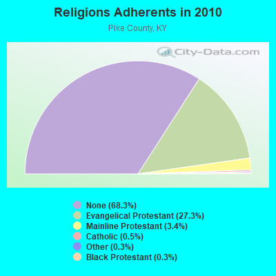
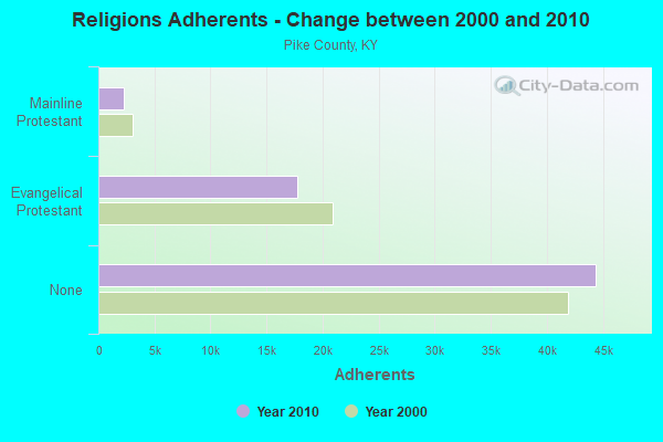
| Religion | Adherents | Congregations |
|---|---|---|
| Evangelical Protestant | 17,720 | 101 |
| Mainline Protestant | 2,227 | 15 |
| Catholic | 293 | 3 |
| Other | 213 | 3 |
| Black Protestant | 180 | 1 |
| None | 44,391 | - |
Food Environment Statistics:
| Pike County: | 3.51 / 10,000 pop. |
| Kentucky: | 2.19 / 10,000 pop. |
| This county: | 0.31 / 10,000 pop. |
| State: | 0.25 / 10,000 pop. |
| Pike County: | 0.31 / 10,000 pop. |
| Kentucky: | 0.74 / 10,000 pop. |
| Pike County: | 3.82 / 10,000 pop. |
| State: | 4.36 / 10,000 pop. |
| Here: | 4.12 / 10,000 pop. |
| State: | 5.74 / 10,000 pop. |
| This county: | 15.7% |
| Kentucky: | 11.0% |
| Pike County: | 33.3% |
| Kentucky: | 30.0% |
| This county: | 13.1% |
| State: | 15.9% |
Strongest AM radio stations in Ashcamp:
- WBPA (1460 AM; 5 kW; ELKHORN CITY, KY; Owner: EAST KENTUCKY BROADCASTING CORP)
- WDIC (1430 AM; daytime; 5 kW; CLINCHCO, VA; Owner: DICKENSON COUNTY BROADCASTING CORP.)
- WLSI (900 AM; 5 kW; PIKEVILLE, KY; Owner: EAST KENTUCKY BROADCASTING CORPORATION)
- WEZC (1480 AM; daytime; 5 kW; NEON, KY; Owner: JESUS COMMUNICATION ILNC.)
- WNRG (940 AM; 5 kW; GRUNDY, VA; Owner: VIRGINIA-KENTUCKY BROADCASTING CO., INC)
- WTCW (920 AM; 4 kW; WHITESBURG, KY; Owner: T.C.W. BROADCASTING , INC.)
- WNVA (1350 AM; 5 kW; NORTON, VA; Owner: RADIO-WISE, INC.)
- WKVG (1000 AM; daytime; 1 kW; JENKINS, KY; Owner: MARTINS & ASSOCIATES, INC.)
- WZAP (690 AM; 10 kW; BRISTOL, VA; Owner: RAM COMMUNICATIONS, INC.)
- WGOC (640 AM; 10 kW; BLOUNTVILLE, TN; Owner: CITADEL BROADCASTING COMPANY)
- WPRT (960 AM; 5 kW; PRESTONSBURG, KY; Owner: EAST KENTUCKY RADIO NETWORK, INC.)
- WKYH (600 AM; 5 kW; PAINTSVILLE, KY; Owner: HIGHLANDS BROADCASTING CORPORATION)
- WKVL (850 AM; daytime; 50 kW; KNOXVILLE, TN; Owner: HORNE RADIO, LLC)
Strongest FM radio stations in Ashcamp:
- WPKE-FM (103.1 FM; COAL RUN, KY; Owner: EAST KENTUCKY BROADCASTING CORP.)
- WDXC (102.3 FM; POUND, VA; Owner: WDXC RADIO, INC.)
- WDIC-FM (92.1 FM; CLINCHCO, VA; Owner: DICKENSON COUNTY BROADCASTING CORP.)
- WZLK (107.5 FM; VIRGIE, KY; Owner: EAST KENTUCKY BROADCASTING CORPORATION)
- WIFX-FM (94.3 FM; JENKINS, KY; Owner: LETCHER COUNTY BROADCASTING, INC)
- WXKQ-FM (103.9 FM; WHITESBURG, KY; Owner: T.C.W. BROADCASTING , INC.)
- WMMT (88.7 FM; WHITESBURG, KY; Owner: APPALSHOP, INCORPORATED)
- WDHR (93.1 FM; PIKEVILLE, KY; Owner: EAST KENTUCKY BROADCASTING CORP.)
- WXLR (104.9 FM; HAROLD, KY; Owner: ADAM D GEARHEART)
- WAXM (93.5 FM; BIG STONE GAP, VA; Owner: VALLEY BROADCASTING, INC.)
- WSEH (102.7 FM; CUMBERLAND, KY; Owner: CUMBERLAND CITY BROADCASTING, INC.)
- W223AA (92.5 FM; BIG STONE GAP, VA; Owner: VALLEY BROADCASTING, INC.)
- WJSO (90.1 FM; PIKEVILLE, KY; Owner: THE MOODY BIBLE INSTITUTE OF CHICAGO)
- WTFM (98.5 FM; KINGSPORT, TN; Owner: HOLSTON VALLEY BROADCASTING CORP.)
- W251AI (98.1 FM; PIKEVILLE, KY; Owner: EAST KENTUCKY BROADCASTING CORPORATION)
- WISE-FM (90.5 FM; WISE, VA; Owner: UNIVERSITY OF VIRGINIA'S COLLEGE AT WISE)
- WSGS (101.1 FM; HAZARD, KY; Owner: MOUNTAIN BROADCASTING SERVICE, INC.)
- WNVA-FM (106.3 FM; NORTON, VA; Owner: RADIO WISE, INC.)
- WHCB (91.5 FM; BRISTOL, TN; Owner: APPALACHIAN EDUC. COMMUNICATION CORP)
- WMJD (97.7 FM; GRUNDY, VA; Owner: VIRGINIA-KENTUCKY BROADCASTING CO., INC.)
TV broadcast stations around Ashcamp:
- WKPI-TV (Channel 22; PIKEVILLE, KY; Owner: KENTUCKY AUTHORITY FOR EDUCATIONAL TV)
- WYMT-TV (Channel 57; HAZARD, KY; Owner: WYMT LICENSEE CORP.)
- W24BT (Channel 24; TALBERT, KY; Owner: MS COMMUNICATIONS, LLC)

Ashcamp fatal accident list:
Jun 18, 2008 02:33 PM, Sr-197, Lat: 37.220900, Lon: -82.536980, Vehicles: 1, Persons: 1, Fatalities: 1
Sep 17, 2003 07:15 AM, Sr-197, Vehicles: 1, Persons: 1, Fatalities: 1
Dec 29, 2000 02:25 PM, Sr-195, Vehicles: 2, Persons: 4, Fatalities: 1
FCC Registered Amateur Radio Licenses:
3- Call Sign: KC4HSF, Grant Date: 11/29/1988, Expiration Date: 11/29/1998, Cancellation Date: 11/30/2000, Registrant: Jeffery D Ramey, Hc 72 Box 322, Ashcamp, KY 41512
- Call Sign: KF4EVE, Licensee ID: L01055558, Grant Date: 08/24/2005, Expiration Date: 11/22/2015, Cancellation Date: 11/23/2017, Certifier: N J Cantrell, Registrant: N J Cantrell, 10194 Elkhorn Cr Rd, Ashcamp, KY 41512
- Call Sign: KQ4HAX, Licensee ID: L02648096, Grant Date: 03/18/2023, Expiration Date: 03/18/2033, Certifier: Estil Bentley Iii, Registrant: Estil Bentley Iii, 111 Potters Grocery Rd, Ashcamp, KY 41512
FAA Registered Aircraft:
1- Aircraft: ROBINSON HELICOPTER COMPANY R44 II (Category: Land, Seats: 4, Weight: Up to 12,499 Pounds), Engine: LYCOMING IO-540 SER (300 HP) (Reciprocating)
N-Number: 357EB, N357EB, N-357EB, Serial Number: 10452, Year manufactured: 2004, Airworthiness Date: 08/13/2004, Certificate Issue Date: 11/03/2010
Registrant (Corporation): Bentley Distributing Inc, Po Box 146, Ashcamp, KY 41512

- 83.2%Electricity
- 6.0%Fuel oil, kerosene, etc.
- 4.3%Bottled, tank, or LP gas
- 4.2%Utility gas
- 1.5%Coal or coke
- 0.8%Wood

- 66.1%Electricity
- 25.4%Coal or coke
- 5.1%Utility gas
- 3.4%No fuel used
Ashcamp compared to Kentucky state average:
- Median household income below state average.
- Median house value below state average.
- Black race population percentage significantly below state average.
- Hispanic race population percentage significantly below state average.
- Median age below state average.
- Foreign-born population percentage significantly below state average.
- Renting percentage below state average.
- Length of stay since moving in significantly above state average.
- Number of rooms per house significantly below state average.
- House age significantly below state average.
- Number of college students below state average.
- Percentage of population with a bachelor's degree or higher significantly below state average.
Ashcamp on our top lists:
- #30 on the list of "Top 101 cities with the largest percentage of people in other nonhousehold living situations (population 1,000+)"
- #11 on the list of "Top 101 counties with the smallest number of children under 18 without health insurance coverage in 2000"
- #30 on the list of "Top 101 counties with the smallest number of people without health insurance coverage in 2000"
- #35 on the list of "Top 101 counties with the highest number of deaths per 1000 residents 2007-2013 (pop. 50,000+)"
- #45 on the list of "Top 101 counties with highest percentage of residents voting for Romney (Republican) in the 2012 Presidential Election (pop. 50,000+)"
- #53 on the list of "Top 101 counties with the lowest percentage of residents relocating to other counties in 2011 (pop. 50,000+)"