Cannel City, Kentucky
Submit your own pictures of this place and show them to the world
- OSM Map
- General Map
- Google Map
- MSN Map

| Males: 1,161 | |
| Females: 1,203 |
| Median resident age: | 36.6 years |
| Kentucky median age: | 35.9 years |
Zip code: 41408
| Cannel City: | $45,800 |
| KY: | $59,341 |
Estimated per capita income in 2022: $22,728 (it was $12,200 in 2000)
Cannel City CCD income, earnings, and wages data
Estimated median house or condo value in 2022: $81,126 (it was $37,300 in 2000)
| Cannel City: | $81,126 |
| KY: | $196,300 |
Mean prices in 2022: all housing units: $150,590; detached houses: $180,597; townhouses or other attached units: $154,533; mobile homes: $86,942
Detailed information about poverty and poor residents in Cannel City, KY
Compare current foreclosures near Cannel City, KY:
| Photo | Address | Area | Beds / Baths | Price | Details |
|---|---|---|---|---|---|

|
#1
Highway 460 W
West Liberty, KY 41472
|
784 sq. feet
|
1 baths 2 beds |
show details | |

|
#2
Grassy Creek Rd
Mize, KY 41352
|
- sq. feet
|
- baths - beds |
show details | |

|
#3
Hwy 15 South
Campton, KY 41301
|
- sq. feet
|
- baths - beds |
show details | |

|
#4
Harvest Ridge Rd
Campton, KY 41301
|
- sq. feet
|
- baths - beds |
show details | |

|
#5
Superior Rd
Salyersville, KY 41465
|
- sq. feet
|
- baths - beds |
show details | |

|
#6
E Maple St
Salyersville, KY 41465
|
- sq. feet
|
- baths - beds |
show details | |

|
#7
Highway 15 N
Vancleve, KY 41385
|
- sq. feet
|
- baths - beds |
show details | |

|
#8
Back St
Campton, KY 41301
|
- sq. feet
|
- baths - beds |
show details | |

|
#9
Twin Oaks Rd
Wellington, KY 40387
|
- sq. feet
|
- baths - beds |
show details | |

|
#10
Highway 1812 N
Vancleve, KY 41385
|
- sq. feet
|
- baths - beds |
show details |
| Photo | Address | Area | Beds / Baths | Price | Details |
|---|---|---|---|---|---|

|
#11
Ky 1036
Campton, KY 41301
|
- sq. feet
|
- baths - beds |
show details | |

|
#12
Highway 460 W
West Liberty, KY 41472
|
- sq. feet
|
- baths - beds |
show details | |

|
#13
Sunrise Ln
Denniston, KY 40316
|
- sq. feet
|
- baths - beds |
show details | |

|
#14
Ranger Rd
Salyersville, KY 41465
|
- sq. feet
|
- baths - beds |
show details | |

|
#15
Royalton Rd
Salyersville, KY 41465
|
- sq. feet
|
- baths - beds |
show details | |

|
#16
Morganview Rd
Wellington, KY 40387
|
- sq. feet
|
- baths - beds |
show details | |

|
#17
Charlie Ingram Rd
Wellington, KY 40387
|
- sq. feet
|
- baths - beds |
show details | |

|
#18
Highway 172
West Liberty, KY 41472
|
- sq. feet
|
- baths - beds |
show details | |

|
#19
Dale Back Rd
Frenchburg, KY 40322
|
- sq. feet
|
- baths - beds |
show details | |

|
#20
Ky 1812
Campton, KY 41301
|
- sq. feet
|
- baths - beds |
show details |
| Photo | Address | Area | Beds / Baths | Price | Details |
|---|---|---|---|---|---|

|
#21
Sugar Camp Rd
Salyersville, KY 41465
|
- sq. feet
|
- baths - beds |
show details | |

|
#22
Cave Run Hts
Wellington, KY 40387
|
- sq. feet
|
- baths - beds |
show details | |

|
#23
Lower Taulbee Fork Rd
Vancleve, KY 41385
|
- sq. feet
|
- baths - beds |
show details | |

|
#24
New Cummer Rd
West Liberty, KY 41472
|
- sq. feet
|
- baths - beds |
show details | |

|
#25
Cow Crk
Salyersville, KY 41465
|
- sq. feet
|
- baths - beds |
show details | |

|
#26
Highway 772
Ezel, KY 41425
|
- sq. feet
|
- baths - beds |
show details | |

|
#27
Gifford Rd
Salyersville, KY 41465
|
- sq. feet
|
- baths - beds |
show details | |

|
#28
Cow Branch Rd
West Liberty, KY 41472
|
- sq. feet
|
- baths - beds |
show details | |

|
#29
Townsend Drake Rd
Campton, KY 41301
|
- sq. feet
|
- baths - beds |
show details | |

|
#30
Highway 460 W
Salyersville, KY 41465
|
- sq. feet
|
- baths - beds |
show details |
| Photo | Address | Area | Beds / Baths | Price | Details |
|---|---|---|---|---|---|

|
#31
Lick Creek Rd
Salyersville, KY 41465
|
- sq. feet
|
- baths - beds |
show details | |

|
#32
Buffalo Creek Rd
Salyersville, KY 41465
|
- sq. feet
|
- baths - beds |
show details | |

|
#33
Clark Rowe Rd
Salyersville, KY 41465
|
- sq. feet
|
- baths - beds |
show details | |

|
#34
Highway 1161
West Liberty, KY 41472
|
- sq. feet
|
- baths - beds |
show details | |

|
#35
Highway 203
Hazel Green, KY 41332
|
- sq. feet
|
- baths - beds |
show details | |

|
#36
Mullins Point Rd
Campton, KY 41301
|
- sq. feet
|
- baths - beds |
show details | |

|
#37
Tree Nursery Rd
West Liberty, KY 41472
|
- sq. feet
|
- baths - beds |
show details | |

|
#38
Keeton Ave
West Liberty, KY 41472
|
- sq. feet
|
- baths - beds |
show details | |

|
#39
Highway 772
Ezel, KY 41425
|
- sq. feet
|
- baths - beds |
show details | |

|
#40
Woodside Ln
West Liberty, KY 41472
|
- sq. feet
|
- baths - beds |
show details |
| Photo | Address | Area | Beds / Baths | Price | Details |
|---|---|---|---|---|---|

|
#41
Us Highway 460 E
Wellington, KY 40387
|
- sq. feet
|
- baths - beds |
show details | |

|
#42
Highway 205
Campton, KY 41301
|
- sq. feet
|
- baths - beds |
show details | |

|
#43
Bentley Cir
Wellington, KY 40387
|
- sq. feet
|
- baths - beds |
show details | |

|
#44
Conley Br
West Liberty, KY 41472
|
- sq. feet
|
- baths - beds |
show details | |

|
#45
Igo Ridge Rd
Wellington, KY 40387
|
- sq. feet
|
- baths - beds |
show details | |

|
#46
Highway 3345
Ezel, KY 41425
|
- sq. feet
|
- baths - beds |
show details | |

|
Check over 1 million property listings on Foreclosure.com!
|
browse all offers | |||

- 2,29599.1%White alone
- 120.5%Two or more races
- 70.3%Hispanic
- 10.04%Black alone
- 10.04%American Indian alone

Races in Cannel City detailed stats: ancestries, foreign born residents, place of birth
 Recent articles from our blog. Our writers, many of them Ph.D. graduates or candidates, create easy-to-read articles on a wide variety of topics.
Current Local Time: EST time zone
Land area: 61.5 square miles.
Population density: 38 people per square mile (very low).

| Cannel City CCD: | 0.6% ($236) |
| Kentucky: | 0.8% ($610) |
Nearest city with pop. 50,000+: Huntington, WV  (62.6 miles , pop. 51,475).
Nearest city with pop. 200,000+: Fayette, KY (67.0 miles , pop. 260,512).
Nearest city with pop. 1,000,000+: Chicago, IL (362.7 miles , pop. 2,896,016).
Nearest cities:
), ), ), ), ), )Latitude: 37.82 N, Longitude: 83.30 W
Area code commonly used in this area: 606


| Here: | 5.6% |
| Kentucky: | 3.8% |

- Public administration (17.2%)
- Construction (11.3%)
- Health care (10.5%)
- Educational services (6.1%)
- Broadcasting & telecommunications (4.5%)
- Food & beverage stores (3.4%)
- Machinery (3.3%)

- Construction (16.9%)
- Public administration (13.4%)
- Health care (7.8%)
- Repair & maintenance (5.4%)
- Food & beverage stores (5.0%)
- Educational services (4.8%)
- Agriculture, forestry, fishing & hunting (4.7%)

- Public administration (22.2%)
- Health care (14.0%)
- Broadcasting & telecommunications (8.4%)
- Educational services (7.7%)
- Department & other general merchandise stores (7.1%)
- Textile mills & textile products (5.1%)
- Accommodation & food services (4.8%)

- Law enforcement workers, including supervisors (6.2%)
- Health technologists and technicians (5.5%)
- Construction traders workers except carpenters, electricians, painters, plumbers, and construction laborers (4.8%)
- Cashiers (4.8%)
- Electrical equipment mechanics and other installation, maintenance, and repair workers, including supervisors (4.7%)
- Other production occupations, including supervisors (4.6%)
- Textile, apparel, and furnishings workers (4.2%)

- Law enforcement workers, including supervisors (8.3%)
- Construction traders workers except carpenters, electricians, painters, plumbers, and construction laborers (8.3%)
- Metal workers and plastic workers (6.6%)
- Health technologists and technicians (5.2%)
- Cashiers (5.0%)
- Other production occupations, including supervisors (4.8%)
- Driver/sales workers and truck drivers (4.5%)

- Secretaries and administrative assistants (7.9%)
- Textile, apparel, and furnishings workers (7.7%)
- Electrical equipment mechanics and other installation, maintenance, and repair workers, including supervisors (7.1%)
- Food and beverage serving workers, except waiters and waitresses (6.6%)
- Other office and administrative support workers, including supervisors (6.1%)
- Health technologists and technicians (5.9%)
- Nursing, psychiatric, and home health aides (5.4%)
Average climate in Cannel City, Kentucky
Based on data reported by over 4,000 weather stations


Tornado activity:
Cannel City-area historical tornado activity is significantly below Kentucky state average. It is 47% smaller than the overall U.S. average.
On 4/3/1974, a category F4 (max. wind speeds 207-260 mph) tornado 44.7 miles away from the Cannel City place center killed 7 people and injured 28 people.
On 6/9/1961, a category F3 (max. wind speeds 158-206 mph) tornado 27.7 miles away from the place center killed one person and injured 63 people and caused between $500,000 and $5,000,000 in damages.
Earthquake activity:
Cannel City-area historical earthquake activity is significantly above Kentucky state average. It is 38% greater than the overall U.S. average.On 7/27/1980 at 18:52:21, a magnitude 5.2 (5.1 MB, 4.7 MS, 5.0 UK, 5.2 UK, Class: Moderate, Intensity: VI - VII) earthquake occurred 44.3 miles away from Cannel City center
On 9/7/1988 at 02:28:09, a magnitude 4.6 (4.5 MB, 4.6 LG, Class: Light, Intensity: IV - V) earthquake occurred 38.9 miles away from Cannel City center
On 8/9/2020 at 12:07:37, a magnitude 5.1 (5.1 MW, Depth: 4.7 mi) earthquake occurred 152.9 miles away from the city center
On 8/23/2011 at 17:51:04, a magnitude 5.8 (5.8 MW, Depth: 3.7 mi) earthquake occurred 292.8 miles away from the city center
On 4/18/2008 at 09:36:59, a magnitude 5.4 (5.1 MB, 4.8 MS, 5.4 MW, 5.2 MW) earthquake occurred 253.4 miles away from the city center
On 11/30/1973 at 07:48:41, a magnitude 4.7 (4.7 MB, 4.6 ML) earthquake occurred 144.3 miles away from Cannel City center
Magnitude types: regional Lg-wave magnitude (LG), body-wave magnitude (MB), local magnitude (ML), surface-wave magnitude (MS), moment magnitude (MW)
Natural disasters:
The number of natural disasters in Morgan County (24) is greater than the US average (15).Major Disasters (Presidential) Declared: 19
Emergencies Declared: 3
Causes of natural disasters: Floods: 16, Storms: 14, Mudslides: 8, Tornadoes: 7, Winter Storms: 7, Landslides: 6, Winds: 4, Snowstorms: 2, Blizzard: 1, Freeze: 1, Hurricane: 1, Snow: 1, Snowfall: 1, Other: 1 (Note: some incidents may be assigned to more than one category).
Colleges/universities with over 2000 students nearest to Cannel City:
- Morehead State University (about 27 miles; Morehead, KY; Full-time enrollment: 7,523)
- Big Sandy Community and Technical College (about 30 miles; Prestonsburg, KY; FT enrollment: 2,660)
- Hazard Community and Technical College (about 41 miles; Hazard, KY; FT enrollment: 2,087)
- Eastern Kentucky University (about 56 miles; Richmond, KY; FT enrollment: 13,525)
- Ashland Community and Technical College (about 58 miles; Ashland, KY; FT enrollment: 2,482)
- Southeast Kentucky Community and Technical College (about 61 miles; Cumberland, KY; FT enrollment: 2,196)
- Maysville Community and Technical College (about 63 miles; Maysville, KY; FT enrollment: 2,969)
Points of interest:
Notable location: The Chapel (A). Display/hide its location on the map
Churches in Cannel City include: Grassy Lick Church (A), Wells Chapel (B), Little Caney Church (C), Salem Fork Christian Church (D), Rockcastle Baptist Church (E), Centerville Enterprise Baptist Church (F), Brushy Fork United Baptist Church (G), Consolation Mission Church (H), Elam Church (I). Display/hide their locations on the map
Cemeteries: Henry Cemetery (1), Elam Cemetery (2), Combs Cemetery (3), Conley Cemetery (4), Deboard Cemetery (5), Morris Cemetery (6), Salem Cemetery (7). Display/hide their locations on the map
Streams, rivers, and creeks: Barker Branch (A), Bear Branch (B), Benton Branch (C), Big Staff Branch (D), Doe Branch (E), Yearling Branch (F), Phils Branch (G), Phipps Fork (H), Webb Branch (I). Display/hide their locations on the map
Birthplace of: Rabbit Benton - Baseball player.
| This place: | 2.5 people |
| Kentucky: | 2.5 people |
| This place: | 72.0% |
| Whole state: | 66.9% |
| This place: | 4.8% |
| Whole state: | 6.4% |
Likely homosexual households (counted as self-reported same-sex unmarried-partner households)
- Lesbian couples: 0.5% of all households
- Gay men: 0.1% of all households
| This place: | 23.4% |
| Whole state: | 15.8% |
| This place: | 7.4% |
| Whole state: | 6.6% |
For population 15 years and over in Cannel City:

- Never married: 16.7%
- Now married: 66.8%
- Separated: 1.1%
- Widowed: 6.2%
- Divorced: 10.3%
For population 25 years and over in Cannel City:
- High school or higher: 59.0%
- Bachelor's degree or higher: 7.7%
- Graduate or professional degree: 3.3%
- Unemployed: 6.5%
- Mean travel time to work (commute): 32.8 minutes


| Here: | 15.5 |
| Kentucky average: | 13.8 |
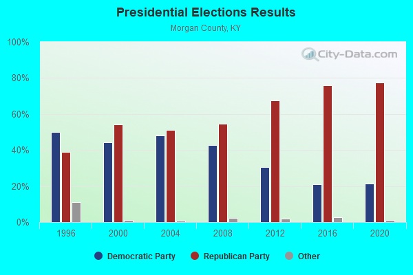
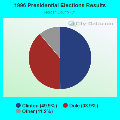
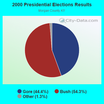
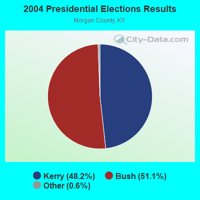
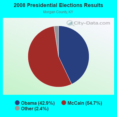
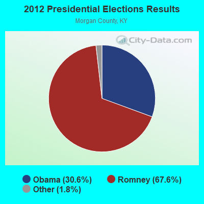
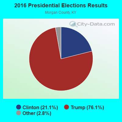
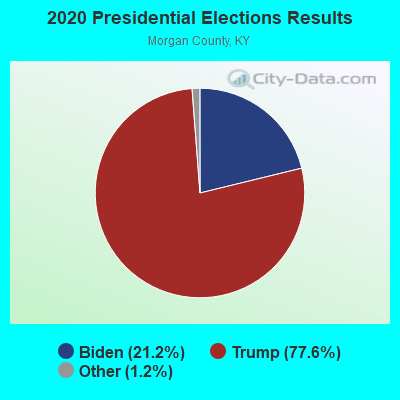
Graphs represent county-level data. Detailed 2008 Election Results
Religion statistics for Cannel City, KY (based on Morgan County data)

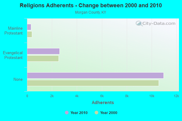
| Religion | Adherents | Congregations |
|---|---|---|
| Evangelical Protestant | 2,600 | 30 |
| Mainline Protestant | 315 | 4 |
| Catholic | 52 | 1 |
| Other | 1 | 1 |
| None | 10,955 | - |
Food Environment Statistics:
| Morgan County: | 4.22 / 10,000 pop. |
| Kentucky: | 2.19 / 10,000 pop. |
| Morgan County: | 2.81 / 10,000 pop. |
| Kentucky: | 0.74 / 10,000 pop. |
| This county: | 6.33 / 10,000 pop. |
| Kentucky: | 4.36 / 10,000 pop. |
| Morgan County: | 2.81 / 10,000 pop. |
| Kentucky: | 5.74 / 10,000 pop. |
| This county: | 12.1% |
| Kentucky: | 11.0% |
| Here: | 32.2% |
| Kentucky: | 30.0% |
| This county: | 17.7% |
| Kentucky: | 15.9% |
Strongest AM radio stations in Cannel City:
- WMTC (730 AM; 5 kW; VANCLEVE, KY; Owner: THE KENTUCKY MOUNTAIN HOLINESS ASSN.)
- WEKG (810 AM; daytime; 5 kW; JACKSON, KY; Owner: INTERMOUNTAIN B/CING CO., INC.)
- WLKS (1450 AM; 1 kW; WEST LIBERTY, KY; Owner: MORGAN COUNTY INDUSTRIES, INC.)
- WKYH (600 AM; 5 kW; PAINTSVILLE, KY; Owner: HIGHLANDS BROADCASTING CORPORATION)
- WRLV (1140 AM; daytime; 1 kW; SALYERSVILLE, KY; Owner: WALLINGFORD BROADCASTING COMPANY, INC)
- WPRT (960 AM; 5 kW; PRESTONSBURG, KY; Owner: EAST KENTUCKY RADIO NETWORK, INC.)
- WTVN (610 AM; 50 kW; COLUMBUS, OH; Owner: CITICASTERS LICENSES, L.P.)
- WLW (700 AM; 50 kW; CINCINNATI, OH; Owner: JACOR BROADCASTING CORPORATION)
- WDOC (1310 AM; 5 kW; PRESTONSBURG, KY)
- WHAS (840 AM; 50 kW; LOUISVILLE, KY; Owner: CLEAR CHANNEL BROADCASTING LICENSES, INC.)
- WKVL (850 AM; daytime; 50 kW; KNOXVILLE, TN; Owner: HORNE RADIO, LLC)
- WSAI (1530 AM; 50 kW; CINCINNATI, OH; Owner: JACOR BROADCASTING CORPORATION)
- WGOH (1370 AM; 5 kW; GRAYSON, KY; Owner: CARTER COUNTY BROADCASTING CO., INC.)
Strongest FM radio stations in Cannel City:
- WJSN-FM (106.5 FM; JACKSON, KY; Owner: INTERMOUNTAIN BROADCASTING CO.)
- WMKY (90.3 FM; MOREHEAD, KY; Owner: MOREHEAD STATE UNIVERSITY)
- WRLV-FM (106.5 FM; SALYERSVILLE, KY; Owner: WALLINGFORD BROADCASTING COMPANY, INC.)
- WCBJ (103.7 FM; CAMPTON, KY; Owner: MORGAN COUNTY INDUSTRIES INC)
- WQHY (95.5 FM; PRESTONSBURG, KY; Owner: WDOC, INC.)
- WSGS (101.1 FM; HAZARD, KY; Owner: MOUNTAIN BROADCASTING SERVICE, INC.)
- WZQQ (97.9 FM; HYDEN, KY; Owner: LESLIE COUNTY BROADCASTING, INC.)
- WKLW-FM (94.7 FM; PAINTSVILLE, KY; Owner: B & G BROADCASTING, INC.)
- WLJC (102.1 FM; BEATTYVILLE, KY; Owner: HOUR OF HARVEST, INCORPORATED)
- WLKS-FM (102.9 FM; WEST LIBERTY, KY; Owner: MORGAN COUNTY INDUSTRIES, INC.)
- WJMD (104.7 FM; HAZARD, KY; Owner: HAZARD BROADCASTING SERVICES)
- WSEH (102.7 FM; CUMBERLAND, KY; Owner: CUMBERLAND CITY BROADCASTING, INC.)
- WMTC-FM (99.9 FM; VANCLEVE, KY; Owner: KENTUCKY MOUNTAIN HOLINESS ASSOC.)
- WSIP-FM (98.9 FM; PAINTSVILLE, KY; Owner: SIP BROADCASTING, INC.)
- WSKV-FM (104.9 FM; STANTON, KY; Owner: PARKS BROADCASTING, INC.)
- WEKH (90.9 FM; HAZARD, KY; Owner: EASTERN KENTUCKY UNIVERSITY)
- WBMK (88.5 FM; MOREHEAD, KY; Owner: AMERICAN FAMILY ASSOCIATION)
TV broadcast stations around Cannel City:
- WUPX-TV (Channel 67; MOREHEAD, KY; Owner: PAXSON LEXINGTON LICENSE, INC.)
- W26BK (Channel 26; TALBERT, KY; Owner: MS COMMUNICATIONS, LLC)
- W16BI (Channel 16; TALBERT, KY; Owner: MS COMMUNICATIONS, LLC)
- WLJC-TV (Channel 65; BEATTYVILLE, KY; Owner: HOUR OF HARVEST, INC.)
- W64CM (Channel 64; TALBERT, KY; Owner: MS COMMUNICATIONS, LLC)
- W66DA (Channel 66; TALBERT, KY; Owner: MS COMMUNICATIONS, LLC)
- WKMR (Channel 38; MOREHEAD, KY; Owner: KENTUCKY AUTHORITY FOR EDUCATIONAL TV)
- WYMT-TV (Channel 57; HAZARD, KY; Owner: WYMT LICENSEE CORP.)
- W54CI (Channel 54; TALBERT, KY; Owner: MS COMMUNICATIONS, LLC)

Cannel City fatal accident list:
FCC Registered Amateur Radio Licenses:
2- Call Sign: KF4FSM, Licensee ID: L00259130, Grant Date: 01/19/2016, Expiration Date: 01/12/2026, Certifier: Gerald T Gevedon, Registrant: Gerald T Gevedon, 9245 Hwy 191, Cannel City, KY 41408
- Call Sign: KI6BUD, Licensee ID: L01095511, Grant Date: 02/11/2016, Expiration Date: 02/11/2026, Certifier: Richard A Clark, Registrant: Richard A Clark, Po Box 3, Cannel City, KY 41408

- 50.3%Bottled, tank, or LP gas
- 32.1%Electricity
- 6.2%Wood
- 4.3%Fuel oil, kerosene, etc.
- 3.9%Coal or coke
- 2.5%Other fuel
- 0.8%Utility gas

- 45.9%Bottled, tank, or LP gas
- 17.1%Wood
- 12.3%Utility gas
- 12.3%Electricity
- 7.5%Coal or coke
- 4.8%Fuel oil, kerosene, etc.
Cannel City compared to Kentucky state average:
- Median house value significantly below state average.
- Unemployed percentage below state average.
- Black race population percentage significantly below state average.
- Hispanic race population percentage significantly below state average.
- Median age below state average.
- Foreign-born population percentage significantly below state average.
- Renting percentage below state average.
- Length of stay since moving in significantly above state average.
- Number of rooms per house significantly below state average.
- House age significantly below state average.
- Percentage of population with a bachelor's degree or higher significantly below state average.