Clementsville, Kentucky
Submit your own pictures of this place and show them to the world
- OSM Map
- General Map
- Google Map
- MSN Map

| Males: 1,188 | |
| Females: 1,260 |
| Median resident age: | 36.8 years |
| Kentucky median age: | 35.9 years |
Zip code: 42539
| Clementsville: | $41,072 |
| KY: | $59,341 |
Estimated per capita income in 2022: $21,267 (it was $11,750 in 2000)
Clementsville CCD income, earnings, and wages data
Estimated median house or condo value in 2022: $135,751 (it was $45,200 in 2000)
| Clementsville: | $135,751 |
| KY: | $196,300 |
Mean prices in 2022: all housing units: $145,827; detached houses: $175,931; townhouses or other attached units: $75,954; mobile homes: $51,373
Detailed information about poverty and poor residents in Clementsville, KY


- 2,24996.7%White alone
- 462.0%Hispanic
- 110.5%American Indian alone
- 100.4%Two or more races
- 80.3%Black alone
- 20.09%Asian alone

Races in Clementsville detailed stats: ancestries, foreign born residents, place of birth
 Recent articles from our blog. Our writers, many of them Ph.D. graduates or candidates, create easy-to-read articles on a wide variety of topics.
Current Local Time: EST time zone
Elevation: 771 feet
Land area: 70.8 square miles.
Population density: 35 people per square mile (very low).

| Clementsville CCD: | 0.6% ($258) |
| Kentucky: | 0.8% ($610) |
Nearest city with pop. 50,000+: Fayette, KY  (57.7 miles , pop. 260,512).
Nearest city with pop. 1,000,000+: Chicago, IL (341.4 miles , pop. 2,896,016).
Nearest cities:
), ), Latitude: 37.33 N, Longitude: 85.07 W


| Here: | 3.8% |
| Kentucky: | 3.8% |

- Construction (9.6%)
- Health care (9.2%)
- Agriculture, forestry, fishing & hunting (6.3%)
- Educational services (5.8%)
- Administrative & support & waste management services (5.7%)
- Apparel (5.3%)
- Wood products (4.6%)

- Construction (14.9%)
- Agriculture, forestry, fishing & hunting (10.6%)
- Repair & maintenance (5.7%)
- Wood products (5.7%)
- Machinery (5.6%)
- Administrative & support & waste management services (5.2%)
- Electrical equipment, appliances, components (4.7%)

- Health care (19.3%)
- Educational services (10.6%)
- Apparel (10.0%)
- Accommodation & food services (7.9%)
- Administrative & support & waste management services (6.3%)
- Professional, scientific, technical services (4.7%)
- Public administration (4.0%)

- Metal workers and plastic workers (7.7%)
- Building and grounds cleaning and maintenance occupations (7.4%)
- Other production occupations, including supervisors (5.4%)
- Driver/sales workers and truck drivers (4.9%)
- Textile, apparel, and furnishings workers (4.7%)
- Vehicle and mobile equipment mechanics, installers, and repairers (4.3%)
- Secretaries and administrative assistants (4.0%)

- Metal workers and plastic workers (11.7%)
- Vehicle and mobile equipment mechanics, installers, and repairers (7.2%)
- Driver/sales workers and truck drivers (6.8%)
- Other production occupations, including supervisors (6.6%)
- Building and grounds cleaning and maintenance occupations (5.6%)
- Electrical equipment mechanics and other installation, maintenance, and repair workers, including supervisors (5.4%)
- Supervisors, construction and extraction workers (4.7%)

- Building and grounds cleaning and maintenance occupations (10.0%)
- Textile, apparel, and furnishings workers (10.0%)
- Secretaries and administrative assistants (9.8%)
- Nursing, psychiatric, and home health aides (8.2%)
- Other office and administrative support workers, including supervisors (4.7%)
- Waiters and waitresses (4.5%)
- Accountants and auditors (4.2%)
Average climate in Clementsville, Kentucky
Based on data reported by over 4,000 weather stations


Tornado activity:
Clementsville-area historical tornado activity is near Kentucky state average. It is 36% greater than the overall U.S. average.
On 4/3/1974, a category F4 (max. wind speeds 207-260 mph) tornado 6.3 miles away from the Clementsville place center injured 56 people and caused between $500,000 and $5,000,000 in damages.
On 4/27/1971, a category F4 tornado 15.6 miles away from the place center killed 6 people and injured 58 people.
Earthquake activity:
Clementsville-area historical earthquake activity is significantly above Kentucky state average. It is 105% greater than the overall U.S. average.On 7/27/1980 at 18:52:21, a magnitude 5.2 (5.1 MB, 4.7 MS, 5.0 UK, 5.2 UK, Class: Moderate, Intensity: VI - VII) earthquake occurred 86.4 miles away from Clementsville center
On 4/18/2008 at 09:36:59, a magnitude 5.4 (5.1 MB, 4.8 MS, 5.4 MW, 5.2 MW) earthquake occurred 172.0 miles away from Clementsville center
On 4/18/2008 at 09:36:59, a magnitude 5.2 (5.2 MW, Depth: 8.9 mi) earthquake occurred 172.0 miles away from the city center
On 6/18/2002 at 17:37:15, a magnitude 5.0 (4.3 MB, 4.6 MW, 5.0 LG) earthquake occurred 155.0 miles away from the city center
On 6/10/1987 at 23:48:54, a magnitude 5.1 (4.9 MB, 4.4 MS, 4.6 MS, 5.1 LG) earthquake occurred 184.5 miles away from Clementsville center
On 9/7/1988 at 02:28:09, a magnitude 4.6 (4.5 MB, 4.6 LG, Class: Light, Intensity: IV - V) earthquake occurred 86.1 miles away from Clementsville center
Magnitude types: regional Lg-wave magnitude (LG), body-wave magnitude (MB), surface-wave magnitude (MS), moment magnitude (MW)
Natural disasters:
The number of natural disasters in Casey County (23) is greater than the US average (15).Major Disasters (Presidential) Declared: 18
Emergencies Declared: 3
Causes of natural disasters: Floods: 14, Storms: 13, Tornadoes: 7, Winter Storms: 6, Mudslides: 4, Winds: 3, Landslides: 2, Blizzard: 1, Freeze: 1, Hurricane: 1, Snow: 1, Snowfall: 1, Snowstorm: 1, Other: 1 (Note: some incidents may be assigned to more than one category).
Hospitals and medical centers near Clementsville:
- CASEY COUNTY HOSPITAL Critical Access Hospitals (about 8 miles away; LIBERTY, KY)
- DAVITA - TAYLOR COUNTY DIALYSIS (Dialysis Facility, about 15 miles away; CAMPBELLSVILLE, KY)
- TAYLOR REGIONAL HOSPITAL Acute Care Hospitals (about 15 miles away; CAMPBELLSVILLE, KY)
- METZMEIER NH (Nursing Home, about 16 miles away; CAMPBELLSVILLE, KY)
Colleges/universities with over 2000 students nearest to Clementsville:
- Campbellsville University (about 16 miles; Campbellsville, KY; Full-time enrollment: 2,948)
- Lindsey Wilson College (about 21 miles; Columbia, KY; FT enrollment: 2,552)
- Somerset Community College (about 32 miles; Somerset, KY; FT enrollment: 4,698)
- Elizabethtown Community and Technical College (about 51 miles; Elizabethtown, KY; FT enrollment: 3,762)
- Eastern Kentucky University (about 51 miles; Richmond, KY; FT enrollment: 13,525)
- Bluegrass Community and Technical College (about 58 miles; Lexington, KY; FT enrollment: 8,560)
- University of Kentucky (about 58 miles; Lexington, KY; FT enrollment: 23,517)
Points of interest:
Notable locations in Clementsville: Noel Chapel (A), Clementsville Volunteer Fire Department (B). Display/hide their locations on the map
Churches in Clementsville include: Jones Chapel (A), White Oak Church (B), Pleasant Grove Church (C), Antioch Church (D), Bethlehem Church (E), Block Church (F), Carr Chapel First Church of God (G), Shady Grove Church (H), Cole Spring Church (I). Display/hide their locations on the map
Cemeteries: Peavy Cemetery (1), Carr Cemetery (2), Shady Grove Cemetery (3), Scotts Chapel Cemetery (4), Pine Grove Baptist Church Cemetery (5), Jones Chapel Cemetery (6), Cole Spring Cemetery (7). Display/hide their locations on the map
Streams, rivers, and creeks: Bem Branch (A), Woods Creek (B), Sulphur Run (C), Bull Run Creek (D), Long Branch (E), Hicks Branch (F), Gum Lick Creek (G), McClures Fork (H). Display/hide their locations on the map
| This place: | 2.4 people |
| Kentucky: | 2.5 people |
| This place: | 68.1% |
| Whole state: | 66.9% |
| This place: | 5.0% |
| Whole state: | 6.4% |
Likely homosexual households (counted as self-reported same-sex unmarried-partner households)
- Lesbian couples: 0.1% of all households
- Gay men: 0.2% of all households
| This place: | 25.8% |
| Whole state: | 15.8% |
| This place: | 4.2% |
| Whole state: | 6.6% |
For population 15 years and over in Clementsville:

- Never married: 19.6%
- Now married: 60.1%
- Separated: 0.5%
- Widowed: 9.3%
- Divorced: 11.0%
For population 25 years and over in Clementsville:
- High school or higher: 57.0%
- Bachelor's degree or higher: 5.7%
- Graduate or professional degree: 3.3%
- Unemployed: 7.5%
- Mean travel time to work (commute): 32.4 minutes


| Here: | 15.8 |
| Kentucky average: | 13.8 |
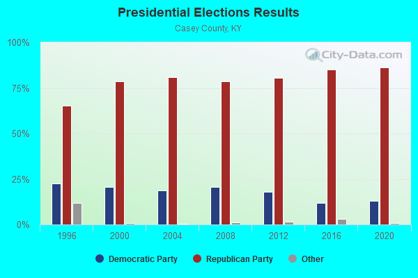
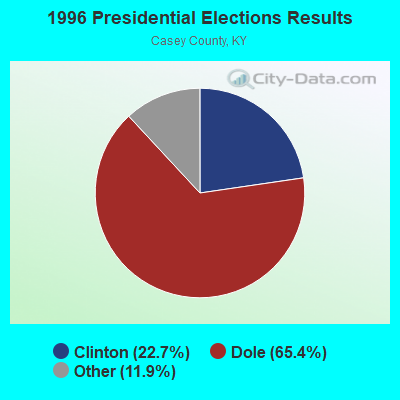
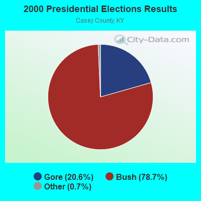
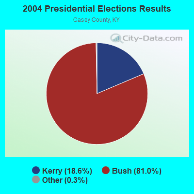
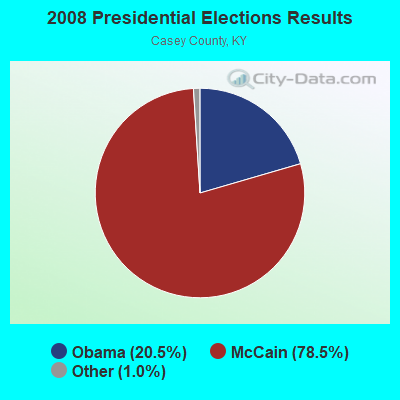
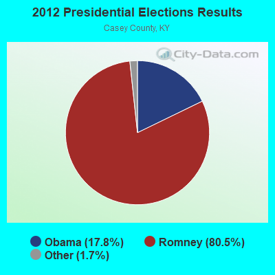
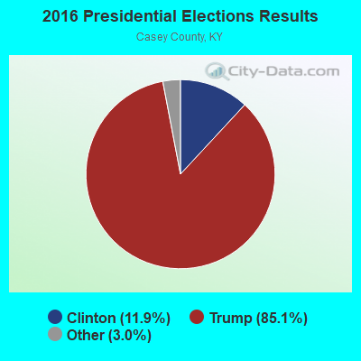

Graphs represent county-level data. Detailed 2008 Election Results
Religion statistics for Clementsville, KY (based on Casey County data)
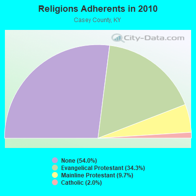
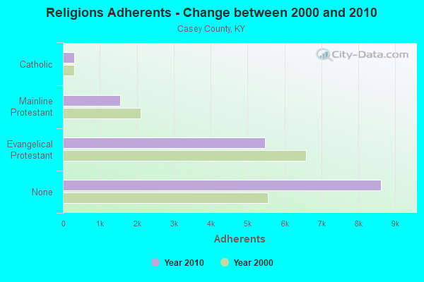
| Religion | Adherents | Congregations |
|---|---|---|
| Evangelical Protestant | 5,470 | 46 |
| Mainline Protestant | 1,554 | 13 |
| Catholic | 312 | 2 |
| Other | 2 | - |
| None | 8,617 | - |
Food Environment Statistics:
| Here: | 4.34 / 10,000 pop. |
| Kentucky: | 2.19 / 10,000 pop. |
| Here: | 2.48 / 10,000 pop. |
| State: | 0.74 / 10,000 pop. |
| Here: | 6.82 / 10,000 pop. |
| Kentucky: | 4.36 / 10,000 pop. |
| Casey County: | 3.72 / 10,000 pop. |
| Kentucky: | 5.74 / 10,000 pop. |
| Casey County: | 12.7% |
| Kentucky: | 11.0% |
| Here: | 31.2% |
| Kentucky: | 30.0% |
| Casey County: | 15.1% |
| Kentucky: | 15.9% |
Strongest AM radio stations in Clementsville:
- WHAS (840 AM; 50 kW; LOUISVILLE, KY; Owner: CLEAR CHANNEL BROADCASTING LICENSES, INC.)
- WKDO (1560 AM; daytime; 1 kW; LIBERTY, KY; Owner: CARLOS WESLEY)
- WKVL (850 AM; daytime; 50 kW; KNOXVILLE, TN; Owner: HORNE RADIO, LLC)
- WSM (650 AM; 50 kW; NASHVILLE, TN; Owner: GAYLORD ENTERTAINMENT COMPANY)
- WLW (700 AM; 50 kW; CINCINNATI, OH; Owner: JACOR BROADCASTING CORPORATION)
- WIDS (570 AM; 0 kW; RUSSELL SPRINGS, KY; Owner: HAMMOND BROADCASTING, INC.)
- WAMB (1160 AM; 50 kW; DONELSON, TN; Owner: GREAT SOUTHERN BROADCASTING COMPANY, INC.)
- WKDA (1200 AM; 50 kW; NASHVILLE, TN; Owner: RADIO NASHVILLE, INC.)
- WTCO (1450 AM; 1 kW; CAMPBELLSVILLE, KY; Owner: CBC OF MARION & TAYLOR COUNTIES INC)
- WLAC (1510 AM; 50 kW; NASHVILLE, TN; Owner: CAPSTAR TX LIMITED PARTNERSHIP)
- WNQM (1300 AM; 50 kW; NASHVILLE, TN; Owner: WNQM. INC.)
- WWAM (820 AM; daytime; 50 kW; JASPER, TN; Owner: SHELTON BROADCASTING SYSTEM)
- WSAI (1530 AM; 50 kW; CINCINNATI, OH; Owner: JACOR BROADCASTING CORPORATION)
Strongest FM radio stations in Clementsville:
- WDCL-FM (89.7 FM; SOMERSET, KY; Owner: WESTERN KENTUCKY UNIVERSITY)
- WVLC (99.9 FM; MANNSVILLE, KY; Owner: PATRICIA RODGERS)
- WXKY-FM (96.3 FM; STANFORD, KY; Owner: LINCOLN-GARRARD BROADCASTING CO.,INC)
- WKDO-FM (98.7 FM; LIBERTY, KY; Owner: CARLOS D. WESLEY)
- WCKQ (104.1 FM; CAMPBELLSVILLE, KY; Owner: CBC OF MARION & TAYLOR COUNTIES INC)
- WSEK (97.1 FM; SOMERSET, KY; Owner: CAPSTAR TX LIMITED PARTNERSHIP)
- WAPD (91.7 FM; CAMPBELLSVILLE, KY; Owner: AMERICAN FAMILY ASSOCIATION)
- WJRS (104.9 FM; JAMESTOWN, KY; Owner: LAKE CUMBERLAND BROADCASTERS)
- WTHL (90.5 FM; SOMERSET, KY; Owner: SOMERSET EDUCATIONAL BROADCASTING FOUNDATION)
- WHVE (92.7 FM; RUSSELL SPRINGS, KY; Owner: SHORELINE COMMUNICATIONS, INC)
- WDFB-FM (88.1 FM; DANVILLE, KY; Owner: ALUM SPRINGS EDUCATIONAL CORPORATION)
- WGRK-FM (103.1 FM; GREENSBURG, KY; Owner: GREEN COUNTY CBC, INC.)
- WAKY-FM (102.7 FM; SPRINGFIELD, KY; Owner: WASHINGTON COUNTY CBC, INC.)
- WLSK (100.9 FM; LEBANON, KY; Owner: CBC OF MARION COUNTY, INC)
TV broadcast stations around Clementsville:
- WKSO-TV (Channel 29; SOMERSET, KY; Owner: KENTUCKY AUTHORITY FOR EDUCATIONAL TV)
- WBKI-TV (Channel 34; CAMPBELLSVILLE, KY; Owner: LOUISVILLE COMMUNICATIONS, LLC)
- WDKY-TV (Channel 56; DANVILLE, KY; Owner: WDKY LICENSEE, LLC)
- W04BP (Channel 4; CAMPBELLSVILLE, KY; Owner: CAMPSVILLE UNIVERSITY)
FCC Registered Antenna Towers:
6- RICHARD C GILLESPIE, 4 Mi Ne (Lat: 37.310000 Lon: -85.062500), Type: 95.5, Overall height: 94.5 m, Registrant: Columbia Network Services Corporation, Mjones@nisource.Com, , 1273 Charl-eston, Phone: (304) 357-2222
- Richard Gillespie, 4 Mi Ne (Lat: 37.310000 Lon: -85.062500), Type: 95.5, Structure height: 21045 m, Overall height: 94.5 m, Registrant: Cns Microwave, LLC, Rcgillespie@cpg.Com, , Charl-eston, Phone: (304) 357-3187
- Angela E Giancarlo, 4 Mi Ne (Lat: 37.310000 Lon: -85.062500), Type: 95.5, Structure height: 21045 m, Overall height: 94.5 m, Registrant: Cns Microwave, LLC, Rcgillespie@cpg.Com, , Charl-eston, Phone: (304) 357-3187
- Richard Gillespie, 4 Mi Ne (Lat: 37.310000 Lon: -85.062500), Type: 95.5, Structure height: 21045 m, Overall height: 94.5 m, Registrant: Cns Microwave, LLC, Rick_gillespie@transcanada.Com, , Charl-eston, Phone: (304) 357-3187
- Melissa Jones, 4 Mi Ne (Lat: 37.310000 Lon: -85.062500), Type: 95.5, Structure height: 21045 m, Overall height: 94.5 m, Registrant: Cns Microwave, LLC, Melissa_jones@tcenergy.Com, , 1273 Charl-eston, Phone: (304) 357-2222
- 4 Mi Ne (Lat: 37.310000 Lon: -85.062500), Type: 95.5, Overall height: 94.5 m, Registrant: Columbia Network Services Corporation, Pkrumm@columbiaenergygroup.Com, , Colum-bus, Phone: (614) 481-1436
FCC Registered Broadcast Land Mobile Towers:
2- Appox 4 Mi Ne (Lat: 37.310083 Lon: -85.062444), Call Sign: KII214,
Assigned Frequencies: 48.7200 MHz, Grant Date: 12/06/2011, Expiration Date: 12/11/2021, Cancellation Date: 04/30/2021, Certifier: Matthew Agen, Registrant: Spectrum And Licensing Services, 11 Lee Street, Hanover, PA 17331, Phone: (717) 630-0816, Fax: (717) 637-8300, Email:
- 11298 West Ky 70 (Lat: 37.288861 Lon: -85.091167), Type: Mast, Structure height: 24.4 m, Call Sign: WQAL483,
Assigned Frequencies: 460.637 MHz, Grant Date: 04/05/2014, Expiration Date: 06/28/2024, Certifier: Ronald Wright, Registrant: Rcs Communications, 2539 Regency Rd., Ste. 103, Lexington, KY 40503, Phone: (502) 587-7384, Fax: (502) 584-6999, Email:

- 47.9%Electricity
- 26.5%Wood
- 15.4%Bottled, tank, or LP gas
- 6.6%Fuel oil, kerosene, etc.
- 3.6%Utility gas

- 51.0%Wood
- 36.3%Electricity
- 7.8%Fuel oil, kerosene, etc.
- 4.9%Bottled, tank, or LP gas
Clementsville compared to Kentucky state average:
- Unemployed percentage below state average.
- Black race population percentage significantly below state average.
- Hispanic race population percentage below state average.
- Median age below state average.
- Foreign-born population percentage significantly below state average.
- Renting percentage below state average.
- Length of stay since moving in significantly above state average.
- Number of rooms per house significantly below state average.
- House age significantly below state average.
- Number of college students significantly below state average.
- Percentage of population with a bachelor's degree or higher significantly below state average.