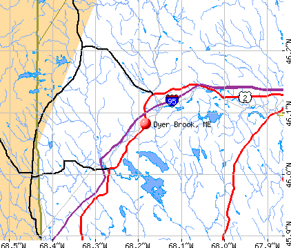
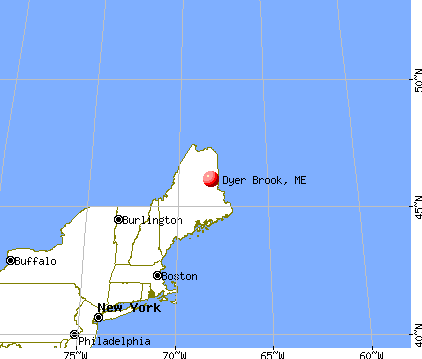
Dyer Brook, Maine
Submit your own pictures of this town and show them to the world
- OSM Map
- General Map
- Google Map
- MSN Map
Population change since 2000: +7.0%
 |
| Males: 101 | |
| Females: 112 |
| Median resident age: | 48.1 years |
| Maine median age: | 43.0 years |
Zip code: 04780
| Dyer Brook: | $82,748 |
| ME: | $69,543 |
Estimated per capita income in 2022: $38,506 (it was $18,658 in 2000)
Estimated median house or condo value in 2022: $187,646 (it was $77,500 in 2000)
| Dyer Brook: | $187,646 |
| ME: | $290,600 |
Mean prices in 2022: all housing units: $179,108; detached houses: $185,023; townhouses or other attached units: $218,327; in 2-unit structures: $262,505; in 3-to-4-unit structures: $121,406; in 5-or-more-unit structures: $185,084; mobile homes: $117,009; occupied boats, rvs, vans, etc.: $12,682
Detailed information about poverty and poor residents in Dyer Brook, ME


- 20998.1%White alone
- 31.4%American Indian alone
- 10.5%Black alone

According to our research of Maine and other state lists, there was 1 registered sex offender living in Dyer Brook, Maine as of May 23, 2024.
The ratio of all residents to sex offenders in Dyer Brook is 213 to 1.
 Recent articles from our blog. Our writers, many of them Ph.D. graduates or candidates, create easy-to-read articles on a wide variety of topics.

 | Maine weather thread (3207 replies) |
| Good driving distance from Houlton in winter? (10 replies) |
| A Bunch of Subversives in Central Maine (62 replies) |
| Coastal Mainers Vs. Rich Outsiders (53 replies) |
| maine north woods (146 replies) |
| Bargain -Unappreciated Maine towns - houses (59 replies) |
Latest news from Dyer Brook, ME collected exclusively by city-data.com from local newspapers, TV, and radio stations
Ancestries: English (40.7%), Irish (29.6%), French (12.1%), Scotch-Irish (11.1%), United States (7.5%), Scottish (7.0%).
Current Local Time: EST time zone
Incorporated on 03/21/1891
Elevation: 642 feet
Land area: 38.5 square miles.
Population density: 5.5 people per square mile (very low).
| Dyer Brook town: | 0.7% ($564) |
| Maine: | 1.5% ($1,417) |
Nearest city with pop. 50,000+: Portland, ME  (195.2 miles , pop. 64,249).
Nearest city with pop. 200,000+: Boston, MA (296.5 miles , pop. 589,141).
Nearest city with pop. 1,000,000+: Bronx, NY (460.0 miles , pop. 1,332,650).
Nearest cities:
), ), ), )Latitude: 46.08 N, Longitude: 68.21 W
Area code commonly used in this area: 207


Single-family new house construction building permits:
- 2017: 2 buildings, average cost: $105,000
- 2016: 1 building, cost: $55,000
- 2011: 1 building, cost: $100,000
- 2010: 1 building, cost: $165,900
- 2009: 1 building, cost: $105,600
- 2006: 2 buildings, average cost: $32,600
- 2005: 3 buildings, average cost: $83,700
- 2004: 2 buildings, average cost: $95,000
- 2003: 2 buildings, average cost: $42,500
- 2002: 2 buildings, average cost: $64,500
- 2001: 1 building, cost: $56,000
- 1998: 3 buildings, average cost: $86,000
- 1997: 2 buildings, average cost: $60,900


| Here: | 6.6% |
| Maine: | 3.4% |


- Educational services (30.1%)
- Agriculture, forestry, fishing & hunting (9.7%)
- Truck transportation (8.7%)
- Health care (8.7%)
- Wood products (6.8%)
- Construction (5.8%)
- Public administration (5.8%)

- Agriculture, forestry, fishing & hunting (19.2%)
- Truck transportation (17.3%)
- Wood products (13.5%)
- Construction (11.5%)
- Educational services (11.5%)
- Public administration (7.7%)
- Other transportation, support activities, couriers (7.7%)

- Educational services (49.0%)
- Health care (17.6%)
- Social assistance (11.8%)
- Department & other general merchandise stores (5.9%)
- Apparel (3.9%)
- Public administration (3.9%)
- Accommodation & food services (3.9%)

- Preschool, kindergarten, elementary, and middle school teachers (12.6%)
- Driver/sales workers and truck drivers (10.7%)
- Other management occupations, except farmers and farm managers (7.8%)
- Material recording, scheduling, dispatching, and distributing workers (5.8%)
- Other teachers, instructors, education, training, and library occupations (5.8%)
- Other food preparation and serving workers, including supervisors (5.8%)
- Bus drivers (3.9%)

- Driver/sales workers and truck drivers (21.2%)
- Preschool, kindergarten, elementary, and middle school teachers (11.5%)
- Material recording, scheduling, dispatching, and distributing workers (11.5%)
- Construction traders workers except carpenters, electricians, painters, plumbers, and construction laborers (7.7%)
- Art and design workers (5.8%)
- Top executives (3.8%)
- Law enforcement workers, including supervisors (3.8%)

- Preschool, kindergarten, elementary, and middle school teachers (13.7%)
- Other teachers, instructors, education, training, and library occupations (11.8%)
- Other management occupations, except farmers and farm managers (11.8%)
- Other food preparation and serving workers, including supervisors (11.8%)
- Nursing, psychiatric, and home health aides (7.8%)
- Bus drivers (7.8%)
- Other healthcare support occupations (5.9%)
Average climate in Dyer Brook, Maine
Based on data reported by over 4,000 weather stations


(lower is better)

Air Quality Index (AQI) level in 2017 was 46.0. This is significantly better than average.
| City: | 46.0 |
| U.S.: | 72.6 |

Particulate Matter (PM2.5) [µg/m3] level in 2017 was 5.39. This is significantly better than average. There were 0 monitors within city limits.
| City: | 5.39 |
| U.S.: | 8.11 |
Earthquake activity:
Dyer Brook-area historical earthquake activity is above Maine state average. It is 85% smaller than the overall U.S. average.On 4/20/2002 at 10:50:47, a magnitude 5.3 (5.3 ML, Depth: 3.0 mi, Class: Moderate, Intensity: VI - VII) earthquake occurred 288.0 miles away from Dyer Brook center
On 4/20/2002 at 10:50:47, a magnitude 5.2 (5.2 MB, 4.2 MS, 5.2 MW, 5.0 MW) earthquake occurred 289.7 miles away from Dyer Brook center
On 10/16/2012 at 23:12:25, a magnitude 4.7 (4.7 ML, Depth: 10.0 mi, Class: Light, Intensity: IV - V) earthquake occurred 209.5 miles away from the city center
On 7/14/2006 at 09:34:48, a magnitude 3.9 (3.9 MD, Depth: 8.6 mi, Class: Light, Intensity: II - III) earthquake occurred 59.4 miles away from the city center
On 10/7/1983 at 10:18:46, a magnitude 5.3 (5.1 MB, 5.3 LG, 5.1 ML) earthquake occurred 333.8 miles away from the city center
On 1/19/1982 at 00:14:42, a magnitude 4.7 (4.5 MB, 4.7 MD, 4.5 LG) earthquake occurred 243.9 miles away from Dyer Brook center
Magnitude types: regional Lg-wave magnitude (LG), body-wave magnitude (MB), duration magnitude (MD), local magnitude (ML), surface-wave magnitude (MS), moment magnitude (MW)
Natural disasters:
The number of natural disasters in Aroostook County (22) is greater than the US average (15).Major Disasters (Presidential) Declared: 13
Emergencies Declared: 9
Causes of natural disasters: Floods: 10, Storms: 8, Snows: 7, Heavy Rains: 2, Blizzard: 1, Hurricane: 1, Ice Storm: 1, Snowfall: 1, Snowstorm: 1, Wind: 1, Winter Storm: 1, Other: 2 (Note: some incidents may be assigned to more than one category).
Colleges/universities with over 2000 students nearest to Dyer Brook:
- University of Maine (about 85 miles; Orono, ME; Full-time enrollment: 8,931)
- Husson University (about 92 miles; Bangor, ME; FT enrollment: 2,421)
- University of Maine at Farmington (about 136 miles; Farmington, ME; FT enrollment: 2,036)
- University of Maine at Augusta (about 144 miles; Augusta, ME; FT enrollment: 3,204)
- Saint Joseph's College of Maine (about 192 miles; Standish, ME; FT enrollment: 2,010)
- Southern Maine Community College (about 196 miles; South Portland, ME; FT enrollment: 4,666)
- University of Southern Maine (about 196 miles; Portland, ME; FT enrollment: 6,647)
Public high school in Dyer Brook:
- SO AROOSTOOK SCHOOL (Location: 922 DYER BROOK ROAD, Grades: PK-12)
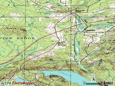
Points of interest:
Church in Dyer Brook: Dyer Brook Community Church (A). Display/hide its location on the map
Cemetery: Dyer Brook Cemetery (1). Display/hide its location on the map
Streams, rivers, and creeks: Bear Brook (A), Battle Brook (B). Display/hide their locations on the map
Birthplace of: Harold Drew - College football coach.
Drinking water stations with addresses in Dyer Brook and their reported violations in the past:
SOUTHERN AROOSTOOK COMM SCHOOL (Population served: 500, Groundwater):Past monitoring violations:RSU 50 KATAHDIN ELEMENTARY (Population served: 210, Groundwater):
- Follow-up Or Routine LCR Tap M/R - In JUL-01-1995, Contaminant: Lead and Copper Rule. Follow-up actions: St Public Notif requested (AUG-05-1996), St Public Notif received (MAR-24-2005), St Compliance achieved (MAR-12-2008)
- One routine major monitoring violation
- One regular monitoring violation
Past monitoring violations:
- 3 routine major monitoring violations
Drinking water stations with addresses in Dyer Brook that have no violations reported:
- RSU 50 KATAHDIN HIGH SCHOOL (Population served: 239, Primary Water Source Type: Groundwater)
| This town: | 2.3 people |
| Maine: | 2.3 people |
| This town: | 77.2% |
| Whole state: | 62.9% |
| This town: | 3.3% |
| Whole state: | 9.4% |
No gay or lesbian households reported
| This town: | 5.5% |
| Whole state: | 10.9% |
| This town: | 0.5% |
| Whole state: | 4.1% |
For population 15 years and over in Dyer Brook:

- Never married: 12.4%
- Now married: 74.1%
- Separated: 0.0%
- Widowed: 6.5%
- Divorced: 7.1%
For population 25 years and over in Dyer Brook:
- High school or higher: 84.8%
- Bachelor's degree or higher: 20.9%
- Graduate or professional degree: 8.9%
- Unemployed: 1.9%
- Mean travel time to work (commute): 32.7 minutes


| Here: | 10.3 |
| Maine average: | 11.2 |


Graphs represent county-level data. Detailed 2008 Election Results
Religion statistics for Dyer Brook, ME (based on Aroostook County data)


| Religion | Adherents | Congregations |
|---|---|---|
| Catholic | 22,200 | 27 |
| Mainline Protestant | 5,845 | 40 |
| Evangelical Protestant | 4,411 | 51 |
| Other | 957 | 7 |
| Orthodox | 10 | 1 |
| None | 38,447 | - |
Food Environment Statistics:
| Aroostook County: | 4.03 / 10,000 pop. |
| State: | 2.80 / 10,000 pop. |
| Aroostook County: | 0.14 / 10,000 pop. |
| State: | 0.14 / 10,000 pop. |
| Aroostook County: | 2.22 / 10,000 pop. |
| Maine: | 2.20 / 10,000 pop. |
| This county: | 7.78 / 10,000 pop. |
| Maine: | 5.75 / 10,000 pop. |
| Here: | 9.17 / 10,000 pop. |
| State: | 11.02 / 10,000 pop. |
| Aroostook County: | 11.7% |
| State: | 8.2% |
| This county: | 27.6% |
| Maine: | 25.0% |
Strongest AM radio stations in Dyer Brook:
- WREM (710 AM; daytime; 5 kW; MONTICELLO, ME; Owner: ALLAN H WEINER)
- WFST (600 AM; 5 kW; CARIBOU, ME; Owner: NORTHERN BROADCAST MINISTRIES, INC.)
- WEGP (1390 AM; 5 kW; PRESQUE ISLE, ME; Owner: DECELLES/SMITH MEDIA, INC.)
- WZON (620 AM; 5 kW; BANGOR, ME; Owner: THE ZONE CORPORATION)
- WRKO (680 AM; 50 kW; BOSTON, MA; Owner: ENTERCOM BOSTON LICENSE, LLC)
- WCHP (760 AM; 35 kW; CHAMPLAIN, NY; Owner: CHAMPLAIN RADIO, INC.)
- WSKW (1160 AM; 10 kW; SKOWHEGAN, ME; Owner: MOUNTAIN WIRELESS, INCORPORATED)
- WEEI (850 AM; 50 kW; BOSTON, MA; Owner: ENTERCOM BOSTON LICENSE, LLC)
- WABI (910 AM; 5 kW; BANGOR, ME; Owner: CLEAR CHANNEL BROADCASTING LICENSES, INC.)
- WNNZ (640 AM; 50 kW; WESTFIELD, MA; Owner: CLEAR CHANNEL BROADCASTING LICENSES, INC.)
- WSYY (1240 AM; 1 kW; MILLINOCKET, ME; Owner: KATAHDIN BROADCASTING, INC.)
- WCRN (830 AM; 50 kW; WORCESTER, MA; Owner: CARTER BROADCASTING CORPORATION)
- WBZ (1030 AM; 50 kW; BOSTON, MA; Owner: INFINITY BROADCASTING OPERATIONS, INC.)
Strongest FM radio stations in Dyer Brook:
- WHOU-FM (100.1 FM; HOULTON, ME; Owner: COUNTY COMMUNICATIONS, INC.)
- WQHR (96.1 FM; PRESQUE ISLE, ME; Owner: CITADEL BROADCASTING COMPANY)
- WOZI (101.9 FM; PRESQUE ISLE, ME; Owner: CITADEL BROADCASTING COMPANY)
- WMEM (106.1 FM; PRESQUE ISLE, ME; Owner: MAINE PUBLIC BROADCASTING CORPORATION)
- WBPW (96.9 FM; PRESQUE ISLE, ME; Owner: CITADEL BROADCASTING COMPANY)
Dyer Brook fatal accident list:
Dec 15, 2009 09:00 AM, Sr-2, Lat: 46.038328, Lon: -68.228703, Vehicles: 2, Persons: 2, Fatalities: 1
Jun 9, 2006 09:14 PM, I-95nb, Lat: 46.135200, Lon: -68.082890, Vehicles: 1, Persons: 2, Fatalities: 1
- National Bridge Inventory (NBI) Statistics
- 5Number of bridges
- 69ft / 20.9mTotal length
- 6,630Total average daily traffic
- 331Total average daily truck traffic
- 9,618Total future (year 2036) average daily traffic
FCC Registered Broadcast Land Mobile Towers:
1- Lat: 46.081389 Lon: -68.182778, Call Sign: WQFG213,
Assigned Frequencies: 151.595 MHz, Grant Date: 06/21/2016, Expiration Date: 07/06/2026, Certifier: Herb Hardy, Registrant: Business Radio Licensing, 30251 Golden Lantern, Suite E# 501, Laguna Niguel, CA 92677, Phone: (949) 348-8510, Fax: (949) 348-8514, Email:
FCC Registered Amateur Radio Licenses:
2- Call Sign: WA1PLZ, Licensee ID: L00651960, Grant Date: 10/24/2014, Expiration Date: 01/10/2025, Certifier: Anthony Gillotti, Registrant: Anthony Gillotti, 1244 Dyer Brook Road, Dyer Brook, ME 04747
- Call Sign: WA1ZDL, Licensee ID: L00928114, Grant Date: 10/30/2014, Expiration Date: 01/10/2025, Certifier: Timothy P Gillotti, Registrant: Timothy P Gillotti, 1244 Dyer Brook Road, Dyer Brook, ME 04747-5031

- 59.2%Fuel oil, kerosene, etc.
- 40.8%Wood

- 62.5%Wood
- 37.5%Fuel oil, kerosene, etc.
Dyer Brook compared to Maine state average:
- Median house value below state average.
- Unemployed percentage significantly below state average.
- Black race population percentage significantly below state average.
- Hispanic race population percentage significantly below state average.
- Median age above state average.
- Foreign-born population percentage significantly below state average.
- Renting percentage significantly below state average.
- Length of stay since moving in significantly above state average.
- Number of rooms per house significantly below state average.
- House age significantly below state average.