Hunter, Wisconsin
Submit your own pictures of this town and show them to the world
- OSM Map
- Google Map
- MSN Map
Population change since 2000: -11.4%
 |
| Males: 346 | |
| Females: 332 |
| Median resident age: | 51.1 years |
| Wisconsin median age: | 42.6 years |
Zip codes: 54843.
| Hunter: | $52,729 |
| WI: | $70,996 |
Estimated per capita income in 2022: $33,498 (it was $16,309 in 2000)
Hunter town income, earnings, and wages data
Estimated median house or condo value in 2022: $303,370 (it was $122,700 in 2000)
| Hunter: | $303,370 |
| WI: | $252,800 |
Mean prices in 2022: all housing units: $277,850; detached houses: $285,245; townhouses or other attached units: $272,338; in 2-unit structures: $289,555; in 3-to-4-unit structures: $295,924; mobile homes: $105,132; occupied boats, rvs, vans, etc.: $24,097
Detailed information about poverty and poor residents in Hunter, WI
Compare current foreclosures near Hunter, WI:
| Photo | Address | Area | Beds / Baths | Price | Details |
|---|---|---|---|---|---|

|
#1
N South Reserve Rd
Stone Lake, WI 54876
|
- sq. feet
|
- baths - beds |
show details | |

|
#2
N Clark St
Radisson, WI 54867
|
- sq. feet
|
- baths - beds |
show details | |

|
#3
N Lake Winter Rd
Winter, WI 54896
|
- sq. feet
|
- baths - beds |
show details | |

|
#4
W Pfister Rd
Hayward, WI 54843
|
- sq. feet
|
- baths - beds |
show details | |

|
#5
Salter Dr Lot 32
Hayward, WI 54843
|
- sq. feet
|
- baths - beds |
show details | |

|
#6
Pinewood Dr Lot 59
Hayward, WI 54843
|
- sq. feet
|
- baths - beds |
show details | |

|
#7
E 3rd St
Hayward, WI 54843
|
- sq. feet
|
- baths - beds |
show details | |

|
#8
Beal Ave Apt 4w
Hayward, WI 54843
|
- sq. feet
|
- baths - beds |
show details | |

|
#9
Beal Ave
Hayward, WI 54843
|
- sq. feet
|
- baths - beds |
show details | |

|
#10
Wisconsin
Hayward, WI 54843
|
- sq. feet
|
- baths - beds |
show details |
| Photo | Address | Area | Beds / Baths | Price | Details |
|---|---|---|---|---|---|

|
#11
W South Shore Rd
Hayward, WI 54843
|
- sq. feet
|
- baths - beds |
show details | |

|
#12
N Weirgor Rd
Radisson, WI 54867
|
- sq. feet
|
- baths - beds |
show details | |

|
#13
N Gouch Circle Rd
Hayward, WI 54843
|
- sq. feet
|
- baths - beds |
show details | |

|
#14
N Stone Hill Rd
Hayward, WI 54843
|
- sq. feet
|
- baths - beds |
show details | |

|
Check over 1 million property listings on Foreclosure.com!
|
browse all offers | |||

- 40960.3%White alone
- 24736.4%American Indian alone
- 111.6%Two or more races
- 111.6%Hispanic

Races in Hunter detailed stats: ancestries, foreign born residents, place of birth
 Recent articles from our blog. Our writers, many of them Ph.D. graduates or candidates, create easy-to-read articles on a wide variety of topics.
Ancestries: German (26.7%), Irish (14.0%), Polish (9.2%), English (6.0%), Norwegian (4.1%), Swedish (3.4%).
Current Local Time: CST time zone
Land area: 52.1 square miles.
Population density: 13 people per square mile (very low).
13 residents are foreign born
| This town: | 1.7% |
| Wisconsin: | 3.6% |
| Hunter town: | 1.2% ($1,516) |
| Wisconsin: | 2.0% ($2,245) |
Nearest city with pop. 50,000+: Duluth, MN  (73.8 miles , pop. 86,918).
Nearest city with pop. 200,000+: St. Paul, MN (116.0 miles , pop. 287,151).
Nearest city with pop. 1,000,000+: Chicago, IL (332.4 miles , pop. 2,896,016).
Nearest cities:
), ), ), ), )Latitude: 45.94 N, Longitude: 91.17 W
Area code commonly used in this area: 715

| Here: | 4.5% |
| Wisconsin: | 2.7% |

- Accommodation & food services (14.3%)
- Construction (10.0%)
- Arts, entertainment, recreation (8.0%)
- Educational services (7.4%)
- Public administration (7.4%)
- Metal & metal products (6.6%)
- Health care (5.7%)

- Construction (16.7%)
- Accommodation & food services (13.0%)
- Metal & metal products (10.4%)
- Public administration (9.9%)
- Arts, entertainment, recreation (8.9%)
- Agriculture, forestry, fishing & hunting (5.7%)
- Administrative & support & waste management services (5.7%)

- Accommodation & food services (15.8%)
- Educational services (13.3%)
- Health care (8.9%)
- Food & beverage stores (8.2%)
- Professional, scientific, technical services (7.0%)
- Arts, entertainment, recreation (7.0%)
- Finance & insurance (6.3%)

- Other management occupations, except farmers and farm managers (8.9%)
- Building and grounds cleaning and maintenance occupations (6.6%)
- Cashiers (5.1%)
- Metal workers and plastic workers (4.3%)
- Preschool, kindergarten, elementary, and middle school teachers (3.7%)
- Other office and administrative support workers, including supervisors (3.7%)
- Information and record clerks, except customer service representatives (3.4%)

- Other management occupations, except farmers and farm managers (12.0%)
- Building and grounds cleaning and maintenance occupations (10.4%)
- Metal workers and plastic workers (7.8%)
- Sales representatives, services, wholesale and manufacturing (3.6%)
- Electrical equipment mechanics and other installation, maintenance, and repair workers, including supervisors (3.1%)
- Other protective service workers, including supervisors (3.1%)
- Cooks and food preparation workers (3.1%)

- Cashiers (9.5%)
- Other office and administrative support workers, including supervisors (7.0%)
- Preschool, kindergarten, elementary, and middle school teachers (6.3%)
- Counselors, social workers, and other community and social service specialists (6.3%)
- Information and record clerks, except customer service representatives (5.7%)
- Bookkeeping, accounting, and auditing clerks (5.7%)
- Other management occupations, except farmers and farm managers (5.1%)
Average climate in Hunter, Wisconsin
Based on data reported by over 4,000 weather stations


Tornado activity:
Hunter-area historical tornado activity is significantly below Wisconsin state average. It is 45% smaller than the overall U.S. average.
On 7/30/1977, a category F4 (max. wind speeds 207-260 mph) tornado 46.1 miles away from the Hunter town center injured 20 people and caused between $5,000,000 and $50,000,000 in damages.
On 5/10/1953, a category F4 tornado 47.3 miles away from the town center killed 2 people and injured 24 people.
Earthquake activity:
Hunter-area historical earthquake activity is significantly above Wisconsin state average. It is 71% smaller than the overall U.S. average.On 7/9/1975 at 14:54:15, a magnitude 4.6 (4.6 MB, Class: Light, Intensity: IV - V) earthquake occurred 235.4 miles away from the city center
On 6/5/1993 at 01:24:53, a magnitude 4.1 (4.1 LG, Depth: 6.2 mi) earthquake occurred 247.4 miles away from Hunter center
On 2/7/2020 at 18:30:28, a magnitude 3.3 (3.3 ML, Class: Light, Intensity: II - III) earthquake occurred 129.6 miles away from Hunter center
On 1/9/2020 at 18:16:48, a magnitude 3.3 (3.3 MB) earthquake occurred 132.4 miles away from Hunter center
On 4/8/2020 at 17:14:33, a magnitude 3.3 (3.3 ML) earthquake occurred 132.7 miles away from the city center
On 3/2/2017 at 16:53:31, a magnitude 3.2 (3.2 ML) earthquake occurred 123.0 miles away from the city center
Magnitude types: regional Lg-wave magnitude (LG), body-wave magnitude (MB), local magnitude (ML)
Natural disasters:
The number of natural disasters in Sawyer County (8) is smaller than the US average (15).Major Disasters (Presidential) Declared: 5
Emergencies Declared: 3
Causes of natural disasters: Floods: 4, Storms: 4, Tornadoes: 2, Winds: 2, Drought: 1, Hurricane: 1, Other: 1 (Note: some incidents may be assigned to more than one category).
Colleges/universities with over 2000 students nearest to Hunter:
- Wisconsin Indianhead Technical College (about 39 miles; Shell Lake, WI; Full-time enrollment: 2,414)
- University of Wisconsin-Superior (about 70 miles; Superior, WI; FT enrollment: 2,302)
- Lake Superior College (about 75 miles; Duluth, MN; FT enrollment: 3,768)
- University of Minnesota-Duluth (about 75 miles; Duluth, MN; FT enrollment: 10,612)
- The College of Saint Scholastica (about 76 miles; Duluth, MN; FT enrollment: 3,762)
- University of Wisconsin-Eau Claire (about 81 miles; Eau Claire, WI; FT enrollment: 10,143)
- Chippewa Valley Technical College (about 81 miles; Eau Claire, WI; FT enrollment: 4,038)
Points of interest:
Notable locations in Hunter: Hermans Landing (A), Blueberry Campground (B), Hunter Townhall (C), Lac Courte Oreilles Volunteer Fire Department Station 1 (D). Display/hide their locations on the map
Lakes and reservoirs: Pine Island Lake (A), Pokegama Lake (B), Reed Lake (C), Rice Lake (D), Scott Lake (E), Two Axe Lake (F), Two Boys Lake (G), Venison Lake (H). Display/hide their locations on the map
Rivers and creeks: Venison Creek (A), Yankee Joe Creek (B), Weasel Creek (C), West Fork Chippewa River (D), Hay Creek (E), East Fork Chippewa River (F), Drake Creek (G), Beaver Lake Creek (H), Beaver Creek (I). Display/hide their locations on the map
| This town: | 2.2 people |
| Wisconsin: | 2.4 people |
| This town: | 65.3% |
| Whole state: | 64.4% |
| This town: | 8.1% |
| Whole state: | 7.3% |
Likely homosexual households (counted as self-reported same-sex unmarried-partner households)
- Lesbian couples: 0.0% of all households
- Gay men: 1.0% of all households
| This town: | 14.9% |
| Whole state: | 8.7% |
| This town: | 8.0% |
| Whole state: | 3.7% |
For population 15 years and over in Hunter:

- Never married: 20.6%
- Now married: 55.8%
- Separated: 1.5%
- Widowed: 8.5%
- Divorced: 13.6%
For population 25 years and over in Hunter:
- High school or higher: 83.4%
- Bachelor's degree or higher: 9.3%
- Graduate or professional degree: 2.9%
- Unemployed: 1.7%
- Mean travel time to work (commute): 18.9 minutes


| Here: | 8.4 |
| Wisconsin average: | 11.0 |
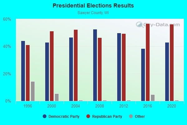
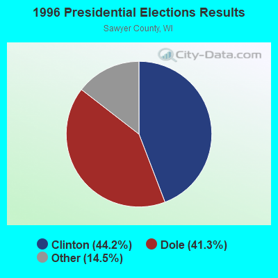
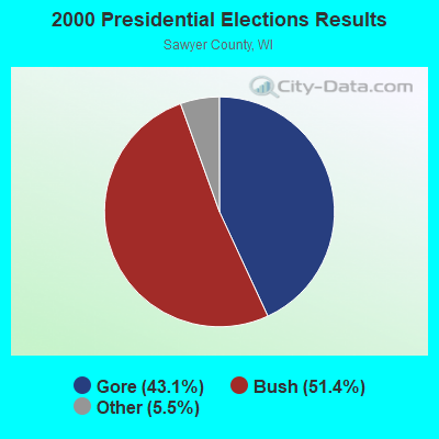
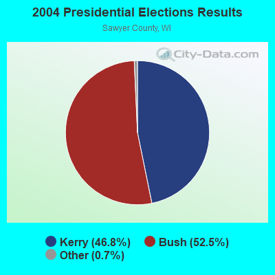
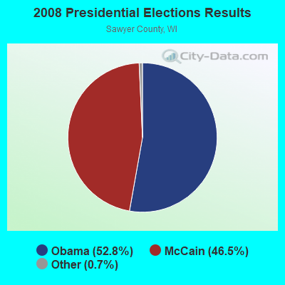
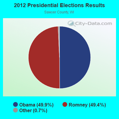
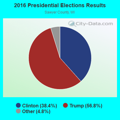
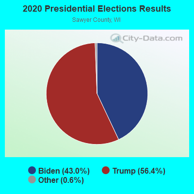
Graphs represent county-level data. Detailed 2008 Election Results
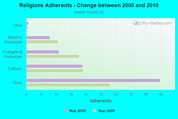
Religion statistics for Hunter, WI (based on Sawyer County data)
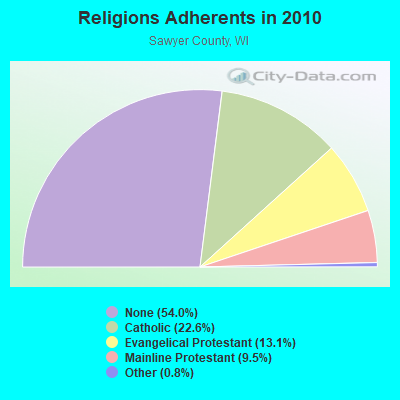
| Religion | Adherents | Congregations |
|---|---|---|
| Catholic | 3,747 | 6 |
| Evangelical Protestant | 2,162 | 18 |
| Mainline Protestant | 1,568 | 11 |
| Other | 136 | 2 |
| None | 8,944 | - |
Food Environment Statistics:
| Sawyer County: | 2.93 / 10,000 pop. |
| State: | 1.86 / 10,000 pop. |
| Here: | 0.59 / 10,000 pop. |
| Wisconsin: | 0.11 / 10,000 pop. |
| Sawyer County: | 1.17 / 10,000 pop. |
| Wisconsin: | 0.38 / 10,000 pop. |
| Sawyer County: | 9.96 / 10,000 pop. |
| Wisconsin: | 4.12 / 10,000 pop. |
| Sawyer County: | 27.54 / 10,000 pop. |
| State: | 8.64 / 10,000 pop. |
| This county: | 9.2% |
| State: | 7.6% |
| Sawyer County: | 28.1% |
| State: | 27.5% |
| Sawyer County: | 15.2% |
| Wisconsin: | 13.0% |
Strongest AM radio stations in Hunter:
- WEBC (560 AM; 50 kW; DULUTH, MN)
- WHSM (910 AM; 5 kW; HAYWARD, WI; Owner: QB BROADCASTING, LTD.)
- WCCO (830 AM; 50 kW; MINNEAPOLIS, MN; Owner: INFINITY MEDIA CORPORATION)
- WCTS (1030 AM; 50 kW; MAPLEWOOD, MN; Owner: CNTL. BAPT. THEO/AL SEMI MINNEAPOLIS)
- WSPT (1010 AM; 50 kW; STEVENS POINT, WI)
- WAQE (1090 AM; daytime; 5 kW; RICE LAKE, WI; Owner: TKC, INC.)
- WSAU (550 AM; 20 kW; WAUSAU, WI; Owner: WRIG, INC.)
- WDSM (710 AM; 10 kW; SUPERIOR, WI; Owner: MIDWEST COMMUNICATIONS, INC.)
- KSTP (1500 AM; 50 kW; ST. PAUL, MN; Owner: KSTP-AM, LLC (DELAWARE))
- WJMS (590 AM; 5 kW; IRONWOOD, MI; Owner: ROBERTS BROADCASTING, INC.)
- WWJC (850 AM; daytime; 10 kW; DULUTH, MN; Owner: WWJC, INC.)
- KTIS (900 AM; 25 kW; MINNEAPOLIS, MN; Owner: NORTHWESTERN COLLEGE)
- KFAN (1130 AM; 50 kW; MINNEAPOLIS, MN; Owner: AMFM RADIO LICENSES, L.L.C.)
Strongest FM radio stations in Hunter:
- WOJB (88.9 FM; RESERVE, WI; Owner: LAC COURTE OREILLES OJIBWA PUBLIC)
- WHSM-FM (101.1 FM; HAYWARD, WI; Owner: QB BROADCASTING, LTD.)
- WRLS-FM (92.3 FM; HAYWARD, WI; Owner: VACATIONLAND BROADCASTER, INC.)
TV broadcast stations around Hunter:
- WLEF-TV (Channel 36; PARK FALLS, WI; Owner: STATE OF WISCONSIN - EDUCATIONAL COMMUNICATIONS BOARD)
- K31GH (Channel 31; HAYWARD, WI; Owner: KQDS ACQUISITION CORP.)
- National Bridge Inventory (NBI) Statistics
- 4Number of bridges
- 46ft / 13.6mTotal length
- $392,000Total costs
- 3,309Total average daily traffic
- 223Total average daily truck traffic
- 4,004Total future (year 2039) average daily traffic
FCC Registered Broadcast Land Mobile Towers:
1- Woodland Dr Rd (Lat: 45.933278 Lon: -91.183500), Call Sign: KNFD931, Licensee ID: L00116882,
Assigned Frequencies: 151.775 MHz, Grant Date: 01/22/1997, Expiration Date: 03/31/2002, Cancellation Date: 06/02/2002, Registrant: Geddeis Insurance Agency Inc, Rt 9, Hayward, WI 54843, Phone: (715) 462-3288

- 73.9%Bottled, tank, or LP gas
- 12.9%Wood
- 9.9%Electricity
- 1.5%Other fuel
- 1.1%Fuel oil, kerosene, etc.
- 0.7%Utility gas

- 78.1%Bottled, tank, or LP gas
- 12.3%Utility gas
- 4.1%Wood
- 2.7%Fuel oil, kerosene, etc.
- 2.7%Other fuel
Hunter compared to Wisconsin state average:
- Unemployed percentage significantly below state average.
- Black race population percentage significantly below state average.
- Hispanic race population percentage significantly below state average.
- Median age significantly above state average.
- Foreign-born population percentage significantly below state average.
- Renting percentage below state average.
- Length of stay since moving in significantly above state average.
- Number of rooms per house significantly below state average.
- House age significantly below state average.
- Percentage of population with a bachelor's degree or higher significantly below state average.