Kensett, Arkansas
Submit your own pictures of this city and show them to the world
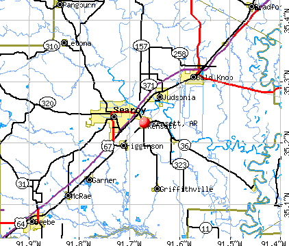
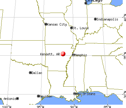
- OSM Map
- General Map
- Google Map
- MSN Map
Population change since 2000: -21.2%
 |
| Males: 700 | |
| Females: 712 |
| Median resident age: | 37.4 years |
| Arkansas median age: | 38.9 years |
Zip codes: 72082.
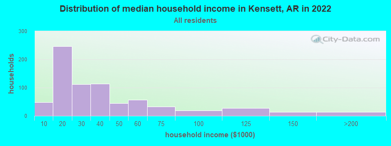
| Kensett: | $31,465 |
| AR: | $55,432 |
Estimated per capita income in 2022: $16,094 (it was $11,049 in 2000)
Kensett city income, earnings, and wages data
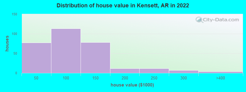
Estimated median house or condo value in 2022: $85,802 (it was $36,200 in 2000)
| Kensett: | $85,802 |
| AR: | $179,800 |
Mean prices in 2022: all housing units: $83,803; detached houses: $92,837; mobile homes: $31,543
Median gross rent in 2022: $705.
(29.4% for White Non-Hispanic residents, 7.6% for Black residents, 66.2% for Hispanic or Latino residents, 16.1% for two or more races residents)
Detailed information about poverty and poor residents in Kensett, AR
Compare current foreclosures near Kensett, AR:
| Photo | Address | Area | Beds / Baths | Price | Details |
|---|---|---|---|---|---|

|
#1
Doniphan St # 9
Kensett, AR 72082
|
- sq. feet
|
- baths - beds |
show details | |

|
#2
Central St
Kensett, AR 72082
|
- sq. feet
|
- baths - beds |
show details | |

|
#3
Missile Base Rd
Judsonia, AR 72081
|
2,266 sq. feet
|
2 baths 3 beds |
show details | |

|
#4
Whippoorwill Dr
Searcy, AR 72143
|
1,572 sq. feet
|
2 baths 3 beds |
show details | |

|
#5
Julner Dr
Searcy, AR 72143
|
1,736 sq. feet
|
2 baths 3 beds |
show details | |

|
#6
N Main St
Beebe, AR 72012
|
1,230 sq. feet
|
2 baths 3 beds |
show details | |

|
#7
E Center St
Beebe, AR 72012
|
1,112 sq. feet
|
1 baths 3 beds |
show details | |

|
#8
Sibley Trl
Searcy, AR 72143
|
1,970 sq. feet
|
3 baths 3 beds |
show details | |

|
#9
Smith Rd
Searcy, AR 72143
|
1,842 sq. feet
|
3 baths 4 beds |
show details | |

|
#10
Billy Davis Dr
Searcy, AR 72143
|
2,345 sq. feet
|
3 baths 4 beds |
show details |
| Photo | Address | Area | Beds / Baths | Price | Details |
|---|---|---|---|---|---|

|
#11
W Woodruff Ave
Searcy, AR 72143
|
- sq. feet
|
- baths - beds |
$54,900
|
show details |

|
#12
Crestview Dr
Pangburn, AR 72121
|
2 sq. feet
|
2 baths 3 beds |
show details | |

|
#13
Collins Rd
Searcy, AR 72143
|
1,963 sq. feet
|
2 baths - beds |
show details | |

|
#14
Koa Rd
Searcy, AR 72143
|
860 sq. feet
|
1 baths - beds |
show details | |

|
#15
Brookhaven Rd
Searcy, AR 72143
|
1,300 sq. feet
|
1 baths - beds |
show details | |

|
#16
W Country Club Rd
Searcy, AR 72143
|
1,815 sq. feet
|
2 baths - beds |
show details | |

|
#17
Clara St
Searcy, AR 72143
|
1,895 sq. feet
|
2 baths - beds |
show details | |

|
#18
Missile Base Rd
Judsonia, AR 72081
|
1,650 sq. feet
|
2 baths - beds |
show details | |

|
#19
Walmsley Rd
Bald Knob, AR 72010
|
888 sq. feet
|
1 baths - beds |
show details | |

|
#20
Country Squire Ln
Searcy, AR 72143
|
997 sq. feet
|
2 baths - beds |
show details |
| Photo | Address | Area | Beds / Baths | Price | Details |
|---|---|---|---|---|---|

|
#21
Audley Bolton Dr
Searcy, AR 72143
|
1,845 sq. feet
|
2 baths - beds |
show details | |

|
#22
Sherwood Loop
Searcy, AR 72143
|
1,346 sq. feet
|
2 baths - beds |
show details | |

|
#23
Hartwell Pl
Searcy, AR 72143
|
1,122 sq. feet
|
1 baths - beds |
show details | |

|
#24
Fernhill Pl
Searcy, AR 72143
|
1,335 sq. feet
|
1 baths - beds |
show details | |

|
#25
White Oak Dr
Judsonia, AR 72081
|
1,302 sq. feet
|
2 baths - beds |
show details | |

|
#26
Deer Ridge Dr
Searcy, AR 72143
|
1,379 sq. feet
|
2 baths - beds |
show details | |

|
#27
Richardson St
Bald Knob, AR 72010
|
1,040 sq. feet
|
1 baths - beds |
show details | |

|
#28
W Vinity Rd
Mc Rae, AR 72102
|
2,356 sq. feet
|
1 baths - beds |
show details | |

|
#29
Baker St
Beebe, AR 72012
|
1,216 sq. feet
|
1 baths - beds |
show details | |

|
#30
S Fir St
Beebe, AR 72012
|
1,568 sq. feet
|
1 baths - beds |
show details |
| Photo | Address | Area | Beds / Baths | Price | Details |
|---|---|---|---|---|---|

|
#31
W College St
Beebe, AR 72012
|
1,216 sq. feet
|
1 baths - beds |
show details | |

|
#32
N Hickory St
Beebe, AR 72012
|
2,068 sq. feet
|
3 baths - beds |
show details | |

|
#33
Peacock Rd
Bradford, AR 72020
|
2,365 sq. feet
|
2 baths - beds |
show details | |

|
#34
Laura Ln
Searcy, AR 72143
|
1,400 sq. feet
|
2 baths - beds |
show details | |

|
#35
Glaze Mason Rd
Bald Knob, AR 72010
|
2,356 sq. feet
|
2 baths - beds |
show details | |

|
#36
E 2nd St
Mc Rae, AR 72102
|
1,400 sq. feet
|
1 baths - beds |
show details | |

|
#37
Highway 258
Bald Knob, AR 72010
|
2,370 sq. feet
|
2 baths - beds |
show details | |

|
#38
N Grand Ave
Mc Rae, AR 72102
|
1,379 sq. feet
|
1 baths - beds |
show details | |

|
#39
16th Section Rd
Mc Rae, AR 72102
|
1,680 sq. feet
|
1 baths - beds |
show details | |

|
#40
Mount Moriah Dr
Mc Rae, AR 72102
|
3,552 sq. feet
|
2 baths - beds |
show details |
| Photo | Address | Area | Beds / Baths | Price | Details |
|---|---|---|---|---|---|

|
#41
Pumping Station Rd
Bald Knob, AR 72010
|
1,776 sq. feet
|
1 baths - beds |
show details | |

|
#42
Old Russell Rd
Bald Knob, AR 72010
|
784 sq. feet
|
1 baths - beds |
show details | |

|
#43
W Highway 36
Searcy, AR 72143
|
800 sq. feet
|
1 baths - beds |
show details | |

|
#44
Graham Rd
Judsonia, AR 72081
|
1,624 sq. feet
|
2 baths - beds |
show details | |

|
#45
Lynwood Dr
Searcy, AR 72143
|
1,626 sq. feet
|
2 baths - beds |
show details | |

|
#46
May St
Bald Knob, AR 72010
|
1,421 sq. feet
|
1 baths - beds |
show details | |

|
#47
Vineyard Pl
Searcy, AR 72143
|
1,624 sq. feet
|
2 baths - beds |
show details | |

|
#48
Meadow Lark Ln
Judsonia, AR 72081
|
1,276 sq. feet
|
1 baths - beds |
show details | |

|
#49
N Oak St
Searcy, AR 72143
|
1,260 sq. feet
|
1 baths - beds |
show details | |

|
Check over 1 million property listings on Foreclosure.com!
|
browse all offers | |||


- 1,19958.2%White alone
- 36117.5%Black alone
- 29514.3%Hispanic
- 26512.9%Two or more races

According to our research of Arkansas and other state lists, there were 5 registered sex offenders living in Kensett, Arkansas as of May 23, 2024.
The ratio of all residents to sex offenders in Kensett is 314 to 1.
Type |
2009 |
2010 |
2011 |
2012 |
2013 |
2014 |
2015 |
2016 |
2017 |
2018 |
2019 |
2020 |
2022 |
|---|---|---|---|---|---|---|---|---|---|---|---|---|---|
| Murders (per 100,000) | 0 (0.0) | 0 (0.0) | 0 (0.0) | 0 (0.0) | 0 (0.0) | 0 (0.0) | 0 (0.0) | 0 (0.0) | 1 (60.7) | 0 (0.0) | 0 (0.0) | 1 (62.0) | 0 (0.0) |
| Rapes (per 100,000) | 0 (0.0) | 0 (0.0) | 0 (0.0) | 1 (59.6) | 0 (0.0) | 3 (180.2) | 2 (121.6) | 3 (181.8) | 0 (0.0) | 1 (61.4) | 1 (61.8) | 1 (62.0) | 2 (143.3) |
| Robberies (per 100,000) | 1 (54.0) | 0 (0.0) | 0 (0.0) | 0 (0.0) | 1 (59.5) | 0 (0.0) | 0 (0.0) | 0 (0.0) | 1 (60.7) | 0 (0.0) | 0 (0.0) | 1 (62.0) | 0 (0.0) |
| Assaults (per 100,000) | 3 (162.0) | 3 (182.0) | 4 (241.0) | 4 (238.4) | 2 (118.9) | 3 (180.2) | 2 (121.6) | 2 (121.2) | 1 (60.7) | 2 (122.8) | 6 (370.8) | 6 (372.0) | 0 (0.0) |
| Burglaries (per 100,000) | 18 (971.9) | 7 (424.8) | 8 (481.9) | 10 (595.9) | 16 (951.2) | 5 (300.3) | 6 (364.7) | 2 (121.2) | 5 (303.6) | 5 (306.9) | 3 (185.4) | 7 (434.0) | 2 (143.3) |
| Thefts (per 100,000) | 20 (1,080) | 13 (788.8) | 22 (1,325) | 24 (1,430) | 31 (1,843) | 29 (1,742) | 26 (1,581) | 32 (1,939) | 14 (850.0) | 22 (1,351) | 14 (865.3) | 16 (991.9) | 15 (1,074) |
| Auto thefts (per 100,000) | 7 (378.0) | 5 (303.4) | 2 (120.5) | 4 (238.4) | 4 (237.8) | 1 (60.1) | 1 (60.8) | 1 (60.6) | 2 (121.4) | 3 (184.2) | 1 (61.8) | 0 (0.0) | 1 (71.6) |
| Arson (per 100,000) | 0 (0.0) | 1 (60.7) | 0 (0.0) | 0 (0.0) | 0 (0.0) | 0 (0.0) | 0 (0.0) | 0 (0.0) | 0 (0.0) | 0 (0.0) | 1 (61.8) | 2 (124.0) | 0 (0.0) |
| City-Data.com crime index | 190.1 | 122.0 | 144.6 | 213.3 | 201.0 | 275.7 | 215.2 | 260.6 | 216.8 | 163.9 | 176.1 | 336.6 | 173.4 |
The City-Data.com crime index weighs serious crimes and violent crimes more heavily. Higher means more crime, U.S. average is 246.1. It adjusts for the number of visitors and daily workers commuting into cities.

Crime rate in Kensett detailed stats: murders, rapes, robberies, assaults, burglaries, thefts, arson
Full-time law enforcement employees in 2021, including police officers: 5 (4 officers - 3 male; 1 female).
| Officers per 1,000 residents here: | 2.48 |
| Arkansas average: | 2.25 |
 Recent articles from our blog. Our writers, many of them Ph.D. graduates or candidates, create easy-to-read articles on a wide variety of topics.

 | Is Arkansas welcome of outsiders? (44 replies) |
| Looking for 1/2 siblings (1 reply) |
Latest news from Kensett, AR collected exclusively by city-data.com from local newspapers, TV, and radio stations
Ancestries: English (14.8%), American (12.3%), Irish (7.7%), German (2.0%).
Current Local Time: CST time zone
Incorporated on 10/16/1911
Elevation: 223 feet
Land area: 1.78 square miles.
Population density: 795 people per square mile (low).
155 residents are foreign born (7.2% Latin America).
| This city: | 7.5% |
| Arkansas: | 5.0% |
| Kensett city: | 0.8% ($289) |
| Arkansas: | 0.7% ($500) |
Nearest city with pop. 50,000+: North Little Rock, AR  (45.6 miles , pop. 60,433).
Nearest city with pop. 200,000+: Memphis, TN (96.4 miles , pop. 650,100).
Nearest city with pop. 1,000,000+: Dallas, TX (338.1 miles , pop. 1,188,580).
Nearest cities:
), ), ), ), )Latitude: 35.23 N, Longitude: 91.67 W
Area code: 501

Single-family new house construction building permits:
- 2022: 3 buildings, average cost: $166,700
- 2021: 3 buildings, average cost: $183,300
- 2012: 1 building, cost: $120,000
- 2011: 9 buildings, average cost: $67,600
- 2009: 6 buildings, average cost: $51,700
- 2008: 8 buildings, average cost: $100,000
- 2004: 1 building, cost: $90,000
- 2003: 1 building, cost: $90,000
- 1999: 1 building, cost: $40,000
- 1998: 1 building, cost: $75,000


| Here: | 3.6% |
| Arkansas: | 3.4% |

- Construction (9.1%)
- Department & other general merchandise stores (8.2%)
- Health care (8.0%)
- Food (8.0%)
- Accommodation & food services (6.2%)
- Wood products (4.6%)
- Electrical equipment, appliances, components (4.5%)

- Construction (14.7%)
- Food (8.8%)
- Wood products (7.7%)
- Department & other general merchandise stores (5.6%)
- Truck transportation (5.6%)
- Electrical equipment, appliances, components (5.1%)
- Agriculture, forestry, fishing & hunting (4.5%)

- Health care (16.1%)
- Department & other general merchandise stores (11.4%)
- Accommodation & food services (9.0%)
- Educational services (7.4%)
- Food (7.0%)
- Transportation equipment (4.3%)
- Administrative & support & waste management services (4.3%)

- Other production occupations, including supervisors (12.2%)
- Laborers and material movers, hand (7.3%)
- Metal workers and plastic workers (5.5%)
- Building and grounds cleaning and maintenance occupations (4.9%)
- Electrical equipment mechanics and other installation, maintenance, and repair workers, including supervisors (4.7%)
- Assemblers and fabricators (3.7%)
- Driver/sales workers and truck drivers (3.7%)

- Other production occupations, including supervisors (15.2%)
- Laborers and material movers, hand (10.9%)
- Electrical equipment mechanics and other installation, maintenance, and repair workers, including supervisors (8.5%)
- Metal workers and plastic workers (7.7%)
- Driver/sales workers and truck drivers (6.7%)
- Vehicle and mobile equipment mechanics, installers, and repairers (5.1%)
- Other material moving workers, except laborers (3.7%)

- Other production occupations, including supervisors (8.4%)
- Assemblers and fabricators (7.7%)
- Cashiers (7.4%)
- Building and grounds cleaning and maintenance occupations (6.7%)
- Cooks and food preparation workers (6.0%)
- Secretaries and administrative assistants (5.4%)
- Other office and administrative support workers, including supervisors (4.3%)
Average climate in Kensett, Arkansas
Based on data reported by over 4,000 weather stations


|
|


Tornado activity:
Kensett-area historical tornado activity is slightly above Arkansas state average. It is 164% greater than the overall U.S. average.
On 3/21/1952, a category F4 (max. wind speeds 207-260 mph) tornado 1.9 miles away from the Kensett city center killed 50 people and injured 325 people and caused between $500,000 and $5,000,000 in damages.
On 5/26/1973, a category F4 tornado 17.2 miles away from the city center killed 3 people and injured 289 people and caused between $5000 and $50,000 in damages.
Earthquake activity:
Kensett-area historical earthquake activity is significantly above Arkansas state average. It is 472% greater than the overall U.S. average.On 3/25/1976 at 00:41:20, a magnitude 5.0 (4.9 MB, 5.0 LG, Class: Moderate, Intensity: VI - VII) earthquake occurred 80.7 miles away from the city center
On 5/4/2001 at 06:42:12, a magnitude 4.7 (4.2 MB, 4.7 LG, 4.5 LG, Class: Light, Intensity: IV - V) earthquake occurred 29.7 miles away from Kensett center
On 1/21/1982 at 00:33:54, a magnitude 4.7 (4.5 MB, 4.7 LG, 4.5 LG) earthquake occurred 30.7 miles away from the city center
On 2/28/2011 at 05:00:50, a magnitude 4.7 (4.7 MW, Depth: 2.0 mi) earthquake occurred 38.7 miles away from Kensett center
On 5/4/1991 at 01:18:54, a magnitude 5.0 (4.4 MB, 4.6 LG, 5.0 LG, Depth: 3.1 mi) earthquake occurred 138.5 miles away from the city center
On 9/3/2016 at 12:02:44, a magnitude 5.8 (5.8 MW, Depth: 3.5 mi) earthquake occurred 306.2 miles away from the city center
Magnitude types: regional Lg-wave magnitude (LG), body-wave magnitude (MB), moment magnitude (MW)
Natural disasters:
The number of natural disasters in White County (24) is greater than the US average (15).Major Disasters (Presidential) Declared: 18
Emergencies Declared: 4
Causes of natural disasters: Storms: 16, Floods: 14, Tornadoes: 12, Winds: 3, Winter Storms: 3, Drought: 1, Heavy Rain: 1, Hurricane: 1, Ice Storm: 1, Other: 1 (Note: some incidents may be assigned to more than one category).

Hospitals and medical centers near Kensett:
- DAVITA - SEARCY DIALYSIS CTR (Dialysis Facility, about 2 miles away; SEARCY, AR)
- WHITE COUNTY MEDICAL CENTER Acute Care Hospitals (about 3 miles away; SEARCY, AR)
- AMEDISYS HOME HEALTH OF SEARCY (Home Health Center, about 3 miles away; SEARCY, AR)
- OAKDALE NURSING FACILITY (Nursing Home, about 3 miles away; JUDSONIA, AR)
- BYRD HAVEN NURSING HOME (Nursing Home, about 3 miles away; SEARCY, AR)
- WHITE COUNTY MEDICAL CENTER - SOUTH HOME HEALTH (Home Health Center, about 4 miles away; SEARCY, AR)
- CENTRAL ARKANSAS HOSP HOSPICE (Hospital, about 4 miles away; SEARCY, AR)
Colleges/universities with over 2000 students nearest to Kensett:
- Harding University (about 4 miles; Searcy, AR; Full-time enrollment: 5,360)
- Arkansas State University-Beebe (about 17 miles; Beebe, AR; FT enrollment: 3,387)
- University of Central Arkansas (about 46 miles; Conway, AR; FT enrollment: 9,972)
- Pulaski Technical College (about 48 miles; North Little Rock, AR; FT enrollment: 8,396)
- University of Arkansas at Little Rock (about 52 miles; Little Rock, AR; FT enrollment: 9,227)
- Arkansas State University-Main Campus (about 70 miles; Jonesboro, AR; FT enrollment: 12,323)
- University of Arkansas at Pine Bluff (about 72 miles; Pine Bluff, AR; FT enrollment: 2,558)
Public elementary/middle school in Kensett:
- KENSETT ELEMENTARY SCHOOL (Location: 701 W DANDRIDGE ST, Grades: PK-6)
Points of interest:
Notable locations in Kensett: Kensett Police Department (A), Kensett Volunteer Fire Department (B). Display/hide their locations on the map
Birthplace of: Martha S. Lewis - African s' rights activist, Wilbur Mills - Politician, George Dickey - Baseball player.
Drinking water stations with addresses in Kensett and their reported violations in the past:
KENSETT WATERWORKS (Population served: 1,425, Purch surface water):Past monitoring violations:
- 2 minor monitoring violations
| This city: | 2.5 people |
| Arkansas: | 2.5 people |
| This city: | 64.0% |
| Whole state: | 67.6% |
| This city: | 6.4% |
| Whole state: | 5.7% |
Likely homosexual households (counted as self-reported same-sex unmarried-partner households)
- Lesbian couples: 0.4% of all households
- Gay men: 0.6% of all households
For population 15 years and over in Kensett:

- Never married: 16.9%
- Now married: 46.0%
- Separated: 7.8%
- Widowed: 10.1%
- Divorced: 19.3%
For population 25 years and over in Kensett:
- High school or higher: 75.2%
- Bachelor's degree or higher: 6.8%
- Graduate or professional degree: 2.1%
- Unemployed: 8.0%
- Mean travel time to work (commute): 11.9 minutes


| Here: | 12.7 |
| Arkansas average: | 11.4 |
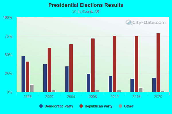
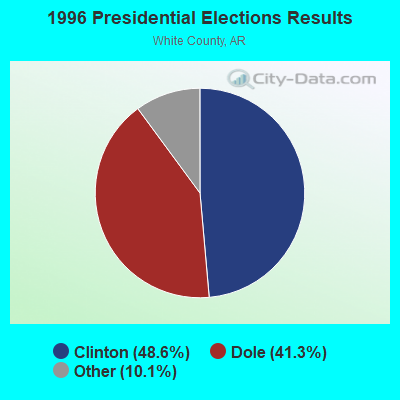
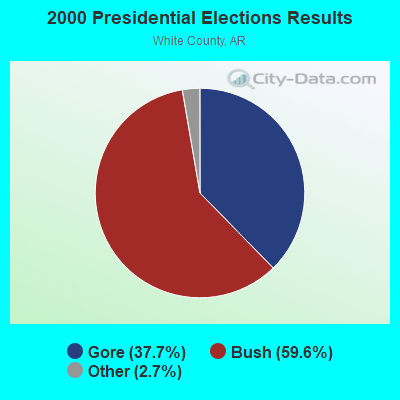
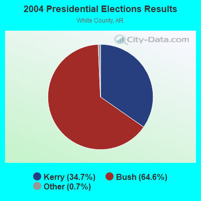
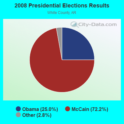
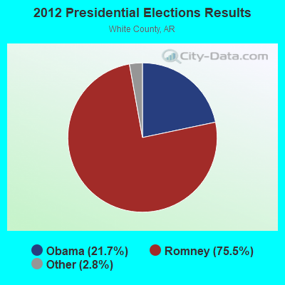
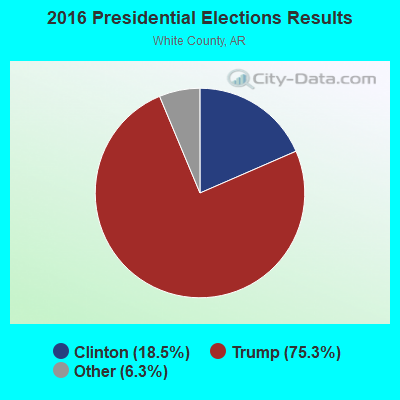
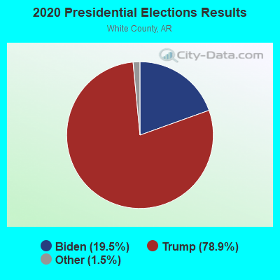
Graphs represent county-level data. Detailed 2008 Election Results
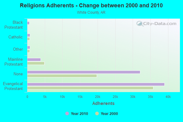
Religion statistics for Kensett, AR (based on White County data)
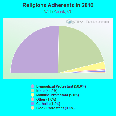
| Religion | Adherents | Congregations |
|---|---|---|
| Evangelical Protestant | 39,009 | 166 |
| Mainline Protestant | 3,838 | 30 |
| Other | 794 | 4 |
| Catholic | 749 | 2 |
| Black Protestant | 647 | 4 |
| None | 32,039 | - |
Food Environment Statistics:
| This county: | 1.90 / 10,000 pop. |
| State: | 2.02 / 10,000 pop. |
| White County: | 0.14 / 10,000 pop. |
| Arkansas: | 0.25 / 10,000 pop. |
| White County: | 0.41 / 10,000 pop. |
| State: | 0.59 / 10,000 pop. |
| This county: | 5.17 / 10,000 pop. |
| Arkansas: | 4.94 / 10,000 pop. |
| White County: | 6.12 / 10,000 pop. |
| Arkansas: | 6.66 / 10,000 pop. |
| Here: | 9.5% |
| State: | 9.8% |
| This county: | 28.0% |
| Arkansas: | 29.1% |
| White County: | 13.7% |
| Arkansas: | 13.6% |
Health and Nutrition:
| Here: | 47.8% |
| Arkansas: | 48.2% |
| This city: | 42.6% |
| Arkansas: | 44.2% |
| Kensett: | 29.1 |
| Arkansas: | 28.9 |
| Kensett: | 20.9% |
| Arkansas: | 21.6% |
| This city: | 13.8% |
| Arkansas: | 11.3% |
| Kensett: | 6.8 |
| Arkansas: | 6.8 |
| Kensett: | 35.6% |
| Arkansas: | 34.0% |
| Kensett: | 52.0% |
| Arkansas: | 54.4% |
| This city: | 76.8% |
| State: | 78.0% |
More about Health and Nutrition of Kensett, AR Residents
| Local government employment and payroll (March 2022) | |||||
| Function | Full-time employees | Monthly full-time payroll | Average yearly full-time wage | Part-time employees | Monthly part-time payroll |
|---|---|---|---|---|---|
| Police Protection - Officers | 4 | $13,558 | $40,674 | 2 | $547 |
| Solid Waste Management | 2 | $6,317 | $37,902 | 1 | $1,285 |
| Streets and Highways | 2 | $4,301 | $25,806 | 0 | $0 |
| Sewerage | 2 | $6,084 | $36,504 | 0 | $0 |
| Financial Administration | 1 | $5,181 | $62,172 | 1 | $3,499 |
| Judicial and Legal | 1 | $5,108 | $61,296 | 1 | $800 |
| Firefighters | 0 | $0 | 15 | $603 | |
| Other Government Administration | 0 | $0 | 8 | $2,050 | |
| Totals for Government | 12 | $40,549 | $40,549 | 28 | $8,784 |
Kensett government finances - Expenditure in 2018 (per resident):
- Current Operations - Police Protection: $243,000 ($172.10)
Water Utilities: $234,000 ($165.72)
Sewerage: $178,000 ($126.06)
Solid Waste Management: $121,000 ($85.69)
Regular Highways: $113,000 ($80.03)
Central Staff Services: $89,000 ($63.03)
Judicial and Legal Services: $31,000 ($21.95)
General - Other: $19,000 ($13.46)
Local Fire Protection: $14,000 ($9.92)
Protective Inspection and Regulation - Other: $7,000 ($4.96)
Financial Administration: $4,000 ($2.83)
Parks and Recreation: $1,000 ($0.71)
- General - Interest on Debt: $41,000 ($29.04)
- Other Capital Outlay - Water Utilities: $2,000 ($1.42)
- Total Salaries and Wages: $415,000 ($293.91)
Kensett government finances - Revenue in 2018 (per resident):
- Charges - Sewerage: $265,000 ($187.68)
Solid Waste Management: $115,000 ($81.44)
Other: $2,000 ($1.42)
- Miscellaneous - Fines and Forfeits: $181,000 ($128.19)
General Revenue - Other: $8,000 ($5.67)
Interest Earnings: $6,000 ($4.25)
Donations From Private Sources: $4,000 ($2.83)
- Revenue - Water Utilities: $272,000 ($192.63)
- State Intergovernmental - Highways: $118,000 ($83.57)
General Local Government Support: $44,000 ($31.16)
Other: $11,000 ($7.79)
- Tax - General Sales and Gross Receipts: $240,000 ($169.97)
Public Utilities Sales: $60,000 ($42.49)
Property: $28,000 ($19.83)
Occupation and Business License - Other: $1,000 ($0.71)
Other License: $1,000 ($0.71)
Kensett government finances - Debt in 2018 (per resident):
- Long Term Debt - Beginning Outstanding - Unspecified Public Purpose: $1,350,000 ($956.09)
Outstanding Unspecified Public Purpose: $1,350,000 ($956.09)
Kensett government finances - Cash and Securities in 2018 (per resident):
- Other Funds - Cash and Securities: $985,000 ($697.59)
- Sinking Funds - Cash and Securities: $164,000 ($116.15)
Strongest AM radio stations in Kensett:
- KWCK (1300 AM; daytime; 5 kW; SEARCY, AR; Owner: CALDWELL BROADCASTING, LLC)
- KGHT (880 AM; 50 kW; SHERIDAN, AR; Owner: METROPOLITAN RADIO GROUP, INC.)
- KAAY (1090 AM; 50 kW; LITTLE ROCK, AR; Owner: CITADEL BROADCASTING COMPANY)
- KMTL (760 AM; daytime; 10 kW; SHERWOOD, AR; Owner: GEORGE V. DOMERESE)
- KAPZ (710 AM; daytime; 0 kW; BALD KNOB, AR; Owner: CALDWELL BROADCASTING, LLC)
- WCRV (640 AM; 50 kW; COLLIERVILLE, TN; Owner: BOTT BROADCASTING COMPANY/TENNESSEE)
- WDIA (1070 AM; 50 kW; MEMPHIS, TN; Owner: CLEAR CHANNEL BROADCASTING LICENSES, INC.)
- WGSF (1030 AM; 50 kW; MEMPHIS, TN; Owner: FLINN BROADCASTING CORPORATION)
- KBBL (1350 AM; 2 kW; CABOT, AR; Owner: CABOT RADIO, INC.)
- WMQM (1600 AM; 50 kW; LAKELAND, TN; Owner: WMQM, INC.)
- KARN (920 AM; 5 kW; LITTLE ROCK, AR; Owner: CITADEL BROADCASTING COMPANY)
- KDXE (1380 AM; 5 kW; NORTH LITTLE ROCK, AR; Owner: RADIO DISNEY AM 1380, LLC)
- KLRG (1150 AM; 5 kW; NORTH LITTLE ROCK, AR; Owner: ARKANSAS RADIO CORPORATION)
Strongest FM radio stations in Kensett:
- KKSY (107.1 FM; BALD KNOB, AR; Owner: CALDWELL BROADCASTING, LLC)
- KABK-FM (97.7 FM; AUGUSTA, AR; Owner: FAMILY WORSHIP CENTER CHURCH, INC.)
- KBDO (91.7 FM; DES ARC, AR; Owner: AMERICAN FAMILY ASSOCIATION)
- KBGR (101.5 FM; BEEBE, AR; Owner: SEARCY BROADCASTING, INC.)
- KBMJ (89.5 FM; HEBER SPRINGS, AR; Owner: AMERICAN FAMILY ASSOCIATION)
- KOKR (96.7 FM; NEWPORT, AR; Owner: NEWPORT BROADCASTING COMPANY)
- KFLI (104.7 FM; DES ARC, AR; Owner: GEORGE S. FLINN, JR.)
- KWCK-FM (99.9 FM; SEARCY, AR; Owner: CALDWELL BROADCASTING, LLC)
- KSSN (95.7 FM; LITTLE ROCK, AR; Owner: CLEAR CHANNEL BROADCASTING LICENSES, INC.)
- KKPT (94.1 FM; LITTLE ROCK, AR; Owner: SIGNAL MEDIA OF ARKANSAS, INC.)
- KWOZ (103.3 FM; MOUNTAIN VIEW, AR; Owner: MOUNTAIN VIEW BROADCASTING CORP)
- KSMD (99.1 FM; PANGBURN, AR; Owner: CALDWELL BROADCASTING, LLC)
TV broadcast stations around Kensett:
- KATV (Channel 7; LITTLE ROCK, AR; Owner: KATV, LLC)
Kensett fatal accident list:
Jul 16, 1989 07:32 PM, Dandridge, Vehicles: 1, Persons: 3, Fatalities: 1
Feb 18, 1985 08:00 PM, 36s4, Vehicles: 1, Persons: 3, Fatalities: 1
- National Bridge Inventory (NBI) Statistics
- 2Number of bridges
- 23ft / 6.9mTotal length
- 2,347Total average daily traffic
- 70Total average daily truck traffic
- 3,022Total future (year 2028) average daily traffic
FCC Registered Antenna Towers:
15 (See the full list of FCC Registered Antenna Towers in Kensett)FCC Registered Microwave Towers:
2- LR90XC884, 100 Pruitt Road (Lat: 35.222667 Lon: -91.679472), Type: Ltower, Structure height: 74.1 m, Overall height: 75.3 m, Call Sign: WRCP860,
Assigned Frequencies: 10735.0 MHz, 10775.0 MHz, 10735.0 MHz, 10775.0 MHz, 10735.0 MHz, 10775.0 MHz, 10735.0 MHz, 10775.0 MHz, 10735.0 MHz, 10775.0 MHz... (+10 more), Grant Date: 11/30/2018, Expiration Date: 11/30/2028, Certifier: Jenny Knopf, Registrant: Dla Piper LLP, 500 8th Street, Nw, Washington, DC 20004, Phone: (202) 799-4216, Fax: (202) 799-5616, Email:
- AR01657A, 100 Pruitt Road (Lat: 35.222667 Lon: -91.679472), Type: Ltower, Structure height: 74.1 m, Overall height: 76.2 m, Call Sign: WRVC347,
Assigned Frequencies: 17980.0 MHz, 18060.0 MHz, 17980.0 MHz, 18060.0 MHz, 17980.0 MHz, 18060.0 MHz, 17980.0 MHz, 18060.0 MHz, 17980.0 MHz, 18060.0 MHz... (+20 more), Grant Date: 11/01/2022, Expiration Date: 11/01/2032, Certifier: Jenny Knopf, Registrant: T-Mobile Usa, Inc., 12920 Se 38th Street, Bellevue, WA 98006, Phone: (425) 383-8401, Fax: (425) 383-4040, Email:
FCC Registered Amateur Radio Licenses:
2- Call Sign: KE0RS, Previous Call Sign: WB6PDO, Licensee ID: L00680453, Grant Date: 07/23/2003, Expiration Date: 08/17/2013, Cancellation Date: 08/18/2015, Certifier: Ralph D D Canada Xxi, Registrant: Ralph D D Canada Xxi, 601 Maple Ave 15, Kensett, AR 72082
- Call Sign: KI5SS, Licensee ID: L00482869, Grant Date: 08/01/2012, Expiration Date: 09/01/2022, Registrant: Don Hamrick, 322 Rouse Street, Kensett, AR 72082
2002 - 2018 National Fire Incident Reporting System (NFIRS) incidents
- Fire incident types reported to NFIRS in Kensett, AR
- 6446.0%Structure Fires
- 6043.2%Outside Fires
- 1510.8%Mobile Property/Vehicle Fires
 According to the data from the years 2002 - 2018 the average number of fires per year is 8. The highest number of fire incidents - 20 took place in 2016, and the least - 0 in 2005. The data has an increasing trend.
 When looking into fire subcategories, the most reports belonged to: Structure Fires (46.0%), and Outside Fires (43.2%).
| Most common first names in Kensett, AR among deceased individuals | ||
| Name | Count | Lived (average) |
|---|---|---|
| Robert | 15 | 71.7 years |
| James | 14 | 74.4 years |
| William | 14 | 70.3 years |
| John | 11 | 79.9 years |
| Charles | 10 | 77.7 years |
| Mary | 10 | 83.6 years |
| George | 9 | 75.8 years |
| Joseph | 7 | 66.7 years |
| Walter | 6 | 79.5 years |
| Alice | 6 | 78.0 years |
| Most common last names in Kensett, AR among deceased individuals | ||
| Last name | Count | Lived (average) |
|---|---|---|
| Williams | 21 | 79.4 years |
| Jones | 18 | 74.8 years |
| Bailey | 12 | 78.3 years |
| Davis | 8 | 69.2 years |
| Brown | 7 | 45.0 years |
| Langley | 7 | 79.5 years |
| Taylor | 7 | 70.1 years |
| Wells | 6 | 77.0 years |
| Smith | 6 | 73.8 years |
| Baker | 5 | 76.8 years |
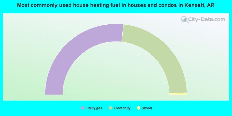
- 53.4%Utility gas
- 45.7%Electricity
- 0.9%Wood
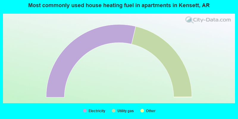
- 57.5%Electricity
- 42.5%Utility gas
Kensett compared to Arkansas state average:
- Median household income below state average.
- Median house value below state average.
- Unemployed percentage below state average.
- Hispanic race population percentage above state average.
- Foreign-born population percentage above state average.
- Length of stay since moving in significantly above state average.
- Institutionalized population percentage above state average.
- Percentage of population with a bachelor's degree or higher significantly below state average.
State forum archive:

|
Total of 1 patent application in 2008-2024.