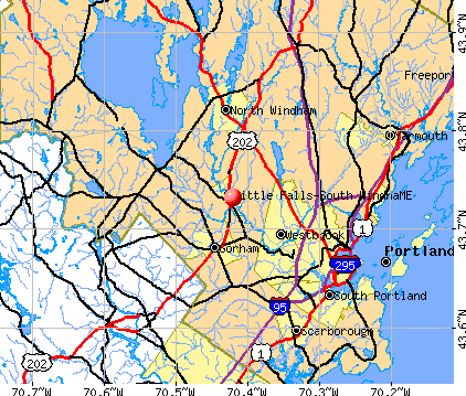
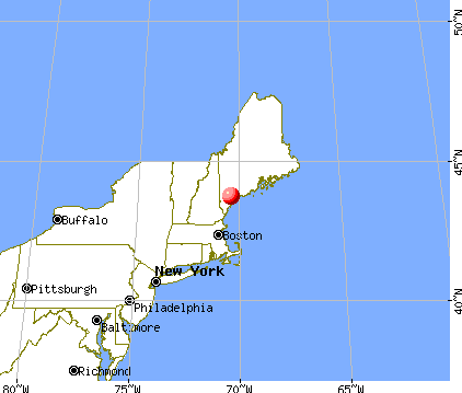
Little Falls-South Windham, Maine
Submit your own pictures of this place and show them to the world
- OSM Map
- General Map
- Google Map
- MSN Map
| Males: 1,154 | |
| Females: 705 |
| Median resident age: | 33.8 years |
| Maine median age: | 38.6 years |
Zip codes: 04062.
| Little Falls-South Windham: | $86,487 |
| ME: | $69,543 |
Estimated per capita income in 2022: $33,059 (it was $14,377 in 2000)
Little Falls-South Windham CDP income, earnings, and wages data
Estimated median house or condo value in 2022: $349,615 (it was $102,600 in 2000)
| Little Falls-South Windham: | $349,615 |
| ME: | $290,600 |
Mean prices in 2022: all housing units: $514,200; detached houses: $533,395; townhouses or other attached units: $572,947; in 2-unit structures: $538,406; in 3-to-4-unit structures: $462,507; in 5-or-more-unit structures: $450,834; mobile homes: $93,551
Little Falls-South Windham, ME residents, houses, and apartments details
Detailed information about poverty and poor residents in Little Falls-South Windham, ME
Compare current foreclosures near your location:
| Photo | Address | Area | Beds / Baths | Price | Details |
|---|---|---|---|---|---|

|
#1
S High St
Columbus, OH 43207
|
1,678 sq. feet
|
2 baths 4 beds |
$27,500
|
show details |

|
#2
Bayberry Cir
Columbus, OH 43207
|
1,564 sq. feet
|
1 baths 3 beds |
$127,500
|
show details |

|
#3
E 21st Ave
Columbus, OH 43211
|
1,061 sq. feet
|
1 baths 3 beds |
$179,900
|
show details |

|
#4
Hildreth Ave
Columbus, OH 43203
|
1,798 sq. feet
|
2 baths 4 beds |
show details | |

|
#5
Upton Rd E
Columbus, OH 43232
|
852 sq. feet
|
1 baths 3 beds |
show details | |

|
#6
Glenmate Ct
Columbus, OH 43223
|
1,050 sq. feet
|
1 baths 3 beds |
show details | |

|
#7
Hiawatha Park Dr
Columbus, OH 43211
|
1,278 sq. feet
|
1 baths 4 beds |
show details | |

|
#8
Fergus Rd
Grove City, OH 43123
|
3,312 sq. feet
|
2 baths 4 beds |
show details | |

|
#9
Cannonade Ct
Columbus, OH 43230
|
2,023 sq. feet
|
2 baths 3 beds |
show details | |

|
#10
Fairfield Ave
Columbus, OH 43203
|
984 sq. feet
|
1 baths 2 beds |
show details |
| Photo | Address | Area | Beds / Baths | Price | Details |
|---|---|---|---|---|---|

|
#11
E Howard Rd
Columbus, OH 43207
|
1,056 sq. feet
|
1 baths 3 beds |
show details | |

|
#12
E Welch Ave
Columbus, OH 43207
|
1,864 sq. feet
|
2 baths 4 beds |
show details | |

|
#13
Chester Rd
Columbus, OH 43221
|
3,300 sq. feet
|
4 baths 5 beds |
show details | |

|
#14
S Champion Ave
Columbus, OH 43207
|
1,157 sq. feet
|
1 baths 2 beds |
show details | |

|
#15
Executive Ct
Westerville, OH 43081
|
1,811 sq. feet
|
2 baths 3 beds |
show details | |

|
#16
Lehner Rd
Columbus, OH 43224
|
1,628 sq. feet
|
2 baths 4 beds |
show details | |

|
#17
Wrexham Ave
Columbus, OH 43223
|
1,235 sq. feet
|
1 baths 3 beds |
show details | |

|
#18
Summertree Ln
Westerville, OH 43081
|
2,496 sq. feet
|
2 baths 3 beds |
show details | |

|
#19
Armada Rd
Columbus, OH 43232
|
1,028 sq. feet
|
1 baths 4 beds |
show details | |

|
#20
Chidley St
Galloway, OH 43119
|
1,502 sq. feet
|
1 baths 3 beds |
show details |
| Photo | Address | Area | Beds / Baths | Price | Details |
|---|---|---|---|---|---|

|
#21
London Groveport Rd
Grove City, OH 43123
|
816 sq. feet
|
1 baths 2 beds |
show details | |

|
#22
N Roys Ave
Columbus, OH 43204
|
648 sq. feet
|
2 baths 3 beds |
show details | |

|
#23
E Lincoln Ave
Columbus, OH 43214
|
874 sq. feet
|
1 baths 3 beds |
show details | |

|
#24
N Roys Ave
Columbus, OH 43204
|
1,248 sq. feet
|
2 baths 3 beds |
show details | |

|
#25
Falls Peak Ln
Delaware, OH 43015
|
1,352 sq. feet
|
2 baths 2 beds |
show details | |

|
#26
Striebel Ct
Columbus, OH 43227
|
925 sq. feet
|
1 baths 3 beds |
show details | |

|
#27
Rosewood Ct
Powell, OH 43065
|
2,801 sq. feet
|
3 baths 4 beds |
show details | |

|
#28
Whittman Ct
Plain City, OH 43064
|
3,186 sq. feet
|
3 baths 4 beds |
show details | |

|
#29
Hamilton Ave
Columbus, OH 43211
|
1,061 sq. feet
|
1 baths 3 beds |
show details | |

|
#30
High Free Pike
West Jefferson, OH 43162
|
1,216 sq. feet
|
2 baths 4 beds |
show details |
| Photo | Address | Area | Beds / Baths | Price | Details |
|---|---|---|---|---|---|

|
#31
Kelton Ave
Columbus, OH 43206
|
1,080 sq. feet
|
1 baths 3 beds |
show details | |

|
#32
Ashgrove Dr
Grove City, OH 43123
|
1,772 sq. feet
|
2 baths 4 beds |
show details | |

|
#33
Roundelay Rd N
Reynoldsburg, OH 43068
|
1,712 sq. feet
|
2 baths 3 beds |
show details | |

|
#34
Grasmere Ave
Columbus, OH 43211
|
720 sq. feet
|
1 baths 2 beds |
show details | |

|
#35
S Richardson Ave
Columbus, OH 43204
|
1,520 sq. feet
|
2 baths 3 beds |
show details | |

|
#36
N 18th St
Columbus, OH 43203
|
1,690 sq. feet
|
1 baths 4 beds |
show details | |

|
#37
Gladys Rd
Columbus, OH 43228
|
832 sq. feet
|
1 baths 3 beds |
show details | |

|
#38
Plainview Dr
Columbus, OH 43204
|
730 sq. feet
|
1 baths 2 beds |
show details | |

|
#39
Lowery Dr
Columbus, OH 43231
|
1,557 sq. feet
|
2 baths 3 beds |
show details | |

|
#40
Gertrude Dr
Columbus, OH 43227
|
1,287 sq. feet
|
1 baths 3 beds |
show details |
| Photo | Address | Area | Beds / Baths | Price | Details |
|---|---|---|---|---|---|

|
#41
Grand Bend Dr
Groveport, OH 43125
|
1,612 sq. feet
|
1 baths 3 beds |
show details | |

|
#42
Justin Rd
Columbus, OH 43227
|
986 sq. feet
|
1 baths 3 beds |
show details | |

|
#43
Crocker Rd
Columbus, OH 43232
|
895 sq. feet
|
1 baths 3 beds |
show details | |

|
#44
Wendler Blvd
Columbus, OH 43230
|
1,040 sq. feet
|
1 baths 3 beds |
show details | |

|
#45
Sapphire Dr
Grove City, OH 43123
|
3,241 sq. feet
|
3 baths 4 beds |
show details | |

|
#46
Dinard Way
Columbus, OH 43221
|
1,647 sq. feet
|
2 baths 3 beds |
show details | |

|
#47
Edgeview Rd
Columbus, OH 43207
|
1,352 sq. feet
|
1 baths 4 beds |
show details | |

|
#48
Torchwood Loop E
Columbus, OH 43229
|
2,116 sq. feet
|
2 baths 4 beds |
show details | |

|
#49
Pegwood Dr
Columbus, OH 43229
|
878 sq. feet
|
1 baths 1 beds |
show details | |

|
Check over 1 million property listings on Foreclosure.com!
|
browse all offers | |||

- 1,70695.2%White alone
- 301.7%Black alone
- 201.1%Two or more races
- 150.8%American Indian alone
- 140.8%Hispanic
- 60.3%Asian alone
- 10.06%Native Hawaiian and Other
Pacific Islander alone

 Recent articles from our blog. Our writers, many of them Ph.D. graduates or candidates, create easy-to-read articles on a wide variety of topics.

Ancestries: Irish (18.9%), English (15.2%), French (9.7%), German (5.7%), Scottish (5.7%), United States (3.0%).
Current Local Time: EST time zone
Land area: 2.37 square miles.
Population density: 783 people per square mile (low).
52 residents are foreign born (2.2% Europe, 0.7% North America).
| This place: | 2.9% |
| Maine: | 2.9% |
| Little Falls-South Windham CDP: | 1.4% ($1,444) |
| Maine: | 1.5% ($1,417) |
Nearest city with pop. 50,000+: Portland, ME  (8.9 miles , pop. 64,249).
Nearest city with pop. 200,000+: Boston, MA (103.2 miles , pop. 589,141).
Nearest city with pop. 1,000,000+: Bronx, NY (266.5 miles , pop. 1,332,650).
Nearest cities:
), ), ), Latitude: 43.73 N, Longitude: 70.42 W
Area code commonly used in this area: 207


| Here: | 2.8% |
| Maine: | 3.4% |

- Health care (12.2%)
- Construction (9.7%)
- Miscellaneous manufacturing (7.0%)
- Finance & insurance (6.5%)
- Educational services (6.1%)
- Administrative & support & waste management services (5.9%)
- Public administration (5.9%)

- Construction (15.7%)
- Miscellaneous manufacturing (7.5%)
- Professional, scientific, technical services (6.3%)
- Administrative & support & waste management services (6.3%)
- Food (5.6%)
- Accommodation & food services (5.3%)
- Wood products (4.4%)

- Health care (22.2%)
- Educational services (10.4%)
- Finance & insurance (9.6%)
- Public administration (8.1%)
- Miscellaneous manufacturing (6.3%)
- Administrative & support & waste management services (5.6%)
- Religious, grantmaking, civic, professional, similar organizations (5.2%)

- Other management occupations, except farmers and farm managers (6.8%)
- Electrical equipment mechanics and other installation, maintenance, and repair workers, including supervisors (5.4%)
- Carpenters (5.3%)
- Financial clerks, except bookkeeping, accounting and auditing clerks (3.7%)
- Advertising, marketing, promotions, public relations, and sales managers (3.6%)
- Building and grounds cleaning and maintenance occupations (3.6%)
- Drafters, engineering, and mapping technicians (3.6%)

- Electrical equipment mechanics and other installation, maintenance, and repair workers, including supervisors (10.0%)
- Carpenters (9.7%)
- Drafters, engineering, and mapping technicians (6.6%)
- Computer specialists (5.3%)
- Driver/sales workers and truck drivers (5.3%)
- Other sales and related occupations, including supervisors (5.0%)
- Other management occupations, except farmers and farm managers (4.1%)

- Other management occupations, except farmers and farm managers (10.0%)
- Secretaries and administrative assistants (7.0%)
- Financial clerks, except bookkeeping, accounting and auditing clerks (6.3%)
- Building and grounds cleaning and maintenance occupations (5.2%)
- Advertising, marketing, promotions, public relations, and sales managers (4.8%)
- Health technologists and technicians (4.8%)
- Cashiers (3.7%)
Average climate in Little Falls-South Windham, Maine
Based on data reported by over 4,000 weather stations


(lower is better)

Air Quality Index (AQI) level in 2023 was 70.4. This is about average.
| City: | 70.4 |
| U.S.: | 72.6 |

Carbon Monoxide (CO) [ppm] level in 2021 was 0.192. This is better than average. Closest monitor was 9.0 miles away from the city center.
| City: | 0.192 |
| U.S.: | 0.251 |

Nitrogen Dioxide (NO2) [ppb] level in 2023 was 5.47. This is about average. Closest monitor was 9.0 miles away from the city center.
| City: | 5.47 |
| U.S.: | 5.11 |

Sulfur Dioxide (SO2) [ppb] level in 2020 was 0.222. This is significantly better than average. Closest monitor was 4.4 miles away from the city center.
| City: | 0.222 |
| U.S.: | 1.515 |

Ozone [ppb] level in 2023 was 29.0. This is about average. Closest monitor was 9.0 miles away from the city center.
| City: | 29.0 |
| U.S.: | 33.3 |


Particulate Matter (PM2.5) [µg/m3] level in 2023 was 6.49. This is better than average. Closest monitor was 4.6 miles away from the city center.
| City: | 6.49 |
| U.S.: | 8.11 |
Tornado activity:
Little Falls-South Windham-area historical tornado activity is above Maine state average. It is 76% smaller than the overall U.S. average.
On 10/10/1966, a category F2 (max. wind speeds 113-157 mph) tornado 27.6 miles away from the Little Falls-South Windham place center caused between $5000 and $50,000 in damages.
On 6/22/1981, a category F2 tornado 37.9 miles away from the place center caused between $500,000 and $5,000,000 in damages.
Earthquake activity:
Little Falls-South Windham-area historical earthquake activity is significantly above Maine state average. It is 74% smaller than the overall U.S. average.On 10/16/2012 at 23:12:25, a magnitude 4.7 (4.7 ML, Depth: 10.0 mi, Class: Light, Intensity: IV - V) earthquake occurred 15.0 miles away from Little Falls-South Windham center
On 4/20/2002 at 10:50:47, a magnitude 5.3 (5.3 ML, Depth: 3.0 mi, Class: Moderate, Intensity: VI - VII) earthquake occurred 171.4 miles away from Little Falls-South Windham center
On 1/19/1982 at 00:14:42, a magnitude 4.7 (4.5 MB, 4.7 MD, 4.5 LG) earthquake occurred 61.2 miles away from the city center
On 4/20/2002 at 10:50:47, a magnitude 5.2 (5.2 MB, 4.2 MS, 5.2 MW, 5.0 MW) earthquake occurred 171.9 miles away from Little Falls-South Windham center
On 10/7/1983 at 10:18:46, a magnitude 5.3 (5.1 MB, 5.3 LG, 5.1 ML) earthquake occurred 196.2 miles away from Little Falls-South Windham center
On 8/21/1996 at 07:54:14, a magnitude 3.8 (3.8 LG, 3.6 LG, Depth: 6.2 mi, Class: Light, Intensity: II - III) earthquake occurred 55.9 miles away from the city center
Magnitude types: regional Lg-wave magnitude (LG), body-wave magnitude (MB), duration magnitude (MD), local magnitude (ML), surface-wave magnitude (MS), moment magnitude (MW)
Natural disasters:
The number of natural disasters in Cumberland County (33) is a lot greater than the US average (15).Major Disasters (Presidential) Declared: 22
Emergencies Declared: 10
Causes of natural disasters: Floods: 19, Storms: 13, Snows: 7, Winter Storms: 6, Heavy Rains: 3, Hurricanes: 3, Winds: 3, Blizzard: 1, Ice Storm: 1, Mudslide: 1, Snowfall: 1, Snowstorm: 1, Tornado: 1, Other: 2 (Note: some incidents may be assigned to more than one category).

Hospitals and medical centers near Little Falls-South Windham:
- GORHAM HOUSE (Nursing Home, about 4 miles away; GORHAM, ME)
- GORHAM HEALTH CENTER (Nursing Home, about 4 miles away; GORHAM, ME)
- WESTBROOK COMMUNITY HOSPITAL (Hospital, about 5 miles away; WESTBROOK, ME)
- SPRINGBROOK CENTER (Nursing Home, about 6 miles away; WESTBROOK, ME)
- CASCO BAY DIALYSIS FACILITY (Dialysis Facility, about 6 miles away; WESTBROOK, ME)
- BARRON CENTER (Nursing Home, about 7 miles away; PORTLAND, ME)
- ST JOSEPH'S REHABILITATION AND RESIDENCE (Nursing Home, about 8 miles away; PORTLAND, ME)
Amtrak stations near Little Falls-South Windham:
Colleges/universities with over 2000 students nearest to Little Falls-South Windham:
- Saint Joseph's College of Maine (about 8 miles; Standish, ME; Full-time enrollment: 2,010)
- University of Southern Maine (about 9 miles; Portland, ME; FT enrollment: 6,647)
- Southern Maine Community College (about 12 miles; South Portland, ME; FT enrollment: 4,666)
- University of New England (about 20 miles; Biddeford, ME; FT enrollment: 4,539)
- University of New Hampshire-Main Campus (about 49 miles; Durham, NH; FT enrollment: 15,243)
- University of Maine at Augusta (about 53 miles; Augusta, ME; FT enrollment: 3,204)
- Plymouth State University (about 64 miles; Plymouth, NH; FT enrollment: 4,838)
Points of interest:
Notable locations in Little Falls-South Windham: State Reformatory for Men (A), Windham Fire Rescue Department District 1 (B). Display/hide their locations on the map
Churches in Little Falls-South Windham include: Little Falls Baptist Church (A), South Windham Community Church (B). Display/hide their locations on the map
Cemetery: Old Anderson Cemetery (1). Display/hide its location on the map
Streams, rivers, and creeks: Ward Brook (A), Colley Wright Brook (B), Little River (C), Black Brook (D). Display/hide their locations on the map
| This place: | 2.5 people |
| Maine: | 2.4 people |
| This place: | 69.5% |
| Whole state: | 66.1% |
| This place: | 10.4% |
| Whole state: | 7.3% |
Likely homosexual households (counted as self-reported same-sex unmarried-partner households)
- Lesbian couples: 0.0% of all households
- Gay men: 0.6% of all households
| This place: | 5.2% |
| Whole state: | 10.9% |
| This place: | 0.7% |
| Whole state: | 4.1% |
15 people in homes or halfway houses for drug/alcohol abuse in 2000
For population 15 years and over in Little Falls-South Windham:

- Never married: 25.5%
- Now married: 59.0%
- Separated: 2.6%
- Widowed: 3.9%
- Divorced: 9.1%
For population 25 years and over in Little Falls-South Windham:
- High school or higher: 86.1%
- Bachelor's degree or higher: 11.9%
- Graduate or professional degree: 4.2%
- Unemployed: 5.8%
- Mean travel time to work (commute): 24.3 minutes


| Here: | 10.6 |
| Maine average: | 11.2 |
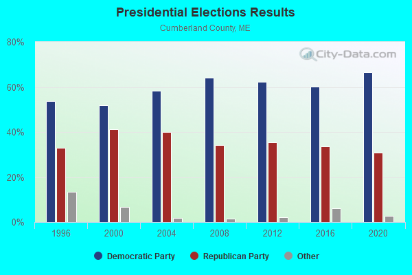
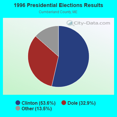
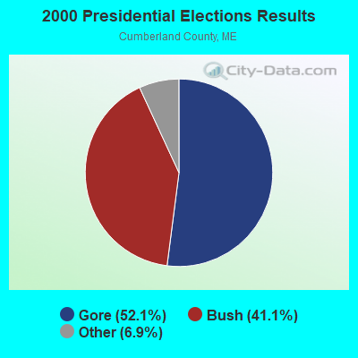
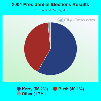
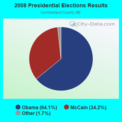
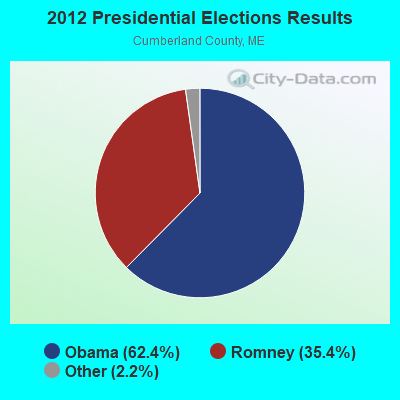
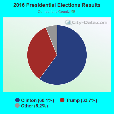
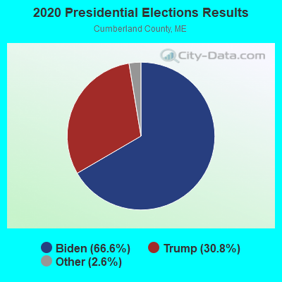
Graphs represent county-level data. Detailed 2008 Election Results
Religion statistics for Little Falls-South Windham, ME (based on Cumberland County data)
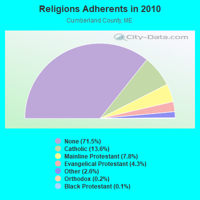
| Religion | Adherents | Congregations |
|---|---|---|
| Catholic | 38,243 | 19 |
| Mainline Protestant | 22,030 | 96 |
| Evangelical Protestant | 12,007 | 85 |
| Other | 7,187 | 44 |
| Orthodox | 500 | 1 |
| Black Protestant | 285 | 2 |
| None | 201,422 | - |
Food Environment Statistics:
| Cumberland County: | 2.62 / 10,000 pop. |
| State: | 2.80 / 10,000 pop. |
| This county: | 0.11 / 10,000 pop. |
| Maine: | 0.14 / 10,000 pop. |
| This county: | 2.44 / 10,000 pop. |
| Maine: | 2.20 / 10,000 pop. |
| Cumberland County: | 3.82 / 10,000 pop. |
| Maine: | 5.75 / 10,000 pop. |
| Cumberland County: | 12.01 / 10,000 pop. |
| Maine: | 11.02 / 10,000 pop. |
| Here: | 7.1% |
| State: | 8.2% |
| Cumberland County: | 19.5% |
| State: | 25.0% |
Strongest AM radio stations in Little Falls-South Windham:
- WMTW (870 AM; 10 kW; GORHAM, ME; Owner: RADIO PARTNERS OF MAINE, L.P.)
- WGAN (560 AM; 5 kW; PORTLAND, ME; Owner: SAGA COMMUNICATIONS OF NEW ENGLAND, LLC)
- WJAE (1440 AM; 5 kW; WESTBROOK, ME; Owner: ALTANTIC COAST RADIO, LLC)
- WLOB (1310 AM; 5 kW; PORTLAND, ME; Owner: ATLANTIC COAST RADIO, LLC)
- WZAN (970 AM; 5 kW; PORTLAND, ME; Owner: SAGA COMMUNICATIONS OF NEW ENGLAND, LLC)
- WBAE (1490 AM; 1 kW; PORTLAND, ME; Owner: SAGA COMMUNICATIONS OF NEW ENGLAND, LLC)
- WRKO (680 AM; 50 kW; BOSTON, MA; Owner: ENTERCOM BOSTON LICENSE, LLC)
- WGIN (930 AM; 10 kW; ROCHESTER, NH; Owner: CAPSTAR TX LIMITED PARTNERSHIP)
- WLAM (1470 AM; 5 kW; LEWISTON, ME; Owner: RADIO PARTNERS OF MAINE, L.P.)
- WEEI (850 AM; 50 kW; BOSTON, MA; Owner: ENTERCOM BOSTON LICENSE, LLC)
- WBZ (1030 AM; 50 kW; BOSTON, MA; Owner: INFINITY BROADCASTING OPERATIONS, INC.)
- WTME (780 AM; 10 kW; RUMFORD, ME; Owner: MOUNTAIN VALLEY BROADCASTING, INC.)
- WCRN (830 AM; 50 kW; WORCESTER, MA; Owner: CARTER BROADCASTING CORPORATION)
Strongest FM radio stations in Little Falls-South Windham:
- WPOR (101.9 FM; PORTLAND, ME; Owner: SAGA COMMUNICATIONS OF NEW ENGLAND, LLC)
- WMSJ (89.3 FM; FREEPORT, ME; Owner: DOWNEAST CHRISTIAN COMMUNICATIONS)
- WJBQ (97.9 FM; PORTLAND, ME; Owner: CITADEL BROADCASTING COMPANY)
- WMEA (90.1 FM; PORTLAND, ME; Owner: MAINE PUBLIC BROADCASTING CORPORATION)
- WBLM (102.9 FM; PORTLAND, ME; Owner: CITADEL BROADCASTING COMPANY)
- WMPG (90.9 FM; GORHAM, ME; Owner: UNIVERSITY OF MAINE SYSTEM)
- WMTW-FM (106.7 FM; NORTH WINDHAM, ME; Owner: RADIO PARTNERS OF MAINE, L.P.)
- WMGX (93.1 FM; PORTLAND, ME; Owner: SAGA COMMUNICATIONS OF NEW ENGLAND, LLC)
- WTHT (107.5 FM; LEWISTON, ME; Owner: RADIO PARTNERS OF MAINE, L.P.)
- WPKQ (103.7 FM; NORTH CONWAY, NH; Owner: CITADEL BROADCASTING COMPANY)
- WHOM (94.9 FM; MT. WASHINGTON, NH; Owner: CITADEL BROADCASTING COMPANY)
- WCYY (94.3 FM; BIDDEFORD, ME; Owner: CITADEL BROADCASTING COMPANY)
- WMEK-FM (99.9 FM; AUBURN, ME; Owner: RADIO PARTNERS OF MAINE, L.P.)
- WRED (95.9 FM; SACO, ME; Owner: ATLANTIC COAST RADIO, LLC)
- WBQW (106.3 FM; SCARBOROUGH, ME; Owner: MARINER BROADCASTING LIMITED PARTNER)
- WSCY (106.9 FM; MOULTONBOROUGH, NH; Owner: NORTHEAST COMMUNICATIONS CORPORATION)
- W245AA (96.9 FM; PORTLAND, ME; Owner: RADIO PARTNERS OF MAINE, L.P.)
- WYNZ (100.9 FM; WESTBROOK, ME; Owner: SAGA COMMUNICATIONS OF NEW ENGLAND, LLC)
- WVFM (105.7 FM; CAMPTON, NH; Owner: DEVON BROADCASTING COMPANY, INC.)
- WJJB-FM (95.5 FM; TOPSHAM, ME; Owner: ATLANTIC COAST RADIO, LLC)
TV broadcast stations around Little Falls-South Windham:
- WGME-TV (Channel 13; PORTLAND, ME; Owner: WGME LICENSEE, LLC)
- WPXT (Channel 51; PORTLAND, ME; Owner: HMW, INC.)
- WPME (Channel 35; LEWISTON, ME; Owner: KB PRIME MEDIA LLC)
- WMTW-TV (Channel 8; POLAND SPRING, ME; Owner: WMTW BROADCAST GROUP, LLC)
- WCSH (Channel 6; PORTLAND, ME; Owner: PACIFIC AND SOUTHERN COMPANY, INC.)
- W58CM (Channel 58; BANGOR, ME; Owner: MS COMMUNICATIONS, LLC)
- W32CA (Channel 32; PORTLAND, ME; Owner: NATIONAL MINORITY T.V., INC.)
- W57AP (Channel 57; FALMOUTH, ME; Owner: SHERWOOD H. CRAIG)
- WLLB-LP (Channel 15; PORTLAND, ME; Owner: CARTER BROADCASTING CORPORATION)
- WMEA-TV (Channel 26; BIDDEFORD, ME; Owner: MAINE PUBLIC BROADCASTING CORP.)
- WPFO (Channel 23; WATERVILLE, ME; Owner: CMCG PORTLAND LICENSE LLC)
- National Bridge Inventory (NBI) Statistics
- 1Number of bridges
- 13ft / 4.2mTotal length
- 6,960Total average daily traffic
- 556Total average daily truck traffic
- 7,660Total future (year 2038) average daily traffic

- 87.2%Fuel oil, kerosene, etc.
- 6.5%Bottled, tank, or LP gas
- 4.2%Electricity
- 2.1%Wood

- 82.5%Fuel oil, kerosene, etc.
- 17.5%Bottled, tank, or LP gas
Little Falls-South Windham compared to Maine state average:
- Unemployed percentage below state average.
- Hispanic race population percentage below state average.
- Median age significantly below state average.
- Renting percentage significantly below state average.
- Length of stay since moving in significantly above state average.
- Number of rooms per house significantly below state average.
- House age significantly below state average.
- Institutionalized population percentage significantly above state average.
- Percentage of population with a bachelor's degree or higher significantly below state average.
Little Falls-South Windham on our top lists:
- #69 on the list of "Top 101 cities with the largest percentage of people in homes or halfway houses for drug/alcohol abuse (population 1,000+)"
- #73 on the list of "Top 101 cities with the largest percentage of people in state prisons (population 1,000+)"
- #28 on the list of "Top 101 counties with the highest percentage of residents that exercised in the past month"
- #30 on the list of "Top 101 counties with the best general health status score of residents (1-5), 3 years of data"
- #40 on the list of "Top 101 counties with the highest percentage of residents that visited a dentist within the past year"
- #43 on the list of "Top 101 counties with the highest Nitrogen Dioxide air pollution readings in 2012 (ppm)"
- #49 on the list of "Top 101 counties with the lowest number of births per 1000 residents 2007-2013"